CITY OF POWAY MEMORANDUM
|
|
|
- Nathaniel Cameron
- 6 years ago
- Views:
Transcription

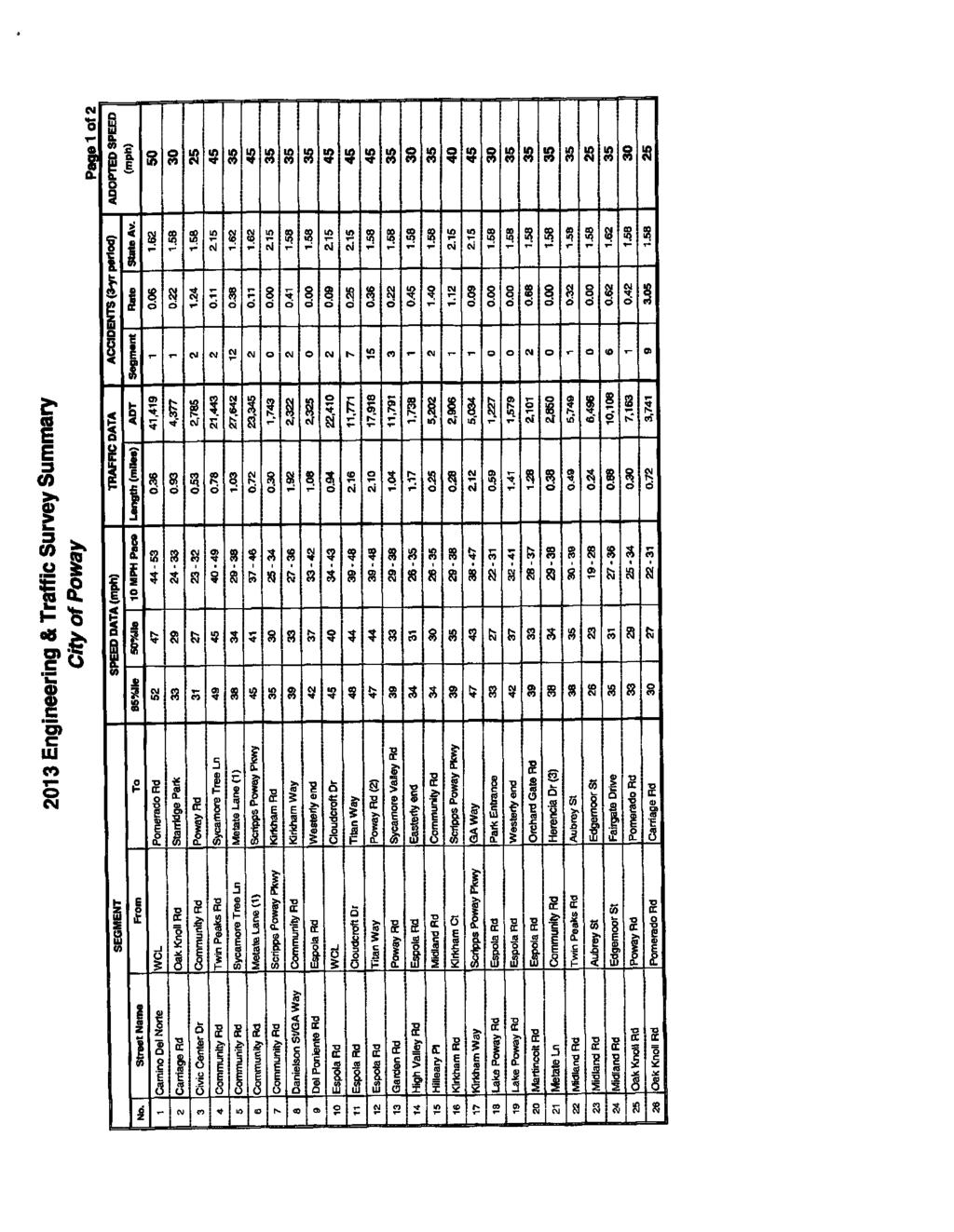
1 CITY OF POWAY MEMORANDUM TO: FROM: Traffic Safety Committee Steve Crosby P.E., City Engineer DATE: February 14, 2018 SUBJECT: Espola Road speeding concerns BACKGROUND In 2017, staff received a request from residents to consider the installation of permanent driver speed feedback signs on Espola Road between Sand Hill Road and Trailwind Road. The Sheriff s department has placed their mobile speed feedback trailer on this stretch of Espola Road at various times in response to resident concerns over drivers exceeding the speed limit. In order to evaluate the request for permanent speed feedback signs, traffic engineering staff conducted a field investigation of the subject area, researched collision histories, performed a radar speed survey on Espola Road, and reviewed how the current speed limit on Espola Road was established. FINDINGS Espola Road between Cloudcroft Drive and Titan Way is a four-lane arterial with a striped median. The Average Daily Traffic is 11,771 vehicles based on the 2013 Engineering and Traffic Survey (E&TS). The travel lanes vary in size but are at a minimum of twelve feet. There is a large horizontal curve that starts at Old Coach Road and terminates north of Country Day Road. Bike lanes are provided on both sides of the roadway. A sidewalk is provided on the North/East side and a dirt equestrian/pedestrian trail is provided on the South/West side of the street. There are a few residential driveways that take access from the south side of the street in the vicinity of Orchard Bend Road. Otherwise there is limited access along this stretch of roadway. The current posted speed limit on this stretch of road is 45 MPH. A review of the Transportation Injury Mapping System accident database found a total of ten accidents on this stretch of road from 2011 to One accident was determined to be related to unsafe speed. The other accidents were related to turns at the intersections, run off the road collisions with fixed objects or DUIs. The accident rate for this segment of roadway was 0.25 accidents per million vehicle miles compared to the Statewide average of 2.15 based on the findings from the 2013 E&TS.
2 Radar speed survey data was collected on November 28, 2017 on Espola Road north of Sandhill Road. The speed survey results are shown in Attachment A. It should be noted that the data has not been certified and therefore is not a valid speed survey for enforcement of the speed limit on this road. The data was only collected for informational purposes of this report. The posted speed limit on this segment of Espola Road is 45 MPH. The measured 50 th percentile Speed was 48 MPH and the 85 th percentile speed was 52 MPH in the southbound direction, and the measured 50 th percentile Speed was 48 MPH and the 85 th percentile speed was 53 MPH in the northbound direction. It should be noted that of the 224 vehicle speeds that were measured, 166 were measured travelling over the posted speed limit. Sections and of the California Vehicle Code (CVC) gives local municipalities the authority to set speed limits below the maximum speed limits set forth by State law, where such speed limits are supported by an E&TS. The E&TS enables our Sheriff s Deputies to use radar for traffic speed enforcement and serve as legal authority in accordance with the CVC. The City s current E&TS (Attachment B) adopted in 2013 was prepared pursuant to the guidelines of a previous edition of the California MUTCD. The MUTCD calls for speed limits to be established to the nearest 5 MPH increment of the 85 th percentile speed. For example, if the 85 th percentile speed is 47 MPH, the speed limit should be posted at 45 MPH. However, if the 85 th percentile speed is 48 MPH, the speed limit should be posted at 50 MPH. Section of the CVC gives local agencies the authority to lower the speed limit an additional 5 MPH below the adjusted 85 th percentile when there are conditions that are not apparent to drivers, which manifest in higher accident rates on the roadway. These include driveways directly abutting the roadway with frequent turns, insufficient sight distances, mid-block pedestrian and/or equestrian crossings, and pedestrians and bikers along the roadway. Roadway physical conditions, such as width, curvature, grade and surface conditions are not considered conditions not apparent to drivers by State law. Previously, the 5 MPH reduction rule under Section could be used if the speed limit was set to the nearest 5 MPH increment of the 85 th percentile speed. Now however, if the closest 5 MPH increment is also the lowest 5 MPH increment, the additional 5 MPH reduction cannot be used. For example, an 85 th percentile speed of 52 MPH would be rounded to 50 MPH and the additional 5 MPH reduction would not be allowed because 50 MPH is the nearest as well as the lowest 5 MPH increment. An 85 th percentile speed of 53 MPH would be rounded to 55 MPH, and with the 5 MPH reduction the speed limit could be reduced to 50 MPH if warranted by roadway conditions. Data from the 2013 E&TS shows an 85 th percentile speed of 48 MPH for Espola Road. Based on the California MUTCD and the latest Caltrans Traffic Operation Policy Directive #09-04, Change in current California MUTCD policy and procedure for setting speed limits in California, the speed limit on Espola Road would be set at 50 MPH, which is the nearest 5 MPH increment speed to the 85 th percentile speed of 48
3 MPH. However, staff at that time determined that the pedestrian/equestrian uses along the roadway justified use of the 5 MPH reduction rule in the posted speed, and staff recommended a 45 MPH speed limit for Espola Road along this segment. Based on the results of the recent uncertified speed survey data which indicated 85 th percentile speeds of 52 and 53 MPH, the posted speed limit would be set at 50 MPH. Staff would not be allowed to reduce the posted speed to 45 MPH based on the current criteria for use of the 5 MPH reduction rule. DISCUSSION Staff believes that there are four options for addressing vehicle speed on Espola Road. Increased Enforcement- The Sherriff s Department does cite vehicles along this stretch of Espola Road. The citations are valid based on the certified speed limit of 45 MPH that was completed with the 2013 E&TS. Increased enforcement combined with periodic deployment of the Sheriff s mobile speed feedback trailer is a viable option. Installation of permanent speed feedback signs- Permanent speed feedback signs have been installed in other areas of the City. Based on those installations, the anticipated cost would be $10,000 to $15,000 per installation for a pole mounted vehicle speed feedback sign in the shoulder of the road. However, Espola Road in this section is a wide four-lane facility with a striped median and a roadside shoulder installation may not be as effective as a mast arm installation extending over the travel lanes. Mast arm installation would significantly increase the cost per location. Staff has not determined the exact locations or type of speed feedback signs to provide the most benefit at reducing speeds on this segment of Espola Road. Increasing the Posted Speed- The 2013 ET&S findings reported an 85 th percentile speed of 48 MPH which would warrant a posted speed of 50 MPH. This was reduced to 45 MPH based on the 5 MPH increment reduction rule allowance. Changing the posted speed based on the recent speed survey conducted, which resulted in 85 th percentile speeds of 52 and 53 MPH, would result in a recommended posted speed of 50 MPH. Staff would not be allowed to reduce the posted speed to 45 MPH based on the current criteria for use of the 5 MPH reduction rule. The posted speed would have to be 50 MPH. This change would require following certain procedures including adoption by City Council in order for the new speed limit to be enforceable. Traffic Calming Through Striping Changes- Staff has restriped other roadway segments within the City in recent years to aid in the following: reducing driver speed due to driver perception of narrower lanes provide wider bike lanes provide bike lane buffers Bike lane buffers have been added to Scripps Poway Parkway, Pomerado Road, and most recently Poway road. The additional width required for the bike lane buffers was taken from the through travel lanes resulting in a narrowing of those lanes. The minimum lane widths have been held to eleven feet. For reference, Caltrans standard freeway lane width is twelve feet. The existing lanes on Espola Road currently vary to
4 more than thirteen feet in width. This section of Espola Road is scheduled to receive slurry seal in summer of This provides the opportunity to restripe the roadway starting with a clean slate. The road could be restriped with bike buffers and eleven foot maximum through lanes as shown in Attachment C. RECOMMENDATION Staff recommends that the Sheriff s Department increase enforcement in the area as resources are available. Staff also recommends restriping the road to install the bike lane buffers and narrow the travel lanes to eleven feet. After the restriping is implemented staff recommends conducting another radar speed survey to determine if the restriping was effective at lowering speed to be more in line with the current posted speed of 45 MPH. If speed survey result indicate that the restriping was ineffective at reducing speeds the permanent vehicle speed feedback sign option can be considered at that time. Attachments: A. Radar speed survey results B ET&S Espola Road speed survey section C. Proposed Espola Road Restriping
5
6
7
8
9
10
11 Attachment C Espola Road Existing Condition 5' Bike Lane 13' 12' 15' Center Turn Lane 12' 13' 5' Bike Lane 75 Proposed Condition 6' Bike Lane 3' Buffer 11' 11' 13' Center Turn Lane 11' 11' 3' Buffer 6' Bike Lane 75 Espola Road between Cloudcroft Drive and Lake Poway Road Cross-Sections
TRAFFIC & TRANSPORTATION COMMISSION AGENDA REPORT
 TRAFFIC & TRANSPORTATION COMMISSION AGENDA REPORT AGENDA ITEM #3 T/T MTG: 072815 DATE: JULY 28, 2015 TO: TRAFFIC & TRANSPORTATION COMMISSION FROM: BENJAMIN CHAN, P.E, T.E., DEPUTY PUBLIC WORKS DIRECTOR
ORANGE COUNTY TRAFFIC COMMITTEE. Speed Limit. Sellas Road North/Sellas Road South; Ladera Ranch; TB 952-F1. Traffic Engineering.
 ORANGE COUNTY TRAFFIC COMMITTEE SUPERVISORIAL DISTRICT: 5 SUBJECT: LOCATION: INITIATED BY: INVESTIGATOR: REQUEST: Speed Limit Sellas Road North/Sellas Road South; Ladera Ranch; TB 952-F1 Traffic Engineering
Evaluation of Request to Establish 15 MPH Speed Limits on Streets around Schools
 Office of the City Manager To: From: Honorable Mayor and Members of the City Council Phil Kamlarz, City Manager Submitted by: Claudette Ford, Director, Public Works Subject: Evaluation of Request to Establish
Engineering and Traffic Survey
 Engineering and Traffic Survey November 2016 FOR THE CITY OF TUSTIN Prepared by: TABLE OF CONTENTS PUBLIC WORKS DEPARTMENT CERTIFICATION... CIVIL ENGINEER S CERTIFICATION... Page EXECUTIVE SUMMARY...
COUNTY ROAD SPEED LIMITS. Policy 817 i
 Table of Contents COUNTY ROAD SPEED LIMITS Policy 817.1 PURPOSE... 1.2 APPLICABILITY... 1.3 DEFINITIONS... 1.4 STATE ENABLING LEGISLATION... 2.5 SPEED LIMITS ON COUNTY ROADS (CCC 11.04)... 2.6 ESTABLISHING
Applicable California Vehicle Code Sections, 2015 Edition
 Applicable California Vehicle Code Sections, 2015 Edition Speed limits in California are governed by the California Vehicle Code (CVC), Sections 22348 through 22413; also, pertinent sections are found
COUNTY ROAD SPEED LIMITS. Policy 817 i
 Table of Contents COUNTY ROAD SPEED LIMITS Policy 817.1 PURPOSE... 2.2 APPLICABILITY... 2.3 DEFINITIONS... 2.4 STATE ENABLING LEGISLATION... 3.5 SPEED LIMITS ON COUNTY ROADS (CCC 11.04)... 3.6 ESTABLISHING
CAR 10-1 TRAFFIC CALMING CAR 10-1 OPR: Engineering 06/06
 CAR 10-1 TRAFFIC CALMING CAR 10-1 OPR: Engineering 06/06 Purpose Section I Policy II I. Purpose The purpose of this Ordinance is to outline the City s response to the traffic complaints arising as a result
TRAFFIC CALMING PROGRAM
 TRAFFIC CALMING PROGRAM PROGRAM BASICS Mount Pleasant Transportation Department 100 Ann Edwards Lane Mt. Pleasant, SC 29465 Tel: 843-856-3080 www.tompsc.com The Town of Mount Pleasant has adopted a traffic
Assistant General Manager
 STAFF REPORT AGENDA ITEM #9F Presentation of Traffic & Engineering Study MEETING DATE: December 13, 2018 PREPARED BY: AGENDA TITLE: Jeff Kermode Assistant General Manager ADOPT Resolution 18/19-21 accepting
DATE: August 13, 2013 AGENDA ITEM # 8. City Council. Cedric Novenario, Transportation Manager RECOMMENDATION:
 DATE: August 13, 2013 AGENDA ITEM # 8 TO: FROM: SUBJECT: City Council Cedric Novenario, Transportation Manager Speed zone survey RECOMMENDATION: A. Adopt Resolution No. 2013-27, approving Engineering and
LAWRENCE TRANSIT CENTER LOCATION ANALYSIS 9 TH STREET & ROCKLEDGE ROAD / 21 ST STREET & IOWA STREET LAWRENCE, KANSAS
 LAWRENCE TRANSIT CENTER LOCATION ANALYSIS 9 TH STREET & ROCKLEDGE ROAD / 21 ST STREET & IOWA STREET LAWRENCE, KANSAS TRAFFIC IMPACT STUDY FEBRUARY 214 OA Project No. 213-542 TABLE OF CONTENTS 1. INTRODUCTION...
Pole Mounted Speed Display Pilot Program Study. January, 2016
 Pole Mounted Speed Display Pilot Program Study January, 2016 The Prince William County Department of Transportation (PWC DOT) began researching the use of pole mounted speed displays (PMSDs) during the
POLICIES FOR THE INSTALLATION OF SPEED HUMPS (Amended May 23, 2011)
") (Amended May 23, 2011) 1. Speed humps are an appropriate mechanism for reducing speeds on certain streets in Pasadena when properly installed under the right circumstances. 2. Speed humps can be considered
(Amended May 23, 2011) 1. Speed humps are an appropriate mechanism for reducing speeds on certain streets in Pasadena when properly installed under the right circumstances. 2. Speed humps can be considered
Table of Contents INTRODUCTION... 3 PROJECT STUDY AREA Figure 1 Vicinity Map Study Area... 4 EXISTING CONDITIONS... 5 TRAFFIC OPERATIONS...
 Crosshaven Drive Corridor Study City of Vestavia Hills, Alabama Table of Contents INTRODUCTION... 3 PROJECT STUDY AREA... 3 Figure 1 Vicinity Map Study Area... 4 EXISTING CONDITIONS... 5 TRAFFIC OPERATIONS...
CHAPTER 11 SNOWMOBILES AND ALL-TERRAIN VEHICLES SNOWMOBILE AND ALL-TERRAIN VEHICLE REGULATIONS
 241 CHAPTER 11 SNOWMOBILES AND ALL-TERRAIN VEHICLES 11.001 INTENT The City of Cornell, Chippewa County adopts the following Ordinance to regulate the use of snowmobiles and all-terrain vehicles and to
STATE OF WASHINGTON. County of Jefferson
 CC' STATE OF WASHINGTON County of Jefferson In the Matter of Revising ) Exhibit " A" Jefferson County Speed Limits ) Of Ordinance # 11-1214- 98 ) RESOLUTIONNO. 34-13 Regulating Traffic Speeds on County
CITY CLERK. Warrants for All-Way Stop Sign Control and 40 km/h Maximum Speed Limits
 CITY CLERK Clause embodied in Report No. 9 of the, as adopted by the Council of the City of Toronto at its Special Meeting held on July 30, 31 and August 1, 2002. 10 Warrants for All-Way Stop Sign Control
FREQUENTLY ASKED QUESTIONS
 THE PROJECT Last updated on 2/19/16 FREQUENTLY ASKED QUESTIONS What s happening on Highway 169? The Minnesota Department of Transportation (MnDOT) is planning to rebuild and repair the infrastructure on
Purpose of Tonight s Meeting
 Purpose of Tonight s Meeting Point Dume Neighborhood Traffic Calming Project background, goals Resident Safety Concerns Existing Conditions Fact Sheets Map of Proposed Improvements Discussion Next Steps
FREQUENTLY ASKED QUESTIONS
 THE PROJECT Last updated on 9/8/16 FREQUENTLY ASKED QUESTIONS What s happening on Highway 169? The Minnesota Department of Transportation (MnDOT) is planning to rebuild and repair the infrastructure on
2. ELIGIBILITY REQUIREMENTS
 Speed Hump Policy 1. GENERAL The purpose of this policy is to provide guidelines for the application of speed humps. A "speed hump" is a gradual rise and fall of pavement surface across the width of the
Speed Limit Study: Traffic Engineering Report
 Speed Limit Study: Traffic Engineering Report This report documents the engineering and traffic investigation required by Vermont Statutes Annotated Title 23, Chapter 13 1007 for a municipal legislative
AGENDA REPORT. TO: Office ofthe City Administrator ATTN: Deborah Edgerly FROM: Community and Economic Development Agency DATE: June 24, 2008
 CITY OF AGENDA REPORT OAKLAND TO: Office ofthe City Administrator ATTN: Deborah Edgerly FROM: Community and Economic Development Agency DATE: June 24, 2008 RE: Resolution Approving: I) The Removal Of A
SPEED HUMP POLICY. It is the policy of Hamilton Township to consider requests for speed humps as outlined below:
 SPEED HUMP POLICY It is the policy of Hamilton Township to consider requests for speed humps as outlined below: 1. Residents who desire the installation of speed humps may request the Township to initiate
Act 229 Evaluation Report
 R22-1 W21-19 W21-20 Act 229 Evaluation Report Prepared for Prepared by Table of Contents 1. Documentation Page 3 2. Executive Summary 4 2.1. Purpose 4 2.2. Evaluation Results 4 3. Background 4 4. Approach
CITY OF GILROY 2012 SPEED SURVEY
 CITY OF GILROY 2012 SPEED SURVEY GILROY, CALIFORNIA Final Report Prepared For City of Gilroy Public Works Department Gilroy, California May 17, 2013 Adopted by City Council on July 13, 2013 8712 Report3-FINAL.doc
Review, Discuss, and Recommend Approval to City Council for Three New Two-Way Stop Intersections on Country Club Drive
 AGENDA REPORT TO AND TRANSPORTATION COMMISSION Meeting Date: August 7, 2014 To: Title: The Traffic and Transportation Commission Review, Discuss, and Recommend Approval to City Council for Three New Two-Way
City of Lafayette Staff Report Circulation Commission
 City of Lafayette Staff Report Circulation Commission Meeting Date: September 5, 2016 Staff: Subject: James Hinkamp, Transportation Planner Consideration of a No Parking Zone on Victoria Avenue Summary
POLICY AND PROCEDURE FOR SPEED HUMP INSTALLATION. Effective Date: July 10, 2013
 CITY OF MORENO VALLEY DEPARTMENT OF PUBLIC WORKS TRANSPORTATION ENGINEERING DIVISION Administration Policy #A-14A POLICY AND PROCEDURE FOR SPEED HUMP INSTALLATION Effective Date: July 10, 2013 Approved
TRAFFIC DEPARTMENT 404 EAST WASHINGTON BROWNSVILLE, TEXAS City of Brownsville Speed Hump Installation Policy
 A. GENERAL Speed humps are an effective and appropriate device for safely reducing vehicle speeds on certain types of streets when installed accordance with the provisions of this policy. In order for
Engineering Report: Shasta-Trinity National Forest. South Fork Management Unit. Analysis of. National Forest System Road 30N44
 Engineering Report: Shasta-Trinity National Forest South Fork Management Unit Analysis of National Forest System Road 30N44 (milepost 0.00 to 0.40) for Motorized Mixed Use Designation Forest: Shasta-Trinity
Plan Check Policies and Guidelines
 Plan Check Policies and Guidelines VII. A. INTRODUCTION Traffic signing and striping plans are required for all General Plan Roads and any roadway that is 56-foot wide curb-to-curb (78 R/W) or wider. Transportation
traversing them. Speed dips may be installed in lieu of speed humps where the 85 th percentile speed on a street is at least 36 mph.
 County of San Mateo Department of Public Works Residential Speed Control Device Program PURPOSE The purpose of the Residential Speed Control Devices 1 Program is to provide a consistent, fair and cost-effective
TIMBERVINE TRANSPORTATION IMPACT STUDY FORT COLLINS, COLORADO JANUARY Prepared for:
 TIMBERVINE TRANSPORTATION IMPACT STUDY FORT COLLINS, COLORADO JANUARY 2014 Prepared for: Hartford Companies 1218 W. Ash Street Suite A Windsor, Co 80550 Prepared by: DELICH ASSOCIATES 2272 Glen Haven Drive
Reduced Speed Limits or Curve Warning Signs? Northeast Traffic Safety Conference Cromwell, Connecticut October 24-25, 2017
 Reduced Speed Limits or Curve Warning Signs? Northeast Traffic Safety Conference Cromwell, Connecticut October 24-25, 2017 Overview/Objectives Curve signing overview State signing history for curved alignments
SOUTHERN GATEWAY. Transportation and Trinity River Project Committee 11 May 2015
 SOUTHERN GATEWAY Transportation and Trinity River Project Committee 11 May 2015 Southern Gateway Project History Began in 2001 as a Major Investment Study [ MIS ], Schematic, and Environmental Assessment
Effective Speed Zoning Why and How
 Effective Speed Zoning Why and How Introduction Speed zoning is the practice of establishing speed limits that are reasonable and safe for specific sections of roadway. This assumes both that it s possible
The major roadways in the study area are State Route 166 and State Route 33, which are shown on Figure 1-1 and described below:
 3.5 TRAFFIC AND CIRCULATION 3.5.1 Existing Conditions 3.5.1.1 Street Network DRAFT ENVIRONMENTAL IMPACT REPORT The major roadways in the study area are State Route 166 and State Route 33, which are shown
Introduction and Background Study Purpose
 Introduction and Background The Brent Spence Bridge on I-71/75 across the Ohio River is arguably the single most important piece of transportation infrastructure the Ohio-Kentucky-Indiana (OKI) region.
Memorandum. To: Sue Polka, City Engineer, City of Arden Hills. From: Sean Delmore, PE, PTOE. Date: June 21, 2017
 Memorandum engineering planning environmental construction 701 Xenia Avenue South Suite 300 Minneapolis, MN 55416 Tel: 763-541-4800 Fax: 763-541-1700 To: Sue Polka, City Engineer, City of Arden Hills From:
Plainfield, Indiana Speed Limit Study
 March 21 st, 2017 Prepared on behalf of: Town of Plainfield Building and Engineering Department 206 W. Main Street Plainfield, IN 46168 (317) 839-2561 Prepared by: Thomas S. Vandenberg, PE, PTOE Matthew
CONTENTS I. INTRODUCTION... 2 II. SPEED HUMP INSTALLATION POLICY... 3 III. SPEED HUMP INSTALLATION PROCEDURE... 7 APPENDIX A... 9 APPENDIX B...
 Speed Hump Program CONTENTS I. INTRODUCTION... 2 II. SPEED HUMP INSTALLATION POLICY... 3 1. GENERAL... 3 2. ELIGIBILITY REQUIREMENTS... 3 A. PETITION... 3 B. OPERATIONAL AND GEOMETRIC CHARACTERISTICS OF
SPEED HUMP POLICY and PROCEDURES for RESIDENTIAL AREAS
 SPEED HUMP POLICY and PROCEDURES for RESIDENTIAL AREAS City of Panama City, Florida Public Works Department 9 Harrison Avenue Panama City, Florida 32401 Phone: (850) 872-3015 Effective 1/22/08 Table of
TRAFFIC IMPACT STUDY. USD #497 Warehouse and Bus Site
 TRAFFIC IMPACT STUDY for USD #497 Warehouse and Bus Site Prepared by: Jason Hoskinson, PE, PTOE BG Project No. 16-12L July 8, 216 145 Wakarusa Drive Lawrence, Kansas 6649 T: 785.749.4474 F: 785.749.734
85th. HB 87 vs 85 Percentile Speed
 House Bill 87 25 mph Speed Voluntary Technical Workshop 85th HB 87 vs 85 Percentile Speed Cissy Sylo, P.E. Director of Engineering Services City of Frisco January 20, 2006 Background Prima Facie Speed
Clearlake Road (State Road 501) Project Development & Environment (PD&E) Study
 Project Development & Environment (PD&E) Study") Clearlake Road (State Road 501) Project Development & Environment (PD&E) Study FROM MICHIGAN AVENUE TO INDUSTRY ROAD BREVARD COUNTY, FLORIDA Financial Project ID No: 433605-1-22-01 Federal Aid Project
Clearlake Road (State Road 501) Project Development & Environment (PD&E) Study FROM MICHIGAN AVENUE TO INDUSTRY ROAD BREVARD COUNTY, FLORIDA Financial Project ID No: 433605-1-22-01 Federal Aid Project
The remainder of this memorandum contains the details of our peer review findings.
 REF: MAX-2014067.00 DATE: June 20, 2014 TO: FROM: RE: Mr. Leo Bartolini, Jr. Chairman, Zoning Board of Appeals 17 Common Street Southborough, MA 01772 Mr. Jason DeGray, P.E., PTOE Proposed Residence at
RTE. 1 at RTE. 637 & RTE. 639
 INTERSECTION SAFETY STUDY Prepared for: Virginia Department of Transportation Central Region Operations Traffic Engineering (UPC #81378, TO 12-092) DAVENPORT Project Number: 13-368 / /2014 RTE. 1 at RTE.
Traffic Regulations Guidelines
 Traffic Regulations Guidelines PREPARED BY TRAFFIC AND SAFETY June, 2012 Providing the highest quality transportation services for economic benefit and improved quality of life. MDOT Traffic and Safety
o or Violating What They Capture?
 Traffic Cameras: as Capturing Violations o or Violating What They Capture? National Conference of State Legislators (NCSL) Fall Forum San Diego, California December 11, 2009 Who We Are and Why We Established
Plan Check Policies and Guidelines
 VIII. TRAFFIC SIGNING AND STRIPING PLANS A. INTRODUCTION Traffic signing and striping plans are required for all General Plan Roads and any roadway that is 56-foot wide curb-to-curb (78 R/W) or wider.
a. A written request for speed humps must be submitted by residents living along the applicable street(s) to the Public Works Department.
 to the Public Works Department.") WASHOE COUNTY POLICY FOR INSTALLATION OF SPEED HUMPS BACKGROUND The quality of life in residential neighborhoods can be significantly affected by the traffic issues of speeding and high vehicle volumes.
WASHOE COUNTY POLICY FOR INSTALLATION OF SPEED HUMPS BACKGROUND The quality of life in residential neighborhoods can be significantly affected by the traffic issues of speeding and high vehicle volumes.
Date: February 7, 2017 John Doyle, Z-Best Products Robert Del Rio. T.E. Z-Best Traffic Operations and Site Access Analysis
 Memorandum Date: February 7, 07 To: From: Subject: John Doyle, Z-Best Products Robert Del Rio. T.E. Z-Best Traffic Operations and Site Access Analysis Introduction Hexagon Transportation Consultants, Inc.
South Lexington Transportation Study Lexington, Massachusetts
 South Lexington Transportation Study Lexington, Massachusetts Preliminary Findings and Options for Consideration Businesses Meeting 10/10/13 Town of Lexington Engineering and Planning Departments Meeting
Establishing Realistic Speed Limits
 Establishing Realistic Speed Limits Establishing Realistic Speed Limits This publication updates the Setting Realistic Speed Limits booklet which was originally produced in the 1970s. Technical references
TRAFFIC REGULATION APPROVAL PROCESS
 Approved: Effective: August 22, 2017 Review: June 21, 2017 Office: Traffic Engineering and Operations Topic No.: 750-010-011-e Department of Transportation PURPOSE TRAFFIC REGULATION APPROVAL PROCESS To
4 SPEED LIMIT REVISIONS ON REGIONAL ROADS
 Report No. 4 of the Transportation Services Committee Regional Council Meeting of April 19, 2012 4 SPEED LIMIT REVISIONS ON REGIONAL ROADS The Transportation Services Committee recommends the adoption
INTERSECTION CONTROL EVALUATION
 INTERSECTION CONTROL EVALUATION Trunk Highway 22 and CSAH 21 (E Hill Street/Shanaska Creek Road) Kasota, Le Sueur County, Minnesota November 2018 Trunk Highway 22 and Le Sueur CSAH 21 (E Hill Street/Shanaska
Figure 1 Map of intersection of SR 44 (Ravenna Rd) and Butternut Rd
 and Butternut Rd") Abbreviated Study District: 12 County: Geauga Route: SR 44 Section: 1.58 GEA 44 1.58 213 HSP # 47 (Rural Intersection) Prepared April 23, 215 By Bryan Emery Existing Conditions This study contains the
Abbreviated Study District: 12 County: Geauga Route: SR 44 Section: 1.58 GEA 44 1.58 213 HSP # 47 (Rural Intersection) Prepared April 23, 215 By Bryan Emery Existing Conditions This study contains the
CHAPTER 14 TRAFFIC CODE THE MINNESOTA HIGHWAY TRAFFIC REGULATION ACT.
 CHAPTER 14 TRAFFIC CODE 14.01 THE MINNESOTA HIGHWAY TRAFFIC REGULATION ACT. 1. Adoption. The City hereby adopts the Minnesota Highway Traffic Regulation Act as set forth in Minnesota Statutes, Chapter
2.0 Development Driveways. Movin Out June 2017
 Movin Out June 2017 1.0 Introduction The proposed Movin Out development is a mixed use development in the northeast quadrant of the intersection of West Broadway and Fayette Avenue in the City of Madison.
Characterization of Combined Use of County Road Segment
 Department of Public Works Inyo County, California Characterization of Combined Use of County Road Segment Segment Name: _Lone Pine No. 1_ Purpose: Which of the following does the combined-use segment
SPEED CUSHION POLICY AND INSTALLATION PROCEDURES FOR RESIDENTIAL STREETS
 SPEED CUSHION POLICY AND INSTALLATION PROCEDURES FOR RESIDENTIAL STREETS CITY OF GRAND PRAIRIE TRANSPORTATION SERVICES DEPARTMENT SPEED CUSHION INSTALLATION POLICY A. GENERAL Speed cushions are an effective
Traffic, Transportation & Civil Engineering Ali R. Khorasani, P.E. P.O. Box 804, Spencer, MA 01562, Tel: (508)
") Associates Traffic, Transportation & Civil Engineering Ali R. Khorasani, P.E. P.O. Box 804, Spencer, MA 01562, Tel: (508) 885-5121 Ms. Teri Ford, Associate 800 Boylston Street, Suite 1570 Boston, MA July
Associates Traffic, Transportation & Civil Engineering Ali R. Khorasani, P.E. P.O. Box 804, Spencer, MA 01562, Tel: (508) 885-5121 Ms. Teri Ford, Associate 800 Boylston Street, Suite 1570 Boston, MA July
Engineering Report: Shasta-Trinity National Forest. Shasta McCloud Management Unit. Analysis of. National Forest System Road 37N79
 Engineering Report: Shasta-Trinity National Forest Shasta McCloud Management Unit Analysis of National Forest System Road 37N79 (milepost 0.56 to 2.28) for Motorized Mixed Use Designation Forest: Shasta-Trinity
Traffic Impact Statement (TIS)
") Traffic Impact Statement (TIS) Vincentian PUDA Collier County, FL 10/18/2013 Prepared for: Global Properties of Naples Prepared by: Trebilcock Consulting Solutions, PA 2614 Tamiami Trail N, Suite 615 1205
Traffic Impact Statement (TIS) Vincentian PUDA Collier County, FL 10/18/2013 Prepared for: Global Properties of Naples Prepared by: Trebilcock Consulting Solutions, PA 2614 Tamiami Trail N, Suite 615 1205
Additional $200 Speeding Fine Signs
 CITY OF CHARLOTTESVILLE, VIRGINIA CITY COUNCIL AGENDA Agenda Date: June 18, 2007 Action Required: Presenter: Staff Contacts: Title: Adopt Ordinance Jeanie Alexander, P.E. Jeanie Alexander Additional $200
Purpose and Need Report
 Purpose and Need Report State Highway (SH) 29 From Southwestern Boulevard to SH 95 Williamson County, Texas (CSJ: 0337-02-045) Prepared by Blanton & Associates, Inc. Date: November, 2015 The environmental
Safety Assessment. Intersection of Route 29 (Seminole Trail) and Ashwood Blvd (Route 1670). Albemarle County
 and Ashwood Blvd (Route 1670). Albemarle County") Safety Assessment for Intersection of Route 29 (Seminole Trail) and Ashwood Blvd (Route 1670). Albemarle County Prepared by: VIRGINIA DEPARTMENT OF TRANSPORTATION Northwestern Regional Operations - Traffic
Safety Assessment for Intersection of Route 29 (Seminole Trail) and Ashwood Blvd (Route 1670). Albemarle County Prepared by: VIRGINIA DEPARTMENT OF TRANSPORTATION Northwestern Regional Operations - Traffic
POLICY FOR THE ESTABLISHMENT AND POSTING OF SPEED LIMITS ON COUNTY AND TOWNSHIP HIGHWAYS WITHIN MCHENRY COUNTY, ILLINOIS
 POLICY FOR THE ESTABLISHMENT AND POSTING OF SPEED LIMITS ON COUNTY AND TOWNSHIP HIGHWAYS WITHIN MCHENRY COUNTY, ILLINOIS MCHENRY COUNTY DIVISION OF TRANSPORTATION 16111 NELSON ROAD WOODSTOCK, IL 60098
Commissioning Director for Environment. Officer Contact Details Lisa Wright; Summary
 Finchley and Golders Green Area Committee 30 November 2016 Title Report of Wards Status Urgent Key Enclosures Westbury Road Vehicles Activated Signs (VAS) - Monitoring Commissioning Director for Environment
CITY OF LOS ANGELES INTER-DEPARTMENTAL CORRESPONOENCE
 CITY OF LOS ANGELES INTER-DEPARTMENTAL CORRESPONOENCE Date: March 21,2007 To: The Honorable City Council c/o City Clerk, Room 395, City Hall Attention: Honorable Wendy Greuel, Chair, Transportation Committee
MADERAS HOTEL TRANSPORTATION IMPACT ANALYSIS. LLG Ref Transportation Planner III & Jorge Cuyuch Transportation Engineer I
 TRANSPORTATION IMPACT ANALYSIS MADERAS HOTEL Poway, California June 21, 2016 LLG Ref. 3-16-2602 Prepared by: Amelia Giacalone Transportation Planner III & Jorge Cuyuch Transportation Engineer I Under the
Background. Request for Decision. Pedestrian Lighting Standards for Road Right-of-ways. Recommendation. Presented: Monday, Mar 17, 2014
 Presented To: Operations Committee Request for Decision Pedestrian Lighting Standards for Road Right-of-ways Presented: Monday, Mar 17, 2014 Report Date Thursday, Mar 06, 2014 Type: Presentations Recommendation
Designation of a Community Safety Zone in Honey Harbour in the Township of Georgian Bay
 TO: FROM: Chair and Members Engineering and Public Works Committee Mark Misko, C.E.T. Manager, Roads Maintenance and Construction DATE: March 23, 2016 SUBJECT: REPORT NO: Designation of a Community Safety
TECHNICAL MEMORANDUM. Part A: Introduction
 TECHNICAL MEMORANDUM To: David J. Decker Decker Properties, Inc. 5950 Seminole Centre Ct. Suite 200 Madison, Wisconsin 53711 608-663-1218 Fax: 608-663-1226 www.klengineering.com From: Mike Scarmon, P.E.,
Public Works and Infrastructure Committee. General Manager, Transportation Services and Treasurer. P:\2015\Internal Services\rev\pw15018rev (AFS20761)
") Increases to Parking Ticket Set Fines STAFF REPORT ACTION REQUIRED Date: September 14, 2015 To: From: Wards: Reference Number: Public Works and Infrastructure Committee General Manager, Transportation
Increases to Parking Ticket Set Fines STAFF REPORT ACTION REQUIRED Date: September 14, 2015 To: From: Wards: Reference Number: Public Works and Infrastructure Committee General Manager, Transportation
TRAFFIC IMPACT ANALYSIS FOR. McDONALD S RESTAURANT IN CARMICAEL Sacramento County, CA. Prepared For:
 TRAFFIC IMPACT ANALYSIS FOR McDONALD S RESTAURANT IN CARMICAEL Sacramento County, CA Prepared For: McDonald s USA, LLC Pacific Sierra Region 2999 Oak Road, Suite 900 Walnut Creek, CA 94597 Prepared By:
Emergency Signal Warrant Evaluation: A Case Study in Anchorage, Alaska
 Emergency Signal Warrant Evaluation: A Case Study in Anchorage, Alaska by Jeanne Bowie PE, Ph.D., PTOE and Randy Kinney, PE, PTOE Abstract The Manual on Uniform Traffic Control Devices (MUTCD), Chapter
Access Management Standards
 Access Management Standards This section replaces Access Control Standards on Page number 300-4 of the Engineering Standards passed February 11, 2002 and is an abridged version of the Access Management
Slow Down! Why speed is important in realizing your Vision Zero goals and how to achieve the speeds you need
 Slow Down! Why speed is important in realizing your Vision Zero goals and how to achieve the speeds you need Lake McTighe, METRO Joel McCarroll, ODOT Jenna Marmon, ODOT Matt Ferris-Smith, PBOT Oregon Active
AASHTO Policy on Geometric Design of Highways and Streets
 AASHTO Policy on Geometric Design of Highways and Streets 2001 Highlights and Major Changes Since the 1994 Edition Jim Mills, P.E. Roadway Design Office 605 Suwannee Street MS-32 Tallahassee, FL 32399-0450
D R A F T TRAFFIC IMPACT ANALYSIS FOR. DARK HORSE GOLF RESORT EXPANSION Nevada County, CA. Prepared For:
 D R A F T TRAFFIC IMPACT ANALYSIS FOR DARK HORSE GOLF RESORT EXPANSION Nevada County, CA Prepared For: ASIAN PACIFIC GROUP 18000 Van Karman Avenue, Suite 500 Irvine, CA 92612 Prepared By: KD Anderson &
Speed Evaluation Saw Mill Drive
 Speed Evaluation Saw Mill Drive Prepared for: Mount Laurel Township Burlington County, New Jersey Prepared by: Dana Litwornia Litwornia & Associates, Inc. Transportation, Traffic & Environmental Engineering
CHAPTER 9: VEHICULAR ACCESS CONTROL Introduction and Goals Administration Standards
 9.00 Introduction and Goals 9.01 Administration 9.02 Standards 9.1 9.00 INTRODUCTION AND GOALS City streets serve two purposes that are often in conflict moving traffic and accessing property. The higher
CITY OF DANA POINT AGENDA REPORT BRAD FOWLER, DIRECTOR OF PUBLIC WORKS AND ENGINEERING SERVICES TRAFFIC IMPROVEMENT SUBCOMMITTEE
 03/03/15 Page 1 Item #: 18 CITY OF DANA POINT AGENDA REPORT Reviewed By: DH X CM X CA X DATE: MARCH 3, 2015 TO: FROM SUBJECT: CITY MANAGER/CITY COUNCIL BRAD FOWLER, DIRECTOR OF PUBLIC WORKS AND ENGINEERING
Horizontal Sight Distance Considerations Freeway and Interchange Reconstruction
 80 TRANSPORTATION RESEARCH RECORD 1208 Horizontal Sight Distance Considerations Freeway and Interchange Reconstruction In JOEL p. LEISCH With improvements being made to freeways and expressways, the problem
TALMONT TOWNHOMES MADISON KENNETH SPA TRAFFIC IMPACT STUDY. Sacramento, CA. Prepared For: MBK Homes. Prepared By:
 TALMONT TOWNHOMES MADISON KENNETH SPA TRAFFIC IMPACT STUDY Sacramento, CA Prepared For: MBK Homes Prepared By: KD Anderson & Associates 3853 Taylor Road, Suite G Loomis, California 95650 (916) 660-1555
CITY OF LOS ANGELES INTER-DEPARTMENTAL CORRESPONDENCE. Honorable Bill Rosendahl, Chair Transportation Committee
 FORM GEN. 160 (Rev. 6-80) CITY OF LOS ANGELES INTER-DEPARTMENTAL CORRESPONDENCE Date: November 7, 2011 To: The Honorable City Council c/o City Clerk, Room 395, City Hall Attention: Honorable Bill Rosendahl,
Right-of-Way Obstruction Permit Fee Structure Minneapolis Department of Public Works May 10, 2001
 Right-of-Way Obstruction Permit Fee Structure Minneapolis Department of Public Works May 10, 2001 Revised April 5, 2005 Revised January 27, 2006 Prepared by: Steve Collin, Engineer 2.5 Revised by Douglas
STH 60 Northern Reliever Route Feasibility Study Report
 #233087 v3 STH 60 Northern Reliever Route Feasibility Study Report Washington County Public Works Committee Meeting September 28, 2016 1 STH 60 Northern Reliever Route Feasibility Study Hartford Area Development
5.9 TRANSPORTATION AND TRAFFIC
 5.9 TRANSPORTATION AND TRAFFIC This section evaluates transportation- and traffic-related impacts that have the potential to result from the construction and operation of the Project. Information and analysis
Low Speed Design Criteria for Residential Streets Andrew J. Ballard, P.E. and David M. Haldeman, E.I.T.
 Low Speed Design Criteria for Residential Streets Andrew J. Ballard, P.E. and David M. Haldeman, E.I.T. Background The City of San Antonio receives many complaints regarding speeding in residential areas.
Speed measurements were taken at the following three locations on October 13 and 14, 2016 (See Location Map in Exhibit 1):
:") 2709 McGraw Drive Bloomington, Illinois 61704 p 309.663.8435 f 309.663.1571 www.f-w.com www.greennavigation.com November 4, 2016 Mr. Kevin Kothe, PE City Engineer City of Bloomington Public Works Department
2709 McGraw Drive Bloomington, Illinois 61704 p 309.663.8435 f 309.663.1571 www.f-w.com www.greennavigation.com November 4, 2016 Mr. Kevin Kothe, PE City Engineer City of Bloomington Public Works Department
Corridor Sketch Summary
 Corridor Sketch Summary SR 241: I-82 Jct (Sunnyside) to SR 24 Jct Corridor Highway No. 241 Mileposts: 7.53 to 25.21 Length: 17.65 miles Corridor Description The seventeen and one-half mile corridor begins
Village of West Dundee IL 31 & IL 72 Red Light Running (RLR) Statistical Analysis Report May 14, 2018
 Statistical Analysis Report May 14, 2018") A Red Light Running (RLR) Photo Enforcement System was installed at the intersection of IL Route 31 and IL 72 on December 1, 2008 after finding limited success with other attempted measures to promote
A Red Light Running (RLR) Photo Enforcement System was installed at the intersection of IL Route 31 and IL 72 on December 1, 2008 after finding limited success with other attempted measures to promote
2. Valley Circle Boulevard/Andora Avenue/Baden Avenue and Lassen Street
 IV.J TRANSPORTATION 1. INTRODUCTION This section presents an overview of the existing traffic and circulation system in and surrounding the project site. This section also discusses the potential impacts
Rolling Road (Route 638) Widening Project
 Widening Project") Rolling Road (Route 638) Widening Project From: 0.369 Mile North of Fairfax County Parkway (Route 286) To: Old Keene Mill Road (Route 644) State Project No. 0638-029-156, P104, R204, C504; UPC 5559 Public
Rolling Road (Route 638) Widening Project From: 0.369 Mile North of Fairfax County Parkway (Route 286) To: Old Keene Mill Road (Route 644) State Project No. 0638-029-156, P104, R204, C504; UPC 5559 Public
SAN JOSE CAPITAL OF SILICON VALLEY
 CITY OP "3 SAN JOSE CAPITAL OF SILICON VALLEY TO: HONORABLE MAYOR AND CITY COUNCIL COUNCIL AGENDA: 6/9/15 ITEM: du Memorandum FROM: Jim Ortbal SUBJECT: SEE BELOW DATE: May 18, 2015 Date ST zt is' SUBJECT: