Appendix 3. Transportation Narrative and Supplements
|
|
|
- Merryl Charles
- 5 years ago
- Views:
Transcription
1 Appendix 3. Transportation Narrative and Supplements
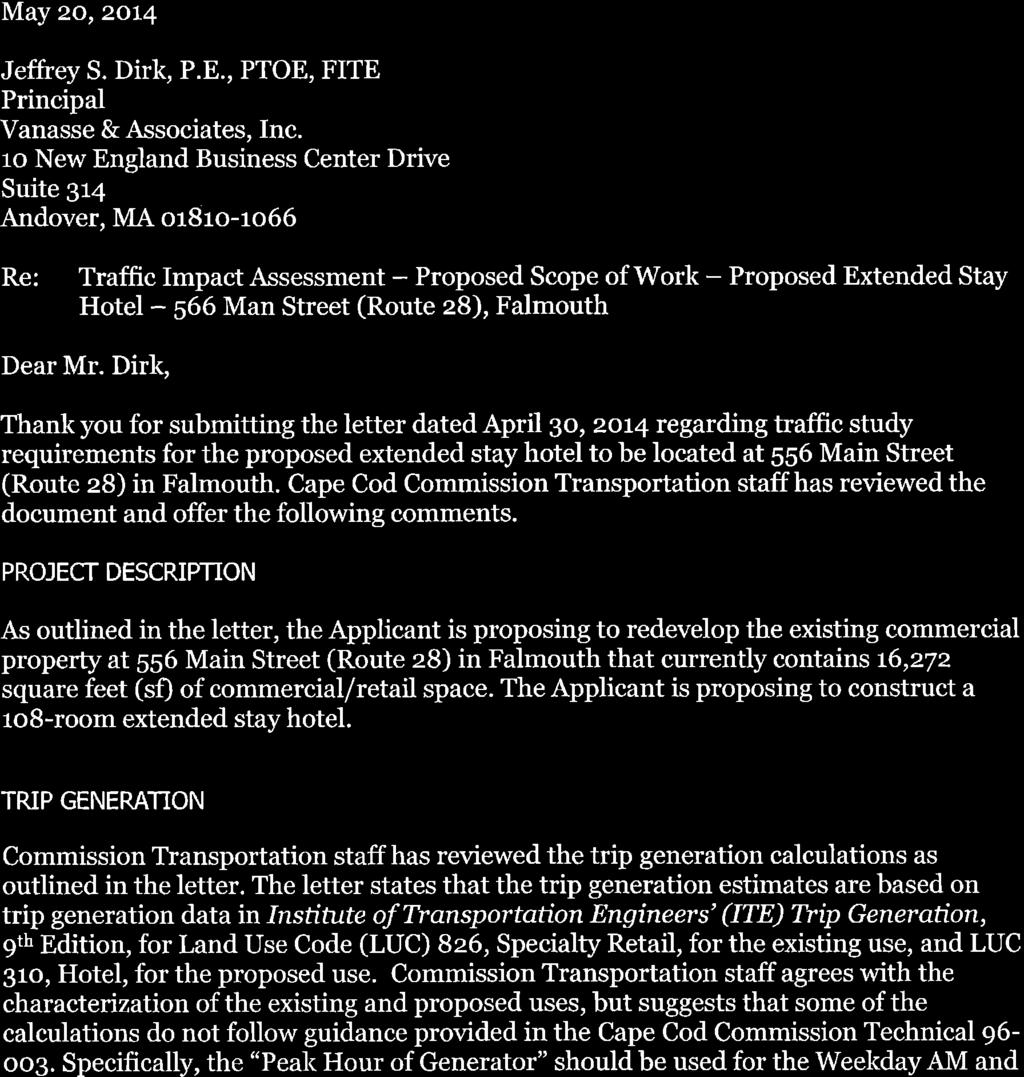
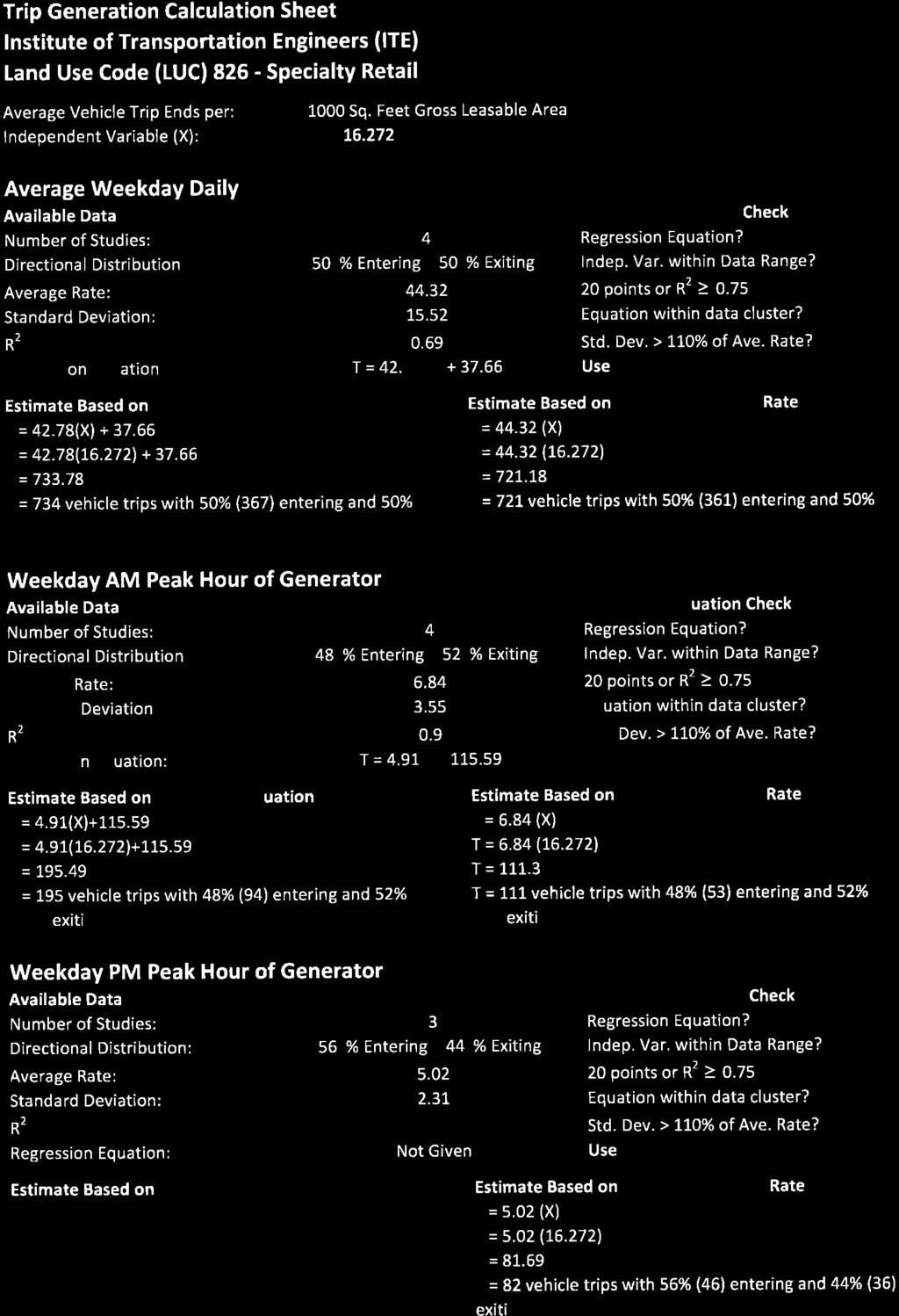
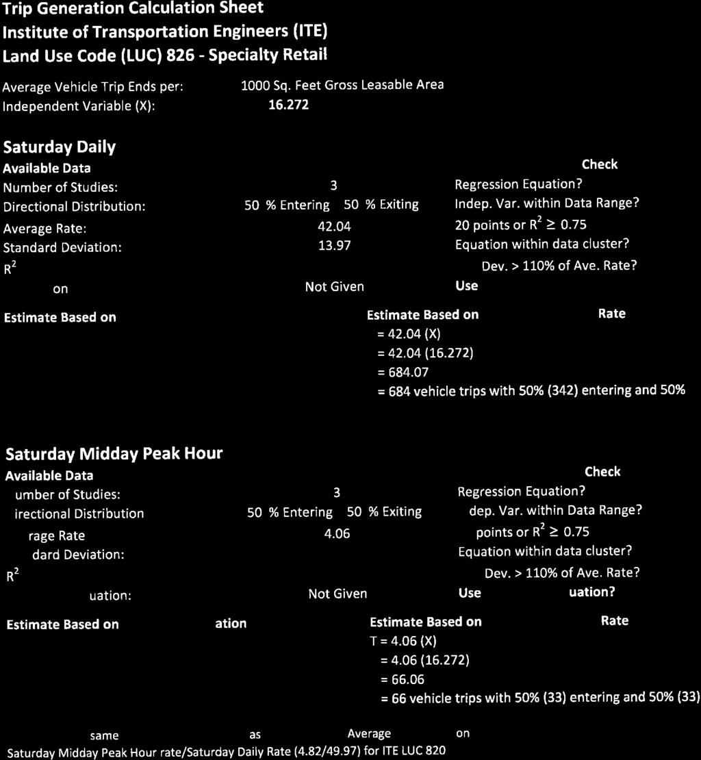
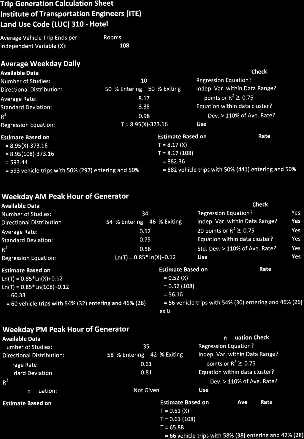
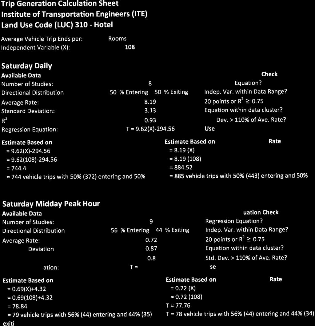
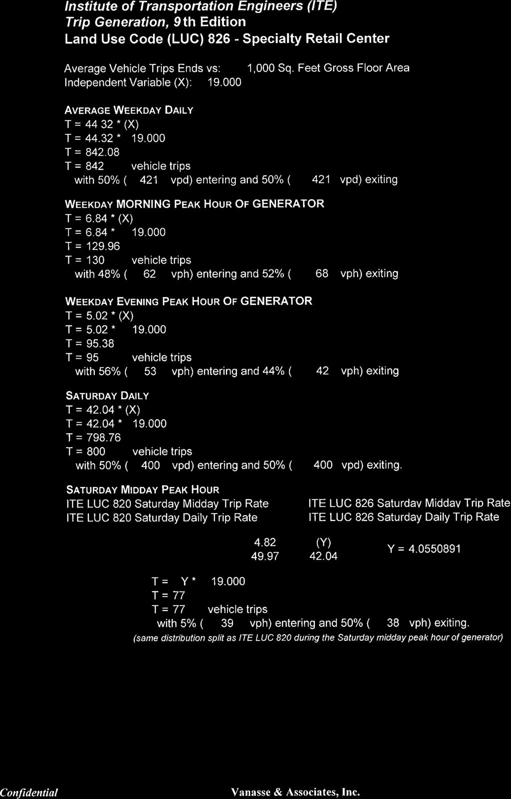
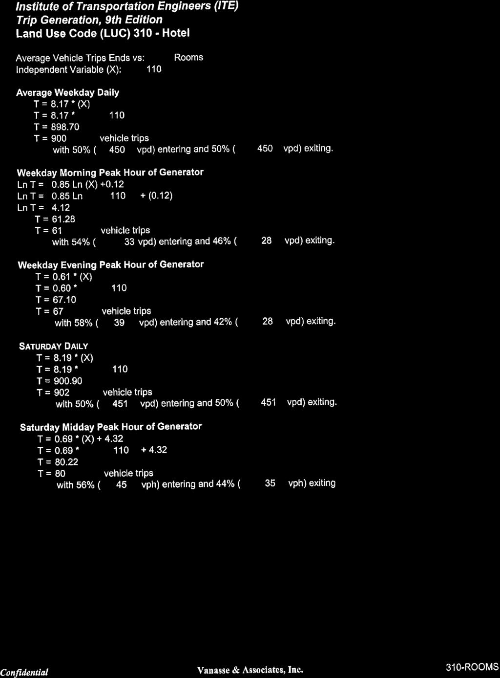
2 TRANSPORTATION Vanasse & Associates, Inc. (VAI) has completed a Transportation Impact Assessment (TIA) in support of this Application pursuant to Section 5 of the Cape Cod Commission Chapter A, Enabling Regulations Governing Review of Developments of Regional Impact (DRI), for a Limited DRI Review of a proposed extended stay hotel to be located at 556 Main Street (Route 28) in Falmouth, Massachusetts (the Project ). The purpose of this TIA is to provide sufficient information to allow the Cape Cod Commission (the Commission ) to make a finding that the Project meets the requirements for Limited DRI review with respect to Transportation and the goals and performance standards relative to Transportation as identified in the 2009 Cape Cod Regional Policy Plan as amended. The following details our findings with respect to the Project and its interface with the Transportation system. PROJECT DESCRIPTION The Project will entail the redevelopment of an existing commercial property located at 556 Main Street (Route 28) in Falmouth, Massachusetts, to accommodate a 110-room extended stay hotel with 121 parking spaces (86 on-site and 35 off-site at 19 Nye Road). The Project site is generally bounded by residential properties to the north; Main Street to the south; and commercial properties to the east and west; and currently contains approximately 16,272 square feet (sf) of commercial/retail space (antique store and ancillary storage space) that will be removed to accommodate the redevelopment of the Project site. Figure 1 depicts the Project site location in relation to the existing roadway network. Access to the Project site will be provided by way of Lantern Lane, a private way which bisects the Project site and intersects the north side of Main Street approximately 180 feet west of Nye Road. Lantern Lane will be reconstructed to accommodate the Project and will continue to provide access to the residential properties to the north of the Project site. Access to the off-site parking lot will be provided by way of a gated (key card activated) driveway that will intersect the west side of Nye Road approximately 190 feet south of Main Street. A sidewalk is provided along Nye Road that will be improved as a part of the Project and marked crosswalks are afforded at the Main Street/Nye Road intersection for hotel guests to cross Main Street between the Project site and the off-site parking lot. TRAFFIC CHARACTERISTICS The anticipated traffic characteristics of the Project were developed using trip-generation statistics published by the Institute of Transportation Engineers (ITE). 1 The ITE provides trip-generation information for various types of land uses developed as a result of scientific studies that have been conducted over the past 50 plus years. This information includes trip characteristics for uses similar to those that currently occupy the Project site, as well as for the proposed use. The traffic characteristics of the existing uses (antique store and ancillary storage space) were calculated using ITE Land Use Code (LUC) 826, Specialty Retail Center, and assuming 16,272 sf of space, 2 with those of the proposed use (extended stay hotel) calculated using LUC 310, Hotel, and following the guidance provided in the Cape Cod Commission Technical Bulletin Trip Generation, 9 th Edition; Institute of Transportation Engineers; Washington, DC; ITE LUC 820, Shopping Center, was also reviewed for use in developing the traffic characteristics of the existing uses and was determined to result in similar or higher trip estimates. G:\6668 Falmouth, MA\Limited DRI Application\Limited DRI Applciation - Transportation docx 1

3 Limited DRI Review Application - Proposed Extended Stay Hotel - Falmouth, Massachusetts FALMOUTH SITE Scale in Feet R:\6668\6668slm1.dwg, 7/1/2014 9:16:57 AM
4 Table 1 summarizes and compares the traffic characteristics of the current and proposed use of the Project site. Table MAIN STREET REDEVELOPMENT PROJECT EXISTING AND PROPOSED TRAFFIC VOLUME COMPARISON Time Period/Direction Average Weekday Daily: Entering Exiting Total Weekday Morning Peak-Hour of Generator: Entering Exiting Total Weekday Evening Peak-Hour of Generator: Entering Exiting Total Saturday Daily: Entering Exiting Total Saturday Midday Peak-Hour: Entering Exiting Total a Based on ITE LUC 310, Hotel; 110 rooms. b Based on ITE LUC 826, Specialty Retail; 16,272 sf. (A) Proposed Extended Stay Hotel (110 Rooms) a Vehicle Trips (B) Existing (C = A - B) Uses b Difference As can be seen in Table 1, the redevelopment of the Project site as an extended stay hotel is expected to result in 178 additional vehicle trips on an average weekday (two-way, 24-hour volume) when compared to the projected traffic characteristics of the existing uses that occupy the Project site, with 50 fewer vehicle trips predicted during the weekday morning peak-hour and 15 fewer vehicle trips predicted during the weekday evening peak-hour. On a Saturday, the redevelopment of the Project site is expected to result in 218 additional vehicle trips, with 14 additional vehicle trips predicted during the Saturday midday peak-hour. The detailed trip-generation calculations are attached. G:\6668 Falmouth, MA\Limited DRI Application\Limited DRI Applciation - Transportation docx 2
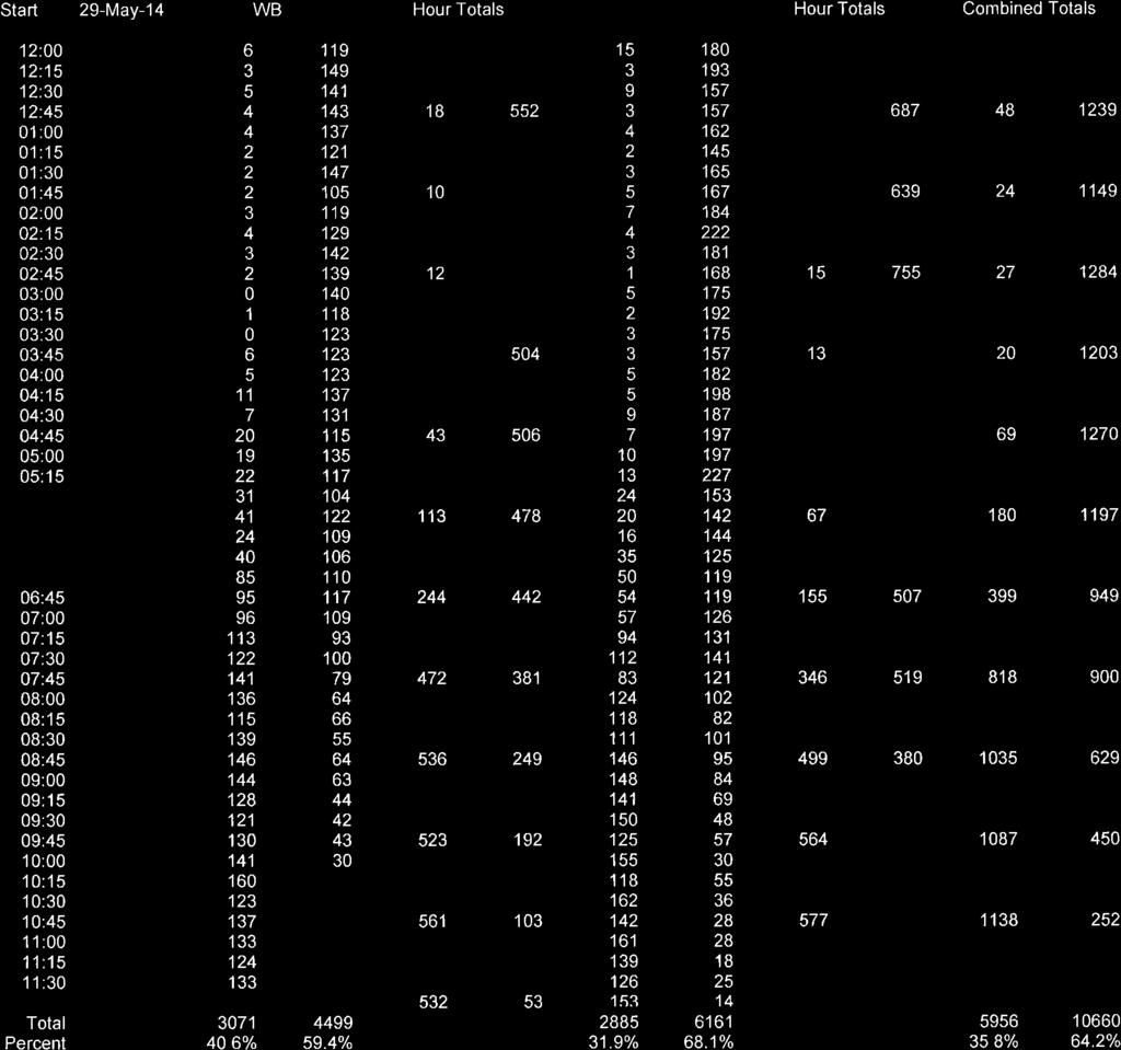
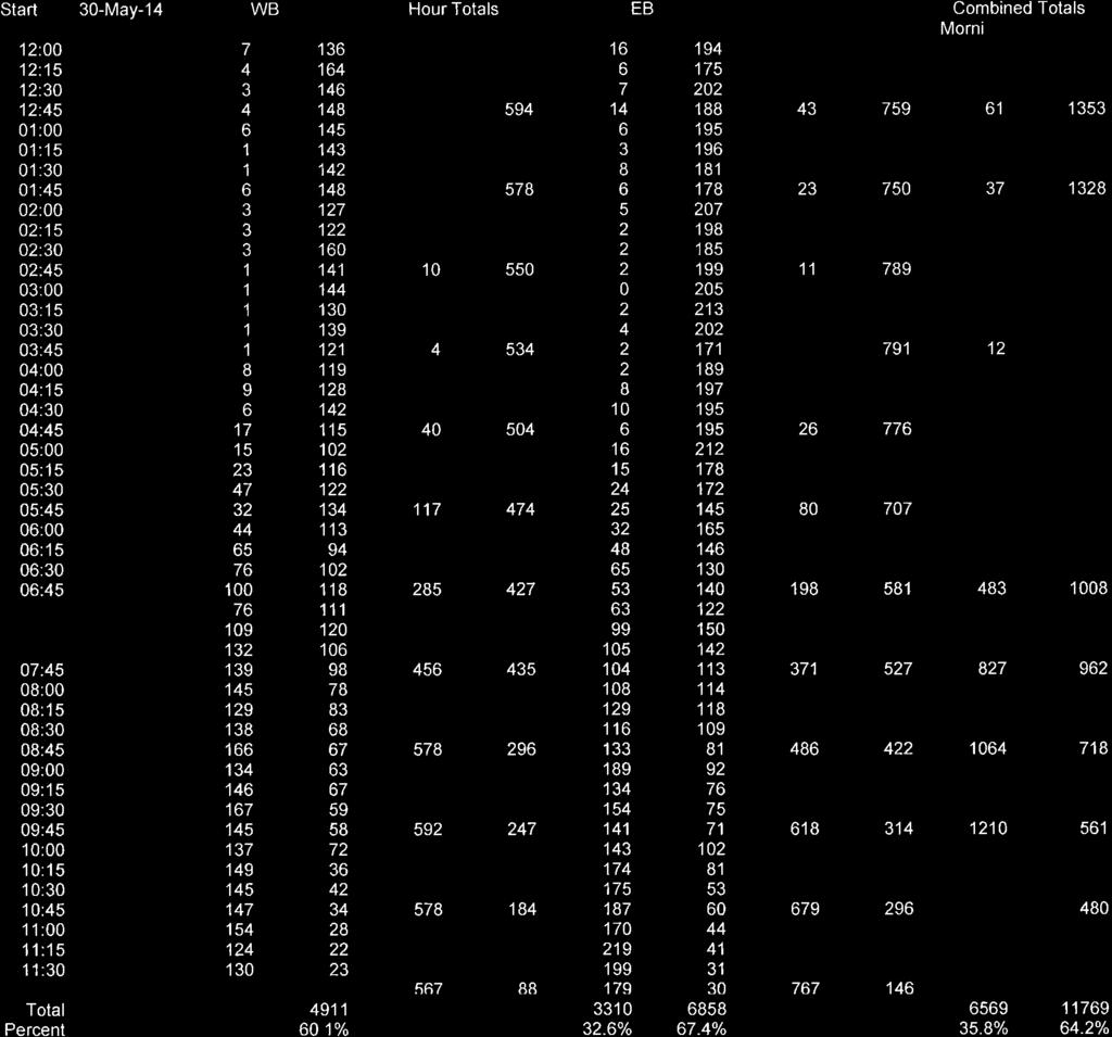
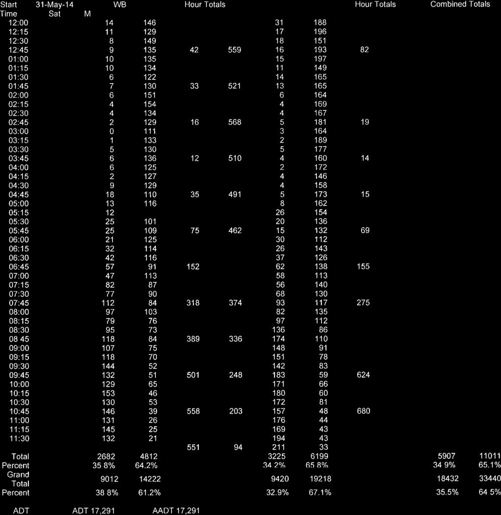
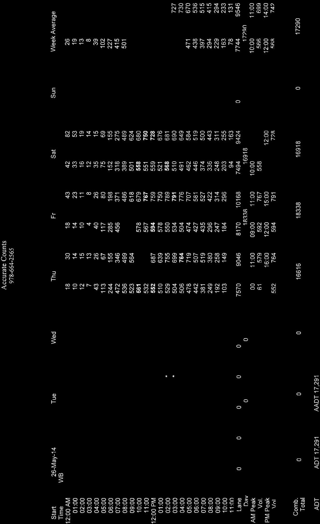
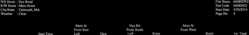
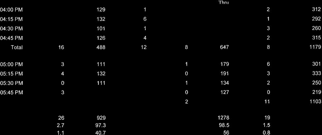
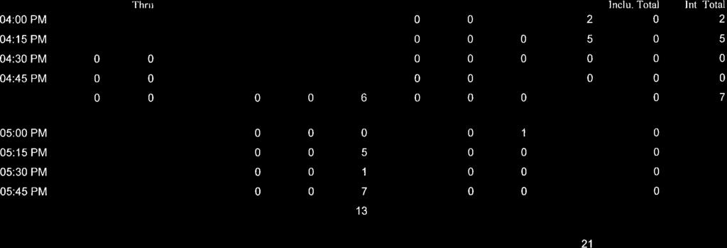
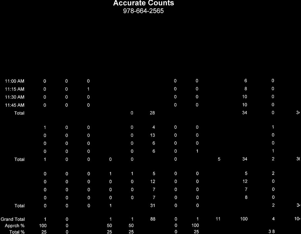
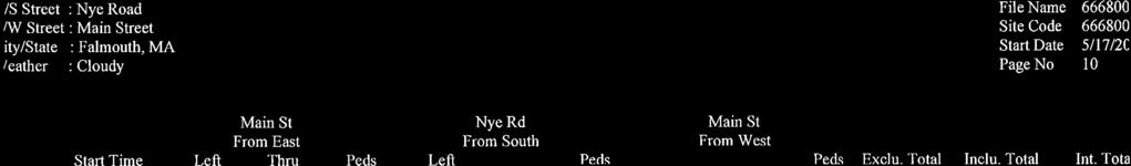
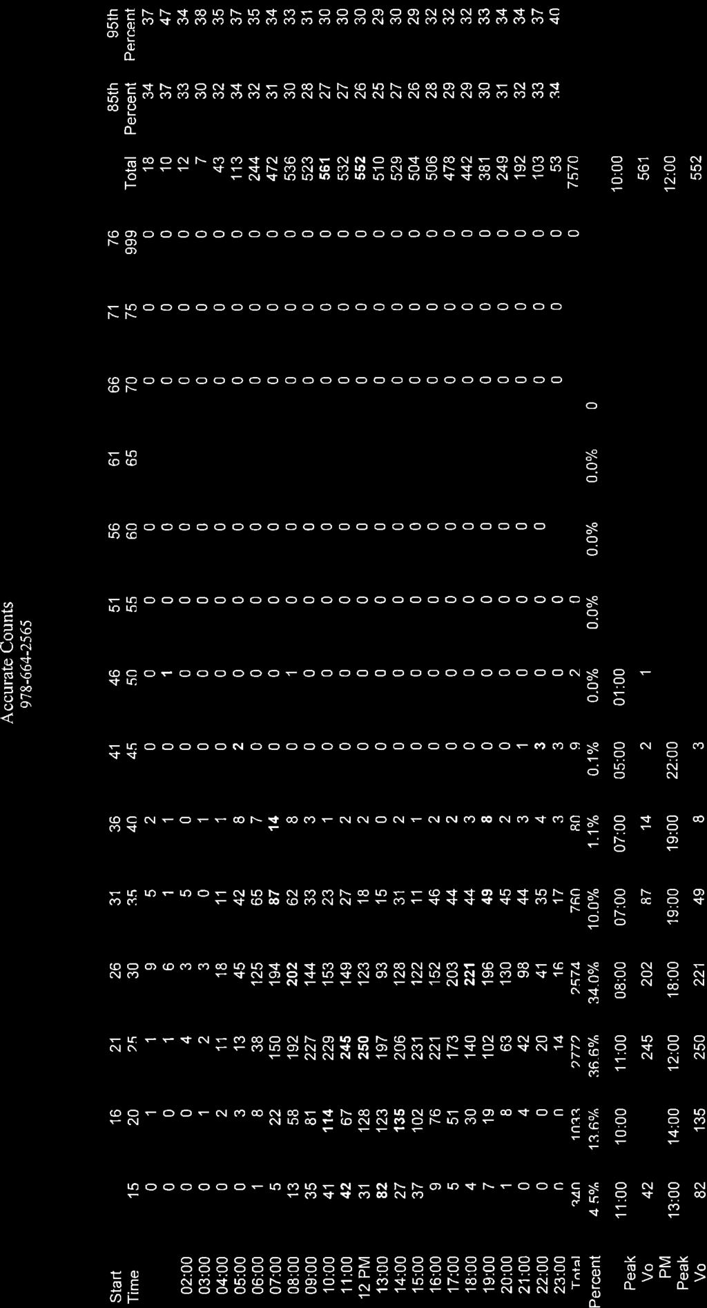
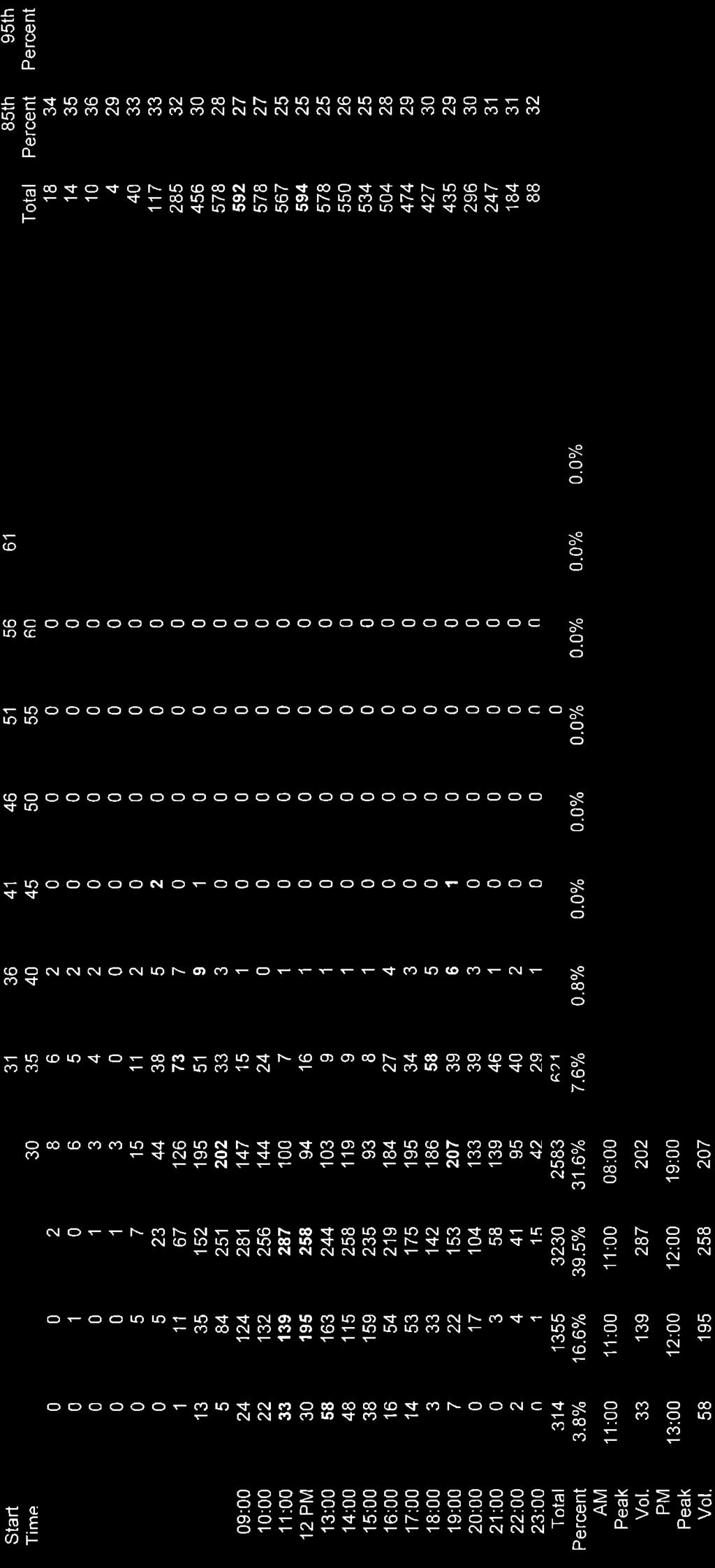
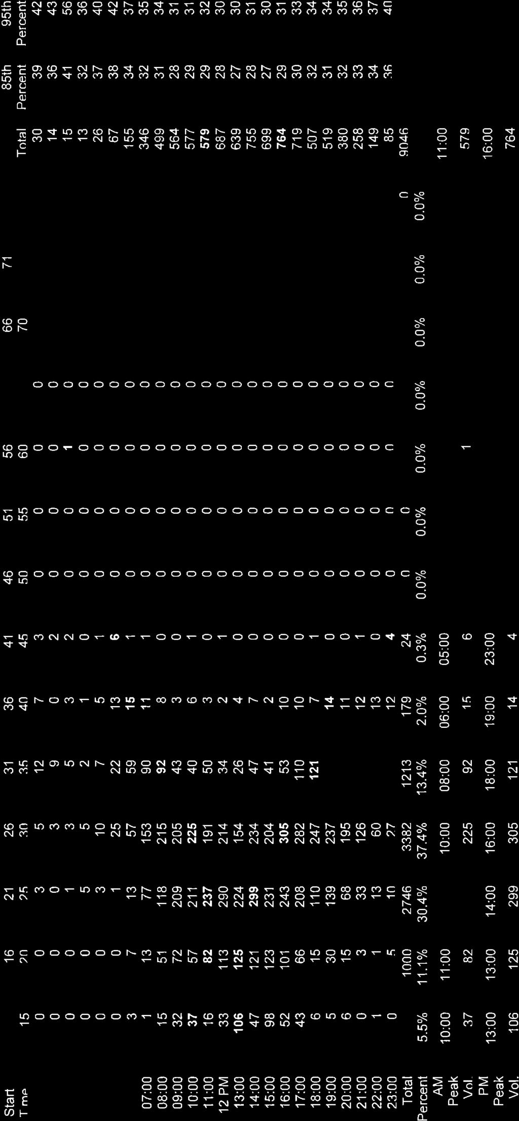
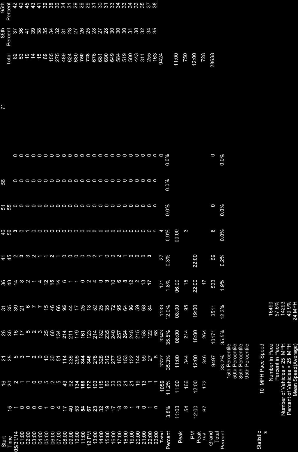
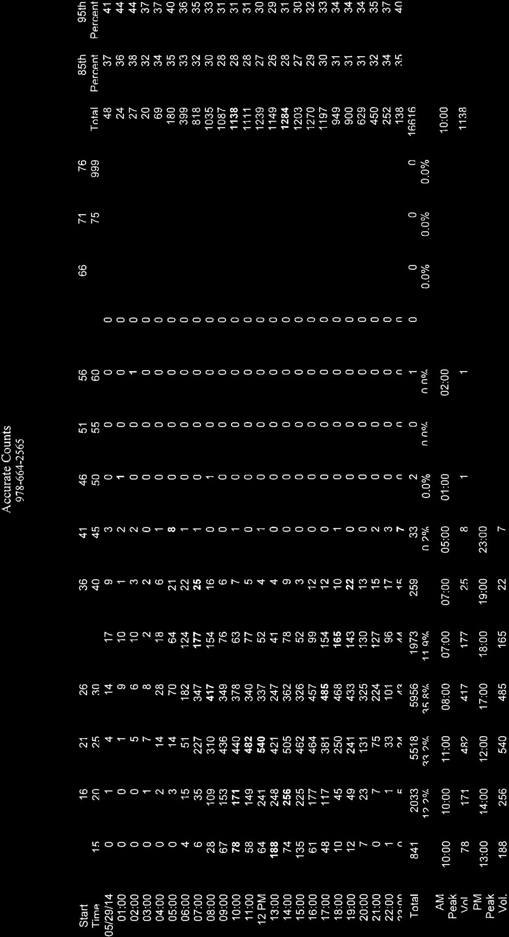
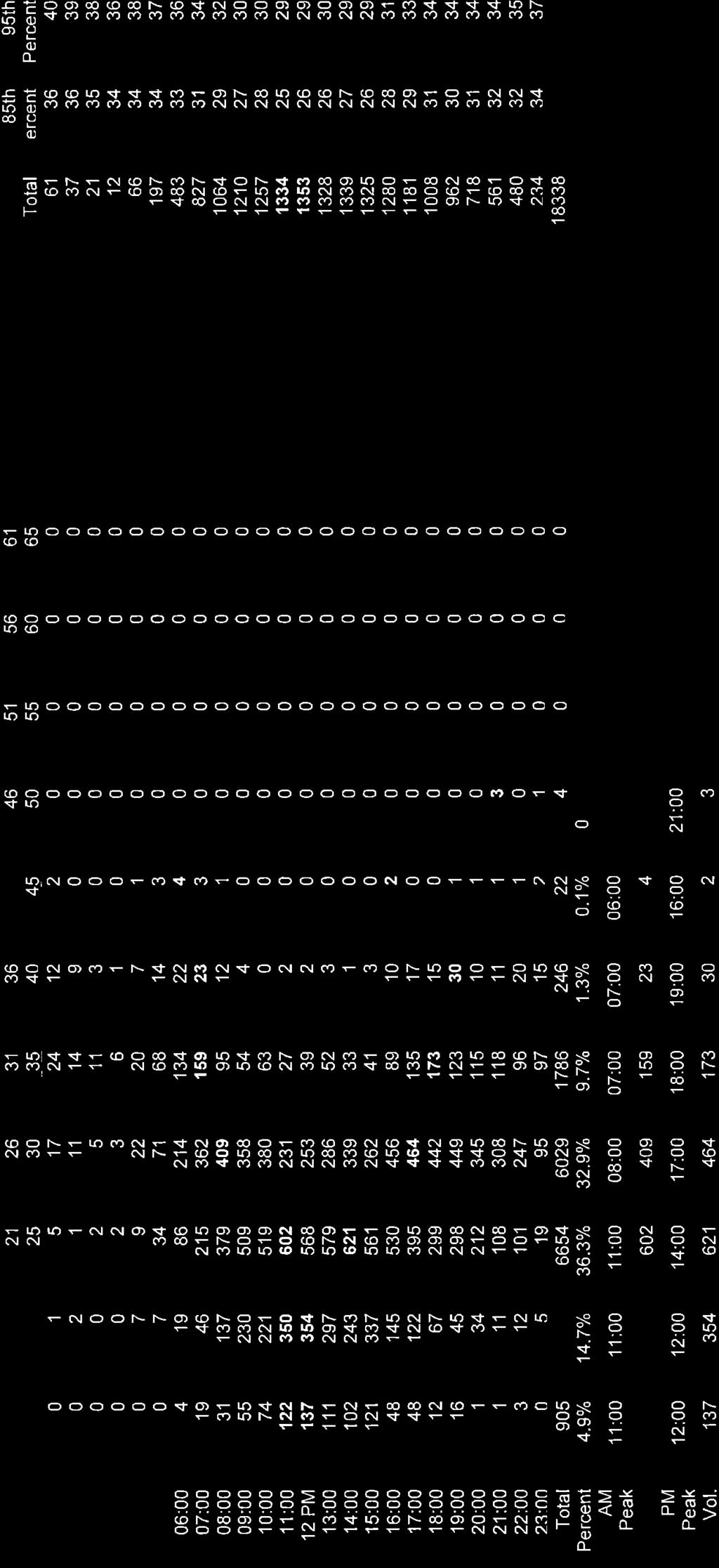
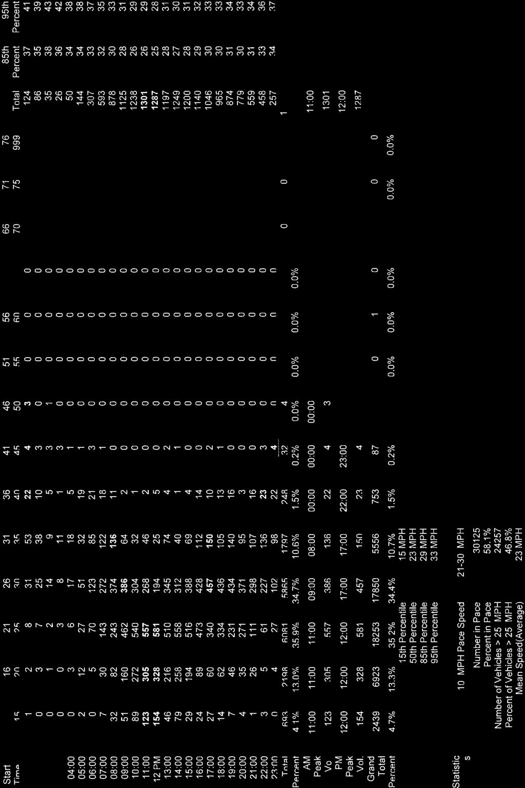
5 PROJECT SITE ACCESS EVALUATION As described previously, access to the Project site will be provided by way of Lantern Lane, a private way that bisects the Project site and intersects the north side of Main Street approximately 180 feet west of Nye Road. Lantern Lane will be reconstructed to accommodate the Project and will continue to provide access to the residential properties to the north of the Project site. Access to the off-site parking lot will be provided by way of a gated (key card activated) driveway that will intersect the west side of Nye Road approximately 190 feet south of Main Street. A sidewalk is provided along Nye Road that will be improved as a part of the Project and marked crosswalks are afforded at the Main Street/Nye Road intersection for hotel guests to cross Main Street between the Project site and the off-site parking lot. The following provides a description of the roadways that will provide access to the Project site and includes an assessment of sight lines at the Project site driveway intersections with both Main Street and Nye Road. Roadways Main Street Within the study area, Main Street (Route 28) is a two-lane, urban principal arterial roadway that is under Town jurisdiction and traverses the study area in a general east-west direction. In the vicinity of the Project site, Main Street provides two (2) travel lanes per direction that are approximately 15-feet in width and are separated by a double-yellow centerline with no marked shoulders provided. Four to eightfoot wide cement concrete sidewalks are provided continuously along both sides of Main Street with wheelchair ramps provided for crossing intersecting roadways and driveways. Formal bicycle accommodations are not provided along Main Street; however, the 15-foot wide travel lanes provide sufficient width to accommodate bicycle travel in a shared travelled-way configuration. 3 The posted speed limit along Main Street within the study area is 35 miles per hour (mph). Traffic volume and speed data collected in May 2014 on Main Street in the vicinity of the Project site reported the following data: Average Weekday Traffic: 16,600 vehicles per day Saturday Traffic: 16,900 vehicles Average Travel Speed: 23 mph 85 th Percentile Travel Speed: 29 mph Bus service is provided along Main Street by the Cape Cod Regional Transit Authority (CCRTA) by way of the SeaLine bus service and the Woods Hole Shuttle (WHOOSH trolley) (discussion follows). Land use along Main Street within the study area consists of the Project site and residential and commercial properties. Nye Road Nye Road is a two-lane local roadway that is under Town jurisdiction and traverses a general north-south direction between Main Street and Queen Street. Nye Road is approximately 18-feet in width and accommodates two-way travel with no marked centerline or shoulders provided. Four-foot wide cement or bituminous concrete sidewalks are provided along both sides of Nye Road. Formal bicycle accommodations are not provided along Nye Road; however, the low traffic volumes and travel speeds along this residential roadway are conducive to bicycle and motor vehicle travel within the travelled-way. A posted speed limit is not provided for Nye Road. Peak-hour traffic volumes measured in May A minimum width of 14-feet consisting of the travel lane and paved shoulder (where present) is required to support bicycle travel in a shared travelled-way configuration. G:\6668 Falmouth, MA\Limited DRI Application\Limited DRI Applciation - Transportation docx 3
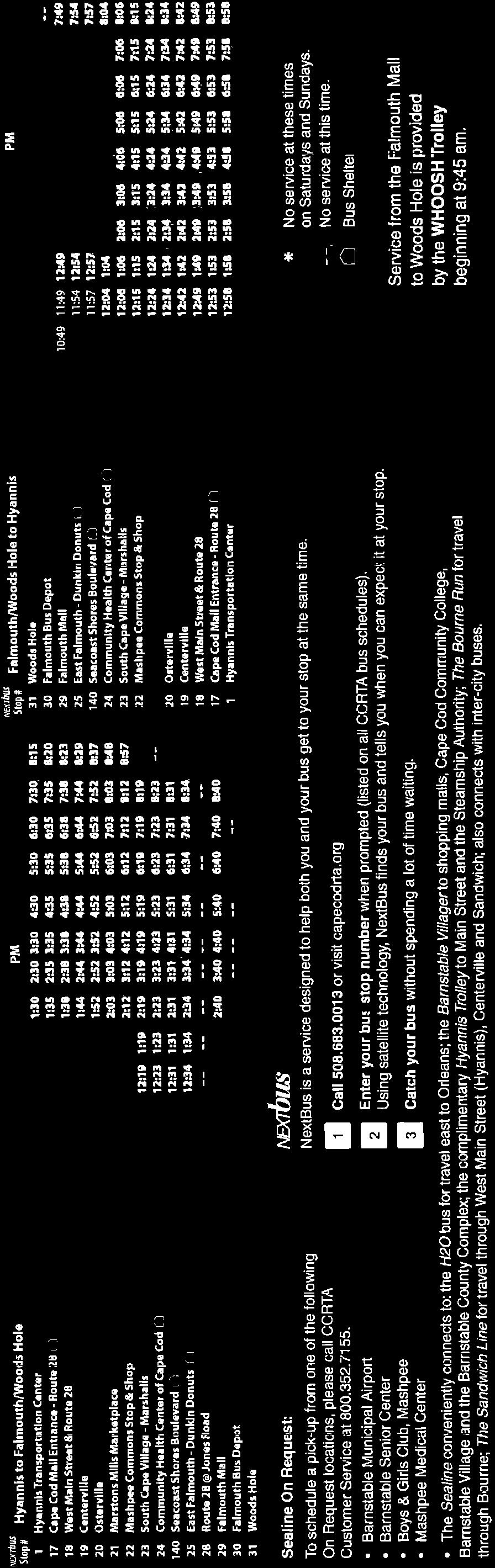
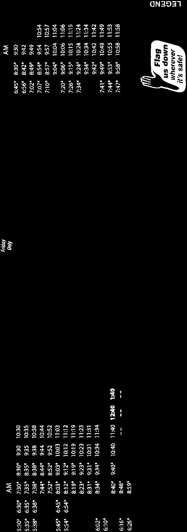
6 indicate that Nye Road accommodates approximately 45 vehicles per hour during both the weekday morning and evening peak hours, and approximately 30 vehicles per hour during the Saturday midday peak-hour. Land use along Nye Road consists of residential and commercial properties. Intersection Nye Road intersects Main Street from the south to form a three-legged intersection under STOP-sign control. The Main Street east and westbound approaches consist of a 15-foot wide general purpose travel lane with no marked shoulder provided. The directions of travel along Main Street are separated by a double-yellow centerline. Nye Road consists of an 18-foot wide roadway that accommodates two-way travel with no marked centerline or shoulders provided and vehicles approaching Main Street under STOP-sign control. Sidewalks are provided along both sides of the intersecting roadways, with marked crosswalks for crossing Nye Road and the Main Street west leg of the intersection. Pedestrian crossing warning signs are provided in advance of the crossing on Main Street. Land use in the vicinity of the intersection consists of the Project site and commercial properties. Public Transportation Services Public transportation services are provided to the Town of Falmouth by the Cape Cod Regional Transit Authority (CCRTA). Within the study area, the CCRTA operates the SeaLine bus service which will be available to both guests and employees of the Project. The SeaLine bus route travels along Route 28 and past the Project site from the Hyannis Transportation Center to the Woods Hole Ferry Terminal in Falmouth, with numerous local stops including: the Cape Cod Mall; Centerville; Osterville; Marstons Mills Marketplace; Mashpee Commons; South Cape Village; East Falmouth; the Falmouth Mall; and the Falmouth Bus Depot. Connections to other CCRTA bus routes and to regional bus service provided by Plymouth & Brockton (P&B) Street Railway Co. (service to Boston (South Station)) and Peter Pan Bus Lines (service to Providence and New York City) can be made at the Hyannis Transportation Center located in downtown Hyannis. During the summer, the SeaLine route terminates at the Falmouth Mall, with service between the Falmouth Mall and Woods Hole provided by trolley (the WHOOSH trolley). SeaLine service is provided Monday through Saturday, with 18 buses per day (nine in each direction); headways range from one to two hours. Fares for adults and youths are $2.00, with a $1.00 fare for senior citizens and people with disabilities. All CCRTA buses are handicapped and wheelchair accessible, and are equipped with bicycle racks. The Woods Hole Shuttle (WHOOSH trolley) operates seven days a week from mid-june through late- September and provides service between the Falmouth Mall and the Woods Hole Aquarium. Service is provided every half-hour on weekdays and hourly on weekends. The adult trolley fare is $1.00, with a $0.50 fare for senior citizens and people with disabilities. In addition to the fixed-route bus service, the CCRTA provides door-to-door bus service by way of the Dial-A-Ride Transportation (DART). DART service is provided by appointment to Cape Cod residents of all ages for trips of any purpose including school, work, shopping, medical visits, and visiting friends, and is provided in all 15 towns on Cape Cod. DART vehicles carry 19 passengers and have hydraulic lifts for people with disabilities. New subscribers must pre-enroll; once enrolled, reservations may be made up to one week in advance. DART service is generally provided between 7:00 AM and 7:00 PM Monday through Friday; between 9:00 AM and 7:00 PM on Saturday; and between 9:00 AM to 1:00 PM on Sunday. Fares for adults and youths is $3.00, with a $1.50 fare for seniors and people with disabilities; children five and younger ride for free when accompanied by a paying adult. G:\6668 Falmouth, MA\Limited DRI Application\Limited DRI Applciation - Transportation docx 4
7 Sight Distance Evaluation Sight distance measurements were performed at the Project site driveway/lantern Lane intersection with Main Street in accordance with MassDOT and American Association of State Highway and Transportation Officials (AASHTO) 4 standards. Both stopping sight distance (SSD) and intersection sight distance (ISD) measurements were performed. In brief, SSD is the distance required by a vehicle traveling at the design speed of a roadway, on wet pavement, to stop prior to striking an object in its travel path. ISD or corner sight distance (CSD) is the sight distance required by a driver entering or crossing an intersecting roadway to perceive an on-coming vehicle and safely complete a turning or crossing maneuver with on-coming traffic. In accordance with AASHTO standards, at a minimum, sufficient SSD should be provided at an intersection. ISD, while desirable to maintain efficient traffic flow, is not required for an intersection to function in a safe manner. As discussed previously, vehicle travel speed measurements were performed along Main Street in the vicinity of the Project site over a continuous 72-hour period (Thursday through Saturday) in May Based on these measurements, the average observed travel speed was found to be 23 mph and the 85 th percentile vehicle travel speed was found to be 29 mph, or 5 mph below the posted speed limit along this section of Main Street (35 mph). The 85 th percentile speed is used as the basis of engineering design and in the evaluation of sight distances. That being said, given that the measured 85 th percentile vehicle travel speed was found to be below the posted speed limit, the posted speed limit (35 mph) was used to assess sight lines at the Project site driveway intersection. Table 2 presents the measured SSD and ISD at the subject intersection. Table 2 SIGHT DISTANCE MEASUREMENTS a Feet Intersection/Sight Distance Measurement Recommended Minimum (SSD) Desirable (ISD) b Measured Main Street at the Project Site Driveway/Lantern Lane Stopping Sight Distance: Main Street approaching from the east Main Street approaching from the west Intersection Sight Distance: Looking to the east from the Project site driveway/lantern Lane Looking to the west from the Project site driveway/lantern Lane / / a Recommended minimum values obtained from: A Policy on Geometric Design of Highways and Streets, 6 th Edition; American Association of State Highway and Transportation Officials (AASHTO); 2011; and based on an approach speed of 35 mph along Main Street. b Value shown is the intersection sight distance for a vehicle turning left/right exiting a roadway under STOP control such that motorists approaching the intersection on the major street should not need to adjust their travel speed to less than 70 percent of their initial approach speed. 4 A Policy on Geometric Design of Highways and Streets, 6 th Edition; American Association of State Highway and Transportation Officials (AASHTO); G:\6668 Falmouth, MA\Limited DRI Application\Limited DRI Applciation - Transportation docx 5
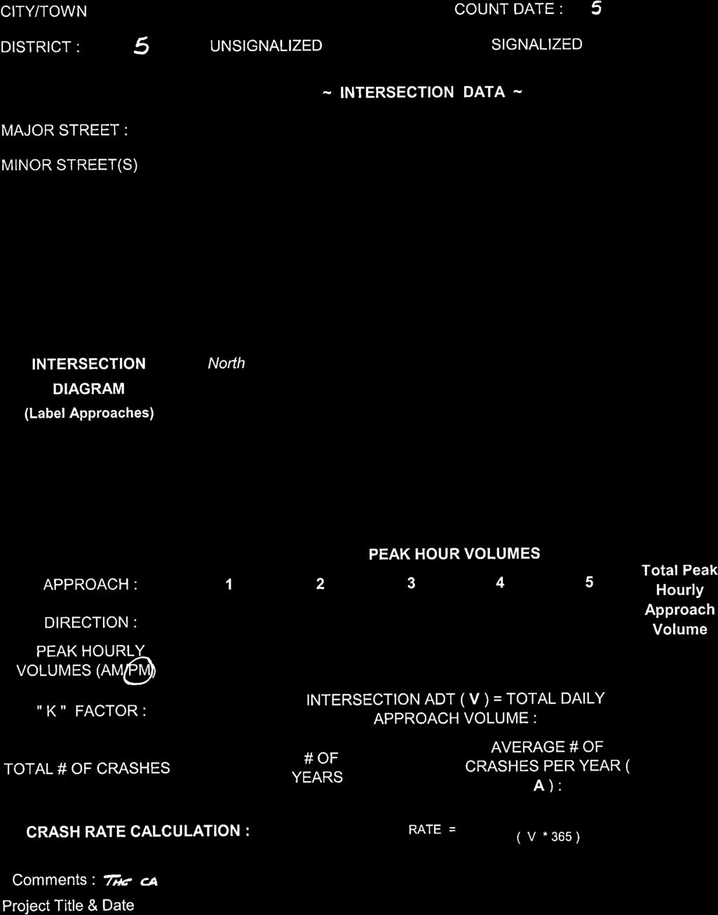
8 As can be seen in Table 2, lines of sight at the Project site driveway/lantern Lane intersection with Main Street meet or exceed the recommended minimum sight distance (SSD) to function in a safe manner based on a 35 mph approach speed along Main Street, which is consistent with the posted speed limit and 6 mph above the measured 85 th percentile travel speed (29 mph). Lines of sight to and from the driveway that will serve the proposed overflow parking lot on Nye Road will meet or exceed 155 feet, the minimum sight distance required for a 25 mph approach speed, which is consistent with the residential setting of the abutting land use and the relatively low volume of traffic using the roadway. MOTOR VEHICLE CRASH ANALYSIS Motor vehicle crash information for the study area intersections was provided by the MassDOT Highway Division Safety Management/Traffic Operations Unit for the most recent three-year period available (2010 through 2012, inclusive) in order to examine motor vehicle crash trends occurring within the study area. Based on a review of this data, no motor vehicle crashes were reported to have occurred at the Main Street/Lantern Lane intersection. Three (3) motor vehicle crashes were reported at or in the vicinity of the Main Street/Nye Road intersection over the three-year review period, or approximately one (1) crash per year, none of which were reported to have involved a pedestrian or bicyclist. Of the three (3) reported crashes, two (2) involved property damage only; two (2) were reported a rear-end type collisions; and all three (3) crashes occurred on dry pavement. No roadway defects were noted as a contributing cause in any of the reported crashes; all were attributed to driver error or inattentiveness. The calculated motor vehicle crash rate for the Main Street/Nye Road intersection per million entering vehicles is 0.20, which is below both the MassDOT statewide and District 5 (the MassDOT Highway Division District in which the intersection is located) average crash rates for an unsignalized intersection of 0.60 and 0.58 crashes per million entering vehicles, respectively. The detailed MassDOT Crash Rate Worksheet is attached. Based on a review of the MassDOT motor vehicle crash data, no inherent safety deficiencies were noted with respect to the design or operation of the Main Street/Lantern Lane or Main Street/Nye Road intersections. SUMMARY VAI has completed a Transportation Impact Assessment in support of this Application pursuant to Section 5 of the Cape Cod Commission Chapter A, Enabling Regulations Governing Review of Developments of Regional Impact (DRI), for a Limited DRI Review of a proposed extended stay hotel to be located at 556 Main Street (Route 28) in Falmouth, Massachusetts. This assessment has provided relevant information and analyses to support a finding by the Cape Cod Commission that the Project meets the requirements for Limited DRI review with respect to Transportation and the goals and performance standards relative to Transportation as identified in the 2009 Cape Cod Regional Policy Plan as amended. Based on the information prepared as a part of this assessment, the following has been concluded with respect to the Project: 1. The redevelopment of the Project site as an extended stay hotel is expected to result in 178 additional vehicle trips on an average weekday (two-way, 24-hour volume) when compared to the projected traffic characteristics of the existing uses that occupy the Project site, with 50 fewer vehicle trips predicted during the weekday morning peak-hour and 15 fewer vehicle trips predicted during the weekday evening peak-hour. On a Saturday, the redevelopment of the G:\6668 Falmouth, MA\Limited DRI Application\Limited DRI Applciation - Transportation docx 6
9 Project site is expected to result in 218 additional vehicle trips, with 14 additional vehicle trips predicted during the Saturday midday peak-hour; 2. Both Main Street and Nye Road provide pedestrian and bicycle accommodations that currently exist or will be improved as a part of the Project to safely convey patrons, guests and employees to and from the Project site and the overflow parking lot; 3. Public transportation services provided by the CCRTA are available to the Project site; 4. Lines of sight to and from the Project site driveway on Main Street (Lantern Lane) and for the overflow parking lot on Nye Road meet, exceed or will be made to meet or exceed the required minimum sight distance to function in a safe manner based on the appropriate approach speed along these roadways (35 mph along Main Street and 25 mph along Nye Road); and 5. No inherent safety deficiencies were noted with respect to the design or operation of Main Street proximate to the Project site or the Main Street/Nye Road intersection based on a review of motor vehicle crash data provided by MassDOT. In consideration of the above and presuming a favorable finding by the Commission granting Limited DRI review with respect to Transportation, the Applicant will work with Commission Transportation Staff with respect to the design of the Project site driveway and other such measures as deemed appropriate to: i) mitigate the projected impact of the Project on the regional roadway network serving the Project locus; and ii) afford safe and convenient access to the Project site for all roadway users. G:\6668 Falmouth, MA\Limited DRI Application\Limited DRI Applciation - Transportation docx 7
10 Limited DRI Review Scoping Checklist Redevelopment/Change of Use - Transportation The following summarizes the guidance provided in the Limited DRI Review Scoping Checklist relative to Transportation as this guidance relates to the Project. Congestion Management Guidance: Response: Will the Project generate more than 250 new daily trips? No. The Project is expected to generate 178 new daily vehicle trips on an average weekday and 218 new vehicle trips on a Saturday when compared to the existing uses that occupy the Project site. Transportation Balance and Efficiency Guidance: Response: Will the Project generate more than 250 new daily trips? No. The Project is expected to generate 178 new daily vehicle trips on an average weekday and 218 new vehicle trips on a Saturday when compared to the existing uses that occupy the Project site. Safety Guidance: Response: Does the Project have direct access on or does the Project directly abut a regional roadway? Yes. The Project site has direct access to and directly abuts Main Street (Route 28), a regional roadway under the jurisdiction of the Town of Falmouth. Safety Guidance: Response: Will the Project generate more than 25 new peak hour trips at a high crash location? No. The Project is predicted to generate 14 new vehicle trips during the Saturday midday peak-hour (traffic volume hour with the highest predicted traffic volume increase). G:\6668 Falmouth, MA\Limited DRI Application\Limited DRI Applciation - Transportation docx
11 ATTACHMENTS AUTOMATIC TRAFFIC RECORDER COUNTS MANUAL TURNING MOVEMENT COUNTS VEHICLE TRAVEL SPEED MEASUREMENTS TRIP-GENERATION CALCULATIONS CCRTA BUS ROUTE, SCHEDULE AND FARE INFORMATION MASSDOT CRASH RATE WORKSHEET G:\6668 Falmouth, MA\Limited DRI Application\Limited DRI Applciation - Transportation docx
12 AUTOMATIC TRAFFIC RECORDER COUNTS G:\6668 Falmouth, MA\Limited DRI Application\Limited DRI Applciation - Transportation docx
13
14
15
16
17 MANUAL TURNING MOVEMENT COUNTS G:\6668 Falmouth, MA\Limited DRI Application\Limited DRI Applciation - Transportation docx
18
19
20
21
22
23
24
25
26

27
28
29
30
31
32
33
34
35
36
37
38
39
40
41
42
43
44
45
46
47
48 VEHICLE TRAVEL SPEED MEASUREMENTS G:\6668 Falmouth, MA\Limited DRI Application\Limited DRI Applciation - Transportation docx
49

50

51
52

53
54
55
56
57
58 TRIP-GENERATION CALCULATIONS G:\6668 Falmouth, MA\Limited DRI Application\Limited DRI Applciation - Transportation docx

59
60
61
62
63
64
65
66
67 CCRTA BUS ROUTE, SCHEDULE AND FARE INFORMATION G:\6668 Falmouth, MA\Limited DRI Application\Limited DRI Applciation - Transportation docx

68
69
70 MASSDOT CRASH RATE WORKSHEET G:\6668 Falmouth, MA\Limited DRI Application\Limited DRI Applciation - Transportation docx

71

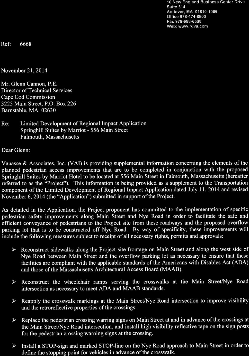
72 10 New England Business Center Drive Suite 314 Andover, MA Office Fax Web: Ref: 6668 November 20, 2014 Mr. Glenn Cannon, P.E. Director of Technical Services Cape Cod Commission 3225 Main Street, P.O. Box 226 Barnstable, MA Re: Limited Development of Regional Impact Application Springhill Suites by Marriot Main Street Falmouth, Massachusetts Dear Glenn: Vanasse & Associates, Inc. (VAI) is providing supplemental information in support of the Limited Development of Regional Impact Application dated July 11, 2014 and revised November 6, 2014 (the Application ) for the proposed Springhill Suites by Marriot Hotel to be located at 556 Main Street in Falmouth, Massachusetts (hereafter referred to as the Project ). Specifically, VAI is providing updated trip-generation calculations for the existing buildings that currently occupy the Project site. As presented in the Application, the Project site is currently occupied by 19,000± square feet (sf) of commercial buildings that include an antique store and ancillary storage and warehouse space; however, the trip-generation calculations that were presented in the Application reflected 16,272 sf of existing commerical space. In order to correct this discrepancy, the traffic characteristics of the existing uses that were presened in Table 1 of the Transportation component of the Application were revised to reflect 19,000 sf of commercial space using Institute of Transportation Engineers (ITE) 1 Land Use Code (LUC) 826, Specialty Retail Center, 2 consitent with the methodology presented therein. The traffic characteristics of the Project (extended stay hotel) did not change from the values that were presented in the Application. Table 1R provides an updated summary and comparison of the traffic characteristics of the Proejct to those of the existing uses that occupy the Proejct site (19,000± sf of commercial space conisting of an antique store and ancillary storage and warehouse space) 1 Trip Generation, 9 th Edition; Institute of Transportation Engineers; Washington, DC; ITE LUC 820, Shopping Center, was also reviewed for use in developing the traffic characteristics of the existing uses and was determined to result in similar or higher trip estimates.
73 Mr. Glenn Cannon, P.E. November 20, 2014 Page 2 of 3 Table 1R 566 MAIN STREET REDEVELOPMENT PROJECT EXISTING AND PROPOSED TRAFFIC VOLUME COMPARISON Time Period/Direction Average Weekday Daily: Entering Exiting Total Weekday Morning Peak-Hour of Generator: Entering Exiting Total Weekday Evening Peak-Hour of Generator: Entering Exiting Total Saturday Daily: Entering Exiting Total Saturday Midday Peak-Hour: Entering Exiting Total a Based on ITE LUC 310, Hotel; 110 rooms. b Based on ITE LUC 826, Specialty Retail; 19,000 sf. (A) Proposed Extended Stay Hotel (110 Rooms) a Vehicle Trips (B) Existing (C = A - B) Uses b Difference As can be seen in Table 1R, the redevelopment of the Project site as an extended stay hotel (Springhill Suites by Marriot) is expected to result in 58 additional vehicle trips on an average weekday (two-way, 24-hour volume) when compared to the projected traffic characteristics of the existing uses that occupy the Project site, with 69 fewer vehicle trips predicted during the weekday morning peak-hour and 28 fewer vehicle trips predicted during the weekday evening peak-hour. On a Saturday, the redevelopment of the Project site is expected to result in 102 additional vehicle trips, with 3 additional vehicle trips predicted during the Saturday midday peak-hour. The detailed trip-generation calculations are attached. G:\6668 Falmouth, MA\Limited DRI Application\G. Cannon docx
74
75 ATTACHMENT TRIP-GENERATION CALCULATIONS G:\6668 Falmouth, MA\Limited DRI Application\G. Cannon docx
76 TRIP-GENERATION CALCULATIONS G:\6668 Falmouth, MA\Limited DRI Application\G. Cannon docx
77
78

79

80
2.0 Development Driveways. Movin Out June 2017
 Movin Out June 2017 1.0 Introduction The proposed Movin Out development is a mixed use development in the northeast quadrant of the intersection of West Broadway and Fayette Avenue in the City of Madison.
Traffic, Transportation & Civil Engineering Ali R. Khorasani, P.E. P.O. Box 804, Spencer, MA 01562, Tel: (508)
") Associates Traffic, Transportation & Civil Engineering Ali R. Khorasani, P.E. P.O. Box 804, Spencer, MA 01562, Tel: (508) 885-5121 Ms. Teri Ford, Associate 800 Boylston Street, Suite 1570 Boston, MA July
Associates Traffic, Transportation & Civil Engineering Ali R. Khorasani, P.E. P.O. Box 804, Spencer, MA 01562, Tel: (508) 885-5121 Ms. Teri Ford, Associate 800 Boylston Street, Suite 1570 Boston, MA July
Section 5.0 Traffic Information
 Section 5.0 Traffic Information 10.0 TRANSPORTATION MDM Transportation Consultants, Inc. (MDM) has prepared an evaluation of transportation impacts for the proposed evaluation for the expansion of the
Traffic Engineering Study
 Traffic Engineering Study Bellaire Boulevard Prepared For: International Management District Technical Services, Inc. Texas Registered Engineering Firm F-3580 November 2009 Executive Summary has been requested
appendix 4: Parking Management Study, Phase II
 appendix 4: Parking Management Study, Phase II A4-1 A4-2 Eastlake Parking Management Study Final Phase 2 Report Future Parking Demand & Supply January 6, 2017 Submitted by Denver Corp Center III 7900 E.
Woods Hole - Falmouth Trolley SUMMER 2018
 CAPE COD'S PUBLIC TRANSIT SYSTEM Woods Hole - Falmouth Trolley SUMMER 2018 June 23, 2018 through September 3, 2018 Hyannis Transportation Center Pick-up/drop-off area located at Main and Center Street.
TRAFFIC IMPACT ANALYSIS
 TRAFFIC IMPACT ANALYSIS Emerald Isle Commercial Development Prepared by SEPI Engineering & Construction Prepared for Ark Consulting Group, PLLC March 2016 I. Executive Summary A. Site Location The Emerald
1. INTRODUCTION 2. PROJECT DESCRIPTION CUBES SELF-STORAGE MILL CREEK TRIP GENERATION COMPARISON
 CUBES SELF-STORAGE MILL CREEK TRIP GENERATION COMPARISON 1. INTRODUCTION This report summarizes traffic impacts of the proposed CUBES Self-Storage Mill Creek project in comparison to the traffic currently
EXECUTIVE SUMMARY. The following is an outline of the traffic analysis performed by Hales Engineering for the traffic conditions of this project.
 EXECUTIVE SUMMARY This study addresses the traffic impacts associated with the proposed Shopko redevelopment located in Sugarhouse, Utah. The Shopko redevelopment project is located between 1300 East and
Transportation Land Development Environmental S e r v i c e s
 Transportation Land Development Environmental S e r v i c e s Memorandum To: Ms. Kristin E. Kassner Planning Director Town Hall Annex 25 Center Street Burlington, MA 01803 Date: September 23, 2013 Project
Proposed Lowe s Home Improvement Center
 Traffic Impact and Access Study Proposed Lowe s Home Improvement Center Dennis, Massachusetts Prepared for Prepared by Lowe s Home Centers, Inc. 1605 Curtis Bridge Road Wilkesboro, North Carolina 28697
THE CORNERSTONE APARTMENTS TRAFFIC IMPACT STUDY R&M PROJECT NO
 THE CORNERSTONE APARTMENTS SITUATED AT N/E/C OF STAUDERMAN AVENUE AND FOREST AVENUE VILLAGE OF LYNBROOK NASSAU COUNTY, NEW YORK TRAFFIC IMPACT STUDY R&M PROJECT NO. 2018-089 September 2018 50 Elm Street,
BARRHAVEN FELLOWSHIP CRC 3058 JOCKVALE ROAD OTTAWA, ONTARIO TRANSPORTATION BRIEF. Prepared for:
 BARRHAVEN FELLOWSHIP CRC 3058 JOCKVALE ROAD OTTAWA, ONTARIO TRANSPORTATION BRIEF Prepared for: Barrhaven Fellowship CRC 3058 Jockvale Road Ottawa, ON K2J 2W7 December 7, 2016 116-649 Report_1.doc D. J.
Traffic Generation November 28, Mr. Todd Baker Baker Properties, LLC 953 Islington Street Suite 23D Portsmouth, NH 03801
 28-1932-03 November 28, 2016 Mr. Todd Baker Baker Properties, LLC 953 Islington Street Suite 23D Portsmouth, NH 03801 Re: Traffic Impact Evaluation The Rose Farm Residential Development Exeter, New Hampshire
Trip Generation Study: Provo Assisted Living Facility Land Use Code: 254
 Trip Generation Study: Provo Assisted Living Facility Land Use Code: 254 Introduction The Brigham Young University Institute of Transportation Engineers (BYU ITE) student chapter completed a trip generation
TRAFFIC IMPACT ANALYSIS FOR THE 630/650 SOUTH STREET RETAIL DEVELOPMENT WRENTHAM, MASSACHUSETTS
 PARE PROJECT NO. 17120.00 REPORT TRAFFIC IMPACT ANALYSIS FOR THE 630/650 SOUTH STREET RETAIL DEVELOPMENT WRENTHAM, MASSACHUSETTS SUBMITTED TO: GEORGETOWN CAPITAL MANAGEMENT PO BOX 369 GEORGETOWN, MA 01833
Construction Realty Co.
 MEMORANDUM TO: FROM : Jeff Pickus Construction Realty Co. Luay R. Aboona, PE Principal 9575 West Higgins Road, Suite 400 Rosemont, Illinois 60018 p: 847-518-9990 f: 847-518-9987 DATE: May 22, 2014 SUBJECT:
TRAFFIC SIGNAL DESIGN REPORT KING OF PRUSSIA ROAD & RAIDER ROAD RADNOR TOWNSHIP PENNSYLVANIA
 TRAFFIC SIGNAL DESIGN REPORT KING OF PRUSSIA ROAD & RAIDER ROAD RADNOR TOWNSHIP PENNSYLVANIA PREPARED FOR: UNIVERSITY OF PENNSYLVANIA HEALTH SYSTEM 34 CIVIC CENTER BOULEVARD PHILADELPHIA, PA 1987 (61)
King Soopers #116 Thornton, Colorado
 Traffic Impact Study King Soopers #116 Thornton, Colorado Prepared for: Galloway & Company, Inc. T R A F F I C I M P A C T S T U D Y King Soopers #116 Thornton, Colorado Prepared for Galloway & Company
Address Land Use Approximate GSF
 M E M O R A N D U M To: Kara Brewton, From: Nelson\Nygaard Date: March 26, 2014 Subject: Brookline Place Shared Parking Analysis- Final Memo This memorandum presents a comparative analysis of expected
Traffic Impact Study Speedway Gas Station Redevelopment
 Traffic Impact Study Speedway Gas Station Redevelopment Warrenville, Illinois Prepared For: Prepared By: April 11, 2018 Table of Contents 1. Introduction... 1 2. Existing Conditions... 4 Site Location...
Downtown Lee s Summit Parking Study
 Downtown Lee s Summit Parking Study As part of the Downtown Lee s Summit Master Plan, a downtown parking and traffic study was completed by TranSystems Corporation in November 2003. The parking analysis
BROWARD BOULEVARD CORRIDOR TRANSIT STUDY
 BROWARD BOULEVARD CORRIDOR TRANSIT STUDY FM # 42802411201 EXECUTIVE SUMMARY July 2012 GOBROWARD Broward Boulevard Corridor Transit Study FM # 42802411201 Executive Summary Prepared For: Ms. Khalilah Ffrench,
RICHMOND OAKS HEALTH CENTRE 6265 PERTH STREET OTTAWA, ONTARIO TRANSPORTATION BRIEF. Prepared for: Guycoki (Eastern) Limited.
 Limited.") RICHMOND OAKS HEALTH CENTRE 6265 PERTH STREET OTTAWA, ONTARIO TRANSPORTATION BRIEF Prepared for: Guycoki (Eastern) Limited June 16, 2016 116-638 Brief_1.doc D. J. Halpenny & Associates Ltd. Consulting
RICHMOND OAKS HEALTH CENTRE 6265 PERTH STREET OTTAWA, ONTARIO TRANSPORTATION BRIEF Prepared for: Guycoki (Eastern) Limited June 16, 2016 116-638 Brief_1.doc D. J. Halpenny & Associates Ltd. Consulting
Appendix J Traffic Impact Study
 MRI May 2012 Appendix J Traffic Impact Study Level 2 Traffic Assessment Limited Impact Review Appendix J [This page was left blank intentionally.] www.sgm-inc.com Figure 1. Site Driveway and Trail Crossing
TRAFFIC IMPACT STUDY. USD #497 Warehouse and Bus Site
 TRAFFIC IMPACT STUDY for USD #497 Warehouse and Bus Site Prepared by: Jason Hoskinson, PE, PTOE BG Project No. 16-12L July 8, 216 145 Wakarusa Drive Lawrence, Kansas 6649 T: 785.749.4474 F: 785.749.734
Traffic Impact Analysis West Street Garden Plots Improvements and DuPage River Park Garden Plots Development Naperville, Illinois
 Traffic Impact Analysis West Street Garden Plots Improvements and DuPage River Park Garden Plots Development Naperville, Illinois Submitted by April 9, 2009 Introduction Kenig, Lindgren, O Hara, Aboona,
Citizens Committee for Facilities
 Citizens Committee for Facilities AGENDA Thursday, December 11, 2014 City Council Chambers 305 3 rd Avenue East -Twin Falls, Idaho 11:30 A.M. AGENDA ITEMS Purpose By 1. Discussion and possible action on
RE: 67/71 Marquette Avenue Redevelopment Transportation Overview
 1223 Michael Street, Suite 100, Ottawa, Ontario K1J 7T2 Tel: 613.738.4160 Fax: 613.739.7105 www.delcan.com April 23, 2014 OUR REF: TO3157TOA00 BY EMAIL: mark.larose@urbanrisedevelopment.com Urban Rise
TABLE OF CONTENTS 1.0 INTRODUCTION AND SUMMARY Purpose of Report and Study Objectives... 2
 TABLE OF CONTENTS 1.0 INTRODUCTION AND SUMMARY 1 1.1 Purpose of Report and Study Objectives... 2 1.2 Executive Summary... 3 1.2.1 Site Location and Study Area... 3 1.2.2 Development Description... 3 1.2.3
TRAFFIC IMPACT ANALYSIS. for MILTON SQUARE
 TRAFFIC IMPACT ANALYSIS for MILTON SQUARE US Route 7 Milton, Vermont March 5, 2008 LAMOUREUX & DICKINSON 14 Morse Drive Essex Junction, Vermont 05452 (802) 878-4450 Traffic Impact Assessment EXECUTIVE
CHAPTER 9: VEHICULAR ACCESS CONTROL Introduction and Goals Administration Standards
 9.00 Introduction and Goals 9.01 Administration 9.02 Standards 9.1 9.00 INTRODUCTION AND GOALS City streets serve two purposes that are often in conflict moving traffic and accessing property. The higher
November 1, Mr. Jafar Tabrizi President, Tabrizi Rugs 180 Bedford Highway. Traffic Impact Statement BH-1 and BH-2, Southgate Drive, Bedford, NS
 161-12598 Mr. Jafar Tabrizi President, Tabrizi Rugs 180 Bedford Highway Bedford, NS B4A 1C1 [Via Email: tabrizi@tabrizi.com] RE: Traffic Impact Statement Dear Mr. Tabrizi: Plans are being prepared for
ANDERSON PROPERTY SITE ANALYSIS
 ANDERSON PROPERTY SITE ANALYSIS Introduction The Montgomery County Department of Transportation (MCDOT) initiated a feasibility study in the fall of 2012 to evaluate the need for transit service expansion
IMPROVEMENT CONCEPTS
 IMPROVEMENT CONCEPTS for the South Novato Transit Hub Study Prepared by: January 11, 2010 DKS Associates With Wilbur Smith Associates IMPROVEMENT CONCEPTS Chapter 1: Introduction 1. INTRODUCTION The strategic
Proposed CVS/pharmacy
 Traffic Impact and Access Study Proposed CVS/pharmacy West Main Street (Route 1) at Hull Street Clinton, Connecticut PREPARED FOR Arista Development LLC 520 Providence Highway, Suite 9 Norwood, Massachusetts
Speed Limit and Safety Nexus Studies for Automated Enforcement Locations in the District of Columbia 3rd Street Tunnel at Massachusetts Avenue Exit
 Speed Limit and Safety Nexus Studies for Automated Enforcement Locations in the District of Columbia 3rd Street Tunnel at Massachusetts Avenue Exit Study Area and Location District PSA Ward ANC Phase Description
LAWRENCE TRANSIT CENTER LOCATION ANALYSIS 9 TH STREET & ROCKLEDGE ROAD / 21 ST STREET & IOWA STREET LAWRENCE, KANSAS
 LAWRENCE TRANSIT CENTER LOCATION ANALYSIS 9 TH STREET & ROCKLEDGE ROAD / 21 ST STREET & IOWA STREET LAWRENCE, KANSAS TRAFFIC IMPACT STUDY FEBRUARY 214 OA Project No. 213-542 TABLE OF CONTENTS 1. INTRODUCTION...
INDUSTRIAL DEVELOPMENT
 INDUSTRIAL DEVELOPMENT Traffic Impact Study Plainfield, Illinois August 2018 Prepared for: Seefried Industrial Properties, Inc. TABLE OF CONTENTS Executive Summary 2 Introduction 3 Existing Conditions
Craig Scheffler, P.E., PTOE HNTB North Carolina, P.C. HNTB Project File: Subject
 TECHNICAL MEMORANDUM To Kumar Neppalli Traffic Engineering Manager Town of Chapel Hill From Craig Scheffler, P.E., PTOE HNTB North Carolina, P.C. Cc HNTB Project File: 38435 Subject Obey Creek TIS 2022
TRAFFIC PARKING ANALYSIS
 TRAFFIC PARKING ANALYSIS NAPA FLEA MARKET COUNTY OF NAPA Prepared for: Tom Harding Napa-Vallejo Flea Market 33 Kelly Road American Canyon, CA 9453 Prepared by: 166 Olympic Boulevard, Suite 21 Walnut Creek,
APPENDIX C1 TRAFFIC ANALYSIS DESIGN YEAR TRAFFIC ANALYSIS
 APPENDIX C1 TRAFFIC ANALYSIS DESIGN YEAR TRAFFIC ANALYSIS DESIGN YEAR TRAFFIC ANALYSIS February 2018 Highway & Bridge Project PIN 6754.12 Route 13 Connector Road Chemung County February 2018 Appendix
Trip Generation and Parking Study New Californian Apartments, Berkeley
 Trip Generation and Parking Study New Californian Apartments, Berkeley Institute of Transportation Engineers University of California, Berkeley Student Chapter Spring 2012 Background The ITE Student Chapter
Re: 233 Armstrong Street Residential Condominium Traffic Brief
 1223 Michael Street, Suite 100, Ottawa, ON K1J 7T2 Tel: 613.738.4160 Fax: 613.739.7105 www.delcan.com August 8, 2008 TO3031TOP00 BY E-MAIL: gerry.lalonde@rogers.com Spencedale Properties 7 Cobb Court Ottawa,
5. OPPORTUNITIES AND NEXT STEPS
 5. OPPORTUNITIES AND NEXT STEPS When the METRO Green Line LRT begins operating in mid-2014, a strong emphasis will be placed on providing frequent connecting bus service with Green Line trains. Bus hours
MERIVALE PRIORITY SQUARE 2852 MERIVALE ROAD CITY OF OTTAWA TRANSPORTATION BRIEF. Prepared for: ONT Inc. 25 Winding Way Nepean, Ontario K2C 3H1
 MERIVALE PRIORITY SQUARE 2852 MERIVALE ROAD CITY OF OTTAWA TRANSPORTATION BRIEF Prepared for: 2190986ONT Inc. 25 Winding Way Nepean, Ontario K2C 3H1 October 6, 2010 110-502 Report_1.doc D. J. Halpenny
Escondido Marriott Hotel and Mixed-Use Condominium Project TRAFFIC IMPACT ANALYSIS REPORT
 Escondido Marriott Hotel and Mixed-Use Condominium Project TRAFFIC IMPACT ANALYSIS REPORT Prepared for Phelps Program Management 420 Sixth Avenue, Greeley, CO 80632 Prepared by 5050 Avenida Encinas, Suite
Trip Generation & Parking Occupancy Data Collection: Grocery Stores Student Chapter of Institute of Transportation Engineers at UCLA Spring 2014
 Trip Generation & Parking Occupancy Data Collection: Grocery Stores Student Chapter of Institute of Transportation Engineers at UCLA Spring 2014 Page 1 Introduction The UCLA Institute of Transportation
Trip and Parking Generation Study of the Peaks Ice Arena
 Trip and Parking Generation Study of the Peaks Ice Arena Introduction The Brigham Young University Institute of Transportation Engineers student chapter (BYU ITE) completed a trip and parking generation
Table 1 - Land Use Comparisons - Proposed King s Wharf Development. Retail (SF) Office (SF) 354 6,000 10, Land Uses 1
 Office (SF) 354 6,000 10, Land Uses 1") Ref. No. 171-6694 Phase 2 November 23, 217 Mr. David Quilichini, Vice President Fares & Co. Developments Inc. 31 Place Keelson Sales Centre DARTMOUTH NS B2Y C1 Sent Via Email to David@faresinc.com RE:
Ref. No. 171-6694 Phase 2 November 23, 217 Mr. David Quilichini, Vice President Fares & Co. Developments Inc. 31 Place Keelson Sales Centre DARTMOUTH NS B2Y C1 Sent Via Email to David@faresinc.com RE:
Traffic Feasibility Study
 Traffic Feasibility Study Town Center South Robbinsville Township, Mercer County, New Jersey December 19, 2017 Prepared For Robbinsville Township Department of Community Development 2298 Route 33 Robbinsville,
Traffic Impact Statement (TIS)
") Traffic Impact Statement (TIS) Vincentian PUDA Collier County, FL 10/18/2013 Prepared for: Global Properties of Naples Prepared by: Trebilcock Consulting Solutions, PA 2614 Tamiami Trail N, Suite 615 1205
Traffic Impact Statement (TIS) Vincentian PUDA Collier County, FL 10/18/2013 Prepared for: Global Properties of Naples Prepared by: Trebilcock Consulting Solutions, PA 2614 Tamiami Trail N, Suite 615 1205
APPENDIX B Traffic Analysis
 APPENDIX B Traffic Analysis Rim of the World Unified School District Reconfiguration Prepared for: Rim of the World School District 27315 North Bay Road, Blue Jay, CA 92317 Prepared by: 400 Oceangate,
DEVELOPMENT PROPERTY 1627 MAXIME STREET CITY OF OTTAWA TRANSPORTATION OVERVIEW. Prepared for: Subhas Bhargava. July 9, Overview_1.
 DEVELOPMENT PROPERTY 1627 MAXIME STREET CITY OF OTTAWA TRANSPORTATION OVERVIEW Prepared for: Subhas Bhargava July 9, 2015 115-620 Overview_1.doc D. J. Halpenny & Associates Ltd. Consulting Transportation
Revised Report. Traffic Study for Safeway Fuel Center at Washington Square Shopping Center. In The City of Petaluma.
 Revised Report Traffic Study for Safeway Fuel Center at Washington Square Shopping Center In The Pleasanton Fresno Sacramento Santa Rosa TJKM www.tjkm.com Revised Report Traffic Study for Safeway Fuel
Study Area and Location District PSA Ward ANC Phase Description C Planned Suitland Parkway Westbound at Stanton Road Southeast
 Speed Limit and Safety Nexus Studies for Automated Enforcement Locations in the District of Columbia Suitland Parkway at Stanton Road SE Study Area and Location District PSA Ward ANC Phase Description
GASOLINE SERVICE STATION 1618, 1622 ROGER STEVENS DRIVE OTTAWA, ONTARIO TRANSPORTATION IMPACT ASSESSMENT. Prepared for:
 GASOLINE SERVICE STATION 1618, 1622 ROGER STEVENS DRIVE OTTAWA, ONTARIO TRANSPORTATION IMPACT ASSESSMENT Prepared for: Invecta Development (Ottawa) Corporation 758 Shanks Height Milton, ON L9T 7P7 May
MILLERSVILLE PARK TRAFFIC IMPACT ANALYSIS ANNE ARUNDEL COUNTY, MARYLAND
 MILLERSVILLE PARK TRAFFIC IMPACT ANALYSIS ANNE ARUNDEL COUNTY, MARYLAND Prepared for: Department of Public Works Anne Arundel County Prepared by: URS Corporation 4 North Park Drive, Suite 3 Hunt Valley,
RE: A Traffic Impact Statement for a proposed development on Quinpool Road
 James J. Copeland, P.Eng. GRIFFIN transportation group inc. 30 Bonny View Drive Fall River, NS B2T 1R2 May 31, 2018 Ellen O Hara, P.Eng. Project Engineer DesignPoint Engineering & Surveying Ltd. 200 Waterfront
Lacey Gateway Residential Phase 1
 Lacey Gateway Residential Phase Transportation Impact Study April 23, 203 Prepared for: Gateway 850 LLC 5 Lake Bellevue Drive Suite 02 Bellevue, WA 98005 Prepared by: TENW Transportation Engineering West
This letter summarizes our observations, anticipated traffic changes, and conclusions.
 Mr. David Jorschumb Project Manager Boulder Valley School District Re: Review of proposed school access improvements at the Foothills Elementary School in Boulder Dear Mr. Jorschumb, At your request, the
APPENDIX E. Traffic Analysis Report
 APPENDIX E Traffic Analysis Report THIS PAGE INTENTIONALLY BLANK EAGLE RIVER TRAFFIC MITIGATION PHASE I OLD GLENN HIGHWAY/EAGLE RIVER ROAD INTERSECTION IMPROVEMENTS TRAFFIC ANALYSIS Eagle River, Alaska
Table Existing Traffic Conditions for Arterial Segments along Construction Access Route. Daily
 5.8 TRAFFIC, ACCESS, AND CIRCULATION This section describes existing traffic conditions in the project area; summarizes applicable regulations; and analyzes the potential traffic, access, and circulation
POLICY FOR THE ESTABLISHMENT AND POSTING OF SPEED LIMITS ON COUNTY AND TOWNSHIP HIGHWAYS WITHIN MCHENRY COUNTY, ILLINOIS
 POLICY FOR THE ESTABLISHMENT AND POSTING OF SPEED LIMITS ON COUNTY AND TOWNSHIP HIGHWAYS WITHIN MCHENRY COUNTY, ILLINOIS MCHENRY COUNTY DIVISION OF TRANSPORTATION 16111 NELSON ROAD WOODSTOCK, IL 60098
TRAFFIC IMPACT ANALYSIS SHORTBREAD LOFTS 2009 MODIFICATION Chapel Hill, North Carolina
 TRAFFIC IMPACT ANALYSIS SHORTBREAD LOFTS 2009 MODIFICATION Chapel Hill, North Carolina Prepared for: The Town of Chapel Hill, NC Prepared by: Architects-Engineers-Planners, Inc. November 2009 Traffic Impact
Traffic Impact Study for the proposed. Town of Allegany, New York. August Project No Prepared For:
 Appendix B SRF Traffic Study (Revised November 2005) Draft Environmental Impact Statement University Commons Town of Allegany, Cattaraugus County, NY December 2005 Traffic Impact Study for the proposed
MONTEREY BAY AQUARIUM RESEARCH INSTITUTE (MBARI) MASTER PLAN UPDATE MOSS LANDING, CALIFORNIA
 MASTER PLAN UPDATE MOSS LANDING, CALIFORNIA") MONTEREY BAY AQUARIUM RESEARCH INSTITUTE (MBARI) MASTER PLAN UPDATE MOSS LANDING, CALIFORNIA TRAFFIC IMPACT ANALYSIS Administrative Draft Report Prepared For Monterey Bay Aquarium Research Institute Moss
MONTEREY BAY AQUARIUM RESEARCH INSTITUTE (MBARI) MASTER PLAN UPDATE MOSS LANDING, CALIFORNIA TRAFFIC IMPACT ANALYSIS Administrative Draft Report Prepared For Monterey Bay Aquarium Research Institute Moss
FFY Transportation Improvement Program (TIP) Development
 Development") FFY 2016-2019 Transportation Improvement Program (TIP) Development MAY 18, 2015 CAPE COD METROPOLITAN PLANNING ORGANIZATION Highway Funding Regional s Year STP HSIP CMAQ FFY 2016 2019 TOTAL Regional with
FFY 2016-2019 Transportation Improvement Program (TIP) Development MAY 18, 2015 CAPE COD METROPOLITAN PLANNING ORGANIZATION Highway Funding Regional s Year STP HSIP CMAQ FFY 2016 2019 TOTAL Regional with
Clean Harbors Canada, Inc.
 Clean Harbors Canada, Inc. Proposed Lambton Landfill Expansion Environmental Assessment Terms of Reference Transportation Assessment St. Clair Township, Ontario September 2009 itrans Consulting Inc. 260
NEWCASTLE MIDDLE SCHOOL Traffic Impact Analysis
 Gibson Traffic Consultants 2802 Wetmore Avenue Suite 220 Everett, WA 98201 425.339.8266 NEWCASTLE MIDDLE SCHOOL Traffic Impact Analysis Prepared for: Renton School District Jurisdiction: City of Newcastle
Transportation & Traffic Engineering
 Transportation & Traffic Engineering 1) Project Description This report presents a summary of findings for a Traffic Impact Analysis (TIA) performed by A+ Engineering, Inc. for the Hill Country Family
Memorandum. To: Sue Polka, City Engineer, City of Arden Hills. From: Sean Delmore, PE, PTOE. Date: June 21, 2017
 Memorandum engineering planning environmental construction 701 Xenia Avenue South Suite 300 Minneapolis, MN 55416 Tel: 763-541-4800 Fax: 763-541-1700 To: Sue Polka, City Engineer, City of Arden Hills From:
King Street & Wyman Road Transportation Impact Study & Transportation Demand Management. Paradigm Transportation Solutions Limited
 King Street & Wyman Road Transportation Impact Study & Transportation Demand Management Paradigm Transportation Solutions Limited April 28 Project Summary Project Number 822 April 28 Client RISE Commercial
Traffic and Parking Study for an Athletic Recreation Center Janes Avenue Shopping Plaza Site Woodridge, Illinois
 Traffic and Parking Study for an Athletic Recreation Center Janes Avenue Shopping Plaza Site Woodridge, Illinois N 83 rd Street Janes Avenue Soccer Fields Janes Avenue Shopping Plaza Cypress Cove Family
Traffic Impact Study for Proposed Olive Boulevard Development
 Traffic Impact Study for Proposed 11330 Olive Boulevard Development Creve Coeur, Missouri July 7, 2017 Prepared For: 11330 Olive Boulevard Development 11330 Olive Boulevard Creve Coeur, Missouri 63141
STH 60 Northern Reliever Route Feasibility Study Report
 #233087 v3 STH 60 Northern Reliever Route Feasibility Study Report Washington County Public Works Committee Meeting September 28, 2016 1 STH 60 Northern Reliever Route Feasibility Study Hartford Area Development
IV. ENVIRONMENTAL IMPACT ANALYSIS K.2. PARKING
 IV. ENVIRONMENTAL IMPACT ANALYSIS K.2. PARKING ENVIRONMENTAL SETTING The following analysis summarizes the findings and conclusions of the Traffic Analysis (Traffic Study), prepared by The Mobility Group,
King County Metro. Columbia Street Transit Priority Improvements Alternative Analysis. Downtown Southend Transit Study. May 2014.
 King County Metro Columbia Street Transit Priority Improvements Alternative Analysis Downtown Southend Transit Study May 2014 Parametrix Table of Contents Introduction... 1 Methodology... 1 Study Area...
Study Area and Location District PSA Ward ANC Phase Description B Existing 600 Block New York Avenue Northeast Westbound
 Speed Limit and Safety Nexus Studies for Automated Enforcement Locations in the District of Columbia 6 Block New York Avenue NE Study Area and Location District PSA Ward ANC Phase Description 5 55 5 5B
Proposed Hotel and Restaurant Development
 Traffic Impact Study Proposed Hotel and Restaurant Development Marbledale Road Tuckahoe, NY PREPARED FOR BILLWIN DEVELOPMENT AFFILIATES, LLC 365 WHITE PLAINS ROAD EASTCHESTER, NY. 10709 PREPARED BY Engineering
Parks and Transportation System Development Charge Methodology
 City of Sandy Parks and Transportation System Development Charge Methodology March, 2016 Background In order to implement a City Council goal the City of Sandy engaged FCS Group in January of 2015 to update
Costco Gasoline Fuel Station Transportation Characteristics
 Exhibit A MEMORANDUM Date: May 23, 2013 Project #: I-10 To: Jennifer Murillo, Costco Wholesale Terry Odle, Mulvanny G2 Architecture From: Sonia Hennum, PTOE Project: Subject: Signal Hill Costco Gasoline
RE: Taggart Retail Site Plan: Kanata West Proposal for Traffic Impact Study: Addendum #2
 1223 Michael Street, Suite 100, Ottawa, Ontario K1J 7T2 Tel: 613.738.4160 Fax: 613.739.7105 www.delcan.com July 9, 2014 OUR REF: TO3073TOK00 BY EMAIL: jparkes@taggart.ca/aturner@taggart.ca Taggart Commercial
West Hills Shopping Centre Lowe s Expansion Traffic Impact Study
 West Hills Shopping Centre Lowe s Expansion Traffic Impact Study Prepared for: Armel Corporation January 2015 Paradigm Transportation Solutions Ltd. 22 King Street South, Suite 300 Waterloo ON N2J 1N8
Figure 1 Map of intersection of SR 44 (Ravenna Rd) and Butternut Rd
 and Butternut Rd") Abbreviated Study District: 12 County: Geauga Route: SR 44 Section: 1.58 GEA 44 1.58 213 HSP # 47 (Rural Intersection) Prepared April 23, 215 By Bryan Emery Existing Conditions This study contains the
Abbreviated Study District: 12 County: Geauga Route: SR 44 Section: 1.58 GEA 44 1.58 213 HSP # 47 (Rural Intersection) Prepared April 23, 215 By Bryan Emery Existing Conditions This study contains the
April 7, Mr. Blake Shutler Compass Homes Development LLC Summit Homes Construction, LLC PO Box 6539 Dillon, CO 80435
 Compass Homes Development LLC Summit Homes Construction, LLC PO Box 6539 Dillon, CO 80435 Re: Trip Generation Comparison West Hills Townhomes Keystone, Colorado FHU Reference No. 116388-01 Dear Mr. Shutler:
Draft Report: West Berkeley Bowl Project
 Draft Report: West Berkeley Bowl Project July 2004 Prepared for: The City of Berkeley 1031-1925 F EHR & PEERS TRANSPORTATION CONSULTANTS 3685 Mt. Diablo Blvd. #301 Lafayette, CA 94549 925-284-3200 Fax:
Project Advisory Committee
 Meredith US 3/NH 25 Improvements Transportation Planning Study Project Advisory Committee March 18, 2008 Meredith US 3/NH 25 Improvements Transportation Planning Study Meeting Agenda Welcome Traffic Model
Traffic Impact Analysis. Alliance Cole Avenue Residential Site Dallas, Texas. Kimley-Horn and Associates, Inc. Dallas, Texas.
 Traffic Impact Analysis Alliance Cole Avenue Residential Site Dallas, Texas February 15, 2018 Kimley-Horn and Associates, Inc. Dallas, Texas Project #064524900 Registered Firm F-928 Traffic Impact Analysis
Bennett Pit. Traffic Impact Study. J&T Consulting, Inc. Weld County, Colorado. March 3, 2017
 Bennett Pit Traffic Impact Study J&T Consulting, Inc. Weld County, Colorado March 3, 217 Prepared By: Sustainable Traffic Solutions, Inc. http://www.sustainabletrafficsolutions.com/ Joseph L. Henderson,
TIMBERVINE TRANSPORTATION IMPACT STUDY FORT COLLINS, COLORADO JANUARY Prepared for:
 TIMBERVINE TRANSPORTATION IMPACT STUDY FORT COLLINS, COLORADO JANUARY 2014 Prepared for: Hartford Companies 1218 W. Ash Street Suite A Windsor, Co 80550 Prepared by: DELICH ASSOCIATES 2272 Glen Haven Drive
Table of Contents. Traffic Impact Analysis Capital One Building at Schilling Place
 Traffic Impact Analysis Capital One Building at Schilling Place Table of Contents Executive Summary... 1 1. Introduction... 4 2. Project Description... 4 3. Background Information... 4 4. Study Scope...
West Rosslyn Development
 Traffic Impact Study and Transportation Management Plan West Rosslyn Development Arlington County, VA Revised: January 11, 2017 May 10, 2016 Prepared for: Penzance 2400 N Street, NW, Suite 600 Washington,
CITY OF PORTSMOUTH DEPARTMENT OF PUBLIC WORKS (DPW) DRIVEWAY RULES AND PROCEDURES
 DRIVEWAY RULES AND PROCEDURES") CITY OF PORTSMOUTH DEPARTMENT OF PUBLIC WORKS (DPW) DRIVEWAY RULES AND PROCEDURES The purpose of a driveway permit is to secure access from a private property to the public right-of-way. It is required
CITY OF PORTSMOUTH DEPARTMENT OF PUBLIC WORKS (DPW) DRIVEWAY RULES AND PROCEDURES The purpose of a driveway permit is to secure access from a private property to the public right-of-way. It is required
MEMO VIA . Ms. Amy Roth DPS Director, City of Three Rivers. To:
 MEMO To: Ms. Amy Roth DPS Director, City of Three Rivers VIA EMAIL From: Michael J. Labadie, PE Julie M. Kroll, PE, PTOE Brandon Hayes, PE, P.Eng. Fleis & VandenBrink Date: January 5, 2017 Re: Proposed
Speed Limit and Safety Nexus Studies for Automated Enforcement Locations in the District of Columbia 400 Block 14th Street SW
 Speed Limit and Safety Nexus Studies for Automated Enforcement Locations in the District of Columbia 4 Block 4th Street SW Study Area and Location District PSA Ward ANC Phase Description 27 6 6D Existing
Existing Traffic Conditions
 May 14, 2014 Ms. Lorraine Weiss City of San Mateo 330 West 20 th Avenue San Mateo, CA 94403 Subject: Traffic Operational Study for the Proposed Tilton Avenue Residential Development in San Mateo, California
2030 Multimodal Transportation Study
 2030 Multimodal Transportation Study City of Jacksonville Planning and Development Department Prepared by Ghyabi & Associates April 29,2010 Introduction Presentation Components 1. Study Basis 2. Study
TRAFFIC IMPACT STUDY FOR SONIC DRIVE-IN RESTAURANT. Vallejo, CA. Prepared For:
 TRAFFIC IMPACT STUDY FOR SONIC DRIVE-IN RESTAURANT Vallejo, CA Prepared For: ELITE DRIVE-INS, INC. 2190 Meridian Park Blvd, Suite G Concord, CA 94520 Prepared By: KD Anderson & Associates 3853 Taylor Road,
TRANSPORTATION TECHNICAL REPORT
 TRANSPORTATION TECHNICAL REPORT for Sunrise Elementary School Replacement PREPARED FOR: Puyallup School District PREPARED BY: 6544 NE 61 st Street, Seattle, WA 98115 ph: (26) 523-3939 fx: (26) 523-4949