CHAPTER 4 TRANSPORTATION AND INFRASTRUCTURE ELEMENT
|
|
|
- Candice Powell
- 6 years ago
- Views:
Transcription

1 CHAPTER 4 TRANSPORTATION AND INFRASTRUCTURE ELEMENT


2 CHAPTER 4 TRANSPORTATION AND INFRASTRUCTURE GUIDING PRINCIPLE 1.0 INTRODUCTION The City of Carson is committed to providing a safe and efficient circulation system that improves the flow of traffic while enhancing pedestrian safety, promoting commerce, and providing for alternative modes of transportation. The City is committed to maintaining and improving all forms of infrastructure including water, sewer and storm drainage facilities, as well as communication and other technological facilities to provide a sustainable system. The purpose of this Element is to document the methods and results of the analysis of the existing and projected future circulation conditions in the City of Carson. As part of the General Plan, this document outlines Transportation and Infrastructure System policies and describes the future circulation system needed to support the Land Use Element. In addition, the Element addresses public utilities and infrastructure. 2.0 STATE LAW REQUIREMENTS The pertinent Government Code sections relating to the Transportation and Infrastructure Element are as follows: Government Code Section 65302(b): (The general plan shall include) a circulation element consisting of the general location and extent of existing and Carson General Plan TI-1 Chapter 4
3 proposed major thoroughfares, transportation routes, terminals, and other local public utilities and facilities, all correlated with the land use element of the plan. Government Code Section 95303: The general plan may... address any other subjects which, in the judgment of the legislative body, relate to the physical development of the county or city. 3.0 SUMMARY OF FINDINGS 3.1 EXISTING CIRCULATION SYSTEM The City of Carson is served by the existing network of roadways shown in Exhibit TI-1, Existing Road Network. The existing street network is essentially a modified grid system of north/south and east/west roadways. The primary north/south roadways are Figueroa Street, Broadway, Main Street, Avalon Boulevard, Central Avenue, Wilmington Avenue, Alameda Street, and Santa Fe Avenue. The primary east/west streets are Alondra Boulevard, Gardena Boulevard, Artesia Boulevard, Albertoni Street, Walnut Street, Victoria Street, University Drive, Del Amo Boulevard, Carson Street, 223rd Street, Sepulveda Boulevard and Lomita Boulevard. The characteristics (Master Plan street classification, number of lanes, roadway widths and right-of-way dimensions) of each of these roadways, as well as some additional collector streets, are described in Table TI-1, Street Classifications and Characteristics. RELATION TO THE REGIONAL ROADWAY SYSTEM The Artesia Freeway (SR-91) to the north, the Long Beach Freeway (I-710) to the east, the Harbor Freeway (I-110) to the west and the San Diego Freeway (I-405) provide regional access to the City of Carson. Access to the freeways is provided via an extensive freeway ramp system connecting the City s major arterials to the freeways. EXISTING DAILY TRAFFIC VOLUME ON EXISTING STREET NETWORK The characteristics of key arterial roadways in the City of Carson have been summarized in Table TI-1 and daily roadway traffic volume flow is shown in Exhibit TI-2, Traffic Flow Map. The existing daily traffic volumes were obtained by the City of Carson as part of the City s traffic count program. Traffic counts were collected in Chapter 4 TI-2 Carson General Plan
4
5
6 Table TI-1 Street Classifications and Characteristics Street Name Segment Classification 1 No. of Lanes Each Direction 2 Right-ofway (feet )3 192 nd Street Main Street to Avalon Boulevard Collector Roadway Width (feet) th Street Main Street to Avalon Boulevard Collector th Street 405 Freeway to Wilmington Avenue Collector th Street Avalon Boulevard to 405 Freeway Collector th Street Figueroa Street to Main Street Collector th Street Vera Street to Wilmington Avenue Collector th Street Figueroa Street to Lucerne Street Collector rd Street West City Limit to East City Limit Major Highway th Street West City Limit to Avalon Boulevard Collector th Street Figueroa Street to Main Street Collector Acarus Avenue Vera Street to Carson Street Collector Alameda Street Lomita Boulevard to Del Amo Boulevard Major Highway Albertoni Street Figueroa Street to Sudbury Drive Secondary Highway Albertoni Street Sudbury Drive to Central Avenue Collector Alondra Boulevard Figueroa Street to East City Limit Major Highway 2, Artesia Boulevard (East) Avalon Boulevard to Central Avenue Collector Avalon Boulevard South City Limits to Alondra Boulevard Major Highway Bonita Street Watson Center Road to Carson Street Collector Carson Street West City Limit to Santa Fe Avenue Major Highway Central Avenue Del Amo Boulevard to North City Limits Major Highway Del Amo Boulevard West City Limit to East City Limit Major Highway 1, Dolores Street Sepulveda Boulevard to 213th Street Collector Dominguez Street Wilmington Avenue to Santa Fe Avenue Collector 1, Figueroa Street South City Limits to Alondra Boulevard Major Highway Gardena Boulevard Figueroa Street to Avalon Boulevard Secondary Highway Grace Avenue 228th Street to 213th Street Collector Lomita Boulevard West City Limit to City West of Avalon Boulevard Major Highway Lomita Boulevard Wilmington Avenue to Alameda Street Major Highway Lucerne Street Watson Center Road to 220 th Street Collector Main Street Lomita Boulevard to Alondra Boulevard Major Highway Martin Street Carson Street to 213th Street Collector Moneta Avenue 228th Street to 214th Street Collector Carson General Plan TI-5 Chapter 4
7 Table TI-1 [continued] Street Classifications and Characteristics Street Name Segment Classification 1 No. of Lanes Each Direction 2 Right-ofway (feet )3 Roadway Width (feet) 3 Santa Fe Avenue 405 Freeway to Del Amo Boulevard Secondary Highway Sepulveda Boulevard West City Limit to East City Limit Major Highway 1, 2, University Drive Avalon Boulevard to Wilmington Avenue Secondary Highway 1, Vera Street Carson Street to 213th Street Collector Victoria Street West City Limit to Wilmington Avenue Major Highway 1, Walnut Street [4] Figueroa Street to Main Street Collector Walnut Street (East) Avalon Boulevard to Central Avenue Secondary Highway Watson Center Road Avalon Boulevard to Wilmington Avenue Collector Wilmington Avenue Lomita Boulevard to Victoria Street Major Highway Notes: 1 Source: City of Carson Master Plan of Highways, amended May 17, Source: South Bay COG Sub regional Model Database and field observation 3 Source: LA County Roads Department, Classification of road Surfaces Database 4 Downgraded to Collector Street per Resolution No , General Plan Amendment on February 4, Number of lanes varies Chapter 4 TI-6 Carson General Plan
8 3.2 CURRENT MASTER PLAN OF STREETS The current Carson Master Plan of Streets was adopted in 1981 as part of the City s General Plan and is shown on Exhibit TI-3, 1981 Master Plan of Highways. The Master Plan of Streets designates roadways as one of five street classifications, according to function. The five classifications are: Local Streets, Collector Streets, Secondary Highways, Major Highways, and State Highways and Freeways. The function and brief description of each classification is provided in the following paragraphs. LOCAL STREETS Local streets principally provide vehicular, pedestrian, and bicycle access to property abutting the public right-of-way. Cross sections of local streets vary, depending on the abutting land uses, parking requirements, street trees, and other considerations. Where both sides of the street are served equally in residential areas, the common right-of-way width for a local street is from 48 feet to 60 feet with a 36- to 40-foot pavement width. In multi-family areas, where there is significant parking demand throughout the day, a minimum of 40 feet of pavement may be required, to provide two moving lanes of traffic in addition to street parking on both sides. In commercial and industrial areas, a minimum pavement width of 40 feet is necessary. In industrial areas, consideration of the predominant type of trucking, and whether or not maneuvering of trailers must be provided, may require a pavement width of 44 feet or more. Local streets can be expected to carry less than 1,500 vehicles per day. All other streets in Carson not otherwise classified are local streets. COLLECTOR STREETS The collector street is intended to serve as an intermediate route to handle traffic between local streets and arterials. In addition, collector streets provide access to abutting property. Collector streets are anticipated to carry traffic volumes between 2,000 to 5,000 vehicles per day, but some carry as many as 10,000 vehicles per day. A collector street may have one or two through lanes in each direction and curb parking is often provided. The primary function of the collector street is to collect vehicles from the local street system and transport them to the arterial system as efficiently as possible. Collector streets in Carson require a minimum right-of-way width of 60 feet. Carson General Plan TI-7 Chapter 4
9
10 SECONDARY HIGHWAYS Secondary highways are similar to major highways in function. They connect traffic from collectors to the major freeway system. They move large volumes of automobiles, trucks and buses, and link principal elements within the City to other adjacent regions. These streets also handle intra-city trips in other adjacent regions. These roadways carry approximately 10,000 to 25,000 vehicles per day. Four to six through lanes are provided along with single or double left-turn lanes at major signalized intersections. Curb parking is often prohibited during peak periods. Secondary highways in Carson require a minimum right-of-way of 80 feet. MAJOR HIGHWAYS Major highways function to connect traffic from collectors to the major freeway systems as well as to provide access to adjacent land uses. They move large volumes of automobiles, trucks and buses, and link principal elements within the City to other adjacent regions. These facilities typically handle inter-city vehicular trips in the magnitude of 25,000 or more vehicles per day. Typically, curb parking is prohibited during peak periods. Raised medians to separate opposing flows are typical and access control, (i.e., driveways and minor intersecting streets) is often minimized. Separate left-turn lanes at major signalized intersections are required with double left-turn lanes often provided. Separate right-turn lanes, which may also serve as bus loading areas, are provided at locations where warranted by high turn volumes. Major highways in Carson require rights-of-way of 100 feet or more. STATE HIGHWAYS AND FREEWAYS Freeways are controlled access, high-speed roadways with grade-separated interchanges intended to expedite movement between distant areas in the region. Planning, design, construction and maintenance of freeways in California are the responsibility of the Department of Transportation (Caltrans). As a result, they fall outside of the jurisdiction of the City of Carson. The freeway system serving the City of Carson includes the Artesia Freeway (SR-91), Long Beach Freeway (I-710), San Diego Freeway (I-405) and the Harbor Freeway (I-110). Alameda Street will become a State Highway. STREETS IN INDUSTRIAL AREAS There are certain collectors that serve industrial areas, including the entrance, interior and loop streets, which generate high traffic volumes by employees during peak hours. Additionally, these streets accommodate industrial truck loading and unloading. Therefore, these industrial streets should provide minimum right-of-way of 84 feet, with the exception of minor interior industrial streets with less traffic flow, such as industrial cul-de-sacs, which should provide a minimum right-of-way of 64 feet. Carson General Plan TI-9 Chapter 4
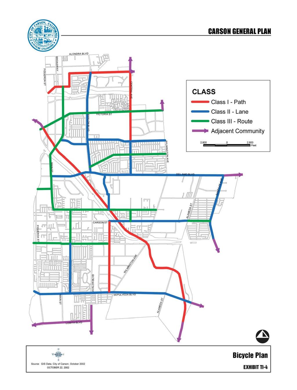
11 3.3 BICYCLE ROUTES DEFINITIONS The following bicycle route definitions were identified in the 1981 Circulation Element, Master Plan of Bikeways, and are still applicable. These include, in parentheses, the Caltrans standard designation, recognized Statewide. Bicycle Path (Class I). This facility is a special path for exclusive use of bicycles that is completely separated from the motor vehicle traffic by space or a physical barrier. Bicycle paths are often provided in recreational areas such as parks and on beaches. Bicycle Lane (Class II). A bicycle facility where a portion of the paved roadway area is marked as a lane for use by bicycles only. It is identified by BIKE LANE signing, pavement marking and lane line markings. Usually, special ordinances are necessary to legally define the exclusive use of bicycle traffic and to exclude mopeds and infringement by motor vehicles. Bicycle Route (Class III). A bicycle facility designated within a public right-of-way. The purpose of the bike route is primarily that of transportation, allowing the bicyclist to travel from one point in the City to another. A shared bicycle route is a street identified as a bicycle facility by BIKE ROUTE signing only. No special markings on the pavement are provided. BICYCLE PLAN The Bicycle Plan, shown on Exhibit TI-4, Bicycle Plan, includes the facilities listed in the 1981 Plan. Several segments have been added to and a few deleted from the 1981 Plan. The following roadway and other segments are designated Bike Path (Class I) facilities: Bonita Street between Sepulveda Boulevard and Carson Street (existing in Calas Park); Central Avenue between University Drive and 169th Street (existing University to Radbard Street); 169th Street between Billings Drive and Central Avenue; Walnut Street between Figueroa Street and Main Street; and Dominguez Channel The following roadway segments are designated Bike Lane (Class II) facilities: Avalon Boulevard between Del Amo Boulevard and 169th Street; Central Avenue between Del Amo Boulevard and University Drive (existing); Santa Fe between Del Amo Boulevard and I-405; Del Amo Boulevard between Figueroa Street and Santa Fe Avenue (existing between Wilmington and Avalon); Chapter 4 TI-10 Carson General Plan
12
13 Carson Street between Bonita Street and Alameda Street; and Chico Street between 213 th Street and Del Amo Boulevard (existing); University Drive between Avalon Boulevard and Wilmington (existing); Sepulveda Boulevard between Figueroa Street and the east City boundary; and 192 nd Street between Avalon Boulevard and Main Street. The following roadway segments are designated Bike Route (Class III) facilities: Main Street between 213 th Street and Walnut Street; Dolores Street between Sepulveda Boulevard and 213th Street (existing between Sepulveda Boulevard and Carson Street); Victoria Street between Figueroa Street and Wilmington Avenue; Turmont Street between Avalon Boulevard and Wilmington Avenue (existing); 213th Street between Main Street and Wilmington Avenue; Carson Street between Alameda Street and Santa Fe Avenue; 223rd Street between Figueroa Street and Bonita Street; Torrance Boulevard between Main Street and the west City boundary; and Vera Street between Carson Boulevard and 213 th Street. 3.4 TRANSIT FACILITIES Public transportation in the City of Carson is provided primarily by the Carson Circuit, Torrance Transit, and the Los Angeles County Metropolitan Transportation Authority (MTA) bus lines. There is also limited service from Long Beach Transit and Gardena Municipal Bus Lines. Following are brief descriptions of the major lines and routes in the project area, which are illustrated on Exhibit TI-5, Bus Routes. CARSON CIRCUIT TRANSIT SYSTEM Route A (Cal State Dominguez Hills) serves the northern Carson area in the vicinity of Cal State Dominguez Hills. Route A operates around Dominguez Hills Village and on Victoria Street between Avalon Boulevard and Central Avenue, Avalon Boulevard between Victoria Street and Del Amo Boulevard, Del Amo Boulevard between Avalon Boulevard and Wilmington Avenue, University Avenue between Avalon Boulevard and Wilmington Avenue, and Turmont Street between Leapwood Avenue and Wilmington Avenue. Route B (Keystone) serves the southwestern Carson area in the vicinity of Carson High School. Primary routes served by Route B include Main Street between Carson Street and 234 th Street, Moneta Street between Carson Street and 228 th Street, and Carson Street between Moneta Avenue and Avalon Boulevard. Chapter 4 TI-12 Carson General Plan
14
15 Route C (Scottsdale) primarily serves the Avalon Boulevard corridor between Del Amo Boulevard to the north and Sepulveda Boulevard to the south. Route D (Metro Blue Line 1) and Route G (Metro Blue Line 2) serve the central Carson area from Avalon Boulevard to the eastern City border. Route D travels in a clockwise pattern while Route G travels in a counterclockwise route. Both lines operate on Del Amo Boulevard between Avalon Boulevard and Santa Fe Avenue, in a circuitous pattern from Del Amo Boulevard to the Avalon Boulevard/Carson Street intersection, and Avalon Boulevard from Del Amo Boulevard to Carson Street. Route E (Turmont) serves the area just south, east and west of Cal State Dominguez Hills. Primary routes served by Route E include Avalon Boulevard between Victoria Street and Del Amo Boulevard, University Drive between Avalon Boulevard and Wilmington Avenue, and Turmont Street between Avalon Boulevard and Wilmington Avenue. Route F (Business Center South) serves the south central Carson area. Primary routes served by Route F include Bonita Street between 213 th Street and Watson Center Road, 213 th Street between Avalon Boulevard and Martin Street, and Wilmington Avenue between Watson Center Road and 233 rd Street. Route H (Hemingway Park) serves the north central Carson area. Primary routes served by Route H include Avalon Boulevard between Alondra Boulevard and Del Amo Boulevard and Alondra Boulevard between Avalon Boulevard and the northeastern City border. All Carson Circuit routes converge on the South Bay Pavilion so transfers are easy. Senior and disabled citizens ride free. TORRANCE TRANSIT BUS LINES Route 3 operates between downtown Long Beach and the Redondo Beach Pier. In the Carson area, primary routes served by Route 3 include Carson Street between Vermont Avenue and Avalon Boulevard, Avalon Boulevard between Carson Street and 223 rd Street, 223 rd Street between Avalon Boulevard and Dolores Street, Dolores Street between 223 rd Street and Sepulveda Boulevard, and Sepulveda Boulevard between Dolores Street and Wilmington Boulevard. Route 6 operates between the Metro Blue Line Artesia Station and the Del Amo Center Transit Terminal Park and Ride. In the Carson area, primary routes served by Route 6 include Victoria Street between Vermont Avenue and Central Avenue, Central Avenue between Victoria Street and Walnut Street, and Walnut Street from Central Avenue east to the Metro Blue Line Artesia Station. Senior and disabled citizens fares are discounted. Chapter 4 TI-14 Carson General Plan
16 MTA BUS LINES MTA Line 53 operates between Cal State Dominguez Hills and Downtown Los Angeles. In the Carson area, the primary route served by Line 53 is Central Avenue near Cal State Dominguez Hills. MTA Line 127 operates between Cal State Dominguez Hills, Compton, Paramount, Bellflower and Downey. In the Carson area, the primary route served by Line 127 is Avalon Boulevard between Cal State Dominguez Hills and Alondra Boulevard, and Alondra Boulevard between Avalon Boulevard and Wilmington Avenue. MTA Line 130 operates between Redondo Beach and the Fullerton park and ride lot located on Orangethorpe Avenue. In the Carson area, Line 130 traverses Victoria Street between Vermont Avenue to the west and Central Avenue to the east. MTA Line 202 operates between Wilmington and the Rosa Parks/Imperial/Wilmington Station in Willowbrook. In the Carson area, the primary route served by Line 202 is Avalon Boulevard between Lomita Boulevard and Carson Street, Carson Street between Avalon Boulevard and Alameda Street, and Alameda Street between Carson Street and Del Amo Boulevard. MTA Line 205 operates between Willowbrook and San Pedro. In the Carson area, Line 205 runs along 192 nd Street between Main Street and Avalon Boulevard, Avalon Boulevard between 192 nd Street and Del Amo Boulevard, Del Amo Boulevard between Avalon Boulevard and Wilmington Avenue, and Wilmington Avenue between Del Amo Boulevard and the SR-91 Freeway. MTA Lines 446/447 operate between downtown Los Angeles and San Pedro. In the Carson area, Lines 446/447 travel along Avalon Boulevard between the northern and southern borders of the City. Senior and disabled citizens fares are discounted. MTA METRO RAIL LINES Metro Blue Line operates between Long Beach and Downtown Los Angeles. In the Carson area, the closest Blue Line stations are Artesia and Del Amo. The Artesia station is located at /2 Acacia Avenue in Compton. The Del Amo station is located at Santa Fe Avenue in Los Angeles. Metro Green Line operates between Redondo Beach and Norwalk. While the Green Line does not run through Carson, the Green Line does connect with the Blue Line at the Rosa Parks (Imperial/Wilmington) station located at Wilmington Avenue in Los Angeles. Carson General Plan TI-15 Chapter 4
17 LONG BEACH TRANSIT Routes 191, 192, 193, and 194 all serve the far east side of the City of Carson, connecting the Del Amo Blue Line Station via Santa Fe Avenue to the Long Beach Civic Center. Senior and disabled citizens fares are discounted. GARDENA MUNICIPAL BUS LINES Line 3 operates between Compton and the South Bay Center in Torrance. In the Carson area, the primary routes served by Line 3 include Gardena Boulevard between Vermont Avenue and Avalon Boulevard, Avalon Boulevard between Alondra Boulevard and Gardena Boulevard, and Alondra Boulevard between Avalon Boulevard and Wilmington Avenue. Senior and disabled citizens fares are discounted. 3.5 SPECIALIZED SHUTTLE SERVICES CARSON NORTH/SOUTH SHUTTLE The City of Carson North/South Shuttle runs in one direction every forty minutes from Super K-Mart on Figueroa Avenue and Torrance Boulevard, north on Main Street to Victoria Street, back south on Main Street to Sepulveda Boulevard, and loops back north on Figueroa Street to Super K-Mart. It connects to the Carson Circuit, Torrance Transit and MTA bus lines. Senior and disabled citizens ride free and the regular fare is $.50. DIAL-A-RIDE SERVICE Economical taxi service is available to Carson seniors and/or disabled citizens twenty-four hours a day, seven days a week. Accessible mini-vans are available for wheelchair users. Service is provided anywhere within the City limits and to specific medical and social service appointments at satellite locations outside the City in Torrance, San Pedro, Gardena, Harbor City, Long Beach, Wilmington and Lomita. ACCESS SERVICES Access Services is another dial-a-ride specialized transportation service for disabled citizens throughout Los Angeles County. It is not administered by the City of Carson. It has a fleet of specially equipped vans and taxis offering curb-to-curb services. Chapter 4 TI-16 Carson General Plan
18 3.6 TRUCK ROUTES CURRENT CITY TRUCK ROUTES The City has many trucks on its streets due to the types of industrial and commercial uses in the City. There are no specific counts of trucks as opposed to other types of vehicles on City streets but it is estimated that trucks make up 10-25% of the vehicles over 24 hours. The volume of trucks, the impacts of truck traffic on land uses, and the conflict between trucks and other vehicles are major issues for the City. The City of Carson has designated truck routes and truck parking zones where vehicles in excess of three tons may travel and park. These routes and parking zones are shown in Exhibit TI-6, Truck Routes. The purpose of regulating truck routes and truck parking zones is to provide access for large trucks on streets designed to accommodate them and to protect residential streets from unwanted truck traffic. 3.7 EXISTING TRAFFIC OPERATIONS ANALYSIS The ground traffic counts provide the roadway segment volumes used in the existing conditions analysis of the volume-to-capacity ratio for the roadway level of service. The assumed capacities on roadway links were based on the standards used by the County of Los Angeles and modified for special conditions in Carson. The capacities reflect the maximum number of vehicles per hour that can reasonably be carried on the roadway under prevailing traffic conditions. The capacities reflect the presence of intersections that reduce link capacities by assigning traffic signal time to each intersection street. The assumed roadway capacities of each type of facility are shown in Table TI-2, Roadway Capacities. Table TI-2 Roadway Capacities Facility Type Hourly Capacity (veh. /lane/hour) Two way major arterial 750 Two way secondary arterial 750 Collector and local streets 750 Level of Service (LOS) terms are used to qualitatively describe prevailing conditions and their effect on traffic. Broadly interpreted, the LOS concept denotes any one of a number of differing combinations of operating conditions that may take place as a roadway is accommodating various traffic volumes. The LOS is related to the volume-to-capacity ratio (V/C). To determine the V/C ratio, the average daily traffic volume on a particular roadway link is divided by the link capacity. There are Carson General Plan TI-17 Chapter 4
19
20 six defined Levels of Service, A through F, which describe conditions ranging from ideal to worst as defined in Table TI-3, Level of Service Descriptions. Table TI-3 Level of Service Descriptions Level of Service A B C D E F Description Excellent operation. All approaches to the intersection appear quite open, turning movements are easily made, and nearly all drivers find freedom of operation. Very good operation. Many drivers begin to feel somewhat restricted within platoons of vehicles. This represents stable flow. An approach to an intersection may occasionally be fully utilized and traffic queues start to form. Good operation. Occasionally drivers may have to wait more than 60 seconds, and backups may develop behind turning vehicles. Most drivers feel somewhat restricted. Fair operation. Cars are sometimes required to wait more than 60 seconds during short peaks. There are no long-standing traffic queues. This level is typically associated with design practice for peak periods. Poor operation. Some long-standing vehicular queues develop on critical approaches to intersections. Delays may be up to several minutes. Forced flow. Represents jammed conditions. Backups from locations downstream or on the cross street may restrict or prevent movement of vehicles out of the intersection approach lanes; therefore, volumes carried are not predictable. Potential for stop and go type traffic flow. Volume to Capacity Ratio Over 1.01 Source: Highway Capacity Manual, Special Report 209, Transportation Research Board, Washington, D.C., 1985 and Interim Materials on Highway Capacity, NCHRP Circular 212, The analysis of the existing AM and PM peak volumes on arterial operating conditions was conducted by comparing the peak traffic volumes and estimated capacity for each roadway. The results of this analysis are summarized in Table TI- 4, Existing AM Peak Hour Level of Service, and TI-5, Existing PM Peak Hour Level of Service and presented graphically on Exhibit TI-7, Existing Level of Service. Tables TI-4 and TI-5 reveal that the majority of roadways in the City of Carson operate at LOS D or better. The following three roadway segments currently operate at LOS E or F: Wilmington Avenue from 223rd Street to I-405 Freeway (AM/PM Peak); Wilmington Avenue from Carson Street to 213th Street (AM Peak); 223rd Street from Wilmington Avenue to Alameda Street (PM Peak). Carson General Plan TI-19 Chapter 4
21 Street From Segment Table TI-4 Existing AM Peak Hour Level of Service To Class Capacity per Lane Number of Lanes Existing Volume V/C Ratio Level of Service 213 th St Main St Avalon Blvd Collector C B 213 th St Avalon St Chico St Collector A A 213 th St Chico St Wilmington Ave Collector A A 220 th St Main St Avalon Blvd Collector A A 223 rd St Figueroa St Main St Major A A 223 rd St Main St Avalon Blvd Major A A 223 rd St Avalon St Wilmington Ave Major A A 223 rd St Wilmington Ave Alameda St Major A A 228 th St Main St Avalon Blvd Collector A A Alameda St Lomita Blvd Sepulveda Blvd Major A A Alameda St Sepulveda Blvd 223rd St Major A A Alameda St I-405 Fwy Carson St Major A A Alameda St Carson St Dominguez St Major A A Albertoni St Figueroa St Main St Secondary A A Albertoni St Main St Avalon Blvd Secondary A A Albertoni St Avalon St SR-91 Fwy Secondary A A Alondra Blvd Figueroa St Main St Major A A Alondra Blvd Main St Avalon Blvd Major A A Avalon Blvd Lomita Blvd Sepulveda Blvd Major A A Avalon Blvd Sepulveda Blvd 223rd St Major A A Avalon Blvd 223 rd St Carson St Major A A Avalon Blvd Carson St 213th St Major A A Avalon Blvd 213 th St I-405 Fwy Major A A Avalon Blvd Dominguez St Del Amo Blvd Major A A Avalon Blvd Del Amo Blvd University Dr Major A A Avalon Blvd University Dr Victoria St Major A A Avalon Blvd Victoria St Albertoni St Major A A Avalon Blvd SR-91 Fwy Gardena Blvd Major A A Avalon Blvd Gardena Blvd Alondra Blvd Major A A Broadway Main St Victoria St Major A A Broadway Victoria St Albertoni St Major A A Broadway SR-91 Fwy Gardena Blvd Major A A Broadway Gardena Blvd Alondra Blvd Major A A Carson St Figueroa St Main St Major A A Carson St Main St Avalon Blvd Major A B Carson St Avalon St I-405 Fwy Major C C Carson St I-405 Fwy Wilmington Ave Major A A Carson St Wilmington Ave Alameda St Major A B Carson St Alameda St Santa Fe Ave Major A A Chapter 4 TI-20 Carson General Plan
22 Street From Segment Table TI-4 [continued] Existing AM Peak Hour Level of Service To Class Capacity per Lane Number of Lanes Existing Volume V/C Ratio Level of Service Central Ave Del Amo Blvd Turmont St Major A A Central Ave Turmont St University Dr Major A A Central Ave University Dr Victoria St Major A A Del Amo Blvd Figueroa St Main St Major A A Del Amo Blvd Main St Avalon Blvd Major A A Del Amo Blvd Avalon St Central Ave Major A A Del Amo Blvd Central Ave Wilmington Ave Major A A Dolores St Sepulveda Blvd 228th St Collector A A Figueroa St Lomita Blvd Sepulveda Blvd Major A A Figueroa St Sepulveda Blvd 223rd St Major A A Figueroa St 223rd St Carson St Major A A Figueroa St Carson St Torrance Blvd Major A A Figueroa St Torrance Blvd Del Amo Blvd Major D A Figueroa St Del Amo Blvd I-405 Fwy Major A A Figueroa St I-405 Fwy Victoria St Major A A Figueroa St Victoria St SR-91 Fwy Major A A Figueroa St SR-91 Fwy Gardena Blvd Major A A Figueroa St Gardena Blvd Alondra Blvd Major A A Gardena Blvd Figueroa St Main St Secondary A A Gardena Blvd Main St Avalon Blvd Secondary A A Lomita Blvd Figueroa St Main St Major A B Lomita Blvd Main St Avalon Blvd Major A A Lomita Blvd Wilmington Ave Alameda St Major A A Main St Lomita Blvd Sepulveda Blvd Major B A Main St Sepulveda Blvd 223rd St Major A A Main St 223rd St Carson St Major A A Main St Carson St 213th St Major A A Main St 213th St Torrance Blvd Major A A Main St Torrance Blvd Del Amo Blvd Major A A Main St Del Amo Blvd I-405 Fwy Major A A Main St I-405 Fwy Broadway Major A A Main St Broadway Victoria St Major A A Main St Victoria St Albertoni St Major A A Main St SR-91 Fwy Gardena Blvd Major A A Main St Gardena Blvd Alondra Blvd Major A A Moneta Ave 228th St 223rd St Collector A A Santa Fe Ave Carson St Dominguez St Secondary A B Santa Fe Ave Dominguez St Del Amo Blvd Secondary A B Sepulveda Blvd Figueroa St Main St Major A A Sepulveda Blvd Main St Avalon Blvd Major B A Carson General Plan TI-21 Chapter 4
23 Street From Segment Table TI-4 [continued] Existing AM Peak Hour Level of Service To Class Capacity per Lane Number of Lanes Existing Volume V/C Ratio Level of Service Sepulveda Blvd Avalon St Wilmington Ave Major A A Sepulveda Blvd Wilmington Ave Alameda St Major A A Sepulveda Blvd Alameda St Intermodal Major A A Torrance Blvd Figueroa St Main St Secondary A A University Dr Avalon St Central Ave Secondary A A University Dr Central Ave Wilmington Ave Secondary A A Victoria St Figueroa St Main St Major A A Victoria St Main St Avalon Blvd Major A A Victoria St Avalon St Tamcliff Ave Major A A Victoria St Tamcliff Ave Central Ave Major A A Victoria St Central Ave Wilmington Ave Major A A Wilmington Ave Lomita Blvd Sepulveda Blvd Major A A Wilmington Ave Sepulveda Blvd 223rd St Major A A Wilmington Ave 223rd St I-405 Fwy Major C F Wilmington Ave I-405 Fwy Carson St Major A A Wilmington Ave Carson St 213th St Major E A Wilmington Ave 213th St Del Amo Blvd Major B A Wilmington Ave Del Amo Blvd University Dr Major A B Wilmington Ave University Dr Victoria St Major A A Chapter 4 TI-22 Carson General Plan
24 Street From Segment Table TI-5 Existing PM Peak Hour Level of Service To Class Capacity per Lane Number of Lanes Existing Volume V/C Ratio Level of Service 213th St Main St Avalon Blvd Collector D D 213th St Avalon St Chico St Collector A A 213th St Chico St Wilmington Ave Collector A A 220th St Main St Avalon Blvd Collector B A 223rd St Figueroa St Main St Major B A 223rd St Main St Avalon Blvd Major B A 223rd St Avalon St Wilmington Ave Major A A 223rd St Wilmington Ave Alameda St Major F A 228th St Main St Avalon Blvd Collector A A Alameda St Lomita Blvd Sepulveda Blvd Major A A Alameda St Sepulveda Blvd 223rd St Major A A Alameda St I-405 Fwy Carson St Major A A Alameda St Carson St Dominguez St Major A A Albertoni St Figueroa St Main St Secondary A A Albertoni St Main St Avalon Blvd Secondary D A Albertoni St Avalon St SR-91 Fwy Secondary C A Alondra Blvd Figueroa St Main St Major A A Alondra Blvd Main St Avalon Blvd Major A A Avalon Blvd Lomita Blvd Sepulveda Blvd Major A A Avalon Blvd Sepulveda Blvd 223rd St Major A A Avalon Blvd 223rd St Carson St Major B B Avalon Blvd Carson St 213th St Major A A Avalon Blvd 213th St I-405 Fwy Major A B Avalon Blvd Dominguez St Del Amo Blvd Major A A Avalon Blvd Del Amo Blvd University Dr Major A A Avalon Blvd University Dr Victoria St Major A A Avalon Blvd Victoria St Albertoni St Major A A Avalon Blvd SR-91 Fwy Gardena Blvd Major A A Avalon Blvd Gardena Blvd Alondra Blvd Major A A Broadway Main St Victoria St Major A A Broadway Victoria St Albertoni St Major A A Broadway SR-91 Fwy Gardena Blvd Major A A Broadway Gardena Blvd Alondra Blvd Major A A Carson St Figueroa St Main St Major D B Carson St Main St Avalon Blvd Major D B Carson St Avalon St I-405 Fwy Major D B Carson St I-405 Fwy Wilmington Ave Major A A Carson St Wilmington Ave Alameda St Major A A Carson St Alameda St Santa Fe Ave Major A A Central Ave Del Amo Blvd Turmont St Major A A Central Ave Turmont St University Dr Major A A Central Ave University Dr Victoria St Major A A Carson General Plan TI-23 Chapter 4
25 Street From Segment Table TI-5 [continued] Existing PM Peak Hour Level of Service To Class Capacity per Lane Number of Lanes Existing Volume V/C Ratio Level of Service Del Amo Blvd Figueroa St Main St Major A A Del Amo Blvd Main St Avalon Blvd Major A A Del Amo Blvd Avalon St Central Ave Major A A Del Amo Blvd Central Ave Wilmington Ave Major A A Dolores St Sepulveda Blvd 228th St Collector A A Figueroa St Lomita Blvd Sepulveda Blvd Major A A Figueroa St Sepulveda Blvd 223rd St Major A A Figueroa St 223rd St Carson St Major A A Figueroa St Carson St Torrance Blvd Major A A Figueroa St Torrance Blvd Del Amo Blvd Major C A Figueroa St Del Amo Blvd I-405 Fwy Major A C Figueroa St I-405 Fwy Victoria St Major A A Figueroa St Victoria St SR-91 Fwy Major A A Figueroa St SR-91 Fwy Gardena Blvd Major A A Figueroa St Gardena Blvd Alondra Blvd Major A A Gardena Blvd Figueroa St Main St Secondary A A Gardena Blvd Main St Avalon Blvd Secondary A A Lomita Blvd Figueroa St Main St Major D A Lomita Blvd Main St Avalon Blvd Major A A Lomita Blvd Wilmington Ave Alameda St Major A A Main St Lomita Blvd Sepulveda Blvd Major A A Main St Sepulveda Blvd 223rd St Major A A Main St 223rd St Carson St Major A B Main St Carson St 213th St Major A B Main St 213th St Torrance Blvd Major A B Main St Torrance Blvd Del Amo Blvd Major A A Main St Del Amo Blvd I-405 Fwy Major A A Main St I-405 Fwy Broadway Major A B Main St Broadway Victoria St Major A A Main St Victoria St Albertoni St Major A A Main St SR-91 Fwy Gardena Blvd Major A A Main St Gardena Blvd Alondra Blvd Major A A Moneta Ave 228th St 223rd St Collector A A Santa Fe Ave Carson St Dominguez St Secondary C C Santa Fe Ave Dominguez St Del Amo Blvd Secondary D B Sepulveda Blvd Figueroa St Main St Major A A Sepulveda Blvd Main St Avalon Blvd Major A A Sepulveda Blvd Avalon St Wilmington Ave Major A A Sepulveda Blvd Wilmington Ave Alameda St Major A A Sepulveda Blvd Alameda St Intermodal Major A A Chapter 4 TI-24 Carson General Plan
26 Street From Segment Table TI-5 [continued] Existing PM Peak Hour Level of Service To Class Capacity per Lane Number of Lanes Existing Volume V/C Ratio Level of Service Torrance Blvd Figueroa St Main St Secondary A A University Dr Avalon St Central Ave Secondary A A University Dr Central Ave Wilmington Ave Secondary A A Victoria St Figueroa St Main St Major C A Victoria St Main St Avalon Blvd Major B A Victoria St Avalon St Tamcliff Ave Major A A Victoria St Tamcliff Ave Central Ave Major A A Victoria St Central Ave Wilmington Ave Major A B Wilmington Ave Lomita Blvd Sepulveda Blvd Major A A Wilmington Ave Sepulveda Blvd 223rd St Major A B Wilmington Ave 223rd St I-405 Fwy Major C F Wilmington Ave I-405 Fwy Carson St Major A B Wilmington Ave Carson St 213th St Major B D Wilmington Ave 213th St Del Amo Blvd Major A B Wilmington Ave Del Amo Blvd University Dr Major B B Wilmington Ave University Dr Victoria St Major A A Carson General Plan TI-25 Chapter 4
27
28 3.8 INFRASTRUCTURE/UTILITIES SEWER The Los Angeles County Public Works Department (LACPWD) maintains the local sewer lines that run in the street to the trunk sewer lines. The homeowner is responsible for maintenance of the lateral connection lines from the structure to the street. Most local sewer lines are eight inches in diameter. No new upgrades are currently planned. The LACPWD also maintains two small lift stations that are located within the Carson boundaries: Scottsdale Pump Station Avalon Boulevard Capacity: 100 gallons per minute Belshaw Pump Station Belshaw Avenue Capacity: 1,125 gallons per minute The Los Angeles County Sanitation District (Sanitation District) maintains the trunk sewer lines within the City of Carson. There are approximately one dozen trunk sewer lines, ranging in size from 50 inches to 8 feet in diameter, which are generally located as follows: Del Amo Boulevard running east to west Main Street running north to south Wilmington Avenue 3 lines running north to south, 2 lines running east to west along railroad tracks Alameda Street 2 lines running north to south Broadway 2 lines running north to south The Joint Water Pollution Control Plant, located at South Figueroa Street in Carson, is part of the Joint Outfall System that provides sewage treatment and disposal for residential, commercial and industrial users within the 17 sanitation districts in Los Angeles County that are participants in the Joint Outfall Agreement. The Joint Water Pollution Control Plant (JWPCP) is one of the largest wastewater treatment plants in the world. It serves a population of about 3.5 million people and many industries in southern and eastern Los Angeles County. It provides advanced primary and partial secondary treatment for 350 million gallons of wastewater per day. WATER Water service in the City of Carson is provided by the California Water Service Company (formerly Dominguez Water Corporation) and the Southern California Water Company (SCWC). Carson General Plan TI-27 Chapter 4
29 The California Water Service Company (California Water) is an investor-owned public water utility. Its rates and operations are regulated by the California Public Utilities Commission. Its service area, located in the South Bay, covers a 35 square mile area, including most of the City of Carson. California Water supply has two principal sources: local groundwater and purchased imported water. Imported water is purchased from the Metropolitan Water District of Southern California (MWD) through a member agency, the West Basin Municipal Water District (MWD). California Water has eight direct MWD service connections and one indirect MWD service connection. California Water also participates in the MWD-sponsored In-Lieu Water Programs, whereby water suppliers purchase imported water from MWD at a reduced rate instead of pumping groundwater. The non-pumped groundwater then stays in the basins for use in the future when imported water may not be as plentiful. Table TI-6, Sources of California Water Company Production, illustrates the amount of groundwater, imported water and desalinated water production for 1990 through The company treats all of its water supply to meet drinking water standards, regardless of source. Table TI-6 Sources of California Water Company Production Average Groundwater (acre feet) % of Total Imported Water (acre feet) % of Total Desalinated Water (acre feet) % of Total Total Water Production (acre feet) 7,873 20% 30,988 80% 8,594 27% 23,603 73% 6,612 20% 26,963 80% 1 0% 32,647 97% 905 3% 4,006 12% 29,150 84% 1,563 4% 10,654 30% 24,324 67% 1,181 3% 6,290 18% 27,946 80% 38,861 32,196 33,575 33,553 34,719 36,159 34, % Source: Sources of Water Production (Acre Feet). The total number of California Water customers is projected to grow approximately 6.2 percent from 1995 to Future shifts in water demand most likely would result from either the expansion/downsizing of major industrial customers, new industrial customer growth and the introduction of recycled water. To meet water demands for the next decade, the company will rely on a mix of ground, imported, desalinated and recycled water sources. California Water projections indicate that, under normal precipitation conditions, it will have sufficient water supplies to meet annual customer water demand through This is based on the continuation of conservation programs, on desalinated and recycled water becoming available, and on planned efforts to emphasize groundwater supplies and to reduce reliance on imported water sources. Chapter 4 TI-28 Carson General Plan
30 The SCWC, Southwest District, serves a small portion of north Carson. It is an investor-owned private utility company that supplies water service to approximately 2,030 customers within the City of Carson. Carson lies within the Lawndale/ Gardena Zone, which has an average daily demand of 13,900 gpm, a maximum daily demand of 20,850 gpm, and a peak hour demand of 35,445 gpm. The Southwest District of Southern California Water purchases approximately 80 percent of its water demand from MWD connections within the service area, and approximately 20 percent of its water demand is supplied through company-owned deep wells. Additional information regarding water quality and conservation can be found in: Chapter 8, Open Space and Conservation Element of this General Plan. Information regarding drainage facilities can be found in Chapter 6, Safety Element, of this General Plan. ELECTRIC Electric service is provided to the Carson area by Southern California Edison (SCE), Compton Service Center. There are three major substations within the Carson boundaries: 1) Carson Substation at Alameda Street and Johns Manville Street, 2) Nola Substation at South Broadway and Victoria Street, and 3) Neptune Station at 213 th Street and Grace Avenue. There are approximately one dozen transmission facilities (66kV) that extend along Wilmington Avenue and Alameda Street that feed the SCE service area or distribute directly to select high voltage customers. There are also numerous high voltage easements, ranging from 120 kv to 500 kv, that traverse the City of Carson. Electrical consumption factors are not available specifically for the City of Carson; however, annual estimated use factors are offered by SCE in Table TI-7, Electrical Consumption for Various Land Uses. Southern California Edison is continually analyzing the capacity of its systems and projecting and planning for new load growth based on commercial, industrial and residential customer demand. NATURAL GAS Natural gas is supplied to the City by Southern California Gas Company (The Gas Company), Pacific Region. As a public utility, The Gas Company is under the jurisdiction of Federal and State regulatory agencies. A medium and high pressure distribution pipeline system and a high pressure transmission pipeline system transect the Carson boundaries. There are no current deficiencies in the natural gas supply systems that serve Carson. The Gas Company continually assesses and upgrades its systems to meet current and future needs, and thus can accommodate any future expansion in residential, commercial or industrial uses. The Gas Company has also developed several programs to provide assistance in selecting energy efficient appliances and systems. Carson General Plan TI-29 Chapter 4
31 Table TI-7 Electrical Consumption for Various Land Uses Land Use Type Unit Type SCE Factor Residential Kilowatt-hour/Unit/Year 6,081.0 Food Store Kilowatt-hour/Square Feet/Year 51.4 Restaurant Kilowatt-hour/Square Feet/Year 47.3 Hospital Kilowatt-hour/Square Feet/Year 17.9 Retail Kilowatt-hour/Square Feet/Year 11.8 College/University Kilowatt-hour/Square Feet/Year 11.6 High School Kilowatt-hour/Square Feet/Year 8.8 Elementary School Kilowatt-hour/Square Feet/Year 6.3 Office Kilowatt-hour/Square Feet/Year 8.8 Hotel/Motel Kilowatt-hour/Square Feet/Year 6.8 Warehouse Kilowatt-hour/Square Feet/Year 3.4 Miscellaneous Kilowatt-hour/Square Feet/Year 8.8 Source: South Coast Air Quality Management District, CEQA Air Quality Handbook, Appendix 9, September SOLID WASTE DISPOSAL Waste Management currently provides residential, commercial and industrial waste collection service for the City of Carson. Waste Management collects approximately 70,000 tons from residential customers and 153,500 tons from commercial and industrial customers per year. The disposal service uses traditional methods of solid waste collection using standard trash trucks and crews. The service also includes the pickup of sorted recyclable materials, which are transported directly to a company that separates and sells them. The solid waste collected by Waste Management is transported to the company s transfer station at 321 W. Francisco Street in Carson, where it is sorted. The 10-acre facility has a permitted capacity of 5,300 tons per day. After the materials are sorted, tires, green waste, steel, and wood are sent to special facilities for disposal or recycling. The remaining waste materials are loaded onto trailers and taken to the El Sobrante Landfill in Riverside County, a distance of 75 miles from Carson. The El Sobrante Landfill currently has a capacity of 4000 tons a day but is expected to increase to 7500 tons per day by the year 2004, due to the construction of service roads. Its current life expectancy is 100 years. Waste Management also uses Lancaster Landfill and Simi Valley Landfill as alternates. Additional information regarding solid waste can be found in Chapter 8, Open Space and Conservation of this General Plan. Chapter 4 TI-30 Carson General Plan
32 CABLE The City has multiple cable providers. One upgraded its system within the last several years to the latest fiber optics. The increased capacity now allows the company to offer 65 basic channels and a choice of 12 premium channels. Internet connections are available through one provider. TELEPHONE There are also multiple telephone service providers. The telephone service facilities consist of both fiber and copper facilities. A light span technique that enhances service is also used in the Carson area. A sonet ring provides improved service to the general South Bay area. There are both aerial and underground lines within the City of Carson. Undergrounding of new facilities is considered on a case-by-case basis. There is need for upgraded facilities to provide new services to existing customers and to expand services to new customer facilities, especially related to computers. The City has approved many telecommunications antennae. 4.0 FUTURE CIRCULATION SYSTEM CONDITIONS WITH GENERAL PLAN BUILDOUT 4.1 AMBIENT TRAFFIC GROWTH Ambient traffic growth is the traffic growth, not including freeways, that will occur in the City due to general employment growth, housing growth and growth in regional through trips in southern California. Even if there were no change in housing or employment in the City of Carson, there would be some background (ambient) traffic growth in the region. Per discussions with City staff, an ambient growth rate of 0.25 percent per year for the next 20 years is used, which represents a total of 5 percent ambient growth over 20 years. 4.2 SHORT-TERM TRAFFIC GROWTH Short-term traffic growth is growth due to recently approved development projects in the City. City staff provided the information on projects approved but not completed as of December Table TI-8, Short-Term Growth Trip Generation in Carson, summarizes the trip generation estimates for these projects. Individual approved project trip generation estimates are presented in Appendix B. 4.3 FORECAST FUTURE TRIP GENERATION The first step in analyzing future traffic condition is to predict future trip generation. The Institute of Transportation Engineers (ITE) has published trip generation rates for numerous land uses in Trip Generation 6th Edition, which has been adopted as a standard by nearly all agencies and cities in southern California. The Los Angeles County Congestion Management Program (CMP) guidelines also recommend the use of ITE trip generation data, but allow other rates to be used in Carson General Plan TI-31 Chapter 4
33 special cases if sufficient empirical data is provided and documented. Trips have therefore been calculated based on ITE s trip rates for the General Plan buildout. Table TI-8 Short-Term Growth Trip Generation in Carson Land Use Type Size Estimated New Trips (Units/ Square Feet) AM Peak Hour PM Peak Hour Development Status Report Project Trips Low Density Residential High Density Residential Light Industrial 2,294,147 1,173 1,207 Heavy Industrial 197, Commercial 256, Office/Business Park 1,480,000 1,854 2,717 Other (Training Center, Church, Daycare, Tech.) 1,897,238 2,420 2,628 Trips for Development Status Report Projects 6,410 8,376 Future trip generation rates are described in Table TI-9, Forecast Future Trip Generation in Carson. As shown in Table TI-9, the greatest number of new trips would occur due to development in light industrial land uses, which accounts for approximately 61 percent of all new trips during the AM peak hour and 46 percent of all new trips during the PM peak hour, followed by development of residential, retail, and office. Pass-by trips were assumed to be 25 percent of all retail commercial trips (consistent with ITE standards). 4.4 FUTURE TRIP DISTRIBUTION The distribution of the future trips describes the paths taken by new trips to and from the buildout locations. The traffic model that was developed for this Element includes a series of trip destination points around the City of Carson where trips will enter and leave the City on their way to the cumulative project driveways. The amount of traffic using each access route is an important variable in the overall traffic analysis. To determine the likely trip origins and destinations, the regional traffic model developed by the Southern California Association of Governments (SCAG) was reviewed. The SCAG model includes trip patterns for Traffic Analysis Zones (TAZs) within Carson. Those patterns are based on origin/destination surveys that were developed by SCAG. The model was used to determine the share of traffic for each cumulative project using the key arterial facilities in the City. The data is then refined for the City of Carson, based on the location of the City and its accessibility to regional freeways and roadway systems. Exhibit TI-8, Project Trip Distribution Pattern, illustrates the assumed trip distribution patterns that were developed for this Element. These patterns were varied as appropriate based on the location of individual project areas, for example, project areas closer to I-405 were Chapter 4 TI-32 Carson General Plan
34
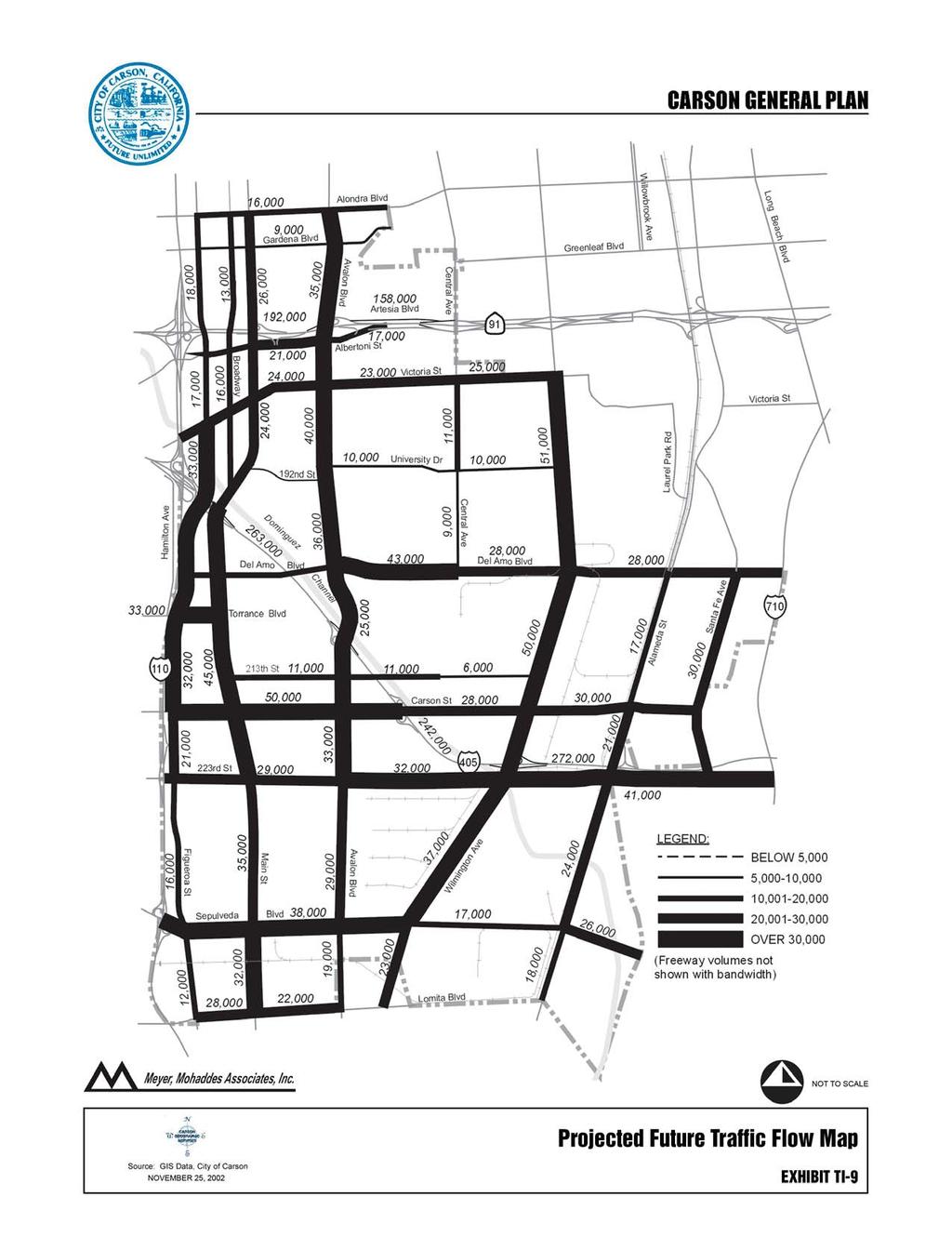
35 more heavily weighed to use the I-405 freeway, and similarly for those areas near the I-110 and SR-91, etc. Table TI-9 Forecast Future Trip Generation in Carson Land Use Type Size Estimated New Trips (Units/ Square Feet) AM Peak Hour PM Peak Hour Low Density Residential High Density Residential Light Industrial 10,023,200 8,955 9,628 Commercial 3,041,506 1,704 7,387 Office/Business Park 2,111,700 3,268 2,892 Other (Hotel) 300, Total Trips 14,565 20, TRAFFIC REDISTRIBUTION DUE TO DEL AMO OVER-CROSSING OF I-405 FREEWAY The Del Amo over-crossing of the I-405 freeway was completed in May This new link in the circulation system resulted in traffic redistribution on parallel and connecting roadways of existing traffic volumes. The new facility enabled motorists to make the freeway crossing on Del Amo Boulevard, if desired, rather than using Carson Street or Victoria Street. The new crossing resulted in shorter path trips for some motorists. The redistributed traffic was estimated using the regional model of the Southern California Association of Governments. The model was run with and without the new Del Amo over-crossing and the resulting differences in traffic loading was assessed. For both the AM and PM peak hours, adjustments to link volumes were applied to reflect the effects of the new over-crossing. As expected, the model results indicated that parallel route traffic volumes would decrease, while Del Amo Boulevard will increase in the vicinity of the new crossing. Additionally, some of the connecting routes to Del Amo Boulevard would experience an increase in traffic. The over-crossing was included in the traffic model for future project-added trips. The new crossing was assumed in the local area traffic model, and future project trips were assigned to the over-crossing as if it were in place today. Using this methodology, the impacts and benefits of the new over-crossing were fully accounted for in the traffic analysis. 4.6 FUTURE TRAFFIC VOLUMES Future traffic volumes with General Plan buildout were estimated by assigning project traffic to the City roadway network based on the trip distribution described above, and are shown in Exhibit TI-9, Projected Future Traffic Flow Map. The results were then evaluated for potential deficiencies (LOS E or F conditions with buildout Chapter 4 TI-34 Carson General Plan
36 of general plan. Table TI-10, Future AM Peak Hour Level of Service With General Plan Growth, and Table TI-11, Future PM Peak Hour Level of Service With General Plan Growth, presents the Future Conditions levels of service with general plan buildout. The bold locations indicate forecast deficiencies in the future. Exhibit TI- 10, Deficient Segments (AM Peak Hour), and Exhibit TI-11, Deficient Segments (PM Peak Hour), graphically depict the locations of the deficient roadway segments. The following 17 roadway segments would operate at LOS E or F: 223 rd Street from Wilmington Avenue to Alameda Street (PM) Avalon Boulevard from Dominguez Street to Del Amo Boulevard (PM) Carson Street from Figueroa Street to Main Street (PM) Carson Street from Main Street to Avalon Boulevard (PM) Carson Street from Avalon Boulevard to I-405 (PM) Central Avenue from University Drive to Victoria Street (AM/PM) Del Amo Boulevard from Avalon Boulevard to Central Avenue (PM) Main Street from Carson Street to 213 th Street (AM/PM) Main Street from 213 th Street to Torrance Boulevard (AM/PM) Main Street from Torrance Boulevard to Del Amo Boulevard (AM/PM) Sepulveda Boulevard from Figueroa Street to Main Street (PM) Torrance Boulevard from Figueroa Street to Main Street (AM/PM) Wilmington Avenue from 223 rd Street to I-405 (AM/PM) Wilmington Avenue from I-405 to Carson Street (AM/PM) Wilmington Avenue from Carson Street to 213 th Street (AM/PM) Wilmington Avenue from 213 th Street to Del Amo Boulevard (AM/PM) Wilmington Avenue from University Drive to Victoria Street (AM/PM) 5.0 TRANSPORTATION SYSTEM IMPROVEMENTS This report presents the summary of future operating conditions given the anticipated development in the City and in the area surrounding the City. It has been determined that several transportation system deficiencies would remain with the current Master Plan of Highways assumed to be built. This section discusses potential additional roadway system improvements to consider in order to maintain adequate service levels in the future. 5.1 PLAN OF STREETS AND HIGHWAYS The proposed Plan of Streets and Highways, shown as Exhibit TI-12, Plan of Streets and Highways, has few changes from the 1981 Plan. It is proposed that: Carson Street between the western City boundary and Avalon Boulevard be made a Modified Secondary Highway; A new roadway of Major Highway capacity be required through the 157 acre site at Avalon and I-405; Carson General Plan TI-35 Chapter 4
37
38 Street Table TI-10 Future AM Peak Hour Level of Service With General Plan Growth From Segment To Class Capacity per Lane Number of Lanes Future Volume V/C Ratio Level of Service 213th St Main St Avalon Blvd Collector D F 213th St Avalon St Chico St Collector C D 213th St Chico St Wilmington Ave Collector A A 220th St Main St Avalon Blvd Collector C B 223rd St Figueroa St Main St Major A B 223rd St Main St Avalon Blvd Major A B 223rd St Avalon St Wilmington Ave Major A B 223rd St Wilmington Ave Alameda St Major B D 228th St Main St Avalon Blvd Collector A A Alameda St Lomita Blvd Sepulveda Blvd Major A A Alameda St Sepulveda Blvd 223rd St Major A B Alameda St I-405 Fwy Carson St Major A A Alameda St Carson St Dominguez St Major A A Albertoni St Figueroa St Main St Secondary A A Albertoni St Main St Avalon Blvd Secondary A C Albertoni St Avalon St SR-91 Fwy Secondary A A Alondra Blvd Figueroa St Main St Major A A Alondra Blvd Main St Avalon Blvd Major A A Avalon Blvd Lomita Blvd Sepulveda Blvd Major A A Avalon Blvd Sepulveda Blvd 223rd St Major D A Avalon Blvd 223rd St Carson St Major D B Avalon Blvd Carson St 213th St Major A A Avalon Blvd 213th St I-405 Fwy Major A A Avalon Blvd Dominguez St Del Amo Blvd Major D A Avalon Blvd Del Amo Blvd University Dr Major B A Avalon Blvd University Dr Victoria St Major A A Avalon Blvd Victoria St Albertoni St Major A A Avalon Blvd SR-91 Fwy Gardena Blvd Major A A Avalon Blvd Gardena Blvd Alondra Blvd Major A A Broadway Main St Victoria St Major A A Broadway Victoria St Albertoni St Major A A Broadway SR-91 Fwy Gardena Blvd Major A A Broadway Gardena Blvd Alondra Blvd Major A A Carson St Figueroa St Main St Secondary F D Carson St Main St Avalon Blvd Secondary E F Carson St Avalon St I-405 Fwy Major F F Carson St I-405 Fwy Wilmington Ave Major C A Carson St Wilmington Ave Alameda St Major A F Carson St Alameda St Santa Fe Ave Major A E Central Ave Del Amo Blvd Turmont St Major A A Central Ave Turmont St University Dr Major A A Central Ave University Dr Victoria St Major F F Carson General Plan TI-37 Chapter 4
39 Street Table TI-10 [continued] Future AM Peak Hour Level of Service With General Plan Growth From Segment To Class Capacity per Lane Number of Lanes Future Volume V/C Ratio Level of Service Del Amo Blvd Figueroa St Main St Major D A Del Amo Blvd Main St Avalon Blvd Major E A Del Amo Blvd Avalon St Central Ave Major F F Del Amo Blvd Central Ave Wilmington Ave Major A D Dolores St Sepulveda Blvd 228th St Collector A A Figueroa St Lomita Blvd Sepulveda Blvd Major A A Figueroa St Sepulveda Blvd 223rd St Major A A Figueroa St 223rd St Carson St Major C A Figueroa St Carson St Torrance Blvd Major F A Figueroa St Torrance Blvd Del Amo Blvd Major F A Figueroa St Del Amo Blvd I-405 Fwy Major A C Figueroa St I-405 Fwy Victoria St Major C B Figueroa St Victoria St SR-91 Fwy Major A A Figueroa St SR-91 Fwy Gardena Blvd Major A A Figueroa St Gardena Blvd Alondra Blvd Major A A Gardena Blvd Figueroa St Main St Secondary A A Gardena Blvd Main St Avalon Blvd Secondary A A Lomita Blvd Figueroa St Main St Major B B Lomita Blvd Main St Avalon Blvd Major A A Lomita Blvd Wilmington Ave Alameda St Major A A Main St Lomita Blvd Sepulveda Blvd Major D C Main St Sepulveda Blvd 223rd St Major B A Main St 223rd St Carson St Major E B Main St Carson St 213th St Major F C Main St 213th St Torrance Blvd Major F B Main St Torrance Blvd Del Amo Blvd Major F D Main St Del Amo Blvd I-405 Fwy Major C C Main St I-405 Fwy Broadway Major B C Main St Broadway Victoria St Major A A Main St Victoria St Albertoni St Major A A Main St SR-91 Fwy Gardena Blvd Major B B Main St Gardena Blvd Alondra Blvd Major A B Moneta Ave 228th St 223rd St Collector A A Santa Fe Ave Carson St Dominguez St Secondary D D Santa Fe Ave Dominguez St Del Amo Blvd Secondary C E Sepulveda Blvd Figueroa St Main St Major E C Sepulveda Blvd Main St Avalon Blvd Major D B Sepulveda Blvd Avalon St Wilmington Ave Major D A Sepulveda Blvd Wilmington Ave Alameda St Major A A Sepulveda Blvd Alameda St Intermodal Major A A Chapter 4 TI-38 Carson General Plan
40 Street Table TI-10 [continued] Future AM Peak Hour Level of Service With General Plan Growth From Segment To Class Capacity per Lane Number of Lanes Future Volume V/C Ratio Level of Service Torrance Blvd Figueroa St Main St Secondary F C University Dr Avalon St Central Ave Secondary A A University Dr Central Ave Wilmington Ave Secondary A A Victoria St Figueroa St Main St Major B B Victoria St Main St Avalon Blvd Major A A Victoria St Avalon St Tamcliff Ave Major B A Victoria St Tamcliff Ave Central Ave Major A A Victoria St Central Ave Wilmington Ave Major C C Wilmington Ave Lomita Blvd Sepulveda Blvd Major C A Wilmington Ave Sepulveda Blvd 223rd St Major F B Wilmington Ave 223rd St I-405 Fwy Major F F Wilmington Ave I-405 Fwy Carson St Major F E Wilmington Ave Carson St 213th St Major F C Wilmington Ave 213th St Del Amo Blvd Major F E Wilmington Ave Del Amo Blvd University Dr Major F D Wilmington Ave University Dr Victoria St Major A F Carson General Plan TI-39 Chapter 4
41 Street Table TI-11 Future PM Peak Hour Level of Service With General Plan Growth From Segment To Class Capacity per Lane Number of Lanes Future Volume V/C Ratio Level of Service 213 th St Main St Avalon Blvd Collector F F 213 th St Avalon St Chico St Collector F D 213 th St Chico St Wilmington Ave Collector A B 220 th St Main St Avalon Blvd Collector E C 223 rd St Figueroa St Main St Major C A 223 rd St Main St Avalon Blvd Major B B 223 rd St Avalon St Wilmington Ave Major C D 223 rd St Wilmington Ave Alameda St Major F B 228 th St Main St Avalon Blvd Collector A A Alameda St Lomita Blvd Sepulveda Blvd Major A A Alameda St Sepulveda Blvd 223rd St Major C A Alameda St I-405 Fwy Carson St Major A A Alameda St Carson St Dominguez St Major A A Albertoni St Figueroa St Main St Secondary A A Albertoni St Main St Avalon Blvd Secondary F A Albertoni St Avalon St SR-91 Fwy Secondary D A Alondra Blvd Figueroa St Main St Major A A Alondra Blvd Main St Avalon Blvd Major A A Avalon Blvd Lomita Blvd Sepulveda Blvd Major A B Avalon Blvd Sepulveda Blvd 223rd St Major B E Avalon Blvd 223rd St Carson St Major C E Avalon Blvd Carson St 213th St Major A C Avalon Blvd 213th St I-405 Fwy Major B D Avalon Blvd Dominguez St Del Amo Blvd Major A F Avalon Blvd Del Amo Blvd University Dr Major C D Avalon Blvd University Dr Victoria St Major E D Avalon Blvd Victoria St Albertoni St Major B B Avalon Blvd SR-91 Fwy Gardena Blvd Major A B Avalon Blvd Gardena Blvd Alondra Blvd Major B A Broadway Main St Victoria St Major A A Broadway Victoria St Albertoni St Major A A Broadway SR-91 Fwy Gardena Blvd Major A A Broadway Gardena Blvd Alondra Blvd Major A A Carson St Figueroa St Main St Secondary F F Carson St Main St Avalon Blvd Secondary F F Carson St Avalon St I-405 Fwy Major F F Carson St I-405 Fwy Wilmington Ave Major C D Carson St Wilmington Ave Alameda St Major F B Carson St Alameda St Santa Fe Ave Major F A Central Ave Del Amo Blvd Turmont St Major A A Central Ave Turmont St University Dr Major A A Central Ave University Dr Victoria St Major F F Chapter 4 TI-40 Carson General Plan
42 Street Table TI-11 [continued] Future PM Peak Hour Level of Service With General Plan Growth From Segment To Class Capacity per Lane Number of Lanes Future Volume V/C Ratio Level of Service Del Amo Blvd Figueroa St Main St Major B F Del Amo Blvd Main St Avalon Blvd Major F F Del Amo Blvd Avalon St Central Ave Major F F Del Amo Blvd Central Ave Wilmington Ave Major F B Dolores St Sepulveda Blvd 228th St Collector A A Figueroa St Lomita Blvd Sepulveda Blvd Major A A Figueroa St Sepulveda Blvd 223rd St Major A A Figueroa St 223rd St Carson St Major B A Figueroa St Carson St Torrance Blvd Major E F Figueroa St Torrance Blvd Del Amo Blvd Major F F Figueroa St Del Amo Blvd I-405 Fwy Major A E Figueroa St I-405 Fwy Victoria St Major B C Figueroa St Victoria St SR-91 Fwy Major A A Figueroa St SR-91 Fwy Gardena Blvd Major A A Figueroa St Gardena Blvd Alondra Blvd Major A A Gardena Blvd Figueroa St Main St Secondary A A Gardena Blvd Main St Avalon Blvd Secondary A A Lomita Blvd Figueroa St Main St Major E A Lomita Blvd Main St Avalon Blvd Major A A Lomita Blvd Wilmington Ave Alameda St Major B A Main St Lomita Blvd Sepulveda Blvd Major E C Main St Sepulveda Blvd 223rd St Major C D Main St 223rd St Carson St Major E F Main St Carson St 213th St Major F F Main St 213th St Torrance Blvd Major F F Main St Torrance Blvd Del Amo Blvd Major F F Main St Del Amo Blvd I-405 Fwy Major C D Main St I-405 Fwy Broadway Major C D Main St Broadway Victoria St Major A A Main St Victoria St Albertoni St Major B B Main St SR-91 Fwy Gardena Blvd Major C B Main St Gardena Blvd Alondra Blvd Major C A Moneta Ave 228th St 223rd St Collector A A Santa Fe Ave Carson St Dominguez St Secondary F F Santa Fe Ave Dominguez St Del Amo Blvd Secondary F D Sepulveda Blvd Figueroa St Main St Major F F Sepulveda Blvd Main St Avalon Blvd Major E F Sepulveda Blvd Avalon St Wilmington Ave Major C D Sepulveda Blvd Wilmington Ave Alameda St Major A A Sepulveda Blvd Alameda St Intermodal Major A D Carson General Plan TI-41 Chapter 4
43 Street Table TI-11 [continued] Future PM Peak Hour Level of Service With General Plan Growth From Segment To Class Capacity per Lane Number of Lanes Future Volume V/C Ratio Level of Service Torrance Blvd Figueroa St Main St Secondary F F University Dr Avalon St Central Ave Secondary A A University Dr Central Ave Wilmington Ave Secondary A A Victoria St Figueroa St Main St Major D B Victoria St Main St Avalon Blvd Major B A Victoria St Avalon St Tamcliff Ave Major C C Victoria St Tamcliff Ave Central Ave Major B A Victoria St Central Ave Wilmington Ave Major F F Wilmington Ave Lomita Blvd Sepulveda Blvd Major A D Wilmington Ave Sepulveda Blvd 223rd St Major C F Wilmington Ave 223rd St I-405 Fwy Major F F Wilmington Ave I-405 Fwy Carson St Major E F Wilmington Ave Carson St 213th St Major E F Wilmington Ave 213th St Del Amo Blvd Major F F Wilmington Ave Del Amo Blvd University Dr Major F F Wilmington Ave University Dr Victoria St Major F B Chapter 4 TI-42 Carson General Plan
44
45
46
47 An improved interchange at Avalon and I-405 be required prior to use of the 157 acre site; and Carson Street between Alameda Street and Santa Fe Street be made a Secondary Highway. These changes are all needed by the type of land use which is planned for the abutting areas. Carson Street is planned for Mixed Use and to be a new Main Street for the City. As such it needs to be more pedestrian and business friendly with various traffic control measures including no expanding the number of travel lanes it currently has. Carson Street will retain its 100 foot right of way but will retain its parking lanes. The ability to develop the 157 acre site, as well as other sites in the area of Del Amo, Main, and Avalon, is predicated on the two traffic improvement measures proposed. Carson Street at the east end of the City does not have an eastern extension out of the City, land uses are neighborhood in nature, and there is little chance of obtaining the full 100 feet of right of way required for a Major Highway without decimating the parcels on the north side of the roadway. The street would have an 83 foot right of way. The cross sections for roadways required by the Plan of Streets and Highways are shown in Exhibit TI-13, Street Cross Sections. The City of Carson requires fuel improvements in public right-of-way pursuant to the Zoning Ordinance and the City Engineer s Standard Drawings. Sidewalks are not required in some industrial areas as shown in Exhibit TI-14, Non-Sidewalk Areas. 5.2 OTHER IMPROVEMENTS BEYOND THE MASTER PLAN OF HIGHWAYS The analysis presented in this report demonstrates that several roadway segments are forecast to experience congestion and level of service E or F conditions even with the completion of the Master Plan of Highways. Therefore, in addition to the designated street system in the Master Plan, further transportation system enhancements are warranted to maintain adequate service levels. Those improvements to the transportation system are described below. INTELLIGENT TRANSPORTATION SYSTEMS (ITS) Nearly every jurisdiction in southern California has experienced roadway congestion problems that cannot be solved simply by adding roadway capacity. This is for several reasons, including the lack of right-of-way to accomplish various widening projects, as well as the environmental impacts associated with major roadway enhancements. As an alternative and supplemental improvements, many local agencies are implementing Intelligent Transportation Systems projects using advanced computer and communication technologies. The ITS projects that are being implemented provide improved traveler information, manage the flow of traffic, and utilize existing transportation systems more efficiently. Chapter 4 TI-46 Carson General Plan
48
49
50 The goals of ITS are to reduce travel times, provide more reliable travel times, improve safety, reduce delay and reduce congestion. The high concentration of industrial employment in some areas of Carson makes it a City that is well suited for application of advanced technology to accomplish the goals of ITS. This is because of the high density of employment, the large number of peak hour trips, truck trips, the potentially high growth rate and the constraints on physical improvements. Examples of ITS system components include a centralized computer transportation management center, advanced transportation monitoring systems such as closed circuit TV (CCTV), transit traveler information, dynamic information displays at activity centers, bus priority treatment, real-time traffic management, coordination of local circulators, corporate Intranet information and other elements. In other jurisdictions, these types of improvements have resulted in significant savings in vehicle and motorist delay, significant travel time reductions and significant environmental benefits all without major roadway widening or reconstruction projects. Recent deployment of ITS technologies has occurred throughout Los Angeles (ATSAC and other systems), Orange County (SMART STREETS), the South Bay, Santa Monica and many other jurisdictions. Due to its many benefits and cost effectiveness, ITS could be considered as an integral part of the future transportation system of Carson. Typically, cities have applied a 5 to 10 percent mitigation factor for ITS implementation. In other words, ITS will yield the equivalent of a 5 to 10 percent improvement in traffic flow and reduction in delays. MAXIMUM FEASIBLE INTERSECTION CONCEPT As described earlier in this section, even with the Master Plan of Highways fully built out there would still be some roadway segments operating at level of service E or F, (considered to be deficient). In those cases, additional enhancements beyond the Master Plan have been investigated. The types of improvements that have been investigated include the following: ITS signal system and real time monitoring system (see previous discussion), dual left turn lanes, exclusive right turn lanes and right turn overlap phases, and additional through lanes beyond the Master Plan of Highways. These changes would only apply to arterials classified as Major Highway. Intersections are the critical bottleneck locations in an urban arterial roadway system. This is due to the fact that they allocate right of way in both directions; therefore, there is less capacity for each intersecting roadway than at mid-block locations. Typically, intersections are often improved beyond the standard for midblock locations to allow for expanded capacity and to reduce congestion. Additional lanes for through traffic or turning movements may be added to eliminate bottlenecks. In Carson, it will be necessary to expand some critical intersections in the future to provide adequate capacity. The concept of the Maximum Feasible Intersection has been developed to describe potential intersection improvements beyond the standard cross section. Exhibit TI-15, Maximum Feasible Intersection Concept, graphically depicts a cross section of a maximum feasible intersection. As shown, a Maximum Feasible Intersection would have up to six through lanes, dual left turn lanes, and right turn lanes in each direction. This would require up to 122 feet curb to curb, whereas the city standard for a major highway is 100 feet curb to curb. Carson General Plan TI-49 Chapter 4
51
52 NEIGHBORHOOD TRAFFIC CONTROL The City experiences traffic intrusion into residential neighborhoods as a result of many factors including arterial congestion (creating traffic by-passes), high student population at schools, adjacent commercial activities and other reasons. As these problems occur, they cause impacts on local residential streets such as speeding and excessive traffic volumes. In many cases, the impact is an environmental impact on the residential street. While the street has the total capacity for more traffic, the environmental capacity is exceeded based on the residential character of the adjoining land uses. Speeds and volumes are perceived to be too high and disrupt the character of the street. While such impacts occur, it is necessary to address problems on a case-by-case basis, including the affected residents in the process. To accomplish this, a Neighborhood Traffic Control Program is proposed as part of the Transportation Element update. It should be noted that a program for neighborhood traffic control could require significant staff resources, outside consultant costs, and capital expenditures, depending on the extent of the program. This will require review and prioritization compared to other roadway infrastructure needs. CONGESTION MANAGEMENT PROGRAM SYSTEMS ANALYSIS Development activity related to buildout of the General Plan will affect the regional transportation facilities in addition to the transportation system within Carson. In particular, the freeway system will be used for regional access for all types of development in the city. The regional roadway system is controlled by the State of California Department of Transportation (Caltrans). As such, the city does not have jurisdiction over improvements on the freeway system, however, the City works cooperatively with Caltrans on improvement projects such as freeway/arterial ramp system improvements. The State, along with regional agencies, has a series of programs aimed at addressing congestion on the regional system. The Congestion Management Program (CMP) was created statewide and has been implemented locally by the Los Angeles County Metropolitan Transportation Authority (LACMTA). The CMP for Los Angeles County requires that the traffic impact of individual development projects of potential regional significance be analyzed. A specific system of arterial roadways plus all freeways comprise the CMP system. This section describes the analysis of project-related impacts on the CMP system. The CMP requires traffic studies to analyze CMP freeway monitoring locations where the proposed project adds 150 or more in either direction during the AM or PM peak hours. The number of project trips that are likely to travel along the CMP monitoring stations has been calculated from the project trip generation. It is important to note that detailed CMP system analysis at the intersection level are largely geared toward analysis of projects where land use types and design details are known. Where likely land uses are not defined (such as where project descriptions are limited to zoning designation and parcel size with no information Carson General Plan TI-51 Chapter 4
53 on access location), the level of detail in the transportation impact analysis may be adjusted accordingly. This may apply, for example, to some development area and citywide general plans, or to community level specific plans. In such cases, where project definition is insufficient for meaningful intersection level of service analysis, CMP arterial segment analysis may substitute for intersection analysis. (2002 Congestion Management Program for Los Angeles County, LACMTA, April 2002, Appendix D, page D-2). The trip generation analysis determined that the project would add 150 or more trips during the AM and/or PM peak hours along the I-405 Freeway, along the I-710 Freeway, and along the SR-91 Freeway at adjacent CMP monitoring stations. The analysis of these locations is presented in Tables TI-12 and TI-13, which show the existing conditions, the future base conditions, and the future with project conditions. Per CMP guidelines, an increase of 0.02 or more in demand to capacity (d/c) ratio with a resulting level of service F is deemed a significant impact by the project. As identified on the tables, the results of the analysis indicate that the buildout of the General Plan would result in a significant impact (according to CMP guidelines) along the I-405 freeway at two monitoring locations, along the SR-91 at one monitoring location, and along the I-710 freeway at one monitoring location. Mitigation would be determined as actual development occurs and greater detail is known such as specific land uses, specific intensities of development and project access locations. As mentioned, there are many future regional improvement projects on the freeway system that are proposed as part of State and regional funding programs. These include freeway improvements such as HOV lanes, interchange improvements and auxiliary lanes. Two projects of special interest to Carson include the I-710 Major Project Study and the Alameda Corridor Expressway project. Although neither project is fully funded, both are undergoing extensive review and analysis at this time. The I-710 project studies are investigating future needs and potential improvements along the freeway from the Port of Long Beach to downtown Los Angeles. That project is investigating a range of alternative improvements including adding mixed flow lanes, HOV lanes, truck lanes, or other improvements. The I-710 project would likely result in some type of capacity enhancement in the freeway corridor, which could benefit Carson residents and businesses by providing improved regional access to the City. The Alameda Corridor Expressway project is investigating a potential grade-separated connection of the SR-47/103 Freeway to Alameda Street via a viaduct structure. This project would facilitate travel from the Port area to Alameda Street by providing a series of grade separations over existing rail tracks, and by eliminating intersections that would delay traffic. This project would result in a net increase in traffic on Alameda Street through the City, and it would also facilitate easier access from the Port area to Carson and the surrounding area. It will be important for the City to continue to monitor the technical studies associated with both of these regional projects which affect Carson. Chapter 4 TI-52 Carson General Plan
54 Table TI-12 CMP Freeway Analysis Results for General Plan Buildout AM Peak Northbound/ Eastbound AM Peak Hour Station Route Location Capacity Existing Conditions Future Base Conditions Future with General Plan Buildout Demand D/ C LOS Demand D/C LOS Demand D/C LOS Change in D/C Significant Impact 1033 SR-91 East of Alameda/ Santa Fe Ave 12,000 6, C 7, C 7, F I-405 Santa Fe 8,000 8, F 8, F 10, F 0.22 Yes 1066 I I I-710 South of I-110 at Carson Scales North of PCH/ south of Willow St North of I-405/ south of Del Amo 10,000 10, F 10, F 11, F 0.02 Yes 6,000 5, E 6, F 6, F ,000 7, E 8, F 8, F 0.03 Yes Southbound/ Westbound AM Peak Hour Station Route Location Capacity Existing Conditions Future Base Conditions Future with General Plan Buildout Demand D/ C LOS Demand D/C LOS Demand D/C LOS Change in D/C Significant Impact 1033 SR-91 East of Alameda/ Santa Fe Ave 12,000 12, F 13, F 14, F 0.06 Yes 1065 I-405 Santa Fe 8,000 7, E 8, F 8, F 0.05 Yes 1066 I I I-710 South of I-110 at Carson Scales North of PCH/ south of Willow St North of I-405/ south of Del Amo 10,000 8, D 9, E 10, F 0.12 Yes 6,000 5, E 6, F 6, F ,000 7, E 8, F 8, F 0.00 Carson General Plan TI-53 Chapter 4
55 Table TI-13 CMP Freeway Analysis Results for General Plan Buildout PM Peak Northbound/ Eastbound PM Peak Hour Existing Conditions Future Base Conditions Future with General Plan Buildout Station Route Location Capacity Demand D/ C LOS Demand D/C LOS Demand D/C LOS Change in D/C Significant Impact 1033 SR-91 East of Alameda/ Santa Fe Ave 12,000 16, F 18, F 19, F 0.08 Yes 1065 I-405 Santa Fe 8,000 6, D 7, E 8, F 0.11 Yes 1066 I I I-710 South of I-110 at Carson Scales North of PCH/ south of Willow St North of I-405/ south of Del Amo 10,000 8, D 9, E 11, F 0.16 Yes 6,000 5, E 5, E 5, F ,000 7, E 8, F 10, F 0.14 Yes Southbound/ Westbound PM Peak Hour Station Route Location Capacity Existing Conditions Future Base Conditions Future with General Plan Buildout Demand D/ C LOS Demand D/C LOS Demand D/C LOS Change in D/C Significant Impact 1033 SR-91 East of Alameda/ Santa Fe Ave 12,000 6, B 7, C 7, C I-405 Santa Fe 8,000 8, F 9, F 11, F 0.27 Yes 1066 I I I-710 South of I-110 at Carson Scales North of PCH/ south of Willow St North of I-405/ south of Del Amo 10,000 10, F 10, F 11, F 0.06 Yes 6,000 5, D 5, F 5, D ,000 7, D 7, E 7, E 0.00 Chapter 4 TI-54 Carson General Plan
56 6.0 PLANNING FACTORS, GOALS, POLICIES AND IMPLEMENTATION The acronyms listed below are used for the implementation measures: ISSUE: Responsible Agency/Division Funding Source Time Frame TRUCK TRAFFIC IN CARSON Some neighborhoods are impacted by noise and vibrations associated with truck traffic, particularly those residential areas adjacent to industrial uses. To mitigate this impact, the City should restrict truck traffic to certain essential streets in Carson. The City should develop acceptable development standards to control land uses which generate excessive truck traffic. Goal: TI-1 Minimize impacts associated with truck traffic through the City, as well as the truck parking locations. Policies: TI-1.1 Enforce the City s revised truck route system. TI-1.2 TI-1.3 TI-1.4 TI-1.5 Devise strategies to protect residential neighborhoods from truck traffic. Ensure that the City s designated truck routes provide efficient access to and from the I-405, I-110 and Route-91 Freeways, as well as the Alameda Corridor. Ensure that all new commercial projects have properly designed truck loading facilities. Require that all new construction or reconstruction of streets or corridors that are designated as truck routes, accommodate projected truck volumes and weights. Implementation Measures: TI-IM-1.1 Periodically evaluate the City s truck route system and determine the necessity of the routes. The truck route system should exclude streets with inadequate improvements or those intended to serve residential or pedestrian-oriented development. (Implements Policies TI-1.1, TI-1.2, TI-1.3) Engineering Gas Tax Every two years Carson General Plan TI-55 Chapter 4
57 TI-IM-1.2 Require new development applications to provide estimates of truck trip generation as part of environmental studies and incorporate improvements as necessary to mitigate truck impacts. (Implements Policies TI-1.1, TI-1.2, TI-1.3) Planning, Engineering Environmental Fees Ongoing TI-IM-1.3 When necessary, use and enforce No Truck Parking signs on those residential-serving streets adjacent to industrial areas. (Implements Policy TI-1.2) Engineering Gas Tax Ongoing TI-IM-1.4 Ensure that the development review process incorporates consideration of and adequate design for off-street commercial loading requirements in all new commercial projects, where applicable. (Implements Policy TI-1.4) Planning Application fees Ongoing TI-IM-1.5 All new construction or reconstruction of streets or corridors that are designated as truck routes shall have a Traffic Index calculation as indicated by the State Department of Transportation. (Implements Policy TI-1.5) Engineering Gas Tax Ongoing ISSUE: IMPROVING AND MAINTAINING TRANSPORTATION INFRASTRUCTURE IN THE CITY In addition to general street maintenance, it is important to provide additional signalization and street lighting on certain streets, as well as upgrade these systems when appropriate. Also, the City should work with County, State and Federal agencies to improve all circulation systems serving the City of Carson. Goal: TI-2 Provide a sustainable, safe, convenient and cost-effective circulation system to serve the present and future transportation needs of the Carson community. Chapter 4 TI-56 Carson General Plan
58 Policies: TI-2.1 Require that new projects not cause the Level of Service for intersections to drop more than one level if it is at Level A, B or C, and not drop at all if it is at D or below, except when necessary to achieve substantial City development goals. TI-2.2 TI-2.3 TI-2.4 Pursue and protect adequate right-of-way to accommodate future circulation system improvements. Widen substandard streets and alleys to meet City standards wherever feasible. Provide up-to-date safety devices and lighting on City streets where appropriate. TI-2.5 Facilitate cooperation between the City and the transportation agencies serving the region in order to provide adequate regional vehicular traffic volumes and movements on freeways, streets and through intersections. TI-2.6 TI-2.7 Establish a comprehensive traffic impact fee program and other programs/actions to provide for fair-share funding from new development for transportation improvements necessary to accommodate growth. Provide all residential, commercial and industrial areas with efficient and safe access to major regional transportation facilities. TI-2.8 Provide traffic calming, landscape and pedestrian improvements in non-truck route streets and other streets as appropriate. Implementation Measures: TI-IM-2.1 Evaluate and pursue design and operational improvements to improve the efficiency of arterials and intersections in the City to more closely approximate planned carrying capacities. Priorities should be given to the study of certain intersections on Wilmington and Avalon. (Implements Policy TI-2.1) Engineering Gas Tax, Application Fees TI-IM-2.2 Develop a Citywide traffic model to evaluate current and future circulation system impacts in the City. (Implements Policy TI-2.1) Carson General Plan TI-57 Chapter 4
59 Engineering Gas Tax, Impact Fees TI-IM-2.3 Establish and maintain a Citywide traffic count program to ensure the availability of data needed to identify circulation problems and to evaluate potential improvements. (Implements Policy TI-2.1) Engineering Gas Tax, General Fund TI-IM-2.4 Perform an annual evaluation of the circulation system to determine segments and intersections not meeting LOS requirements. If necessary develop a deficiency plan in order to identify mitigations which achieve LOS goals. (Implements Policy TI-2.1) Engineering Gas Tax Annual TI-IM-2.5 Evaluate traffic impacts, including truck impacts, associated with proposed new developments prior to project approval. Require the implementation of appropriate mitigation measures prior to, or in conjunction with, project development. Mitigation measures shall be required of the project developer on a fair-share basis. (Implements Policies TI-2.1, TI-2.2, TI- 2.3, TI-2.4, TI-2.8) Engineering, Planning Environmental Application Fees Ongoing TI-IM-2.6 Prepare a plan of traffic signals and traffic control to address the needs for new signals, signal synchronization at existing signalized intersection systems, the efficiency of existing signals, and the effect of traffic signals on vehicular and pedestrian safety Citywide. (Implements Policies TI-2.1, TI-2.4, TI-2.5) Engineering Gas Tax TI-IM-2.7 Prioritize capital improvements, focusing on those areas of the City which operate at unacceptable levels of Chapter 4 TI-58 Carson General Plan
60 service, to improve levels of service and enhance travel safety. (Implements Policies TI-2.1, TI-2.2, TI-2.3, TI-2.4, TI-2.5, TI-2.7, TI-2.8) Engineering General Fund, Redevelopment Funds Ongoing TI-IM-2.8 Investigate the feasibility of providing cameras at intersections for red-light photo enforcement. (Implements Policy TI-2.4) Engineering, Sheriff Gas Tax, General Fund, Grant Funds TI-IM-2.9 Conduct the necessary feasibility and nexus studies and establish a comprehensive traffic impact fee program to provide fair-share transportation project funding. Engineering General Fund ISSUE: PROTECTION OF RESIDENTIAL NEIGHBORHOODS FROM TRAFFIC Many residential streets in Carson are used by motorists to bypass heavier traffic on major arterials; vehicles using these streets are usually traveling at higher rates of speed than local residents, thus negatively impacting the safety of the neighborhood. Goal: TI-3 Minimize intrusion of commuter traffic on local streets through residential neighborhoods. Policies: TI-3.1 Monitor traffic intrusion on local residential streets and establish a formalized mechanism to respond to resident complaints and requests regarding residential street traffic problems. TI-3.2 TI-3.3 Where feasible, create disincentives for traffic traveling through neighborhoods, without impacting adjacent residential streets. Prioritize circulation improvements that enhance through traffic flow on Major and Secondary Highways providing parallel routes to residential streets, in order to reduce through traffic during peak commute periods. Carson General Plan TI-59 Chapter 4
61 TI-3.4 Adopt Neighborhood Traffic Control Guidelines to address all aspects of resident requests, complaints, and traffic calming alternatives. Implementation Measures: TI-IM-3.1 Based on resident requests, conduct neighborhood circulation studies to determine the nature and extent of actual and perceived traffic through these areas. (Implements Policy TI-3.1) Engineering, Code Enforcement General Fund Ongoing TI-IM-3.2 Create distinctive entry statements at identified neighborhood entrances that discourage through traffic. (Implements Policy TI-3.2) Engineering, Planning Gas Tax, Assessment Districts, Homeowners Associations, Grant Funds Ongoing TI-IM-3.3 Enforce posted speed limits and add awareness programs, such as mobile radar trailers, traffic stops, and decoy Sheriff cars. (Implements Policy TI-3.2) Public Safety General Fund, grant funds Ongoing TI-IM-3.4 Include impact on neighborhood local streets as a criterion for determining capital improvement project priorities for public works. (Implements Policy TI-3.3) Engineering General Fund Ongoing TI-IM-3.5 Develop Neighborhood Traffic Control Guidelines for use in evaluation of resident complaints, development of recommended solutions and prioritizing of funding requests. Guidelines should include processes to respond to resident concerns, evaluate impacts, provide alternative improvements, and test and implement the solutions. (Implements Policies TI-3.1, TI-3.2, TI-3.4) Chapter 4 TI-60 Carson General Plan
62 Engineering, Planning, Code Enforcement General Fund ISSUE: ALTERNATE FORMS OF TRANSPORTATION Alternative forms of transportation should be promoted in Carson: from additional bicycle routes and park-and-ride facilities, to expanded public transportation systems, such as the Carson Circuit. It is important to link public transportation systems on a local, subregional and regional level. Goal: TI-4 Increase the use of alternate forms of transportation generated in, and traveling through, the City of Carson. Policies: TI-4.1 Promote the use of public transit. TI-4.2 TI-4.3 Provide appropriate pedestrian access throughout the City. Develop a system of pedestrian walkways, alleviating the conflict between pedestrians, automobiles and bicyclists where feasible. Provide appropriate bicycle access throughout the City by implementing the Bicycle Plan. Implementation Measures: TI-IM-4.1 Pursue funding, including Proposition A and C funds as well as other sources, for bus transit facilities, bus shelters, signing, advertising and bus turnouts to encourage bus ridership. (Implements Policy TI-4.1) Transportation Services General Fund, Prop A and C, Other Grant Funds Ongoing TI-IM-4.2 Ensure the installation of bus transit facilities, shelters and bus turnouts in all future arterial widening or new construction projects. (Implements Policy TI-4.1) Engineering, Planning, Transportation Services Gas Tax, Prop A and C, Other Grant Funds Ongoing TI-IM-4.3 Locate sites for the implementation of park-and-ride facilities proximate to the I-405, I-110 and Route 91 Freeways. (Implements Policy TI-4) Carson General Plan TI-61 Chapter 4
63 Transportation Services General Fund, Redevelopment Funds TI-IM-4.4 Work closely with the Los Angeles County Metropolitan Transportation Authority (LACMTA), Torrance Municipal Bus Lines, Long Beach Municipal Bus Lines and other public and private transit providers to expand and improve the public transit service within and adjacent to the City of Carson. (Implements Policy TI-4.1) Transportation Services General Fund Ongoing TI-IM-4.5 Plan and construct a Transportation Center at either the South Bay Pavilion or the new commercial area west of I This could include both bus and shuttle transit. (Implements Policy TI-4.1) Planning, Engineering, Transportation Services Developer fees, impact fees, Prop A and C, Other Grant Funds, Developer Contributions TI-IM-4.6 Require appropriate new developments to provide alternate fuel vehicle charging stations. (Implements Policy TI-4.1) Planning, Transportation Services Developer contributions Ongoing TI-IM-4.7 Require new development to provide pedestrian walkways which serve the proposed development and link to the City s existing pedestrian system. (Implements Policy TI-4.2) Planning, Engineering Developers Ongoing TI-IM-4.8 Ensure the installation of sidewalks in all future arterial widening or new construction projects to establish a continuous and convenient link for pedestrians. (Implements Policy TI-4.2) Engineering Gas Tax, General Fund Ongoing Chapter 4 TI-62 Carson General Plan
64 TI-IM-4.9 Investigate the feasibility of installing pedestrian signal lights at various locations. (Implements Policy TI-4.2) Engineering, Public Works, Sheriff, Public Safety Gas Tax, General Fund TI-IM-4.10 Complete an approved Bicycle Plan (as defined by the MTA) and implement it as availability arises through private development, private grants, public grants (particularly the MTA call for projects), signing of shared routes, and cooperation with other agencies such as the County of Los Angeles for bicycle routes along channels. (Implements Policy TI-4.3) Engineering, Recreation and Community Services Developer fees, Prop A and C, TDA Article 3, AB2766 Vehicle Registration Funds, Park Funds, Other Grant Funds TI-MI-4.11 Acquire right-of-way for completion of the adopted Bicycle Plan through available funding sources. (Implements Policy TI-3) Engineering, Recreation and Community Services Prop A and C, park funds, other grant funds Ongoing TI-IM-4.12 Encourage new development to provide facilities for bicyclists to park and store their bicycles as well as shower and changing facilities. (Implements Policy TI-4.3) Planning Developer contributions Ongoing TI-IM-4.13 Continue coordination of bicycle route planning and implementation with adjacent jurisdictions and regional agencies. (Implements Policy TI-4.3) Engineering, Recreation and Community Services General Fund, Grant Funds Ongoing Carson General Plan TI-63 Chapter 4
65 TI-IM-4.14 Design new streets and major street improvements with the potential for Class I or Class II bicycle routes, as appropriate, to separate automobile, bicycle and pedestrian movements to the extent feasible. (Implements Policy TI-4.3) Engineering Gas Tax Ongoing ISSUE: REDUCE TRIPS IN CARSON Growth in Southern California will continue and the roadway system will be challenged accordingly to meet the needs of new residents and businesses. The removal of existing trips and the reduction of future increases in trip generation will help to alleviate the impacts of new growth and promote sustainability. Goal: TI-5 Use Transportation Demand Management (TDM) measures throughout the City, where appropriate, to discourage the single-occupant vehicle, particularly during the peak hours. In addition, ensure that any developments that are approved based on TDM plans incorporate monitoring and enforcement of TDM targets as part of those plans. Policies: TI-5.1 Ensure that Transportation Demand Management (TDM) policies are considered during the evaluation of new developments within the City, including but not limited to: ridesharing, carpooling and vanpooling, flexible work schedules, telecommuting and car/vanpool preferential parking. TI-5.2 Encourage the provision of preferential parking for high occupancy vehicles wherever possible. Implementation Measures: TI-IM-5.1 Provide information regarding TDM alternatives to developers early in the planning process. (Implements Policy TI-5.1) Planning General Fund Ongoing TI-IM-5.2 Based on traffic impacts of new development, develop mitigation measures incorporating TDM measures. (Implements Policy TI-5.1) Chapter 4 TI-64 Carson General Plan
66 Planning General Fund, Impact Fees Ongoing TI-IM-5.3 Develop provisions for preferential parking for high occupancy vehicles to include in the Zoning Code parking standards. (Implements Policy TI-5.2) Planning General Fund See also Chapter 10, Air Quality. ISSUE: FEDERAL, STATE AND REGIONAL COMPLIANCE The City of Carson must remain in compliance with applicable Federal, State and regional regulations, and coordinate with neighboring jurisdictions in order to enhance eligibility for all potential transportation improvement program funding. Goal: TI-6 Cooperate to the fullest extent possible with Federal, State, County and regional planning agencies responsible for maintaining and implementing circulation standards to ensure orderly and consistent development of the entire South Bay region. Policies: TI-6.1 Actively participate in various intergovernmental committees and related planning forums associated with County, Regional and State Congestion Management Programs. TI-6.2 TI-6.3 TI-6.4 TI-6.5 Ensure that the City remains in compliance with the County, Regional, and State Congestion Management Programs (CMP) through the development of appropriate City programs and traffic impact analyses of new projects impacting the CMP routes. Ensure that new roadway links are constructed as designated in the Circulation Element, and link with existing roadways in neighboring jurisdictions in order to allow efficient access into and out of the City. Assess adjacent local agencies' plans to ensure compatibility across jurisdictional boundaries. Encourage cooperation with other governmental agencies to provide adequate vehicular traffic movements on streets and through intersections by means of synchronized signalization. Carson General Plan TI-65 Chapter 4
67 Implementation Measures: TI-IM-6.1 Continue land use coordination through the use of standardized traffic impact analysis methodologies. (Implements Policies TI-6.1, TI-6.2) Planning, Engineering General Fund Ongoing TI-IM-6.2 Implement and enforce TDM strategies. (Implements Policy TI-6.2) Planning, Engineering Developer Fees Ongoing TI-IM-6.3 Maintain transit service standards. (Implements Policy TI- 6.2) Transportation Services General Fund Ongoing TI-IM-6.4 Develop level of service deficiency plans where applicable. (Implements Policy TI-6.2) Engineering General Fund Ongoing TI-IM-6.5 Monitor and comply with all CMP provisions. (Implements Policies TI-6.1, TI-6.2, TI-6.3, TI-6.4, TI-6.5) Engineering General Fund Ongoing ISSUE: IMPROVING THE QUALITY OF TRANSPORTATION CORRIDORS Some of the City s major transportation corridors are deficient in infrastructure maintenance and landscaping improvement. Goal: TI-7 Provide improved aesthetic enhancements to and maintenance of the City s transportation corridors. Chapter 4 TI-66 Carson General Plan
68 Policies: TI-7.1 Provide landscaped medians and greenbelts along major arterials, when economically feasible. TI-7.2 TI-7.3 TI-7.4 Encourage the aesthetic quality and maintenance of facilities within the City, under the jurisdiction of other agencies. Target and prioritize street beautification programs along major transportation corridors. Strive to achieve adequate funding levels for street and parkway maintenance in each budgetary cycle. Implementation Measures: TI-IM-7.1 Through design standards and zoning requirements, require landscaped medians and parkways for all new development on major arterials. (Implements Policy TI- 7.1) Planning, Engineering Developer Fees, Impact Fees Ongoing TI-IM-7.2 Pursue agreements with Caltrans to construct new sound walls, as necessary, with landscaping, along all State freeways in the City. (Implements Policy TI-7.2) Engineering State funds, Grant Funds Ongoing TI-IM-7.3 Coordinate Gardena Municipal Bus, Long Beach Transit, MTA, and Torrance Transit with Carson Circuit to construct bus turn-outs at appropriate locations with attractive shelters designed for safe and comfortable use. (Implements Policy TI-7.3) Transportation Services, Engineering Various Transportation Grant Funds TI-IM-7.4 Develop design plans for all major streets to provide walls, landscape and hardscape features, as appropriate, to protect and beautify neighborhoods in order to provide an aesthetic environment for the users of the transportation corridors. First priority should be given to Avalon, south of Carson, and Wilmington, south of 213 th. (Implements Policy TI-7.3) Carson General Plan TI-67 Chapter 4
69 Planning, Engineering Gas Tax, Redevelopment Funds, General Fund Ongoing TI-IM-7.5 Develop a land use and design plan for the Alameda Transportation Corridor to provide for appropriate uses, access, sound walls, landscape and hardscape features, to protect and beautify the Dominguez area/neighborhoods as well as to limit access to Alameda and improve the flow of traffic. (Implements Policy TI-7.3) Planning, Engineering Gas Tax, Alameda Corridor Transportation Authority, Redevelopment Funds TI-IM-7.6 Prepare a City-wide plan for the under grounding of utilities along the major transportation corridors. (Implements Policy TI-7.4) Engineering, Public Works General Fund, grant funds Ongoing ISSUE: IMPROVING AND MAINTAINING THE CITY S INFRASTRUCTURE The City s infrastructure systems must be expanded, improved and regularly maintained to meet both the existing needs of the community, as well as future needs associated with infill development. The City s infrastructure includes not only water, sewer, storm drainage systems, but also energy, communication, fiberoptic and other systems. Goal: TI-8 Provide sustainable water and wastewater systems which meet the needs of the community. Policies: TI-8.1 Continue to maintain, improve and replace aging water and wastewater systems to ensure the provision of these services to all areas of the community. TI-8.2 As development intensifies and/or as land redevelopment occurs in the City, ensure that infrastructure systems are adequate to accommodate any intensification of use, as well as existing uses. Implementation Measures: TI-IM-8.1 Review the Water Master Plan of the private water utilities and recommend changes as needed to ensure an adequate supply. (Implements Policy TI-8.1) Chapter 4 TI-68 Carson General Plan
70 Engineering, Public Works General Fund Ongoing TI-IM-8.2 Review and update the Wastewater Master Plan. (Implements Policy TI-8.1) Engineering, Public Works General Fund Ongoing TI-IM-8.3 Evaluate other agency master plans for water and wastewater facilities on a periodic basis and encourage appropriate updates and implementation. (Implements Policy TI-8.2) Engineering General Fund Ongoing TI-IM-8.4 Evaluate utility infrastructure along those streets scheduled for reconstruction or improvements. When utility infrastructure improvements are necessary, encourage other agencies to include such as part of the street improvement or reconstruction project. (Implements Policy TI-8.2) Engineering, Public Works Gas Tax, Redevelopment funds, General Fund Ongoing Goal: TI-9 Promote sustainable energy, communication, and other systems which meet the needs of the community. Policies: TI-9.1 Cooperate with the providers of the energy, communication, and other systems in Carson to maintain, improve, expand, and replace (when necessary) these systems throughout the City as good partners. TI-9.2 As development intensifies and/or as redevelopment occurs in the City, encourage the provision of integrated communication and other systems to accommodate any intensification of uses, as well as existing uses. Implementation Measures: TI-IM-9.1 Inform system providers of roadway projects requiring the reconstruction of streets, so that these providers may Carson General Plan TI-69 Chapter 4
71 evaluate their infrastructure systems to determine if improvements are necessary and could be made during the street improvement or reconstruction project. (Implements Policy TI-9.1, TI-9.2) Engineering, Public Works General Fund Ongoing TI-IM-9.2 Review and revise planning and building codes to provide for new technologies and appropriate integration with land use regulations. Promote incentive regulations.(implements Policy TI-9.1, TI-9.2) Planning, Building & Safety General Fund Goal: TI-10 Provide sustainable civic facilities that are maintained and rehabilitated in a manner that provides an acceptable level of service and is cost-effective. Policies: TI-10.1 Pursue State, Federal and other available funding sources to improve and enhance public facilities. TI-10.2 TI-10.3 TI-10.4 Require that all civic facilities be maintained and rehabilitated to ensure their continued availability and use. Rehabilitate public facilities using technologies, methods, and materials which result in energy and water savings, and implement cost effective, long-term maintenance programs. Ensure that construction of new civic facilities have state of the art technologies. Implementation Measures: TI-IM-10.1 Establish a capital improvement fund for development, construction and maintenance of civic physical assets. (Implements Policies TI-10.1, TI-10.2, TI-10.3, TI-10.4) Finance, Engineering General Fund and Annually TI-IM-10.2 Revise the Civic Center Master Plan to include appropriate communications technologies, energy and Chapter 4 TI-70 Carson General Plan

72 water savings, and other cost effective applications. (Implements Policies TI-10.3, TI-10.4) Engineering General Fund TI-IM-10.3 Implement a Facility Replacement Fund for civic improvements as necessary. Finance, Engineering General Fund See also Chapter 6, Safety Element, for drainage and flood control. Carson General Plan TI-71 Chapter 4
APPENDIX B Traffic Analysis
 APPENDIX B Traffic Analysis Rim of the World Unified School District Reconfiguration Prepared for: Rim of the World School District 27315 North Bay Road, Blue Jay, CA 92317 Prepared by: 400 Oceangate,
Table Existing Traffic Conditions for Arterial Segments along Construction Access Route. Daily
 5.8 TRAFFIC, ACCESS, AND CIRCULATION This section describes existing traffic conditions in the project area; summarizes applicable regulations; and analyzes the potential traffic, access, and circulation
Section 3.12 Traffic and Transportation
 Section. Traffic and Transportation SECTION SUMMARY This section describes existing ground transportation within the Port and surrounding area associated with implementation of the proposed Project. An
Traffic Impact Analysis 5742 BEACH BOULEVARD MIXED USE PROJECT
 Traffic Impact Analysis 5742 BEACH BOULEVARD MIXED USE PROJECT CITY OF BUENA PARK Prepared by Project No. 14139 000 April 17 th, 2015 DKS Associates Jeffrey Heald, P.E. Rohit Itadkar, T.E. 2677 North Main
Alpine Highway to North County Boulevard Connector Study
 Alpine Highway to North County Boulevard Connector Study prepared by Avenue Consultants March 16, 2017 North County Boulevard Connector Study March 16, 2017 Table of Contents 1 Summary of Findings... 1
Develop ground transportation improvements to make the Airport a multi-modal regional
 Project Overview TRANSPORTATION IMPROVEMENTS WHAT ARE THE PROJECT GOALS? Transportation transportation hub. Develop ground transportation improvements to make the Airport a multi-modal regional Land Use
Traffic Engineering Study
 Traffic Engineering Study Bellaire Boulevard Prepared For: International Management District Technical Services, Inc. Texas Registered Engineering Firm F-3580 November 2009 Executive Summary has been requested
2. Valley Circle Boulevard/Andora Avenue/Baden Avenue and Lassen Street
 IV.J TRANSPORTATION 1. INTRODUCTION This section presents an overview of the existing traffic and circulation system in and surrounding the project site. This section also discusses the potential impacts
APPENDIX H. Transportation Impact Study
 APPENDIX H Transportation Impact Study BUENA VISTA LAGOON ENHANCEMENT PROJECT TRANSPORTATION IMPACT STUDY Prepared for: San Diego Association of Governments Prepared by: VRPA Technologies, Inc. 9520 Padgett
Date: February 7, 2017 John Doyle, Z-Best Products Robert Del Rio. T.E. Z-Best Traffic Operations and Site Access Analysis
 Memorandum Date: February 7, 07 To: From: Subject: John Doyle, Z-Best Products Robert Del Rio. T.E. Z-Best Traffic Operations and Site Access Analysis Introduction Hexagon Transportation Consultants, Inc.
Section 5.8 Transportation and Traffic
 Section 5.8 Transportation and Traffic 5.8 TRANSPORTATION AND TRAFFIC Generous This Section is based on the Topgolf Specific Plan Traffic Impact Analysis (RK Engineering Group, Inc., October 31, 2016);
The major roadways in the study area are State Route 166 and State Route 33, which are shown on Figure 1-1 and described below:
 3.5 TRAFFIC AND CIRCULATION 3.5.1 Existing Conditions 3.5.1.1 Street Network DRAFT ENVIRONMENTAL IMPACT REPORT The major roadways in the study area are State Route 166 and State Route 33, which are shown
2.0 Development Driveways. Movin Out June 2017
 Movin Out June 2017 1.0 Introduction The proposed Movin Out development is a mixed use development in the northeast quadrant of the intersection of West Broadway and Fayette Avenue in the City of Madison.
Executive Summary. Draft Environmental Impact Statement/Environmental Impact Report ES-1
 Executive Summary Introduction The Eastside Transit Corridor Phase 2 Project is a vital public transit infrastructure investment that would provide a transit connection to the existing Metro Gold Line
CHAPTER 9: VEHICULAR ACCESS CONTROL Introduction and Goals Administration Standards
 9.00 Introduction and Goals 9.01 Administration 9.02 Standards 9.1 9.00 INTRODUCTION AND GOALS City streets serve two purposes that are often in conflict moving traffic and accessing property. The higher
Appendix C. Traffic Study
 Appendix C Traffic Study TABLE OF CONTENTS SECTION Executive Summary PAGE 1.0 Introduction... 1 1.1 Scope of Work... 1 1.2 Study Area... 2 2.0 Project Description... 3 2.1 Site Access... 4 2.2 Pedestrian
NET TOLL REVENUE REINVESTMENT GRANT PROGRAM. South Bay Service Council
 NET TOLL REVENUE REINVESTMENT GRANT PROGRAM South Bay Service Council MARCH 13, 2015 NET TOLL REVENUE REINVESTMENT PROGRAM Metro ExpressLanes toll revenues fund: Direct program expenses (Operations & Maintenance)
ANDERSON PROPERTY SITE ANALYSIS
 ANDERSON PROPERTY SITE ANALYSIS Introduction The Montgomery County Department of Transportation (MCDOT) initiated a feasibility study in the fall of 2012 to evaluate the need for transit service expansion
King County Metro. Columbia Street Transit Priority Improvements Alternative Analysis. Downtown Southend Transit Study. May 2014.
 King County Metro Columbia Street Transit Priority Improvements Alternative Analysis Downtown Southend Transit Study May 2014 Parametrix Table of Contents Introduction... 1 Methodology... 1 Study Area...
TRAFFIC MANAGEMENT STANDARDS CITY OF GARLAND TRANSPORTATION DEPARTMENT
 TRAFFIC MANAGEMENT STANDARDS CITY OF GARLAND TRANSPORTATION DEPARTMENT JUNE 1996 TABLE OF CONTENTS 1.0 Street Design Standards 1.1 Right-of-Way Requirements 1.2 Median Openings 1.3 Sidewalks 1.4 Traffic
I-405 Corridor Master Plan
 Southern California Association of Governments I-405 Corridor Master Plan Presentation to Streets and Freeways Subcommittee October 13, 2015 1 Presentation Overview Expectations and Approach Corridor Performance
Highway 18 BNSF Railroad Overpass Feasibility Study Craighead County. Executive Summary
 Highway 18 BNSF Railroad Overpass Feasibility Study Craighead County Executive Summary October 2014 Highway 18 BNSF Railroad Overpass Feasibility Study Craighead County Executive Summary October 2014 Prepared
TIMBERVINE TRANSPORTATION IMPACT STUDY FORT COLLINS, COLORADO JANUARY Prepared for:
 TIMBERVINE TRANSPORTATION IMPACT STUDY FORT COLLINS, COLORADO JANUARY 2014 Prepared for: Hartford Companies 1218 W. Ash Street Suite A Windsor, Co 80550 Prepared by: DELICH ASSOCIATES 2272 Glen Haven Drive
ALAMEDA CORRIDOR. A A Project of National Significance. TRB Summer Conference MTS as a Component of the Nation s Transportation System June 25, 2002
 ALAMEDA CORRIDOR A A Project of National Significance TRB Summer Conference MTS as a Component of the Nation s Transportation System June 25, 2002 Top U.S. Container Ports (2001) LOS ANGELES 5.18 LONG
3.15 SAFETY AND SECURITY
 3.15 SAFETY AND SECURITY Introduction This section describes the environmental setting and potential effects of the alternatives analyzed in this EIR with regard to safety and security in the SantaClara-Alum
Traffic Impact Analysis for 2171 Rosecrans Avenue
 Traffic Impact Analysis for 2171 Rosecrans Avenue Prepared for: Continental Development Corporation Revised May 2016 LA16-2831 Prepared by: Fehr & Peers 600 Wilshire Blvd, Suite 1050 Los Angeles, CA 90017
II. PROJECT DESCRIPTION
 II. PROJECT DESCRIPTION A. PROJECT APPLICANT The project applicants for the proposed Sepulveda/Rosecrans Site Rezoning are: Mar Ventures, Inc., 2050 West 190 th Street, Suite 108, Torrance, California,
STAFF REPORT # CHANGE OF ZONING
 STAFF REPORT #17-2000-0007 CHANGE OF ZONING PLANNING COMMISSION MEETING DATE: November 16, 2017 (Applicant Provided Materials / Traffic Study = Blue) 1. APPLICATION: A public hearing for an application
Open House. Highway212. Meetings. Corridor Access Management, Safety & Phasing Plan. 5:30 to 6:30 p.m. - Southwest Corridor Transportation Coalition
 Welcome Meetings 5:30 to 6:30 p.m. - Southwest Corridor Transportation Coalition 6:30 to 8:00 p.m. - Open House Why is Highway 212 Project Important? Important Arterial Route Local Support Highway 212
TRAFFIC PARKING ANALYSIS
 TRAFFIC PARKING ANALYSIS NAPA FLEA MARKET COUNTY OF NAPA Prepared for: Tom Harding Napa-Vallejo Flea Market 33 Kelly Road American Canyon, CA 9453 Prepared by: 166 Olympic Boulevard, Suite 21 Walnut Creek,
RAILYARDS SUPPORT A VARIETY OF OPERATIONS INCLUDING: LOCOMOTIVES, ON-ROAD AND OFF-ROAD TRUCKS, CARGO-HANDLING EQUIPMENT, TRANSPORTATION
 RAILYARDS SUPPORT A VARIETY OF OPERATIONS INCLUDING: LOCOMOTIVES, ON-ROAD AND OFF-ROAD TRUCKS, CARGO-HANDLING EQUIPMENT, TRANSPORTATION REFRIGERATION UNITS AND MAINTENANCE SHOPS. CHAPTER FIVE railyards
INDUSTRIAL DEVELOPMENT
 INDUSTRIAL DEVELOPMENT Traffic Impact Study Plainfield, Illinois August 2018 Prepared for: Seefried Industrial Properties, Inc. TABLE OF CONTENTS Executive Summary 2 Introduction 3 Existing Conditions
TRAVEL DEMAND FORECASTS
 Jiangxi Ji an Sustainable Urban Transport Project (RRP PRC 45022) TRAVEL DEMAND FORECASTS A. Introduction 1. The purpose of the travel demand forecasts is to assess the impact of the project components
TRANSPORTATION STUDY FOR THE 8899 BEVERLY BOULEVARD PROJECT
 DRAFT TRANSPORTATION STUDY FOR THE 8899 BEVERLY BOULEVARD PROJECT WEST HOLLYWOOD, CALIFORNIA NOVEMBER 2013 PREPARED FOR BEVERLY BOULEVARD ASSOCIATION PREPARED BY DRAFT TRANSPORTATION STUDY FOR THE 8899
Escondido Marriott Hotel and Mixed-Use Condominium Project TRAFFIC IMPACT ANALYSIS REPORT
 Escondido Marriott Hotel and Mixed-Use Condominium Project TRAFFIC IMPACT ANALYSIS REPORT Prepared for Phelps Program Management 420 Sixth Avenue, Greeley, CO 80632 Prepared by 5050 Avenida Encinas, Suite
CITY OF TORRANCE PUBLIC WORKS DEPARTMENT ENGINEERING DIVISION INFRASTRUCTURE UPDATE
 CITY OF TORRANCE PUBLIC WORKS DEPARTMENT ENGINEERING DIVISION INFRASTRUCTURE UPDATE TUESDAY, DECEMBER 5, 2017 1 DISCUSSION TOPICS Update of Infrastructure Action Plan (IAP) o Sidewalk and Roadway projects
Quantitative analyses of weekday a.m. and p.m. commuter hour conditions have been conducted for the following five scenarios:
 6.1 TRANSPORTATION AND CIRCULATION 6.1.1 INTRODUCTION This section of the EIR presents the results of TJKM s traffic impact analysis of the proposed Greenbriar Development. The analysis includes consideration
Rocky Mount. Transportation Plan. Transportation Planning Division. Virginia Department of Transportation
 2020 Transportation Plan Developed by the Transportation Planning Division of the Virginia Department of Transportation in cooperation with the U.S. Department of Transportation, Federal Highway Administration
IV. ENVIRONMENTAL IMPACT ANALYSIS B. TRAFFIC AND CIRCULATION
 IV. ENVIRONMENTAL IMPACT ANALYSIS B. TRAFFIC AND CIRCULATION 1. INTRODUCTION This section is based on the technical report, Traffic Study for 10131 Constellation Boulevard Residential Project, prepared
Parking Management Element
 Parking Management Element The State Transportation Planning Rule, adopted in 1991, requires that the Metropolitan Planning Organization (MPO) area implement, through its member jurisdictions, a parking
APPENDIX G TRAFFIC STUDY TECHNICAL MEMORANDUM
 APPENDIX G TRAFFIC STUDY TECHNICAL MEMORANDUM TECHNICAL MEMORANDUM To: From: Date: Subject: Jerry Flores - AECOM Brian A. Marchetti, AICP September 9, 5 DRAFT Traffic Study LABOE Channel 5 Studio Relocation
Table of Contents INTRODUCTION... 3 PROJECT STUDY AREA Figure 1 Vicinity Map Study Area... 4 EXISTING CONDITIONS... 5 TRAFFIC OPERATIONS...
 Crosshaven Drive Corridor Study City of Vestavia Hills, Alabama Table of Contents INTRODUCTION... 3 PROJECT STUDY AREA... 3 Figure 1 Vicinity Map Study Area... 4 EXISTING CONDITIONS... 5 TRAFFIC OPERATIONS...
Task 5.1: Existing Conditions Review and Analysis
 City of Oceanside Coast Highway Corridor Task 5.1: Existing Conditions Review and Analysis Technical Memorandum August 2014 DOCUMENT CONTROL Client: Project Name: Report Title: City of Oceanside City of
Traffic Study for Barstow 2014 General Plan Amendment. Prepared for: The City of Barstow. Prepared by: ADVANTEC Consulting Engineers
 Traffic Study for Barstow 2014 General Plan Amendment Prepared for: The City of Barstow Prepared by: June 20, 2014 TABLE OF CONTENTS 1. Executive Summary... 1 2. Project Background & Description... 3 2.1
RICHMOND OAKS HEALTH CENTRE 6265 PERTH STREET OTTAWA, ONTARIO TRANSPORTATION BRIEF. Prepared for: Guycoki (Eastern) Limited.
 Limited.") RICHMOND OAKS HEALTH CENTRE 6265 PERTH STREET OTTAWA, ONTARIO TRANSPORTATION BRIEF Prepared for: Guycoki (Eastern) Limited June 16, 2016 116-638 Brief_1.doc D. J. Halpenny & Associates Ltd. Consulting
RICHMOND OAKS HEALTH CENTRE 6265 PERTH STREET OTTAWA, ONTARIO TRANSPORTATION BRIEF Prepared for: Guycoki (Eastern) Limited June 16, 2016 116-638 Brief_1.doc D. J. Halpenny & Associates Ltd. Consulting
STH 60 Northern Reliever Route Feasibility Study Report
 #233087 v3 STH 60 Northern Reliever Route Feasibility Study Report Washington County Public Works Committee Meeting September 28, 2016 1 STH 60 Northern Reliever Route Feasibility Study Hartford Area Development
Section 2. Definitions
 Section 2 Definitions Words used in this By-law shall have the meaning assigned to them by sections 2, 9 and 10.5 of the Zoning and Development By-law unless otherwise stated and except as provided below.
Purpose: General Provisions:
 10-19-1 Purpose: The purpose of off-street parking requirements is to promote traffic/pedestrian safety and efficiency and to minimize hard surfaced areas to reduce storm water run-off and visual impacts
Subarea Study. Manning Avenue (CSAH 15) Corridor Management and Safety Improvement Project. Final Version 1. Washington County.
 Corridor Management and Safety Improvement Project. Final Version 1. Washington County.") Subarea Study Manning Avenue (CSAH 15) Corridor Management and Safety Improvement Project Final Version 1 Washington County June 12, 214 SRF No. 138141 Table of Contents Introduction... 1 Forecast Methodology
Subarea Study Manning Avenue (CSAH 15) Corridor Management and Safety Improvement Project Final Version 1 Washington County June 12, 214 SRF No. 138141 Table of Contents Introduction... 1 Forecast Methodology
Figure 2-14: Existing Bus Routing at Irwindale Station
 494 W oothill Blvd 69 N Irwindale Ave 185 Irwindale E 1st St 3 6 feet igure 2-14: Existing Bus Routing at Irwindale 39 Proposed Bus Route 494 W oothill Blvd Proposed Discontinued Bus Route Proposed New
Dixie Transportation Planning Office
 A project must be given a yes rating on items 1 & 2 in order to be prioritized. Sponsor: St. George City Project: Pioneer Parkway Type: Road Widening and Reconstruction Rev. 9/17/2010 Dixie Transportation
IMPROVEMENT CONCEPTS
 IMPROVEMENT CONCEPTS for the South Novato Transit Hub Study Prepared by: January 11, 2010 DKS Associates With Wilbur Smith Associates IMPROVEMENT CONCEPTS Chapter 1: Introduction 1. INTRODUCTION The strategic
EXECUTIVE SUMMARY. The following is an outline of the traffic analysis performed by Hales Engineering for the traffic conditions of this project.
 EXECUTIVE SUMMARY This study addresses the traffic impacts associated with the proposed Shopko redevelopment located in Sugarhouse, Utah. The Shopko redevelopment project is located between 1300 East and
Traffic Impact Statement (TIS)
") Traffic Impact Statement (TIS) Vincentian PUDA Collier County, FL 10/18/2013 Prepared for: Global Properties of Naples Prepared by: Trebilcock Consulting Solutions, PA 2614 Tamiami Trail N, Suite 615 1205
Traffic Impact Statement (TIS) Vincentian PUDA Collier County, FL 10/18/2013 Prepared for: Global Properties of Naples Prepared by: Trebilcock Consulting Solutions, PA 2614 Tamiami Trail N, Suite 615 1205
REALIZING THE AIR QUALITY BENEFITS OF PORT INFRASTRUCTURE PROJECTS. A Case Study of the Alameda Corridor
 REALIZING THE AIR QUALITY BENEFITS OF PORT INFRASTRUCTURE PROJECTS A Case Study of the Alameda Corridor April 29, 25 Dr. Margaret Lobnitz, Weston Solutions, Inc. 1 BACKGROUND In mid-198 s, growing concern
TALMONT TOWNHOMES MADISON KENNETH SPA TRAFFIC IMPACT STUDY. Sacramento, CA. Prepared For: MBK Homes. Prepared By:
 TALMONT TOWNHOMES MADISON KENNETH SPA TRAFFIC IMPACT STUDY Sacramento, CA Prepared For: MBK Homes Prepared By: KD Anderson & Associates 3853 Taylor Road, Suite G Loomis, California 95650 (916) 660-1555
Preliminary Definition of Alternatives. 3.0 Preliminary Definition of Alternatives
 3.0 What preliminary alternatives are being evaluated? The alternatives for the East San Fernando Valley Transit Corridor project that were considered for screening include the No Build Alternative, Transportation
Bi-County Transitway/ Bethesda Station Access Demand Analysis
 Bi-County Transitway/ Bethesda Station Access Demand Analysis Prepared for: Washington Metropolitan Area Transit Authority Office of Planning and Project Development May 2005 Prepared by: in conjunction
Energy Technical Memorandum
 Southeast Extension Project Lincoln Station to RidgeGate Parkway Prepared for: Federal Transit Administration Prepared by: Denver Regional Transportation District May 2014 Table of Contents Page No. Chapter
I-820 (East) Project Description. Fort Worth District. Reconstruct Southern I-820/SH 121 Interchange
 Project Description. Fort Worth District. Reconstruct Southern I-820/SH 121 Interchange") I-820 (East) Project Description Fort Worth District Reconstruct Southern I-820/SH 121 Interchange I-820 from approximately 2,000 feet north of Pipeline Road/Glenview Drive to approximately 3,200 feet
I-820 (East) Project Description Fort Worth District Reconstruct Southern I-820/SH 121 Interchange I-820 from approximately 2,000 feet north of Pipeline Road/Glenview Drive to approximately 3,200 feet
4.5 TRANSPORTATION AND CIRCULATION
 The transportation and circulation section of this Draft EIR describes the existing transportation system in the Planning Area and analyzes the potential impacts associated with the proposed land uses
Green Line Extension to Torrance Supplemental Alternatives Analysis. 2. Purpose and Need 2. PURPOSE AND NEED
 2. PURPOSE AND NEED This chapter characterizes the transportation and mobility problems and identifies project goals, objectives, and evaluation criteria to improve these problems for the Green Line Extension
Countdown to the Closure Extended 53-Hour Closure of I-405 Freeway Between U.S. 101 and I-10 Planned in Mid-July for Mulholland Bridge Demolition
 Countdown to the Closure Extended 3-Hour Closure of I-40 Freeway Between U.S. 0 and I-0 Planned in Mid-July for Mulholland Bridge Demolition Work Los Angeles, Calif. Plan Ahead, Avoid The Area, Or Stay
4.0 SUMMARY OF ARTERIAL INTERSECTIONS CONGESTION ANALYSIS AND IMPROVEMENT CONCEPTS
 4.0 SUMMARY OF ARTERIAL INTERSECTIONS CONGESTION ANALYSIS AND IMPROVEMENT CONCEPTS 4.1 SUMMARY The Arterial Intersection Congestion Analysis Report, dated May 29, 2012, was approved by the SR-91/I-605/I-405
BERKELEY DOWNTOWN AREA PLAN PROGRAM ENVIRONMENTAL IMPACT REPORT TRAFFIC IMPACT ANALYSIS
 BERKELEY DOWNTOWN AREA PLAN PROGRAM ENVIRONMENTAL IMPACT REPORT TRAFFIC IMPACT ANALYSIS Prepared for: City of Berkeley Prepared by: REVISED JANUARY 9, 2009 Berkeley Downtown Area Plan Program EIR Traffic
BARRHAVEN FELLOWSHIP CRC 3058 JOCKVALE ROAD OTTAWA, ONTARIO TRANSPORTATION BRIEF. Prepared for:
 BARRHAVEN FELLOWSHIP CRC 3058 JOCKVALE ROAD OTTAWA, ONTARIO TRANSPORTATION BRIEF Prepared for: Barrhaven Fellowship CRC 3058 Jockvale Road Ottawa, ON K2J 2W7 December 7, 2016 116-649 Report_1.doc D. J.
5. OPPORTUNITIES AND NEXT STEPS
 5. OPPORTUNITIES AND NEXT STEPS When the METRO Green Line LRT begins operating in mid-2014, a strong emphasis will be placed on providing frequent connecting bus service with Green Line trains. Bus hours
Sherman Oaks Community Traffic Plan
 Sherman Oaks is a community that is geographically bound by the Santa Monica mountains on its southern boundary, and the ever-expanding San Fernando Valley on its western, northern, and eastern boundaries.
TRAFFIC IMPACT STUDY. USD #497 Warehouse and Bus Site
 TRAFFIC IMPACT STUDY for USD #497 Warehouse and Bus Site Prepared by: Jason Hoskinson, PE, PTOE BG Project No. 16-12L July 8, 216 145 Wakarusa Drive Lawrence, Kansas 6649 T: 785.749.4474 F: 785.749.734
Proposed location of Camp Parkway Commerce Center. Vicinity map of Camp Parkway Commerce Center Southampton County, VA
 Proposed location of Camp Parkway Commerce Center Vicinity map of Camp Parkway Commerce Center Southampton County, VA Camp Parkway Commerce Center is a proposed distribution and industrial center to be
Brigham City 1200 West Box Elder Creek Bridge - Widening Project Type Reconstruction
 Brigham City 1200 West Box Elder Creek Bridge - Widening Project Type Reconstruction 550 North to 650 North $ 1,750,000 $ 1,582,113 To widen an existing bridge on 1200 West over Box Elder Creek that will
THE CORNERSTONE APARTMENTS TRAFFIC IMPACT STUDY R&M PROJECT NO
 THE CORNERSTONE APARTMENTS SITUATED AT N/E/C OF STAUDERMAN AVENUE AND FOREST AVENUE VILLAGE OF LYNBROOK NASSAU COUNTY, NEW YORK TRAFFIC IMPACT STUDY R&M PROJECT NO. 2018-089 September 2018 50 Elm Street,
DEVELOPMENT OF RIDERSHIP FORECASTS FOR THE SAN BERNARDINO INFRASTRUCTURE IMPROVEMENT STUDY
 APPENDIX 1 DEVELOPMENT OF RIDERSHIP FORECASTS FOR THE SAN BERNARDINO INFRASTRUCTURE IMPROVEMENT STUDY INTRODUCTION: This Appendix presents a general description of the analysis method used in forecasting
City of Pacific Grove
 Regional Study Utilizing Caltrans Intersection Evaluation Section 7: City of Pacific Grove s: FIRST STREET AT CENTRAL AVENUE Transportation Agency for Monterey County Prepared by Transportation Agency
IV. ENVIRONMENTAL IMPACT ANALYSIS N. TRANSPORTATION AND TRAFFIC
 IV. ENVIRONMENTAL IMPACT ANALYSIS N. TRANSPORTATION AND TRAFFIC The following section summarizes the information provided in the traffic report entitled Traffic Impact Analysis for a Proposed Residential
TRAFFIC IMPACT ANALYSIS FOR. McDONALD S RESTAURANT IN CARMICAEL Sacramento County, CA. Prepared For:
 TRAFFIC IMPACT ANALYSIS FOR McDONALD S RESTAURANT IN CARMICAEL Sacramento County, CA Prepared For: McDonald s USA, LLC Pacific Sierra Region 2999 Oak Road, Suite 900 Walnut Creek, CA 94597 Prepared By:
ATTACHMENT [B] PROJECT DESCRIPTION REQUESTED CITY OF LOS ANGELES ACTIONS
![ATTACHMENT [B] PROJECT DESCRIPTION REQUESTED CITY OF LOS ANGELES ACTIONS](/thumbs/72/67299149.jpg "ATTACHMENT [B] PROJECT DESCRIPTION REQUESTED CITY OF LOS ANGELES ACTIONS") ATTACHMENT [B] PROJECT DESCRIPTION REQUESTED CITY OF LOS ANGELES ACTIONS I. Project Location The Los Angeles International Airport (LAX) Landside Access Modernization Program ( Project ) comprises approximately
ATTACHMENT [B] PROJECT DESCRIPTION REQUESTED CITY OF LOS ANGELES ACTIONS I. Project Location The Los Angeles International Airport (LAX) Landside Access Modernization Program ( Project ) comprises approximately
V. ENVIRONMENTAL IMPACT ANALYSIS F. TRANSPORTATION/CIRCULATION
 V. ENVIRONMENTAL IMPACT ANALYSIS F. TRANSPORTATION/CIRCULATION The following Section presents a summary of the Traffic Study for the Proposed Civic Center/Metlox Development Project in the City of Manhattan
MONTEREY BAY AQUARIUM RESEARCH INSTITUTE (MBARI) MASTER PLAN UPDATE MOSS LANDING, CALIFORNIA
 MASTER PLAN UPDATE MOSS LANDING, CALIFORNIA") MONTEREY BAY AQUARIUM RESEARCH INSTITUTE (MBARI) MASTER PLAN UPDATE MOSS LANDING, CALIFORNIA TRAFFIC IMPACT ANALYSIS Administrative Draft Report Prepared For Monterey Bay Aquarium Research Institute Moss
MONTEREY BAY AQUARIUM RESEARCH INSTITUTE (MBARI) MASTER PLAN UPDATE MOSS LANDING, CALIFORNIA TRAFFIC IMPACT ANALYSIS Administrative Draft Report Prepared For Monterey Bay Aquarium Research Institute Moss
Corridor Sketch Summary
 Corridor Sketch Summary SR 241: I-82 Jct (Sunnyside) to SR 24 Jct Corridor Highway No. 241 Mileposts: 7.53 to 25.21 Length: 17.65 miles Corridor Description The seventeen and one-half mile corridor begins
Subchapter 20 Transportation
 Subchapter 20 Transportation Sections: 35.20.1 Purpose. 35.20.2 Street Standards. 35.20.3 Pedestrian / Bicycle Facility Standards. 35.20.4 Driveway Standards. 35.20.5 Public Transit Standards. 35.20.1
TRANSPORTATION REVIEW
 TRANSPORTATION REVIEW - PROPOSED MIX OF LAND USES IS CONSISTENT WITH THE CITY S UNDER THE GRANVILLE BRIDGE POLICIES THAT AIM TO MEET NEIGHBOURING RESIDENTS SHOPPING NEEDS AND REDUCE RELIANCE ON AUTOMOBILE
TRAFFIC IMPACT STUDY DERRY GREEN CORPORATE BUSINESS PARK MILTON SECONDARY PLAN MODIFICATION
 TRAFFIC IMPACT STUDY DERRY GREEN CORPORATE BUSINESS PARK MILTON SECONDARY PLAN MODIFICATION TRAFFIC IMPACT STUDY DERRY GREEN CORPORATE BUSINESS PARK MILTON SECONDARY PLAN MODIFICATION DECEMBER 24 UPDATED
PRESENTATION Metro s Streets & Freeways Subcommittee
 PRESENTATION Metro s Streets & Freeways Subcommittee Los Angeles County Metro s 2011 Interstate 210 Truck Origin & Destination (O D) Study Presented by: Fred Minagar MINAGAR & ASSOCIATES, INC. October
Construction Realty Co.
 MEMORANDUM TO: FROM : Jeff Pickus Construction Realty Co. Luay R. Aboona, PE Principal 9575 West Higgins Road, Suite 400 Rosemont, Illinois 60018 p: 847-518-9990 f: 847-518-9987 DATE: May 22, 2014 SUBJECT:
TRAFFIC IMPACT ANALYSIS SAFARI HIGHLANDS RANCH
 TRAFFIC IMPACT ANALYSIS SAFARI HIGHLANDS RANCH, California November 11, 2016 LLG Ref. 3-14-2334 EXECUTIVE SUMMARY The Project proposes the development of 550 luxury residential dwelling units, public trails,
Introduction Environmental Setting. Section 3.10 Transportation/Circulation Regional and Local Access
 Section.0 Transportation/Circulation Section.0 Transportation/Circulation 0 0 0.0. Introduction This section summarizes the transportation/circulation impact analysis for the proposed Southern California
Costco Gasoline Fuel Station Transportation Characteristics
 Exhibit A MEMORANDUM Date: May 23, 2013 Project #: I-10 To: Jennifer Murillo, Costco Wholesale Terry Odle, Mulvanny G2 Architecture From: Sonia Hennum, PTOE Project: Subject: Signal Hill Costco Gasoline
TRAFFIC IMPACT ANALYSIS
 TRAFFIC IMPACT ANALYSIS Emerald Isle Commercial Development Prepared by SEPI Engineering & Construction Prepared for Ark Consulting Group, PLLC March 2016 I. Executive Summary A. Site Location The Emerald
Lacey Gateway Residential Phase 1
 Lacey Gateway Residential Phase Transportation Impact Study April 23, 203 Prepared for: Gateway 850 LLC 5 Lake Bellevue Drive Suite 02 Bellevue, WA 98005 Prepared by: TENW Transportation Engineering West
BROWARD BOULEVARD CORRIDOR TRANSIT STUDY
 BROWARD BOULEVARD CORRIDOR TRANSIT STUDY FM # 42802411201 EXECUTIVE SUMMARY July 2012 GOBROWARD Broward Boulevard Corridor Transit Study FM # 42802411201 Executive Summary Prepared For: Ms. Khalilah Ffrench,
Chapter 4 : THEME 2. Transportation
 Chapter 4 : THEME 2 Strengthen connections to keep the Central Area easy to reach and get around 55 Figure 4.2.1 Promote region-wide transit investments. Metra commuter rail provides service to the east,
SAN FRANCISCO MUNICIPAL TRANSPORTATION AGENCY
 THIS PRINT COVERS CALENDAR ITEM NO: 10.2 DIVISION: Sustainable Streets BRIEF DESCRIPTION: SAN FRANCISCO MUNICIPAL TRANSPORTATION AGENCY Approving various routine parking and traffic modifications. SUMMARY:
Downtown One Way Street Conversion Technical Feasibility Report
 Downtown One Way Street Conversion Technical Feasibility Report As part of the City s Transportation Master Plan, this report reviews the technical feasibility of the proposed conversion of the current
PAPER FOR AREMA 2006 ANNUAL CONFERENCE LOS ANGELES UNION STATION RUN-THROUGH TRACKS UNION STATION TERMINAL IMPROVEMENTS. Paul Mak, PE, SE HDR Inc
 PAPER FOR AREMA 2006 ANNUAL CONFERENCE LOS ANGELES UNION STATION RUN-THROUGH TRACKS UNION STATION TERMINAL IMPROVEMENTS Paul Mak, PE, SE HDR Inc 801 S. Grand Ave. Suite 500, Los Angeles, CA 90017. Tel
EUGENE-SPRINGFIELD, OREGON EAST WEST PILOT BRT LANE TRANSIT DISTRICT
 EUGENE-SPRINGFIELD, OREGON EAST WEST PILOT BRT LANE TRANSIT DISTRICT (BRIEF) Table of Contents EUGENE-SPRINGFIELD, OREGON (USA)... 1 COUNTY CONTEXT AND SYSTEM DESCRIPTION... 1 SYSTEM OVERVIEW... 1 PLANNING
residents of data near walking. related to bicycling and Safety According available. available. 2.2 Land adopted by
 2. Assessment of Current Conditions and Needs In order to prepare a plan to reach the vision desired by the residents of Texarkana, it is first necessary to ascertain the current situation. Since there
Appendix C. Traffic Impact Study
 Appendix C Traffic Impact Study TRAFFIC STUDY FOR THE EAGLE ROCK AGGREGATE TERMINAL Prepared by: FEHR & PEERS 201 Santa Monica Blvd. Suite 500 Santa Monica, CA 90401-2213 T. (310) 458-9916 F. (310) 394-7663
TABLE OF CONTENTS EXECUTIVE SUMMARY...1 INTRODUCTION...3 PROJECTED FUTURE GROWTH...3 ROADWAY IMPROVEMENT PROJECTS...4 POTENTIAL FUNDING SOURCES...
 Transportation Impact Fee Study September 2014 TABLE OF CONTENTS EXECUTIVE SUMMARY...1 INTRODUCTION...3 PROJECTED FUTURE GROWTH...3 ROADWAY IMPROVEMENT PROJECTS......4 POTENTIAL FUNDING SOURCES...7 PROPOSED
APPENDIX E. Traffic Analysis Report
 APPENDIX E Traffic Analysis Report THIS PAGE INTENTIONALLY BLANK EAGLE RIVER TRAFFIC MITIGATION PHASE I OLD GLENN HIGHWAY/EAGLE RIVER ROAD INTERSECTION IMPROVEMENTS TRAFFIC ANALYSIS Eagle River, Alaska