residents of data near walking. related to bicycling and Safety According available. available. 2.2 Land adopted by
|
|
|
- Willis Lester
- 5 years ago
- Views:
Transcription
1 2. Assessment of Current Conditions and Needs In order to prepare a plan to reach the vision desired by the residents of Texarkana, it is first necessary to ascertain the current situation. Since there are national goals related to mode share (what percentage of trips are by bicycle or walking) and safety the first portion of this section covers that data. Transportation is closely linked to land use. There are likely to be more students walking or biking near schools. People are likely walking or biking to area parks. Shopping areas are potential attractors for people. Therefore, the second portion of this section presents future and existing land use in the Texarkanaa area and considers the influence and existence of current policies related to bicycling and walking. Since there are certain places that are more likely to attract pedestrians and bicyclistss than others these are included in the assessment of current condition. Similarly there are certain barriers to bicycling and walking that must be taken into consideration. Barriers and attractors are detailed in the third portion of this section. Lastly, this section presents an inventory of the existing infrastructure related to bicycling and walking. 2.1 Current Nonmotorized Mode Share and Safety According to the American Community Survey (a survey conducted by the U.S. Census Bureau between decennial census years), 2.03% of trips to work in Texarkana were by walking, 0.29% were by bicycle, and 0.35% were by public transportation. Public Transportation trips are includedd here because it is assumed people walk or bicycle to the transit stop. While it is the intention of the federal policy regarding mode share to increase non motorized trips for all purposes, these are the only data available. Typically police departments do not keep crash data related to bicycle and pedestrian crashes that is easily retrievable. There have been a few crashes between motor vehicles and bicyclists or pedestrians in the past several years in the Texarkana area, however details regarding location and cause are not available. 2.2 Land Use and Zoning in Texarkana An essential component of facilitating growth and development in the Texarkana region is land use management. Home rule charters from the state provide Texarkana, TX and Texarkana, AR with the authority to manage land use through legal statutes or zoning ordinances. Zoning ordinances regulate what types of land uses, densities, size of structures and lot coverage are permitted and prohibited in specific areas of each city. These regulations are usually developed through a comprehensive planning process, which includes extensive public participation, and is adopted by a municipality s city council or governingg board. 14


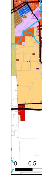
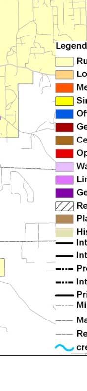
2 Land Use, Texarkana, TX In 2007, the city of Texarkana, TX updated their comprehensive plan and provided guidelines for how the city and its residents desire to facilitate growth in the next 20 to 30 years, which is displayed in the Future Land Use Plan Map, Figure 9. The plan defines the city s goals for growth in the following statements 1 : Encourage office park development by defining districts, Resolve existing land use conflicts between residential neighborhoods, Minimize future land use conflicts by implementing zoning policies, and Target future development in strategic locations based upon direction of growth and ability to serve with public utilities. In addition, the city of Texarkana, Texas goals for transportation includes improving the connectivity of streets within the community, and creating alternative transportation options through bikeway and sidewalk networks. As shown in Figure 9, the primary future land use in Texarkana, TX is low density residential, which is highly concentrated in the northern, central and southwest sections of the city. Higher density residential is sparse, but appears in central, northeast and northwest regions. Large industrial zones occur in southeast and southwest portions of the city and retail is concentrated along major transportation corridors such as Interstate 30, Hwy 59, Stateline Blvd, Richmond, Lake Dr, etc. Office and Industrial land uses are located near the new Texas A&M University campus, Texarkana College, and near Summerhill Rd. at Interstate 30. Figure 8: Shaped Signs on State Line Ave. 1 City of Texarkana, 2001 Comprehensive Plan,


3 Figure 9: Texarkana, Texas Future Land Use Map 2007 Zoning, Texarkana, AR Similarly, Texarkana, AR has facilitated growth and development through its comprehensive plan and zoning regulations. Figure 10 shows the current zoning for the city. Goals of Texarkana, AR s comprehensive plan include preserving neighborhood character by restricting incompatible uses, encouragee an environment that is conducive to the needs of families such as allowing parks, churches, 16

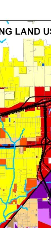

4 schools and playgrounds near communities, and facilitate the movement of businesses and industrial uses to regions of the city that are compatible with adjacent uses. 2 Figure 10: Texarkana, Arkansas Existing Land Use 2 City of Texarkana, AR, ( Ord. No. K 286, 1(Art. II, 3), ) 17


5 As shown in the zoning map, most of the prevailing land use permitted in Texarkana, AR is residential, with only rural residential development allowed on the outer edges of the city. Low and medium density residential zones are dispersed throughout the city. However, industrial zones are concentrated in central east and north central east Texarkana, AR. Small areas of office and quiet business uses are centered in the northwest region and near the central business district. Additionally, open display commercial zones are permitted along major street corridors such as East St., Hwy 67 and Interstatee Attractors and Barriers to Bicycling and Walking In developing a bicycle and pedestrian plan the basis of the plan is wheree bicyclists and walkers want to go and what is preventing them from getting there. The attractors identified in the Texarkanaa area include: schools (elementary to university), parks, community centers, the library, the Boys and Girls Club, Central Mall and other shopping centers, major medical and rehabilitation centers, the movie theatre, the bus and train stations, bus stops and the transfer center, cultural centers, and tourist destinations. Barriers to bicycling and walking include the interstate highway, creeks and railroad tracks. The results of the barriers and attractors inventory are presented in Figure 12. A complete list of pedestrian and bicycle attractors included in this inventory is provided in Appendix C. Figure 11: Pedestrian amenities in downtown Texarkana 18


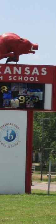
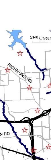
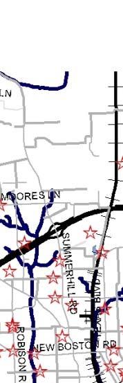
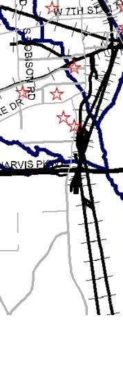
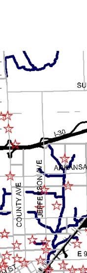
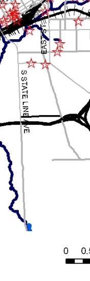
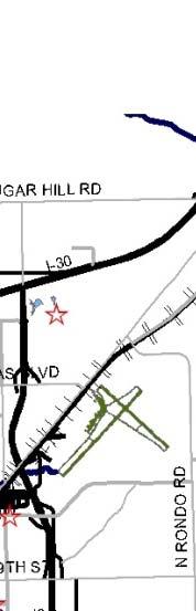
6 Figure 12: Non Motorized Barriers and Attractors Figure 13: A local pedestrian generator Arkansas High School, Texarkana 19


7 2.4 Infrastructure Inventory Over the years Texarkana has acquired various pieces of a non motorized transportation system. However, some elements have deteriorated over time, new standards have been adopted at the national level, and the various pieces are not connected into a comprehensive system. A complete infrastructure inventory should include: multi use trails, sidewalks, bike lanes, shared lanes, our foot wide shoulders, crosswalks, bike sensitive loops, and pedestrian and bicycle related signs. Sidewalks in Texarkanaa have been built sporadically over the past several decades. Many of the existing sidewalkss are narrow and some are so heavily broken they may not be safe for someone using a walker or other assistive device. However, their presence does indicate where there is right of way available for non motorized modes. The only bike lanes observed are where the Nix Creek Trail crosses streets and people are obliged to cross the creek because the trail continues along the other side. Many of the rural highways have four foot shoulders and local bicyclists have identified routes along those highways which are most bicycle friendly. The newest additions to the non motorized transportation system in Texarkana are multi use trails in several parks and along Nix Creek. An initial inventory of sidewalks was performed using aerial photography that allows one to see objects as small as four inches. A preliminary assessment of the condition of the sidewalks was done in person. While none of the sidewalks that were part of the initial detailed inventory were as wide as currently recommended, they weree found to be in varying states of repair. Some lengths are in good shape while others are crumbling and being encroached upon by nearby vegetation (see Figure 12.). Detailed inventories will have greater benefit when conducted prior to a specific project s final cost estimation. This presence/absence inventory of sidewalk does indicate the presence of right of way. The preliminary infrastructure inventory also included identification of roads with a four foot or wider shoulder. At the time this Plan was Figure 14: Sidewalk along New Boston Rd. in Texarkana, Texas being produced the City of Texarkana, Arkansas was repainting crosswalks, therefore a preliminary inventory showing which intersections have crosswalkss and 20


8 pedestrian friendly signals was available. A detailed inventory before design of a specific project will be necessary to determine which specific streets at an intersection have crosswalks. An infrastructure inventory should also include pedestrian and bicycle related signs. Existing trails, sidewalks, four foot wide shoulders and intersections with crosswalks are shown in Figure 17. An inventory of existing and potential infrastructure revealed a bridge over US 59 that has never been used (see Figure 15) ). This bridge was built along railroad right of way that was never developed for its intended purpose. The bridge provides a grade separatethat could be the crossing exclusive use of non motorized traffic. The railroad right of way intended for this bridge is not the only railroad right of or no way that is abandoned longer in use. A stretch of rail from the southwest side of downtown Figure 15: Unused bridge over US 59 in Texarkana, Texas and headed towards Shreveport is also potentially available for non railroad purposes. Another important part of an inventory is the identification of desire lines. Thesee are paths worn throughh vegetated areas indicating where people are walking despite a lack in infrastructure as shown in Figure 16. This could be considered existing or latent demand for infrastructure. A comprehensive inventory was not conducted for this initial plan. Figure 14 shows an example of a desire line. An assessment of other infrastructure related to bicycles indicates that bicycle racks are available on all T Line buses. Bicycle parking facilities are not known to be available anywhere in the Texarkana area. Figure 18 showss the multimodal infrastructure in the Texarkana area. Figure 16: Desire line in grass to bus stop on E. 4th by Spruce Street 21
9 [Figure 17: Existing Infrastructure in Texarkana] 22
10 [Figure 18: Existing mutlimodal infrastructure in Texarkana] 23
Texarkana Bicycle and Pedestrian Master Plan
 September 2009 Prepared by Alliance Transportation Group, Inc. Texarkana Metropolitan Planning Organization The world is run by those who show up Cities of Texarkana, AR Texarkana, TX Wake Village, TX
Sales and Use Transportation Tax Implementation Plan
 Sales and Use Transportation Tax Implementation Plan Transportation is more than just a way of getting from here to there. Reliable, safe transportation is necessary for commerce, economic development,
Chapter 7: Corridor Visions
 Chapter 7: Corridor Visions (see also Appendix 7 for Details) January 24, 2008 NOTE: This document has been prepared using Federal funding from the United States Department of Transportation. The United
2.0 Development Driveways. Movin Out June 2017
 Movin Out June 2017 1.0 Introduction The proposed Movin Out development is a mixed use development in the northeast quadrant of the intersection of West Broadway and Fayette Avenue in the City of Madison.
Utilizing GIS Models in Prioritizing and Selecting Transportation Projects
 Utilizing GIS Models in Prioritizing and Selecting Transportation Projects GIS-T Conference Raleigh, NC April 7, 2016 Tyler Meyer, AICP Tram Truong, GISP Outline Case Studies: 1. MPO project selection
APPENDIX VMT Evaluation
 APPENDIX 2.7-2 VMT Evaluation MEMORANDUM To: From: Mr. Jonathan Frankel New Urban West, Incorporated Chris Mendiara LLG, Engineers Date: May 19, 2017 LLG Ref: 3-16-2614 Subject: Villages VMT Evaluation
CORE AREA SPECIFIC PLAN
 only four (A, B, D, and F) extend past Eighth Street to the north, and only Richards Boulevard leaves the Core Area to the south. This street pattern, compounded by the fact that Richards Boulevard is
Making Mobility Better, Together
 Making Mobility Better, Together Austin Transportation Department Gordon Derr, P.E., for Robert J. Spillar, P.E Director, Austin Transportation Department 1 AUSTIN TRANSPORTATION DEPARTMENT Our Mission
Harlem Avenue between 63 rd and 65 th
 Harlem Avenue between 63 rd and 65 th Public Meeting #2 March 13, 2018 Summit Park District Welcome to the second Public Meeting for the preliminary engineering and environmental studies of Illinois 43
1 Downtown LRT Connector: Draft Concept
 Downtown LRT Connector: Draft Concept Plan November 2010 We re moving forward. Get involved. On June 21, 2010, City Council approved a street-level downtown LRT route, including a connector for the future
Brainstormed Solutions - Passenger
 1-1a Air / Exand: Expand capacity (runway lengths) at BG airport (LOW) find solution! 1-1b Air / fuel: Improve fuel availabilty and reduce cost (LOW) Sound Walls X X X Reduce scatter lighting - more focused
Transportation. Background. Transportation Planning Goals. Level of Service Analysis 5-1
 Transportation portion of the city s stormwater utility, and state road and fuel taxes. Background The transportation needs of the City of Lacey and its planning areas are met by a growing multimodal network
2 EXISTING ROUTE STRUCTURE AND SERVICE LEVELS
 2 EXISTING ROUTE STRUCTURE AND SERVICE LEVELS In the Study Area, as in most of the Metro Transit network, there are two distinct route structures. The base service structure operates all day and the peak
Fresno County. Sustainable Communities Strategy (SCS) Public Workshop
 Public Workshop") Fresno County Sustainable Communities Strategy (SCS) Public Workshop Project Background Senate Bill 375 Regional Transportation Plan (RTP) Greenhouse gas emission reduction through integrated transportation
Fresno County Sustainable Communities Strategy (SCS) Public Workshop Project Background Senate Bill 375 Regional Transportation Plan (RTP) Greenhouse gas emission reduction through integrated transportation
Bi-County Transitway/ Bethesda Station Access Demand Analysis
 Bi-County Transitway/ Bethesda Station Access Demand Analysis Prepared for: Washington Metropolitan Area Transit Authority Office of Planning and Project Development May 2005 Prepared by: in conjunction
SUPPORTING TOD IN METRO CHICAGO
 www.rtachicago.org SUPPORTING TOD IN METRO CHICAGO Tuesdays at APA November 18, 2014 OVERVIEW OF RTA 2 11/18/2014 Tuesdays at APA: Supporting TOD in Metro Chicago RTA Region 8.5 million people 3,700 square
Metra Milwaukee District West Line Transit-Friendly Development Plan
 Metra Milwaukee District West Line Transit-Friendly Development Plan Community Input Workshop April 6, 2011 Overview of Presentation Workshop Goals Study Context Existing Conditions Market Overview Employment
Parking Management Element
 Parking Management Element The State Transportation Planning Rule, adopted in 1991, requires that the Metropolitan Planning Organization (MPO) area implement, through its member jurisdictions, a parking
Citizens Committee for Facilities
 Citizens Committee for Facilities AGENDA Thursday, December 11, 2014 City Council Chambers 305 3 rd Avenue East -Twin Falls, Idaho 11:30 A.M. AGENDA ITEMS Purpose By 1. Discussion and possible action on
Revised Evaluation Scores. System Preservation
 Revised Evaluation s System Preservation This page provides a summary of any revisions made to the draft scores presented at the October th Attributable Funds mmittee meeting. The information below highlights
EUGENE-SPRINGFIELD, OREGON EAST WEST PILOT BRT LANE TRANSIT DISTRICT
 EUGENE-SPRINGFIELD, OREGON EAST WEST PILOT BRT LANE TRANSIT DISTRICT (BRIEF) Table of Contents EUGENE-SPRINGFIELD, OREGON (USA)... 1 COUNTY CONTEXT AND SYSTEM DESCRIPTION... 1 SYSTEM OVERVIEW... 1 PLANNING
Building our future, together. Steering Committee Presentation for the Comprehensive Plan Update April 23, 2013
 Building our future, together Steering Committee Presentation for the Comprehensive Plan Update April 23, 2013 Vision In 2030, the City of Tyler will be nationally known for its commitment to community,
Downtown Lee s Summit Parking Study
 Downtown Lee s Summit Parking Study As part of the Downtown Lee s Summit Master Plan, a downtown parking and traffic study was completed by TranSystems Corporation in November 2003. The parking analysis
Appendix A. Community Workshop Results PUBLIC REVIEW DRAFT
 Appendix A Community Workshop Results This Page Left Blank Intentionally Comprehensive Planning Community Workshop Summary July 30, 2012 The City of Becker invited the Community to participate in a Comprehensive
Green Line Long-Term Investments
 Enhancements Short-term improvements to keep Austin moving. Investments Long-term projects to support our future. Mobility Hubs MetroRapid MetroRail MetroExpress Connectors Circulators Project Connect
Appendix C. Parking Strategies
 Appendix C. Parking Strategies Bremerton Parking Study Introduction & Project Scope Community concerns regarding parking impacts in Downtown Bremerton and the surrounding residential areas have existed
Town of Londonderry, New Hampshire NH Route 28 Western Segment Traffic Impact Fee Methodology
 Town of Londonderry, New Hampshire NH Route 28 Western Segment Traffic Impact Fee Methodology Prepared by the Londonderry Community Development Department Planning & Economic Development Division Based
Major Widening/New Roadway
 Revised Evaluation s Major Widening/New Roadway This page provides a summary of any revisions made to the draft scores presented at the October th Attributable Funds Committee meeting. The information
I-820 (East) Project Description. Fort Worth District. Reconstruct Southern I-820/SH 121 Interchange
 Project Description. Fort Worth District. Reconstruct Southern I-820/SH 121 Interchange") I-820 (East) Project Description Fort Worth District Reconstruct Southern I-820/SH 121 Interchange I-820 from approximately 2,000 feet north of Pipeline Road/Glenview Drive to approximately 3,200 feet
I-820 (East) Project Description Fort Worth District Reconstruct Southern I-820/SH 121 Interchange I-820 from approximately 2,000 feet north of Pipeline Road/Glenview Drive to approximately 3,200 feet
Yonge-Eglinton. Mobility Hub Profile. September 19, 2012 YONGE- EGLINTON
 September 19, 2012 PEEL YORK HALTON DURHAM HAMILTON TORONTO YONGE- EGLINTON MOBILITY HUBS: places of connectivity between regional and rapid transit services, where different modes of transportation come
Subarea Study. Manning Avenue (CSAH 15) Corridor Management and Safety Improvement Project. Final Version 1. Washington County.
 Corridor Management and Safety Improvement Project. Final Version 1. Washington County.") Subarea Study Manning Avenue (CSAH 15) Corridor Management and Safety Improvement Project Final Version 1 Washington County June 12, 214 SRF No. 138141 Table of Contents Introduction... 1 Forecast Methodology
Subarea Study Manning Avenue (CSAH 15) Corridor Management and Safety Improvement Project Final Version 1 Washington County June 12, 214 SRF No. 138141 Table of Contents Introduction... 1 Forecast Methodology
APPENDIX H. Transportation Impact Study
 APPENDIX H Transportation Impact Study BUENA VISTA LAGOON ENHANCEMENT PROJECT TRANSPORTATION IMPACT STUDY Prepared for: San Diego Association of Governments Prepared by: VRPA Technologies, Inc. 9520 Padgett
LEED v4 Building Design and Construction Quiz #3 LT
 LEED v4 Building Design and Construction Quiz #3 LT 1. How are walking and bicycling distance measured? A. Straight-line radius from a main building entrance B. Straight-line radius from any building entrance
Tulsa Transportation Management Area. Urbanized Area Surface Transportation Program
 Tulsa Transportation Management Area Urbanized Area Surface Transportation Program FFY 2022 Application Information Sponsor Location Description STP Request Other Funds Broken Arrow Elm Place: Kenosha
Transit Hub Case Study: Owings Mills Metro Station. By: Kathleen Cary Rose, J. Luke Byrne and Catherine Buhler
 Executive Summary Transit Hub Case Study: Owings Mills Metro Station By: Kathleen Cary Rose, J. Luke Byrne and Catherine Buhler The purpose of the Transit Hub Case Study is to identify and evaluate the
STRATEGIC PRIORITIES AND POLICY COMMITTEE MAY 5, 2016
 STRATEGIC PRIORITIES AND POLICY COMMITTEE MAY 5, 2016 Shift Rapid Transit Initiative Largest infrastructure project in the city s history. Rapid Transit initiative will transform London s public transit
CITY OF VANCOUVER ADMINISTRATIVE REPORT
 Supports Item No. 1 T&T Committee Agenda May 13, 2008 CITY OF VANCOUVER ADMINISTRATIVE REPORT Report Date: April 29, 2008 Author: Don Klimchuk Phone No.: 604.873.7345 RTS No.: 07283 VanRIMS No.: 13-1400-10
Environmental Assessment Derry Road and Argentia Road Intersection
 Air and Noise Study Environmental Assessment Derry Road and Argentia Road Intersection Project 11-4295 City of Mississauga, Region of Peel October 17, 2014 1 Region of Peel Environmental Assessment for
CTA Blue Line Study Area
 CTA Blue Line Study Area HISTORY OF THE CTA BLUE LINE / I-290 SYSTEM Blue Line / I-290 infrastructure is 55 years old First integrated transit / highway facility in the U.S. PROJECT STUDY AREA EXISTING
Develop ground transportation improvements to make the Airport a multi-modal regional
 Project Overview TRANSPORTATION IMPROVEMENTS WHAT ARE THE PROJECT GOALS? Transportation transportation hub. Develop ground transportation improvements to make the Airport a multi-modal regional Land Use
Purpose and Need Report
 Purpose and Need Report State Highway (SH) 29 From Southwestern Boulevard to SH 95 Williamson County, Texas (CSJ: 0337-02-045) Prepared by Blanton & Associates, Inc. Date: November, 2015 The environmental
The Eastern Connector Study November, 2007 planning for the future
 The Eastern Connector Study November, 2007 planning for the future In late 2006, Albemarle County and the City of Charlottesville jointly initiated the Eastern Connector Corridor Study. The Project Team
Click to edit Master title style
 Nelson/Nygaard Consulting Associates SERVICE IMPROVEMENT STRATEGIES September 22, 2015 1 PROJECT OVERVIEW & WORK TO DATE 1. Extensive stakeholder involvement Throughout 2. System and market assessment
Central Loop Bus Rapid Transit
 Central Loop Bus Rapid Transit Transportation Goals of the Chicago Central Area ACTION Plan, page 2-6 Central Area Plan Improve Transit in Central Area Improve Pedestrian Environment Manage Traffic Circulation
Office of Transportation Bureau of Traffic Management Downtown Parking Meter District Rate Report
 Office of Transportation Bureau of Traffic Management 1997 Downtown Parking Meter District Rate Report Introduction The City operates approximately 5,600 parking meters in the core area of downtown. 1
Downtown Transit Connector. Making Transit Work for Rhode Island
 Downtown Transit Connector Making Transit Work for Rhode Island 3.17.17 Project Evolution Transit 2020 (Stakeholders identify need for better transit) Providence Core Connector Study (Streetcar project
Findings from the Limassol SUMP study
 5 th European Conference on Sustainable Urban Mobility Plans 14-15 May 2018 Nicosia, Cyprus Findings from the Limassol SUMP study Apostolos Bizakis Deputy PM General Information The largest city in the
Attachment 5 Eglinton West LRT Planning and Technical Update
 Eglinton West LRT Planning and Technical Update 1. Introduction In July 2016, City Council approved an Eglinton West LRT with between 8 and 12 stops between Mount Dennis and Renforth Gateway, and up to
Address Land Use Approximate GSF
 M E M O R A N D U M To: Kara Brewton, From: Nelson\Nygaard Date: March 26, 2014 Subject: Brookline Place Shared Parking Analysis- Final Memo This memorandum presents a comparative analysis of expected
CEDAR AVENUE TRANSITWAY Implementation Plan Update
 CEDAR AVENUE TRANSITWAY Implementation Plan Update EECUTIVE SUMMARY DECEMBER 2015 Executive Summary In 2013, the Twin Cities metropolitan area s first bus rapid transit (BRT) line, the METRO Red Line,
PUBLIC TRANSPORTATION
 PUBLIC TRANSPORTATION PROJECT TITLE U-MED DISTRICT MULTI-MODAL IMPROVEMENTS- PHASE II Transit Vehicles and Upgrades MUNICIPALITY OF ANCHORAGE Capital Improvement Program PROJECT LIST BY DEPARTMENT Public
South Lexington Transportation Study Lexington, Massachusetts
 South Lexington Transportation Study Lexington, Massachusetts Preliminary Findings and Options for Consideration Businesses Meeting 10/10/13 Town of Lexington Engineering and Planning Departments Meeting
Highway 18 BNSF Railroad Overpass Feasibility Study Craighead County. Executive Summary
 Highway 18 BNSF Railroad Overpass Feasibility Study Craighead County Executive Summary October 2014 Highway 18 BNSF Railroad Overpass Feasibility Study Craighead County Executive Summary October 2014 Prepared
/ Planning and Zoning Staff Report Lonestar Land, LLC. - Rezone, RZ
 / Planning and Zoning Staff Report Lonestar Land, LLC. - Rezone, RZ2018-0019 Hearing Date: October 18, 2018 Development Services Department Applicant: Lonestar Land, LLC. Representative: Lance Warnick
FREQUENTLY ASKED QUESTIONS
 FREQUENTLY ASKED QUESTIONS 2018 What is the More MARTA Atlanta program? The More MARTA Atlanta program is a collaborative partnership between MARTA and the City of Atlanta to develop and implement a program
Stadium Expansion Parking Plan and Transportation Management Program
 University of Washington Stadium Expansion Parking Plan and Transportation Management Program 2001 Data Collection Summary Contents Background... Introduction... Executive Summary... TMP Elements... Transit
BROWARD BOULEVARD CORRIDOR TRANSIT STUDY
 BROWARD BOULEVARD CORRIDOR TRANSIT STUDY FM # 42802411201 EXECUTIVE SUMMARY July 2012 GOBROWARD Broward Boulevard Corridor Transit Study FM # 42802411201 Executive Summary Prepared For: Ms. Khalilah Ffrench,
VIII. INFORMATION ABOUT BROKERAGE SERVICES
 TABLE OF CONTENTS I. ELEVATION SITE PLAN & CONCEPTUAL II. AERIAL OVERVIEW III. PROPERTY INFORMATION IV. LOCATION MAPS V. CITY AND AREA INFORMATION VI. DEMOGRAPHICS VII. DISCLAIMER AGENCY DISCLOSURE VIII.
Report Date: May 18, 2012 Contact: Al Zacharias Contact No.: RTS No.: 9587 VanRIMS No.: Meeting Date: June 12, 2012
 A5 ADMINISTRATIVE REPORT Report Date: May 18, 2012 Contact: Al Zacharias Contact No.: 604.873.7214 RTS No.: 9587 VanRIMS No.: 08-2000-21 Meeting Date: June 12, 2012 TO: FROM: SUBJECT: Vancouver City Council
Purpose of Tonight s Meeting
 Purpose of Tonight s Meeting Point Dume Neighborhood Traffic Calming Project background, goals Resident Safety Concerns Existing Conditions Fact Sheets Map of Proposed Improvements Discussion Next Steps
Metro Transit Update. Christina Morrison, Senior Planner Metro Transit BRT/Small Starts Project Office. John Dillery, Senior Transit Planner
 Metro Transit Update Christina Morrison, Senior Planner Metro Transit BRT/Small Starts Project Office John Dillery, Senior Transit Planner Metro Transit Service Development May 16, 2013 1 Transit Planning
EXCEPTION TO STANDARDS REPORT
 EXCEPTION TO STANDARDS REPORT PROJECT DESCRIPTION AND NEED The project is located in Section 6, Township 23 North, Range 9 East and Section 31 Township 24 North, Range 9 East, in the Town of Stockton,
Slow Down! Why speed is important in realizing your Vision Zero goals and how to achieve the speeds you need
 Slow Down! Why speed is important in realizing your Vision Zero goals and how to achieve the speeds you need Lake McTighe, METRO Joel McCarroll, ODOT Jenna Marmon, ODOT Matt Ferris-Smith, PBOT Oregon Active
4 Circulation & Transportation
 4.1 Mobility Network The mobility network at the new St. Paul s hospital and health campus is comprised of an interconnected system of sidewalks, cycle paths, transit routes and roadways. Figure 4-1: Indicative
2030 Multimodal Transportation Study
 2030 Multimodal Transportation Study City of Jacksonville Planning and Development Department Prepared by Ghyabi & Associates April 29,2010 Introduction Presentation Components 1. Study Basis 2. Study
Otay Ranch Station 2020 MOBILITY SERVICES MAP REGIONAL MOBILITY HUB IMPLEMENTATION STRATEGY
 MAGDALENA REGIONAL MOBILITY HUB IMPLEMENTATION STRATEGY Otay Ranch Station Mobility hubs are transportation centers located in smart growth areas served by high frequency transit service. They provide
11 October 12, 2011 Public Hearing APPLICANT:
 11 October 12, 2011 Public Hearing APPLICANT: CARING TRANSITIONS PROPERTY OWNER: HARDEE REALTY CORPORATION REQUEST: Conditional Use Permit (motor vehicle rental) STAFF PLANNER: Leslie Bonilla ADDRESS /
Dixie Transportation Planning Office
 A project must be given a yes rating on items 1 & 2 in order to be prioritized. Sponsor: St. George City Project: Pioneer Parkway Type: Road Widening and Reconstruction Rev. 9/17/2010 Dixie Transportation
BUS STOP DESIGN & PLANNING GUIDE
 BUS STOP DESIGN & PLANNING GUIDE Prepared by the Operations and Planning Departments 2011 PURPOSE OF GUIDE The design of passenger waiting areas plays a significant role in a person s decision of whether
TRANSPORTATION REVIEW
 TRANSPORTATION REVIEW - PROPOSED MIX OF LAND USES IS CONSISTENT WITH THE CITY S UNDER THE GRANVILLE BRIDGE POLICIES THAT AIM TO MEET NEIGHBOURING RESIDENTS SHOPPING NEEDS AND REDUCE RELIANCE ON AUTOMOBILE
Station Evaluation Summary
 Station Evaluation Summary Preferred Site Location 10/1/00 Loop 1 Station Points 70 Key Issues: Potential Master Plan Development suggests a strong economic development potential for the larger property
TRANSPORTATION PLANNING PERFORMANCE MEASUREMENT USING GIS
 TRANSPORTATION PLANNING PERFORMANCE MEASUREMENT USING GIS TYLER MEYER, AICP 2015 AMPO Conference Clark County, NV October 2015 Overview Transportation Alternatives Program (TAP) overview MPO TAP Scoring
POLICIES OF COLORADO STATE UNIVERSITY UNIVERSITY POLICY. Draft PURPOSE OF THIS POLICY
 POLICIES OF COLORADO STATE UNIVERSITY UNIVERSITY POLICY Policy Title: Service Carts Policy ID # 5-6030-013 Effective Date: Category: 5. Administration Policy Owner: Vice President for University Operations
Madison BRT Transit Corridor Study Proposed BRT Operations Plans
 Madison BRT Transit Corridor Study Proposed BRT Operations Plans This paper presents a description of the proposed BRT operations plan for use in the Madison BRT Transit Corridor Study. The objective is
2. Valley Circle Boulevard/Andora Avenue/Baden Avenue and Lassen Street
 IV.J TRANSPORTATION 1. INTRODUCTION This section presents an overview of the existing traffic and circulation system in and surrounding the project site. This section also discusses the potential impacts
PUBLIC INFRASTRUCTURE PROJECTS
 PUBLIC INFRASTRUCTURE PROJECTS FM 664 / OVILLA ROAD WIDENING & IMPROVEMENTS FM 664 / OVILLA ROAD CONNECTS US 287 WITH I-45 (SOURCE: TEXAS DEPARTMENT OF TRANSPORTATION. 2016 FM 664 / OVILLA ROAD WIDENING
CITY OF DECATUR, TEXAS Development Services 1601 S. State Street Decatur, TX (940) voice (940) fax
 voice (940) fax") CITY OF DECATUR, TEXAS Development Services 1601 S. State Street Decatur, TX 76234 (940) 393-0250 voice (940) 626-4629 fax AGENDA Planning and Zoning Commission and City Council Joint Workshop* Monday,
CITY OF DECATUR, TEXAS Development Services 1601 S. State Street Decatur, TX 76234 (940) 393-0250 voice (940) 626-4629 fax AGENDA Planning and Zoning Commission and City Council Joint Workshop* Monday,
Location Concept Plan Amendment Recommendation Approved 2011 Concept Plan
 Valley Line West LRT Concept Plan Recommended Amendments Lewis Farms LRT Terminus Site Location Concept Plan Amendment Recommendation Approved 2011 Concept Plan Lewis Farms LRT terminus site, 87 Avenue/West
Dallas Area Rapid Transit (DART) Cotton Belt Regional Rail Project
 Cotton Belt Regional Rail Project") Dallas Area Rapid Transit (DART) Cotton Belt Regional Rail Project Kick-Off Meeting - Richardson and Plano Community Stakeholders Richardson Civic Center March 28, 2019 0 How to Stay Informed Visit www.dart.org/cottonbelt
Dallas Area Rapid Transit (DART) Cotton Belt Regional Rail Project Kick-Off Meeting - Richardson and Plano Community Stakeholders Richardson Civic Center March 28, 2019 0 How to Stay Informed Visit www.dart.org/cottonbelt
Section III Transportation and Stormwater Projects Receiving Additional Funding Project Detail Sheets Alphabetical Listing by Project Name Five Year
 Section III Transportation and Stormwater Projects Receiving Additional Funding Project Detail Sheets Alphabetical Listing by Project Name Five Year Capital Improvement Plan FY2015/2016 through FY2020
6/6/2018. June 7, Item #1 CITIZENS PARTICIPATION
 June 7, 2018 Item #1 CITIZENS PARTICIPATION 1 Item #2 APPROVAL OF MINUTES Item #3 TRAC GOALS, FRAMEWORK & AGENDA REVIEW 2 COMMITTEE GOALS Learn about Southern Nevada s mobility challenges, new developments
STH 60 Northern Reliever Route Feasibility Study Report
 #233087 v3 STH 60 Northern Reliever Route Feasibility Study Report Washington County Public Works Committee Meeting September 28, 2016 1 STH 60 Northern Reliever Route Feasibility Study Hartford Area Development
Demographics and Sales
 Demographics and Sales What is an E-Bike? Almost identical to a traditional bicycle in appearance Small electric motor and battery to provide motorized assistance (pedal or throttle), up to 750 w (the
SUSTAINABILITY CODE AMENDMENTS ELECTRICAL VEHICLE INFRASTRUCTURE AND BICYCLE PARKING DRAFT
 SUSTAINABILITY CODE AMENDMENTS ELECTRICAL VEHICLE INFRASTRUCTURE AND BICYCLE PARKING DRAFT Planning Commission January 8, 2014 Electric Vehicle Parking Purpose: To ensure infrastructure readiness for electric
Redefining Mobility Ready or not: Autonomous and connected vehicle planning and policy, now and in the future
 Redefining Mobility Ready or not: Autonomous and connected vehicle planning and policy, now and in the future Randy Iwasaki November 30, 2017 WHO WE ARE The Contra Costa Transportation Authority (CCTA)
Spatial planning and sustainable urban transport systems
 Jean-Christophe Goudouneix Rita Magris Laura Richter Nicolae Serban Stef Tomesen George Yates Erasmus Intensive Programme 2013 Oradea Group 4 Spatial planning and sustainable urban transport systems Developing
IMPROVEMENT CONCEPTS
 IMPROVEMENT CONCEPTS for the South Novato Transit Hub Study Prepared by: January 11, 2010 DKS Associates With Wilbur Smith Associates IMPROVEMENT CONCEPTS Chapter 1: Introduction 1. INTRODUCTION The strategic
Transportation Sustainability Program
 Transportation Sustainability Program Photo: Sergio Ruiz San Francisco 2016 Roads and public transit nearing capacity Increase in cycling and walking despite less than ideal conditions 2 San Francisco
PLANNING JUSTIFICATION REPORT ZONING AMENDMENT
 PLANNING JUSTIFICATION REPORT ZONING AMENDMENT Proposed Expansion of Mercedes-Benz Motor Vehicle Dealership 441 North Service Road, Burlington, Ontario December 2016 Prepared for: Mr. Ken Szekely Quantum
Traffic Impact Analysis West Street Garden Plots Improvements and DuPage River Park Garden Plots Development Naperville, Illinois
 Traffic Impact Analysis West Street Garden Plots Improvements and DuPage River Park Garden Plots Development Naperville, Illinois Submitted by April 9, 2009 Introduction Kenig, Lindgren, O Hara, Aboona,
Garrett Hill Master Plan
 Garrett Hill Master Plan Visioning Workshop February 13, 2007 Campbell Thomas & Company Agenda Welcome Existing conditions summary Critical issues Visioning exercise Summary & next steps Critical Assets
CHAPTER 2 ZONING AND DEVELOPMENT
 2.200 GENERAL DEVELOPMENT STANDARDS CHAPTER 2 ZONING AND DEVELOPMENT Section 2.201 GENERAL PROVISIONS... 2.2-1 Section 2.202 FENCES AND VISIONS CLEARANCE... 2.2-2 2.202.01 Fences... 2.2-2 2.202.02 Vision
Rocky Mount. Transportation Plan. Transportation Planning Division. Virginia Department of Transportation
 2020 Transportation Plan Developed by the Transportation Planning Division of the Virginia Department of Transportation in cooperation with the U.S. Department of Transportation, Federal Highway Administration
Station Evaluation. Durham-Orange Light Rail Transit Project Spring 2012
 Station Evaluation Durham-Orange Light Rail Transit Project Spring 2012 Key Ingredients for Station Development Platform Designs UNC Hospitals Station The UNC Hospitals Station Option D would be the westerly
EXECUTIVE SUMMARY. Introduction
 EXECUTIVE SUMMARY Introduction The purpose of this study is to ensure that the Village, in cooperation and coordination with the Downtown Management Corporation (DMC), is using best practices as they plan
Traffic Management Plan and Queuing Analysis Lakehill Preparatory School Z Hillside Drive, Dallas, TX October 27, 2015
 Traffic Management Plan and Queuing Analysis Lakehill Preparatory School Z145-235 2720 Hillside Drive, Dallas, TX October 27, 2015 Introduction: The Lakehill Preparatory School is located on the northeast
Stoughton Center Parking
 Stoughton Center Parking Existing Conditions and Observations October 4, 2017 Agenda Introduction Metropolitan Area Planning Council Project Team Parking Studies Background Scope of Work Study Area Survey
Letter EL652 City of Mercer Island. Page 1. No comments n/a
 Letter EL652 City of Mercer Island Page 1 No comments n/a Page 2 Response to comment EL652 1 Section 4.5.3 of the Final EIS presents the range of potential impacts of the project. This project also lists
Sustainability SFMTA Path to Platinum
 Sustainability SFMTA Path to Platinum Ed Reiskin San Francisco Municipal Transportation Agency, Director of Transportation San Francisco, CA Timothy Papandreou Deputy Director Strategic Planning & Policy
Multnomah County Commission December 15, 2016
 Powell-Division Transit and Development Project Multnomah County Commission December 15, 2016 POWELL-DIVISION TRANSIT AND DEVELOPMENT PROJECT A partnership of Metro, TriMet, the cities of Portland and