Texarkana Bicycle and Pedestrian Master Plan
|
|
|
- Jacob King
- 5 years ago
- Views:
Transcription
1 September 2009 Prepared by Alliance Transportation Group, Inc.
2 Texarkana Metropolitan Planning Organization The world is run by those who show up Cities of Texarkana, AR Texarkana, TX Wake Village, TX Nash, TX Miller County, AR Bowie County, TX "The preparation of this report has been financed in part through grant[s] from the Federal Highway Administration and Federal Transit Administration, U.S. Department of Transportation, under the State Planning and Research Program, Section 505 [or Metropolitan Planning Program, Section 104(f)] of Title 23, U.S. Code. The contents of this report do not necessarily reflect the official views or policy of the U.S. Department of Transportation."
3 Table of Contents Executivee Summary Origin of the Plan Federal and National Guidance Local, Regional, and National Influences Benefits of Having a Plan Potential Future Demand Priorities from Public Meetings Vision for the Texarkana Area Definitions/Acronyms Assessment of Current Conditions and Needs Current Nonmotorized Mode Share and Safety Land Use and Zoning in Texarkana Attractors and Barriers to Bicycling and Walking Infrastructure Inventory Users of the Non Motorized Transportation System Characteristics of Pedestrians as Travelers Characteristics of Bicyclists as Travelers The Non Motorized Transportation System: Elements and Design Guidelines Elements of the Pedestrian Transportation System Criteria for Choosing Pedestrian Projects Elements of the Bicycle Transportation System Criteria for Choosing Bicycle Transportation System Elements Trails Intersections/Crossings Multimodal Connections Traffic Calming The Plan Elements and Implementation Summary of Recommendations i
4 5.2 Infrastructure Elements of the Master Bicycle and Pedestrian Plan Education Elements of the Bicycle and Pedestrian Master Plan Enforcement Elements of the Bicycle and Pedestrian Master Plan Multimodalism in the Bicycle and Pedestrian Master Plan Evaluation of Progress and Continuing the Plan Potential Funding Sources for the Plan Facility Maintenance Performance Measures APPENDIX A: Average Scores of Project Criteria from Public Meeting APPENDIX B: Public Involvement and Local Press Coverage APPENDIX C: Pedestrian Generators Included in this Plan APPENDIX D: Potential Transportation Infrastructure Upgrades Near Schools APPENDIX E: Sample Ordinance Language ii
5 List of Figures Figure 1: Mockingbird Junction... 2 Figure 2: U.S. Post Office and Courthouse... 4 Figure 3: Sign on Nix Creek Trail, Texarkana, Arkansas... 5 Figure 4: Walkers on the Phillip McDougal Trail in Spring Lake Park, Texarkana, Texas... 6 Figure 5: Mockingbird Junction... 8 Figure 6: Texarkana Non Motorized Conceptual Plan Figure 7: Private Sitting Area (to left) Built to Take Advantage of Nix Creek Trail as Amenity Figure 8: Shaped Signs on State Line Ave Figure 9: Texarkana, Texas Future Land Use Map Figure 10: Texarkana, Arkansas Existing Land Use Figure 11: Pedestrian amenities in downtown Texarkana Figure 12: Non Motorized Barriers and Attractors Figure 13: A local pedestrian generator Arkansas High School, Texarkana Figure 14: Sidewalk along New Boston Rd. in Texarkana, Texas Figure 15: Unused bridge over US 59 in Texarkana, Texas Figure 16: Desire line in grass to bus stop on E. 4th by Spruce Street [Figure 17: Existing Infrastructure in Texarkana] [Figure 18: Existing mutlimodal infrastructure in Texarkana] Figure 19: AASHTO recommended sidewalk width Figure 21: Example of Reduced pedestrian/vehicle conflict points with roundabout Figure 20: Elements of an AASHTO compliant curb ramp Figure 22: Marked and signed pedestrian crossing in Spring Lake Park Figure 23: MUTCD allowed crosswalk markings Figure 24: Grade separated pedestrian crossing over the Kansas City Southern Line in Texarkana, Texas Figure 25: Pedestrian scale light and signs Texarkana, Arkansas Figure 26: Marked bicycle lane on collector street: Figure 27: Typical profiles of streets with bicycle lanes with and without on street parking Figure 28: Example of bicycle rack with an artistic flair Tempe, AZ Figure 29: Example of bike racks shaped like book spines Powell's City of Books, Portland, OR Figure 30: T Line stop across from the Greyhound Station Texarkana, AR Figure 31: Signs to guide pedestrians and bicyclists through a traffic circle Santa Fe, NM Figure 32: Brick crosswalks in downtown Texarkana Figure 33: Ideal downtown sidewalk with amenities and access to transitt that do not interfere with the pedestrian path Figure 34: Ramp without sidewalkss Whitaker and MLK, Texarkana, Texas [Figure 35: Proposed Texarkana Bicycle Plan] [Figure 36: Proposed Texarkana Pedestrian Plan] Figure 37: Project 627 map iii
6 Figure 38: Project 623 map Figure 39: Projects 604 & 629 map Figure 40: Project 605 map Figure 41: Portion of Pedestrian Corridor PR map Figure 42: Bikeway BW map Figure 43: Example of a Sharrow [Figure 44: Texarkana Area Long Distance Bicycle Routes] Figure 45: Example of public education advertisement regarding bicycle safety Salt Lake County, UT Figure 46: Texarkana Amtrak Station List of Tables Table 1: AASHTO Recommendations for Landscaped Buffer Widths Table 2: Summary of AASHTO Minimum Standards for Elements Table 3: Guidelines for selecting bikeway facilities for all new or reconstructed streets Table 4: Summary of AASHTO minimum standards for elements iv
7 Executive Summary This Master Plan for bicycling and walking in Texarkana is designed to provide a comprehensive vision for non motorized transportation as well as recreation. Having a master plan is a first step towards coordination among the various agencies responsible for transportation and recreation facilities, as well as other interested parties. Bicycling is a popular sport in Texarkana and the area s relatively mild climate allows for bicycling and walking for much of the year. Promotion of bicycling and walking support federal transportation policies to increase the non with motor vehicles by motorized mode share to 15% and decrease bicycling and walking injuries and fatalities due to crashes 10%. The consideration of bicyclists and pedestrians is required in the development of comprehensive plans. Except where prohibited, bicycle and pedestrian facilities are required to be considered in alll new construction and reconstruction projects. Federal guidance suggests that not including bicycle and pedestrian access in federal projects should be the exception and not the rule. Another important consideration is the safety of bicyclists and pedestrianss as commuters. Towards these goals Metropolitan Transportation Plans (MTPs) are required to address the provision of contiguous routes for bicyclists and pedestrians. They must also consider bicycle transportation facilities and pedestrian walkways for all new construction and reconstruction of transportation facilities, unless bicycle use and walking would not be permitted. It is intended that thesee facilities are part of an integrated, multi modal transportation system for the metropolitan planning area. Local, regional, and national activities/plans suggest increased demand for non motorized facilities is in the future. At the local level the City of Texarkana, Texas Parks Department has developed a Parks Master Plan. One goal of the Parks Plan is to link the parks in the city with linear parks. Another goal is to incorporate public art in a variety of public settings. At the regional level the Northeast Texas Recreational Trail is currently designed to go from Farmersville (on the outskirts of the Dallas metropolitan area) 147 miles through Paris, Texas to New Boston 22 miles to the west of Texarkana. At the national level, the American Association of State and Highway Transportation Officials (AASHTO) and the American Cycling Association are presently developing a national numbered Bicycle Route System. Current drafts show Route 84 passing through Texarkana. In addition, Texarkana is on a high for speed rail corridor eligible for federal support. Altogether these activities suggest it is time Texarkanaa to have a master bicycle and pedestrian plan. These planned routes suggest the core of the bicycle and pedestrian plan for the Texarkana area is an exclusive use corridorr coming from New Boston and continuing towards Shreveport. If efforts in Arkansas to have a corridor between Texarkana and Little Rock come to fruition, this suggestss that Texarkana, like its railroad past, is a transportation junctionn connecting the three states that make up the ArkLaTex. As the mockingbird is the state bird of both Texas and Arkansas, this backbone of the plan shall be referred to as Mockingbird Junction (seee Figure 1). 1


8 Figure 1: Mockingbird Junction Texarkanaa has many pieces of a bicycle and pedestrian transportation system, but the pieces are scattered and in some cases in serious disrepair. This Plan provides an initial inventory of relevant infrastructure and suggests other inventory activities that need to take place. The Plan then includes specific projects to connect and rebuild the pieces of the bicycle and pedestrian system. In addition, the following recommendations are included. Establish a Bicycle and Pedestrian Advisory Panel to continue updating and implementing this plan. This panel should include representation from: o Transit o Public works/engineer o Parks departments o School districts 2
9 o The disabled community Include bicycle and pedestrian infrastructure when rebuilding/rehabilitating roads Increase enforcement of traffic laws related to bicyclists and pedestrians Include a minimum of 4 of clear path (i. e., no rumble strip) on designated highway shoulders Work with the parks departments on Art in Public Places for bike racks and local branding Make easements more inclusive so they include ability for bicycle and pedestrian access (where appropriate) Build sidewalks (internal circulation) and connectivity in new subdivisions Ensure that traffic calming measures do not extend into bicycle lanes (or to edge of lane in wide curb lanes for mixed use) Conduct an inventory of: o Utility easements o Right of Way on streets (for sidewalks) and railroads o Roads with wide enough lanes to restripe and add a bike lane o Abandoned railroad right of way Work with the police departments to collect meaningful, easily accessible bicycle and pedestrian crash data (perhaps produce an annual report perhaps work with a class at TAMU T or Texarkana College regarding data analysis) Install new yellow green fluorescent (YGF) signs around schools Maintain (clean) highway shoulders on bike routes on a regular basis (similarly, provide a mechanism so bicyclists can report debris and other problems) Educate the public about bicycles and motor vehicles sharing the road Educate the public regarding children bicycling and walking to school Conduct a bicycle parking inventory and identify places to include bicycle parking (such as parks, shopping centers, and schools) Improve the T Line bus stop across from the Greyhound Station Provide bicycle and pedestrian access at the crossings periodically around the proposed outer loop. The following locations are recommended: o Sugar Hill Rd. o Sanderson Ln. o State Line Ave. o FM 1397 (both locations) o FM 559 o Myrtle Springs Rd. o I 30 o Gold Finch Rd. o SH 67 o FM 1225 o SH 59 Add projects and corridors to MTP 3


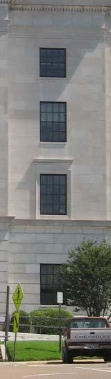
10 Restripe Cowhorn Creek Bridge to include bicycle lanes Develop Safe Routes to School plan in each school district Figure 2: U.S. Post Office and Courthouse 4
residents of data near walking. related to bicycling and Safety According available. available. 2.2 Land adopted by
 2. Assessment of Current Conditions and Needs In order to prepare a plan to reach the vision desired by the residents of Texarkana, it is first necessary to ascertain the current situation. Since there
BROWARD BOULEVARD CORRIDOR TRANSIT STUDY
 BROWARD BOULEVARD CORRIDOR TRANSIT STUDY FM # 42802411201 EXECUTIVE SUMMARY July 2012 GOBROWARD Broward Boulevard Corridor Transit Study FM # 42802411201 Executive Summary Prepared For: Ms. Khalilah Ffrench,
Sales and Use Transportation Tax Implementation Plan
 Sales and Use Transportation Tax Implementation Plan Transportation is more than just a way of getting from here to there. Reliable, safe transportation is necessary for commerce, economic development,
Highway 18 BNSF Railroad Overpass Feasibility Study Craighead County. Executive Summary
 Highway 18 BNSF Railroad Overpass Feasibility Study Craighead County Executive Summary October 2014 Highway 18 BNSF Railroad Overpass Feasibility Study Craighead County Executive Summary October 2014 Prepared
Harlem Avenue between 63 rd and 65 th
 Harlem Avenue between 63 rd and 65 th Public Meeting #2 March 13, 2018 Summit Park District Welcome to the second Public Meeting for the preliminary engineering and environmental studies of Illinois 43
Develop ground transportation improvements to make the Airport a multi-modal regional
 Project Overview TRANSPORTATION IMPROVEMENTS WHAT ARE THE PROJECT GOALS? Transportation transportation hub. Develop ground transportation improvements to make the Airport a multi-modal regional Land Use
Utilizing GIS Models in Prioritizing and Selecting Transportation Projects
 Utilizing GIS Models in Prioritizing and Selecting Transportation Projects GIS-T Conference Raleigh, NC April 7, 2016 Tyler Meyer, AICP Tram Truong, GISP Outline Case Studies: 1. MPO project selection
City of Lake Oswego Transportation System Plan Update PLAN AND POLICY REVIEW, PART 1
 City of Lake Oswego Transportation System Plan Update PLAN AND POLICY REVIEW, PART 1 Date: March 7, 2012 Project #: 11187 To: Cc: From: Project: Subject: Project Management Team Transportation System Plan
Kendall Drive Premium Transit PD&E Study Project Kick-Off Meeting SR 94/Kendall Drive/SW 88 Street Project Development and Environment (PD&E) Study
 Study") Florida Department of Transportation District Six Kendall Drive Premium Transit PD&E Study Project Kick-Off Meeting SR 94/Kendall Drive/SW 88 Street Project Development and Environment (PD&E) Study What
Florida Department of Transportation District Six Kendall Drive Premium Transit PD&E Study Project Kick-Off Meeting SR 94/Kendall Drive/SW 88 Street Project Development and Environment (PD&E) Study What
Transportation. Background. Transportation Planning Goals. Level of Service Analysis 5-1
 Transportation portion of the city s stormwater utility, and state road and fuel taxes. Background The transportation needs of the City of Lacey and its planning areas are met by a growing multimodal network
Metro Transit Update. Christina Morrison, Senior Planner Metro Transit BRT/Small Starts Project Office. John Dillery, Senior Transit Planner
 Metro Transit Update Christina Morrison, Senior Planner Metro Transit BRT/Small Starts Project Office John Dillery, Senior Transit Planner Metro Transit Service Development May 16, 2013 1 Transit Planning
Brainstormed Solutions - Passenger
 1-1a Air / Exand: Expand capacity (runway lengths) at BG airport (LOW) find solution! 1-1b Air / fuel: Improve fuel availabilty and reduce cost (LOW) Sound Walls X X X Reduce scatter lighting - more focused
Chapter 7: Corridor Visions
 Chapter 7: Corridor Visions (see also Appendix 7 for Details) January 24, 2008 NOTE: This document has been prepared using Federal funding from the United States Department of Transportation. The United
APPENDIX VMT Evaluation
 APPENDIX 2.7-2 VMT Evaluation MEMORANDUM To: From: Mr. Jonathan Frankel New Urban West, Incorporated Chris Mendiara LLG, Engineers Date: May 19, 2017 LLG Ref: 3-16-2614 Subject: Villages VMT Evaluation
3.15 SAFETY AND SECURITY
 3.15 SAFETY AND SECURITY Introduction This section describes the environmental setting and potential effects of the alternatives analyzed in this EIR with regard to safety and security in the SantaClara-Alum
5. OPPORTUNITIES AND NEXT STEPS
 5. OPPORTUNITIES AND NEXT STEPS When the METRO Green Line LRT begins operating in mid-2014, a strong emphasis will be placed on providing frequent connecting bus service with Green Line trains. Bus hours
I-820 (East) Project Description. Fort Worth District. Reconstruct Southern I-820/SH 121 Interchange
 Project Description. Fort Worth District. Reconstruct Southern I-820/SH 121 Interchange") I-820 (East) Project Description Fort Worth District Reconstruct Southern I-820/SH 121 Interchange I-820 from approximately 2,000 feet north of Pipeline Road/Glenview Drive to approximately 3,200 feet
I-820 (East) Project Description Fort Worth District Reconstruct Southern I-820/SH 121 Interchange I-820 from approximately 2,000 feet north of Pipeline Road/Glenview Drive to approximately 3,200 feet
Building our future, together. Steering Committee Presentation for the Comprehensive Plan Update April 23, 2013
 Building our future, together Steering Committee Presentation for the Comprehensive Plan Update April 23, 2013 Vision In 2030, the City of Tyler will be nationally known for its commitment to community,
South Lexington Transportation Study Lexington, Massachusetts
 South Lexington Transportation Study Lexington, Massachusetts Preliminary Findings and Options for Consideration Businesses Meeting 10/10/13 Town of Lexington Engineering and Planning Departments Meeting
Executive Summary. Treasure Valley High Capacity Transit Study Priority Corridor Phase 1 Alternatives Analysis October 13, 2009.
 Treasure Valley High Capacity Transit Study Priority Corridor Phase 1 Alternatives Analysis October 13, 2009 Background As the Treasure Valley continues to grow, high-quality transportation connections
Office of Transportation Bureau of Traffic Management Downtown Parking Meter District Rate Report
 Office of Transportation Bureau of Traffic Management 1997 Downtown Parking Meter District Rate Report Introduction The City operates approximately 5,600 parking meters in the core area of downtown. 1
Parking Management Element
 Parking Management Element The State Transportation Planning Rule, adopted in 1991, requires that the Metropolitan Planning Organization (MPO) area implement, through its member jurisdictions, a parking
PUBLIC INFRASTRUCTURE PROJECTS
 PUBLIC INFRASTRUCTURE PROJECTS FM 664 / OVILLA ROAD WIDENING & IMPROVEMENTS FM 664 / OVILLA ROAD CONNECTS US 287 WITH I-45 (SOURCE: TEXAS DEPARTMENT OF TRANSPORTATION. 2016 FM 664 / OVILLA ROAD WIDENING
Transportation Demand Management Element
 Transportation Demand Management Element Over the years, our reliance on the private automobile as our primary mode of transportation has grown substantially. Our dependence on the automobile is evidenced
Executive Summary EXECUTIVE SUMMARY Parking Issues Trenton Downtown Parking Policy and Sidewalk Design Standards E.S. Page 1 Final Report 2008
 EXECUTIVE SUMMARY A walkable environment that accommodates market demand while minimizing the negative impacts of growth is an important element in promoting the City s downtown revitalization. There are
Unified Corridor Investment Study DRAFT Step 2 Scenario Analysis Report
 Unified Corridor Investment Study DRAFT Step 2 Scenario Analysis Report REVISIONS 1. Table 39: New Public Investments for Operation and Maintenance Costs 2. Appendix A-10: Passenger Rail Service - Operations
6/6/2018. June 7, Item #1 CITIZENS PARTICIPATION
 June 7, 2018 Item #1 CITIZENS PARTICIPATION 1 Item #2 APPROVAL OF MINUTES Item #3 TRAC GOALS, FRAMEWORK & AGENDA REVIEW 2 COMMITTEE GOALS Learn about Southern Nevada s mobility challenges, new developments
Garrett Hill Master Plan
 Garrett Hill Master Plan Visioning Workshop February 13, 2007 Campbell Thomas & Company Agenda Welcome Existing conditions summary Critical issues Visioning exercise Summary & next steps Critical Assets
Collect and analyze data on motorcycle crashes, injuries, and fatalities;
 November 2006 Highway Safety Program Guideline No. 3 Motorcycle Safety Each State, in cooperation with its political subdivisions and tribal governments and other parties as appropriate, should develop
US 29 Bus Rapid Transit Planning Board Briefing. February 16, 2017
 US 29 Bus Rapid Transit Planning Board Briefing February 16, 2017 Project Goals Improve the quality of transit service Improve mobility opportunities and choices Enhance quality of life Support master
DRAFT Evaluation Scores. Transit
 DRAFT Evaluation s The criteria for evaluating applications for new funding commitments are used to measure how well they advance the six goals identified for the MTP. Through transportation: Reduce per
Green Line Long-Term Investments
 Enhancements Short-term improvements to keep Austin moving. Investments Long-term projects to support our future. Mobility Hubs MetroRapid MetroRail MetroExpress Connectors Circulators Project Connect
SOUTHERN GATEWAY. Transportation and Trinity River Project Committee 11 May 2015
 SOUTHERN GATEWAY Transportation and Trinity River Project Committee 11 May 2015 Southern Gateway Project History Began in 2001 as a Major Investment Study [ MIS ], Schematic, and Environmental Assessment
Rocky Mount. Transportation Plan. Transportation Planning Division. Virginia Department of Transportation
 2020 Transportation Plan Developed by the Transportation Planning Division of the Virginia Department of Transportation in cooperation with the U.S. Department of Transportation, Federal Highway Administration
Waco Rapid Transit Corridor (RTC) Feasibility Study
 Feasibility Study") Waco Rapid Transit Corridor (RTC) Feasibility Study Chris Evilia, Director of Waco Metropolitan Planning Organization Allen Hunter, General Manager Waco Transit System Jimi Mitchell, Project Manager AECOM
Waco Rapid Transit Corridor (RTC) Feasibility Study Chris Evilia, Director of Waco Metropolitan Planning Organization Allen Hunter, General Manager Waco Transit System Jimi Mitchell, Project Manager AECOM
Bus Stop Optimization Study
 Bus Stop Optimization Study Executive Summary February 2015 Prepared by: Passero Associates 242 West Main Street, Suite 100 Rochester, NY 14614 Office: 585 325 1000 Fax: 585 325 1691 In association with:
Florida Strategic Highway Safety Planning Florida Strategic Highway Safety Plan (SHSP) Update and Performance Overview
 Update and Performance Overview") Session 1 Florida Strategic Highway Safety Planning Florida Strategic Highway Safety Plan (SHSP) Update and Performance Overview Joe Santos, PE, FDOT, State Safety Office October, 23, 2013 Florida Statistics
Session 1 Florida Strategic Highway Safety Planning Florida Strategic Highway Safety Plan (SHSP) Update and Performance Overview Joe Santos, PE, FDOT, State Safety Office October, 23, 2013 Florida Statistics
Shared Mobility: Best Practices for Dockless Bicycles and Scooters in Pasadena
 Shared Mobility: Best Practices for Dockless Bicycles and Scooters in Pasadena Transportation Advisory Commission October 25, 2018 Shared Mobility Breakthroughs in mobile technology, an influx of new mobility
An Introduction to Automated Vehicles
 An Introduction to Automated Vehicles Grant Zammit Operations Team Manager Office of Technical Services - Resource Center Federal Highway Administration at the Purdue Road School - Purdue University West
Tulsa Transportation Management Area. Urbanized Area Surface Transportation Program
 Tulsa Transportation Management Area Urbanized Area Surface Transportation Program FFY 2022 Application Information Sponsor Location Description STP Request Other Funds Broken Arrow Elm Place: Kenosha
TRANSPORTATION PLANNING PERFORMANCE MEASUREMENT USING GIS
 TRANSPORTATION PLANNING PERFORMANCE MEASUREMENT USING GIS TYLER MEYER, AICP 2015 AMPO Conference Clark County, NV October 2015 Overview Transportation Alternatives Program (TAP) overview MPO TAP Scoring
Major Widening/New Roadway
 Revised Evaluation s Major Widening/New Roadway This page provides a summary of any revisions made to the draft scores presented at the October th Attributable Funds Committee meeting. The information
CEDAR AVENUE TRANSITWAY Implementation Plan Update
 CEDAR AVENUE TRANSITWAY Implementation Plan Update EECUTIVE SUMMARY DECEMBER 2015 Executive Summary In 2013, the Twin Cities metropolitan area s first bus rapid transit (BRT) line, the METRO Red Line,
Connected Vehicle and Autonomous Vehicle (CV/AV) Mobility and Technology
 Mobility and Technology") Connected Vehicle and Autonomous Vehicle (CV/AV) Mobility and Technology Randy Iwasaki Executive Director Contra Costa Transportation Authority May13, 2016 WHO WE ARE The Contra Costa Transportation Authority
Connected Vehicle and Autonomous Vehicle (CV/AV) Mobility and Technology Randy Iwasaki Executive Director Contra Costa Transportation Authority May13, 2016 WHO WE ARE The Contra Costa Transportation Authority
TransNet Dollars Keep San Diego Moving
 TransNet Dollars Keep San Diego Moving In 1987, San Diego region voters approved the TransNet program a half-cent sales tax to fund a variety of important transportation projects throughout the region.
Letter EL652 City of Mercer Island. Page 1. No comments n/a
 Letter EL652 City of Mercer Island Page 1 No comments n/a Page 2 Response to comment EL652 1 Section 4.5.3 of the Final EIS presents the range of potential impacts of the project. This project also lists
Public Meeting. City of Chicago Department of Transportation & Department of Housing and Economic Development
 Public Meeting City of Chicago Department of Transportation & Department of Housing and Economic Development Funded by Regional Transportation Authority September 12, 2011 In partnership with Presentation
L. A. Metro s Parking Management Program Principles Applied. October 17, 2011 Rail-Volution, Washington D.C.
 Los Angeles County Metropolitan Transportation Authority L. A. Metro s Parking Management Program Principles Applied October 17, 2011 Rail-Volution, Washington D.C. What is Parking Management? Various
MOBILITY AND ACCESSIBILITY IN OUR COMMUNITY
 MOBILITY AND ACCESSIBILITY IN OUR COMMUNITY MOBILITY AND ACCESSIBILITY BACKGROUND Mobility and Accessibility Working Committee Broad representation Transit, Transportation, Planning and Development, Facility
Overview of Transit Funding and Planning in the PACTS Region
 Overview of Transit Funding and Planning in the PACTS Region Presentation to PACTS Transit Committee and Federal Transit Administration Representatives February 8, 2018 Transit Agencies Agency Communities
CTA Blue Line Study Area
 1 CTA Blue Line Study Area HISTORY OF THE CTA BLUE LINE / I-290 SYSTEM Blue Line / I-290 infrastructure is 55 years old First integrated transit / highway facility in the U.S. PROJECT STUDY AREA EXISTING
August 2, 2010 Public Meeting
 Public Meeting LYMMO Expansion Alternatives Analysis Study Purpose of study is to provide a fresh look at potential LYMMO expansion, following Federal Transit Administration (FTA) Alternatives Analysis
Click to edit Master title style
 Nelson/Nygaard Consulting Associates SERVICE IMPROVEMENT STRATEGIES September 22, 2015 1 PROJECT OVERVIEW & WORK TO DATE 1. Extensive stakeholder involvement Throughout 2. System and market assessment
Citizens Committee for Facilities
 Citizens Committee for Facilities AGENDA Thursday, December 11, 2014 City Council Chambers 305 3 rd Avenue East -Twin Falls, Idaho 11:30 A.M. AGENDA ITEMS Purpose By 1. Discussion and possible action on
King County Metro. Columbia Street Transit Priority Improvements Alternative Analysis. Downtown Southend Transit Study. May 2014.
 King County Metro Columbia Street Transit Priority Improvements Alternative Analysis Downtown Southend Transit Study May 2014 Parametrix Table of Contents Introduction... 1 Methodology... 1 Study Area...
EXCEPTION TO STANDARDS REPORT
 EXCEPTION TO STANDARDS REPORT PROJECT DESCRIPTION AND NEED The project is located in Section 6, Township 23 North, Range 9 East and Section 31 Township 24 North, Range 9 East, in the Town of Stockton,
MAP OR PHOTO. Public Meeting & Open House July 23, Project Roadway Limits From: FM 1957 To: FM 471. Counties Bexar & Medina
 Public Meeting & Open House July 23, 2013 Project Roadway Limits From: FM 1957 To: FM 471 MAP OR PHOTO Counties Bexar & Medina 1 I. Project History II. III. IV. Project Overview Project Alternatives Response
Station Evaluation. Durham-Orange Light Rail Transit Project Spring 2012
 Station Evaluation Durham-Orange Light Rail Transit Project Spring 2012 Key Ingredients for Station Development Platform Designs UNC Hospitals Station The UNC Hospitals Station Option D would be the westerly
Revised Evaluation Scores. System Preservation
 Revised Evaluation s System Preservation This page provides a summary of any revisions made to the draft scores presented at the October th Attributable Funds mmittee meeting. The information below highlights
Slow Down! Why speed is important in realizing your Vision Zero goals and how to achieve the speeds you need
 Slow Down! Why speed is important in realizing your Vision Zero goals and how to achieve the speeds you need Lake McTighe, METRO Joel McCarroll, ODOT Jenna Marmon, ODOT Matt Ferris-Smith, PBOT Oregon Active
TITLE 16. TRANSPORTATION CHAPTER 27. TRAFFIC REGULATIONS AND TRAFFIC CONTROL DEVICES
 NOTE: This is a courtesy copy of this rule. The official version can be found in the New Jersey Administrative Code. Should there be any discrepancies between this text and the official version, the official
Proposed Project I 35 Improvements from SH 195 to I 10
 I 35 ROADWAY Proposed Project I 35 Improvements from SH 195 to I 10 The existing I 35 facility from State Highway 195 (SH 195) north of Georgetown to Interstate 10 (I 10) in San Antonio varies from four
Recommendation for 2017 PSRC Funding Transportation Policy Board - June 8, 2017
 Recommendation for 2017 PSRC Funding Transportation Policy Board - June 8, 2017 Background PSRC s 2017 funding: Rural Town Centers and Corridor program Regional FTA competition May - Board released projects
CTA Blue Line Study Area
 CTA Blue Line Study Area HISTORY OF THE CTA BLUE LINE / I-290 SYSTEM Blue Line / I-290 infrastructure is 55 years old First integrated transit / highway facility in the U.S. PROJECT STUDY AREA EXISTING
CITY OF ANN ARBOR, MICHIGAN 301 E. Huron St., P.O. Box 8647 Ann Arbor, Michigan
 Date: Wednesday, June 18, 2014 Location: Ann Arbor District Library Attendees: 14 citizen attendees Ann Arbor Station Environmental Review Citizen Working Group Meeting Notes Meeting #3 The third meeting
Agenda. Utility Undergrounding Strategies & Laguna Canyon Road Master Plan
 Utility Undergrounding Strategies & Laguna Canyon Road Master Plan January 17, 2017 City Council Meeting 2 Agenda Progress since March 2016 Status of undergrounding and road widening between El Toro Rd.
Dixie Transportation Planning Office
 A project must be given a yes rating on items 1 & 2 in order to be prioritized. Sponsor: St. George City Project: Pioneer Parkway Type: Road Widening and Reconstruction Rev. 9/17/2010 Dixie Transportation
Demographics and Sales
 Demographics and Sales What is an E-Bike? Almost identical to a traditional bicycle in appearance Small electric motor and battery to provide motorized assistance (pedal or throttle), up to 750 w (the
Transportation Sustainability Program
 Transportation Sustainability Program Photo: Sergio Ruiz San Francisco is a popular place to work, live and visit, straining the existing transportation network Roads and transit vehicles nearing capacity
Transportation Sustainability Program
 Transportation Sustainability Program Photo: Sergio Ruiz San Francisco 2016 Roads and public transit nearing capacity Increase in cycling and walking despite less than ideal conditions 2 San Francisco
METRO Light Rail Update
 American Society of Highway Engineers METRO Light Rail Update Brian Buchanan Director, Design and Construction October 13, 2009 1 High Capacity Transit System 2 20-Mile Light Rail Line 3 Operations Operations
Key Project Elements Status Report
 Los Angeles County Metropolitan Transportation Authority Key Project Elements Status Report presented to the Corridor Advisory Committee August 18, 2016 Background Motion 22.1 elements are grouped into
2030 Multimodal Transportation Study
 2030 Multimodal Transportation Study City of Jacksonville Planning and Development Department Prepared by Ghyabi & Associates April 29,2010 Introduction Presentation Components 1. Study Basis 2. Study
41 One Gateway Plaza Los Angeles, CA
 41 One Gateway Plaza Los Angeles, CA 90012-2952 213.922.20C metro. net SYSTEM SAFETY AND OPERATIONS COMMITTEE FEBRUARY 21, 2013 EXECUTIVE MANAGEMENT COMMITTEE FEBRUARY 21, 2013 SUBJECT: ACTION: ADMINISTRATIVE
Restoration of Historic Streetcar Services in Downtown Los Angeles
 Restoration of Historic Streetcar Services in Downtown Los Angeles Early Scoping Meeting for Alternatives Analysis (AA) May 17, 2011 Introduction Key players Local lead agency: Metro Federal lead agency:
DART Priorities Overview
 City of Dallas Transportation and Trinity River Project Committee DART Priorities Overview Gary C. Thomas President/Executive Director August 10, 2015 City of Dallas Transportation & Trinity River Committee
SUPPORTING TOD IN METRO CHICAGO
 www.rtachicago.org SUPPORTING TOD IN METRO CHICAGO Tuesdays at APA November 18, 2014 OVERVIEW OF RTA 2 11/18/2014 Tuesdays at APA: Supporting TOD in Metro Chicago RTA Region 8.5 million people 3,700 square
Section III Transportation and Stormwater Projects Receiving Additional Funding Project Detail Sheets Alphabetical Listing by Project Name Five Year
 Section III Transportation and Stormwater Projects Receiving Additional Funding Project Detail Sheets Alphabetical Listing by Project Name Five Year Capital Improvement Plan FY2015/2016 through FY2020
Update on Bus Stop Enhancements
 Customer Service and Operations Committee Board Information Item III-A February 2, 2012 Update on Bus Stop Enhancements Page 3 of 15 Washington Metropolitan Area Transit Authority Board Action/Information
CONVERSION OF TWO-WAY FRONTAGE ROADS TO ONE-WAY
 CONVERSION OF TWO-WAY FRONTAGE ROADS TO ONE-WAY IH 30 in Texarkana Introduction Video Texarkana Two cities Two states One MPO Texarkana IH 30 U.S. Post Office and Court House IH 30 Corridor IH 30 constructed
Pupil Transportation Safety
 Highway Safety Program Guideline No. 3 March 2009 Highway Safety Program Guideline No. 17 Pupil Transportation Safety Each State, in cooperation with its political subdivisions and tribal governments,
Pacific Electric Right-of-Way / West Santa Ana Branch Corridor Alternatives Analysis
 Pacific Electric Right-of-Way / West Santa Ana Branch Corridor Alternatives Analysis Transit Coalition September 26, 2012 2 Study Area Pacific Electric Rightof-Way/West Santa Ana Branch (PEROW/ WSAB) extends
CORE AREA SPECIFIC PLAN
 only four (A, B, D, and F) extend past Eighth Street to the north, and only Richards Boulevard leaves the Core Area to the south. This street pattern, compounded by the fact that Richards Boulevard is
Overview of Regional Commuter Rail Webinar: Phoenix, Arizona December 18, 2013
 Overview of Regional Commuter Rail Webinar: Phoenix, Arizona December 18, 2013 2013, All Rights Reserved. 1 The Maricopa Association of Governments (MAG) is the designated metropolitan planning organization
Kenosha-Racine-Milwaukee (KRM)
") Kenosha-Racine-Milwaukee (KRM) Commuter Rail #147925 November 6, 2009 1 Guidance of KRM Commuter Rail Studies Intergovernmental Partnership Technical Steering Committee Temporary and Limited Authority
Kenosha-Racine-Milwaukee (KRM) Commuter Rail #147925 November 6, 2009 1 Guidance of KRM Commuter Rail Studies Intergovernmental Partnership Technical Steering Committee Temporary and Limited Authority
NEW HAVEN HARTFORD SPRINGFIELD RAIL PROGRAM
 NEW HAVEN HARTFORD SPRINGFIELD RAIL PROGRAM Hartford Rail Alternatives Analysis www.nhhsrail.com What Is This Study About? The Connecticut Department of Transportation (CTDOT) conducted an Alternatives
Point A Point B Point C Point D. Fulton County Board of Commissioners and Mayors Meeting December 14, 2017
 Fulton County Board of Commissioners and Mayors Meeting December 14, 2017 Master Plan Overview Phase 1 Community Vision and Existing Transit Conditions Phase 2 Scenario Development Phase 3 Transit Master
Federal Motor Carrier Safety Administration
 Federal Motor Carrier Safety Administration Earl Hardy Senior Policy Advisor Office of the Assistant Administrator and Chief Safety Officer 2 Who We Are FMCSA Regulates 551,000 active motor carriers 13,000
Appendix C. Parking Strategies
 Appendix C. Parking Strategies Bremerton Parking Study Introduction & Project Scope Community concerns regarding parking impacts in Downtown Bremerton and the surrounding residential areas have existed
4.1 Land Use. SECTION CONTENTS Land Use Transit Transportation Technology
 4 FUTURE CHANGES IN THE CORRIDOR Over the next 30 years, Santa Clara County will grow by roughly 637,000 residents and 303,500 jobs increases of 31 percent and 43 percent, respectively. 1 Changes in land
Chicago to St. Louis High-Speed Rail. IDOT District 8 Crossings. July 29, 2015
 Chicago to St. Louis High-Speed Rail IDOT District 8 Crossings July 29, 2015 1 History: Chicago-St. Louis Corridor» IDOT has actively developed the Chicago to St. Louis corridor since the mid 1980 s» In
CHAPTER 9: VEHICULAR ACCESS CONTROL Introduction and Goals Administration Standards
 9.00 Introduction and Goals 9.01 Administration 9.02 Standards 9.1 9.00 INTRODUCTION AND GOALS City streets serve two purposes that are often in conflict moving traffic and accessing property. The higher
West Broadway Reconstruction/LRT Design. March 19, 2015
 West Broadway Reconstruction/LRT Design March 19, 2015 1 Meeting Agenda 6:05 6:30 PM Brief presentation What we heard Project overview 6:30 8:00 PM Visit Six Topic Areas Road and LRT design elements Pedestrian
Redefining Mobility. Randy Iwasaki. Executive Director Contra Costa Transportation Authority January 18, 2018
 Redefining Mobility Randy Iwasaki Executive Director Contra Costa Transportation Authority January 18, 2018 Who We Are CCTA is a public agency formed by voters in 1988 to manage the county s transportation
STATE OF TEXAS -- TRANSPORTATION CODE Chapter 551
 STATE OF TEXAS -- TRANSPORTATION CODE Chapter 551 TITLE 7. VEHICLES AND TRAFFIC SUBTITLE C. RULES OF THE ROAD CHAPTER 551. OPERATION OF BICYCLES, MOPEDS, AND PLAY VEHICLES SUBCHAPTER A. APPLICATION OF
City Council Staff Report
 City Council Staff Report Subject: Electric Assisted Bicycles Author: Heinrich Deters and Stuart Johnson Department: Sustainability Department Date: June 30, 2016 Type of Item: Legislative Summary Recommendation
The range of alternatives has been reviewed with the RTAC Subgroup and the preliminary analysis is proceeding on the following HCT alternatives:
 Attachment 2 Boise Treasure Valley Phase 1 Alternatives Analysis August 14, 2009 Introduction The Treasure Valley High Capacity Transit Priority Corridor Phase 1 Alternatives Analysis is being prepared
2016 PSRC REGIONAL & KING COUNTYWIDE EASTSIDE FUNDING AWARDS. Eastside Transportation Partnership September 9, 2016
 2016 PSRC REGIONAL & KING COUNTYWIDE EASTSIDE FUNDING AWARDS Eastside Transportation Partnership September 9, 2016 1 2 PSRC 2016 Project Selection Process 2018-2020 Estimated FHWA Funds Available: (Summary)
TRAFFIC REGULATION APPROVAL PROCESS
 Approved: Effective: August 22, 2017 Review: June 21, 2017 Office: Traffic Engineering and Operations Topic No.: 750-010-011-e Department of Transportation PURPOSE TRAFFIC REGULATION APPROVAL PROCESS To
Request for Qualification for Comprehensive Plan Services RFQ#
 Request for Qualification for Comprehensive Plan Services RFQ#16-2001-05 City of Texarkana, Texas Planning and Community Development 220 Texas Boulevard Texarkana, TX 75501 Page 2 of 10 RFQ COMPREHENSIVE