Metra Milwaukee District West Line Transit-Friendly Development Plan
|
|
|
- Jonas Hamilton
- 6 years ago
- Views:
Transcription

1 Metra Milwaukee District West Line Transit-Friendly Development Plan Community Input Workshop April 6, 2011
2 Overview of Presentation Workshop Goals Study Context Existing Conditions Market Overview Employment and Commuting Population Residential and Retail Market Land Use and Transportation Opportunity Sites Question and Answer Break-out Sessions Group Reports 2
3 Workshop Goals Learn about transportation, land use, and real estate market conditions in the five-station study area Discuss goals for future development and transportation improvements around each station Brainstorm concepts for each station based on goals Goals and concepts will inform draft concept plans to be presented at next workshop 3

4 Study Context Five stations in study area Montclare Mars Galewood Hanson Park Grand-Cicero 4
 Mars (Oak Park/ Shakespeare) Montclare (Sayre/ Belden) 5 -Auto-oriented retail surrounding station -Diverse")


5 Study Context Five distinct neighborhoods Grand/Cicero Hanson Park (Armitage/ Parkside) Galewood (Narragansett/ McLean) Mars (Oak Park/ Shakespeare) Montclare (Sayre/ Belden) 5 -Auto-oriented retail surrounding station -Diverse mix of industry, residences and retail in wider area -Institutional and industrial uses surrounding station -Wider area around the station is mostly residential -Industrial uses and residential neighborhoods around station -Defined by the Mars candy factory, Shriner's Hospital, Montclare Senior Residences and Rutherford Park. Residential neighborhoods in wider area. -Multifamily surrounding station -Retail corridor along Grand Avenue -Residential in wider station area

6 Market Overview Fullerton Ave Montclare Mars Grand Ave Kostner Ave Galewood Hanson Park Harlem Ave Grand-Cicero North Ave 6

7 Major Employers 7
 live within 1 mile of an MD-W station 3,468 (25%) within 2 miles of an MD-W station 8")
8 Where Study Area Workers Live 14,200 people work within half a mile of the five stations 647 (5%) live within ½ mile of an MD-W station 1,767 (12%) live within 1 mile of an MD-W station 3,468 (25%) within 2 miles of an MD-W station 8

9 Where Study Area Residents Work 22,600 workers live in the study area 51% work within the City of Chicago 16% work in the Central Business District 11% work within a half-mile of MD-W line stations 9
10 Demographics Grand Cicero Hanson Park Galewood Mars/Mont Clare City of Chicago Population, ,113 18,386 10,652 13,974 2,886,612 Households, ,429 5,032 2,907 4,748 1,057,068 Household Size, Median Household Income, 2009 $ 52,370 $ 52,342 $ 64,342 $ 60,522 $ 51,906 Race, 2009 White 34.5% 28.4% 33.6% 52.6% 38.4% Black 17.1% 44.3% 38.2% 16.6% 36.6% Other 48.4% 27.3% 28.2% 30.8% 25.0% Ethnicity, 2009 Hispanic 75.9% 49.1% 49.9% 43.9% 31.3% Means to Work (2000 Census) Car 83% 78% 79% 79% 65% Public Transportation 13% 19% 16% 14% 26% Average Travel Time to Work, minutes Source: ESRI, Census, InfoUSA, Metra, S. B. Friedman & Company 10
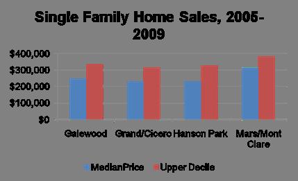
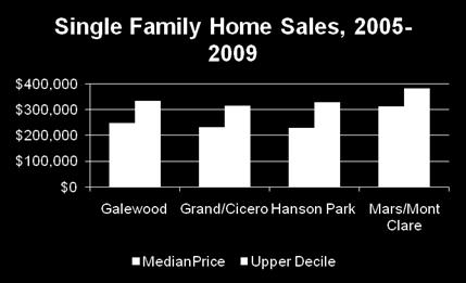
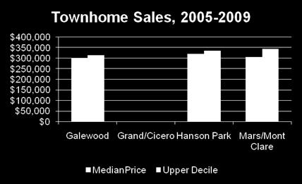
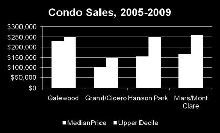
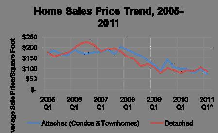
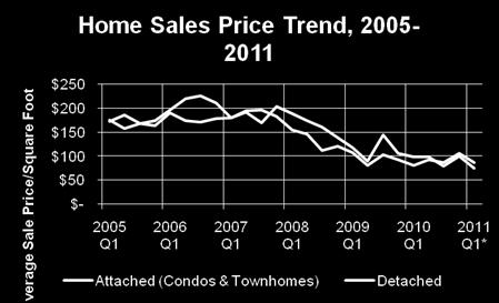
11 Residential Market Conditions 11
 Grand-Cicero 33,000 (2009) 33,000 (2009) AADT of Roadway (Year)")
12 Retail Corridor Conditions Montclare 12,500 (2006) Mars 13,600 (2006) 26,90 0 (2006) 24,100 (2009) Galewood Hanson Park 18,600 (2009) Grand-Cicero 33,000 (2009) 33,000 (2009) AADT of Roadway (Year) 12

13 Land Use & Transportation: Grand/Cicero Parking Supply Parking Utilization Weekday Boardings/ Alightings* Mode of Access (%)* Trains /Day 0 spaces N/A 72 on, 21 off Walk: 86/54 Dropped Off: 0/15 Drive Alone: 14/16 Transit: 0/8 Other: 0/8 13 in, 12 out Bus Routes CTA: 54, 65, 72, 73, 74 *Combined data for former Cragin and Hermosa Stations Strengths: Good transit, intact residential neighborhood, station visibility, major employers, development sites Weaknesses: auto-oriented uses, incompatible uses on Cicero, unattractive pedestrian environment, absence of commuter-oriented retail 13


14 Land Use & Transportation: Grand/Cicero Site Suitability Residential Infill development: single-family and two-flat Rehabilitation of existing singlefamily New multi-family and senior housing Mixed-use and Commercial Retail infill along arterial corridors Mixed-use near station Shared parking 14

15 Land Use & Transportation: Hanson Park Parking Supply Parking Utilization Weekday Boardings and Alightings Mode of Access (%) Trains /Day 31 spaces 90% 54 on, 51 off Walk: 22 Drive Alone: 56 Carpool: 7 Dropped Off: 4 Transit: 11 9 in, 7 out Bus Routes CTA: 65, 72, 74, 85 Strengths: transit service near station, major employers Weaknesses: limited south and east access to station, poor sidewalk conditions, pedestrian access limited, poor visibility, low population density, incompatible uses north of station, indirect bus connections 15


16 Land Use & Transportation: Hanson Park Site Suitability Regional Transportation Center Bus interchange Park and Ride Ancillary commercial Maintain employment center Improve connections to schools, parks and theater 16
 close")
17 Land Use & Transportation: Galewood Parking Supply 136 spaces Parking Utilization Weekday Boardings and Alightings 46% 265 on, 287 off Mode of Access Drive Alone: 51% Walk: 24% Dropped Off: 18% Transit: 4% Carpool: 3% Bike: 1% Trains /Day 21 in, 22 out Bus Routes CTA: 65, 72, 74, 86 Pace: 319 Strengths: good transit, major employers, station visible, residential (planned & existing) close to station, attractive station area Weaknesses: south pedestrian access limited, absence of commuter retail services, sidewalks/trackside pedestrian access limited, limited station visibility from Narragansett, Commercial Driver License facility adjacent to commuter station 17


18 Land Use & Transportation: Galewood Site Suitability Extension of urban neighborhood Convenient and attractive pedestrian access to station Small commercial uses and neighborhood vendor retail Residential Mixed income Mixed housing types Potential institutional / educational use Industrial retention south of station 18

19 Land Use & Transportation: Mars Parking Supply 63 spaces Parking Utilization Weekday Boardings and Alightings 52% 110 on, 102 off Mode of Access Walk: 53% Drive Alone: 25% Dropped Off: 14% Carpool: 8% Trains /Day 8 in, 8 out Bus Routes CTA: 65, 72, 74, 90 Pace: 319 Strengths: good western ped access, station area attractive, residential neighborhood nearby, major employers, station visibility Weaknesses: lack of bus connections/service, limited eastern ped access, absence of commuter retail services, no development sites, low population density within ¼ mile 19


20 Land Use & Transportation: Mars Site Suitability Infill: mixed-use or multifamily residential northeast of station Enhance pedestrian connections between station, major employers and other destinations 20

21 Land Use & Transportation: Mont Clare Parking Supply Parking Utilization Weekday Boardings and Alightings Mode of Access (%) 193 spaces 42% 361 on, 376 off Drive Alone: 41 Walk: 37 Dropped Off: 9 Carpool: 7 Bike: 3 Transit: 2 Trains /Day 21 in, 23 out Bus Routes CTA: 65, 72, 74, 90 Pace: 307, 319 Strengths: close to retail districts on Grand and Harlem, available development sites, multi-family housing near station, transit service nearby, ped path connects station to Rutherford Park and residential neighborhood to the east Weaknesses: indirect bus connections, western access cut off along Medill Ave, limited station visibility from major streets 21


22 Land Use & Transportation: Mont Clare Site Suitability Transit-friendly development near station Multifamily: condo or rental Ground-floor retail Structured parking Improved transit connections between station and Grand/Harlem 22

23 Opportunity Sites Submarket SF of Underutilized Building 1/4 Mile from Station 1/2 Mile from Station Grand/Cicero Submarket 164, ,881 Hanson Park Submarket 355, ,834 Galewood Submarket 574, ,900 Mars/Mont Clare Submarket 340, ,267 23
24 Questions? 24
25 Group Sessions Groups based on station areas Designate a Facilitator and a Reporter Roving Technical Support Goals Strengths Weaknesses Ideas for Development Ideas for Improvements 25
26 Findings: Grand/Cicero Station Parking Under-developed areas mentioned by alderman Station Visibility Safety Dead Zone between Kostner and Cicero South of Station on Cicero is run-down Limited service, particularly at night Good uses within a block of the station Walmart bus: investigate as means to get to and from station 26
27 Findings: Hanson Park Station Metra schedule: could it be reconsidered if major park-and-ride facility developed? 27
28 Findings: Galewood Station Station is new Ample parking Station area is clean Landscaping is neglected; trash a problem Gap in Metra service: no outbound trains leave downtown between 4:30 and 5:30 Difficult to access station from east Station ID: banner or other welcome Bike racks needed Coffee shop or other commuter-serving retail Businesses in immediate area snow removal is an issue Bike path More single-family desirable near station area Zip car site would be helpful in station parking 28
29 Findings: Mars Station Not much space for development Both hospital and Mars are good neighbors Difficult walk between Galewood and Montclare and Mars stations; issue due to limited train schedule at Mars Better signage off of Grand Ave Flag stops Parking permits in surrounding area Free parking vs. paid parking Trash in surrounding area Car storage lot: multi-family not a good use; institutional facility connected with Shriner s or senior center would be preferable (library) 29
30 Findings: Montclare Station Parking issue: free parking pass with monthly Metra pass; otherwise pay for occasional use Issue with informal parking along south side of tracks Crossing tracks Possibility of coffee/sandwich shop; there is one on Grand but somewhat run-down Residential development: there is enough in the area. Better station signage along Grand Empty retail near Grand/Harlem Library south of Grand near Sayre is gone; Jeep dealership on north side is also gone New restaurants or shops could replace those uses Integration between Metra, Pace and CTA to make it easier to do transfers 30
SUPPORTING TOD IN METRO CHICAGO
 www.rtachicago.org SUPPORTING TOD IN METRO CHICAGO Tuesdays at APA November 18, 2014 OVERVIEW OF RTA 2 11/18/2014 Tuesdays at APA: Supporting TOD in Metro Chicago RTA Region 8.5 million people 3,700 square
HIGH PROFILE RETAIL SPACE ON ICONIC GREEN BAY ROAD
 LEASE OVERVIEW AVAILABLE SF: LEASE RATE: YEAR BUILT: 2017 ZONING: MARKET: 2,000-6,200 SF $29.00 SF/Yr (NNN) Village Center Pedestrian Commercial West Chicago PROPERTY DESCRIPTION Incredible retail lease
Breakout Session. The Mobility Challenges of Our Growing & Sprawling Upstate
 Breakout Session The Mobility Challenges of Our Growing & Sprawling Upstate The Mobility Challenges of Our Growing & Sprawling Upstate Why is our suburban and sprawling development pattern a challenge
FOR SALE DEMPSTER STREET RETAIL CENTER Dempster St / Skokie, IL farabrokerage.com. Property Highlights FOR SALE: $895,000
 FOR SALE DEMPSTER STREET RETAIL CENTER Property Highlights Single-story, commercial building located on highlytrafficked Dempster Street 7,547 +/- SF building 11,800 +/- SF land site Currently divided
Existing CTA Blue Line: From Clinton Station to Forest Park Station IDOT Expansion Alternative: Forest Park Station to Mannheim Road
 Board 1: Blue Line Study Area History of the CTA Blue Line / I-290 system Blue Line / I-290 infrastructure is 55 years old First integrated transit / highway facility in the U.S. Project Study Area Existing
CTA Blue Line Study Area
 CTA Blue Line Study Area HISTORY OF THE CTA BLUE LINE / I-290 SYSTEM Blue Line / I-290 infrastructure is 55 years old First integrated transit / highway facility in the U.S. PROJECT STUDY AREA EXISTING
appendix 4: Parking Management Study, Phase II
 appendix 4: Parking Management Study, Phase II A4-1 A4-2 Eastlake Parking Management Study Final Phase 2 Report Future Parking Demand & Supply January 6, 2017 Submitted by Denver Corp Center III 7900 E.
Parking Management Element
 Parking Management Element The State Transportation Planning Rule, adopted in 1991, requires that the Metropolitan Planning Organization (MPO) area implement, through its member jurisdictions, a parking
Equitable transit-oriented development: Tools + Tactics
 Equitable transit-oriented development: Tools + Tactics Yonah Freemark February 18, 2016 Metropolitan Planning Council Chicagoland s growth over time 1950 Population density Fewer than 2,000 ppl/sq. mi.
2.0 Development Driveways. Movin Out June 2017
 Movin Out June 2017 1.0 Introduction The proposed Movin Out development is a mixed use development in the northeast quadrant of the intersection of West Broadway and Fayette Avenue in the City of Madison.
Green Line Long-Term Investments
 Enhancements Short-term improvements to keep Austin moving. Investments Long-term projects to support our future. Mobility Hubs MetroRapid MetroRail MetroExpress Connectors Circulators Project Connect
METRO Orange Line BRT American Boulevard Station Options
 METRO Orange Line BRT American Boulevard Station Options Bloomington City Council Work Session November 18, 2013 Christina Morrison BRT/Small Starts Project Office Coordinating Planning and Design AMERICAN
Garrett Hill Master Plan
 Garrett Hill Master Plan Visioning Workshop February 13, 2007 Campbell Thomas & Company Agenda Welcome Existing conditions summary Critical issues Visioning exercise Summary & next steps Critical Assets
West Broadway Transit Study. Community Advisory Committee September 17, 2015
 West Broadway Transit Study Community Advisory Committee September 17, 2015 Introductions Community Engagement Summer Outreach Fall Outreach Technical Analysis Process Update Alternatives Review Economic
Fresno County. Sustainable Communities Strategy (SCS) Public Workshop
 Public Workshop") Fresno County Sustainable Communities Strategy (SCS) Public Workshop Project Background Senate Bill 375 Regional Transportation Plan (RTP) Greenhouse gas emission reduction through integrated transportation
Fresno County Sustainable Communities Strategy (SCS) Public Workshop Project Background Senate Bill 375 Regional Transportation Plan (RTP) Greenhouse gas emission reduction through integrated transportation
residents of data near walking. related to bicycling and Safety According available. available. 2.2 Land adopted by
 2. Assessment of Current Conditions and Needs In order to prepare a plan to reach the vision desired by the residents of Texarkana, it is first necessary to ascertain the current situation. Since there
UTA Transportation Equity Study and Staff Analysis. Board Workshop January 6, 2018
 UTA Transportation Equity Study and Staff Analysis Board Workshop January 6, 2018 1 Executive Summary UTA ranks DART 6 th out of top 20 Transit Agencies in the country for ridership. UTA Study confirms
Yonge-Eglinton. Mobility Hub Profile. September 19, 2012 YONGE- EGLINTON
 September 19, 2012 PEEL YORK HALTON DURHAM HAMILTON TORONTO YONGE- EGLINTON MOBILITY HUBS: places of connectivity between regional and rapid transit services, where different modes of transportation come
Transit Hub Case Study: Owings Mills Metro Station. By: Kathleen Cary Rose, J. Luke Byrne and Catherine Buhler
 Executive Summary Transit Hub Case Study: Owings Mills Metro Station By: Kathleen Cary Rose, J. Luke Byrne and Catherine Buhler The purpose of the Transit Hub Case Study is to identify and evaluate the
APPENDIX VMT Evaluation
 APPENDIX 2.7-2 VMT Evaluation MEMORANDUM To: From: Mr. Jonathan Frankel New Urban West, Incorporated Chris Mendiara LLG, Engineers Date: May 19, 2017 LLG Ref: 3-16-2614 Subject: Villages VMT Evaluation
Appendix C. Parking Strategies
 Appendix C. Parking Strategies Bremerton Parking Study Introduction & Project Scope Community concerns regarding parking impacts in Downtown Bremerton and the surrounding residential areas have existed
Countywide Transit Corridors Functional Master Plan. Appendix 13 BRT Station Typology
 Countywide Transit Corridors Functional Master Plan Appendix 13 BRT Station Typology Tower 1, 10 th Floor 100 S. Charles Street Baltimore, MD 21201-2727 (410) 727-5050 Memorandum To: Larry Cole, M-NCPPC
LEED v4 Building Design and Construction Quiz #3 LT
 LEED v4 Building Design and Construction Quiz #3 LT 1. How are walking and bicycling distance measured? A. Straight-line radius from a main building entrance B. Straight-line radius from any building entrance
EUGENE-SPRINGFIELD, OREGON EAST WEST PILOT BRT LANE TRANSIT DISTRICT
 EUGENE-SPRINGFIELD, OREGON EAST WEST PILOT BRT LANE TRANSIT DISTRICT (BRIEF) Table of Contents EUGENE-SPRINGFIELD, OREGON (USA)... 1 COUNTY CONTEXT AND SYSTEM DESCRIPTION... 1 SYSTEM OVERVIEW... 1 PLANNING
Newmarket GO Station Mobility Hub Study. Open House #1 MAY 18, 2017
 Newmarket GO Station Mobility Hub Study Open House #1 Naren Garg Metrolinx Advisor, RER Project Planning Amy Shepherd IBI Group Associate, Manager, Planning INTRODUCTIONS - METROLINX Metrolinx is an agency
PROJECT SCHEDULE. Plan for Implementation. Explore and Analyze. Refine Ideas. Identify Common Ideas SPRING 2016 SUMMER 2016 FALL 2016
 VISION WORKSHOP MAY 25 th 2016 A COLLABORATION PROJECT SCHEDULE Explore and Analyze Identify Common Ideas Refine Ideas Plan for Implementation SPRING 2016 SUMMER 2016 FALL 2016 TODAY S AGENDA Explore and
US 81 Bypass of Chickasha Environmental Assessment Public Meeting
 US 81 Bypass of Chickasha Environmental Assessment Public Meeting March 14, 2013 Introductions ODOT FHWA SAIC Meeting Purpose Present need for bypass Provide responses to 10/04/11 public meeting comments
Otay Ranch Station 2020 MOBILITY SERVICES MAP REGIONAL MOBILITY HUB IMPLEMENTATION STRATEGY
 MAGDALENA REGIONAL MOBILITY HUB IMPLEMENTATION STRATEGY Otay Ranch Station Mobility hubs are transportation centers located in smart growth areas served by high frequency transit service. They provide
TRANSPORTATION REVIEW
 TRANSPORTATION REVIEW - PROPOSED MIX OF LAND USES IS CONSISTENT WITH THE CITY S UNDER THE GRANVILLE BRIDGE POLICIES THAT AIM TO MEET NEIGHBOURING RESIDENTS SHOPPING NEEDS AND REDUCE RELIANCE ON AUTOMOBILE
SANDAG 3D Visualization Howard Blackson 6:15. Sub Area A Coalition Massing/Phasing - Mike Labarre 6:30
 Agenda Grantville Master Plan Stakeholders Committee Meeting April 13, 2009 SANDAG 3D Visualization Howard Blackson 6:15 Sub Area A Coalition Massing/Phasing - Mike Labarre 6:30 Land Use and Street Alternatives
1 Downtown LRT Connector: Draft Concept
 Downtown LRT Connector: Draft Concept Plan November 2010 We re moving forward. Get involved. On June 21, 2010, City Council approved a street-level downtown LRT route, including a connector for the future
Brainstormed Solutions - Passenger
 1-1a Air / Exand: Expand capacity (runway lengths) at BG airport (LOW) find solution! 1-1b Air / fuel: Improve fuel availabilty and reduce cost (LOW) Sound Walls X X X Reduce scatter lighting - more focused
IMPROVEMENT CONCEPTS
 IMPROVEMENT CONCEPTS for the South Novato Transit Hub Study Prepared by: January 11, 2010 DKS Associates With Wilbur Smith Associates IMPROVEMENT CONCEPTS Chapter 1: Introduction 1. INTRODUCTION The strategic
Address Land Use Approximate GSF
 M E M O R A N D U M To: Kara Brewton, From: Nelson\Nygaard Date: March 26, 2014 Subject: Brookline Place Shared Parking Analysis- Final Memo This memorandum presents a comparative analysis of expected
San Rafael Civic Center Station Area Plan May 2012 DRAFT FOR PUBLIC REVIEW
 CHAPTER 4. PARKING Parking has been identified as a key concern among neighbors and employers in the area, both in terms of increased demand from potential new development and from SMART passengers that
Technology Evaluation Scorecard Suitability
 Technology Evaluation Scorecard Suitability Does the mode meet the MOE? Measure of Effectiveness Length of Typical Station Operating Technology Commute Spacing Speed Automated Guideway Bus Rapid Commuter
Denver Car Share Program 2017 Program Summary
 Denver Car Share Program 2017 Program Summary Prepared for: Prepared by: Project Manager: Malinda Reese, PE Apex Design Reference No. P170271, Task Order #3 January 2018 Table of Contents 1. Introduction...
Planning Commission Travis Parker, Planning Director DATE: March 7, 2018 SUBJECT: Lakewood Zoning Amendments - Parking
 MEMORANDUM TO: FROM: Planning Commission Travis Parker, Planning Director DATE: March 7, 2018 SUBJECT: Lakewood Zoning Amendments - Parking In August 2017, the Lakewood Development Dialogue process began
Executive Summary. Draft Environmental Impact Statement/Environmental Impact Report ES-1
 Executive Summary Introduction The Eastside Transit Corridor Phase 2 Project is a vital public transit infrastructure investment that would provide a transit connection to the existing Metro Gold Line
Mannheim/Higgins. Lee/Touhy. Municipal. Alternate 1), Village of Rosemont (Eastbound. Major Considerations:
, Village of Rosemont (Eastbound. Major Considerations:") Mannheim/Higgins Municipality: Municipality: City of Village Des Plaines of Skokie (Eastbound Alternate 1), Village of Rosemont (Eastbound Alternate Major 2 and Considerations: Westbound Alternate 1),
Mannheim/Higgins Municipality: Municipality: City of Village Des Plaines of Skokie (Eastbound Alternate 1), Village of Rosemont (Eastbound Alternate Major 2 and Considerations: Westbound Alternate 1),
Shuttle Bug: Linking Workers to Public Transportation in Northern Cook and Southern Lake Counties University of Illinois- Chicago Urban
 Shuttle Bug: Linking Workers to Public Transportation in Northern Cook and Southern Lake Counties University of Illinois- Chicago Urban Transportation Center- 2016 Seminar Series November 17,2016 About
Develop ground transportation improvements to make the Airport a multi-modal regional
 Project Overview TRANSPORTATION IMPROVEMENTS WHAT ARE THE PROJECT GOALS? Transportation transportation hub. Develop ground transportation improvements to make the Airport a multi-modal regional Land Use
Public Meeting. March 21, 2013 Mimosa Elementary School
 Public Meeting March 21, 2013 Mimosa Elementary School Today s Meeting Purpose 2 Where We Are The Process What We ve Heard and Findings Transit Technologies Station Types Break-out Session Where We Are
West Broadway Transit Study. Minnesota APA Conference Charles Carlson, Metro Transit Adele Hall, SRF Consulting September 24, 2015
 West Broadway Transit Study Minnesota APA Conference Charles Carlson, Metro Transit Adele Hall, SRF Consulting September 24, 2015 Study Context: Blue Line Planning 2 Study Context: Arterial BRT Study completed
RE: 67/71 Marquette Avenue Redevelopment Transportation Overview
 1223 Michael Street, Suite 100, Ottawa, Ontario K1J 7T2 Tel: 613.738.4160 Fax: 613.739.7105 www.delcan.com April 23, 2014 OUR REF: TO3157TOA00 BY EMAIL: mark.larose@urbanrisedevelopment.com Urban Rise
Station Evaluation. Durham-Orange Light Rail Transit Project Spring 2012
 Station Evaluation Durham-Orange Light Rail Transit Project Spring 2012 Key Ingredients for Station Development Platform Designs UNC Hospitals Station The UNC Hospitals Station Option D would be the westerly
Attachment D Environmental Justice and Outreach
 Attachment D Environmental Justice and Outreach ATTACHMENT D Environmental Justice and Outreach Indicate whether the project will have disproportionately high and adverse impacts on minority or low income
Pace Bus Depot Location Analysis
 Pace Bus Depot Location Analysis Key Notes 1. Options refer to conceptual sketches prepared by Kimley Horn. 2. The depot is assumed to accommodate Pace routes as they currently exist: 17 routes on the
Image from:
 Mercer County 1. Background Information Mercer County was carved out of surrounding counties in 1838 and has a history dating back to the Revolutionary War. It has 13 municipalities covering 226 square
Chicago Transit Authority Service Standards and Policies
 Chicago Transit Authority Service Standards and Policies Overview and Objectives The Chicago Transit Authority (CTA) has revised its Service Standards and Policies in accordance with Federal Transit Administration
1.0 INTRODUCTION Organization of this Report Study Area EXISTING CONDITIONS CTA Rail Forest Park Branch...
 Table of Contents 1.0 INTRODUCTION... 4 1.1 Organization of this Report... 4 1.2 Study Area... 4 2.0 EXISTING CONDITIONS... 5 2.1 CTA Rail Forest Park Branch... 5 3.0 SERVICE PATTERNS... 6 3.1 Car Requirements...
The Courtyard Building - 2nd & 3rd Floor For Sale
 Executive Summary PROPERTY SUMMARY Sale Price: $2,011,000 Subject Property SqFt: 36,575 SF Price Per SF: $54.98 Parking Spaces: 226 Building Renovated: 2016 Zoning: Sea Pines Commercial Market: Hilton
CORE AREA SPECIFIC PLAN
 only four (A, B, D, and F) extend past Eighth Street to the north, and only Richards Boulevard leaves the Core Area to the south. This street pattern, compounded by the fact that Richards Boulevard is
August 2, 2010 Public Meeting
 Public Meeting LYMMO Expansion Alternatives Analysis Study Purpose of study is to provide a fresh look at potential LYMMO expansion, following Federal Transit Administration (FTA) Alternatives Analysis
The TDM Plan for Fort Washington Office Park NOVEMBER 1 6, 2017 FORT WASHINGTON OFFICE PARK STAKEHOLDERS
 The TDM Plan for Fort Washington Office Park NOVEMBER 1 6, 2017 FORT WASHINGTON OFFICE PARK STAKEHOLDERS What is Transportation Demand Management (TDM)? Sources: Philly.com, Montgomery County, GVF Location
Whither the Dashing Commuter?
 Whither the Dashing Commuter? The MTA in a Changing Region William Wheeler Director of Special Project Development and Planning Travel in the New York Region has changed from the days of the 9 to 5 commute
Troost Corridor Transit Study
 Troost Corridor Transit Study May 23, 2007 Kansas City Area Transportation Authority Agenda Welcome Troost Corridor Planning Study Public participation What is MAX? Survey of Troost Riders Proposed Transit
2 EXISTING ROUTE STRUCTURE AND SERVICE LEVELS
 2 EXISTING ROUTE STRUCTURE AND SERVICE LEVELS In the Study Area, as in most of the Metro Transit network, there are two distinct route structures. The base service structure operates all day and the peak
NEW URBAN RETAIL 1100 ELLESMERE ROAD - SCARBOROUGH. NOW LEASING Brokers Protected
 NEW URBAN RETAIL 1100 ELLESMERE ROAD - SCARBOROUGH NOW LEASING Brokers Protected Concept rendering, rental rates and site data subject to change without notice. E. & O.E January 2016 HIGHLIGHTS Excellent
TRAIN, BUS & TRANSIT
 TRAIN, BUS & TRANSIT Input Metra 1 Metra does not want to add parking because of space; maxed out on number of cars per train. Developments on Rt. 59 will affect. 2 Should do studies regarding what the
RETAIL LEASING OPPORTUNITY
 RETAIL LEASING OPPORTUNITY ROUTE 7 & ROUTE 123 TYSONS CORNER, VIRGINIA IMMEDIATE DELIVERY For more information, please contact: Michael Zacharia Lance L.J. Marine Senior Vice President Associate michael.zacharia@cbre.com
The Screening and Selection of Regionally Significant Projects
 The Screening and Selection of Regionally Significant Projects UTC 2018 Seminar Series March 15, 2018 Claire Bozic Martin Menninger ON TO 2050 CMAP is the Region s MPO, seven county region Land use and
Utilizing GIS Models in Prioritizing and Selecting Transportation Projects
 Utilizing GIS Models in Prioritizing and Selecting Transportation Projects GIS-T Conference Raleigh, NC April 7, 2016 Tyler Meyer, AICP Tram Truong, GISP Outline Case Studies: 1. MPO project selection
ELKO JUNCTION SOUTH EXCLUSIVELY MARKETED BY STRATA REALTY GROUP DEVELOPED & MANAGED BY MERIDIAN PACIFIC
 EXCLUSIVELY MARKETED BY STRATA REALTY GROUP DEVELOPED & MANAGED BY MERIDIAN PACIFIC ELKO A PREMIER RETAIL DEVELOPMENT IN THE HEART OF GOLD COUNTRY. Elko Junction will continue its standard of retail excellence
Harlem Avenue between 63 rd and 65 th
 Harlem Avenue between 63 rd and 65 th Public Meeting #2 March 13, 2018 Summit Park District Welcome to the second Public Meeting for the preliminary engineering and environmental studies of Illinois 43
Public Meeting. City of Chicago Department of Transportation & Department of Housing and Economic Development
 Public Meeting City of Chicago Department of Transportation & Department of Housing and Economic Development Funded by Regional Transportation Authority September 12, 2011 In partnership with Presentation
Jeff s House. Downtown Charlottesville. PEC Office
 Jeff s House Downtown Charlottesville PEC Office Year 2000 US Census Data Employed persons over 16 Percentage of Employed Persons Locality Avg Commute (in minutes) Drove Public Transit Walk/Bike Other
Citizens Committee for Facilities
 Citizens Committee for Facilities AGENDA Thursday, December 11, 2014 City Council Chambers 305 3 rd Avenue East -Twin Falls, Idaho 11:30 A.M. AGENDA ITEMS Purpose By 1. Discussion and possible action on
CHICAGO TRANSIT AUTHORITY
 CHICAGO TRANSIT AUTHORITY Blue Line Extension to Schaumburg RTA Northwest Corridor Phase II Alternatives Analysis May 8, 2003 Project Overview In June 2002 RTA requested that CTA, Pace, Metra and ISTHA,
Central Loop Bus Rapid Transit
 Central Loop Bus Rapid Transit Transportation Goals of the Chicago Central Area ACTION Plan, page 2-6 Central Area Plan Improve Transit in Central Area Improve Pedestrian Environment Manage Traffic Circulation
Location Concept Plan Amendment Recommendation Approved 2011 Concept Plan
 Valley Line West LRT Concept Plan Recommended Amendments Lewis Farms LRT Terminus Site Location Concept Plan Amendment Recommendation Approved 2011 Concept Plan Lewis Farms LRT terminus site, 87 Avenue/West
Subarea Study. Manning Avenue (CSAH 15) Corridor Management and Safety Improvement Project. Final Version 1. Washington County.
 Corridor Management and Safety Improvement Project. Final Version 1. Washington County.") Subarea Study Manning Avenue (CSAH 15) Corridor Management and Safety Improvement Project Final Version 1 Washington County June 12, 214 SRF No. 138141 Table of Contents Introduction... 1 Forecast Methodology
Subarea Study Manning Avenue (CSAH 15) Corridor Management and Safety Improvement Project Final Version 1 Washington County June 12, 214 SRF No. 138141 Table of Contents Introduction... 1 Forecast Methodology
Appendix A. Community Workshop Results PUBLIC REVIEW DRAFT
 Appendix A Community Workshop Results This Page Left Blank Intentionally Comprehensive Planning Community Workshop Summary July 30, 2012 The City of Becker invited the Community to participate in a Comprehensive
We Want Your Input! Review the design alternatives and tell us what s important to you in the design of these areas of the approved BRT Network:
 We Want Your Input! Review the design alternatives and tell us what s important to you in the design of these areas of the approved BRT Network: Richmond North of Oxford Street Richmond Row Dundas Street
Dallas Area Rapid Transit (DART) Cotton Belt Regional Rail Project
 Cotton Belt Regional Rail Project") Dallas Area Rapid Transit (DART) Cotton Belt Regional Rail Project Kick-Off Meeting - Richardson and Plano Community Stakeholders Richardson Civic Center March 28, 2019 0 How to Stay Informed Visit www.dart.org/cottonbelt
Dallas Area Rapid Transit (DART) Cotton Belt Regional Rail Project Kick-Off Meeting - Richardson and Plano Community Stakeholders Richardson Civic Center March 28, 2019 0 How to Stay Informed Visit www.dart.org/cottonbelt
Spatial planning and sustainable urban transport systems
 Jean-Christophe Goudouneix Rita Magris Laura Richter Nicolae Serban Stef Tomesen George Yates Erasmus Intensive Programme 2013 Oradea Group 4 Spatial planning and sustainable urban transport systems Developing
car2go Toronto Proposal for on-street parking pilot project
 car2go Toronto Proposal for on-street parking pilot project Public Works & Infrastructure Committee June 18, 2014 Car2go Overview car2go is currently operating in 14 cities in North America, 12 cities
Navigating in Different Rivers
 Navigating in Different Rivers Suburban TOD Julie Jones, Planning Manager, City of Fridley Julie Farnham, Senior Planner, City of Bloomington Kersten Elverum, Director of Planning & Development, City of
71, 75 MONTREAL STREET PARKING STUDY
 71, 75 MONTREAL STREET PARKING STUDY Prepared for: Prepared by: Urban Core Ventures Boulevard Transportation, a division of Watt Consulting Group Our File: 1975 Date: June 20 2016 CONTENTS 1.0 INTRODUCTION...
17.8 acres site 4.6 acres in floodplain & wetlands 3.5 acres of surface parking 9 acres of open space
 Peter Allen Associates, Inc. Nederveld, Inc. Ann Arbor/Grand Rapids Riverfront Village LLC 17.8 acres site 4.6 acres in floodplain & wetlands 3.5 acres of surface parking 9 acres of open space 17,000 Hospital
Orange Line Transit Neighborhood Planning Effort GOALS. mobility
 Transit Neighborhood ning Effort GOALS mobility walkability mix of uses public space jobs & housing ort h We ntw Gl t ds Transit Neighborhood ning Effort or f nd ks oa en CORRIDOR VISION a Bl Br vd Tampa
Planned Development Application 1450 Sherman Avenue Evanston, IL TRAFFIC CIRCULATION IMPACT STUDY
 Planned Development Application 1450 Sherman Avenue Evanston, IL 60201 14 TRAFFIC CIRCULATION IMPACT STUDY Traffic Impact Study 1454 Sherman Mixed-Use Development Evanston, Illinois Prepared for Prepared
Stoughton Center Parking
 Stoughton Center Parking Existing Conditions and Observations October 4, 2017 Agenda Introduction Metropolitan Area Planning Council Project Team Parking Studies Background Scope of Work Study Area Survey
Boalsburg Tech Park Build-to-Suit. 176 Technology Drive, Boalsburg, PA 16827
 Property Details New Build-to-Suit opportunities in the Boalsburg Technology Park. Partnership and investment opportunities will be considered. The existing park will accommodate various building types
Public Meeting Thursday, Dec. 15, 2011 Chicago Union Station Union Gallery Room. Welcome
 Public Meeting Thursday, Dec. 15, 2011 Chicago Union Station Union Gallery Room Welcome 1 Union Station History The last of Chicago s historic stations; now owned by Amtrak Designed primarily to serve
Retail Site Analysis. Filling Station Car Wash FM 1092 Missouri City, Texas 77459
 Retail Site Analysis Filling Station Car Wash 1255 FM 1092 Missouri City, Texas 77459 June 29, 2018 Project Summary It has been proposed to develop a new generation, express conveyor tunnel car wash with
Space holder to add drone footage/movie
 RALEIGH OVERVIEW Space holder to add drone footage/movie 2 Raleigh, North Carolina 3 Raleigh is centrally located on the eastern seaboard approximately midway between Maine and Miami, Florida 4 Capturing
vision42
 vision42 www.vision42.org vision42 auto-free light rail boulevard for 42nd Street Roxanne Warren, AIA, Chair George Haikalis, ASCE, Co-Chair Institute for Rational Urban Mobility,Inc. www.vision42.org
D. Motor vehicle parking, bicycle parking, and loading areas shall be separated from one another.
 1015 PARKING AND LOADING 1015.01 GENERAL STANDARDS A. Inside the Portland Metropolitan Urban Growth Boundary (UGB), parking, loading, and maneuvering areas shall be hard-surfaced, unless a permeable surface
Rocky Mount. Transportation Plan. Transportation Planning Division. Virginia Department of Transportation
 2020 Transportation Plan Developed by the Transportation Planning Division of the Virginia Department of Transportation in cooperation with the U.S. Department of Transportation, Federal Highway Administration
CTA Blue Line Study Area
 1 CTA Blue Line Study Area HISTORY OF THE CTA BLUE LINE / I-290 SYSTEM Blue Line / I-290 infrastructure is 55 years old First integrated transit / highway facility in the U.S. PROJECT STUDY AREA EXISTING
Public Meeting. June 15, :30 7:30 p.m.
 Public Meeting June 15, 2017 5:30 7:30 p.m. Welcome 2015 Naval Station Norfolk Transit Extension Study 2015 Naval Station Norfolk Transit Extension Study 2017 Norfolk Westside Transit Study HRT and the
OFF-STREET PARKING REFORM IN MINNEAPOLIS AND ST. PAUL
 OFF-STREET PARKING REFORM IN MINNEAPOLIS AND ST. PAUL MINNESOTA APA October 1, 2014 Minneapolis Zoning Codes 1924 City s first zoning code 1963 City s second zoning code, which included the city s first
Appendix C: GAPS ANALYSIS
 Appendix C: GAPS ANALYSIS Appendix C Gaps Analysis While portions of Salt Lake City are well served by transit, some portions of the city experience a mismatch in the existing transit supply and current
Click to edit Master title style
 Nelson/Nygaard Consulting Associates SERVICE IMPROVEMENT STRATEGIES September 22, 2015 1 PROJECT OVERVIEW & WORK TO DATE 1. Extensive stakeholder involvement Throughout 2. System and market assessment
Santa Rosa Downtown Progressive Parking Strategy & Railroad Square Parking Plan. Presented by: Lauren Mattern
 Santa Rosa Downtown Progressive Parking Strategy & Railroad Square Parking Plan Presented by: Lauren Mattern October 2016 Today s Agenda Project Overview Current System Highlights Community Outreach Feedback
Light rail, Is New Zealand Ready for Light Rail? What is Needed in Terms of Patronage, Density and Urban Form.
 Light rail, Is New Zealand Ready for Light Rail? What is Needed in Terms of Patronage, Density and Urban Form. THE PROBLEM LIGHT RAIL THE SOLUTION? INTRODUCTION Light rail transit (LRT) provides the opportunity
REDEFINING OPPORTUNITY A Strategic Connection to One of the World s Best Airports
 REDEFINING OPPORTUNITY A Strategic Connection to One of the World s Best Airports GLOBALLY CENTERED REAL ESTATE With approximately 16,000 of commercial development land, DEN Real Estate s Strategic Development
7 Mass Transit. 7.1 Existing Conditions. 7.2 Transit
 7 Mass Transit 7.1 Existing Conditions Rural public transportation presents a unique challenge. Long trips and low population densities mean that it is a challenge to get sufficient ridership to support
MPO Transit Study. Transit Concept for 2050 November 5, Transit Technologies
 Hillsborough County MPO Transit Study Transit Concept for 2050 November 5, 2007 Transit Technologies 1 Technologies Considered Bus Light Rail Commuter Rail Bus Standard or articulated high-capacity vehicles