Access Management: An R-CUT Above the Rest
|
|
|
- Bryan Garry Terry
- 6 years ago
- Views:
Transcription
1 Access Management: An R-CUT Above the Rest Presented by Cristine Gowland LADOTD District 62


2 What is an R-CUT? Restricted Crossing U-Turn Non-traditional intersection design: Side street traffic right only U-turn to complete left turn or thru movement Signalized or Un-signalized Benefits: Improved safety Increased efficiency AKA a J-Turn or Superstreet

3 Safety: Conflict Point Reduction CONFLICT TYPE CROSSING CONFLICTS MERGING CONFLICTS DIVERGING CONFLICTS TOTAL CONFLICT POINTS TRADITIONAL INTERSECTION R-CUT


4 J-Turn = U-Turn?

5 District 62 R-CUT Examples H : LA 21 at Zinnia /Greenbriar H : US 190 from LA 22 to Lonesome H : LA 21 Bootlegger to 11th H : US 190 Superstreet

6 LA 21 at Zinnia/Greenbriar Urban 4-lane Divided 2015 AADT: 22,238 45MPH Posted Speed Limit Signalized Corridor Multiple Projects & Permits Zinnia/Greenbriar Issues Crashes Delays Complaints Unwarranted Signal Requests Lack of Policy

7 Aerial View of LA 21 Area

8 LA 21 at Zinnia/Greenbriar (2007) Before Widening Project (H )


9 LA 21 at Zinnia/Greenbriar (2011) After Widening Project (H )
10 LA 21 at Zinnia/Greenbriar R-CUT Project Info State Project H completed in August 2012 Constructed channelized median through Zinnia/Greenbriar U-turns north and south with bump-outs designed for school buses and fire trucks No public meetings were conducted DA and DTOE held meetings with local HOA and elected officials


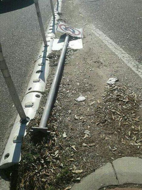
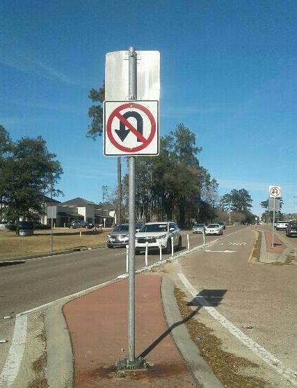
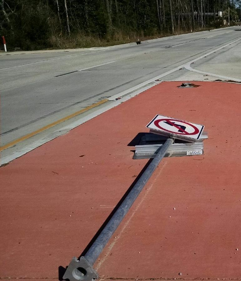
11 LA 21 at Zinnia/Greenbriar After R-CUT State Project H Center Median Control with Curb-and-Paddles No U-Turn Signage


12 LA 21 at Zinnia/Greenbriar Un-signalized R-CUT Intersection Greenbriar Blvd LA 21 Zinnia Dr

13 Drone Footage LA Zinnia/Greenbriar
14 Before & After Crash History LA 21 at Zinnia/Greenbriar Year Right Angle Left Turn Rear End Run off Road Right Turn Sideswipe Other Non- Collision Injury TOTAL * *Note: 2 right angle crashes were coded in 2015, but one was a right turn crash and one was a left turn crash.


15 EDSM IV Project-specific Guidance Recommendations Vary by Roadway Configuration Spacing of Median Openings Waivers to EDSM
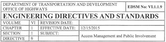
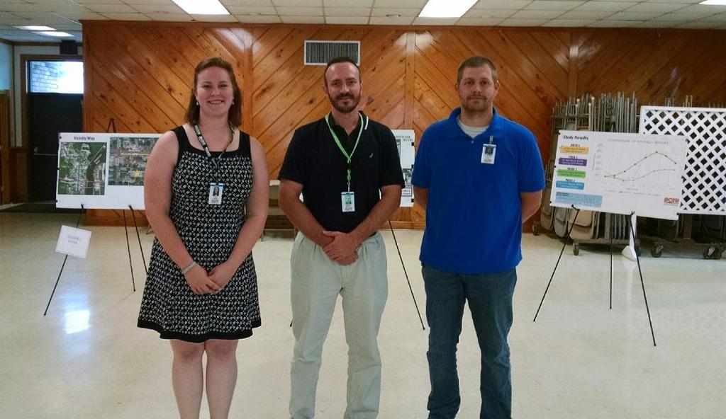
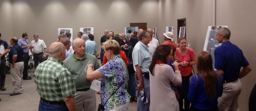
16 Our Experiences... Public Involvement
17 Our Experiences... Public Outreach
18


19 Our Experiences... Convenience vs Safety Public views this as driving out of their way Public may favor convenience over safety Misconceptions about delays

20
21 Our Experiences... Traffic Studies Count What are the existing problems in the study area? Will my design work? How well will my design work? How long will my design work? What alternatives will work? Which alternative will work best and is cost-efficient? What is the best form of traffic control? Do I have safety issues to address? How do I phase construction? How can I phase large-scale improvements?

22 Our Experiences... Effects on Local Development Shopping Center Permitted: 9/2016 Gas Station & Shopping Center Permit In Progress Shopping Center & Restaurant (Phase 1) Permitted: 10/2017 Shopping Center & Restaurant (Full Build) Permit In Progress Starbucks & Dental Clinic Permitted: 8/2016
23 Our Experiences... Bump-out Design H Passenger Vehicle Dimensions = 19 x 7 ~34 passenger vehicles can fit in the bump-out *Designed for a WB-67
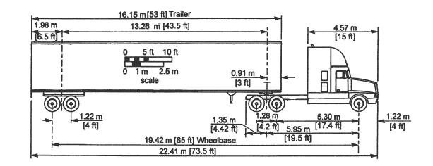
24 Our Experiences... Bump-out Design
25


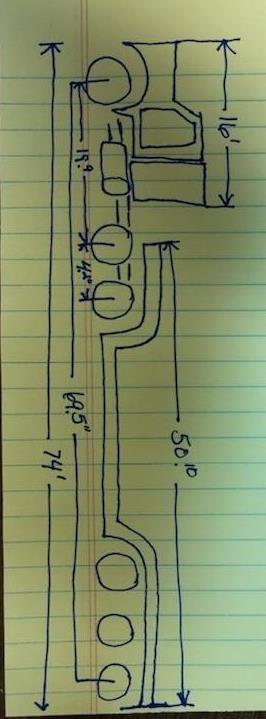
26 Our Experiences... Bump-out Design Lowboy vs WB-67 Modify Center Curb to Accommodate Larger Design Vehicles 5 Wide Median


27 Our Experiences... Bump-outs Parking in Bump-outs Educate Law Enforcement & Public Location of Bump-outs
 US 190 @ Lonesome Road (Tee Intersection) Mandeville, St Tammany Parish *View from Lonesome Road (side")
28 Our Experiences... Curbing (Older Project) US Lonesome Road (Tee Intersection) Mandeville, St Tammany Parish *View from Lonesome Road (side street) No Left Turn/One Way Signage Channelized Curb on Mainline Gap In Curbing Tip of Median Yellow Channelized Striping
")

29 Our Experiences... Curbing (Older Project) US Lonesome Road Mandeville, St Tammany Parish *Aerial View
 LA 21 @ Cherokee Rose/Innwoods Covington, St Tammany Parish *View from Inwoods (side street)")
30 Our Experiences... Curbing (Recent Project) LA Cherokee Rose/Innwoods Covington, St Tammany Parish *View from Inwoods (side street) Center Back-to-Back Curb No Gap In Curbing Yield Line Back-to-Back Curb (between yellow lines) One Way Signage
 LA 21 @ Cherokee Rose/Innwoods Covington, St Tammany Parish Yield Lines Back-to-Back Curb (between")
31 Our Experiences... Curbing (Recent Project) LA Cherokee Rose/Innwoods Covington, St Tammany Parish Yield Lines Back-to-Back Curb (between yellow lines) Back-to-Back Curb (between yellow lines) Center Back-to-Back Curb (between white lines) *Aerial View
32
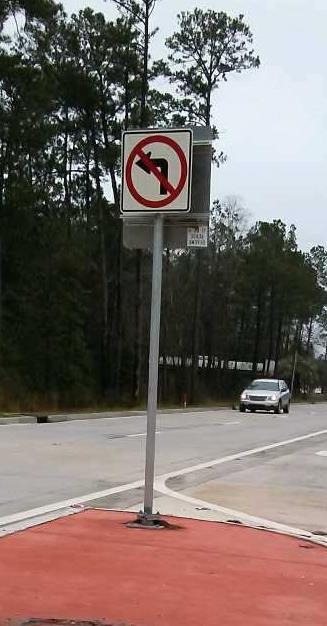
33 Our Experiences... Maintenance Debris Collects Signs Have to be Reinstalled

34 Our Experiences... Signalization Two existing, partially signalized R-CUTS Traditional signal warrants may not apply Signalized based on presence of: Limited sight distance Dual movements Significant delays Excessive queues Safety concerns Other issues
35 US 190 Superstreet Background Information Covington, St Tammany Parish 61,490 ADT in mph, six-lane, divided urban arterial from I-12 to US 190 Business (Median width ~ 65 ) Corridor can be divided into two sections: I-12 to the Abita River Bridge (~ 2 miles) 7 traditional signals 6 U-Turns with yield control Abita River Bridge to US 190 Business (~ 1 mile) 3 full-access, two-way stop controlled intersections (80-90 wide) 3 U-Turns with yield control. Bordered by a signalized corridor to the north & I-12 to the south
36 Project Update: US 190 Superstreet (H ) Study completed in 2010 Project Let in September 2017 Original project modified to accommodate new development Construction includes: Installation of new curbing Relocation of intersections and U-Turns Installation of 15 new signals Upgrade controllers and detection for 2 existing signals Installation of a fiber interconnect with switches for all 17 signals All signals on this section will be 2 phases only

37
38 Lessons Learned Public involvement is key to a successful job Efficiency versus safety Traffic studies Impacts to commercial development Design of bump-outs Limiting turning movements with curb/signage Maintenance issues Signalization
39 Questions
Evaluation Considerations and Geometric Nuances of Reduced Conflict U-Turn Intersections (RCUTs)
") Evaluation Considerations and Geometric Nuances of Reduced Conflict U-Turn Intersections (RCUTs) 26 th Annual Transportation Research Conference Saint Paul RiverCentre May 20, 2015 Presentation Outline
Evaluation Considerations and Geometric Nuances of Reduced Conflict U-Turn Intersections (RCUTs) 26 th Annual Transportation Research Conference Saint Paul RiverCentre May 20, 2015 Presentation Outline
Safety Evaluation of Restricted Crossing U-Turn (RCUT or J-Turn) Projects in Louisiana
 Projects in Louisiana") Safety Evaluation of Restricted Crossing U-Turn (RCUT or J-Turn) Projects in Louisiana Xiaoduan Sun University of Louisiana at Lafayette 2018 Louisiana Transportation Engineering Conference Outline Project
Safety Evaluation of Restricted Crossing U-Turn (RCUT or J-Turn) Projects in Louisiana Xiaoduan Sun University of Louisiana at Lafayette 2018 Louisiana Transportation Engineering Conference Outline Project
Traffic Engineering Study
 Traffic Engineering Study Bellaire Boulevard Prepared For: International Management District Technical Services, Inc. Texas Registered Engineering Firm F-3580 November 2009 Executive Summary has been requested
INTERSECTION CONTROL EVALUATION
 INTERSECTION CONTROL EVALUATION Trunk Highway 22 and CSAH 21 (E Hill Street/Shanaska Creek Road) Kasota, Le Sueur County, Minnesota November 2018 Trunk Highway 22 and Le Sueur CSAH 21 (E Hill Street/Shanaska
Open House. Highway212. Meetings. Corridor Access Management, Safety & Phasing Plan. 5:30 to 6:30 p.m. - Southwest Corridor Transportation Coalition
 Welcome Meetings 5:30 to 6:30 p.m. - Southwest Corridor Transportation Coalition 6:30 to 8:00 p.m. - Open House Why is Highway 212 Project Important? Important Arterial Route Local Support Highway 212
Safety Assessment. Intersection of Route 29 (Seminole Trail) and Ashwood Blvd (Route 1670). Albemarle County
 and Ashwood Blvd (Route 1670). Albemarle County") Safety Assessment for Intersection of Route 29 (Seminole Trail) and Ashwood Blvd (Route 1670). Albemarle County Prepared by: VIRGINIA DEPARTMENT OF TRANSPORTATION Northwestern Regional Operations - Traffic
Safety Assessment for Intersection of Route 29 (Seminole Trail) and Ashwood Blvd (Route 1670). Albemarle County Prepared by: VIRGINIA DEPARTMENT OF TRANSPORTATION Northwestern Regional Operations - Traffic
LaDOTD s s New Traffic Control Details
 LaDOTD s s New Traffic Control Details Louisiana Pavement Conference Baton Rouge, Louisiana October 7, 2004 Charles Adams, P.E., PTOE Objectives Traffic Background Information What Drove the Department
DELINEATOR REFERENCE POINT 200' TYPICAL SPACING (YELLOW DELINEATORS) END OF MERGE LANE TAPER DELINEATOR REFERENCE POINT
 END OF MERGE LANE TAPER DELINEATOR REFERENCE POINT") 200' TYP. 0' < EACH SIDE BOTH ROADWAYS END OF MERGE LANE TAPER TYPICAL FOR ALL 2-LANE MERGES EXCEPT WHERE THERE IS A MERGE FROM THE RIGHT AND NO OFFSET IN THE THROUGH LANES END OF MERGE LANE TAPER 200'
200' TYP. 0' < EACH SIDE BOTH ROADWAYS END OF MERGE LANE TAPER TYPICAL FOR ALL 2-LANE MERGES EXCEPT WHERE THERE IS A MERGE FROM THE RIGHT AND NO OFFSET IN THE THROUGH LANES END OF MERGE LANE TAPER 200'
RAILROAD PREEMPTION FORMS. Mark Johnson, P.E.
 RAILROAD PREEMPTION FORMS Mark Johnson, P.E. October 12, 2016 The Basic Problem Vehicles stop on tracks Need to interconnect traffic signal with railroad cabinet 2 Preemption Process: ROW Transfer 1 st
Traffic Impact Study Speedway Gas Station Redevelopment
 Traffic Impact Study Speedway Gas Station Redevelopment Warrenville, Illinois Prepared For: Prepared By: April 11, 2018 Table of Contents 1. Introduction... 1 2. Existing Conditions... 4 Site Location...
Louisiana s s Work Zone Task Force Work Zone Improvements
 Louisiana s s Work Zone Task Force Work Zone Improvements Louisiana Asphalt Technology Conference Shreveport, Louisiana February 24, 2005 Charles Adams, P.E., PTOE Why Improve Work Zones? Number of Work
To: File From: Adrian Soo, P. Eng. Markham, ON File: Date: August 18, 2015
 Memo To: From: Adrian Soo, P. Eng. Markham, ON : 165620021 Date: Reference: E.C. Row Expressway, Dominion Boulevard Interchange, Dougall Avenue Interchange, and Howard 1. Review of Interchange Geometry
85th. HB 87 vs 85 Percentile Speed
 House Bill 87 25 mph Speed Voluntary Technical Workshop 85th HB 87 vs 85 Percentile Speed Cissy Sylo, P.E. Director of Engineering Services City of Frisco January 20, 2006 Background Prima Facie Speed
Highway 23 New London Access & Safety Assessment. Public Open House #2 October 3, :00 to 7:00 PM
 Public Open House #2 October 3, 2017 5:00 to 7:00 PM Highway 9 OVERVIEW OF ASSESSMENT Assessment Limits Highway 23 from County Road 40 to North Shore Dr Purpose: Identify opportunities to reduce serious
Technical Feasibility Report
 Prepared For: Bow Concord I-93 Improvements Project Bow and Concord, NH Prepared By: 53 Regional Drive Concord, NH 03301 NHDOT Project # 13742 Federal Project #T-A000(018) September 2018 TABLE OF CONTENTS
Local Road Safety Program. Marie B. Walsh, Director Louisiana LTAP January 10, 2011 Louisiana Transportation Conference
 Local Road Safety Program Marie B. Walsh, Director Louisiana LTAP January 10, 2011 Louisiana Transportation Conference Local Road Safety Program Addresses the ALL public road inclusion of SAFETEA-LU Primary
Rolling Road (Route 638) Widening Project
 Widening Project") Rolling Road (Route 638) Widening Project From: 0.369 Mile North of Fairfax County Parkway (Route 286) To: Old Keene Mill Road (Route 644) State Project No. 0638-029-156, P104, R204, C504; UPC 5559 Public
Rolling Road (Route 638) Widening Project From: 0.369 Mile North of Fairfax County Parkway (Route 286) To: Old Keene Mill Road (Route 644) State Project No. 0638-029-156, P104, R204, C504; UPC 5559 Public
Figure 1 Map of intersection of SR 44 (Ravenna Rd) and Butternut Rd
 and Butternut Rd") Abbreviated Study District: 12 County: Geauga Route: SR 44 Section: 1.58 GEA 44 1.58 213 HSP # 47 (Rural Intersection) Prepared April 23, 215 By Bryan Emery Existing Conditions This study contains the
Abbreviated Study District: 12 County: Geauga Route: SR 44 Section: 1.58 GEA 44 1.58 213 HSP # 47 (Rural Intersection) Prepared April 23, 215 By Bryan Emery Existing Conditions This study contains the
IMPROVEMENT CONCEPTS
 IMPROVEMENT CONCEPTS for the South Novato Transit Hub Study Prepared by: January 11, 2010 DKS Associates With Wilbur Smith Associates IMPROVEMENT CONCEPTS Chapter 1: Introduction 1. INTRODUCTION The strategic
Alberta Infrastructure HIGHWAY GEOMETRIC DESIGN GUIDE AUGUST 1999
 &+$37(5Ã)Ã Alberta Infrastructure HIGHWAY GEOMETRIC DESIGN GUIDE AUGUST 1999 &+$37(5) 52$'6,'()$&,/,7,(6 7$%/(2)&217(176 Section Subject Page Number Page Date F.1 VEHICLE INSPECTION STATIONS... F-3 April
TRAFFIC IMPACT STUDY. USD #497 Warehouse and Bus Site
 TRAFFIC IMPACT STUDY for USD #497 Warehouse and Bus Site Prepared by: Jason Hoskinson, PE, PTOE BG Project No. 16-12L July 8, 216 145 Wakarusa Drive Lawrence, Kansas 6649 T: 785.749.4474 F: 785.749.734
Appendix J Traffic Impact Study
 MRI May 2012 Appendix J Traffic Impact Study Level 2 Traffic Assessment Limited Impact Review Appendix J [This page was left blank intentionally.] www.sgm-inc.com Figure 1. Site Driveway and Trail Crossing
Restricted Crossing U-Turn (RCUT) Intersection Concept, Case Studies, and Design Guide ITE Midwest Annual Meeting June 30, 2015 Branson, MO
 Intersection Concept, Case Studies, and Design Guide ITE Midwest Annual Meeting June 30, 2015 Branson, MO") Restricted Crossing U-Turn (RCUT) Intersection Concept, Case Studies, and Design Guide 2015 ITE Midwest Annual Meeting June 30, 2015 Branson, MO Wei Zhang, Ph.D., P.E. Program Manager, Intersection Safety
Restricted Crossing U-Turn (RCUT) Intersection Concept, Case Studies, and Design Guide 2015 ITE Midwest Annual Meeting June 30, 2015 Branson, MO Wei Zhang, Ph.D., P.E. Program Manager, Intersection Safety
CHANGE LIST for MDOT Traffic and Safety Geometric Design Guides. May 23, 2017: The following update was made to the web site.
 CHANGE LIST for MDOT Traffic and Safety Geometric Design Guides Note: Located at https://mdotjboss.state.mi.us/tssd/tssdhome.htm May 23, 2017: The following update was made to the web site. GEO-650-D Flares
LAWRENCE TRANSIT CENTER LOCATION ANALYSIS 9 TH STREET & ROCKLEDGE ROAD / 21 ST STREET & IOWA STREET LAWRENCE, KANSAS
 LAWRENCE TRANSIT CENTER LOCATION ANALYSIS 9 TH STREET & ROCKLEDGE ROAD / 21 ST STREET & IOWA STREET LAWRENCE, KANSAS TRAFFIC IMPACT STUDY FEBRUARY 214 OA Project No. 213-542 TABLE OF CONTENTS 1. INTRODUCTION...
Rural Two-Lane Roadways in Louisiana
 Impact of Pavement Edge Line on Vehicular Lateral Position on Narrow Rural Two-Lane Roadways in Louisiana Xiaoduan Sun Jaehyun Park University of Louisiana at Lafayette Dean Tekell Nina Ludington Dean
Metropolitan Freeway System 2013 Congestion Report
 Metropolitan Freeway System 2013 Congestion Report Metro District Office of Operations and Maintenance Regional Transportation Management Center May 2014 Table of Contents PURPOSE AND NEED... 1 INTRODUCTION...
EXCEPTION TO STANDARDS REPORT
 EXCEPTION TO STANDARDS REPORT PROJECT DESCRIPTION AND NEED The project is located in Section 6, Township 23 North, Range 9 East and Section 31 Township 24 North, Range 9 East, in the Town of Stockton,
CAR 10-1 TRAFFIC CALMING CAR 10-1 OPR: Engineering 06/06
 CAR 10-1 TRAFFIC CALMING CAR 10-1 OPR: Engineering 06/06 Purpose Section I Policy II I. Purpose The purpose of this Ordinance is to outline the City s response to the traffic complaints arising as a result
2016 Congestion Report
 2016 Congestion Report Metropolitan Freeway System May 2017 2016 Congestion Report 1 Table of Contents Purpose and Need...3 Introduction...3 Methodology...4 2016 Results...5 Explanation of Percentage Miles
PERFORMANCE ACTIVITY 603 SIGNS
 PERFORMANCE ACTIVITY 603 SIGNS WORK DESCRIPTION 3 WORK DESCRIPTION 4 WORK DESCRIPTION 6 New Install Maintenance / Replace Temporary 603 SIGNS ACTIVITY DESCRIPTION Install new signs and maintain and replace
US 70 Corridor Planning for the Future
 New Bern/James City Area - Work Session US 70 Corridor Planning for the Future Brinson Elementary School Thursday, January 31, 2008 Agenda Sign-in, in, View Maps, Talk to Project Team Public Q & A Session
Support: The Crossbuck (R15-1) sign assigns right-of-way to rail traffic at a highway-rail grade crossing.
 sign assigns right-of-way to rail traffic at a highway-rail grade crossing.") TECHNICAL COMMITTEE: Railroad and Light Rail Transit Technical Committee DATE OF ACTION: June 25, 2004 TOPIC: Crossbuck with Yield or Stop Signs and Advance Signs. STATUS: Accepted by the National Committee
TECHNICAL COMMITTEE: Railroad and Light Rail Transit Technical Committee DATE OF ACTION: June 25, 2004 TOPIC: Crossbuck with Yield or Stop Signs and Advance Signs. STATUS: Accepted by the National Committee
Harlem Avenue between 63 rd and 65 th
 Harlem Avenue between 63 rd and 65 th Community Advisory Group Meeting #3 December 1, 2017 Bedford Park Public Library 1 Meeting Agenda 1. Welcome/Introductions (3 mins) 2. Project Overview and Re-Cap
2.0 Development Driveways. Movin Out June 2017
 Movin Out June 2017 1.0 Introduction The proposed Movin Out development is a mixed use development in the northeast quadrant of the intersection of West Broadway and Fayette Avenue in the City of Madison.
Clearlake Road (State Road 501) Project Development & Environment (PD&E) Study
 Project Development & Environment (PD&E) Study") Clearlake Road (State Road 501) Project Development & Environment (PD&E) Study FROM MICHIGAN AVENUE TO INDUSTRY ROAD BREVARD COUNTY, FLORIDA Financial Project ID No: 433605-1-22-01 Federal Aid Project
Clearlake Road (State Road 501) Project Development & Environment (PD&E) Study FROM MICHIGAN AVENUE TO INDUSTRY ROAD BREVARD COUNTY, FLORIDA Financial Project ID No: 433605-1-22-01 Federal Aid Project
Traffic Impact Statement (TIS)
") Traffic Impact Statement (TIS) Vincentian PUDA Collier County, FL 10/18/2013 Prepared for: Global Properties of Naples Prepared by: Trebilcock Consulting Solutions, PA 2614 Tamiami Trail N, Suite 615 1205
Traffic Impact Statement (TIS) Vincentian PUDA Collier County, FL 10/18/2013 Prepared for: Global Properties of Naples Prepared by: Trebilcock Consulting Solutions, PA 2614 Tamiami Trail N, Suite 615 1205
2 Min. Min. Edge of. Edgeline See Note 3 PLAN VIEW. See Note 3. This distance may vary
 8" Physical gore ( ) ( ) 250 Varies 250 TYPICAL RUMBLE STRIP PLACEMENT AT EXIT AND ENTRANCE RAMPS This distance may vary This distance may vary ( ) 2 16" edge of R=12" Max ( ) Physical gore Texturing 1.
TRAFFIC CALMING PROGRAM
 TRAFFIC CALMING PROGRAM PROGRAM BASICS Mount Pleasant Transportation Department 100 Ann Edwards Lane Mt. Pleasant, SC 29465 Tel: 843-856-3080 www.tompsc.com The Town of Mount Pleasant has adopted a traffic
Transportation Highway Engineering Conference February 24, 2015
 Transportation Highway Engineering Conference February 24, 2015 Today s Agenda Move Illinois status Jane Addams Memorial (I-90) Rebuilding and Widening Project Building a 21 st century corridor Incorporating
Letter of Transmittal
 Letter of Transmittal To: Chris Lovell City of Richmond Hill Date: 5/2/6 Job 2582 Re: Richmond Hill-South Bryan County Transportation STudy WE ARE SENDING YOU THE FOLLOWING ITEMS ( attached) ( under separate
STH 60 Northern Reliever Route Feasibility Study Report
 #233087 v3 STH 60 Northern Reliever Route Feasibility Study Report Washington County Public Works Committee Meeting September 28, 2016 1 STH 60 Northern Reliever Route Feasibility Study Hartford Area Development
Summary of the Alcoa Highway Redevelopment Project
 Appendix B Summary of the Alcoa Highway Redevelopment Project By Marcia Finfer, October 2009 The Timberlake community, along with numerous other concerned citizen groups (including the Lakemoor Hills community)
SIGNING UPDATES MANUAL ON UNIFORM TRAFFIC CONTROL DEVICES (MUTCD), 2009 EDITION. CLIFF REUER SDLTAP WESTERN SATELLITE (c)
, 2009 EDITION. CLIFF REUER SDLTAP WESTERN SATELLITE (c)") SIGNING UPDATES MANUAL ON UNIFORM TRAFFIC CONTROL DEVICES (MUTCD), 2009 EDITION CLIFF REUER SDLTAP WESTERN SATELLITE 605-773-5108 605-209-8932 (c) MUTCD 2009 EDITION MUTCD http://mutcd.fhwa.dot.gov/ Purchase
SIGNING UPDATES MANUAL ON UNIFORM TRAFFIC CONTROL DEVICES (MUTCD), 2009 EDITION CLIFF REUER SDLTAP WESTERN SATELLITE 605-773-5108 605-209-8932 (c) MUTCD 2009 EDITION MUTCD http://mutcd.fhwa.dot.gov/ Purchase
Chicago to St. Louis High-Speed Rail. IDOT District 8 Crossings. July 29, 2015
 Chicago to St. Louis High-Speed Rail IDOT District 8 Crossings July 29, 2015 1 History: Chicago-St. Louis Corridor» IDOT has actively developed the Chicago to St. Louis corridor since the mid 1980 s» In
Memorandum. To: Sue Polka, City Engineer, City of Arden Hills. From: Sean Delmore, PE, PTOE. Date: June 21, 2017
 Memorandum engineering planning environmental construction 701 Xenia Avenue South Suite 300 Minneapolis, MN 55416 Tel: 763-541-4800 Fax: 763-541-1700 To: Sue Polka, City Engineer, City of Arden Hills From:
Overview. Prioritization of Safety Strategies Development of the Minnesota Sinusoidal Rumble Strip Implementation and Public Relations Considerations
 Victor Lund, PE, Traffic Engineer St. Louis County, Minnesota October 11, 2018 Overview Prioritization of Safety Strategies Development of the Minnesota Sinusoidal Rumble Strip Implementation and Public
ROAD SAFETY AUDIT. Main St. (U.S. Route 7, Routes 23 & 41) at South Main St. (U.S. Route 7) and Maple Ave. (Routes 23 & 41) MassDOT Project #607756
 at South Main St. (U.S. Route 7) and Maple Ave. (Routes 23 & 41) MassDOT Project #607756") ROAD SAFETY AUDIT Main St. (U.S. Route 7, Routes 23 & 41) at South Main St. (U.S. Route 7) and Maple Ave. (Routes 23 & 41) MassDOT Project #607756 Town of Great Barrington August 13, 2015 Prepared For:
ROAD SAFETY AUDIT Main St. (U.S. Route 7, Routes 23 & 41) at South Main St. (U.S. Route 7) and Maple Ave. (Routes 23 & 41) MassDOT Project #607756 Town of Great Barrington August 13, 2015 Prepared For:
TRAFFIC IMPACT ANALYSIS
 TRAFFIC IMPACT ANALYSIS Emerald Isle Commercial Development Prepared by SEPI Engineering & Construction Prepared for Ark Consulting Group, PLLC March 2016 I. Executive Summary A. Site Location The Emerald
Expo Light Rail Line Project Status Update Meeting Holman United Methodist Church January 27, 2011
 Project Status Update Meeting Project Status Update Meeting Holman United Methodist Church January 27, 2011 Phase 1 Project Description Phase 1 from Downtown Los Angeles to Culver City: 8.6 mile corridor
TRAFFIC DEPARTMENT 404 EAST WASHINGTON BROWNSVILLE, TEXAS City of Brownsville Speed Hump Installation Policy
 A. GENERAL Speed humps are an effective and appropriate device for safely reducing vehicle speeds on certain types of streets when installed accordance with the provisions of this policy. In order for
Kendall Drive Premium Transit PD&E Study Project Kick-Off Meeting SR 94/Kendall Drive/SW 88 Street Project Development and Environment (PD&E) Study
 Study") Florida Department of Transportation District Six Kendall Drive Premium Transit PD&E Study Project Kick-Off Meeting SR 94/Kendall Drive/SW 88 Street Project Development and Environment (PD&E) Study What
Florida Department of Transportation District Six Kendall Drive Premium Transit PD&E Study Project Kick-Off Meeting SR 94/Kendall Drive/SW 88 Street Project Development and Environment (PD&E) Study What
The major roadways in the study area are State Route 166 and State Route 33, which are shown on Figure 1-1 and described below:
 3.5 TRAFFIC AND CIRCULATION 3.5.1 Existing Conditions 3.5.1.1 Street Network DRAFT ENVIRONMENTAL IMPACT REPORT The major roadways in the study area are State Route 166 and State Route 33, which are shown
EUGENE-SPRINGFIELD, OREGON EAST WEST PILOT BRT LANE TRANSIT DISTRICT
 EUGENE-SPRINGFIELD, OREGON EAST WEST PILOT BRT LANE TRANSIT DISTRICT (BRIEF) Table of Contents EUGENE-SPRINGFIELD, OREGON (USA)... 1 COUNTY CONTEXT AND SYSTEM DESCRIPTION... 1 SYSTEM OVERVIEW... 1 PLANNING
AVERAGE DELAY PER VEHICLE EXISTING CONDITIONS AND NO BUILD ALTERNATIVE
 AVERAGE DELAY PER VEHICLE EXISTING CONDITIONS AND NO BUILD ALTERNATIVE EXISTING CONDITIONS (1) NO BUILD ALTERNATIVE () Compared to existing conditions Peak Hour/Train Scenario No Train 1 With Train No
THE CITY OF CHATTANOOGA SMART TRANSPORTATION SYSTEMS
 THE CITY OF CHATTANOOGA SMART TRANSPORTATION SYSTEMS SMART TRANSPORTATION SYSTEMS What comes to mind when we mention the term Smart Transportation? or its more generic term ITS. (Intelligent Transportation
TRAFFIC IMPACT ANALYSIS. for MILTON SQUARE
 TRAFFIC IMPACT ANALYSIS for MILTON SQUARE US Route 7 Milton, Vermont March 5, 2008 LAMOUREUX & DICKINSON 14 Morse Drive Essex Junction, Vermont 05452 (802) 878-4450 Traffic Impact Assessment EXECUTIVE
Traffic Analysis Report Build Conditions (2040)
") Traffic Analysis Report Build Conditions LA 23 New Orleans Gulf Coast Railway Relocation PE/NEPA Project Jefferson and Plaquemines Parishes, Louisiana RPC Task LA23RR1 RPC/FRA Grant # FR-RLD-0032-14-01-00
Traffic Analysis Report Build Conditions LA 23 New Orleans Gulf Coast Railway Relocation PE/NEPA Project Jefferson and Plaquemines Parishes, Louisiana RPC Task LA23RR1 RPC/FRA Grant # FR-RLD-0032-14-01-00
CUY SAFETY STUDY KINSMAN RD (US 422) AT E. 93 RD ST CLEVELAND, OHIO - ODOT DISTRICT 12. October 13, LJB Inc.
 AT E. 93 RD ST CLEVELAND, OHIO - ODOT DISTRICT 12. October 13, LJB Inc.") CUY-422-4.34 SAFETY STUDY KINSMAN RD (US 422) AT E. 93 RD ST CLEVELAND, OHIO - ODOT DISTRICT 12 October 13, 2014 PREPARED BY: LJB Inc. 2500 Newmark Drive Miamisburg, OH 45342 (937) 259-5000 Elizabeth L.
CUY-422-4.34 SAFETY STUDY KINSMAN RD (US 422) AT E. 93 RD ST CLEVELAND, OHIO - ODOT DISTRICT 12 October 13, 2014 PREPARED BY: LJB Inc. 2500 Newmark Drive Miamisburg, OH 45342 (937) 259-5000 Elizabeth L.
PART 8. TRAFFIC CONTROLS FOR HIGHWAY-RAIL GRADE CROSSINGS TABLE OF CONTENTS
 PART 8. TRAFFIC CONTROLS FOR HIGHWAY-RAIL GRADE CROSSINGS TABLE OF CONTENTS CHAPTER 8A. GENERAL Section 8A.01 Introduction... 8A-1 Section 8A.02 Use of Standard Devices, Systems, and Practices... 8A-4
Draft US Corridor Study Traffic Analysis Report
 Draft US 15-501 Corridor Study Traffic Analysis Report US 15-501 from NC 54 to US 64 Year 2013-2040 Prepared for: North Carolina Department of Transportation Prepared by: Stantec Consulting Services, Inc.
MANHATTAN VILLAGE ENHANCEMENT PROJECT
 MANHATTAN VILLAGE ENHANCEMENT PROJECT Traffic & Parking Analysis Manhattan Beach City Council September 2013 Study Area and Analyzed Intersections Intersection LOS Results Project Improvements Dedicate
Plan Check Policies and Guidelines
 Plan Check Policies and Guidelines VII. A. INTRODUCTION Traffic signing and striping plans are required for all General Plan Roads and any roadway that is 56-foot wide curb-to-curb (78 R/W) or wider. Transportation
CUY Safety Study Final Report
 CUY-175-7.30 Safety Study Final Report Beachwood/Lyndhurst, OH Urban Non-Freeway Intersection Ranking #26 ODOT District 12 5500 Transportation Boulevard Garfield Heights, OH 44125 March 18, 2016 6612 Singletree
LATSON INTERCHANGE DEVELOPMENT TRAFFIC STUDIES. Genoa Township, Livingston County, MI
 LATSON INTERCHANGE DEVELOPMENT TRAFFIC STUDIES Genoa Township, Livingston County, MI DRAFT TRAFFIC STUDY FOR I-96 AT LATSON RD INTERCHANGE Livingston County CS 47065 JN 101622C Submitted to: Michigan Department
ZINFANDEL LANE / SILVERADO TRAIL INTERSECTION TRAFFIC ANALYSIS
 ZINFANDEL LANE / SILVERADO TRAIL INTERSECTION TRAFFIC ANALYSIS UPDATED TRAFFIC STUDY FOR THE PROPOSED RAYMOND VINEYARDS WINERY USE PERMIT MODIFICATION #P11-00156 AUGUST 5, 2014 PREPARED BY: OMNI-MEANS,
Traffic Impact Analysis West Street Garden Plots Improvements and DuPage River Park Garden Plots Development Naperville, Illinois
 Traffic Impact Analysis West Street Garden Plots Improvements and DuPage River Park Garden Plots Development Naperville, Illinois Submitted by April 9, 2009 Introduction Kenig, Lindgren, O Hara, Aboona,
Engineering Dept. Highways & Transportation Engineering
 The University College of Applied Sciences UCAS Engineering Dept. Highways & Transportation Engineering (BENG 4326) Instructors: Dr. Y. R. Sarraj Chapter 4 Traffic Engineering Studies Reference: Traffic
Diverging Diamond & Roundabouts: How to Keep on Trucking Along. Meredith K Cebelak, PhD, PE & Michael A Flatt, PE
 Diverging Diamond & Roundabouts: How to Keep on Trucking Along Meredith K Cebelak, PhD, PE & Michael A Flatt, PE Objectives What the Concerns are for Freight? What Factors Go into Good Design? What should
Highway 18 BNSF Railroad Overpass Feasibility Study Craighead County. Executive Summary
 Highway 18 BNSF Railroad Overpass Feasibility Study Craighead County Executive Summary October 2014 Highway 18 BNSF Railroad Overpass Feasibility Study Craighead County Executive Summary October 2014 Prepared
RTE. 1 at RTE. 637 & RTE. 639
 INTERSECTION SAFETY STUDY Prepared for: Virginia Department of Transportation Central Region Operations Traffic Engineering (UPC #81378, TO 12-092) DAVENPORT Project Number: 13-368 / /2014 RTE. 1 at RTE.
TRAFFIC SIGNAL DESIGN REPORT KING OF PRUSSIA ROAD & RAIDER ROAD RADNOR TOWNSHIP PENNSYLVANIA
 TRAFFIC SIGNAL DESIGN REPORT KING OF PRUSSIA ROAD & RAIDER ROAD RADNOR TOWNSHIP PENNSYLVANIA PREPARED FOR: UNIVERSITY OF PENNSYLVANIA HEALTH SYSTEM 34 CIVIC CENTER BOULEVARD PHILADELPHIA, PA 1987 (61)
COUNTY ROAD SPEED LIMITS. Policy 817 i
 Table of Contents COUNTY ROAD SPEED LIMITS Policy 817.1 PURPOSE... 1.2 APPLICABILITY... 1.3 DEFINITIONS... 1.4 STATE ENABLING LEGISLATION... 2.5 SPEED LIMITS ON COUNTY ROADS (CCC 11.04)... 2.6 ESTABLISHING
A Gap-Based Approach to the Left Turn Signal Warrant. Jeremy R. Chapman, PhD, PE, PTOE Senior Traffic Engineer American Structurepoint, Inc.
 A Gap-Based Approach to the Left Turn Signal Warrant Jeremy R. Chapman, PhD, PE, PTOE Senior Traffic Engineer American Structurepoint, Inc. March 5, 2019 - The problem: Existing signalized intersection
Exposition Light Rail Transit Project
 Exposition Light Rail Transit Project Project Status Update Meeting West End Corridor Segment C Culver City Senior Center May 27, 2010 Phase 1 Project Description 8.6 mile corridor from Downtown Los Angeles
Plan Check Policies and Guidelines
 VIII. TRAFFIC SIGNING AND STRIPING PLANS A. INTRODUCTION Traffic signing and striping plans are required for all General Plan Roads and any roadway that is 56-foot wide curb-to-curb (78 R/W) or wider.
KUM & GO 6400 WESTOWN PARKWAY WEST DES MOINES, IOWA 50266
 KUM & GO #300 PECOS STREET & 88 TH AVENUE THORNTON, COLORADO TRAFFIC IMPACT STUDY REVISION 1 PREPARED FOR KUM & GO 6400 WESTOWN PARKWAY WEST DES MOINES, IOWA 50266 JANUARY 23, 2014 OA PROJECT NO. 013-1721
Dixie Transportation Planning Office
 A project must be given a yes rating on items 1 & 2 in order to be prioritized. Sponsor: St. George City Project: Pioneer Parkway Type: Road Widening and Reconstruction Rev. 9/17/2010 Dixie Transportation
Final Report October, 2011
 Laredo Urban Transportation Study Metropolitan Planning Organization Del Mar Boulevard Corridor Study Final Report October, 2011 Prepared by: Alliance Transportation Group, Inc.-- TBPE Firm No. F-812 11500
TRAFFIC IMPACT ANALYSIS FOR THE 630/650 SOUTH STREET RETAIL DEVELOPMENT WRENTHAM, MASSACHUSETTS
 PARE PROJECT NO. 17120.00 REPORT TRAFFIC IMPACT ANALYSIS FOR THE 630/650 SOUTH STREET RETAIL DEVELOPMENT WRENTHAM, MASSACHUSETTS SUBMITTED TO: GEORGETOWN CAPITAL MANAGEMENT PO BOX 369 GEORGETOWN, MA 01833
Crash Reconstruction Crash Report and assessment Road Safety Reviews Road Safety Assessment Case Studies/Evaluation
 Road Assessments Crash Reconstruction Crash Report and assessment Road Safety Reviews Road Safety Assessment Case Studies/Evaluation Crash Reconstruction Illinois State Police Illinois Crash Report Assessment
Created by: St. Louis County
 Created by: Victor Lund, PE Traffic Engineer St. Louis County Ken Johnson, PE, PTOE State WZ, etc. MnDOT Why do workers want speed limits? How effective are speed limits in work zones? New legislation
SN01 STANDARD NOTES CITY OF SAMMAMISH 2018 FLASHING YELLOW ARROW SIGNALS PROJECT NO. DATE BY APPR REVISION COSA0023 KING COUNTY WASHINGTON
 STANDARD NOTES SN01 2 OF 8 ROADWAY PLAN PL01 3 OF 8 ROADWAY PLAN PL02 4 OF 8 LANE 10 105 150 205 270 450 500 550 11 12 SHOULDER 115 125 MINIMUM LANE CLOSURE TAPER LENGTH = L 165 225 295 180 245 320 5 25
Speed Limit Study: Traffic Engineering Report
 Speed Limit Study: Traffic Engineering Report This report documents the engineering and traffic investigation required by Vermont Statutes Annotated Title 23, Chapter 13 1007 for a municipal legislative
Crenshaw-Prairie Transit Corridor Study Public Meetings
 Crenshaw-Prairie Transit Corridor Study Public Meetings Darby Park: Wednesday, February 20, 2008 6:30 8:00 PM US Bank Community Room: Thursday, February 21, 2008 6:30 8:00 PM Nate Holden Performing Arts
COUNTY ROAD SPEED LIMITS. Policy 817 i
 Table of Contents COUNTY ROAD SPEED LIMITS Policy 817.1 PURPOSE... 2.2 APPLICABILITY... 2.3 DEFINITIONS... 2.4 STATE ENABLING LEGISLATION... 3.5 SPEED LIMITS ON COUNTY ROADS (CCC 11.04)... 3.6 ESTABLISHING
Speed Limit and Safety Nexus Studies for Automated Enforcement Locations in the District of Columbia 400 Block 14th Street SW
 Speed Limit and Safety Nexus Studies for Automated Enforcement Locations in the District of Columbia 4 Block 4th Street SW Study Area and Location District PSA Ward ANC Phase Description 27 6 6D Existing
HIGHWAY SAFETY RESEARCH GROUP. Safety Analysis Tools Used for Coalitions and Districtwide Safety Investment Plans
 Safety Analysis Tools Used for Coalitions and Districtwide Safety Investment Plans 3 Levels of Analysis SHSP Dashboards LOSS Dashboard GIS Tool SHSP Dashboards Strategic Highway Safety Plan The vision
Reduced Speed Limits or Curve Warning Signs? Northeast Traffic Safety Conference Cromwell, Connecticut October 24-25, 2017
 Reduced Speed Limits or Curve Warning Signs? Northeast Traffic Safety Conference Cromwell, Connecticut October 24-25, 2017 Overview/Objectives Curve signing overview State signing history for curved alignments
US 67 WIDENING PROJECT
 US 67 WIDENING PROJECT From Belt Line Rd. to I-20 History & Background The US 67 improvements from Belt Line Rd to I-20 were originally part of TxDOT s Southern Gateway project, studied as part of the
TRAFFIC REGULATION APPROVAL PROCESS
 Approved: Effective: August 22, 2017 Review: June 21, 2017 Office: Traffic Engineering and Operations Topic No.: 750-010-011-e Department of Transportation PURPOSE TRAFFIC REGULATION APPROVAL PROCESS To
FREQUENTLY ASKED QUESTIONS
 THE PROJECT Last updated on 9/8/16 FREQUENTLY ASKED QUESTIONS What s happening on Highway 169? The Minnesota Department of Transportation (MnDOT) is planning to rebuild and repair the infrastructure on
NET TOLL REVENUE REINVESTMENT GRANT PROGRAM. South Bay Service Council
 NET TOLL REVENUE REINVESTMENT GRANT PROGRAM South Bay Service Council MARCH 13, 2015 NET TOLL REVENUE REINVESTMENT PROGRAM Metro ExpressLanes toll revenues fund: Direct program expenses (Operations & Maintenance)
RICHMOND OAKS HEALTH CENTRE 6265 PERTH STREET OTTAWA, ONTARIO TRANSPORTATION BRIEF. Prepared for: Guycoki (Eastern) Limited.
 Limited.") RICHMOND OAKS HEALTH CENTRE 6265 PERTH STREET OTTAWA, ONTARIO TRANSPORTATION BRIEF Prepared for: Guycoki (Eastern) Limited June 16, 2016 116-638 Brief_1.doc D. J. Halpenny & Associates Ltd. Consulting
RICHMOND OAKS HEALTH CENTRE 6265 PERTH STREET OTTAWA, ONTARIO TRANSPORTATION BRIEF Prepared for: Guycoki (Eastern) Limited June 16, 2016 116-638 Brief_1.doc D. J. Halpenny & Associates Ltd. Consulting
Corridor Analysis. For COUNTY LINE ROAD (S.R. 1001) CORRIDOR. located in. File No March 2019
 CORRIDOR. located in. File No March 2019") Corridor Analysis For COUNTY LINE ROAD (S.R. 1001) CORRIDOR located in Radnor Township Delaware County Lower Merion Township Montgomery County File No. 16-11060-02 March 2019 Prepared For: Radnor Township
Corridor Analysis For COUNTY LINE ROAD (S.R. 1001) CORRIDOR located in Radnor Township Delaware County Lower Merion Township Montgomery County File No. 16-11060-02 March 2019 Prepared For: Radnor Township
City of Houston Fondren Road Paving and Drainage
 City of Houston Fondren Road Paving and Drainage From Braeswood Boulevard to Creekbend Drive TRC Meeting March 2016 Location and Vicinity Maps City Council District K Key Map 530 Z, 530 Y Land Use Commercial
Elected Officials Briefing North Metro Rail Line Update. November 10, 2016
 Elected Officials Briefing North Metro Rail Line Update November 10, 2016 Dave Genova, RTD General Manager and CEO Five lines opening in 2016 Flatiron Flyer, Jan. 3 University of Colorado A Line, April
Shirk Road at State Route 198 Interchange Analysis Tulare County, California
 Shirk Road at State Route 198 Interchange Analysis Tulare County, California DRAFT REPORT Prepared By Tulare County Association of Governments (TCAG) April 2013 Table of Contents Introduction:... 3 Project
I-4 Beyond the Ultimate. Florida Transportation Builders Association January 18, 2019
 I-4 Beyond the Ultimate Florida Transportation Builders Association January 18, 2019 FDOT District 5 Improving Mobility & Safety in Central Florida FDOT District 5 is: Designing and building a better Interstate
SOUTHERN GATEWAY. Transportation and Trinity River Project Committee 11 May 2015
 SOUTHERN GATEWAY Transportation and Trinity River Project Committee 11 May 2015 Southern Gateway Project History Began in 2001 as a Major Investment Study [ MIS ], Schematic, and Environmental Assessment