ROAD SAFETY AUDIT. Main St. (U.S. Route 7, Routes 23 & 41) at South Main St. (U.S. Route 7) and Maple Ave. (Routes 23 & 41) MassDOT Project #607756
|
|
|
- Ross Norton
- 6 years ago
- Views:
Transcription
1 ROAD SAFETY AUDIT Main St. (U.S. Route 7, Routes 23 & 41) at South Main St. (U.S. Route 7) and Maple Ave. (Routes 23 & 41) MassDOT Project # Town of Great Barrington August 13, 2015 Prepared For: MassDOT Highway Division Prepared By: Nitsch Engineering 2 Center Plaza, Suite 430 Boston, MA 02108
2
3 Road Safety Audit Main Street (U.S. Route 7, Routes 23 & 41) at South Main Street (U.S. Route 7) and Maple Avenue (Routes 23 & 41) Nitsch Engineering Table of Contents Project Data... 1 Background... 1 Project Location and Description... 2 Audit Observations... 5 Potential Safety Enhancements Summary of Road Safety Audit List of Tables Table 1. Participating Audit Team Members... 1 Table 2. Time Frame and Costs Breakdown Table 3. Potential Safety Enhancement Summary List of Figures Figure 1: Locus Map... 3 Figure 2: Study Location... 4 List of Appendices Appendix A: RSA Meeting Agenda Appendix B: RSA Audit Team Contact List Appendix C: Detailed Crash Data Appendix D: Traffic Counts Appendix E: Road Safety Audit References
4
5 Road Safety Audit Main Street (U.S. Route 7, Routes 23 & 41) at South Main Street (U.S. Route 7) and Maple Avenue (Routes 23 & 41) Nitsch Engineering Project Data A Road Safety Audit for the intersection of Main Street (U.S. Route 7, Routes 23 & 41) at South Main Street (U.S. Route 7) and Maple Avenue (Routes 23 & 41) in Great Barrington occurred on Tuesday, July 21, 2015 in Great Barrington, MA. As indicated in Table 1, the audit team consisted of representatives from the Town of Great Barrington, MassDOT Traffic Engineering & Safety, MassDOT District 1, and Berkshire Regional Planning Commission (BRPC). The group observed operations with respect to safety at the study intersections and this report documents the audit team s findings. The RSA agenda can be found in Appendix A. Contact information for the team members can be found in Appendix B. Table 1. Participating Audit Team Members Name Agency/Affiliation Jane Davis Nitsch Engineering Jeff Bandini Nitsch Engineering Kevin Chiang MassDOT Boston Traffic Operations Joe Sokul Great Barrington DPW Superintendent Clete Kus Berkshire Regional Planning Commission William Walsh Great Barrington Chief of Police Sonja Gray MassDOT District 1 Peter Frieri MassDOT District 1 Background The Road Safety Audit (RSA) is one of the first steps in the design process as well as a necessary step for the project to be eligible to receive Highway Safety Improvement Program (HSIP) federal funds for construction. The goal of this RSA is to identify potential safety issues that can be addressed with shortterm improvements prior to construction and long-term improvements that can be incorporated into the design. All improvements should adhere to the MassDOT guidelines for intersection design. The RSA is a collaborative process by state, municipal, law enforcement, public works, and design consultants. The process involves conducting a meeting to discuss current crash data and safety issues at the site, visiting the site to discuss possible solutions that would improve safety, and preparing a written report that outlines the safety issues discussed along with the costs, timeline, and agency responsibility for implementing improvements. Page 1
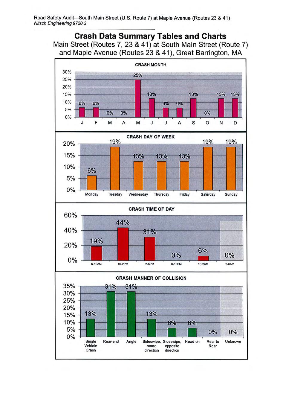
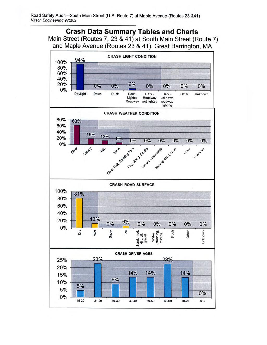
6 Road Safety Audit Main Street (U.S. Route 7, Routes 23 & 41) at South Main Street (U.S. Route 7) and Maple Avenue (Routes 23 & 41) Nitsch Engineering Project Location and Description The Locus Map of the study area is shown in Figure 1. An aerial map of the study location of Main Street (U.S. Route 7, Routes 23 & 41) at South Main Street (U.S. Route 7) and Maple Avenue (Routes 23 & 41) is shown in Figure 2. Main Street/South Main Street (U.S. Route 7) in Great Barrington is classified as a principal arterial that runs in a north-south direction through the project area. Main Street is present from the project intersection northward until its terminus at State Road in Great Barrington, approximately 1 mile to the north. South Main Street is present from the project intersection southward until the Town of Sheffield line, approximately 2 miles to the south, where the roadway continues as North Main Street. U.S. Route 7 is designated as north-south and is present from its northern terminus at Interstate 89 in Highgate, Vermont to its southern terminus at Interstate 95 in Norwalk, Connecticut. Within Massachusetts, U.S. Route 7 is present from the northern border in the Town of Williamstown to the southern border in the town of Sheffield. Main Street/South Main Street (U.S. Route 7) is maintained by the Town of Great Barrington and serves approximately 14,500 vehicles per day north of Maple Avenue and approximately 11,000 vehicles per day south of Maple Avenue. The speed limit along Main Street/South Main Street is 30 miles per hour (mph) in the vicinity of the intersection. Maple Avenue (Routes 23 & 41) in Great Barrington is classified as a rural minor arterial that runs in an east-west direction through the project area. Maple Avenue is present from the project intersection westward until it crosses the Green River in Great Barrington, approximately 1 mile to the west, where the roadway continues as Egremont Road. Within Massachusetts, Route 23 is designated as east-west and is present from its eastern terminus at U.S. Route 20 in Russell to the western border in the Town of Egremont, where it continues into New York as New York State Route 23. Within Massachusetts, Route 41 is designated as north-south and is present from its northern terminus at U.S. Route 20 in Pittsfield to the southern border in the Town of Sheffield, where it continues into Connecticut as Connecticut Route 41. Maple Avenue (Routes 23 & 41) is maintained by the Massachusetts Department of Transportation (MassDOT) and serves approximately 5,500 vehicles per day west Main Street. The speed limit along Maple Avenue is 35 miles per hour (mph) in the vicinity of the intersection. Nitsch Engineering evaluated the last three years of available crash data ( ) from the Town of Great Barrington to establish a crash rate at the intersection to compare to the MassDOT signalized intersection average of 0.80 per Million Entering Vehicles (MEV) Statewide 1. For the three-year period , a total of 16 crashes were documented, yielding a crash rate of 0.93 per MEV, which is above the Statewide average. 1 The 2010 Average Crash Rates, per Million Entering Vehicles, by Intersection Type, MassDOT, Highway Division, for District 1 indicate a low sample total and recommend the use of Statewide Rates only. Page 2
 at South Main St. (U.S. Route 7) and Maple Ave.")
7 Road Safety Audit Main Street (U.S. Route 7, Routes 23 & 41) at South Main Street (U.S. Route 7) and Maple Avenue (Routes 23 & 41) Nitsch Engineering Figure 1: Locus Map Road Safety Audit Main St. (U.S. Route 7, Routes 23 & 41) at South Main St. (U.S. Route 7) and Maple Ave. (Routes 23 & 41) Great Barrington, MA Data Source: MassGIS Nitsch Project # Page 3
 at South Main St. (U.S. Route 7) and Maple Ave.")
8 Road Safety Audit Main Street (U.S. Route 7, Routes 23 & 41) at South Main Street (U.S. Route 7) and Maple Avenue (Routes 23 & 41) Nitsch Engineering Figure 2: Study Location Road Safety Audit Main St. (U.S. Route 7, Routes 23 & 41) at South Main St. (U.S. Route 7) and Maple Ave. (Routes 23 & 41) Great Barrington, MA Data Source: MassGIS Nitsch Project # Page 4


9 Road Safety Audit Main Street (U.S. Route 7, Routes 23 & 41) at South Main Street (U.S. Route 7) and Maple Avenue (Routes 23 & 41) Nitsch Engineering Audit Observations Based on a summary of the existing crash information and site visit, audit participants identified the following safety issues that are summarized below: Intersection Geometry, Visibility, and Traffic Operations: o Due to the angle of the Maple Avenue approach, the high amount of heavy vehicles turning right from Main Street onto Maple Avenue requires a large radius at the northwest corner of the intersection; this large radius also provides the width necessary for left-turning heavy vehicles from South Main Street onto Maple Avenue. This geometric design, however, results in the following safety and operational issues: Right and left-turning heavy vehicles often mount the traffic island on Maple Avenue due to both the geometry of the intersection and the presence of sloped granite curbing around the island, causing damage to existing signage and the pedestrian signal post. Motorists executing the Main Street right-turn movement at a relatively high rate of speed do so as a result of both the large radius and the presence of a right-turn signal arrow during all phases except for the exclusive pedestrian phase. The large radius at the northwest corner, combined with both the sloped area behind the curb and the location of the pedestrian crosswalk, contribute to poor visibility of pedestrians for right-turning vehicles from Main Street onto Maple Avenue. Due to these characteristics, the pedestrian crossing sign located approximately five feet in advance of the crosswalk provides little advanced warning for motorists prior to executing the turn. Looking northbound, the large radius and the sloped area behind the curb contribute to poor visibility of pedestrians crossing Maple Avenue from Main Street right-turning vehicles Looking westbound, the pedestrian crossing sign provides little advanced warning. Sloped granite curbing provides little protection to the signal post and signage within the traffic island Page 5

10 Road Safety Audit Main Street (U.S. Route 7, Routes 23 & 41) at South Main Street (U.S. Route 7) and Maple Avenue (Routes 23 & 41) Nitsch Engineering o o Backplates, which aid in visibility against the adjacent background, are not mounted on any of the traffic signals. Due to the roadway geometry, angle of the traffic signals, and presence of cut-away visors, the signals for South Main Street and Maple Avenue are visible from both approaches, which can create driver confusion. View from Maple Avenue shows the red signals intended for South Main Street can be easily seen from this approach. No back plates on signals. o o There are two (2) signals mounted on the span wire for each of the approaches, however, there are no supplemental post-mounted signals for any of the approaches. MassDOT is currently rehabilitating a portion of Main Street north of the intersection under Project #602182, estimated for completion in July The proximity of this reconstruction project results in traffic queues in the northbound direction through the intersection. Access Management: o Great Barrington Police Station, located on the east side of the project intersection, is not accessible directly from Maple Avenue. To access the Police Station driveway requires a right turn from the de-facto left-turn lane, or a left turn from the channelized right-turn lane, which may confuse nearby drivers. Page 6

11 Road Safety Audit Main Street (U.S. Route 7, Routes 23 & 41) at South Main Street (U.S. Route 7) and Maple Avenue (Routes 23 & 41) Nitsch Engineering o The curb cut on South Main Street for the commercial driveway of the plaza located on the southwest corner of the intersection presents issues with the following: Vehicles exit the site onto South Main Street at roughly the same location where the Main Street southbound lane and the Maple Avenue channelized right-turn lane merge. The excessive driveway width presents no clear path for entering and exiting vehicles. Turning vehicles must execute maneuvers proximate to the intersection. Lane Designation and Pavement Markings: o Due to the excessive width of the single de-facto left-turn approach lane on Maple Avenue and the two (2) northbound receiving lanes on Main Street, left-turning vehicles frequently form two lanes prior to executing the turn. Maple Ave approach is wide enough for vehicles to form two lanes to turn left o o There is no advanced warning for the lane configuration on any of the approaches. This is particularly problematic on the Maple Avenue approach, where the channelized rightturn lane cannot be seen in advance of the intersection. Audit participants observed vehicles executing illegal turns from both approach lanes on Maple Avenue as a result of the separation of the de-facto left-turn lane and channelized right-turn lane. Page 7

12 Road Safety Audit Main Street (U.S. Route 7, Routes 23 & 41) at South Main Street (U.S. Route 7) and Maple Avenue (Routes 23 & 41) Nitsch Engineering o The pavement markings in the vicinity of the traffic islands are faded and the delineation for the gore areas is unclear. The presence of faded markings coupled with the lack of hatching within the gore area, is problematic for Main Street/South Main Street southbound vehicles traveling through the intersection, where it appears two (2) receiving lanes are present. Looking southbound along Main Street, pavement striping can be confused for two receiving lanes Pedestrian Accessibility: o o o o There is no pedestrian signal head on the post located in the traffic island that separates the eastbound and westbound lanes of Maple Avenue. The pedestrian push button at the traffic island that separates the approach lanes for rightand left-turning vehicles on Maple Avenue is not compliant with current standards. The pedestrian signal indications do not contain countdown displays. According to the Signal and Timing Plan, the pedestrian walk interval is seven seconds with a 13 second flashing don t walk clearance, however, based on field observations, the pedestrian walk, flashing don t walk, and clearance timing seem inadequate. Pedestrian ramps are not present at any of the crosswalk termini or within the traffic islands. Page 8

13 Road Safety Audit Main Street (U.S. Route 7, Routes 23 & 41) at South Main Street (U.S. Route 7) and Maple Avenue (Routes 23 & 41) Nitsch Engineering o Some of the sidewalks at the intersection and the pedestrian paths through the traffic islands are difficult to traverse and do not meet current standards. Pedestrian path in traffic island is difficult to traverse; no pedestrian ramp at crosswalk terminus Bicycle Accessibility: o Bicycle accommodation is not present at the intersection. Emergency Vehicle Pre-emption: o Emergency vehicle pre-emption is not present at the intersection. Page 9
14 Road Safety Audit Main Street (U.S. Route 7, Routes 23 & 41) at South Main Street (U.S. Route 7) and Maple Avenue (Routes 23 & 41) Nitsch Engineering Potential Safety Enhancements Following review of crash data and traffic counts and a discussion of potential safety issues, audit participants recommend the following. Redesign the geometry of the intersection taking the following options into consideration: o Realign the intersection such that Maple Avenue intersects Main Street at as close to a 90 degree angle as possible to form a more typical T -type intersection. o Asses the feasibility of re-designing the intersection with a roundabout. Both options would alleviate the operational issues for heavy vehicles turning onto Maple Avenue from Main Street, increase visibility for pedestrians crossing Maple Avenue, reduce travel speed, and would provide accessibility to and from the Great Barrington Police Station. Reconstruct the traffic islands with vertical curb to prevent heavy vehicles from easily mounting the islands. Install a Turning Vehicles Yield to Pedestrians sign on Main Street southbound to give motorists advanced warning for pedestrians crossing Maple Avenue. Realign the crosswalk across Maple Avenue such that the terminus on the north side is closer to the corner to improve visibility for both motorists on Main Street and pedestrians waiting to cross Maple Avenue. Reconstruct the traffic signal system to provide improved visibility of the signals, including backplates for each signal indication and supplemental pole-mounted signals where appropriate. Reduce the width of the curb cut for the commercial plaza driveway on South Main Street, while providing access and egress as far from the intersection as possible to reduce conflicts with vehicles merging from Maple Street eastbound and Main Street southbound. Install a No Left Turn sign at the driveway egress on South Main Street, as vehicles can access the intersection by using the existing curb cut on Maple Avenue. Construct a median island on South Main Street to prevent left-turns from the plaza onto South Main Street. Determine if a second left-turn approach lane on Maple Avenue is warranted, or restripe the gore area at this location to reduce the width of the approach lane. Install advanced warning signage showing lane designations well in advance of the intersection to limit vehicle lane changes close to the intersection. Restripe the intersection to improve visibility of faded pavement markings, including hatching to more clearly define the gore areas around the traffic islands. Page 10
15 Road Safety Audit Main Street (U.S. Route 7, Routes 23 & 41) at South Main Street (U.S. Route 7) and Maple Avenue (Routes 23 & 41) Nitsch Engineering Install a new pedestrian signal system that meets current standards, including a longer walk and clearance time, pedestrian countdown display, push buttons, and signage. Construct new sidewalks at the intersection including the addition of pedestrian ramps at the crosswalk termini and the traffic islands. Reconfigure and/or restripe the intersection and adjacent roadways to accommodate bicycle travel. Install an emergency vehicle pre-emption system. Summary of Road Safety Audit MassDOT has retained Nitsch Engineering to prepare this Road Safety Audit (RSA) for the intersection of Main Street (U.S. Route 7, Routes 23 & 41) at South Main Street (U.S. Route 7) and Maple Avenue (Routes 23 & 41). As part of the RSA process going forward, each of the potential safety enhancements is classified by time frame and cost, as shown in Table 2. Table 2. Time Frame and Costs Breakdown Time Frame Costs Short-term < 1 year Low < $10,000 Mid-term 1-3 years Medium $10,000-$50,000 Long-term > 3 years High > $50,000 The safety issues, potential improvements, estimated safety payoff, time frame, and cost for the intersection of Main Street at South Main Street and Maple Avenue are summarized in Table 3. Page 11
16 Road Safety Audit Main Street (U.S. Route 7, Routes 23 & 41) at South Main Street (U.S. Route 7) and Maple Avenue (Routes 23 & 41) Nitsch Engineering Table 3. Potential Safety Enhancement Summary Main Street (U.S. Route 7, Routes 23 & 41) at South Main Street (U.S. Route 7) and Maple Avenue (Routes 23 & 41) Safety Issue Intersection Geometry, Visibility, and Traffic Operations Access Management Lane Designation and Pavement Markings Safety Enhancement Redesign the geometry of the intersection to alleviate the operational issues for heavy vehicles turning onto Maple Avenue from Main Street, increase visibility for pedestrians crossing Maple Avenue, reduce travel speed, and would provide accessibility to and from the Great Barrington Police Station. Reconstruct the traffic islands with vertical curb to prevent heavy vehicles from easily mounting the islands Install a Turning Vehicles Yield to Pedestrians sign on Main Street southbound to give motorists advanced warning for pedestrians crossing Maple Avenue. Realign the crosswalk across Maple Avenue such that the terminus on the north side is closer to the corner to improve visibility for both motorists on Main Street and pedestrians waiting to cross Maple Avenue. Reconstruct the traffic signal system to provide improved visibility of the signals, including backplates for each signal indication and supplemental pole-mounted signals where appropriate. Reduce the width of the curb cut for the commercial plaza driveway on South Main Street, while providing access and egress as far from the intersection as possible to reduce conflicts with vehicles merging from Maple Street eastbound and Main Street southbound. Install a No Left Turn sign at the driveway egress on South Main Street, as vehicles can access the intersection by using the existing curb cut on Maple Avenue. Construct a median island on South Main Street to prevent leftturns from the plaza onto South Main Street. Determine if a second left-turn approach lane on Maple Avenue is warranted or restripe the gore area at this location to reduce the width of the approach lane. Safety Payoff Time Frame Cost Responsible Agency High Long-term High MassDOT Low Mid-term Medium MassDOT Medium Short-term Low Town of Great Barrington High Mid-Term Medium MassDOT High Long-Term High MassDOT Medium Mid-term Medium Town of Great Barrington Medium Short-term Low MassDOT Page 12
17 Road Safety Audit Main Street (U.S. Route 7, Routes 23 & 41) at South Main Street (U.S. Route 7) and Maple Avenue (Routes 23 & 41) Nitsch Engineering Table 3. Potential Safety Enhancement Summary Main Street (U.S. Route 7, Routes 23 & 41) at South Main Street (U.S. Route 7) and Maple Avenue (Routes 23 & 41) (continued) Safety Issue Lane Designation and Pavement Markings (continued) Pedestrian Accessibility Bicycle Accessibility Safety Enhancement Install advanced warning signage showing lane designations well in advance of the intersection to limit vehicle lane changes close to the intersection. Restripe the intersection to improve visibility of faded pavement markings, including hatching to more clearly define the gore areas around the traffic islands. Install a new pedestrian signal system that meets current standards, including a longer walk and clearance time, pedestrian countdown display, push buttons, and signage. Construct new sidewalks at the intersection including the addition of pedestrian ramps at the crosswalk termini and the traffic islands. Reconfigure and/or re-stripe the intersection and adjacent roadways to accommodate bicycle travel. Safety Payoff Time Frame Cost Medium Short-term Low Medium Short-term Low Responsible Agency MassDOT/Town of Great Barrington MassDOT/Town of Great Barrington Medium Mid-Term High MassDOT Low Mid-term Medium MassDOT Medium Mid-term Medium MassDOT/Town of Great Barrington Emergency Install emergency vehicle pre-emption system High Mid-term High MassDOT Page 13
18
19 ROAD SAFETY AUDIT APPENDIX Main St. (U.S. Route 7, Routes 23 & 41) at South Main St. (U.S. Route 7) and Maple Ave. (Routes 23 & 41) MassDOT Project # Town of Great Barrington August 13, 2015 Prepared For: MassDOT Highway Division Prepared By: Nitsch Engineering 2 Center Plaza, Suite 430 Boston, MA 02108
20
21 Road Safety Audit Main Street (U.S. Route 7, Routes 23 & 41) at South Main Street (U.S. Route 7) and Maple Avenue (Routes 23 & 41) Nitsch Engineering Appendix A: RSA Meeting Agenda
22
23 Road Safety Audit Great Barrington, MA Main Street (Routes 7, 23 & 41) at Maple Avenue (Routes 23 & 41) Meeting Location: Great Barrington Police Department, 465 Main Street, Great Barrington, MA Tuesday, July 21, :30 AM 12:30 PM Type of meeting: Attendees: Please bring: High Crash Location Road Safety Audit Invited Participants to Comprise a Multidisciplinary Team Thoughts and Enthusiasm!! 10:30 AM Welcome and Introductions 10:45 AM Discussion of Safety Issues 11:00 AM Site Visit Crash history, Speed Regulations provided in advance Existing Geometries and Conditions Travel to the intersection of Main Street (Route 7) at Maple Avenue (Routes 23 & 41) As a group, identify areas for improvements 11:45 AM Discussion of Potential Improvements Return to original meeting location Discuss observations and finalize safety issue areas Discuss potential improvements and finalize recommendations 12:30 PM Adjourn for the Day but the RSA has not ended Instructions for Participants: Before attending the RSA on July 21 st, participants are encouraged to drive/walk through the intersection and complete/consider elements on the RSA Prompt List with a focus on safety. All participants will be actively involved in the process throughout. Participants are encouraged to come with thoughts and ideas, but are reminded that the synergy that develops and respect for others opinions are key elements to the success of the overall RSA process. After the RSA meeting, participants will be asked to comment and respond to the document materials to assure it is reflective of the RSA completed by the multidisciplinary team.
24
25 Road Safety Audit Main Street (U.S. Route 7, Routes 23 & 41) at South Main Street (U.S. Route 7) and Maple Avenue (Routes 23 & 41) Nitsch Engineering Appendix B: RSA Audit Team Contact List
26
27 Road Safety Audit Main Street (U.S. Route 7, Routes 23 & 41) at South Main Street (U.S. Route 7) and Maple Avenue (Routes 23 & 41) Nitsch Engineering RSA Sign In Sheet Main Street (Routes 7, 23 & 41) at South Main Street (Route 7) and Maple Avenue (Routes 23 & 41) Great Barrington, MA Tuesday, July 21, :30 a.m. Name Agency/Affiliation Phone Jane Davis Nitsch Engineering Jeff Bandini Nitsch Engineering Kevin Chiang MassDOT Boston Traffic Ops Great Barrington. DPW Joe Sokul Superintendent Clete Kus Berkshire Regional Planning Commission ext. 20 William Walsh Great Barrington Chief of Police Sonja Gray MassDOT District 1 sonja.gray@state.ma.us Peter Frieri MassDOT District 1 peter.frieri@state.ma.us
28
29 Road Safety Audit Main Street (U.S. Route 7, Routes 23 & 41) at South Main Street (U.S. Route 7) and Maple Avenue (Routes 23 & 41) Nitsch Engineering Appendix C: Detailed Crash Data
30
31 (ROUTES 7, 23 & 41) 2 7 MAIN STREET 10 1 MAPLE AVENUE (ROUTES 23 & 41) 8 11, 15 GREAT BARRINGTON POLICE STATION DRIVEWAY (ROUTE 7) SOUTH MAIN STREET 14 COMMERCIAL DRIVEWAY PEDSTRIAN INJURY ACCIDENT FIXED OBJECT SYMBOLS & TYPES OF COLLISIONS: CHANGING LANE MOVING VEHICLE OUT OF CONTROL REAR END BACKING VEHICLE BICYCLE NOT TO SCALE SIDE SWIPE ANGLE PARKED VEHICLE PREPARED FOR: MASSDOT
32 Intersection of Main Street (Routes 7, 23 & 41) at South Main Street (Route 7) and Maple Ave (Routes 23 & 41); Great Barrington, MA -- Information Not Available # Crash Month # Date Crash Day Time of Day Manner of Collision (11) Light Condition (1) Weather Condition (2,3) Road Surface (6) Driver Contributing Code (24) Ages Comments m/d/y # Type # Type # Type # Type # Type D1 D2 D3 D /1/10 Friday 1:00 AM 1 Single Vehicle Crash 4 Dark - lighted roadway 2 Cloudy 1 Dry 7 Driving too fast for conditions 24 Failure to negotiate turn 2 2 2/23/10 Tuesday 1:36 PM 4 Sideswipe, same direction 1 Daylight 4 Snow 4 Ice Failure to keep in proper lane or 9 running off road Poor roadway conditions due to weather 3 8 8/6/10 Friday 2:06 PM 6 Head on 1 Daylight 1 Clear 1 Dry 19 Inattention Driving on wrong side of road 4 9 9/18/10 Saturday 11:48 AM 3 Angle 1 Daylight 1 Clear 1 Dry 19 Inattention Failure to yeild making left turn /22/10 Monday 10:21 AM 5 Sideswipe, opposite direction 1 Daylight 3 Rain 2 Wet Disregarded traffic signs, signals, road 3 markings Failure to stop at a red light /2/10 Thursday 11:38 AM 3 Angle 1 Daylight 1 Clear 1 Dry 4 Failed to yield to right of way Failure to yeild making left turn 7 5 5/10/11 Tuesday 2:04 PM 3 Angle 1 Daylight 1 Clear 1 Dry 99 Unknown /19/11 Thursday 9:28 AM 1 Single Vehicle Crash 1 Daylight 2 Cloudy 1 Dry 19 Inattention 64 Distracted by infant in rear seat 9 5 5/29/11 Sunday 8:16 AM 3 Angle 1 Daylight 1 Clear 1 Dry 99 Unknown Failure to stop at a red light /7/11 Tuesday 4:10 PM 2 Rear-end 1 Daylight 1 Clear 1 Dry 99 Unknown /11/11 Saturday 12:12 PM 2 Rear-end 1 Daylight 2 Cloudy 1 Dry 19 Inattention Rear-ended at red light /31/11 Sunday 4:45 PM 4 Sideswipe, same direction 1 Daylight 1 Clear 1 Dry Failure to keep in proper lane or 9 running off road Improper lane change /18/11 Sunday 4:22 PM 2 Rear-end 1 Daylight 1 Clear 1 Dry 19 Inattention Rear-ended at red light /26/11 Saturday 10:52 AM 2 Rear-end 1 Daylight 1 Clear 1 Dry 99 Unknown /21/11 Wednesday 12:34 PM 2 Rear-end 1 Daylight 3 Rain 2 Wet 99 Unknown /23/12 Wednesday 9:45 AM 3 Angle 1 Daylight 1 Clear 1 Dry 1 No Improper Driving Summary based on Crash Reports obtained from Town of Great Barrington Police Department Crash Data Summary Table
33
34
35
36
37 Road Safety Audit Main Street (U.S. Route 7, Routes 23 & 41) at South Main Street (U.S. Route 7) and Maple Avenue (Routes 23 & 41) Nitsch Engineering Appendix D: Traffic Counts
38
39 MAIN STREET (ROUTES 7, 23 & 41) 21 (23) 402 (476) 188 (184) 336 (497) S 203 (188) 22 (14) MAPLE AVENUE (ROUTES 23 & 41) SOUTH MAIN STREET (ROUTE 7) LEGEND: S SIGNALIZED INTERSECTION XXX (XXX) TRAFFIC DIRECTION TRAFFIC VOLUME - AM (PM) NOT TO SCALE PREPARED FOR: MASSDOT HIGHWAY DIVISION
40 Location: South Main (Route 7) PO Box 468 Location: South of Route 41 Belchertown, Massachusetts Location: Great Barrington, Massachusetts innovativedatallc.com or Client: Nitsch Enginering / S. Farr Start 12-Nov-14 Northbound Southbound Combined 13-Nov Northbound Southbound Combined Time Wed A.M. P.M. A.M. P.M. A.M. P.M. Thu A.M. P.M. A.M. P.M. A.M. P.M. 12: : : : : : : : : : : : : : : : : : : : : : : : : : : : : : : : : : : : : : : : : : : : : : : : Total Day Total % Total 18.9% 30.3% 20.2% 30.6% 18.3% 30.6% 19.7% 31.4% Peak - 07:45 03:15 11:00 03:45 07:45 03:15-07:45 03:45 11:00 03:45 11:00 03:45 Vol P.H.F ADT ADT 11,364 AADT 11,364 Page 1
41 Location: South Main (Route 7) PO Box 468 Location: South of Route 41 Belchertown, Massachusetts Location: Great Barrington, Massachusetts innovativedatallc.com or Client: Nitsch Enginering / S. Farr Northbound Start th 95th Time Total Percent Percent 11/12/ : : : : : : : : : : : PM : : : : : : : : : : : Total Percent 12.7% 6.0% 15.2% 30.7% 27.0% 7.6% 0.6% 0.1% 0.0% 0.0% 0.0% 0.0% 0.0% 0.0% AM Peak 08:00 11:00 11:00 11:00 08:00 08:00 07:00 06:00 00:00 08:00 Vol PM Peak 12:00 12:00 17:00 15:00 14:00 14:00 19:00 14:00 15:00 Vol Page 1
42 Location: South Main (Route 7) PO Box 468 Location: South of Route 41 Belchertown, Massachusetts Location: Great Barrington, Massachusetts innovativedatallc.com or Client: Nitsch Enginering / S. Farr Northbound Start th 95th Time Total Percent Percent 11/13/ : : : : : : : : : : : PM : : : : : : : : : : : Total Percent 9.4% 4.0% 12.8% 35.4% 30.4% 7.3% 0.6% 0.1% 0.0% 0.0% 0.0% 0.0% 0.0% 0.0% AM Peak 07:00 08:00 08:00 11:00 10:00 06:00 06:00 07:00 04:00 08:00 Vol PM Peak 15:00 15:00 17:00 16:00 16:00 13:00 14:00 16:00 Vol Total Percent 11.0% 5.0% 14.0% 33.1% 28.7% 7.4% 0.6% 0.1% 0.0% 0.0% 0.0% 0.0% 0.0% 0.0% 15th Percentile : 18 MPH 50th Percentile : 28 MPH 85th Percentile : 33 MPH 95th Percentile : 37 MPH Stats 10 MPH Pace Speed : MPH Number in Pace : 6886 Percent in Pace : 61.8% Number of Vehicles > 40 MPH : 80 Percent of Vehicles > 40 MPH : 0.7% Mean Speed(Average) : 27 MPH Page 2
43 Location: South Main (Route 7) PO Box 468 Location: South of Route 41 Belchertown, Massachusetts Location: Great Barrington, Massachusetts innovativedatallc.com or Client: Nitsch Enginering / S. Farr Southbound Start th 95th Time Total Percent Percent 11/12/ : : : : : : : : : : : PM : : : : : : : : : : : Total Percent 10.1% 2.1% 5.1% 16.5% 33.6% 22.9% 8.3% 1.2% 0.2% 0.0% 0.0% 0.0% 0.0% 0.0% AM Peak 07:00 07:00 10:00 11:00 10:00 07:00 07:00 07:00 06:00 05:00 00:00 11:00 Vol PM Peak 12:00 13:00 15:00 17:00 14:00 14:00 18:00 15:00 14:00 15:00 Vol Page 3
44 Location: South Main (Route 7) PO Box 468 Location: South of Route 41 Belchertown, Massachusetts Location: Great Barrington, Massachusetts innovativedatallc.com or Client: Nitsch Enginering / S. Farr Southbound Start th 95th Time Total Percent Percent 11/13/ : : : : : : : : : : : PM : : : : : : : : : : : Total Percent 9.0% 2.1% 4.5% 16.3% 33.3% 26.3% 7.1% 1.2% 0.1% 0.0% 0.0% 0.0% 0.0% 0.0% AM Peak 08:00 10:00 11:00 11:00 11:00 07:00 07:00 05:00 05:00 03:00 11:00 Vol PM Peak 15:00 12:00 15:00 15:00 13:00 16:00 16:00 23:00 14:00 18:00 16:00 Vol Total Percent 9.5% 2.1% 4.8% 16.4% 33.4% 24.6% 7.7% 1.2% 0.1% 0.0% 0.0% 0.0% 0.0% 0.0% 15th Percentile : 23 MPH 50th Percentile : 32 MPH 85th Percentile : 38 MPH 95th Percentile : 42 MPH Stats 10 MPH Pace Speed : MPH Number in Pace : 6732 Percent in Pace : 58.1% Number of Vehicles > 40 MPH : 1052 Percent of Vehicles > 40 MPH : 9.1% Mean Speed(Average) : 31 MPH Page 4
45 Location: South Main (Route 7) PO Box 468 Location: South of Route 41 Belchertown, Massachusetts Location: Great Barrington, Massachusetts innovativedatallc.com or Client: Nitsch Enginering / S. Farr Northbound, Southbound Start th 95th Time Total Percent Percent 11/12/ : : : : : : : : : : : PM : : : : : : : : : : : Total Percent 11.4% 4.0% 10.1% 23.5% 30.4% 15.4% 4.5% 0.7% 0.1% 0.0% 0.0% 0.0% 0.0% 0.0% AM Peak 07:00 11:00 11:00 11:00 09:00 07:00 07:00 06:00 00:00 05:00 00:00 11:00 Vol PM Peak 12:00 12:00 17:00 17:00 14:00 14:00 19:00 15:00 14:00 15:00 Vol Page 5
46 Location: South Main (Route 7) PO Box 468 Location: South of Route 41 Belchertown, Massachusetts Location: Great Barrington, Massachusetts innovativedatallc.com or Client: Nitsch Enginering / S. Farr Northbound, Southbound Start th 95th Time Total Percent Percent 11/13/ : : : : : : : : : : : PM : : : : : : : : : : : Total Percent 9.2% 3.1% 8.5% 25.7% 31.9% 17.0% 3.9% 0.7% 0.1% 0.0% 0.0% 0.0% 0.0% 0.0% AM Peak 07:00 08:00 08:00 11:00 10:00 07:00 07:00 05:00 04:00 03:00 11:00 Vol PM Peak 15:00 15:00 15:00 15:00 16:00 16:00 16:00 23:00 14:00 18:00 16:00 Vol Total Percent 10.3% 3.5% 9.3% 24.6% 31.1% 16.2% 4.2% 0.7% 0.1% 0.0% 0.0% 0.0% 0.0% 0.0% 15th Percentile : 20 MPH 50th Percentile : 30 MPH 85th Percentile : 36 MPH 95th Percentile : 39 MPH Stats 10 MPH Pace Speed : MPH Number in Pace : Percent in Pace : 55.7% Number of Vehicles > 40 MPH : 1132 Percent of Vehicles > 40 MPH : 5.0% Mean Speed(Average) : 29 MPH Page 6
47 Location: South Main (Route 7) PO Box 468 Location: South of Route 41 Belchertown, Massachusetts Location: Great Barrington, Massachusetts innovativedatallc.com or Client: Nitsch Enginering / S. Farr Northbound Start Cars & 2 Axle 2 Axle 3 Axle 4 Axle <5 Axl 5 Axle >6 Axl <6 Axl 6 Axle >6 Axl Not Time Bikes Trailers Long Buses 6 Tire Single Single Double Double Double Multi Multi Multi Classed Total 11/12/ : : : : : : : : : : : PM : : : : : : : : : : : Total Percent 2.3% 67.8% 14.9% 0.7% 2.3% 1.3% 0.4% 0.7% 1.2% 0.1% 0.0% 0.0% 0.0% 8.2% AM Peak 07:00 11:00 08:00 07:00 07:00 11:00 07:00 11:00 09:00 07:00 10:00 08:00 08:00 Vol PM Peak 16:00 15:00 15:00 14:00 14:00 16:00 14:00 15:00 12:00 17:00 15:00 12:00 Vol Page 1
48 Location: South Main (Route 7) PO Box 468 Location: South of Route 41 Belchertown, Massachusetts Location: Great Barrington, Massachusetts innovativedatallc.com or Client: Nitsch Enginering / S. Farr Northbound Start Cars & 2 Axle 2 Axle 3 Axle 4 Axle <5 Axl 5 Axle >6 Axl <6 Axl 6 Axle >6 Axl Not Time Bikes Trailers Long Buses 6 Tire Single Single Double Double Double Multi Multi Multi Classed Total 11/13/ : : : : : : : : : : : PM : : : : : : : : : : : Total Percent 2.0% 67.8% 15.0% 0.7% 2.7% 1.5% 0.4% 0.8% 1.2% 0.1% 0.0% 0.0% 0.1% 7.8% AM Peak 08:00 11:00 08:00 07:00 08:00 09:00 08:00 07:00 09:00 08:00 09:00 07:00 Vol PM Peak 16:00 16:00 16:00 13:00 12:00 14:00 12:00 12:00 15:00 12:00 12:00 15:00 Vol Grand Total Percent 2.1% 67.8% 15.0% 0.7% 2.5% 1.4% 0.4% 0.7% 1.2% 0.1% 0.0% 0.0% 0.1% 8.0% Page 2
49 Location: South Main (Route 7) PO Box 468 Location: South of Route 41 Belchertown, Massachusetts Location: Great Barrington, Massachusetts innovativedatallc.com or Client: Nitsch Enginering / S. Farr Southbound Start Cars & 2 Axle 2 Axle 3 Axle 4 Axle <5 Axl 5 Axle >6 Axl <6 Axl 6 Axle >6 Axl Not Time Bikes Trailers Long Buses 6 Tire Single Single Double Double Double Multi Multi Multi Classed Total 11/12/ : : : : : : : : : : : PM : : : : : : : : : : : Total Percent 1.9% 60.7% 16.4% 0.9% 7.6% 1.3% 0.1% 0.8% 1.0% 0.2% 0.0% 0.0% 0.0% 9.0% AM Peak 10:00 11:00 10:00 08:00 06:00 09:00 08:00 08:00 09:00 08:00 09:00 07:00 Vol PM Peak 15:00 17:00 16:00 15:00 14:00 15:00 14:00 13:00 15:00 14:00 12:00 Vol Page 3
50 Location: South Main (Route 7) PO Box 468 Location: South of Route 41 Belchertown, Massachusetts Location: Great Barrington, Massachusetts innovativedatallc.com or Client: Nitsch Enginering / S. Farr Southbound Start Cars & 2 Axle 2 Axle 3 Axle 4 Axle <5 Axl 5 Axle >6 Axl <6 Axl 6 Axle >6 Axl Not Time Bikes Trailers Long Buses 6 Tire Single Single Double Double Double Multi Multi Multi Classed Total 11/13/ : : : : : : : : : : : PM : : : : : : : : : : : Total Percent 1.6% 61.6% 16.7% 0.9% 7.1% 1.0% 0.3% 0.9% 1.4% 0.2% 0.0% 0.0% 0.0% 8.3% AM Peak 11:00 11:00 09:00 11:00 10:00 11:00 08:00 11:00 07:00 01:00 08:00 10:00 Vol PM Peak 12:00 16:00 16:00 15:00 14:00 14:00 15:00 12:00 12:00 13:00 16:00 14:00 15:00 Vol Grand Total Percent 1.7% 61.2% 16.6% 0.9% 7.3% 1.1% 0.2% 0.8% 1.2% 0.2% 0.0% 0.0% 0.0% 8.7% Page 4
51 Location: South Main (Route 7) PO Box 468 Location: South of Route 41 Belchertown, Massachusetts Location: Great Barrington, Massachusetts innovativedatallc.com or Client: Nitsch Enginering / S. Farr Northbound, Southbound Start Cars & 2 Axle 2 Axle 3 Axle 4 Axle <5 Axl 5 Axle >6 Axl <6 Axl 6 Axle >6 Axl Not Time Bikes Trailers Long Buses 6 Tire Single Single Double Double Double Multi Multi Multi Classed Total 11/12/ : : : : : : : : : : : PM : : : : : : : : : : : Total Percent 2.1% 64.2% 15.7% 0.8% 5.0% 1.3% 0.3% 0.8% 1.1% 0.1% 0.0% 0.0% 0.0% 8.6% AM Peak 07:00 11:00 08:00 08:00 06:00 09:00 07:00 11:00 09:00 07:00 10:00 08:00 09:00 07:00 Vol PM Peak 15:00 17:00 15:00 15:00 14:00 16:00 14:00 15:00 15:00 14:00 15:00 12:00 Vol Page 5
52 Location: South Main (Route 7) PO Box 468 Location: South of Route 41 Belchertown, Massachusetts Location: Great Barrington, Massachusetts innovativedatallc.com or Client: Nitsch Enginering / S. Farr Northbound, Southbound Start Cars & 2 Axle 2 Axle 3 Axle 4 Axle <5 Axl 5 Axle >6 Axl <6 Axl 6 Axle >6 Axl Not Time Bikes Trailers Long Buses 6 Tire Single Single Double Double Double Multi Multi Multi Classed Total 11/13/ : : : : : : : : : : : PM : : : : : : : : : : : Total Percent 1.8% 64.6% 15.9% 0.8% 4.9% 1.2% 0.3% 0.8% 1.3% 0.1% 0.0% 0.0% 0.1% 8.1% AM Peak 08:00 11:00 08:00 07:00 10:00 09:00 08:00 07:00 09:00 08:00 08:00 07:00 Vol PM Peak 16:00 16:00 16:00 12:00 14:00 14:00 12:00 12:00 12:00 12:00 16:00 12:00 15:00 Vol Grand Total Percent 1.9% 64.4% 15.8% 0.8% 5.0% 1.3% 0.3% 0.8% 1.2% 0.1% 0.0% 0.0% 0.0% 8.3% Page 6
53 Location: South Main (Route 7) PO Box 468 Location: North of Route 41 Belchertown, Massachusetts Location: Great Barrington, Massachusetts innovativedatallc.com or Client: Nitsch Enginering / S. Farr Start 12-Nov-14 Southbound Northbound Combined 13-Nov Southbound Northbound Combined Time Wed A.M. P.M. A.M. P.M. A.M. P.M. Thu A.M. P.M. A.M. P.M. A.M. P.M. 12: : : : : : : : : : : : : : : : : : : : : : : : : : : : : : : : : : : : : : : : : : : : : : : : Total Day Total % Total 20.3% 30.8% 20.1% 28.8% 19.4% 31.1% 19.2% 30.3% Peak - 07:15 02:30 08:15 02:45 07:45 02:30-07:15 04:15 08:00 03:45 07:30 03:45 Vol P.H.F ADT ADT 14,510 AADT 14,510 Page 1
54 Location: South Main (Route 7) PO Box 468 Location: North of Route 41 Belchertown, Massachusetts Location: Great Barrington, Massachusetts innovativedatallc.com or Client: Nitsch Enginering / S. Farr Southbound Start th 95th Time Total Percent Percent 11/12/ : : : : : : : : : : : PM : : : : : : : : : : : Total Percent 10.8% 2.7% 10.1% 29.9% 34.3% 10.4% 1.6% 0.1% 0.0% 0.0% 0.0% 0.0% 0.0% 0.0% AM Peak 08:00 11:00 10:00 10:00 07:00 07:00 06:00 05:00 06:00 11:00 11:00 Vol PM Peak 17:00 17:00 12:00 13:00 14:00 14:00 14:00 21:00 13:00 14:00 Vol Page 1
55 Location: South Main (Route 7) PO Box 468 Location: North of Route 41 Belchertown, Massachusetts Location: Great Barrington, Massachusetts innovativedatallc.com or Client: Nitsch Enginering / S. Farr Southbound Start th 95th Time Total Percent Percent 11/13/ : : : : : : : : : : : PM : : : : : : : : : : : Total Percent 7.5% 1.2% 7.0% 29.7% 39.9% 13.0% 1.4% 0.2% 0.1% 0.0% 0.0% 0.0% 0.0% 0.0% AM Peak 10:00 07:00 07:00 09:00 08:00 07:00 06:00 07:00 10:00 03:00 11:00 Vol PM Peak 15:00 17:00 16:00 16:00 12:00 12:00 13:00 13:00 15:00 16:00 16:00 Vol Total Percent 9.1% 2.0% 8.5% 29.8% 37.2% 11.8% 1.5% 0.1% 0.0% 0.0% 0.0% 0.0% 0.0% 0.0% 15th Percentile : 22 MPH 50th Percentile : 30 MPH 85th Percentile : 34 MPH 95th Percentile : 38 MPH Stats 10 MPH Pace Speed : MPH Number in Pace : 9879 Percent in Pace : 67.0% Number of Vehicles > 40 MPH : 252 Percent of Vehicles > 40 MPH : 1.7% Mean Speed(Average) : 29 MPH Page 2
56 Location: South Main (Route 7) PO Box 468 Location: North of Route 41 Belchertown, Massachusetts Location: Great Barrington, Massachusetts innovativedatallc.com or Client: Nitsch Enginering / S. Farr Northbound Start th 95th Time Total Percent Percent 11/12/ : : : : : : : : : : : PM : : : : : : : : : : : Total Percent 27.3% 3.1% 6.1% 16.0% 31.7% 13.6% 2.0% 0.1% 0.0% 0.0% 0.0% 0.0% 0.0% 0.0% AM Peak 09:00 10:00 10:00 10:00 08:00 07:00 07:00 05:00 08:00 Vol PM Peak 12:00 17:00 17:00 14:00 14:00 14:00 14:00 20:00 18:00 14:00 Vol Page 3
57 Location: South Main (Route 7) PO Box 468 Location: North of Route 41 Belchertown, Massachusetts Location: Great Barrington, Massachusetts innovativedatallc.com or Client: Nitsch Enginering / S. Farr Northbound Start th 95th Time Total Percent Percent 11/13/ : : : : : : : : : : : PM : : : : : : : : : : : Total Percent 13.9% 0.8% 2.2% 18.3% 44.1% 17.9% 2.5% 0.3% 0.0% 0.0% 0.0% 0.0% 0.0% 0.0% AM Peak 08:00 07:00 11:00 09:00 08:00 10:00 07:00 06:00 11:00 08:00 Vol PM Peak 15:00 14:00 14:00 17:00 16:00 16:00 16:00 12:00 16:00 Vol Total Percent 20.4% 1.9% 4.0% 17.2% 38.2% 15.8% 2.3% 0.2% 0.0% 0.0% 0.0% 0.0% 0.0% 0.0% 15th Percentile : 11 MPH 50th Percentile : 30 MPH 85th Percentile : 36 MPH 95th Percentile : 39 MPH Stats 10 MPH Pace Speed : MPH Number in Pace : 7899 Percent in Pace : 55.3% Number of Vehicles > 40 MPH : 360 Percent of Vehicles > 40 MPH : 2.5% Mean Speed(Average) : 27 MPH Page 4
58 Location: South Main (Route 7) PO Box 468 Location: North of Route 41 Belchertown, Massachusetts Location: Great Barrington, Massachusetts innovativedatallc.com or Client: Nitsch Enginering / S. Farr Southbound, Northbound Start th 95th Time Total Percent Percent 11/12/ : : : : : : : : : : : PM : : : : : : : : : : : Total Percent 18.8% 2.9% 8.1% 23.1% 33.0% 12.0% 1.8% 0.1% 0.0% 0.0% 0.0% 0.0% 0.0% 0.0% AM Peak 09:00 10:00 10:00 10:00 08:00 07:00 07:00 05:00 06:00 11:00 08:00 Vol PM Peak 16:00 17:00 17:00 14:00 14:00 14:00 14:00 20:00 18:00 13:00 14:00 Vol Page 5
59 Location: South Main (Route 7) PO Box 468 Location: North of Route 41 Belchertown, Massachusetts Location: Great Barrington, Massachusetts innovativedatallc.com or Client: Nitsch Enginering / S. Farr Southbound, Northbound Start th 95th Time Total Percent Percent 11/13/ : : : : : : : : : : : PM : : : : : : : : : : : Total Percent 10.7% 1.0% 4.6% 24.0% 42.0% 15.4% 2.0% 0.2% 0.0% 0.0% 0.0% 0.0% 0.0% 0.0% AM Peak 10:00 07:00 07:00 09:00 08:00 07:00 07:00 06:00 10:00 03:00 11:00 Vol PM Peak 15:00 14:00 14:00 17:00 16:00 16:00 16:00 13:00 15:00 16:00 16:00 Vol Total Percent 14.6% 1.9% 6.3% 23.6% 37.7% 13.8% 1.9% 0.2% 0.0% 0.0% 0.0% 0.0% 0.0% 0.0% 15th Percentile : 15 MPH 50th Percentile : 30 MPH 85th Percentile : 35 MPH 95th Percentile : 38 MPH Stats 10 MPH Pace Speed : MPH Number in Pace : Percent in Pace : 61.2% Number of Vehicles > 40 MPH : 612 Percent of Vehicles > 40 MPH : 2.1% Mean Speed(Average) : 28 MPH Page 6
60 Location: South Main (Route 7) PO Box 468 Location: North of Route 41 Belchertown, Massachusetts Location: Great Barrington, Massachusetts innovativedatallc.com or Client: Nitsch Enginering / S. Farr Southbound Start Cars 2 Axle 2 Axle 3 Axle 4 Axle <5 Axl 5 Axle >6 Axl <6 Axl 6 Axle >6 Axl Not Time Motor Trailer Long Buses 6 Tire Single Single Doubl Doubl Doubl Multi Multi Multi Bicycl Class Total 11/12/ : : : : : : : : : : : PM : : : : : : : : : : : Total Percent 0.4% 69.3% 14.9% 0.8% 2.8% 0.9% 0.1% 0.9% 0.6% 0.1% 0.0% 0.0% 0.1% 0.5% 8.4% Page 1
61 Location: South Main (Route 7) PO Box 468 Location: North of Route 41 Belchertown, Massachusetts Location: Great Barrington, Massachusetts innovativedatallc.com or Client: Nitsch Enginering / S. Farr Southbound Start Cars 2 Axle 2 Axle 3 Axle 4 Axle <5 Axl 5 Axle >6 Axl <6 Axl 6 Axle >6 Axl Not Time Motor Trailer Long Buses 6 Tire Single Single Doubl Doubl Doubl Multi Multi Multi Bicycl Class Total 11/13/ : : : : : : : : : : : PM : : : : : : : : : : : Total Percent 0.6% 69.7% 15.8% 0.8% 3.0% 0.9% 0.1% 0.9% 0.8% 0.1% 0.0% 0.0% 0.0% 0.3% 7.0% Total Percent 0.5% 69.5% 15.4% 0.8% 2.9% 0.9% 0.1% 0.9% 0.7% 0.1% 0.0% 0.0% 0.1% 0.4% 7.7% Page 2
62 Location: South Main (Route 7) PO Box 468 Location: North of Route 41 Belchertown, Massachusetts Location: Great Barrington, Massachusetts innovativedatallc.com or Client: Nitsch Enginering / S. Farr Northbound Start Cars 2 Axle 2 Axle 3 Axle 4 Axle <5 Axl 5 Axle >6 Axl <6 Axl 6 Axle >6 Axl Not Time Motor Trailer Long Buses 6 Tire Single Single Doubl Doubl Doubl Multi Multi Multi Bicycl Class Total 11/12/ : : : : : : : : : : : PM : : : : : : : : : : : Total Percent 0.5% 60.1% 14.2% 0.7% 2.5% 0.6% 0.1% 0.6% 0.5% 0.1% 0.0% 0.0% 0.0% 0.9% 19.2% Page 3
63 Location: South Main (Route 7) PO Box 468 Location: North of Route 41 Belchertown, Massachusetts Location: Great Barrington, Massachusetts innovativedatallc.com or Client: Nitsch Enginering / S. Farr Northbound Start Cars 2 Axle 2 Axle 3 Axle 4 Axle <5 Axl 5 Axle >6 Axl <6 Axl 6 Axle >6 Axl Not Time Motor Trailer Long Buses 6 Tire Single Single Doubl Doubl Doubl Multi Multi Multi Bicycl Class Total 11/13/ : : : : : : : : : : : PM : : : : : : : : : : : Total Percent 0.4% 65.6% 15.7% 0.7% 3.2% 0.6% 0.2% 1.0% 0.7% 0.1% 0.0% 0.0% 0.0% 0.5% 11.3% Total Percent 0.4% 63.0% 15.0% 0.7% 2.9% 0.6% 0.1% 0.8% 0.6% 0.1% 0.0% 0.0% 0.0% 0.7% 15.1% Page 4
64 Location: South Main (Route 7) PO Box 468 Location: North of Route 41 Belchertown, Massachusetts Location: Great Barrington, Massachusetts innovativedatallc.com or Client: Nitsch Enginering / S. Farr Southbound, Northbound Start Cars 2 Axle 2 Axle 3 Axle 4 Axle <5 Axl 5 Axle >6 Axl <6 Axl 6 Axle >6 Axl Not Time Motor Trailer Long Buses 6 Tire Single Single Doubl Doubl Doubl Multi Multi Multi Bicycl Class Total 11/12/ : : : : : : : : : : : PM : : : : : : : : : : : Total Percent 0.4% 64.8% 14.6% 0.8% 2.7% 0.7% 0.1% 0.7% 0.5% 0.1% 0.0% 0.0% 0.0% 0.7% 13.7% Page 5
65 Location: South Main (Route 7) PO Box 468 Location: North of Route 41 Belchertown, Massachusetts Location: Great Barrington, Massachusetts innovativedatallc.com or Client: Nitsch Enginering / S. Farr Southbound, Northbound Start Cars 2 Axle 2 Axle 3 Axle 4 Axle <5 Axl 5 Axle >6 Axl <6 Axl 6 Axle >6 Axl Not Time Motor Trailer Long Buses 6 Tire Single Single Doubl Doubl Doubl Multi Multi Multi Bicycl Class Total 11/13/ : : : : : : : : : : : PM : : : : : : : : : : : Total Percent 0.5% 67.7% 15.7% 0.7% 3.1% 0.8% 0.1% 0.9% 0.7% 0.1% 0.0% 0.0% 0.0% 0.4% 9.1% Total Percent 0.5% 66.3% 15.2% 0.8% 2.9% 0.8% 0.1% 0.9% 0.6% 0.1% 0.0% 0.0% 0.0% 0.5% 11.3% Page 6
66 Location: Maple Ave (Route 41) PO Box 468 Location: West of Route 7 Belchertown, Massachusetts Location: Great Barrington, Massachusetts innovativedatallc.com or Client: Nitsch Enginering / S. Farr Start 12-Nov-14 Westbound Eastbound Combined 13-Nov Westbound Eastbound Combined Time Wed A.M. P.M. A.M. P.M. A.M. P.M. Thu A.M. P.M. A.M. P.M. A.M. P.M. 12: : : : : : : : : : : : : : : : : : : : : : : : : : : : : : : : : : : : : : : : : : : : : : : : Total Day Total % Total 18.5% 32.8% 20.2% 28.6% 18.1% 32.6% 20.6% 28.7% Peak - 07:30 04:00 08:00 03:45 08:00 03:45-07:45 02:45 08:15 03:00 08:00 03:00 Vol P.H.F ADT ADT 5,585 AADT 5,585 Page 1
67 Location: Maple Ave (Route 41) PO Box 468 Location: West of Route 7 Belchertown, Massachusetts Location: Great Barrington, Massachusetts innovativedatallc.com or Client: Nitsch Enginering / S. Farr Westbound Start th 95th Time Total Percent Percent 11/12/ : : : : : : : : : : : PM : : : : : : : : : : : Total Percent 6.0% 6.3% 14.0% 28.2% 32.5% 11.5% 1.3% 0.2% 0.0% 0.0% 0.0% 0.0% 0.0% 0.0% AM Peak 09:00 10:00 09:00 11:00 09:00 08:00 06:00 06:00 08:00 Vol PM Peak 13:00 12:00 12:00 16:00 17:00 14:00 16:00 13:00 16:00 Vol Page 1
68 Location: Maple Ave (Route 41) PO Box 468 Location: West of Route 7 Belchertown, Massachusetts Location: Great Barrington, Massachusetts innovativedatallc.com or Client: Nitsch Enginering / S. Farr Westbound Start th 95th Time Total Percent Percent 11/13/ : : : : : : : : : : : PM : : : : : : : : : : : Total Percent 13.2% 5.0% 12.0% 23.1% 32.8% 12.7% 1.2% 0.1% 0.0% 0.0% 0.0% 0.0% 0.0% 0.0% AM Peak 11:00 11:00 08:00 11:00 09:00 08:00 10:00 09:00 08:00 Vol PM Peak 21:00 12:00 15:00 15:00 16:00 16:00 18:00 12:00 15:00 Vol Total Percent 9.6% 5.6% 13.0% 25.6% 32.6% 12.1% 1.2% 0.1% 0.0% 0.0% 0.0% 0.0% 0.0% 0.0% 15th Percentile : 19 MPH 50th Percentile : 29 MPH 85th Percentile : 34 MPH 95th Percentile : 38 MPH Stats 10 MPH Pace Speed : MPH Number in Pace : 3320 Percent in Pace : 58.3% Number of Vehicles > 40 MPH : 79 Percent of Vehicles > 40 MPH : 1.4% Mean Speed(Average) : 28 MPH Page 2
69 Location: Maple Ave (Route 41) PO Box 468 Location: West of Route 7 Belchertown, Massachusetts Location: Great Barrington, Massachusetts innovativedatallc.com or Client: Nitsch Enginering / S. Farr Eastbound Start th 95th Time Total Percent Percent 11/12/ : : : : : : : : : : : PM : : : : : : : : : : : Total Percent 11.7% 13.4% 24.4% 33.7% 14.9% 1.7% 0.3% 0.0% 0.0% 0.0% 0.0% 0.0% 0.0% 0.0% AM Peak 08:00 09:00 08:00 08:00 08:00 10:00 08:00 08:00 Vol PM Peak 12:00 12:00 15:00 14:00 18:00 15:00 16:00 15:00 Vol Page 3
70 Location: Maple Ave (Route 41) PO Box 468 Location: West of Route 7 Belchertown, Massachusetts Location: Great Barrington, Massachusetts innovativedatallc.com or Client: Nitsch Enginering / S. Farr Eastbound Start th 95th Time Total Percent Percent 11/13/ : : * * 03: : : : : : : : : PM : : : : : : : : : * * 22: * * 23: * * Total Percent 9.1% 13.3% 24.5% 34.7% 16.0% 2.3% 0.2% 0.0% 0.0% 0.0% 0.0% 0.0% 0.0% 0.0% AM Peak 11:00 08:00 11:00 08:00 07:00 08:00 00:00 08:00 Vol PM Peak 15:00 15:00 15:00 13:00 16:00 17:00 16:00 15:00 Vol Total Percent 10.3% 13.3% 24.4% 34.2% 15.5% 2.0% 0.2% 0.0% 0.0% 0.0% 0.0% 0.0% 0.0% 0.0% 15th Percentile : 16 MPH 50th Percentile : 25 MPH 85th Percentile : 30 MPH 95th Percentile : 34 MPH Stats 10 MPH Pace Speed : MPH Number in Pace : 3211 Percent in Pace : 58.7% Number of Vehicles > 40 MPH : 12 Percent of Vehicles > 40 MPH : 0.2% Mean Speed(Average) : 24 MPH Page 4
71 Location: Maple Ave (Route 41) PO Box 468 Location: West of Route 7 Belchertown, Massachusetts Location: Great Barrington, Massachusetts innovativedatallc.com or Client: Nitsch Enginering / S. Farr Westbound, Eastbound Start th 95th Time Total Percent Percent 11/12/ : : : : : : : : : : : PM : : : : : : : : : : : Total Percent 8.8% 9.8% 19.0% 30.9% 23.9% 6.8% 0.8% 0.1% 0.0% 0.0% 0.0% 0.0% 0.0% 0.0% AM Peak 08:00 10:00 09:00 08:00 08:00 08:00 08:00 06:00 08:00 Vol PM Peak 12:00 12:00 12:00 16:00 18:00 14:00 16:00 13:00 16:00 Vol Page 5
72 Location: Maple Ave (Route 41) PO Box 468 Location: West of Route 7 Belchertown, Massachusetts Location: Great Barrington, Massachusetts innovativedatallc.com or Client: Nitsch Enginering / S. Farr Westbound, Eastbound Start th 95th Time Total Percent Percent 11/13/ : : : : : : : : : : : PM : : : : : : : : : : : Total Percent 11.1% 9.1% 18.1% 28.8% 24.5% 7.6% 0.7% 0.1% 0.0% 0.0% 0.0% 0.0% 0.0% 0.0% AM Peak 11:00 08:00 08:00 08:00 09:00 08:00 10:00 09:00 08:00 Vol PM Peak 21:00 15:00 15:00 13:00 16:00 16:00 16:00 12:00 15:00 Vol Total Percent 10.0% 9.4% 18.6% 29.8% 24.2% 7.2% 0.7% 0.1% 0.0% 0.0% 0.0% 0.0% 0.0% 0.0% 15th Percentile : 17 MPH 50th Percentile : 27 MPH 85th Percentile : 33 MPH 95th Percentile : 37 MPH Stats 10 MPH Pace Speed : MPH Number in Pace : 6040 Percent in Pace : 54.1% Number of Vehicles > 40 MPH : 91 Percent of Vehicles > 40 MPH : 0.8% Mean Speed(Average) : 26 MPH Page 6
73 Location: Maple Ave (Route 41) PO Box 468 Location: West of Route 7 Belchertown, Massachusetts Location: Great Barrington, Massachusetts innovativedatallc.com or Client: Nitsch Enginering / S. Farr Westbound Start Cars & 2 Axle 2 Axle 3 Axle 4 Axle <5 Axl 5 Axle >6 Axl <6 Axl 6 Axle >6 Axl Not Time Bikes Trailers Long Buses 6 Tire Single Single Double Double Double Multi Multi Multi Classed Total 11/12/ : : : : : : : : : : : PM : : : : : : : : : : : Total Percent 1.0% 66.8% 19.5% 1.3% 4.0% 1.0% 0.6% 0.5% 0.8% 0.0% 0.0% 0.0% 0.0% 4.4% AM Peak 07:00 11:00 08:00 11:00 11:00 09:00 07:00 07:00 09:00 07:00 08:00 Vol PM Peak 12:00 16:00 16:00 12:00 16:00 12:00 13:00 16:00 16:00 13:00 Vol Page 1
74 Location: Maple Ave (Route 41) PO Box 468 Location: West of Route 7 Belchertown, Massachusetts Location: Great Barrington, Massachusetts innovativedatallc.com or Client: Nitsch Enginering / S. Farr Westbound Start Cars & 2 Axle 2 Axle 3 Axle 4 Axle <5 Axl 5 Axle >6 Axl <6 Axl 6 Axle >6 Axl Not Time Bikes Trailers Long Buses 6 Tire Single Single Double Double Double Multi Multi Multi Classed Total 11/13/ : : : : : : : : : : : PM : : : : : : : : : : : Total Percent 0.7% 62.1% 17.7% 0.9% 3.8% 1.1% 0.2% 0.6% 1.3% 0.1% 0.0% 0.0% 0.0% 11.5% AM Peak 08:00 08:00 08:00 07:00 11:00 10:00 07:00 06:00 09:00 08:00 10:00 Vol PM Peak 12:00 15:00 12:00 12:00 15:00 12:00 12:00 12:00 15:00 13:00 21:00 Vol Grand Total Percent 0.8% 64.5% 18.6% 1.1% 3.9% 1.1% 0.4% 0.6% 1.1% 0.1% 0.0% 0.0% 0.0% 7.9% Page 2
75 Location: Maple Ave (Route 41) PO Box 468 Location: West of Route 7 Belchertown, Massachusetts Location: Great Barrington, Massachusetts innovativedatallc.com or Client: Nitsch Enginering / S. Farr Eastbound Start Cars & 2 Axle 2 Axle 3 Axle 4 Axle <5 Axl 5 Axle >6 Axl <6 Axl 6 Axle >6 Axl Not Time Bikes Trailers Long Buses 6 Tire Single Single Double Double Double Multi Multi Multi Classed Total 11/12/ : : : : : : : : : : : PM : : : : : : : : : : : Total Percent 1.6% 68.8% 16.3% 0.9% 3.2% 1.2% 0.1% 0.4% 0.9% 0.1% 0.0% 0.0% 0.0% 6.5% AM Peak 10:00 08:00 08:00 07:00 08:00 10:00 10:00 09:00 04:00 08:00 Vol PM Peak 12:00 15:00 15:00 15:00 12:00 12:00 12:00 17:00 13:00 13:00 13:00 Vol Page 3
76 Location: Maple Ave (Route 41) PO Box 468 Location: West of Route 7 Belchertown, Massachusetts Location: Great Barrington, Massachusetts innovativedatallc.com or Client: Nitsch Enginering / S. Farr Eastbound Start Cars & 2 Axle 2 Axle 3 Axle 4 Axle <5 Axl 5 Axle >6 Axl <6 Axl 6 Axle >6 Axl Not Time Bikes Trailers Long Buses 6 Tire Single Single Double Double Double Multi Multi Multi Classed Total 11/13/ : : : : : : : : : : : PM : : : : : : : : : : : Total Percent 1.2% 70.0% 16.2% 0.9% 3.2% 1.7% 0.1% 0.5% 1.2% 0.2% 0.0% 0.0% 0.0% 4.7% AM Peak 08:00 11:00 08:00 09:00 10:00 08:00 08:00 08:00 08:00 08:00 09:00 Vol PM Peak 15:00 15:00 13:00 12:00 12:00 13:00 12:00 14:00 13:00 13:00 15:00 Vol Grand Total Percent 1.4% 69.4% 16.2% 0.9% 3.2% 1.5% 0.1% 0.5% 1.1% 0.1% 0.0% 0.0% 0.0% 5.6% Page 4
77 Location: Maple Ave (Route 41) PO Box 468 Location: West of Route 7 Belchertown, Massachusetts Location: Great Barrington, Massachusetts innovativedatallc.com or Client: Nitsch Enginering / S. Farr Westbound, Eastbound Start Cars & 2 Axle 2 Axle 3 Axle 4 Axle <5 Axl 5 Axle >6 Axl <6 Axl 6 Axle >6 Axl Not Time Bikes Trailers Long Buses 6 Tire Single Single Double Double Double Multi Multi Multi Classed Total 11/12/ : : : : : : : : : : : PM : : : : : : : : : : : Total Percent 1.3% 67.8% 17.9% 1.1% 3.6% 1.1% 0.3% 0.5% 0.9% 0.1% 0.0% 0.0% 0.0% 5.4% AM Peak 10:00 08:00 08:00 11:00 11:00 09:00 10:00 09:00 08:00 07:00 08:00 Vol PM Peak 12:00 16:00 16:00 14:00 16:00 12:00 13:00 17:00 13:00 13:00 13:00 Vol Page 5
78 Location: Maple Ave (Route 41) PO Box 468 Location: West of Route 7 Belchertown, Massachusetts Location: Great Barrington, Massachusetts innovativedatallc.com or Client: Nitsch Enginering / S. Farr Westbound, Eastbound Start Cars & 2 Axle 2 Axle 3 Axle 4 Axle <5 Axl 5 Axle >6 Axl <6 Axl 6 Axle >6 Axl Not Time Bikes Trailers Long Buses 6 Tire Single Single Double Double Double Multi Multi Multi Classed Total 11/13/ : : : : : : : : : : : PM : : : : : : : : : : : Total Percent 0.9% 66.0% 17.0% 0.9% 3.5% 1.4% 0.1% 0.6% 1.3% 0.1% 0.0% 0.0% 0.0% 8.1% AM Peak 08:00 11:00 08:00 07:00 10:00 08:00 07:00 08:00 08:00 08:00 10:00 Vol PM Peak 12:00 15:00 13:00 12:00 15:00 13:00 12:00 16:00 15:00 13:00 21:00 Vol Grand Total Percent 1.1% 66.9% 17.4% 1.0% 3.6% 1.3% 0.2% 0.5% 1.1% 0.1% 0.0% 0.0% 0.0% 6.8% Page 6
79 PO Box 468 Belchertown, Massachusetts innovativedatall.com or N / S: South Main (Route 7) File Name : AM Peak - South Maple E / W: Maple Ave (Route 41) Site Code : 1 City, State: Great Barrington, MA Start Date : 11/12/2014 Client: Nitsch Engineering / S. Farr Page No : 1 Groups Printed- PCs and Peds - Heavy Vehicles - Bicycles Route 7 Route 7 Route 41 From North From East From South From West Start Time Right Thru Left Peds App. Total Right Thru Left Peds App. Total Right Thru Left Peds App. Total Right Thru Left Peds App. Total Int. Total 07:00 AM :15 AM :30 AM :45 AM Total :00 AM :15 AM :30 AM :45 AM Total :00 AM :15 AM :30 AM :45 AM Total :00 AM :15 AM :30 AM :45 AM Total Grand Total Apprch % Total % PCs and Peds % PCs and Peds Heavy Vehicles % Heavy Vehicles Bicycles % Bicycles Route 7 Route 7 Route 41 From North From East From South From West Start Time Right Thru Left Peds App. Total Right Thru Left Peds App. Total Right Thru Left Peds App. Total Right Thru Left Peds App. Total Int. Total Peak Hour Analysis From 07:00 AM to 10:45 AM - Peak 1 of 1 Peak Hour for Entire Intersection Begins at 07:45 AM 07:45 AM :00 AM :15 AM :30 AM Total Volume % App. Total PHF
80 PO Box 468 Belchertown, Massachusetts innovativedatall.com or N / S: South Main (Route 7) File Name : AM Peak - South Maple E / W: Maple Ave (Route 41) Site Code : 1 City, State: Great Barrington, MA Start Date : 11/12/2014 Client: Nitsch Engineering / S. Farr Page No : 1 Groups Printed- Heavy Vehicles Route 7 Route 7 Route 41 From North From East From South From West Start Time Right Thru Left Peds App. Total Right Thru Left Peds App. Total Right Thru Left Peds App. Total Right Thru Left Peds App. Total Int. Total 07:00 AM :15 AM :30 AM :45 AM Total :00 AM :15 AM :30 AM :45 AM Total :00 AM :15 AM :30 AM :45 AM Total :00 AM :15 AM :30 AM :45 AM Total Grand Total Apprch % Total % Route 7 Route 7 Route 41 From North From East From South From West Start Time Right Thru Left Peds App. Total Right Thru Left Peds App. Total Right Thru Left Peds App. Total Right Thru Left Peds App. Total Int. Total Peak Hour Analysis From 07:00 AM to 10:45 AM - Peak 1 of 1 Peak Hour for Entire Intersection Begins at 07:15 AM 07:15 AM :30 AM :45 AM :00 AM Total Volume % App. Total PHF
81 PO Box 468 Belchertown, Massachusetts innovativedatall.com or N / S: South Main (Route 7) File Name : PM Peak - South Maple E / W: Maple Ave (Route 41) Site Code : 2 City, State: Great Barrington, MA Start Date : 11/12/2014 Client: Nitsch Engineering / S. Farr Page No : 1 Groups Printed- PCs and Peds - Heavy Vehicles - Bicycles Route 7 Route 7 Route 41 From North From East From South From West Start Time Right Thru Left Peds App. Total Right Thru Left Peds App. Total Right Thru Left Peds App. Total Right Thru Left Peds App. Total Int. Total 03:00 PM :15 PM :30 PM :45 PM Total :00 PM :15 PM :30 PM :45 PM Total :00 PM :15 PM :30 PM :45 PM Total :00 PM :15 PM :30 PM :45 PM Total Grand Total Apprch % Total % PCs and Peds % PCs and Peds Heavy Vehicles % Heavy Vehicles Bicycles % Bicycles Route 7 Route 7 Route 41 From North From East From South From West Start Time Right Thru Left Peds App. Total Right Thru Left Peds App. Total Right Thru Left Peds App. Total Right Thru Left Peds App. Total Int. Total Peak Hour Analysis From 03:00 PM to 06:45 PM - Peak 1 of 1 Peak Hour for Entire Intersection Begins at 04:45 PM 04:45 PM :00 PM :15 PM :30 PM Total Volume % App. Total PHF
 File Name : PM Peak - South Main @ Maple E / W: Maple Ave (Route 41) Site Code : 2 City, State: Great Barrington, MA Start Date : 11/12/2014 Client: Nitsch")
82 PO Box 468 Belchertown, Massachusetts innovativedatall.com or N / S: South Main (Route 7) File Name : PM Peak - South Maple E / W: Maple Ave (Route 41) Site Code : 2 City, State: Great Barrington, MA Start Date : 11/12/2014 Client: Nitsch Engineering / S. Farr Page No : 1 Groups Printed- Heavy Vehicles Route 7 Route 7 Route 41 From North From East From South From West Start Time Right Thru Left Peds App. Total Right Thru Left Peds App. Total Right Thru Left Peds App. Total Right Thru Left Peds App. Total Int. Total 03:00 PM :15 PM :30 PM :45 PM Total :00 PM :15 PM :30 PM :45 PM Total :00 PM :15 PM :30 PM :45 PM Total :00 PM :15 PM :30 PM :45 PM Total Grand Total Apprch % Total % Route 7 Route 7 Route 41 From North From East From South From West Start Time Right Thru Left Peds App. Total Right Thru Left Peds App. Total Right Thru Left Peds App. Total Right Thru Left Peds App. Total Int. Total Peak Hour Analysis From 03:00 PM to 06:45 PM - Peak 1 of 1 Peak Hour for Entire Intersection Begins at 03:00 PM 03:00 PM :15 PM :30 PM :45 PM Total Volume % App. Total PHF
Speed Limit and Safety Nexus Studies for Automated Enforcement Locations in the District of Columbia 3rd Street Tunnel at Massachusetts Avenue Exit
 Speed Limit and Safety Nexus Studies for Automated Enforcement Locations in the District of Columbia 3rd Street Tunnel at Massachusetts Avenue Exit Study Area and Location District PSA Ward ANC Phase Description
Speed Limit and Safety Nexus Studies for Automated Enforcement Locations in the District of Columbia 400 Block 14th Street SW
 Speed Limit and Safety Nexus Studies for Automated Enforcement Locations in the District of Columbia 4 Block 4th Street SW Study Area and Location District PSA Ward ANC Phase Description 27 6 6D Existing
Study Area and Location District PSA Ward ANC Phase Description C Planned Suitland Parkway Westbound at Stanton Road Southeast
 Speed Limit and Safety Nexus Studies for Automated Enforcement Locations in the District of Columbia Suitland Parkway at Stanton Road SE Study Area and Location District PSA Ward ANC Phase Description
Study Area and Location District PSA Ward ANC Phase Description B Existing 600 Block New York Avenue Northeast Westbound
 Speed Limit and Safety Nexus Studies for Automated Enforcement Locations in the District of Columbia 6 Block New York Avenue NE Study Area and Location District PSA Ward ANC Phase Description 5 55 5 5B
Study Area and Location District PSA Ward ANC Phase Description C Existing 100 Block Michigan Avenue Northeast Westbound
 Speed Limit and Safety Nexus Studies for Automated Enforcement Locations in the District of Columbia 1 Block Michigan Avenue NE W/B Study Area and Location District PSA Ward ANC Phase Description 5 45
Study Area and Location District PSA Ward ANC Phase Description B Existing 3700 Block Massachusetts Avenue Southeast Southeast-bound
 Speed Limit and Safety Nexus Studies for Automated Enforcement Locations in the District of Columbia 37 Block Massachusetts Avenue SE Study Area and Location District PSA Ward ANC Phase Description 6 65
ROAD SAFETY AUDIT. Dascomb Road (Frontage Road to I-93 NB Ramps) Town of Andover. March 29, 2017
 Town of Andover. March 29, 2017") ROAD SAFETY AUDIT Dascomb Road (Frontage Road to I-93 NB Ramps) Town of Andover March 29, 2017 Prepared For: Massachusetts Department of Transportation Town of Andover, Massachusetts Prepared By: TEC,
ROAD SAFETY AUDIT Dascomb Road (Frontage Road to I-93 NB Ramps) Town of Andover March 29, 2017 Prepared For: Massachusetts Department of Transportation Town of Andover, Massachusetts Prepared By: TEC,
Figure 1 Map of intersection of SR 44 (Ravenna Rd) and Butternut Rd
 and Butternut Rd") Abbreviated Study District: 12 County: Geauga Route: SR 44 Section: 1.58 GEA 44 1.58 213 HSP # 47 (Rural Intersection) Prepared April 23, 215 By Bryan Emery Existing Conditions This study contains the
Abbreviated Study District: 12 County: Geauga Route: SR 44 Section: 1.58 GEA 44 1.58 213 HSP # 47 (Rural Intersection) Prepared April 23, 215 By Bryan Emery Existing Conditions This study contains the
Study Area and Location District PSA Ward ANC Phase Description C Proposed 2600 Block Lincoln Road Northeast Northbound
 Speed Limit and Safety Nexus Studies for Automated Enforcement Locations in the District of Columbia 2600 Block Lincoln Road NE Study Area and Location District PSA Ward ANC Phase Description 5 502 5 5C
ROAD SAFETY AUDIT. Middlesex Turnpike between Wheeler Road (East) and I-95 Southbound Ramps Town of Burlington. December 21, 2012
 and I-95 Southbound Ramps Town of Burlington. December 21, 2012") ROAD SAFETY AUDIT Middlesex Turnpike between Wheeler Road (East) and I-95 Southbound Ramps Town of Burlington December 21, 212 Prepared For: The Gutierrez Company Prepared By: TEC, Inc. 65 Glenn Street
ROAD SAFETY AUDIT Middlesex Turnpike between Wheeler Road (East) and I-95 Southbound Ramps Town of Burlington December 21, 212 Prepared For: The Gutierrez Company Prepared By: TEC, Inc. 65 Glenn Street
Traffic Impact Study Speedway Gas Station Redevelopment
 Traffic Impact Study Speedway Gas Station Redevelopment Warrenville, Illinois Prepared For: Prepared By: April 11, 2018 Table of Contents 1. Introduction... 1 2. Existing Conditions... 4 Site Location...
Study Area and Location District PSA Ward ANC Phase Description A Proposed Monroe Street Northeast Eastbound at Rhode Island Avenue
 Speed Limit and Safety Nexus Studies for Automated Enforcement Locations in the District of Columbia Monroe Street NE and Rhode Island Avenue NE Study Area and Location District PSA Ward ANC Phase Description
Speed Limit Study: Traffic Engineering Report
 Speed Limit Study: Traffic Engineering Report This report documents the engineering and traffic investigation required by Vermont Statutes Annotated Title 23, Chapter 13 1007 for a municipal legislative
W District Department of Transportation 55 M Street, SE, Suite 400 Washington, DC 20003
 Speed Limit and Safety Nexus Studies for Automated Enforcement Locations in the District of Columbia 35 Block Martin Luther King, Jr. Avenue SE SW/B Study Area and Location District PSA Ward ANC Phase
Speed Limit and Safety Nexus Studies for Automated Enforcement Locations in the District of Columbia 3600 Block Martin Luther King, Jr.
 Speed Limit and Safety Nexus Studies for Automated Enforcement Locations in the District of Columbia 36 Block Martin Luther King, Jr. Avenue SE Study Area and Location District PSA Ward ANC Phase Description
ROAD SAFETY AUDIT. Salem Road at South Street. Town of Tewksbury. October 3, Prepared For: Massachusetts Department of Transportation
 ROAD SAFETY AUDIT Salem Road at South Street Town of Tewksbury October 3, 2016 Prepared For: Massachusetts Department of Transportation Town of Tewksbury, Massachusetts Prepared By: TEC, Inc. 65 Glenn
Table of Contents INTRODUCTION... 3 PROJECT STUDY AREA Figure 1 Vicinity Map Study Area... 4 EXISTING CONDITIONS... 5 TRAFFIC OPERATIONS...
 Crosshaven Drive Corridor Study City of Vestavia Hills, Alabama Table of Contents INTRODUCTION... 3 PROJECT STUDY AREA... 3 Figure 1 Vicinity Map Study Area... 4 EXISTING CONDITIONS... 5 TRAFFIC OPERATIONS...
Study Area and Location District PSA Ward ANC Phase Description B Existing 2200 Block South Dakota Avenue Northeast Southeast bound
 Speed Limit and Safety Nexus Studies for Automated Enforcement Locations in the District of Columbia 22 Block South Dakota Avenue NE Study Area and Location District PSA Ward ANC Phase Description 5 53
LAWRENCE TRANSIT CENTER LOCATION ANALYSIS 9 TH STREET & ROCKLEDGE ROAD / 21 ST STREET & IOWA STREET LAWRENCE, KANSAS
 LAWRENCE TRANSIT CENTER LOCATION ANALYSIS 9 TH STREET & ROCKLEDGE ROAD / 21 ST STREET & IOWA STREET LAWRENCE, KANSAS TRAFFIC IMPACT STUDY FEBRUARY 214 OA Project No. 213-542 TABLE OF CONTENTS 1. INTRODUCTION...
INDUSTRIAL DEVELOPMENT
 INDUSTRIAL DEVELOPMENT Traffic Impact Study Plainfield, Illinois August 2018 Prepared for: Seefried Industrial Properties, Inc. TABLE OF CONTENTS Executive Summary 2 Introduction 3 Existing Conditions
INTERSECTION ANALYSIS PARK AVENUE AND BRADDOCK ROAD (FROSTBURG, MD) FOR LENHART TRAFFIC CONSULTING, INC.
 FOR LENHART TRAFFIC CONSULTING, INC.") INTERSECTION ANALYSIS FOR PARK AVENUE AND BRADDOCK ROAD (FROSTBURG, MD) Prepared for: City of Frostburg, Maryland & Allegany County Commissioners Prepared by: LENHART TRAFFIC CONSULTING, INC. TRAFFIC ENGINEERING
INTERSECTION ANALYSIS FOR PARK AVENUE AND BRADDOCK ROAD (FROSTBURG, MD) Prepared for: City of Frostburg, Maryland & Allegany County Commissioners Prepared by: LENHART TRAFFIC CONSULTING, INC. TRAFFIC ENGINEERING
TRAFFIC IMPACT ANALYSIS FOR THE 630/650 SOUTH STREET RETAIL DEVELOPMENT WRENTHAM, MASSACHUSETTS
 PARE PROJECT NO. 17120.00 REPORT TRAFFIC IMPACT ANALYSIS FOR THE 630/650 SOUTH STREET RETAIL DEVELOPMENT WRENTHAM, MASSACHUSETTS SUBMITTED TO: GEORGETOWN CAPITAL MANAGEMENT PO BOX 369 GEORGETOWN, MA 01833
Bennett Pit. Traffic Impact Study. J&T Consulting, Inc. Weld County, Colorado. March 3, 2017
 Bennett Pit Traffic Impact Study J&T Consulting, Inc. Weld County, Colorado March 3, 217 Prepared By: Sustainable Traffic Solutions, Inc. http://www.sustainabletrafficsolutions.com/ Joseph L. Henderson,
Traffic Engineering Study
 Traffic Engineering Study Bellaire Boulevard Prepared For: International Management District Technical Services, Inc. Texas Registered Engineering Firm F-3580 November 2009 Executive Summary has been requested
Existing Conditions Belmont Circle Bourne, MA. Belmont Circle Improvements
 Existing Conditions Belmont Circle Bourne, MA Speakers Pam Haznar, MassDOT Ed Hollingshead, Fay Spofford & Thorndike Heather Ostertog, Fay, Spofford & Thorndike Goals for Group Local Knowledge Work through
King County Metro. Columbia Street Transit Priority Improvements Alternative Analysis. Downtown Southend Transit Study. May 2014.
 King County Metro Columbia Street Transit Priority Improvements Alternative Analysis Downtown Southend Transit Study May 2014 Parametrix Table of Contents Introduction... 1 Methodology... 1 Study Area...
2.0 Development Driveways. Movin Out June 2017
 Movin Out June 2017 1.0 Introduction The proposed Movin Out development is a mixed use development in the northeast quadrant of the intersection of West Broadway and Fayette Avenue in the City of Madison.
Public Meeting: Metropolitan Washington Airports Authority (MWAA) TNC (Transportation Network Company) Lot on S. Eads Street
 TNC (Transportation Network Company) Lot on S. Eads Street") Public Meeting: Metropolitan Washington Airports Authority (MWAA) TNC (Transportation Network Company) Lot on S. Eads Street Department of Environmental Services, Transportation Division Sept. 27, 2018
Public Meeting: Metropolitan Washington Airports Authority (MWAA) TNC (Transportation Network Company) Lot on S. Eads Street Department of Environmental Services, Transportation Division Sept. 27, 2018
EXCEPTION TO STANDARDS REPORT
 EXCEPTION TO STANDARDS REPORT PROJECT DESCRIPTION AND NEED The project is located in Section 6, Township 23 North, Range 9 East and Section 31 Township 24 North, Range 9 East, in the Town of Stockton,
ROAD SAFETY AUDIT. Mystic Avenue (Route 38) / Temple Street / Temple Road. City of Somerville. June 16, Prepared For: MassDOT
 / Temple Street / Temple Road. City of Somerville. June 16, Prepared For: MassDOT") ROAD SAFETY AUDIT Mystic Avenue (Route 38) / Temple Street / Temple Road City of Somerville June 16, 2014 Prepared For: MassDOT Prepared By: TEC, Inc. 65 Glenn Street Lawrence, MA 01843 Road Safety Audit
ROAD SAFETY AUDIT Mystic Avenue (Route 38) / Temple Street / Temple Road City of Somerville June 16, 2014 Prepared For: MassDOT Prepared By: TEC, Inc. 65 Glenn Street Lawrence, MA 01843 Road Safety Audit
IMPROVEMENT CONCEPTS
 IMPROVEMENT CONCEPTS for the South Novato Transit Hub Study Prepared by: January 11, 2010 DKS Associates With Wilbur Smith Associates IMPROVEMENT CONCEPTS Chapter 1: Introduction 1. INTRODUCTION The strategic
Traffic Impact Analysis West Street Garden Plots Improvements and DuPage River Park Garden Plots Development Naperville, Illinois
 Traffic Impact Analysis West Street Garden Plots Improvements and DuPage River Park Garden Plots Development Naperville, Illinois Submitted by April 9, 2009 Introduction Kenig, Lindgren, O Hara, Aboona,
Southern Windsor County 2016 Traffic Count Program Summary April 2017
 Southern Windsor County 2016 Traffic Count Program Summary April 2017 The Southern Windsor County Regional Planning Commission (the RPC ) has been monitoring traffic at 19 locations throughout the southern
Construction Realty Co.
 MEMORANDUM TO: FROM : Jeff Pickus Construction Realty Co. Luay R. Aboona, PE Principal 9575 West Higgins Road, Suite 400 Rosemont, Illinois 60018 p: 847-518-9990 f: 847-518-9987 DATE: May 22, 2014 SUBJECT:
Understanding and Identifying Crashes on Curves for Safety Improvement Potential in Illinois
 Understanding and Identifying Crashes on Curves for Safety Improvement Potential in Illinois Priscilla Tobias, P.E. Mouyid Islam, Ph.D. Kim Kolody, P.E. Optional Agenda Image Title Background Workflow
Highway 18 BNSF Railroad Overpass Feasibility Study Craighead County. Executive Summary
 Highway 18 BNSF Railroad Overpass Feasibility Study Craighead County Executive Summary October 2014 Highway 18 BNSF Railroad Overpass Feasibility Study Craighead County Executive Summary October 2014 Prepared
Proposed CVS/pharmacy
 Traffic Impact and Access Study Proposed CVS/pharmacy West Main Street (Route 1) at Hull Street Clinton, Connecticut PREPARED FOR Arista Development LLC 520 Providence Highway, Suite 9 Norwood, Massachusetts
USE RESTRICTED 23 USC 409
 Study Map & Totals Legend Fatality Injury Property Damage Remarks: NONE Date Range: 01-01-2010 thru 12-31-2014 2010 2011 2012 Fat Incap Inj Non-Incap Inj Poss Inj PD Tot Fat Incap Inj Non-Incap Inj Poss
Traffic, Transportation & Civil Engineering Ali R. Khorasani, P.E. P.O. Box 804, Spencer, MA 01562, Tel: (508)
") Associates Traffic, Transportation & Civil Engineering Ali R. Khorasani, P.E. P.O. Box 804, Spencer, MA 01562, Tel: (508) 885-5121 Ms. Teri Ford, Associate 800 Boylston Street, Suite 1570 Boston, MA July
Associates Traffic, Transportation & Civil Engineering Ali R. Khorasani, P.E. P.O. Box 804, Spencer, MA 01562, Tel: (508) 885-5121 Ms. Teri Ford, Associate 800 Boylston Street, Suite 1570 Boston, MA July
TRAFFIC IMPACT STUDY. USD #497 Warehouse and Bus Site
 TRAFFIC IMPACT STUDY for USD #497 Warehouse and Bus Site Prepared by: Jason Hoskinson, PE, PTOE BG Project No. 16-12L July 8, 216 145 Wakarusa Drive Lawrence, Kansas 6649 T: 785.749.4474 F: 785.749.734
Technical Feasibility Report
 Prepared For: Bow Concord I-93 Improvements Project Bow and Concord, NH Prepared By: 53 Regional Drive Concord, NH 03301 NHDOT Project # 13742 Federal Project #T-A000(018) September 2018 TABLE OF CONTENTS
TRAFFIC IMPACT ANALYSIS
 TRAFFIC IMPACT ANALYSIS Emerald Isle Commercial Development Prepared by SEPI Engineering & Construction Prepared for Ark Consulting Group, PLLC March 2016 I. Executive Summary A. Site Location The Emerald
South Lexington Transportation Study Lexington, Massachusetts
 South Lexington Transportation Study Lexington, Massachusetts Preliminary Findings and Options for Consideration Businesses Meeting 10/10/13 Town of Lexington Engineering and Planning Departments Meeting
King Soopers #116 Thornton, Colorado
 Traffic Impact Study King Soopers #116 Thornton, Colorado Prepared for: Galloway & Company, Inc. T R A F F I C I M P A C T S T U D Y King Soopers #116 Thornton, Colorado Prepared for Galloway & Company
TRAFFIC IMPACT ANALYSIS FOR. McDONALD S RESTAURANT IN CARMICAEL Sacramento County, CA. Prepared For:
 TRAFFIC IMPACT ANALYSIS FOR McDONALD S RESTAURANT IN CARMICAEL Sacramento County, CA Prepared For: McDonald s USA, LLC Pacific Sierra Region 2999 Oak Road, Suite 900 Walnut Creek, CA 94597 Prepared By:
INTERSECTION CONTROL EVALUATION
 INTERSECTION CONTROL EVALUATION Trunk Highway 22 and CSAH 21 (E Hill Street/Shanaska Creek Road) Kasota, Le Sueur County, Minnesota November 2018 Trunk Highway 22 and Le Sueur CSAH 21 (E Hill Street/Shanaska
Escondido Marriott Hotel and Mixed-Use Condominium Project TRAFFIC IMPACT ANALYSIS REPORT
 Escondido Marriott Hotel and Mixed-Use Condominium Project TRAFFIC IMPACT ANALYSIS REPORT Prepared for Phelps Program Management 420 Sixth Avenue, Greeley, CO 80632 Prepared by 5050 Avenida Encinas, Suite
Safety Assessment. Intersection of Route 29 (Seminole Trail) and Ashwood Blvd (Route 1670). Albemarle County
 and Ashwood Blvd (Route 1670). Albemarle County") Safety Assessment for Intersection of Route 29 (Seminole Trail) and Ashwood Blvd (Route 1670). Albemarle County Prepared by: VIRGINIA DEPARTMENT OF TRANSPORTATION Northwestern Regional Operations - Traffic
Safety Assessment for Intersection of Route 29 (Seminole Trail) and Ashwood Blvd (Route 1670). Albemarle County Prepared by: VIRGINIA DEPARTMENT OF TRANSPORTATION Northwestern Regional Operations - Traffic
BROWARD BOULEVARD CORRIDOR TRANSIT STUDY
 BROWARD BOULEVARD CORRIDOR TRANSIT STUDY FM # 42802411201 EXECUTIVE SUMMARY July 2012 GOBROWARD Broward Boulevard Corridor Transit Study FM # 42802411201 Executive Summary Prepared For: Ms. Khalilah Ffrench,
RTE. 1 at RTE. 637 & RTE. 639
 INTERSECTION SAFETY STUDY Prepared for: Virginia Department of Transportation Central Region Operations Traffic Engineering (UPC #81378, TO 12-092) DAVENPORT Project Number: 13-368 / /2014 RTE. 1 at RTE.
MEMO VIA . Ms. Amy Roth DPS Director, City of Three Rivers. To:
 MEMO To: Ms. Amy Roth DPS Director, City of Three Rivers VIA EMAIL From: Michael J. Labadie, PE Julie M. Kroll, PE, PTOE Brandon Hayes, PE, P.Eng. Fleis & VandenBrink Date: January 5, 2017 Re: Proposed
Yarmouth Port Road Safety Audit Route 6A Willow Street to Union Street
 Yarmouth Port Road Safety Audit Route 6A Willow Street to Union Street Final Report, August 9, 2013 Prepared by the Cape Cod Commission In cooperation with The Town of Yarmouth And MassDOT Highway Division
RICHMOND OAKS HEALTH CENTRE 6265 PERTH STREET OTTAWA, ONTARIO TRANSPORTATION BRIEF. Prepared for: Guycoki (Eastern) Limited.
 Limited.") RICHMOND OAKS HEALTH CENTRE 6265 PERTH STREET OTTAWA, ONTARIO TRANSPORTATION BRIEF Prepared for: Guycoki (Eastern) Limited June 16, 2016 116-638 Brief_1.doc D. J. Halpenny & Associates Ltd. Consulting
RICHMOND OAKS HEALTH CENTRE 6265 PERTH STREET OTTAWA, ONTARIO TRANSPORTATION BRIEF Prepared for: Guycoki (Eastern) Limited June 16, 2016 116-638 Brief_1.doc D. J. Halpenny & Associates Ltd. Consulting
MILLERSVILLE PARK TRAFFIC IMPACT ANALYSIS ANNE ARUNDEL COUNTY, MARYLAND
 MILLERSVILLE PARK TRAFFIC IMPACT ANALYSIS ANNE ARUNDEL COUNTY, MARYLAND Prepared for: Department of Public Works Anne Arundel County Prepared by: URS Corporation 4 North Park Drive, Suite 3 Hunt Valley,
TRAFFIC SIGNAL DESIGN REPORT KING OF PRUSSIA ROAD & RAIDER ROAD RADNOR TOWNSHIP PENNSYLVANIA
 TRAFFIC SIGNAL DESIGN REPORT KING OF PRUSSIA ROAD & RAIDER ROAD RADNOR TOWNSHIP PENNSYLVANIA PREPARED FOR: UNIVERSITY OF PENNSYLVANIA HEALTH SYSTEM 34 CIVIC CENTER BOULEVARD PHILADELPHIA, PA 1987 (61)
Functional Design Report
 Presented to: City of Beverly MassDOT Highway Division Rte 128 Exit 19 Interchange Improvements Project Beverly, MA Functional Design Report May 30, 2014 Submitted by: Jacobs 343 Congress Street Boston,
Corridor Analysis. For COUNTY LINE ROAD (S.R. 1001) CORRIDOR. located in. File No March 2019
 CORRIDOR. located in. File No March 2019") Corridor Analysis For COUNTY LINE ROAD (S.R. 1001) CORRIDOR located in Radnor Township Delaware County Lower Merion Township Montgomery County File No. 16-11060-02 March 2019 Prepared For: Radnor Township
Corridor Analysis For COUNTY LINE ROAD (S.R. 1001) CORRIDOR located in Radnor Township Delaware County Lower Merion Township Montgomery County File No. 16-11060-02 March 2019 Prepared For: Radnor Township
Existing Traffic Conditions
 May 14, 2014 Ms. Lorraine Weiss City of San Mateo 330 West 20 th Avenue San Mateo, CA 94403 Subject: Traffic Operational Study for the Proposed Tilton Avenue Residential Development in San Mateo, California
County State Aid Highway 32 (Cliff Road) and Dodd Road Intersection Study
 and Dodd Road Intersection Study") County State Aid Highway 32 (Cliff Road) and Dodd Road Intersection Study City of Eagan, Dakota County, Minnesota Date: March 2012 Project No. 14957.000 444 Cedar Street, Suite 1500 Saint Paul, MN 55101
County State Aid Highway 32 (Cliff Road) and Dodd Road Intersection Study City of Eagan, Dakota County, Minnesota Date: March 2012 Project No. 14957.000 444 Cedar Street, Suite 1500 Saint Paul, MN 55101
Lacey Gateway Residential Phase 1
 Lacey Gateway Residential Phase Transportation Impact Study April 23, 203 Prepared for: Gateway 850 LLC 5 Lake Bellevue Drive Suite 02 Bellevue, WA 98005 Prepared by: TENW Transportation Engineering West
APPENDIX E. Traffic Analysis Report
 APPENDIX E Traffic Analysis Report THIS PAGE INTENTIONALLY BLANK EAGLE RIVER TRAFFIC MITIGATION PHASE I OLD GLENN HIGHWAY/EAGLE RIVER ROAD INTERSECTION IMPROVEMENTS TRAFFIC ANALYSIS Eagle River, Alaska
Memorandum. To: Sue Polka, City Engineer, City of Arden Hills. From: Sean Delmore, PE, PTOE. Date: June 21, 2017
 Memorandum engineering planning environmental construction 701 Xenia Avenue South Suite 300 Minneapolis, MN 55416 Tel: 763-541-4800 Fax: 763-541-1700 To: Sue Polka, City Engineer, City of Arden Hills From:
CC SUPPORTING DOC PDF POMEROY-CENTRAL AWS REPORT W-EXHIBIT A.PDF POMEROY-ELM SWA REPORT W-EXHIBITS.PDF
 1. Agenda Documents: AGENDA.03.06.2018.PDF 2. Supporting Documentation Documents: CC SUPPORTING DOC. 2018.03.06.PDF POMEROY-CENTRAL AWS REPORT W-EXHIBIT A.PDF POMEROY-ELM SWA REPORT W-EXHIBITS.PDF COMMON
Pace Bus Depot Location Analysis
 Pace Bus Depot Location Analysis Key Notes 1. Options refer to conceptual sketches prepared by Kimley Horn. 2. The depot is assumed to accommodate Pace routes as they currently exist: 17 routes on the
Traffic Accident Statistics
 2000 Missouri State Highway System Traffic Accident Statistics Missouri State Highway System Traffic Accident Statistics Table of Contents Subject Chapter 1: Statewide Traffic Accident Statistics, Introduction
USE RESTRICTED 23 USC 409
 Created: 04/29/2016 by Randy Woods Study Map & Totals Legend Fatality Injury Property Damage Remarks: NONE Date Range: 01-01-2006 thru 12-31-2015 2006 2007 2008 Fat Incap Inj Non-Incap Inj Poss Inj PD
STH 60 Northern Reliever Route Feasibility Study Report
 #233087 v3 STH 60 Northern Reliever Route Feasibility Study Report Washington County Public Works Committee Meeting September 28, 2016 1 STH 60 Northern Reliever Route Feasibility Study Hartford Area Development
APPENDIX A. OC Transpo Maps & Route Information
 APPENDIX A OC Transpo Maps & Route Information OC Transpo Route 99 APPENDIX B Traffic Count Information & Collision Data VEHICULAR TURNING MOVEMENTS (15 Min. Volumes) Limebank Road & Spratt Road
Request for Design Exception (#1) S.M. Wright Phase IIB
 S.M. Wright Phase IIB") Request for Design Exception (#1) S.M. Wright Phase IIB County: Dallas CSJ s: 0092-01-059, 0092-14-088 Project Limits: From Pennsylvania Avenue to North of Al Lipscomb Way Date: June 28, 2016 Proposed
Request for Design Exception (#1) S.M. Wright Phase IIB County: Dallas CSJ s: 0092-01-059, 0092-14-088 Project Limits: From Pennsylvania Avenue to North of Al Lipscomb Way Date: June 28, 2016 Proposed
Qualitative Assessment US 1 at Old Dixie Highway 1
 Qualitative Assessment US 1 at Old Dixie Highway 1 Project Location Map NOT TO SCALE US 1 at Old Dixie Highway LEGEND STUDY INTERSECTION Feature Summary of Existing Conditions Description Main Street US
Collision Analysis Safety Tables
 Crash Severity Geography of Geography of Time and Date of Crash Conditions Features Features.. Queries Selected: Town(Hartford), Date(Year:All or //05 to 9/7/06), Severity(All), Route Class(Interstate),
Section 5.0 Traffic Information
 Section 5.0 Traffic Information 10.0 TRANSPORTATION MDM Transportation Consultants, Inc. (MDM) has prepared an evaluation of transportation impacts for the proposed evaluation for the expansion of the
CITY OF POWAY MEMORANDUM
 CITY OF POWAY MEMORANDUM TO: FROM: Traffic Safety Committee Steve Crosby P.E., City Engineer DATE: February 14, 2018 SUBJECT: Espola Road speeding concerns BACKGROUND In 2017, staff received a request
FINAL DRAFT Traffic Operations and Safety Study for the City of Belpre 2008
 FINAL DRAFT Traffic Operations and Safety Study for the City of Belpre 2008 Tracy A. Higgins Randy L. Durst Fred L. Rader WOOD WASHINGTON WIRT INTERSTATE PLANNING COMMISSION An affiliate agency of the
Act 229 Evaluation Report
 R22-1 W21-19 W21-20 Act 229 Evaluation Report Prepared for Prepared by Table of Contents 1. Documentation Page 3 2. Executive Summary 4 2.1. Purpose 4 2.2. Evaluation Results 4 3. Background 4 4. Approach
Plan Check Policies and Guidelines
 Plan Check Policies and Guidelines VII. A. INTRODUCTION Traffic signing and striping plans are required for all General Plan Roads and any roadway that is 56-foot wide curb-to-curb (78 R/W) or wider. Transportation
The major roadways in the study area are State Route 166 and State Route 33, which are shown on Figure 1-1 and described below:
 3.5 TRAFFIC AND CIRCULATION 3.5.1 Existing Conditions 3.5.1.1 Street Network DRAFT ENVIRONMENTAL IMPACT REPORT The major roadways in the study area are State Route 166 and State Route 33, which are shown
Traffic Impact Study for the proposed. Town of Allegany, New York. August Project No Prepared For:
 Appendix B SRF Traffic Study (Revised November 2005) Draft Environmental Impact Statement University Commons Town of Allegany, Cattaraugus County, NY December 2005 Traffic Impact Study for the proposed
MINERVA PARK SITE TRAFFIC IMPACT STUDY M/I HOMES. September 2, 2015
 5500 New Albany Road Columbus, Ohio 43054 Phone: 614.775.4500 Fax: 614.775.4800 Toll Free: 1-888-775-EMHT emht.com 2015-1008 MINERVA PARK SITE TRAFFIC IMPACT STUDY M/I HOMES September 2, 2015 Engineers
Roundabout Feasibility Study SR 44 at Grand Avenue TABLE OF CONTENTS
 Roundabout Feasibility Study SR 44 at Grand Avenue TABLE OF CONTENTS Introduction and Executive Summary... 1 Existing Conditions... 3 Intersection Volume Conditions... 5 Intersection Operations... 9 Safety
1999 Missouri State Highway System. Missouri Department of Transportation - Transportation Management Systems
 1999 Missouri State Highway System Traffic Accident Statistics - Transportation Management Systems Missouri State Highway System Traffic Accident Statistics Table of Contents Subject Chapter 1: Statewide
County State Aid Highway 30 (Diffley Road) and Dodd Road Intersection Study
 and Dodd Road Intersection Study") County State Aid Highway 30 (Diffley Road) and Dodd Road Intersection Study City of Eagan, Dakota County, Minnesota Date: March 2012 Project No. 14957.000 444 Cedar Street, Suite 1500 Saint Paul, MN 55101
County State Aid Highway 30 (Diffley Road) and Dodd Road Intersection Study City of Eagan, Dakota County, Minnesota Date: March 2012 Project No. 14957.000 444 Cedar Street, Suite 1500 Saint Paul, MN 55101
Buffalo Drive Road Safety Audit
 UPWP Task 6410-11 Contract No: 11-050 Buffalo Drive Road Safety Audit CC 215 to Blue Diamond Road (SR 160) PRE CONSTRUCTION PHASE AUDIT Prepared for: Regional Transportation Commission of Southern Nevada
CUY SAFETY STUDY KINSMAN RD (US 422) AT E. 93 RD ST CLEVELAND, OHIO - ODOT DISTRICT 12. October 13, LJB Inc.
 AT E. 93 RD ST CLEVELAND, OHIO - ODOT DISTRICT 12. October 13, LJB Inc.") CUY-422-4.34 SAFETY STUDY KINSMAN RD (US 422) AT E. 93 RD ST CLEVELAND, OHIO - ODOT DISTRICT 12 October 13, 2014 PREPARED BY: LJB Inc. 2500 Newmark Drive Miamisburg, OH 45342 (937) 259-5000 Elizabeth L.
CUY-422-4.34 SAFETY STUDY KINSMAN RD (US 422) AT E. 93 RD ST CLEVELAND, OHIO - ODOT DISTRICT 12 October 13, 2014 PREPARED BY: LJB Inc. 2500 Newmark Drive Miamisburg, OH 45342 (937) 259-5000 Elizabeth L.
Plan Check Policies and Guidelines
 VIII. TRAFFIC SIGNING AND STRIPING PLANS A. INTRODUCTION Traffic signing and striping plans are required for all General Plan Roads and any roadway that is 56-foot wide curb-to-curb (78 R/W) or wider.
Characterization of Combined Use of County Road Segment
 Department of Public Works Inyo County, California Characterization of Combined Use of County Road Segment Segment Name: _Lone Pine No. 1_ Purpose: Which of the following does the combined-use segment
TIMBERVINE TRANSPORTATION IMPACT STUDY FORT COLLINS, COLORADO JANUARY Prepared for:
 TIMBERVINE TRANSPORTATION IMPACT STUDY FORT COLLINS, COLORADO JANUARY 2014 Prepared for: Hartford Companies 1218 W. Ash Street Suite A Windsor, Co 80550 Prepared by: DELICH ASSOCIATES 2272 Glen Haven Drive
USE RESTRICTED 23 USC 409
 Created: 06/29/2018 by Lora Koetsier Study Map & Totals Legend Fatality Injury Property Damage Remarks: REQUEST FROM SHELBY TEMPLIN IN SAPM ON 29 JUNE 2018 Date Range: 10-03-2012 thru 10-02-2017 2012 2013
New Jersey Turnpike Authority Interchange 6 to 9 Widening Program
 New Jersey Turnpike Authority Interchange 6 to 9 Widening Program Tuesday, September 18, 2007 Public Hearings: Time: 5:00 PM - 8:00 PM Wednesday, September 19, 2007 Senior Center 3 Municipal Drive Bordentown,
Final Report for. Reedsport. Pedestrian Safety Study. Prepared for. Prepared by. in association with
 Final Report for Reedsport Pedestrian Safety Study Prepared for Prepared by in association with February 2015 ACKNOWLEDGEMENTS This report was prepared through the collective effort of the following people:
TRAFFIC IMPACT ANALYSIS RIZZO CONFERENCE CENTER EXPANSION FINAL REPORT
 TRAFFIC IMPACT ANALYSIS RIZZO CONFERENCE CENTER EXPANSION Chapel Hill, North Carolina FINAL REPORT Prepared for: The Town of Chapel Hill, NC Prepared by: Architects-Engineers-Planners, Inc. December 2010
EXECUTIVE SUMMARY. The following is an outline of the traffic analysis performed by Hales Engineering for the traffic conditions of this project.
 EXECUTIVE SUMMARY This study addresses the traffic impacts associated with the proposed Shopko redevelopment located in Sugarhouse, Utah. The Shopko redevelopment project is located between 1300 East and
APPENDIX C1 TRAFFIC ANALYSIS DESIGN YEAR TRAFFIC ANALYSIS
 APPENDIX C1 TRAFFIC ANALYSIS DESIGN YEAR TRAFFIC ANALYSIS DESIGN YEAR TRAFFIC ANALYSIS February 2018 Highway & Bridge Project PIN 6754.12 Route 13 Connector Road Chemung County February 2018 Appendix
Harlem Avenue between 63 rd and 65 th
 Harlem Avenue between 63 rd and 65 th Public Meeting #2 March 13, 2018 Summit Park District Welcome to the second Public Meeting for the preliminary engineering and environmental studies of Illinois 43
Transverse Pavement Markings for Speed Control and Accident Reduction
 Transportation Kentucky Transportation Center Research Report University of Kentucky Year 1980 Transverse Pavement Markings for Speed Control and Accident Reduction Kenneth R. Agent Kentucky Department
Summary of the Alcoa Highway Redevelopment Project
 Appendix B Summary of the Alcoa Highway Redevelopment Project By Marcia Finfer, October 2009 The Timberlake community, along with numerous other concerned citizen groups (including the Lakemoor Hills community)
Appendix J Traffic Impact Study
 MRI May 2012 Appendix J Traffic Impact Study Level 2 Traffic Assessment Limited Impact Review Appendix J [This page was left blank intentionally.] www.sgm-inc.com Figure 1. Site Driveway and Trail Crossing
IH 35 FEASIBILITY STUDY
 IH 35 FEASIBILITY STUDY COOKE COUNTY, TEXAS February 1, 2007 Prepared by: Carter & Burgess, Inc. For: The Wichita Falls District of the Texas Department of Transportation INDEX I. INTRODUCTION. 3 II. PURPOSE
TABLE OF CONTENTS. P a g e i
 P a g e i TABLE OF CONTENTS EXECUTIVE SUMMARY... 1 1 INTRODUCTION... 2 2 EXISTING CONDITIONS... 3 3 QUALITATIVE ASSESSMENT... 18 4 IMPROVEMENT CONCEPT... 23 5 CONCLUSION... 27 APPENDIX... 28 Section 79230:
One Harbor Point Residential
 Residential Gig Harbor, WA Transportation Impact Analysis January 23, 2017 Prepared for: Neil Walter Company PO Box 2181 Tacoma, WA 98401 Prepared by: TENW Transportation Engineering NorthWest 11400 SE