St. Louis District Mobility
|
|
|
- Jonathan Sharp
- 5 years ago
- Views:
Transcription


1 St. Louis District Mobility November/December 2016 GuidePost Following historical trends, Freeway mobility improved from November to December in both peaks with seasonal changes impacting travel. Mobility was consistently better in the AM than PM through hot spots. December Incident Lane clearance times increased by almost 4 minutes. Lane clearance times were heavily impacted by a December 16 th winter storm event with an average lane clearance time of 49:32 for the 50 winter storm related incidents. New for this report: Added speed data on Route 364 Mississippi River crossings charts HERE data charts from RITIS on I-270 corridor ZONING IN TMS Work Zones November 2016: 207 December 2016: 179 Work Zone breakdown: Major: 0 0.0% Moderate: 1 0.4% Minor: % Work zone crashes: 8 Fire and ice contributed to mobility issues throughout the region as fall turned into winter. Crashes and icy conditions closed roadways in December. Mobility Snapshot Freeway Mobility November to December Comparison: AM Improvement / PM Improvement Freeway Average 24 hour Volumes Nov 2015 Nov 2016: -1.08% Dec 2015 Dec 2016: -4.59% Major Incidents Nov 2016: 9 Dec 2016: 7 Average Incident Duration Nov Dec Lane Clearance: 25:27 29:22 Incident Clearance: 28:21 32:22 (Min: sec) Major Impact Work Zones Nov 0 Dec 0 Moderate Impact Work Zones Nov 0 Dec 1 Gateway Guide Transportation Management Center
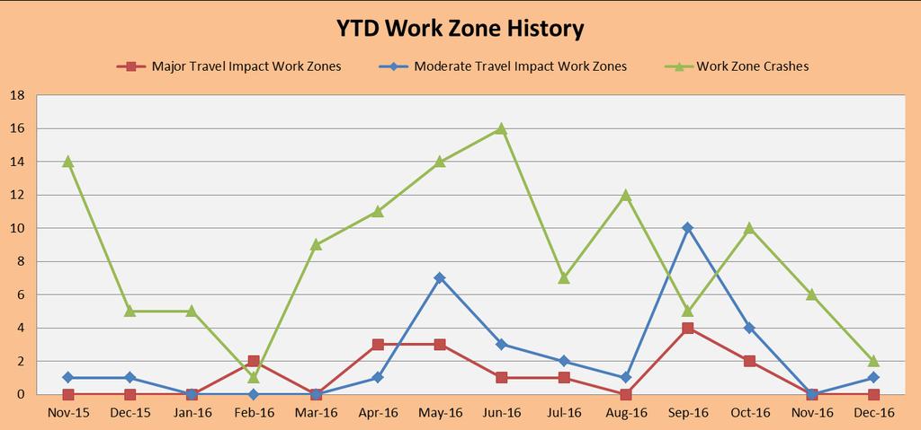
2 Work Zones TMC Observed Work Zones November - December 2016 November December Level of Travel Time Number of Work Level of Travel Number of Work Impact Zones Time Impact Zones Major Impact 0 Major Impact 0 Moderate Impact 0 Moderate Impact 1 Minor Impact 132 Minor Impact 125 Total 132 Total 126 *Impact Levels described in Data Key SL Mobility Rating: Nov 2016: 94% Dec 2016: 98% Goal: 91% SL Visibility levels: Nov 2016: 98% Dec 2016: 97% Goal: 91% Major Impact (15 Minutes or Above Additional Travel Time) ***None*** Moderate Impact (10-14 Minutes Additional Travel Time) 12/14 (Wednesday) Northbound I-170 at St. Charles Rock Road -- Center lane closed Center lane closure in place for 14 days All mitigation efforts were in use RITIS data recorded an additional travel time of 11 minutes during the AM and PM peaks Additional travel time determined from a baseline established with historical data for peak drive times Work Zone Related Crashes with Mobility Impact *****None***** 2

3 Work Zones 3


4 Incident Management 4


5 Incident Management November/December 2016 Incidents Map Westbound I-70 before 5 th Street Eastbound I-270 past West Florissant Ave. Eastbound I-270 at Chain of Rocks Bridge Southbound & Northbound I-270 at Page Ave. Westbound I-70 at Lucas & Hunt Rd. Westbound I-64 past Maryville Centre Dr. Eastbound I-44 past Lewis Rd. Eastbound I-44 at Lindbergh Blvd. Eastbound I-70 at O Fallon Park Eastbound I-44 at Lewis Rd. Southbound I-55 at Germania Ave. Westbound I-44 near MM Incidents Crashes Number of Incidents Southbound MO 141 past Centurion Dr. Northbound I-55 past Route Z Southbound I-270 ramp to Northbound I-55 Northbound I-55 past Imperial Main Denotes Location of Major Impact Traffic Incidents Total Number of Incidents: October: 803 / November: 871 / December: 799 Major Impact Incidents November 2016 vs. December 2016 (9) (7) Fatal Incidents November 2016 vs. December 2016 (8) (3) Tractor Trailer Incidents November 2016 vs. December 2016 (38) (48) 5

6 Incident Management Lane Blocking Incidents by Freeway November and December 2016 Interstate Month Number of Incidents Average Time to Clear Incident from Lanes = T4 - T1 Average Time for Backup to Clear = T6 - T4 Freeway Miles Incidents per Mile I-44 Nov :23 01: I-44 Dec 91 28:18 01: I-55 Nov :23 01: I-55 Dec 78 38:34 00: I-64 Nov :10 03: I-64 Dec :31 03: I-70 Nov :22 02: I-70 Dec :34 02: I-170 Nov 56 20:10 01: I-170 Dec 60 19:13 01: I-270 Nov :01 03: I-270 Dec :12 01: MO-364 Nov 23 12:36 01: MO-364 Dec 19 20:06 00: MO-370 Nov 15 12:20 01: MO-370 Dec 10 50:06 00: Total Nov/Dec :41 01:
7 Incident Management *Note changes in Incident reporting data began in July


8 Incident Management 2014 I-44 I-55 I-64 I-70 I-170 I-255 / I-270 Route 364 Route 370 Other * Total Jan Feb Mar Apr May Jun Jul Aug Sep Oct Nov Dec Totals *Other Routes are MoDOT maintained non-freeway routes and were not included on system until July


9 Incident Management 2015 I-44 I-55 I-64 I-70 I-170 I-255 / I-270 Route 364 Route 370 Other * Total Jan Feb Mar Apr May Jun Jul Aug Sep Oct Nov Dec Totals *Other Routes are MoDOT maintained non-freeway routes and were not included on system until July


10 Incident Management 2016 I-44 I-55 I-64 I-70 I-170 I-255 / I-270 Route 364 Route 370 Other Total Jan Feb Mar Apr May Jun Jul Aug Sep Oct Nov Dec Totals * *Other Routes are MoDOT maintained non-freeway routes and were not included on system until July


11 Incident Management November/December 2016 Tractor Trailer Incidents Map Number of Tractor Trailer Incidents Incidents Crashes January 2016 December 2016 Tractor Trailer Incidents Map Number of Tractor Trailer Incidents Incidents Crashes 11
 100% Incident")
12 Incident Management Major Impact Traffic Incidents and Mitigation 11/2/2016 (Wednesday) Time: 8:52 pm 12:11 am *** Fatality *** Location: St. Louis County Southbound MO 141 past Centurion Drive Event: Wrong-Way Driver / Multi-Vehicle Crash Estimated Initial Impact: Non-Rush Hour: 3 of 3 travel lanes affected equals (=) 100% Incident Details: A multi-vehicle crash, involving two motorcycles and a wrong-way passenger vehicle. The passenger vehicle was traveling northbound in the southbound lanes of MO 141. The vehicle struck both motorcycles head-on, resulting in the driver of one of the motorcycles to be fatally injured. The second motorcyclist was transported in serious condition. Action: St. Louis County Police, MSHP, Fenton Fire and EMS responded, as well as Emergency Response personnel who provided traffic control. Command of the scene was turned over to the MSHP who completed an accident reconstruction. This resulted in all lanes of Southbound MO 141 being closed. TMC activated all available DMS boards and the closure was entered into TMS to alert the public. No significant traffic impact was noted, presumably due to the time of day. Traffic immediately returned to normal once all lanes were cleared. Event Duration: 3 hours 19 minutes Southbound MO 141 past Centurion Drive Left Lane 1 Lane 2 Lane 3 Right Closed Hours/Minutes 3:19 3:19 3:14 3:11 3:11 12
13 Incident Management Major Impact Traffic Incidents and Mitigation 11/3/2016 (Thursday) Time: 5:25 am 8:58 am Location: St. Louis County Westbound I-70 at Lucas & Hunt Road Event: Multi-Vehicle Crash Estimated Initial Impact: Rush Hour: 3 of 3 travel lanes affected equals (=) 100% Incident Details: A three vehicle crash involving an SUV, passenger vehicle and a tractor trailer. It was reported that the SUV went under the tractor trailer rupturing a fuel tank and hydraulic fluid line. A secondary crash occurred in the queue approximately two hours into the incident and cleared at 8:27 am. Action: Normandy Police and Fire, and Christian Northeast EMS responded. Emergency Response personnel provided traffic control and assisted with detouring traffic around the crash using the Lucas & Hunt entrance ramp. ER units cleaned up the fuel and hydraulic fluid using oil dry. Duration was extended due to the complexity of removing the car out from under the tractor trailer. The TMC messaged for the event using all available DMS boards and the closure was entered into TMS to alert the public. The EOC and Communication Staff were both notified of the incident. Traffic queued for 6 miles back to Grand Avenue and took approximately 27 minutes after all lanes were cleared to return to normal. Event Duration: 3 hours 33 minutes Westbound I-70 at Lucas & Hunt Road Left Lane 1 Lane 2 Lane 3 Entrance Lane 1 Right Closed Hours/Minutes 3:33 3:33 3:33 2:26 0:00 0:00 13
 100% Incident Details: A passenger vehicle struck the")

14 Incident Management Major Impact Traffic Incidents and Mitigation 11/6/2016 (Sunday) Time: 1:21 am 6:51 am *** Fatality *** Location: St. Louis City Eastbound I-70 at O Fallon Park Event: Vehicle Crash Estimated Initial Impact: Non-Rush Hour: 3 of 3 travel lanes affected equals (=) 100% Incident Details: A passenger vehicle struck the rear of small SUV causing it to strike the median wall. Two of the occupants of the SUV were ejected and a total of four from that vehicle were transported with serious to critical injuries. One was later pronounced deceased at the hospital. The driver of the passenger car got into a second vehicle that stopped and fled the scene. Action: St. Louis City Police, Fire and EMS responded, and Emergency Response personnel provided traffic control. All lanes of the interstate were closed as police completed a reconstruction. Drivers were detoured off at Exit 246 (O Fallon Park) where they were able reenter the interstate on the other side of the overpass. The EOC, Communications Staff, IDOT, Motor Carriers, the AE, and the MoDOT Incident Management Coordinator were notified. The TMC messaged for the event and entered it into TMS to notify the public. Traffic queued approximately a half mile to West Florissant Avenue at the onset, but quickly cleared once the detour was in place. Event Duration: 6 hours 30 minutes (includes additional hour from Daylight Savings time change) Eastbound I-70 at O Fallon Park Left Lane 1 Lane 2 Lane 3 Right Closed Hours/Minutes 6:30 6:30 6:30 6:30 6:30 14
15 Incident Management Major Impact Traffic Incidents and Mitigation 11/8/2016 (Tuesday) Time: 2:39 am 11:32 am Location: St. Louis County Eastbound I-44 at Lewis Road Event: Single Vehicle Crash Estimated Initial Impact: Rush Hour: 3 of 3 travel lanes affected equals (=) 100% Incident Details: Overturned tractor trailer carrying 77,000 pounds of vegetables. The produce had to be off loaded by hand before the trailer could be up righted. Action: St. Louis County Police, Eureka Fire and EMS responded. Emergency Response personnel provided traffic control. There were concerns that the trailer may fall apart if they attempted to lift it. Air bag system equipment was requested, which increased the duration of the incident. The EOC, Motor Carriers, IDOT, and the MoDOT Incident Management Coordinator were notified. The TMC messaged for the event and entered it into TMS to notify the public. Event Duration: 8 hours 52 minutes Eastbound I-44 at Lewis Road Left Lane 1 Lane 2 Lane 3 Right Closed Hours/Minutes 4:04 4:08 4:27 5:56 8:43 15
 100% Incident Details: A tractor trailer ran off")


16 Incident Management Major Impact Traffic Incidents and Mitigation 11/9/2016 (Wednesday) Time: 3:17 am 6:43 am Location: St. Louis County Eastbound I-44 past Lewis Road Event: Vehicle Crash Estimated Initial Impact: Rush Hour: 3 of 3 travel lanes affected equals (=) 100% Incident Details: A tractor trailer ran off the right side of the road, struck the guardrail before returning to the roadway where it overturned. Action: St. Louis County Police, MSHP, and Eureka Fire and EMS responded. Emergency Response personnel assisted with traffic control. Duration of the incident was extended due to the fact that the tractor trailer s cargo had to be offloaded before the trailer could be up righted. All lanes of traffic were closed during this process and traffic was diverted off onto Lewis Road. The TMC messaged for the incident and notified the MoDOT Incident Management Coordinator, EOC, motor carriers, the AE, and community relations. Traffic took 47 minutes to return to normal once both crashes were cleared. Event Duration: 3 hour 26 minutes Eastbound I-44 past Lewis Left Lane 1 Lane 2 Lane 3 Right Closed Hours/Minutes 3:08 3:08 3:08 3:08 3:08 16
 100% Incident Details: A MoDOT Emergency Response")

17 Incident Management Major Impact Traffic Incidents and Mitigation 11/9/2016 (Wednesday) Time: 5:41 pm 8:31 pm *** Fatality *** Location: St. Louis City Southbound I-55 at Germania Avenue Event: Police Activity Estimated Initial Impact: Rush Hour: 4 of 4 travel lanes affected equals (=) 100% Incident Details: A MoDOT Emergency Response unit came across what he believed to be a stalled vehicle on the right shoulder of Southbound I-55 just past Loughborough. He attempted to contact the driver to see if he needed assistance. It was discovered that the driver had been shot and was deceased. The TMC notified St. Louis City PD and the MoDOT ER unit remained on scene attempting to secure it until police arrived. Action: MoDOT Emergency Response began blocking Lane 4 prior to St. Louis City PD s arrival. Once St. Louis City PD arrived, they took Lane 3 and eventually closed all lanes to complete a sweep of the area with K9 units. The EOC, IDOT, AE, Communication Staff, Motor Carriers, and the MoDOT Incident Management Coordinator were all notified. The TMC messaged for the event and entered it into TMS to notify the public of the closure. Traffic was diverted off at Bates, where they could return to the interstate via Carondelet Boulevard. Traffic queued approximately 1.6 miles, but returned to normal almost immediately after the lanes were opened. Event Duration: 2 hours 50 minutes Southbound I-55 at Germania Avenue Left Lane 1 Lane 2 Lane 3 Lane 4 Right Closed Hours/Minutes 1:39 1:39 1:39 2:10 2:35 2:50 17
18 Incident Management Major Impact Traffic Incidents and Mitigation 11/19/2016 (Saturday) Time: 12:30 pm 4:44 pm Location: St. Louis County Southbound & Northbound I-270 at Page Avenue Event: Police Pursuit / Vehicle Crash Estimated Initial Impact: Non-Rush Hour: 8 of 8 travel lanes affected equals (=) 100% Incident Details: A police pursuit of a carjacking suspect from Wentzville, MO. After running over stop sticks, the vehicle crashed into the median wall of Southbound I-270 at Page Avenue. As officers approached the vehicle shots were fired. This resulted in an entire closure of Southbound and Northbound I-270. Action: Due to the nature of the incident, police units from numerous jurisdictions responded to assist. MoDOT Emergency Response provided traffic control detouring drivers off at Page Avenue and eventually moving the detour back to Dorsett Road. The TMC messaged for the closure on all available DMS boards and it was also entered into TMS to alert the public. The EOC, IDOT, AE, Community Relations, Motor Carriers, and the MoDOT Incident Management Coordinator were all notified. The initial queue was back to Dorsett Road in the southbound direction. However, the queue cleared quickly once the detour was in place. Due primarily to the time of the incident, the impact to traffic was minimal and no noticeable queue was observed on the northbound side. Event Duration: 4 hours 14 minutes Southbound I-270 at Page Avenue Left Lane 1 Lane 2 Lane 3 Lane 4 Right Closed Hours/Minutes 4:12 4:12 4:12 4:06 4:03 4:03 Northbound I-270 at Page Avenue Left Lane 1 Lane 2 Lane 3 Lane 4 Right Closed Hours/Minutes 2:16 2:16 2:16 2:16 2:16 2:16 18


19 Incident Management Major Impact Traffic Incidents and Mitigation 19
 100% Incident Details: Vehicle 1 was following too close to Vehicle 2 and lost control when")

20 Incident Management Major Impact Traffic Incidents and Mitigation 11/25/2016 (Friday) Time: 8:52 pm 12:34 am *** Fatality *** Location: Jefferson County Northbound I-55 past Route Z Event: Multi-Vehicle Crash Estimated Initial Impact: Non-Rush Hour: 3 of 3 travel lanes affected equals (=) 100% Incident Details: Vehicle 1 was following too close to Vehicle 2 and lost control when applying brakes. Vehicle 1 ran off the left side of the roadway where it struck the center median cables. This caused Vehicle 1 to overturn and come to rest on its passenger side in the left lane. A third vehicle traveling north struck the overturned vehicle, which resulted in the driver of the overturned vehicle to be fatally injured. Action: MSHP, Jefferson County Sheriff, Fire and EMS responded. MoDOT Emergency Response provided traffic control. All northbound lanes of the highway were closed as the Air Evac helicopter landed on the interstate to transport the driver of Vehicle 1. The highway remained closed for MSHP to complete reconstruction. Duration of the incident was extended 40 minutes for the reconstructionist to arrive on scene. Traffic was diverted off at Route Z. The TMC messaged for the event and it was entered into TMS to alert the public. The traffic queue was approximately ¼ of a mile. Event Duration: 3 hours 41 minutes Northbound I-55 Past Route Z Left Lane 1 Lane 2 Lane 3 Right Closed Hours/Minutes 2:14 3:41 3:39 1:15 0:54 20
 100% Incident Details: A vehicle left the St.")

21 Incident Management Major Impact Traffic Incidents and Mitigation 11/27/2016 (Sunday) Time: 4:02 am 7:29 am *** 3 Fatalities *** Location: Franklin County Westbound I-44 near Mile Marker Event: Wrong-Way Driver Vehicle Crash Estimated Initial Impact: Non-Rush Hour: 2 of 2 travel lanes affected equals (=) 100% Incident Details: A vehicle left the St. Clair Rest Area traveling eastbound in the westbound lanes of I-44. That vehicle struck a minivan head on, which was occupied by seven passengers. The drivers of both vehicles and a two-year-old passenger in the minivan were all pronounced at the scene. The remaining five passengers of the minivan were transported with injuries ranging from minor to serious. Action: MSHP, Franklin County, and St. Clair Fire and EMS responded. The scene was turned over to the MSHP who completed an accident reconstruction. MoDOT Emergency Response assisted with diverting traffic to the outer road at St. Clair Exit 239. The TMC messaged for the incident on all available DMS boards and entered the closure into TMS to alert the public. The EOC, Motor Carriers, Community Relations, and the AE were all notified. Traffic queued an estimated 3 miles, prior to the detour being put into place, and cleared quickly thereafter. Event Duration: 3 hours 26 minutes Westbound I-44 Near Mile Marker Left Lane 1 Lane 2 Right Closed Hours/Minutes 3:26 3:26 3:26 3:26 21
22 Incident Management Major Impact Traffic Incidents and Mitigation 12/5/2016 (Monday) Time: 5:00 pm 7:25 pm Location: St. Louis County Southbound I-270 ramp to Northbound I-55 Event: Single Vehicle Crash Estimated Initial Impact: Rush Hour: 1 of 1 ramp lane affected equals (=) 100% Incident Details: A car hauler overturned while hauling one vehicle, blocking the ramp. Action: Emergency Response personnel provided traffic control. St. Louis County Police, along with Mehlville Fire and EMS responded. The duration of the incident was extended due to the fact that three large tow trucks were required to upright the car hauler and the vehicle it was hauling. The TMC messaged alerting drivers of the incident. EOC, motor carriers, AE, and Communication Staff were notified. A queue of approximately one mile was observed, just south of Gravois Road, primarily in the right lanes. Event Duration: 2 hours 25 minutes Southbound I-270 ramp to Northbound I-55 Left Exit Lane Right Closed Hours/Minutes 2:25 2:25 2:25 12/5/2016 (Monday) Time: 5:24 pm 6:54 pm Location: St. Louis County Eastbound I-44 at Lindbergh Boulevard Event: School Bus Fire Estimated Initial Impact: Rush Hour: 5 of 5 travel lanes affected equals (=) 100% Incident Details: A school bus driver noticed smoke coming from the engine as he was driving. The bus driver immediately pulled the bus over to the shoulder and took steps to evacuate all students before the fire engulfed the bus. Two students were transported. One student for an injured ankle and a second for complaints of smoke inhalation. Action: MSHP, St. Louis County Police, Crestwood Police, Fire and Abbot EMS responded. Emergency Response personnel assisted with traffic control. TMC activated all available DMS boards and the incident was entered into TMS to alert the public. Duration of incident was extended due to the amount of oil and debris on the roadway. MoDOT ER units used several bags of oil dry in the cleanup. Traffic queued approximately 1.5 miles to Watson Road. Event Duration: 1 hours 30 minutes 22


23 Incident Management Major Impact Traffic Incidents and Mitigation Eastbound I-44 at Lindbergh Boulevard Left Lane 1 Lane 2 Lane 3 Lane 4 Lane 5 Right Closed Hours/Minutes 0:25 0:25 0:25 0:53 1:28 1:28 1:28 23
24 Incident Management Major Impact Traffic Incidents and Mitigation 12/9/2016 (Friday) Time: 8:10 pm 10:46 pm Location: St. Louis County Eastbound I-270 past West Florissant Avenue Event: Multi-vehicle Crash Estimated Initial Impact: Non-Rush Hour: 4 of 4 travel lanes affected equals (=) 100% Incident Details: A chain reaction crash that occurred after Vehicle 1, travelling at a high rate of speed, struck the rear of Vehicle 2. Vehicle 2 struck Vehicle 3 and travelled off the left side of the roadway. Vehicle 2 then struck the median wall before travelling off the right side of the roadway and overturning. Vehicle 3 travelled off the right side of the road and struck a fence. Vehicle 1 continued and struck Vehicle 4 before travelling off the left side of the road and striking the concrete median. Vehicle 4 spun around and struck overturned Vehicle 2. Action: St. Louis County Police, MSHP, Ferguson Fire and Christian NE EMS responded. Emergency Response personnel assisted with traffic control. TMC activated all available DMS boards and the incident was entered into TMS to alert the public. Traffic queued for two miles for a short time when all lanes were closed. However, it cleared quickly once lane #2 was opened and there was no further significant impact to traffic noted. Event Duration: 2 hours 36 minutes Eastbound I-270 past West Florissant Avenue Left Lane 1 Lane 2 Lane 3 Exit Lane 1 Right Closed Hours/Minutes 0:00 2:16 0:23 2:30 2:30 2:36 24
 50% Incident Details: Multiple vehicle")
25 Incident Management Major Impact Traffic Incidents and Mitigation 12/16/2016 (Friday) Time: 4:56 pm 9:03 pm *** Weather Related *** Location: St. Louis County Westbound I-64 past Maryville Centre Drive Event: Multi-vehicle Crash Estimated Initial Impact: Rush Hour: 2 of 4 travel lanes affected equals (=) 50% Incident Details: Multiple vehicle crashes along the same stretch of roadway due to ice. Action: Maintenance crews responded to salt the area. Event Duration: 4 hours 7 minutes Westbound I-64 past Maryville Centre Drive Left Lane 1 Lane 2 Lane 3 Lane 4 Right Closed Hours/Minutes 0:00 0:00 0:00 4:07 4:07 4:07 12/16/2016 (Friday) Time: 6:19 pm 12:30 am *** Weather Related *** Location: Jefferson County Northbound I-55 past Imperial Main Event: Multi-vehicle Crash Estimated Initial Impact: Rush Hour: 4 of 4 travel lanes affected equals (=) 100% Incident Details: Initially a multi-vehicle crash. Then, due to ice, tractor trailers were not able to get up the hill and emergency responders were not able to get on scene to assist. Action: Maintenance, assisted by MSHP, came southbound in the northbound lane to spread salt at the front of the queue. Road treatment allowed traffic to slowly start moving. The TMC messaged for the event on all available message boards. The EOC, motor carriers, and Communications Staff were notified. Queue was estimated at 4 miles. Event Duration: 6 hours 11 minutes Northbound I-55 past Imperial Main Left Lane 1 Lane 2 Lane 3 Lane 4 Right Closed Hours/Minutes 5:32 5:32 5:32 5:49 6:11 6:11 25
26 Incident Management Major Impact Traffic Incidents and Mitigation 12/19/2016 (Monday) Time: 3:54 am 9:27 am Location: St. Charles County Westbound I-70 before 5 th Street Event: Multi-vehicle Crash Estimated Initial Impact: Rush Hour: 2 of 4 travel lanes affected equals (=) 50% Incident Details: A three vehicle crash including two tractor trailers. One of the tractor trailers was hauling soda, which apparently exploded during the crash. This caused the soda to spill onto the roadway. Action: St. Charles City Police, Fire and EMS responded. Emergency Response personnel assisted with traffic control. The incident was extended due to several maintenance trucks needed to assist with the cleanup. The TMC messaged for the incident. The initial queue was minimal with traffic backing up only to the Blanchette Bridge. During rush hour traffic was slow through the area (primarily due to on-lookers). Event Duration: 5 hours 33 minutes Westbound I-70 before 5 th Street Left Lane 1 Lane 2 Lane 3 Lane 4 Right Closed Hours/Minutes 0:00 0:00 0:00 0:09 5:17 5:17 26
 66% Incident Details: A tractor")

27 Incident Management Major Impact Traffic Incidents and Mitigation 12/28/2016 (Wednesday) Time: 5:58 am 8:08 am Location: St. Louis City/Illinois Eastbound I-270 at Chain of Rocks Bridge Event: Single Vehicle Crash Estimated Initial Impact: Rush Hour: 2 of 3 travel lanes affected equals (=) 66% Incident Details: A tractor trailer crashed into the guardrail of Westbound I-270 on the Chain of Rocks Bridge. The cab of the tractor trailer went over the side of the bridge and became fully engulfed in fire. Firefighters fought the blaze from both sides of the bridge, which burned consistently for over an hour. Action: St. Louis City Fire and EMS, Illinois Fire Departments, Illinois State Police, St. Louis City Police, and St. Louis County Police responded. Initially only westbound traffic coming from Illinois was affected. However, once firefighters arrived, both eastbound and westbound lanes of I-270 were closed. Emergency Response personnel assisted St. Louis County Police with shutting the eastbound lanes of traffic at MO 367. Ramp access to Eastbound I-270 also had to be shut down at Bellefontaine Road, Lilac and Riverview Blvd. The signal engineer set the signals to favor exiting traffic. The incident was extended due to the length of time it took to get the fire extinguished, cleanup of the area, and the bridge had to be inspected by an engineer to ensure no structural damage. The TMC messaged for the closure advising motorist to seek an alternative route and also entered it into TMS to notify the public. The EOC, AE, Motor Carriers, and MoDOT Incident Management Coordinator were all notified. The initial queue was 2.5 miles (back to Lilac) prior to the diversion at MO 367. After the initial queue, impact to traffic was minimal. Event Duration: 2 hours 9 minutes Eastbound I-270 at Chain of Rocks Bridge Lane 1 Lane 2 Lane 3 Right Closed Hours/Minutes 1:22 1:09 1:09 1:09 27

28 Incident Management Major Impact Traffic Incidents and Mitigation 28


29 Incident Management Major Impact Traffic Incidents and Mitigation 29


30 Freeway Management I G A H B E C D F AM Peak Mobility Snapshot November 2016 E High Mobility A B C G H Medium Mobility D F I Low Mobility *All weekdays are included in speed index 30

31 Freeway Management I G A E H B C D F AM Peak Mobility Snapshot December 2016 E G High Mobility A B C H Medium Mobility D F I Low Mobility *All weekdays are included in speed index calculation 31

32 Freeway Management B C E D 32
33 Freeway Management F 33

34 Freeway Management F 34
35 Freeway Management G H 35

36 Freeway Management I 36
37 Freeway Management (This page intentionally left blank) 37
38 Freeway Management O N L E P M J I A H A F K G C B D I J PM Peak Snapshot November 2016 High Mobility B C E F N O Medium Mobility A D G H K L M P Low Mobility *All weekdays are included in speed index 38
39 Freeway Management O P N L E J M I A H A F K G C B D D I PM Peak Snapshot December 2016 High Mobility B C E F G J M N O Medium Mobility A H K L P Low Mobility *All weekdays are included in speed index 39

40 Freeway Management 40
41 Freeway Management D E F G 41
42 Freeway Management H I J 42
43 Freeway Management K 43

44 Freeway Management K 44

45 Freeway Management L 45
46 Freeway Management L 46
47 Freeway Management M N O P 47

48 Freeway Management 48
49 Freeway Management Nov 2016 EB MO River Crossings Total = 201, November 2016 EB I-64 EB I-70 EB MO 364 EB MO Dec 2016 EB MO River Crossings Total = 197,589 December 2016 EB I-64 EB I-70 EB MO 364 EB MO
50 Freeway Management Nov 2016 WB MO River Crossings Total = 193,478 November 2016 WB I-64 WB I-70 WB MO 364 WB MO Dec 2016 WB MO River Crossings Total = 187,571 December 2016 WB I-64 WB I-70 WB MO 364 WB MO
51 Freeway Management Nov 2016 EB MS River Crossings Total = 121, November 2016 EB PSB EB I-70 EB I-255 EB I Dec 2016 EB MS River Crossings Total = 121,337 December 2016 EB PSB EB I-70 EB I-255 EB I
52 Freeway Management Nov 2016 WB MS River Crossings Total = 147, November 2016 WB PSB WB I-70 WB I-255 WB I Dec 2016 WB MS River Crossings Total = 140,573 December 2016 WB PSB WB I-70 WB I-255 WB I

53 Arterial Management No arterial data available. 53
54 Data Key Work Zones Whenever additional travel time is reported, this additional time shall be evaluated using this chart and adequate mitigation measures should begin within the parameters of this chart. TMC and field personnel are partners in the mitigation of traffic and notification of additional travel times should trigger the appropriate response from both parties. Chart is designed to be an additional travel time reference to establish parameters for gauging the travel impact through work zones and to provide guidance for taking mitigation actions. Travel times can be collected or reported via Blue Toad technology, field personnel, call reports, ITS, TMC cameras, etc. Major and Moderate impacts trigger an IAR (Immediate Action Required) event. IAR means work zone user and TMC partner together to take immediate actions to reduce or eliminate distress. During an IAR event mitigation procedures can range from increased driver notification up to and including removal of work zone. Additional mitigation procedures may require involvement of administration through use of the work zone resolution ladder. Level of Impact Major (Red) IAR Event SEVERE DISTRESS PRESENT Return of roadway to free flow traffic is Priority #1 Moderate (Yellow) IAR Event CAUTIONARY STAGE: Action required by Field/ TMC to prevent escalation to a major event Additional Travel Time Expected 15 minutes or above TMC and field personnel take all steps possible up to and including removal of lane closure to achieve free flow threshold minutes TMC increases driver messaging. Field begins efforts to restore free flow traffic Mitigation Actions Immediate Action Required Supervisory mitigation assistance is required using the St. Louis District Work Zone Resolution Ladder as a tool to restore free flow traffic threshold TMC and field shall reach a consensus on mitigation success within 15 minutes or less. If a consensus cannot be reached, mitigation should be scaled upwards in accordance with the St. Louis District Work Zone Resolution Ladder 54


55 Data Key Incident Levels Major Impact Traffic Incident Road closure > 2 hours Major traffic incidents are typically traffic incidents involving hazardous materials, fatal traffic crashes involving numerous vehicles, and other natural or man-made disasters. These traffic incidents typically involve closing all or part of a roadway facility for a period exceeding 2 hours. Moderate Impact Traffic Incident Blocked travel lanes/closure 30 min 2 hours Moderate traffic impact incidents typically affect travel lanes for a time period of 30 minutes to 2 hours, and usually require traffic control on the scene to divert road users past the blockage. Full roadway closures might be needed for short periods during traffic incident clearance to allow traffic incident responders to accomplish their tasks. Minor Impact Traffic Incident Lane closures < 30 minutes Minor traffic incidents are typically disabled vehicles and minor crashes that result in lane closures of less than 30 minutes. On-scene responders are typically law enforcement and towing companies, and occasionally highway agency service patrol vehicles. Worst Time to Travel Clocks - The clocks found on the speed charts depict the progression of travel speeds during the commute peak period at the worst congestion location along the route. - For example, the clock on the left depicts conditions worsening at a particular location beginning at 6:30 a.m. with the slowest speeds between 7 a.m. and 8:15 a.m. Conditions improved at 8:45 a.m. The focus area for calculating the average 24 hour volumes was revisited in 2015 and consolidated to the more urban interstates of the St. Louis District. For example, data is generated from detectors on I-44 east of MO 141 (previously included all available in the District). 55
56 Data Key Definitions ACTRA Traffic signal management software program Alert message sent regarding an incident or event on the roadway Arterial Missouri State Highway Numbered Routes, not fully access controlled Arterial Device ITS equipment located along MoDOT arterials Defined Sensor A single sensor with an individual ID focused on a particular roadway; multiple defined sensors may be located at one physical sensor location DMS Dynamic Message Signs along highway displaying incident and travel time information DNR Department of Natural Resources Driver messaging Messages placed on DMS boards to alert drivers of incidents ahead of their direction of travel EOC Emergency Operations Center operated by MoDOT in Jefferson City EMS Emergency Medical Services ER MoDOT s Emergency Response units that provide emergency assistance, incident management and traffic control to mitigate incidents and restore free flow traffic within the St. Louis region Freeway Device ITS device located along a MoDOT freeway, such as interstates and other fully access controlled highways Gatewayguide.com Gateway Guide s website for local St. Louis area traffic information GGL Gateway Green Light is the St. Charles County regional integrated corridor management for a cooperative multi-jurisdictional effort to better manage and coordinate travel on the interstates (I-70, I- 64), state routes (MO 94, MO 364, MO 370, US 61) and local arterials through the installation of Intelligent Transportation Systems (ITS) in Cottleville, Dardenne Prairie, Lake St. Louis, O Fallon, St. Charles, St. Peters, and Wentzville. GuidePost Area of report highlighting important mobility topics for the month IDOT Illinois Department of Transportation KC Scout Gateway Guide s counterpart for the greater Kansas City Metropolitan area, a collaboration involving both MoDOT and the Kansas DOT Mobility Ease of movement over roadway, through system, and or work zone MRB Mississippi River Bridge under construction north of downtown St. Louis MSHP Missouri State Highway Patrol Observed Work zone Work zone tracked by traffic cameras at the TMC 56
57 Data Key Peak Average Daily speed sensor readings over an entire weekday average commute period averaged for an entire month PSB Poplar Street Bridge Regional Mobility Overview Map depicting congestion areas based on speed index ratings derived from speed sensor readings SL Designation for the St. Louis District Speed Index a ratio of the speed at which vehicles travel during a period to the speed at free-flow conditions Stats to Watch Area of report highlighting interesting trends for the report month, or data to be closely followed STLtraffic group consisting of Gateway Guide personnel and Gateway Guide s media partners, messages sent to the group are also posted on Twitter TMC Traffic Management Center (also referred to as Gateway Guide) TMC Alert alert sent to an internal group of Gateway Guide personnel TMS Traveler Map System is MoDOT s internal software for entering work zones and road conditions to populate the Traveler Information Map at Travel Time Index A ratio of the actual time to travel a corridor compared to travel time at posted speed limit without stops used User Delay Costs Puts a dollar amount on how much a road's performance impacts its users. Combines probe speed data with volume data provided by the Texas Transportation Institute to estimate the cost of delay experienced by drivers as a result of congestion. Vehicle costs used are Passenger Vehicle = $17.67 and Commercial Vehicle = $ Visibility Concerning placement of traffic signs, signals, devices, barricades and warning lights for safety within work zone or construction area to help motorist and workers move within a work zone safely; Clearly visible and legible, distinguishable to approaching traffic during day and night, aligned with road user s line of vision, and positioned as to not obstruct other applicable traffic control devices. Must meet MUTCD standards for condition and must be covered, turned or properly stowed when not in use. Zoning In section of report highlighting important construction topics for the report month 57
58 Data Key I-70 Mile Markers ST. CHARLES COUNTY 5TH ST SOUTH (ST. CHARLES) 229A 5TH ST NORTH (ST. CHARLES) 229B ST. LOUIS COUNTY BLANCHETTE BRIDGE 230 EARTH CITY EXPRESSWAY SOUTH 231A EARTH CITY EXPRESSWAY NORTH 231B I MCKELVEY RD OVERPASS (BRIDGETON) 233 RTE 180/ST. CHARLES ROCK RD (BRIDGETON 234 US 67 SOUTH (BRIDGETON) US 67 NORTH (BRIDGETON) CYPRESS RD (BRIDGETON) AIRFLIGHT (ST. ANN) MCDONNELL OVERPASS (BERKELEY) LAMBERT AIRPORT (BERKELEY) I-170 NORTH (BERKELEY) I-170 SOUTH (BERKELEY) NORTH HANLEY (BERKELEY) RTE N/FLORISSANT RD (COOL VALLEY) BERMUDA DR (NORMANDY) RTE U/LUCAS AND HUNT RD JENNINGS STATION RD (PINE LAWN) ST. LOUIS CITY GOODFELLOW (ST. LOUIS) RIVERVIEW/BIRCHER (ST. LOUIS) UNION (ST. LOUIS) KINGSHIGHWAY (ST. LOUIS) SHREVE (ST. LOUIS) WEST FLORISSANT AVE (ST LOUIS) NORTH BROADWAY (ST. LOUIS) ADELAIDE (ST LOUIS) GRAND (ST. LOUIS) SALISBURY (ST LOUIS) BRANCH (ST LOUIS) MADISON (ST LOUIS) PINE ST OVERPASS (ST LOUIS) CHESTNUT ST OVERPASS (ST LOUIS) MARKET ST OVERPASS (ST. LOUIS) WALNUT ST OVERPASS (ST LOUIS) 235A 235B 235C A 238B 238C A 240B 241B 242C 243A 243B 244A 244B 245A 245B 246A 246B A 248B 249A I-70 DISTRICT 6 WESTBOUND I-70 DISTRICT 6 EASTBOUND 229A 229B A 231B A 235B 235C A 238B 238C A 240B 241B 242C 243A 243B 244A 244B 245A 245B 246A 246B A 248B 249A ST. CHARLES COUNTY 5TH ST SOUTH (ST. CHARLES) 5TH ST NORTH (ST. CHARLES) ST. LOUIS COUNTY BLANCHETTE BRIDGE EARTH CITY EXPRESSWAY SOUTH EARTH CITY EXPRESSWAY NORTH I-270 MCKELVEY RD OVERPASS (BRIDGETON) RTE 180/ST. CHARLES ROCK RD (BRIDGETON US 67 SOUTH (BRIDGETON) US 67 NORTH (BRIDGETON) CYPRESS RD (BRIDGETON) AIRFLIGHT (ST. ANN) MCDONNELL OVERPASS (BERKELEY) LAMBERT AIRPORT (BERKELEY) I-170 NORTH (BERKELEY) I-170 SOUTH (BERKELEY) NORTH HANLEY (BERKELEY) RTE N/FLORISSANT RD (COOL VALLEY) BERMUDA DR (NORMANDY) RTE U/LUCAS AND HUNT RD JENNINGS STATION RD (PINE LAWN) ST. LOUIS CITY GOODFELLOW (ST. LOUIS) RIVERVIEW/BIRCHER (ST. LOUIS) UNION (ST. LOUIS) KINGSHIGHWAY (ST. LOUIS) SHREVE (ST. LOUIS) WEST FLORISSANT AVE (ST LOUIS) NORTH BROADWAY (ST. LOUIS) ADELAIDE (ST LOUIS) GRAND (ST. LOUIS) SALISBURY (ST LOUIS) BRANCH (ST LOUIS) MADISON (ST LOUIS) PINE ST OVERPASS (ST LOUIS) CHESTNUT ST OVERPASS (ST LOUIS) MARKET ST OVERPASS (ST. LOUIS) WALNUT ST OVERPASS (ST LOUIS) 58
59 Data Key I-70 St. Charles County Mile Markers RTE A (WENTZVILLE) RTE A (WENTZVILLE) LAKE ST. LOUIS BLVD (LAKE ST. LOUIS) LAKE ST. LOUIS BLVD (LAKE ST. LOUIS) BRYAN RD (O'FALLON) BRYAN RD (O'FALLON) RTE K/RTE M (O'FALLON) T.R. HUGHES BLVD (O'FALLON) RTE 79 (ST. PETERS/O'FALLON) RTE C/MID RIVERS MALL DR (ST. PETERS) SPENCER RD OVERPASS (ST. PETERS) RTE 370 (ST. PETERS) CAVE SPRINGS (ST. CHARLES) ZUMBEHL RD (ST. CHARLES) HAWK'S NEST OVERPASS (ST. CHARLES) RTE 94 (ST. CHARLES) I-70 DISTRICT 6 EASTBOUND I-70 DISTRICT 6 WESTBOUND RTE K/RTE M (O'FALLON) T.R. HUGHES BLVD (O'FALLON) RTE 79 (ST. PETERS/O'FALLON) RTE C/MID RIVERS MALL DR (ST. PETERS) SPENCER RD OVERPASS (ST. PETERS) RTE 370 (ST. PETERS) CAVE SPRINGS (ST. CHARLES) ZUMBEHL RD (ST. CHARLES) HAWK'S NEST OVERPASS (ST. CHARLES) RTE 94 (ST. CHARLES) 5TH ST SOUTH (ST. CHARLES) 229A 229A 5TH ST SOUTH (ST. CHARLES) 5TH ST NORTH (ST. CHARLES) 229B 229B 5TH ST NORTH (ST. CHARLES) 59
60 Data Key I-270 Mile Markers 3 2 1C 1B C A 25B A 31B KOCH RD SR 231 (TELEGRAPH RD) US61-67 I-55 NORTH I-55 SOUTH SR 21 (TESSON FERRY RD.) SR 30 (GRAVOIS RD.) I-44 EAST/SR 366 (WATSON RD.) I-44 WEST DOUGHERTY FERRY RD. SR 100 (MANCHESTER RD.) I-64 EAST/WEST/US NORTH/SOUTH SR AB (LADUE RD) SR 340 (OLIVE BLVD) SR D (PAGE AVE.) EAST SR 364 WEST DORSETT RD I-70 WEST/EAST SR 180 (ST. CHARLES ROCK RD) MISSOURI BOTTOM RD/370 WEST MCDONNELL BLVD US 67 SOUTH US 67 NORTH HANLEY/GRAHAM RD. I-170 SOUTH NEW FLORISSANT RD WASHINGTON/ELIZABETH RD. WEST FLORISSANT RD SR AC HALLS FERRY RD SR 367 SOUTH SR 367 NORTH BELLEFONTAINE RD LILAC AVE. RIVERVIEW DR. I-255 WESTBOUND --- > I-270 DISTRICT 6 CLOCKWISE FROM I-55 TO RIVERVIEW DR. --- > I-255 EASTBOUND <--- I-270 DISTRICT 6 COUNTER CLOCKWISE FROM RIVERVIEW DR. TO I-55 <--- KOCH RD SR 231 (TELEGRAPH RD) US61-67 I-55 NORTH I-55 SOUTH SR 21 (TESSON FERRY RD.) SR 30 (GRAVOIS RD.) I-44 EAST I-44 WEST BIG BEND RD. DOUGHERTY FERRY RD. SR 100 (MANCHESTER RD.) I-64 EAST/WEST/US NORTH/SOUTH SR AB (LADUE RD) SR 340 (OLIVE BLVD) SR D (PAGE AVE.) EAST SR 364 WEST DORSETT RD I-70 WEST I-70 EAST SR 180 (ST. CHARLES ROCK RD) SR 370 WEST MCDONNELL BLVD US 67 NORTH US 67 SOUTH I-170 SOUTH (EXIT LEFT) HANLEY/GRAHAM NEW FLORISSANT RD ELIZABETH/WASHINGTON WEST FLORISSANT RD SR AC NEW HALLS FERRY RD NEW HALLS FERRY RD. SR 367 SOUTH SR 367 NORTH BELLEFONTAINE RD LILAC AVE. RIVERVIEW DR B 1B 1A A/B A 16B 17 20B 20A 20C 22D 23 25A 25B 26A 26B A 31A 31B
61 Data Key I-64 Mile Markers I-70 WEST EXIT RIGHT/EAST EXIT LEFT 1 1A I-70 WEST 1B I-70 EAST PROSPECT RD 1C 1C PROSPECT RD LAKE ST. LOUIS BLVD 2 2 LAKE ST. LOUIS BLVD SR N 4 4 MO N SR DD/WINGHAVEN 6 6 MO DD/Winghaven SR K/SR MO K 10 MO 94 MISSOURI RESEARCH PARK/TECHNOLOGY DR RESEARCH PARK CRL DANIEL BOONE BRIDGE DANIEL BOONE BRIDGE CHESTERFIELD AIRPORT RD SPIRIT OF ST LOUIS BLVD 16 LONG RD BOONE S CROSSING BOONE S CROSSING CHESTERFIELD PKWY 19A 19A CHESTERFIELD PKWY SR 340 (OLIVE/CLARKSON 19B 19B MO 340 (OLIVE/CLARKSON) 20 CHESTERFIELD PKWY TIMBERLAKE MANOR PKWY TIMBERLAKE MANOR PKWY SR MO 141 (WOODS MILL RD) MASON RD I-270 SOUTH I-270 NORTH SR JJ (BALLAS RD) SPOEDE RD US A 25B A I-64 DISTRICT 6 WESTBOUND I-64 DISTRICT 6 EASTBOUND A 25B A MARYVILLE CENTRE DR MASON RD I-270 SOUTH I-270 NORTH MO JJ (BALLAS RD) SPOEDE RD US B CLAYTON RD MCKNIGHT RD MCKNIGHT RD BRENTWOOD/HANLEY RD 31B 31A I-170 NORTH I-170 NORTH 31A 31B HANLEY RD/BRENTWOOD BLVD BELLEVUE AVE 33B BIG BEND 33A 33A BIG BEND BLVD MCCAUSLAND 33C ST. LOUIS CITY ST. LOUIS CITY 33C MCCAUSLAND AVE HAMPTON AVE/OAKLAND AVE 34B 34A CLAYTON RD/SKINKER BLVD 34B HAMPTON AVE KINGSHIGHWAY 36A 36A KINGSHIGHWAY VANDEVENTER AVE 36C 36B BOYLE MARKET ST/BERNARD ST 37A GRAND AVE 37B JEFFERSON AVE 38A 38A FOREST PARK AVE/GRAND BLVD CHESTNUT AT 20TH ST 38B 38B MARKET ST AT 3000 WEST 14TH ST 39B 39A MARKET ST AT 21ST 11TH ST EXIT LEFT 39C 40A STADIUM/9TH ST/ TUCKER BLVD BROADWAY/7TH ST (LAST MISSOURI EXIT) 40B 40C I-44 WB/I-55 SB/ I-70 WB 61
62 Data Key I-55 Mile Markers JEFFERSON COUNTY JEFFERSON COUNTY RTE M RTE M MAIN ST(IMPERIAL) MAIN ST(IMPERIAL) RICHARDSON RD (ARNOLD) RICHARDSON RD (ARNOLD) RTE 141 (ARNOLD) RTE 141 (ARNOLD) ST. LOUIS COUNTY ST. LOUIS COUNTY MERAMEC BOTTOM RD MERAMEC BOTTOM RD BUTLER HILL RD 195 I-255 EAST 196A I-270 NORTH 196B US67/LINDBERGH 197 REAVIS BARRACKS RD 199 UNION RD 200 BAYLESS 201A WEBER RD 201B ST. LOUIS CITY GERMANIA (ST. LOUIS) 202B LOUGHBOROUGH AVE (ST. LOUIS 202C I-55 DISTRICT 6 NORTHBOUND I-55 DISTRICT 6 SOUTHBOUND A 196B A 201B 202B 202C BUTLER HILL RD I-255 EAST I-270 NORTH US67/LINDBERGH REAVIS BARRACKS RD UNION RD BAYLESS WEBER RD ST. LOUIS CITY GERMANIA (ST. LOUIS) LOUGHBOROUGH AVE (ST. LOUIS BATES (ST. LOUIS) BATES (ST. LOUIS) BROADWAY (ST. LOUIS) BROADWAY (ST. LOUIS) GASCONADE (ST. LOUIS) GASCONADE (ST. LOUIS) ARSENAL (ST. LOUIS) 206C 206C ARSENAL (ST. LOUIS) SIDNEY OVERPASS SIDNEY OVERPASS GRAVOIS AVE OVERPASS GRAVOIS AVE OVERPASS I-44 WEST (ST. LOUIS) I-44 WEST (ST. LOUIS) 7TH ST/PARK AVE (ST. LOUIS) TH ST/PARK AVE (ST. LOUIS) 62
63 Data Key I-44 Mile Markers FRANKLIN COUNTY FRANKLIN COUNTY PACIFIC PACIFIC ST. LOUIS COUNTY 261 ALLENTON/SIX FLAGS ALLENTON/SIX FLAGS 261 ST. LOUIS COUNTY RTE 109/RTE W RTE 109/RTE W WILLIAMS RD 265 LEWIS RD LEWIS RD 269 ANTIRE RTE RTE 141 BOWLES BOWLES MRAZ 274 I-270 NORTH I-270 SOUTH RTE 366/WATSON US 67/LINDBERGH BIG BEND ELM LACLEDE STATION 276B 276A 277A 277B I-44 DISTRICT 6 WESTBOUND I-44 DISTRICT 6 EASTBOUND B 276A 277B SOCCER PARK I-270 NORTH I-270 SOUTH US 67/LINDBERGH BIG BEND BERRY ELM ST. LOUIS CITY 283 SHREWSBURY JAMIESON 284A ST. LOUIS CITY 284B ARSENAL 285 SOUTHWEST HAMPTON 286 KINGSHIGHWAY KINGSHIGHWAY GRAND AVE GRAND AVE JEFFERSON AVE JEFFERSON AVE I-55 SOUTH 290A 18TH ST 290B 290C 12TH ST./GRAVOIS 63
64 Data Key I-170 Mile Markers I-64 WEST/US A I-64 EAST/US B 1C GALLERIA PARKWAY BRENTWOOD BLVD 1D FOREST PARK PARKWAY 1E 1E FOREST PARK PARKWAY LADUE RD 1F 1F LADUE RD DELMAR EAST/3B WEST SR 340 (OLIVE BLVD) SRD/SR 364 (PAGE AVE) SR 180 (ST. CHARLES ROCK RD) SR 115 (NATURAL BRIDGE RD) I-70 EAST (EXIT LEFT) I-70 WEST (EXIT RIGHT) SCUDDER 2 3A A 7B 8 I-170 DISTRICT 6 SOUTHBOUND I-170 DISTRICT 6 NORTHBOUND A 7B 7C 8 DELMAR SR 340 (OLIVE BLVD) SR D/SR 364 (PAGE AVE) SR 180 (ST. CHARLES ROCK RD) SR 115 (NATURAL BRIDGE RD) I-70 EAST (EXIT RIGHT) I-70 WEST (EXIT LEFT) LAMBERT ST. LOUIS AIRPORT SCUDDEN/N. HANLEY RD AIRPORT RD 9A 9A AIRPORT 9B BOEING (EXIT LEFT) 9C N. HANLEY RD 10A I-270 WEST (EXIT RIGHT) 10B I-270 EAST (EXIT LEFT) SR 364 Mile Markers 11B HARVESTER RD SR94 EAST/ST. CHARLES ARENA PKWY/UPPER BOTTOM RD MARYLAND HEIGHTS EXPRESSWAY BENNINGTON PL I-270 SOUTH A SR 364 EASTBOUND SR 364 WESTBOUND HERITAGE CROSSING/JUNGS STATION RD SR 94 EAST/MUEGGE RD UPPER BOTTOM/ARENA MARYLAND HEIGHTS EXPRESSWAY BENNINGTON PL I-270 NORTH 22B 64
65 Data Key SR 370 Mile Markers 1A I-70 WESTBOUND 1B I-70 EASTBOUND 1C SPENCER RD TRUMAN/CAVE SPRINGS RD 2 2 TRUMAN/CAVE SPRINGS RD ELM/NEW TOWN BLVD N 3RD ST/SR 94 DISCOVERY BRIDGE ST. CHAS CO/ ST. LOUIS CO EARTH CITY EXPRESSWAY ST. LOUIS MILLS BLVD SR 370 EASTBOUND SR 370 WESTBOUND ELM/NEW TOWN BLVD N 3RD ST/SR 94 DISCOVERY BRIDGE ST. LOUIS CO/ ST. CHAS CO EARTH CITY EXPRESSWAY ST. LOUIS MILLS BLVD MISSOURI BOTTOM RD 12 I-270 WEST BOUND 12 I-270 EAST BOUND 12 SR 21 Mile Markers RT B RT B RT BB RT BB STADIUM DR UNDERPASS STADIUM DR UNDERPASS RTE A RTE A SAND CREEK SAND CREEK HAYDEN RD HAYDEN RD GLADE CHAPEL RD OVERPASS GLADE CHAPEL RD OVERPASS OLD HWY 21 (GOLDMAN) KLABLE RD OVERPASS SCHENK RD OVERPASS HEADS CREEK RT MM W. FOUR RIDGE RD OVERPASS SR 21 NORTHBOUND SR 21 SOUTHBOUND OLD HWY 21 (GOLDMAN) KLABLE RD OVERPASS SCHENK RD OVERPASS HEADS CREEK RT MM W. FOUR RIDGE RD OVERPASS OLD HWY 21 (SHADY VALLEY) OLD HWY 21 (SHADY VALLEY) OLD HWY 21 UNDERPASS OLD HWY 21 UNDERPASS WEST ROCK CREEK RD OVERPASS WEST ROCK CREEK RD OVERPASS OLD HWY 21 OVERPASS OLD HWY 21 OVERPASS LONDELL RD LONDELL RD OLD HWY OLD HWY 21 SR SR
St. Louis District Mobility
 St. Louis District Mobility November/December GuidePost 2015 Freeway Mobility remained consistent in Both November peaks with some improvements noted in the December AM Peak December PM Peak travel was
ST. LOUIS DISTRICT MOBILITY
 ST. LOUIS DISTRICT MOBILITY BI-MONTHLY REGIONAL MOBILITY REPORT JANUARY / FEBRUARY 2018 EDITION NO. 02 Table of Contents EXECUTIVE SUMMARY Provide Outstanding Customer Service & Deliver Transportation
ST. LOUIS DISTRICT MOBILITY
 ST. LOUIS DISTRICT MOBILITY QUARTERLY REGIONAL MOBILITY REPORT SEPTEMBER / OCTOBER / NOVEMBER 2018 EDITION NO. 05 Table of Contents EXECUTIVE SUMMARY Provide Outstanding Customer Service & Deliver Transportation
ST. LOUIS DISTRICT MOBILITY
 ST. LOUIS DISTRICT MOBILITY QUARTERLY REGIONAL MOBILITY REPORT MARCH / APRIL / MAY 2018 EDITION NO. 03 Table of Contents EXECUTIVE SUMMARY Provide Outstanding Customer Service & Deliver Transportation
2016 Congestion Report
 2016 Congestion Report Metropolitan Freeway System May 2017 2016 Congestion Report 1 Table of Contents Purpose and Need...3 Introduction...3 Methodology...4 2016 Results...5 Explanation of Percentage Miles
Metropolitan Freeway System 2013 Congestion Report
 Metropolitan Freeway System 2013 Congestion Report Metro District Office of Operations and Maintenance Regional Transportation Management Center May 2014 Table of Contents PURPOSE AND NEED... 1 INTRODUCTION...
Collision Analysis Safety Tables
 Crash Severity Geography of Geography of Time and Date of Crash Conditions Features Features.. Queries Selected: Town(Hartford), Date(Year:All or //05 to 9/7/06), Severity(All), Route Class(Interstate),
Metropolitan Freeway System 2007 Congestion Report
 Metropolitan Freeway System 2007 Congestion Report Minnesota Department of Transportation Office of Traffic, Safety and Operations Freeway Operations Section Regional Transportation Management Center March
Procedure Effective date Rescinds Vehicle Placement In or Near Moving Traffic 17 November January 2005
 Procedure Effective date Rescinds Vehicle Placement In or Near Moving Traffic 17 November 2008 1 January 2005 Reference Norwich Township Fire Department SOG #30 Page 1 of 6 Purpose: The purpose of this
WIM #31 US 2, MP 8.0 EAST GRAND FORKS, MN JANUARY 2015 MONTHLY REPORT
 WIM #31 US 2, MP 8.0 EAST GRAND FORKS, MN JANUARY 2015 MONTHLY REPORT WIM #31 EAST GRAND FORKS MONTHLY REPORT - JANUARY 2015 WIM Site Location WIM #31 is located on US 2 at mile post 8.0, southeast of
2017 Annual Report Kansas Department of Transportation
 2017 Annual Report Kansas Department of Transportation Wichita, Kansas ii ACKNOWLEDGEMENTS The 2017 Annual Report brought to you by the Kansas Department of Transportation (KDOT). iii INTRODUCTION The
Traffic Accident Statistics
 2000 Missouri State Highway System Traffic Accident Statistics Missouri State Highway System Traffic Accident Statistics Table of Contents Subject Chapter 1: Statewide Traffic Accident Statistics, Introduction
Study Area and Location District PSA Ward ANC Phase Description C Planned Suitland Parkway Westbound at Stanton Road Southeast
 Speed Limit and Safety Nexus Studies for Automated Enforcement Locations in the District of Columbia Suitland Parkway at Stanton Road SE Study Area and Location District PSA Ward ANC Phase Description
ODOT District Two Monthly Construction Update
 Ohio Department of Transportation Construction Update DISTRICT 2 KIRK SLUSHER, P.E., ACTING DEPUTY DIRECTOR 317 East Poe Rd. Bowling Green, Ohio 43402-1330 www.transportation.ohio.gov/dist2 ODOT District
WIM #37 was operational for the entire month of September Volume was computed using all monthly data.
 SEPTEMBER 2016 WIM Site Location WIM #37 is located on I-94 near Otsego in Wright county. The WIM is located only on the westbound (WB) side of I-94, meaning that all data mentioned in this report pertains
Traffic Engineering Study
 Traffic Engineering Study Bellaire Boulevard Prepared For: International Management District Technical Services, Inc. Texas Registered Engineering Firm F-3580 November 2009 Executive Summary has been requested
Appendix SAN San Diego, California 2003 Annual Report on Freeway Mobility and Reliability
 (http://mobility.tamu.edu/mmp) Office of Operations, Federal Highway Administration Appendix SAN San Diego, California 2003 Annual Report on Freeway Mobility and Reliability This report is a supplement
Study Area and Location District PSA Ward ANC Phase Description C Existing 100 Block Michigan Avenue Northeast Westbound
 Speed Limit and Safety Nexus Studies for Automated Enforcement Locations in the District of Columbia 1 Block Michigan Avenue NE W/B Study Area and Location District PSA Ward ANC Phase Description 5 45
Speed Limit and Safety Nexus Studies for Automated Enforcement Locations in the District of Columbia 3rd Street Tunnel at Massachusetts Avenue Exit
 Speed Limit and Safety Nexus Studies for Automated Enforcement Locations in the District of Columbia 3rd Street Tunnel at Massachusetts Avenue Exit Study Area and Location District PSA Ward ANC Phase Description
TxDOT TRAFFIC INCIDENT MANAGEMENT UPDATE. ITS Texas 2016
 TxDOT TRAFFIC INCIDENT MANAGEMENT UPDATE ITS Texas 2016 November 10, 2016 TxDOT- Traffic Operations Division November 10, 2016 Performance Measures (Lonestar ATMS) Lonestar ATMS Upgraded to Support Incident
1999 Missouri State Highway System. Missouri Department of Transportation - Transportation Management Systems
 1999 Missouri State Highway System Traffic Accident Statistics - Transportation Management Systems Missouri State Highway System Traffic Accident Statistics Table of Contents Subject Chapter 1: Statewide
Study Area and Location District PSA Ward ANC Phase Description B Existing 600 Block New York Avenue Northeast Westbound
 Speed Limit and Safety Nexus Studies for Automated Enforcement Locations in the District of Columbia 6 Block New York Avenue NE Study Area and Location District PSA Ward ANC Phase Description 5 55 5 5B
ODOT District Two Monthly Construction Update
 Ohio Department of Transportation Construction Update DISTRICT 2 KIRK SLUSHER, P.E., ACTING DEPUTY DIRECTOR 317 East Poe Rd. Bowling Green, Ohio 43402-1330 www.transportation.ohio.gov/dist2 ODOT District
Speed Limit and Safety Nexus Studies for Automated Enforcement Locations in the District of Columbia 400 Block 14th Street SW
 Speed Limit and Safety Nexus Studies for Automated Enforcement Locations in the District of Columbia 4 Block 4th Street SW Study Area and Location District PSA Ward ANC Phase Description 27 6 6D Existing
Operate a Reliable and Convenient. Becky Allmeroth, State Maintenance Engineer. Tracker. Measures of Departmental Performance
 Operate a Reliable and Convenient Transportation System Becky Allmeroth, State Maintenance Engineer Tracker Measures of Departmental Performance Missourians expect to get to their destinations on time,
WIM #41 CSAH 14, MP 14.9 CROOKSTON, MINNESOTA APRIL 2014 MONTHLY REPORT
 WIM #41 CSAH 14, MP 14.9 CROOKSTON, MINNESOTA APRIL 2014 MONTHLY REPORT In order to understand the vehicle classes and groupings, the MnDOT Vehicle Classification Scheme and the Vehicle Classification
Florida Department of Transportation. Road Ranger Performance Measures 2nd Quarter Report. October 1 to December 31, 2014 Fiscal Year (FY) 2014/2015
 2014/2015") Florida Department of Transportation Road Ranger Performance Measures 2nd Quarter Report October 1 to December 31, 2014 Fiscal Year (FY) 2014/2015 Prepared by: Florida Department of Transportation Commercial
Florida Department of Transportation Road Ranger Performance Measures 2nd Quarter Report October 1 to December 31, 2014 Fiscal Year (FY) 2014/2015 Prepared by: Florida Department of Transportation Commercial
1. Incident I-10 West Bound, MM 17.9, Overturned Gas Tanker, on Fire and Leaking Fuel
 1. Incident I-10 West Bound, MM 17.9, Overturned Gas Tanker, on Fire and Leaking Fuel 2. Incident I-110 South Bound, MM 4.1, overturned Greyhound Bus (full of passengers) multiple injuries, some critical
WIM #29 was operational for the entire month of October Volume was computed using all monthly data.
 OCTOBER 2015 WIM Site Location WIM #29 is located on US 53 near Cotton in St Louis county. System Operation WIM #29 was operational for the entire month of October 2015. Volume was computed using all monthly
NEWS RELEASE November 8, 2017
 NEWS RELEASE November 8, 2017 Contact: Marsha Roa Public Information Manager 909.839.7055 mroa@diamondbarca.gov GRAND AVENUE INTERCHANGE AT SR-57 (ORANGE) AND SR-60 (POMONA) MULTIPLE ROADWAY, RAMP AND
Florida s Turnpike Enterprise. Incident Management Program for All Levels & Specialty Towing & Roadside Repair (STARR)
") Florida s Turnpike Enterprise Incident Management Program for All Levels & Specialty Towing & Roadside Repair (STARR) Florida s Turnpike System Largest Toll System in Florida 460 Centerline Miles 2 Million
Florida s Turnpike Enterprise Incident Management Program for All Levels & Specialty Towing & Roadside Repair (STARR) Florida s Turnpike System Largest Toll System in Florida 460 Centerline Miles 2 Million
Alachua/Bradford TIM Meeting February 14, 2017 Meeting Minutes
 Alachua/Bradford TIM Meeting February 14, 2017 Meeting Minutes The list of attendees, agenda, and meeting handouts are attached to these meeting minutes. Introductions and TIM Updates provided by Dee Dee
Annual Statistical Report
 Metro Area Motorist Assist Program Annual Statistical Report January - December Metro Area Motorist Assist Program Annual Statistical Report Table of Contents i. Introduction... i-iii ii. Report Maps...
Wichita TMC Support- Monthly Incident Report for December 2017
 Highway Wichita TMC Support- Monthly Incident Report for December 7 There were a total of 6 actively logged incidents during the month. The Traffic Management Center (TMC) is actively staffed 6am to 7pm,
Tracker. Operate a reliable and COnvenient transportation system. Becky Allmeroth, Chief Safety and Operations Officer
 Operate a reliable and COnvenient transportation system Becky Allmeroth, Chief Safety and Operations Officer Tracker Measures of Departmental Performance Missourians expect to get to their destinations
RTID Travel Demand Modeling: Assumptions and Method of Analysis
 RTID Travel Demand Modeling: Assumptions and Method of Analysis Overall Model and Scenario Assumptions The Puget Sound Regional Council s (PSRC) regional travel demand model was used to forecast travel
FREQUENTLY ASKED QUESTIONS
 THE PROJECT Last updated on 9/8/16 FREQUENTLY ASKED QUESTIONS What s happening on Highway 169? The Minnesota Department of Transportation (MnDOT) is planning to rebuild and repair the infrastructure on
Highway Construction Worker Dies When Struck By Semi-Tractor Trailer Incident Number: 03KY030
 Highway Construction Worker Dies When Struck By Semi-Tractor Trailer Incident Number: 03KY030 Kentucky Fatality Assessment and Control Evaluation Program Kentucky Injury Prevention and Research Center
EXECUTIVE SUMMARY. The following is an outline of the traffic analysis performed by Hales Engineering for the traffic conditions of this project.
 EXECUTIVE SUMMARY This study addresses the traffic impacts associated with the proposed Shopko redevelopment located in Sugarhouse, Utah. The Shopko redevelopment project is located between 1300 East and
WIM #41 CSAH 14, MP 14.9 CROOKSTON, MINNESOTA MAY 2013 MONTHLY REPORT
 WIM #41 CSAH 14, MP 14.9 CROOKSTON, MINNESOTA MAY 2013 MONTHLY REPORT In order to understand the vehicle classes and groupings the Mn/DOT Vehicle Classification Scheme and the Vehicle Classification Groupings
Monterey County Freeway Service Patrol Annual Report
 Monterey County Freeway Service Patrol Annual Report Fiscal Year 2012 2013 Tow Trucks to the Rescue What is the Freeway Service Patrol Program? The purpose of the Freeway Service Patrol is to provide for
Operate a Reliable and Convenient. Becky Allmeroth, State Maintenance Engineer. Tracker. Measures of Departmental Performance
 Operate a Reliable and Convenient Transportation System Becky Allmeroth, State Maintenance Engineer Tracker Measures of Departmental Performance Missourians expect to get to their destinations on time,
Transportation Highway Engineering Conference February 24, 2015
 Transportation Highway Engineering Conference February 24, 2015 Today s Agenda Move Illinois status Jane Addams Memorial (I-90) Rebuilding and Widening Project Building a 21 st century corridor Incorporating
Study Area and Location District PSA Ward ANC Phase Description A Proposed Monroe Street Northeast Eastbound at Rhode Island Avenue
 Speed Limit and Safety Nexus Studies for Automated Enforcement Locations in the District of Columbia Monroe Street NE and Rhode Island Avenue NE Study Area and Location District PSA Ward ANC Phase Description
Figure 1 Map of intersection of SR 44 (Ravenna Rd) and Butternut Rd
 and Butternut Rd") Abbreviated Study District: 12 County: Geauga Route: SR 44 Section: 1.58 GEA 44 1.58 213 HSP # 47 (Rural Intersection) Prepared April 23, 215 By Bryan Emery Existing Conditions This study contains the
Abbreviated Study District: 12 County: Geauga Route: SR 44 Section: 1.58 GEA 44 1.58 213 HSP # 47 (Rural Intersection) Prepared April 23, 215 By Bryan Emery Existing Conditions This study contains the
US Rt. 12/20/45 at US Rt. 20 <Westbound and Southbound>
 US Rt. 12/20/45 at US Rt. 20 Village of Stone Park, Illinois R L R F o l l o w - U p E v a l u a t i o n R e p o r t Reference No: 016-43280 December 2010 Table of Contents
Introduction and Background Study Purpose
 Introduction and Background The Brent Spence Bridge on I-71/75 across the Ohio River is arguably the single most important piece of transportation infrastructure the Ohio-Kentucky-Indiana (OKI) region.
Passenger Dies When Semi-Truck Trailer Hits Cow In Roadway Incident Number: 05KY089
 Passenger Dies When Semi-Truck Trailer Hits Cow In Roadway Incident Number: 05KY089 Tractor-trailer cab involved in fatal crash. Cab was cut away with torches so EMS personnel could reach occupants and
Missouri Seat Belt Usage Survey for 2017
 Missouri Seat Belt Usage Survey for 2017 Conducted for the Highway Safety & Traffic Division of the Missouri Department of Transportation by The Missouri Safety Center University of Central Missouri Final
CITY OF BEVERLY HILLS STAFF REPORT
 Meeting Date: July 7, 2011 To: From: Subject: CITY OF BEVERLY HILLS STAFF REPORT Honorable Mayor & City Council Pamela Mottice Muller, Director of Emergency Management 405 Closure Attachments: 1. 1-405
FREQUENTLY ASKED QUESTIONS
 THE PROJECT Last updated on 2/19/16 FREQUENTLY ASKED QUESTIONS What s happening on Highway 169? The Minnesota Department of Transportation (MnDOT) is planning to rebuild and repair the infrastructure on
BROWARD BOULEVARD CORRIDOR TRANSIT STUDY
 BROWARD BOULEVARD CORRIDOR TRANSIT STUDY FM # 42802411201 EXECUTIVE SUMMARY July 2012 GOBROWARD Broward Boulevard Corridor Transit Study FM # 42802411201 Executive Summary Prepared For: Ms. Khalilah Ffrench,
Alternatives Considered
 0 0 0 SECTION Alternatives Considered This section describes the process used to develop and evaluate the range of alternatives for the I-0 North EA to correct the existing and future problems identified
Florida Department of Transportation. Road Ranger Performance Measures Annual Report. July 1, 2015 to June 30, 2016 Fiscal Year (FY) 2015/2016
 2015/2016") Florida Department of Transportation Road Ranger Performance Measures Annual Report July 1, 2015 to June 30, 2016 Fiscal Year (FY) 2015/2016 Prepared by: Florida Department of Transportation Commercial
Florida Department of Transportation Road Ranger Performance Measures Annual Report July 1, 2015 to June 30, 2016 Fiscal Year (FY) 2015/2016 Prepared by: Florida Department of Transportation Commercial
Wichita TMC Support- Monthly Incident Report for July 2018
 Highway Wichita TMC Support- Monthly Incident Report for July 8 There were a total of actively logged incidents during the month. The Traffic Management Center (TMC) is actively staffed 6am to pm, Monday-Friday,
Table Existing Traffic Conditions for Arterial Segments along Construction Access Route. Daily
 5.8 TRAFFIC, ACCESS, AND CIRCULATION This section describes existing traffic conditions in the project area; summarizes applicable regulations; and analyzes the potential traffic, access, and circulation
State of Florida. Department of Transportation. District Four
 State of Florida Department of Transportation District Four Standard Operating Guideline March 2011 DISCLAIMER The FDOT District Four is designed to be a guideline for incident responders who want to know
RTCSNV CRASH ANALYSIS REPORT
 2011-2015 RTCSNV CRASH ANALYSIS REPORT TABLE OF CONTENTS Summary... 3 Crash Types... 4 Time and Day of Crashes... 7 Crash Factors... 9 Fatalities... 10 Driver s Behavior... 11 Crash Locations... 15 Non-Motorized
Red Light Cameras in Austin. Austin Police Department Highway Enforcement Command
 Red Light Cameras in Austin Austin Police Department Highway Enforcement Command video MLK WB/I35 EF SB Video 2014 Red Light Violations Ø 10 camera approaches (direction of cameras) in Austin throughout
VEHICLE NO.1- Your Vehicle. Began From. License Plate # (Street, Highway, Mile Marker, Terminal or Other Landmark) Near At VEHICLE NO.2.
 Near At VEHICLE NO.2.") Bates College Automobile Accident Report Please notify Security immediately after an incident. Complete and submit this report within 24 hours of the accident to Adam Mayo in Security. Please fill out
Bates College Automobile Accident Report Please notify Security immediately after an incident. Complete and submit this report within 24 hours of the accident to Adam Mayo in Security. Please fill out
Safety Assessment. Intersection of Route 29 (Seminole Trail) and Ashwood Blvd (Route 1670). Albemarle County
 and Ashwood Blvd (Route 1670). Albemarle County") Safety Assessment for Intersection of Route 29 (Seminole Trail) and Ashwood Blvd (Route 1670). Albemarle County Prepared by: VIRGINIA DEPARTMENT OF TRANSPORTATION Northwestern Regional Operations - Traffic
Safety Assessment for Intersection of Route 29 (Seminole Trail) and Ashwood Blvd (Route 1670). Albemarle County Prepared by: VIRGINIA DEPARTMENT OF TRANSPORTATION Northwestern Regional Operations - Traffic
Study Area and Location District PSA Ward ANC Phase Description C Proposed 2600 Block Lincoln Road Northeast Northbound
 Speed Limit and Safety Nexus Studies for Automated Enforcement Locations in the District of Columbia 2600 Block Lincoln Road NE Study Area and Location District PSA Ward ANC Phase Description 5 502 5 5C
Table of Contents INTRODUCTION... 3 PROJECT STUDY AREA Figure 1 Vicinity Map Study Area... 4 EXISTING CONDITIONS... 5 TRAFFIC OPERATIONS...
 Crosshaven Drive Corridor Study City of Vestavia Hills, Alabama Table of Contents INTRODUCTION... 3 PROJECT STUDY AREA... 3 Figure 1 Vicinity Map Study Area... 4 EXISTING CONDITIONS... 5 TRAFFIC OPERATIONS...
MEMO VIA . Ms. Amy Roth DPS Director, City of Three Rivers. To:
 MEMO To: Ms. Amy Roth DPS Director, City of Three Rivers VIA EMAIL From: Michael J. Labadie, PE Julie M. Kroll, PE, PTOE Brandon Hayes, PE, P.Eng. Fleis & VandenBrink Date: January 5, 2017 Re: Proposed
2013 Operations Statistics Report Triangle Expressway Fourth Quarter
 2013 Operations Statistics Report Fourth Quarter 1 S. Wilmington Street Raleigh, C 27601 2012 Annual Operations Last Updated: Report 1 11, 2014 Table of Contents 2013 Fourth Quarter Operations Statistics
I-405 Sepulveda Pass Improvements Project
 I-405 Sepulveda Pass Improvements Project Community Meeting November 15, 2012 1 Wilshire Segment Overview of Wilshire Segment There are a total of 23 bridges being constructed on this project; almost half
Event Chronology. Sarasota I-75 NB Exit SUMTER BLVD. County: Road: Location: Rollover:
 Created On: Center: Filter Parameters Selected: Period: Event(s) Found: Event ID Range: 06/23/2016 12:25:54 06/23/2016 1 317,087 Event #: 317087 Event Type: Crash Report Date: 06/23/2016 08:37:22 Status:
Proposed location of Camp Parkway Commerce Center. Vicinity map of Camp Parkway Commerce Center Southampton County, VA
 Proposed location of Camp Parkway Commerce Center Vicinity map of Camp Parkway Commerce Center Southampton County, VA Camp Parkway Commerce Center is a proposed distribution and industrial center to be
LAWRENCE TRANSIT CENTER LOCATION ANALYSIS 9 TH STREET & ROCKLEDGE ROAD / 21 ST STREET & IOWA STREET LAWRENCE, KANSAS
 LAWRENCE TRANSIT CENTER LOCATION ANALYSIS 9 TH STREET & ROCKLEDGE ROAD / 21 ST STREET & IOWA STREET LAWRENCE, KANSAS TRAFFIC IMPACT STUDY FEBRUARY 214 OA Project No. 213-542 TABLE OF CONTENTS 1. INTRODUCTION...
King County Metro. Columbia Street Transit Priority Improvements Alternative Analysis. Downtown Southend Transit Study. May 2014.
 King County Metro Columbia Street Transit Priority Improvements Alternative Analysis Downtown Southend Transit Study May 2014 Parametrix Table of Contents Introduction... 1 Methodology... 1 Study Area...
PROJECT: Wilkinson Road Corridor Improvement Traffic Management Planning Project SUBJECT: Traffic Analysis
 TECHNICAL MEMORANDUM DATE: September 10, 2014 PROJECT 5861.03 NO: PROJECT: Wilkinson Road Corridor Improvement Traffic Management Planning Project SUBJECT: Traffic Analysis TO: Steve Holroyd - District
Wisconsin Motor Vehicle Crash Report. Agency Crash Number Date Arrived 11/17/2017. Total Units 02. School Bus Related No
 Document Number Override Crash Date 11/17/27 Date tified 11/17/27 On Emergency Government Property Reportable Description Diagram Primary Crash Document # Crash Time 4:35 PM Time tified 4:35 PM Hit and
Strategies to keep people and goods moving in and through Seattle
 Strategies to keep people and goods moving in and through Seattle SR 99 Closure and the Seattle Squeeze 2018-2024 DON Information Session Department of Transportation Delridge Community Center November
CLEARWATER POLICE DEPARTMENT. Traffic Safety Improvement Program July 1, 2012 to June 30, 2014
 CLEARWATER POLICE DEPARTMENT Traffic Safety Improvement Program July 1, 2012 to June 30, 2014 Red Light Cameras were installed at two intersections to help reduce the number of red light running crashes
Wichita TMC Support- Monthly Incident Report for June 2018
 Highway Wichita TMC Support- Monthly Incident Report for June 208 There were a total of 256 actively logged incidents during the month. The Traffic Management Center (TMC) is actively staffed 6am to 7pm,
Brigham City 1200 West Box Elder Creek Bridge - Widening Project Type Reconstruction
 Brigham City 1200 West Box Elder Creek Bridge - Widening Project Type Reconstruction 550 North to 650 North $ 1,750,000 $ 1,582,113 To widen an existing bridge on 1200 West over Box Elder Creek that will
Study Area and Location District PSA Ward ANC Phase Description B Existing 2200 Block South Dakota Avenue Northeast Southeast bound
 Speed Limit and Safety Nexus Studies for Automated Enforcement Locations in the District of Columbia 22 Block South Dakota Avenue NE Study Area and Location District PSA Ward ANC Phase Description 5 53
Request for Design Exception (#1) S.M. Wright Phase IIB
 S.M. Wright Phase IIB") Request for Design Exception (#1) S.M. Wright Phase IIB County: Dallas CSJ s: 0092-01-059, 0092-14-088 Project Limits: From Pennsylvania Avenue to North of Al Lipscomb Way Date: June 28, 2016 Proposed
Request for Design Exception (#1) S.M. Wright Phase IIB County: Dallas CSJ s: 0092-01-059, 0092-14-088 Project Limits: From Pennsylvania Avenue to North of Al Lipscomb Way Date: June 28, 2016 Proposed
MILLERSVILLE PARK TRAFFIC IMPACT ANALYSIS ANNE ARUNDEL COUNTY, MARYLAND
 MILLERSVILLE PARK TRAFFIC IMPACT ANALYSIS ANNE ARUNDEL COUNTY, MARYLAND Prepared for: Department of Public Works Anne Arundel County Prepared by: URS Corporation 4 North Park Drive, Suite 3 Hunt Valley,
Countdown to the Closure Extended 53-Hour Closure of I-405 Freeway Between U.S. 101 and I-10 Planned in Mid-July for Mulholland Bridge Demolition
 Countdown to the Closure Extended 3-Hour Closure of I-40 Freeway Between U.S. 0 and I-0 Planned in Mid-July for Mulholland Bridge Demolition Work Los Angeles, Calif. Plan Ahead, Avoid The Area, Or Stay
WIM #40 is located on US 52 near South St. Paul in Dakota county.
 WIM Site Location WIM #40 is located on US 52 near South St. Paul in Dakota county. System Operation WIM #40 was operational for the entire month of November 2017. Volume was computed using all monthly
Bennett Pit. Traffic Impact Study. J&T Consulting, Inc. Weld County, Colorado. March 3, 2017
 Bennett Pit Traffic Impact Study J&T Consulting, Inc. Weld County, Colorado March 3, 217 Prepared By: Sustainable Traffic Solutions, Inc. http://www.sustainabletrafficsolutions.com/ Joseph L. Henderson,
2016 North Trunk Highway 65 Corridor Coalition Manufacturers Survey
 2016 North Trunk Highway 65 Corridor Coalition Manufacturers Survey Purpose The North TH 65 Corridor Coalition is focused on improving transportation access and safety and supporting development along
Sound Transit Operations July 2016 Service Performance Report. Ridership
 Ridership Total Boardings by Mode Mode Jul-15 Jul-16 % YTD-15 YTD-16 % ST Express 1,618,779 1,545,852-4.5% 10,803,486 10,774,063-0.3% Sounder 333,000 323,233-2.9% 2,176,914 2,423,058 11.3% Tacoma Link
Transit City Etobicoke - Finch West LRT
 Delcan Corporation Transit City Etobicoke - Finch West LRT APPENDIX D Microsimulation Traffic Modeling Report March 2010 March 2010 Appendix D CONTENTS 1.0 STUDY CONTEXT... 2 Figure 1 Study Limits... 2
A Literature Review of Roadway Safety for Firefighters
 A Literature Review of Roadway Safety for Firefighters Mark J. Correira Mukilteo, Washington An applied research project submitted to the University of Cincinnati as part of the Firefighter Safety and
Over-Dimensional Vehicle Restriction Study for US 129 in TN
 Over-Dimensional Vehicle Restriction Study for US 129 in TN July 30,2015 TDOT Region 1 US 129 Location Map US 129 Topography and Scenery Operational and Safety Study August 2014, US129 Operational and
Interstate Operations Study: Fargo-Moorhead Metropolitan Area Simulation Output
 NDSU Dept #2880 PO Box 6050 Fargo, ND 58108-6050 Tel 701-231-8058 Fax 701-231-6265 www.ugpti.org www.atacenter.org Interstate Operations Study: Fargo-Moorhead Metropolitan Area 2015 Simulation Output Technical
I-820 (East) Project Description. Fort Worth District. Reconstruct Southern I-820/SH 121 Interchange
 Project Description. Fort Worth District. Reconstruct Southern I-820/SH 121 Interchange") I-820 (East) Project Description Fort Worth District Reconstruct Southern I-820/SH 121 Interchange I-820 from approximately 2,000 feet north of Pipeline Road/Glenview Drive to approximately 3,200 feet
I-820 (East) Project Description Fort Worth District Reconstruct Southern I-820/SH 121 Interchange I-820 from approximately 2,000 feet north of Pipeline Road/Glenview Drive to approximately 3,200 feet
Speed Limit and Safety Nexus Studies for Automated Enforcement Locations in the District of Columbia 3600 Block Martin Luther King, Jr.
 Speed Limit and Safety Nexus Studies for Automated Enforcement Locations in the District of Columbia 36 Block Martin Luther King, Jr. Avenue SE Study Area and Location District PSA Ward ANC Phase Description
New Buck O Neil (U. S. 169) Crossing Benefit-Cost Analysis. Kansas City, Missouri
 Crossing Benefit-Cost Analysis. Kansas City, Missouri") New Buck O Neil (U. S. 169) Crossing Benefit-Cost Analysis Kansas City, Missouri New Buck O Neil (U. S. 169) Crossing Benefit-Cost Analysis prepared for Kansas City, Missouri prepared by Burns & McDonnell
New Buck O Neil (U. S. 169) Crossing Benefit-Cost Analysis Kansas City, Missouri New Buck O Neil (U. S. 169) Crossing Benefit-Cost Analysis prepared for Kansas City, Missouri prepared by Burns & McDonnell
Southern Windsor County 2016 Traffic Count Program Summary April 2017
 Southern Windsor County 2016 Traffic Count Program Summary April 2017 The Southern Windsor County Regional Planning Commission (the RPC ) has been monitoring traffic at 19 locations throughout the southern
Evaluation of Renton Ramp Meters on I-405
 Evaluation of Renton Ramp Meters on I-405 From the SE 8 th St. Interchange in Bellevue to the SR 167 Interchange in Renton January 2000 By Hien Trinh Edited by Jason Gibbens Northwest Region Traffic Systems
THE CORNERSTONE APARTMENTS TRAFFIC IMPACT STUDY R&M PROJECT NO
 THE CORNERSTONE APARTMENTS SITUATED AT N/E/C OF STAUDERMAN AVENUE AND FOREST AVENUE VILLAGE OF LYNBROOK NASSAU COUNTY, NEW YORK TRAFFIC IMPACT STUDY R&M PROJECT NO. 2018-089 September 2018 50 Elm Street,
The major roadways in the study area are State Route 166 and State Route 33, which are shown on Figure 1-1 and described below:
 3.5 TRAFFIC AND CIRCULATION 3.5.1 Existing Conditions 3.5.1.1 Street Network DRAFT ENVIRONMENTAL IMPACT REPORT The major roadways in the study area are State Route 166 and State Route 33, which are shown
Alberta. Collision Facts. 330 people killed. 17,907 people injured. 140,705 collisions.
 Collision Facts 330 people killed 17,907 people injured 140,705 collisions May 2017 www.transportation.alberta.ca/statistics Collision Facts 330 people killed 17,907 people injured 140,705 collisions Monday
IMPROVEMENT CONCEPTS
 IMPROVEMENT CONCEPTS for the South Novato Transit Hub Study Prepared by: January 11, 2010 DKS Associates With Wilbur Smith Associates IMPROVEMENT CONCEPTS Chapter 1: Introduction 1. INTRODUCTION The strategic
Central Park Drives Traffic Management Overview
 Central Park Drives Traffic Management Overview Spring 2015 New York City Department of Transportation Existing Traffic Management From Labor Day thru Last Day of NYC Public School: 8-10 AM weekdays (Southbound)
Click to edit Master title style
 Nelson/Nygaard Consulting Associates SERVICE IMPROVEMENT STRATEGIES September 22, 2015 1 PROJECT OVERVIEW & WORK TO DATE 1. Extensive stakeholder involvement Throughout 2. System and market assessment
2002 Virginia Department of Transportation Daily Traffic Volume Estimates Including Vehicle Classification Estimates. Special Locality Report 129
 Daily Traffic Volume Estimates Including Vehicle Classification Estimates where available Special Locality Report 129 Prepared By In Cooperation With U.S. Department of Transportation Federal Highway Administration