ST. LOUIS DISTRICT MOBILITY
|
|
|
- Domenic Shepherd
- 5 years ago
- Views:
Transcription


")

1 ST. LOUIS DISTRICT MOBILITY BI-MONTHLY REGIONAL MOBILITY REPORT JANUARY / FEBRUARY 2018 EDITION NO. 02 Table of Contents EXECUTIVE SUMMARY Provide Outstanding Customer Service & Deliver Transportation Services of Great Value WORK ZONE MANAGEMENT Keep Roads and Bridges in Good Condition INCIDENT MANAGEMENT Keep Customers and Ourselves Safe FREEWAY MANAGEMENT Operate a Reliable and Convenient Transportation System Use Resources Wisely & Advance Economic Development Text Area Major WZ Impacts Moderate Text Area WZ Impacts Text Area ATC Incident YTD Text Area ATC Text Area JanFeb 2017 Text Area Jan-Feb 2018 User Delay Cost in Millions User Delay Cost in Millions 2017 vs # Work Zone Crashes -16.6% Text Area ATC TT Incidents YTD Lanes YTD vs Fatal Crash Clearance - 5.7% 2017 vs TT Crash YTD AVG % User Delay Cost: Passenger Vehicle $17.67 Commercial Vehicle $68.09 Sources Texas Transportation Institute & American Transportation Research Institute January thru February 2017 Grand Total and Average Delay cost: Vehicle Miles traveled (VMT) Total $6,563, Per VMT $0.00 Total: 1,414,303,554 miles Hours of delay: Passenger: 1,272,873,198 miles Person-hours: 301,287h 50m 48s Commercial: 141,430,355 miles Vehicle hours: 245,949h 15m 45s Delay per VMT: mins/mile 1 January thru February 2018 Grand Total and Average Delay cost: Vehicle Miles traveled (VMT) Total $7,554, Per VMT $0.01 Total: 1,416,925,025 miles Hours of delay: Passenger: 1,275,232,522 miles Person-hours: 346,740h 19m 22s Commercial: 141,692,502 miles Vehicle hours: 283,053h 19m 29s Delay per VMT: mins/mile


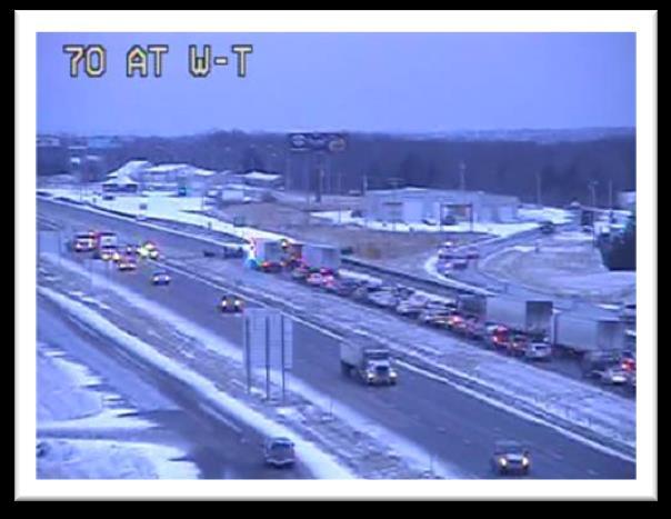
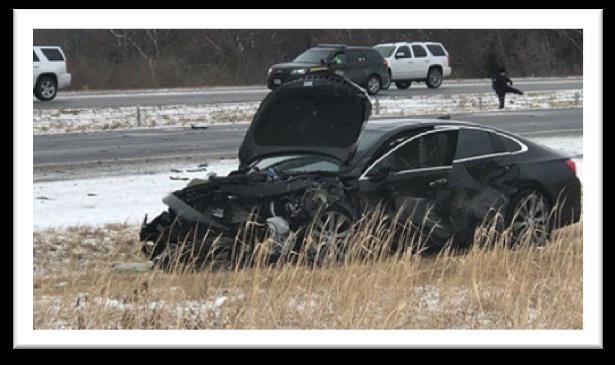
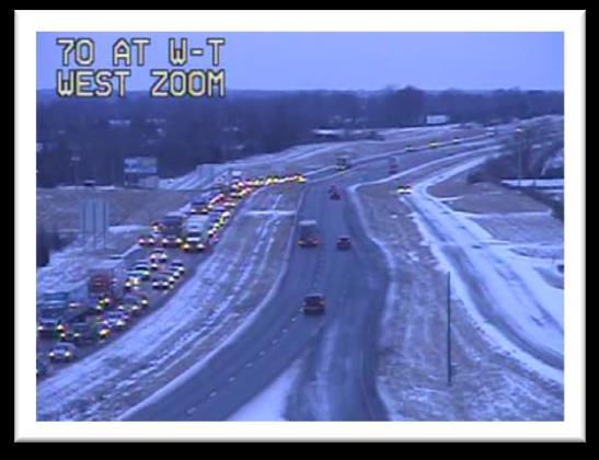
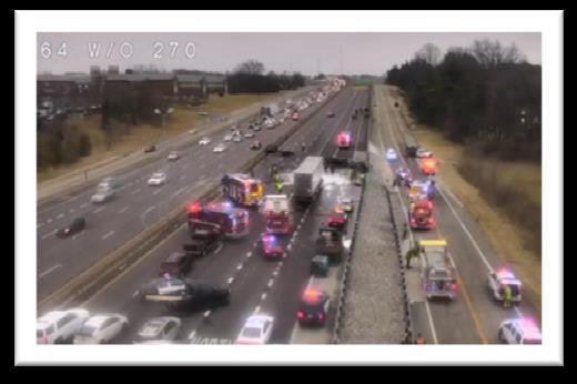
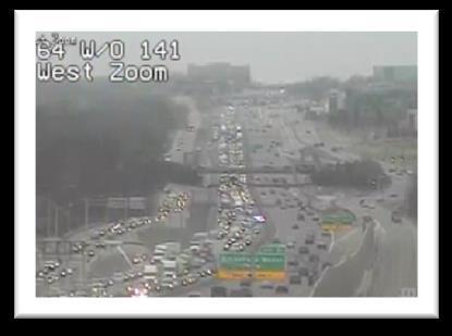
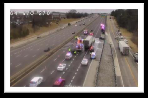
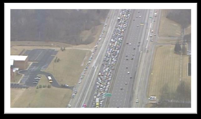
2 EXECUTIVE SUMMARY ZONING IN New Freeway Mobility Reporting Detailed For I-270 Corridor Average Time To Clear Lanes Increased From A Year Ago There Were 13 Fatal Crashes In January and 1 In February Work Zone Delays Confined To Poplar Street Bridge work EB I-70/I-55/US 40 Moved Up A Spot From # 2 in 2017 To # 1 On Top 5 Congestion Spots For January/February 2018 Most Significant Impact Events Planned Event TMS Work Zones: January 2018: 203 February 2018: 228 Work Zone Impact Breakdown: Major: 8 0.9% Moderate: % Minor: % WORK ZONE CRASHES: 5 Dates: Date:1-23 Location: Eastbound I-64 Poplar Street Bridge Event Detail: Bridge work 3 right lanes closed 25 minutes of additional travel time during non-peak period Unplanned Event Location: Eastbound I-64 before I- 270 Event Detail: Fatal Multi-vehicle crash involving a small car cutting in front of a tractor trailer causing a 6 car chain reaction crash 2
3 EXECUTIVE SUMMARY Top 5 Congestion Locations / January February 2017 vs Congestion Locations 2017 *Base Impact Average Queue Length Miles Average Daily Duration Total Duration 1 SB Galleria Parkway 11, h 04 m 5d 02h 29m 2 EB I-70/I-55/US40 11, h 36m 3d 22h 44m 3 SB MO100 Manchester Road 11, h 07m 5d 05h 36m 4 EB Big Bend Boulevard 10, h 55m 2d 06h 49m 5 WB Clayton Ave / Oakland Ave 10, h 17m 3d 04h 31m Locations ranked on *Base Impact (The aggregation of Queue Length over time for congestion originating at each location in mile minutes) Congestion Locations 2018 *Base Impact Average Queue Length Miles Average Daily Duration Total Duration 1 EB I-70/I-55/US40 21, h 29m 11d 00h 39m 2 WB Clayton Ave / Oakland Ave 9, h 23m 3d 09h 57m 3 EB Big Bend Boulevard 9, h 51m 2d 02h 33m 4 SB I-64/US 40/Eager Road 7, h 12m 5d 09h 58m 5 EB I-270@ US 67/Lindbergh Boulevard 7, h 53m 7d 02h 58m Locations ranked on *Base Impact (The aggregation of Queue Length over time for congestion originating at each location in mile minutes) Average Incident Duration Comparison / 2017 vs Month Average Incident Duration (Minutes : Seconds) January Lane Clearance 27:39 28:41 February Lane Clearance 25:52 26:17 January Incident Clearance 32:06 33:20 February Incident Clearance 29:06 31:35 3

4 FREEWAY MANAGEMENT Overall AM Regional Mobility DECREASED 6 am 7 am AM Peak Period Mobility January/February am 8 am 9 am 10 am 8 am 9 am AM Peak Period Mobility January/February am 7 am 7 am 8 am 8 am 9 am 9 am 10 am 4
5 FREEWAY MANAGEMENT Highlighted Corridor I-270 Comparing AM January/February 2017 to AM January/February 2018 AM Northbound I-270 Mobility DECREASED AM Southbound I-270 Mobility INCREASED
6 FREEWAY MANAGEMENT AM Northbound/Eastbound AM 7 AM 8 AM 9 AM 2 1 6
 during the 9am 10am hour.")
7 FREEWAY MANAGEMENT AM Northbound/Eastbound AM 7 AM 8 AM 9 AM 2 Mobility improvements between I-44 and Manchester Road (MO-100) during the 9am 10am hour. 1 Decreased mobility between Tesson Ferry and I-44 from 8:45am to 9:45am. 7

8 FREEWAY MANAGEMENT AM Westbound/Southbound AM 7 AM 8 AM 9 AM
 from 7:30am 8:30am. 5 2017 congestion between Olive Blvd. (MO 340) and Manchester (MO 100) not present in 2018.")
9 FREEWAY MANAGEMENT AM Westbound/Southbound AM 7 AM 8 AM 9 AM 3 Improved mobility between Washington/Elizabeth and McDonnell from 6:30am 8:30am. 4 Decreased mobility between Dorsett Road and Olive Blvd. (MO 340) from 7:30am 8:30am congestion between Olive Blvd. (MO 340) and Manchester (MO 100) not present in Congestion likely shifted upstream and accounted for between Dorsett and Olive. 9
10 FREEWAY MANAGEMENT Overall PM Regional Mobility DECREASED SLIGHTLY PM Peak Period Mobility January/February pm 4 pm 4 pm 5 pm 5 pm 6 pm 6 pm 7 pm A PM Peak Period Mobility January/February pm 4 pm 4 pm 5 pm 5 pm 6 pm 6 pm 7 pm 10
11 FREEWAY MANAGEMENT Highlighted Corridor I-270 Comparing PM January/February 2017 to PM January/February 2018 PM Northbound I-270 Mobility DECREASED PM Southbound I-270 Mobility INCREASED

12 FREEWAY MANAGEMENT PM Northbound/Eastbound PM 4 PM 5 PM 6 PM

13 FREEWAY MANAGEMENT PM Northbound/Eastbound PM 4 PM 5 PM 6 PM 1 Decreased mobility 4pm 5:15pm between Washington/Elizabeth and Route Decreased mobility between McDonnell and I-170 during the hour of 2:45pm 3:45pm. 13

14 FREEWAY MANAGEMENT PM Westbound/Southbound PM 4 PM 5 PM 6 PM
 and Dougherty Ferry from 6:15pm 7:00pm. 15")
15 FREEWAY MANAGEMENT PM Westbound/Southbound PM 4 PM 5 PM 6 PM 3 Improved mobility between I-64 and I-44 from 3:15pm 4:00pm. 4 Improved mobility in 2018 between Olive Blvd. (MO 340) and Dougherty Ferry from 6:15pm 7:00pm. 15
16 WORK ZONE MANAGEMENT TMC Observed Work Zones January 2018 February 2018 Level of Travel Time Impact Number of Work Zones Level of Travel Time Impact Number of Work Zones Major Impact 2 Major Impact 6 Moderate Impact 6 Moderate Impact 14 Minor Impact 162 Minor Impact 181 Total 170 Total 201 SL Mobility Rating: Jan 2018: 92% Feb 2018: 91% Goal: 91% *Impact Levels described in Data Key: SL Visibility levels: Jan 2018: 97% Feb 2018: 93% Goal: 91% 16
17 WORK ZONE MANAGEMENT Additional Travel Time Impacts through Work Zones Major Impact (15 Minutes or Above): # Moderate Impact (10-14 Minutes): # # # 1/1 2/28 (Daily) Eastbound I-64 Poplar Street Bridge 3 right lanes: Closed leaving one lane of traffic open eastbound before Poplar Street Bridge daily All mitigation efforts were in use RITIS data recorded additional travel times up to 25 minutes during non-peak hours

18 INCIDENT MANAGEMENT 18
19 INCIDENT MANAGEMENT 19
20 Incidents INCIDENT MANAGEMENT Total Number of Incidents: / December: 906 / January: 800 / February: Total Number of Lane Blocking Incidents Major Impact Incidents January 2018 vs. February 2018 (4) (3) Fatal Incidents January 2018 vs. February 2018 (13) (1) Tractor Trailer Incidents January 2018 vs. February 2018 (56) (43) I-270 I-70 I-64 I-44 I-55 I-170 Mo-364 Mo-370 All Others Dec Jan Feb
21 INCIDENT MANAGEMENT Lane Blocking Incidents by Freeway January and February 2018 Interstate Month Number of Incidents Average Time to Clear Incident from Lanes = T4 - T1 Average Time for Backup to Clear = T6 - T4 Freeway Miles Incidents per Mile I-44 Jan :37 00: I-44 Feb :53 00: I-55 Jan 68 19:16 00: I-55 Feb 76 24:07 00: I-64 Jan 96 25:42 01: I-64 Feb :02 01: I-70 Jan :51 02: I-70 Feb :55 01: I-170 Jan 60 25:40 00: I-170 Feb 32 21:54 01: I-270 Jan :11 02: I-270 Feb :25 01: MO-364 Jan 20 26:30 01: MO-364 Feb 20 14:36 00: MO-370 Jan 5 2:29:48 01: MO-370 Feb 8 18:37 00: Total Jan/Feb :00 01:

22 INCIDENT MANAGEMENT 22

23 INCIDENT MANAGEMENT 23
24 INCIDENT MANAGEMENT 2018 Tractor Trailer Incidents by Route 2018 I-44 I-55 I-64 I-70 I-170 I-255/I- Route Route Other Total Jan Feb Mar Apr May Jun Jul Aug Sep Oct Nov Dec Yearly Total
25 INCIDENT MANAGEMENT January 2018 February 2018 Tractor Trailer Incidents Map Number of Crashes: Incidents Crashes 25

26 INCIDENT MANAGEMENT January 2017 December 2017 Tractor Trailer Incidents Map Number of Crashes: Incidents Crashes 26
27 INCIDENT MANAGEMENT Incidents over Two Hours January / February 2018 Incidents in red denote high mobility impact Day of Duration # Date & Time Week Route Location Description HH/MM 1 1/5/ :08 Friday MO 370 EB TO MISSOURI BOTTOM RD Single Vehicle Overturned Tractor Trailer 11:03 2 1/8/ :24 Monday Route A TO MO 21 NB Ramp Fatal Crash 2:29 3 1/9/2018 6:45 Tuesday I-44 EB AT PARK AVE Pedestrian Struck By Hit And Run Driver 2:53 4 Multi-Vehicle Medical Emergency Fatal 1/9/ :27 Tuesday MO 94 WB BEFORE I-64 Crash 3:00 5 1/9/ :13 Tuesday 30 SP LOCAL HILLSBORO RD CRD Two-Vehicle Double Fatal Crash 3:35 6 1/13/2018 2:19 Saturday I-70 WB AT SALISBURY Fatal Crash With Ejection 2:55 7 1/14/ :34 Sunday US 67 SB PAST OLD LEMAY FERRY RD Fatal Crash 3:17 8 1/15/2018 7:39 Monday I-70 EB/WB PAST ROUTE T/W Fatal Crossover Crash 3:08 9 1/19/ :33 Friday MO 364 EB TO MO 94 WB Single-Vehicle Crash 2: /20/ :09 Saturday 61 US ROUTE W NB RT Two-Vehicle Fatal Crash 2: /21/2018 5:01 Sunday I-44 WB BEFORE I-64 Two-Vehicle Medical Emergency Crash 2: /22/2018 8:27 Monday I-70 EB AT I-270 Tractor Trailer Crash With State Damage 2: /23/2018 6:15 Tuesday I-170 NB BEFORE I-270 Rollover Crash With Serious Injuries 2: /23/2018 8:19 Tuesday I-64 EB/WB BEFORE I-270 Multi-Vehicle Fatal Crash TT Vs. Car 3: /23/ :13 Tuesday US 67 SB PAST MO 94 Stolen Vehicle Police Chase Crash 2: /24/ :42 Wednesday I-270 EB AT MO 367 Multi-Vehicle Chain Reaction Crash 2: /24/ :08 Wednesday 50 US DENMARK RD CRD Fatal Crash 4: /27/ :51 Saturday EB/WB 100 MO OO RT Motorcycle Vs Car Head-On Fatal Crash 2: /27/ :45 Saturday I-64 WB AT TIMBERLAKE MANOR PKWY High Speed Crash With Serious Injuries 4: /29/2018 5:34 Monday ST CHARLES ROCK RD PENNRIDGE DR CST Two-Vehicle Fatal Crash 3: /1/ :34 Thursday I-55 SB PAST POTOMAC ST Non-Hazmat Chemical Spill Cleanup 2: /4/2018 3:29 Sunday I-170 NB BEFORE AIRPORT RD Crash Involving A MSHP Vehicle Struck 2: /8/ :13 Thursday I-44 WB TO VANDEVENTER AVE Wrong-Way Driver Tractor Trailer Vs. Car 2: /10/ :32 Saturday I-44 WB PAST EXIT 225 MO 185/ROUTE D Tractor Trailer Crash Into Bridge Structure 4:54 27
28 INCIDENT MANAGEMENT # Date & Time Route Location Description Duration HH/MM 25 2/11/2018 3:57 Sunday I-70 EB BEFORE BRYAN RD Tractor Trailer Slid Off Roadway 6: /13/ :42 Tuesday E MANCHESTER RD S SAPPINGTON RD CST Sewer Grate Collapsed 2: /14/2018 4:57 Wednesday 340 MO EMERSON RD CST Power Lines Down Alongside Roadway 7: /14/2018 8:43 Wednesday AC RT PARKER SPUR CST School Bus Crash With Injuries 2: /17/2018 8:21 Saturday I-44 WB AT BOWLES AVE Tractor Trailer Crash 2: /19/ :57 Monday I-270 NB BEFORE DOUGHERTY FERRY RD Multi-Vehicle Crash 4: /19/ :48 Monday I-64 EB BEFORE GRAND BLVD Single-Vehicle Crash 3: /20/ :08 Tuesday I-44 WB AT I-64 Roadway Flooded Clogged MSD Drain 4: /23/2018 7:08 Friday I-70 WB PAST MO 370 A Tractor Trailer vs Car Crash TT Hit Barrier Wall Broke Both Axles 2:33 28

29 INCIDENT MANAGEMENT January / February 2018 Incidents with Mobility Impact Map Eastbound I-70 past Westbound I-70 past Route T Eastbound Route 370 MO 370 to MO Bottom Road Eastbound I-270 at Route 367 Eastbound I-44 at Park Avenue Westbound MO 94 before I-64 Eastbound I-64 before I-270 Northbound I-270 before Dougherty Ferry road Number of Crashes: Incidents Crashes Denotes Location of Major Impact Traffic Incidents 29
 100% Incident")


30 INCIDENT MANAGEMENT Major Impact Traffic Incidents and Mitigation 1/9/2018 (Tuesday) Time: 6:45 am 9:38 am *** Fatality *** Location: St. Louis City Eastbound I-44/Northbound I-55 at Park Avenue Event Type: Pedestrian Struck/Hit and Run Estimated Initial Impact: : Rush Hour: 3 of 3 travel lanes affected equals (=) 100% Incident Details: The TMC received a call from the St. Louis City Police Department advising them of an accident in which a pedestrian was struck. The vehicle involved had fled the scene without stopping. Action Taken: St. Louis City Police, Fire, and EMS responded, as did the MSHP who took command of the scene. The TMC immediately entered the incident into ATMS and activated all available DMS boards within one minute. This also created an event in TMS to notify the public of the closure. MoDOT Emergency Responders were dispatched and assisted with traffic control. All lanes of traffic were closed and drivers were diverted off onto Park Avenue as well as Truman Parkway with city streets used as a detour. A MoDOT Traffic Engineer was notified and began to adjust necessary signal timing for traffic. The ER Supervisor, Communication Staff, Maintenance Superintendent and the MoDOT Incident Management Coordinator were all notified. An incident alert was sent, updated and cleared to keep management informed of the closure. Reconstruction had a delayed response, which contributed to the extended duration of the incident. Emergency crews were able to get the right and exit lanes opened within 42 minutes to relieve some congestion. However, traffic queued approximately 5.2 miles on Northbound I-55 and approximately 1.1 miles on Eastbound I-44. It quickly returned to normal once all lanes were reopened. Event Duration: 2 hours 53 minutes Eastbound I-44/NB I-55 at Park Avenue Left Shoulder Lane 1 Lane 2 Lane 3 Exit Lane Right Shoulder Closed Hours/Minutes 2:53 2:53 2:53 0:42 0:42 0:42 30
31 INCIDENT MANAGEMENT Major Impact Traffic Incidents and Mitigation 1/15/2018 (Monday) Time: 7:39 am 10:48 am *** Fatality *** Location: St. Charles County Eastbound/Westbound I-70 past Route T Event: Two-Vehicle Crash Estimated Initial Impact: Rush Hour: 2 of 2 travel lanes affected equals (=) 100% Incident Details: The driver of a vehicle traveling westbound on I-70 fell asleep at the wheel causing the vehicle to travel off the left side of the roadway, over the cable barriers and onto Eastbound I-70. A second vehicle traveling eastbound struck the right side of the first vehicle. The front seat passenger of the first vehicle was pronounced on scene by Wentzville EMS. The driver and five additional passengers in the first vehicle were transported to a local hospital with injuries. This included 3 children ages 5 and under who were not in child safety seats. The driver of the second vehicle was transported with serious injuries. Action: Wentzville PD, Wright City PD, Fire, and St. Charles County and Warren County EMS responded, as did the MSHP who took command of the scene. Both lanes of Eastbound I-70 were closed and the #1 lane of Westbound I-70 was also closed for emergency vehicles. MoDOT Emergency Response assisted with traffic control, diverting drivers onto Veterans Memorial Parkway and the North Outer Road. The detour took drivers to Wentzville Parkway and back onto I-70. An Engineer was notified and began to adjust necessary signal timing for traffic. The ER Supervisor, Communication Staff, Maintenance Superintendent, EOC, Motor Carriers and the MoDOT Incident Management Coordinator were all notified. The TMC messaged for the event and entered it into TMS to notify the public of the closure. KC Scout was advised of the closure and helped message for eastbound traffic. An incident alert was sent to notify management of the closure. Reconstruction had a delayed response which contributed to the extended duration. Traffic queued approximately 4.8 miles on I-70 eastbound and approximately 2 miles on I-70 westbound. However, traffic returned to normal approximately 8 minutes after all lanes were opened. Event Duration: 3 hours 8 minutes Eastbound I-70 past Route T Left Shoulder Lane 1 Lane 2 Right Shoulder Closed Hours/Minutes 3:08 3:08 3:08 3:08 Westbound I-70 before Route T Left Shoulder Lane 1 Lane 2 Right Shoulder Closed Hours/Minutes 2:42 2:42 0:00 3:04 31

32 INCIDENT MANAGEMENT 32
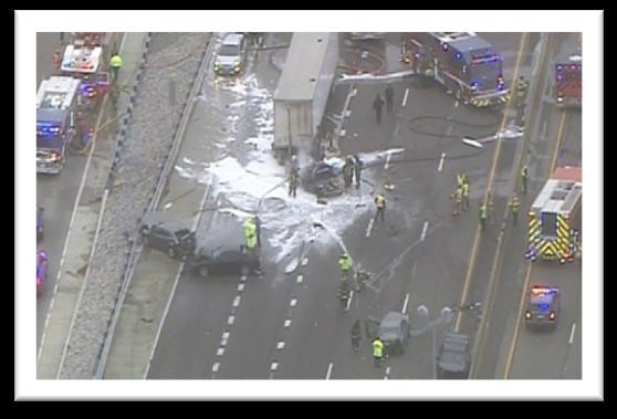
33 INCIDENT MANAGEMENT Major Impact Traffic Incidents and Mitigation 1/23/2018 (Tuesday) Time: 8:19 am 12:07 pm *** Fatality *** Location: St. Louis County Eastbound I-64 before I-270 Event: Multi-Vehicle Crash Estimated Initial Impact: Rush Hour: 5 of 5 travel lanes affected equals (=) 100% Incident Details: The TMC operators overheard units being dispatched to a multi-vehicle crash while monitoring police scanners. It was determined to be a chain reaction accident involving six vehicles including a tractor trailer. The driver of a small passenger vehicle cut in front of the tractor trailer who was unable to stop and rear ended the vehicle. The tractor trailer and passenger vehicle immediately burst into flames, fatally injuring the driver of the passenger vehicle. Three others were transported to a local hospital for treatment. Action: The MSHP, Town & Country Police, Des Peres Police, Creve Coeur Police, and West County Fire and EMS responded to work the scene. The TMC entered the incident into ATMS and activated available DMS boards within one minute. This also created an entry into TMS to notify the public. MoDOT Emergency Response Units were dispatched to assist with traffic control. All lanes of Eastbound I-64 were closed as were the two left lanes of Westbound I-64 to allow emergency responders additional room to work. Eastbound traffic was diverted onto MO 141 giving drivers several detour options. MoDOT Traffic Engineers were notified and began to adjust necessary signal timing to assist with the flow of the detoured traffic. The ER Supervisor, Communication Staff, Maintenance Superintendent, EOC, Motor Carriers and the MoDOT Incident Management Coordinator were all notified. Further, an incident alert and updates were sent to keep MoDOT management apprised as the incident progressed. Reconstruction had a delayed response and with maintenance sweeper down from Special Ops, SWAT was dispatched to manually sweep up the large amounts of debris. This contributed to the extended duration of the incident, as well as the number of vehicles involved and extent of damage. All vehicles had to be towed from the scene. Traffic queued approximately 5 miles on I-64 eastbound and approximately 1 mile on I-64 westbound, but returned to normal approximately 7 minutes after all lanes were opened Event Duration: 3 hours 48 minutes Eastbound I-64 before I-270 Left Shoulder Lane 1 Lane 2 Lane 3 Exit Lane 1 Exit Lane 2 Right Shoulder Closed Hours/Minutes 3:41 3:41 3:41 3:41 3:41 3:41 3:41 Westbound I-64 past I-270 Left Shoulder Lane 1 Lane 2 Lane 3 Lane 4 Exit Lane 1 Right Shoulder Closed Hours/Minutes 1:57 1:57 1:48 0:00 0:00 0:00 0:00 33


34 INCIDENT MANAGEMENT 34
ST. LOUIS DISTRICT MOBILITY
 ST. LOUIS DISTRICT MOBILITY QUARTERLY REGIONAL MOBILITY REPORT MARCH / APRIL / MAY 2018 EDITION NO. 03 Table of Contents EXECUTIVE SUMMARY Provide Outstanding Customer Service & Deliver Transportation
ST. LOUIS DISTRICT MOBILITY
 ST. LOUIS DISTRICT MOBILITY QUARTERLY REGIONAL MOBILITY REPORT SEPTEMBER / OCTOBER / NOVEMBER 2018 EDITION NO. 05 Table of Contents EXECUTIVE SUMMARY Provide Outstanding Customer Service & Deliver Transportation
St. Louis District Mobility
 St. Louis District Mobility November/December 2016 GuidePost Following historical trends, Freeway mobility improved from November to December in both peaks with seasonal changes impacting travel. Mobility
WIM #31 US 2, MP 8.0 EAST GRAND FORKS, MN JANUARY 2015 MONTHLY REPORT
 WIM #31 US 2, MP 8.0 EAST GRAND FORKS, MN JANUARY 2015 MONTHLY REPORT WIM #31 EAST GRAND FORKS MONTHLY REPORT - JANUARY 2015 WIM Site Location WIM #31 is located on US 2 at mile post 8.0, southeast of
St. Louis District Mobility
 St. Louis District Mobility November/December GuidePost 2015 Freeway Mobility remained consistent in Both November peaks with some improvements noted in the December AM Peak December PM Peak travel was
WIM #37 was operational for the entire month of September Volume was computed using all monthly data.
 SEPTEMBER 2016 WIM Site Location WIM #37 is located on I-94 near Otsego in Wright county. The WIM is located only on the westbound (WB) side of I-94, meaning that all data mentioned in this report pertains
WIM #29 was operational for the entire month of October Volume was computed using all monthly data.
 OCTOBER 2015 WIM Site Location WIM #29 is located on US 53 near Cotton in St Louis county. System Operation WIM #29 was operational for the entire month of October 2015. Volume was computed using all monthly
WIM #41 CSAH 14, MP 14.9 CROOKSTON, MINNESOTA MAY 2013 MONTHLY REPORT
 WIM #41 CSAH 14, MP 14.9 CROOKSTON, MINNESOTA MAY 2013 MONTHLY REPORT In order to understand the vehicle classes and groupings the Mn/DOT Vehicle Classification Scheme and the Vehicle Classification Groupings
WIM #41 CSAH 14, MP 14.9 CROOKSTON, MINNESOTA APRIL 2014 MONTHLY REPORT
 WIM #41 CSAH 14, MP 14.9 CROOKSTON, MINNESOTA APRIL 2014 MONTHLY REPORT In order to understand the vehicle classes and groupings, the MnDOT Vehicle Classification Scheme and the Vehicle Classification
NEWS RELEASE November 8, 2017
 NEWS RELEASE November 8, 2017 Contact: Marsha Roa Public Information Manager 909.839.7055 mroa@diamondbarca.gov GRAND AVENUE INTERCHANGE AT SR-57 (ORANGE) AND SR-60 (POMONA) MULTIPLE ROADWAY, RAMP AND
2017 Annual Report Kansas Department of Transportation
 2017 Annual Report Kansas Department of Transportation Wichita, Kansas ii ACKNOWLEDGEMENTS The 2017 Annual Report brought to you by the Kansas Department of Transportation (KDOT). iii INTRODUCTION The
Wichita TMC Support- Monthly Incident Report for December 2017
 Highway Wichita TMC Support- Monthly Incident Report for December 7 There were a total of 6 actively logged incidents during the month. The Traffic Management Center (TMC) is actively staffed 6am to 7pm,
Wichita TMC Support- Monthly Incident Report for July 2018
 Highway Wichita TMC Support- Monthly Incident Report for July 8 There were a total of actively logged incidents during the month. The Traffic Management Center (TMC) is actively staffed 6am to pm, Monday-Friday,
Appendix SAN San Diego, California 2003 Annual Report on Freeway Mobility and Reliability
 (http://mobility.tamu.edu/mmp) Office of Operations, Federal Highway Administration Appendix SAN San Diego, California 2003 Annual Report on Freeway Mobility and Reliability This report is a supplement
Wichita TMC Support- Monthly Incident Report for June 2018
 Highway Wichita TMC Support- Monthly Incident Report for June 208 There were a total of 256 actively logged incidents during the month. The Traffic Management Center (TMC) is actively staffed 6am to 7pm,
I-405 Sepulveda Pass Improvements Project
 I-405 Sepulveda Pass Improvements Project 26, 2012 Click to edit Master title January style Community Advisory Committee 1 Community Meeting Schedule for 2012 26-Jan CAC, Final Meeting Feb 22-Mar Community
Operate a Reliable and Convenient. Becky Allmeroth, State Maintenance Engineer. Tracker. Measures of Departmental Performance
 Operate a Reliable and Convenient Transportation System Becky Allmeroth, State Maintenance Engineer Tracker Measures of Departmental Performance Missourians expect to get to their destinations on time,
WIM #48 is located on CSAH 5 near Storden in Cottonwood county.
 WIM Site Location WIM #48 is located on CSAH 5 near Storden in Cottonwood county. System Operation WIM #48 was operational for the entire month of August 2017. Volume was computed using all monthly data.
2016 Congestion Report
 2016 Congestion Report Metropolitan Freeway System May 2017 2016 Congestion Report 1 Table of Contents Purpose and Need...3 Introduction...3 Methodology...4 2016 Results...5 Explanation of Percentage Miles
2013 Operations Statistics Report Triangle Expressway Fourth Quarter
 2013 Operations Statistics Report Fourth Quarter 1 S. Wilmington Street Raleigh, C 27601 2012 Annual Operations Last Updated: Report 1 11, 2014 Table of Contents 2013 Fourth Quarter Operations Statistics
COMPARISON OF FIXED & VARIABLE RATES (25 YEARS) CHARTERED BANK ADMINISTERED INTEREST RATES - PRIME BUSINESS*
 CHARTERED BANK ADMINISTERED INTEREST RATES - PRIME BUSINESS*") COMPARISON OF FIXED & VARIABLE RATES (25 YEARS) 2 Fixed Rates Variable Rates For Internal Use Only. FIXED RATES OF THE PAST 25 YEARS AVERAGE RESIDENTIAL MORTGAGE LENDING RATE - 5 YEAR* (Per cent) Year
COMPARISON OF FIXED & VARIABLE RATES (25 YEARS) 2 Fixed Rates Variable Rates For Internal Use Only. FIXED RATES OF THE PAST 25 YEARS AVERAGE RESIDENTIAL MORTGAGE LENDING RATE - 5 YEAR* (Per cent) Year
COMPARISON OF FIXED & VARIABLE RATES (25 YEARS) CHARTERED BANK ADMINISTERED INTEREST RATES - PRIME BUSINESS*
 CHARTERED BANK ADMINISTERED INTEREST RATES - PRIME BUSINESS*") COMPARISON OF FIXED & VARIABLE RATES (25 YEARS) 2 Fixed Rates Variable Rates FIXED RATES OF THE PAST 25 YEARS AVERAGE RESIDENTIAL MORTGAGE LENDING RATE - 5 YEAR* (Per cent) Year Jan Feb Mar Apr May Jun
COMPARISON OF FIXED & VARIABLE RATES (25 YEARS) 2 Fixed Rates Variable Rates FIXED RATES OF THE PAST 25 YEARS AVERAGE RESIDENTIAL MORTGAGE LENDING RATE - 5 YEAR* (Per cent) Year Jan Feb Mar Apr May Jun
CLEARWATER POLICE DEPARTMENT. Traffic Safety Improvement Program July 1, 2012 to June 30, 2014
 CLEARWATER POLICE DEPARTMENT Traffic Safety Improvement Program July 1, 2012 to June 30, 2014 Red Light Cameras were installed at two intersections to help reduce the number of red light running crashes
Speed Limit and Safety Nexus Studies for Automated Enforcement Locations in the District of Columbia 3rd Street Tunnel at Massachusetts Avenue Exit
 Speed Limit and Safety Nexus Studies for Automated Enforcement Locations in the District of Columbia 3rd Street Tunnel at Massachusetts Avenue Exit Study Area and Location District PSA Ward ANC Phase Description
TxDOT TRAFFIC INCIDENT MANAGEMENT UPDATE. ITS Texas 2016
 TxDOT TRAFFIC INCIDENT MANAGEMENT UPDATE ITS Texas 2016 November 10, 2016 TxDOT- Traffic Operations Division November 10, 2016 Performance Measures (Lonestar ATMS) Lonestar ATMS Upgraded to Support Incident
Figure 1 Map of intersection of SR 44 (Ravenna Rd) and Butternut Rd
 and Butternut Rd") Abbreviated Study District: 12 County: Geauga Route: SR 44 Section: 1.58 GEA 44 1.58 213 HSP # 47 (Rural Intersection) Prepared April 23, 215 By Bryan Emery Existing Conditions This study contains the
Abbreviated Study District: 12 County: Geauga Route: SR 44 Section: 1.58 GEA 44 1.58 213 HSP # 47 (Rural Intersection) Prepared April 23, 215 By Bryan Emery Existing Conditions This study contains the
Metropolitan Freeway System 2013 Congestion Report
 Metropolitan Freeway System 2013 Congestion Report Metro District Office of Operations and Maintenance Regional Transportation Management Center May 2014 Table of Contents PURPOSE AND NEED... 1 INTRODUCTION...
Traffic Accident Statistics
 2000 Missouri State Highway System Traffic Accident Statistics Missouri State Highway System Traffic Accident Statistics Table of Contents Subject Chapter 1: Statewide Traffic Accident Statistics, Introduction
Collision Analysis Safety Tables
 Crash Severity Geography of Geography of Time and Date of Crash Conditions Features Features.. Queries Selected: Town(Hartford), Date(Year:All or //05 to 9/7/06), Severity(All), Route Class(Interstate),
Study Area and Location District PSA Ward ANC Phase Description C Planned Suitland Parkway Westbound at Stanton Road Southeast
 Speed Limit and Safety Nexus Studies for Automated Enforcement Locations in the District of Columbia Suitland Parkway at Stanton Road SE Study Area and Location District PSA Ward ANC Phase Description
Project Advisory Committee
 Meredith US 3/NH 25 Improvements Transportation Planning Study Project Advisory Committee March 18, 2008 Meredith US 3/NH 25 Improvements Transportation Planning Study Meeting Agenda Welcome Traffic Model
1999 Missouri State Highway System. Missouri Department of Transportation - Transportation Management Systems
 1999 Missouri State Highway System Traffic Accident Statistics - Transportation Management Systems Missouri State Highway System Traffic Accident Statistics Table of Contents Subject Chapter 1: Statewide
I-405 Sepulveda Pass Improvements Project
 I-405 Sepulveda Pass Improvements Project Community Meeting November 15, 2012 1 Wilshire Segment Overview of Wilshire Segment There are a total of 23 bridges being constructed on this project; almost half
WIM #40 is located on US 52 near South St. Paul in Dakota county.
 WIM Site Location WIM #40 is located on US 52 near South St. Paul in Dakota county. System Operation WIM #40 was operational for the entire month of November 2017. Volume was computed using all monthly
Operate a Reliable and Convenient. Becky Allmeroth, State Maintenance Engineer. Tracker. Measures of Departmental Performance
 Operate a Reliable and Convenient Transportation System Becky Allmeroth, State Maintenance Engineer Tracker Measures of Departmental Performance Missourians expect to get to their destinations on time,
RTCSNV CRASH ANALYSIS REPORT
 2011-2015 RTCSNV CRASH ANALYSIS REPORT TABLE OF CONTENTS Summary... 3 Crash Types... 4 Time and Day of Crashes... 7 Crash Factors... 9 Fatalities... 10 Driver s Behavior... 11 Crash Locations... 15 Non-Motorized
Algo Traffic and the Tuscaloosa RTMC. Chris Sewell, P.E. ITS Operations Manager ALDOT West Central Region
 Algo Traffic and the Tuscaloosa RTMC Chris Sewell, P.E. ITS Operations Manager ALDOT West Central Region Outline Partnerships with the University of Alabama Tuscaloosa Traffic Management Center Algo Traffic
WIM #39 MN 43, MP 45.2 WINONA, MN APRIL 2010 MONTHLY REPORT
 WIM #39 MN 43, MP 45.2 WINONA, MN APRIL 2010 MONTHLY REPORT In order to understand the vehicle classes and groupings the Mn/DOT Vehicle Classification Scheme and the Vehicle Class Groupings for Forecasting
Alberta. Collision Facts. 330 people killed. 17,907 people injured. 140,705 collisions.
 Collision Facts 330 people killed 17,907 people injured 140,705 collisions May 2017 www.transportation.alberta.ca/statistics Collision Facts 330 people killed 17,907 people injured 140,705 collisions Monday
Tracker. Operate a reliable and COnvenient transportation system. Becky Allmeroth, Chief Safety and Operations Officer
 Operate a reliable and COnvenient transportation system Becky Allmeroth, Chief Safety and Operations Officer Tracker Measures of Departmental Performance Missourians expect to get to their destinations
Request for Design Exception (#1) S.M. Wright Phase IIB
 S.M. Wright Phase IIB") Request for Design Exception (#1) S.M. Wright Phase IIB County: Dallas CSJ s: 0092-01-059, 0092-14-088 Project Limits: From Pennsylvania Avenue to North of Al Lipscomb Way Date: June 28, 2016 Proposed
Request for Design Exception (#1) S.M. Wright Phase IIB County: Dallas CSJ s: 0092-01-059, 0092-14-088 Project Limits: From Pennsylvania Avenue to North of Al Lipscomb Way Date: June 28, 2016 Proposed
Study Area and Location District PSA Ward ANC Phase Description C Existing 100 Block Michigan Avenue Northeast Westbound
 Speed Limit and Safety Nexus Studies for Automated Enforcement Locations in the District of Columbia 1 Block Michigan Avenue NE W/B Study Area and Location District PSA Ward ANC Phase Description 5 45
Florida s Turnpike Enterprise. Incident Management Program for All Levels & Specialty Towing & Roadside Repair (STARR)
") Florida s Turnpike Enterprise Incident Management Program for All Levels & Specialty Towing & Roadside Repair (STARR) Florida s Turnpike System Largest Toll System in Florida 460 Centerline Miles 2 Million
Florida s Turnpike Enterprise Incident Management Program for All Levels & Specialty Towing & Roadside Repair (STARR) Florida s Turnpike System Largest Toll System in Florida 460 Centerline Miles 2 Million
Transit City Etobicoke - Finch West LRT
 Delcan Corporation Transit City Etobicoke - Finch West LRT APPENDIX D Microsimulation Traffic Modeling Report March 2010 March 2010 Appendix D CONTENTS 1.0 STUDY CONTEXT... 2 Figure 1 Study Limits... 2
Expo Light Rail Line Project Status Update Meeting Holman United Methodist Church January 27, 2011
 Project Status Update Meeting Project Status Update Meeting Holman United Methodist Church January 27, 2011 Phase 1 Project Description Phase 1 from Downtown Los Angeles to Culver City: 8.6 mile corridor
Traffic Engineering Study
 Traffic Engineering Study Bellaire Boulevard Prepared For: International Management District Technical Services, Inc. Texas Registered Engineering Firm F-3580 November 2009 Executive Summary has been requested
Red Light Cameras in Austin. Austin Police Department Highway Enforcement Command
 Red Light Cameras in Austin Austin Police Department Highway Enforcement Command video MLK WB/I35 EF SB Video 2014 Red Light Violations Ø 10 camera approaches (direction of cameras) in Austin throughout
WIM #40 US 52, MP S. ST. PAUL, MN APRIL 2010 MONTHLY REPORT
 WIM #40 US 52, MP 126.8 S. ST. PAUL, MN APRIL 2010 MONTHLY REPORT In order to understand the vehicle classes and groupings the Mn/DOT Vehicle Classification Scheme and the Vehicle Class Groupings for Forecasting
TABLE OF CONTENTS CRASHES.. VI TRENDS. VII
 TABLE OF CONTENTS Introduction. I Letter from the Governor II Executive Summary of this Report. III-IV 1998 Nevada Quick Collision Facts V CRASHES.. VI a. Statewide Total Crashes by Severity... 1 b. Statewide
RIDERSHIP TRENDS. March 2017
 RIDERSHIP TRENDS March 2017 Prepared by the Division of Strategic Capital Planning May 2017 Table of Contents Executive Summary...1 Ridership...3 Estimated Passenger Trips by Line...3 Estimated Passenger
ALCOHOL AND WYOMING TRAFFIC CRASHES
 AND WYOMING TRAFFIC -2007- 2002-2007 SUMMARY COMPARISON FOR WYOMING TRAFFIC YEAR OF 2002 2003 2004 2005 2006 2007 ALL FATAL 151 141 142 147 169 136 FATAL 53 43 50 51 58* 46* PERCENT [%] 35.0% 30.5% 35.2%
Speed Limit and Safety Nexus Studies for Automated Enforcement Locations in the District of Columbia 400 Block 14th Street SW
 Speed Limit and Safety Nexus Studies for Automated Enforcement Locations in the District of Columbia 4 Block 4th Street SW Study Area and Location District PSA Ward ANC Phase Description 27 6 6D Existing
Monterey County Freeway Service Patrol Annual Report
 Monterey County Freeway Service Patrol Annual Report Fiscal Year 2012 2013 Tow Trucks to the Rescue What is the Freeway Service Patrol Program? The purpose of the Freeway Service Patrol is to provide for
Commercial-in-Confidence Ashton Old Baths Financial Model - Detailed Cashflow
 Year 0 1 2 3 4 5 6 7 8 9 10 11 12 13 Oct-16 Nov-16 Dec-16 Jan-17 Feb-17 Mar-17 Apr-17 May-17 Jun-17 Jul-17 Aug-17 Sep-17 Oct-17 2,038 2,922 4,089 4,349 6,256 7,124 8,885 8,885 8,885 8,885 8,885 8,885 9,107
1. Incident I-10 West Bound, MM 17.9, Overturned Gas Tanker, on Fire and Leaking Fuel
 1. Incident I-10 West Bound, MM 17.9, Overturned Gas Tanker, on Fire and Leaking Fuel 2. Incident I-110 South Bound, MM 4.1, overturned Greyhound Bus (full of passengers) multiple injuries, some critical
CITY OF BEVERLY HILLS STAFF REPORT
 Meeting Date: July 7, 2011 To: From: Subject: CITY OF BEVERLY HILLS STAFF REPORT Honorable Mayor & City Council Pamela Mottice Muller, Director of Emergency Management 405 Closure Attachments: 1. 1-405
Annual Statistical Report
 Metro Area Motorist Assist Program Annual Statistical Report January - December Metro Area Motorist Assist Program Annual Statistical Report Table of Contents i. Introduction... i-iii ii. Report Maps...
FREQUENTLY ASKED QUESTIONS
 THE PROJECT Last updated on 9/8/16 FREQUENTLY ASKED QUESTIONS What s happening on Highway 169? The Minnesota Department of Transportation (MnDOT) is planning to rebuild and repair the infrastructure on
LAWRENCE TRANSIT CENTER LOCATION ANALYSIS 9 TH STREET & ROCKLEDGE ROAD / 21 ST STREET & IOWA STREET LAWRENCE, KANSAS
 LAWRENCE TRANSIT CENTER LOCATION ANALYSIS 9 TH STREET & ROCKLEDGE ROAD / 21 ST STREET & IOWA STREET LAWRENCE, KANSAS TRAFFIC IMPACT STUDY FEBRUARY 214 OA Project No. 213-542 TABLE OF CONTENTS 1. INTRODUCTION...
Interstate Operations Study: Fargo-Moorhead Metropolitan Area Simulation Output
 NDSU Dept #2880 PO Box 6050 Fargo, ND 58108-6050 Tel 701-231-8058 Fax 701-231-6265 www.ugpti.org www.atacenter.org Interstate Operations Study: Fargo-Moorhead Metropolitan Area 2015 Simulation Output Technical
Metropolitan Freeway System 2007 Congestion Report
 Metropolitan Freeway System 2007 Congestion Report Minnesota Department of Transportation Office of Traffic, Safety and Operations Freeway Operations Section Regional Transportation Management Center March
Event Chronology. Sarasota I-75 NB Exit SUMTER BLVD. County: Road: Location: Rollover:
 Created On: Center: Filter Parameters Selected: Period: Event(s) Found: Event ID Range: 06/23/2016 12:25:54 06/23/2016 1 317,087 Event #: 317087 Event Type: Crash Report Date: 06/23/2016 08:37:22 Status:
ODOT District Two Monthly Construction Update
 Ohio Department of Transportation Construction Update DISTRICT 2 KIRK SLUSHER, P.E., ACTING DEPUTY DIRECTOR 317 East Poe Rd. Bowling Green, Ohio 43402-1330 www.transportation.ohio.gov/dist2 ODOT District
TRAFFIC IMPACT STUDY DERRY GREEN CORPORATE BUSINESS PARK MILTON SECONDARY PLAN MODIFICATION
 TRAFFIC IMPACT STUDY DERRY GREEN CORPORATE BUSINESS PARK MILTON SECONDARY PLAN MODIFICATION TRAFFIC IMPACT STUDY DERRY GREEN CORPORATE BUSINESS PARK MILTON SECONDARY PLAN MODIFICATION DECEMBER 24 UPDATED
IH 45 (GULF FWY) IH 10 (Katy Fwy) to IH 610 S (South Loop) 2010 Rank: Rank: 12
 IH 10 (Katy Fwy) to IH 610 S (South Loop) 2010 Rank: Rank: 12") Mobility Investment Priorities Project Houston IH 45 IH 45 (GULF FWY) IH 10 (Katy Fwy) to IH 610 S (South Loop) Current Conditions From IH 10 to IH 610 south, IH 45 is a 6- to 9-lane facility with three
Mobility Investment Priorities Project Houston IH 45 IH 45 (GULF FWY) IH 10 (Katy Fwy) to IH 610 S (South Loop) Current Conditions From IH 10 to IH 610 south, IH 45 is a 6- to 9-lane facility with three
USE RESTRICTED 23 USC 409
 Study Map & Totals Legend Fatality Injury Property Damage Remarks: NONE Date Range: 01-01-2010 thru 12-31-2014 2010 2011 2012 Fat Incap Inj Non-Incap Inj Poss Inj PD Tot Fat Incap Inj Non-Incap Inj Poss
EXECUTIVE SUMMARY. The following is an outline of the traffic analysis performed by Hales Engineering for the traffic conditions of this project.
 EXECUTIVE SUMMARY This study addresses the traffic impacts associated with the proposed Shopko redevelopment located in Sugarhouse, Utah. The Shopko redevelopment project is located between 1300 East and
Sound Transit Operations July 2016 Service Performance Report. Ridership
 Ridership Total Boardings by Mode Mode Jul-15 Jul-16 % YTD-15 YTD-16 % ST Express 1,618,779 1,545,852-4.5% 10,803,486 10,774,063-0.3% Sounder 333,000 323,233-2.9% 2,176,914 2,423,058 11.3% Tacoma Link
ODOT District Two Monthly Construction Update
 Ohio Department of Transportation Construction Update DISTRICT 2 KIRK SLUSHER, P.E., ACTING DEPUTY DIRECTOR 317 East Poe Rd. Bowling Green, Ohio 43402-1330 www.transportation.ohio.gov/dist2 ODOT District
Countdown to the Closure Extended 53-Hour Closure of I-405 Freeway Between U.S. 101 and I-10 Planned in Mid-July for Mulholland Bridge Demolition
 Countdown to the Closure Extended 3-Hour Closure of I-40 Freeway Between U.S. 0 and I-0 Planned in Mid-July for Mulholland Bridge Demolition Work Los Angeles, Calif. Plan Ahead, Avoid The Area, Or Stay
Study Area and Location District PSA Ward ANC Phase Description B Existing 600 Block New York Avenue Northeast Westbound
 Speed Limit and Safety Nexus Studies for Automated Enforcement Locations in the District of Columbia 6 Block New York Avenue NE Study Area and Location District PSA Ward ANC Phase Description 5 55 5 5B
Presentation to the Customer Service, Operations and Safety Committee OPERATIONS PERFORMANCE INDICATORS
 Presentation to the Customer Service, Operations and Safety Committee OPERATIONS PERFORMANCE INDICATORS May 19, 2005 Department of Operations 100 95 90 85 80 75 70 65 A B C D RAIL PERFORMANCE INDEX FY
Over-Dimensional Vehicle Restriction Study for US 129 in TN
 Over-Dimensional Vehicle Restriction Study for US 129 in TN July 30,2015 TDOT Region 1 US 129 Location Map US 129 Topography and Scenery Operational and Safety Study August 2014, US129 Operational and
Wisconsin Motor Vehicle Crash Report. Agency Crash Number Date Arrived 11/17/2017. Total Units 02. School Bus Related No
 Document Number Override Crash Date 11/17/27 Date tified 11/17/27 On Emergency Government Property Reportable Description Diagram Primary Crash Document # Crash Time 4:35 PM Time tified 4:35 PM Hit and
MEMO VIA . Ms. Amy Roth DPS Director, City of Three Rivers. To:
 MEMO To: Ms. Amy Roth DPS Director, City of Three Rivers VIA EMAIL From: Michael J. Labadie, PE Julie M. Kroll, PE, PTOE Brandon Hayes, PE, P.Eng. Fleis & VandenBrink Date: January 5, 2017 Re: Proposed
County State Aid Highway 30 (Diffley Road) and Dodd Road Intersection Study
 and Dodd Road Intersection Study") County State Aid Highway 30 (Diffley Road) and Dodd Road Intersection Study City of Eagan, Dakota County, Minnesota Date: March 2012 Project No. 14957.000 444 Cedar Street, Suite 1500 Saint Paul, MN 55101
County State Aid Highway 30 (Diffley Road) and Dodd Road Intersection Study City of Eagan, Dakota County, Minnesota Date: March 2012 Project No. 14957.000 444 Cedar Street, Suite 1500 Saint Paul, MN 55101
US 59 (SOUTHWEST FWY) IH 610 (West Loop) to SH 288 (South Fwy)
 IH 610 (West Loop) to SH 288 (South Fwy)") Mobility Investment Priorities Project Houston US 59 US 59 (SOUTHWEST FWY) IH 610 (West Loop) to SH 288 (South Fwy) Current Conditions From IH 610 West to SH 288, US 59 operates with four or five lanes
Mobility Investment Priorities Project Houston US 59 US 59 (SOUTHWEST FWY) IH 610 (West Loop) to SH 288 (South Fwy) Current Conditions From IH 610 West to SH 288, US 59 operates with four or five lanes
New Buck O Neil (U. S. 169) Crossing Benefit-Cost Analysis. Kansas City, Missouri
 Crossing Benefit-Cost Analysis. Kansas City, Missouri") New Buck O Neil (U. S. 169) Crossing Benefit-Cost Analysis Kansas City, Missouri New Buck O Neil (U. S. 169) Crossing Benefit-Cost Analysis prepared for Kansas City, Missouri prepared by Burns & McDonnell
New Buck O Neil (U. S. 169) Crossing Benefit-Cost Analysis Kansas City, Missouri New Buck O Neil (U. S. 169) Crossing Benefit-Cost Analysis prepared for Kansas City, Missouri prepared by Burns & McDonnell
Strategies to keep people and goods moving in and through Seattle
 Strategies to keep people and goods moving in and through Seattle SR 99 Closure and the Seattle Squeeze 2018-2024 DON Information Session Department of Transportation Delridge Community Center November
PROJECT: Wilkinson Road Corridor Improvement Traffic Management Planning Project SUBJECT: Traffic Analysis
 TECHNICAL MEMORANDUM DATE: September 10, 2014 PROJECT 5861.03 NO: PROJECT: Wilkinson Road Corridor Improvement Traffic Management Planning Project SUBJECT: Traffic Analysis TO: Steve Holroyd - District
MILLERSVILLE PARK TRAFFIC IMPACT ANALYSIS ANNE ARUNDEL COUNTY, MARYLAND
 MILLERSVILLE PARK TRAFFIC IMPACT ANALYSIS ANNE ARUNDEL COUNTY, MARYLAND Prepared for: Department of Public Works Anne Arundel County Prepared by: URS Corporation 4 North Park Drive, Suite 3 Hunt Valley,
MO 370 Interchange Ramp at Salt River Road - Phase 1
 MO 3 Interchange Ramp at Salt River Road - Phase 1 Sponsor St Peters Project No. RB19-000023 Project Type New Road TOTAL FUNDING Total County Sponsor Federal $3,304,748.00 $1,652,298.00 $7,450.00 $945,000.00
Regional Safety Study
 BOONSLICK REGIONAL PLANNING COMMISSION Regional Safety Study PART I: General Crash Data and Trends SPRING 2012 BRPC REGIONAL SAFETY STUDY: PART 1 ~ GENERAL CRASH DATA & TRENDS 1 TABLE OF CONTENTS REPORT
VEHICLE / PEDESTRIAN COLLISIONS
 Info item No. 1 Crosswalk Safety Advisory Committee March 31, 2016 VEHICLE / PEDESTRIAN COLLISIONS HRM: January December 20 DISCLAIMER: All figures presented in this report reflect the information held
Safety Assessment. Intersection of Route 29 (Seminole Trail) and Ashwood Blvd (Route 1670). Albemarle County
 and Ashwood Blvd (Route 1670). Albemarle County") Safety Assessment for Intersection of Route 29 (Seminole Trail) and Ashwood Blvd (Route 1670). Albemarle County Prepared by: VIRGINIA DEPARTMENT OF TRANSPORTATION Northwestern Regional Operations - Traffic
Safety Assessment for Intersection of Route 29 (Seminole Trail) and Ashwood Blvd (Route 1670). Albemarle County Prepared by: VIRGINIA DEPARTMENT OF TRANSPORTATION Northwestern Regional Operations - Traffic
Study Area and Location District PSA Ward ANC Phase Description A Proposed Monroe Street Northeast Eastbound at Rhode Island Avenue
 Speed Limit and Safety Nexus Studies for Automated Enforcement Locations in the District of Columbia Monroe Street NE and Rhode Island Avenue NE Study Area and Location District PSA Ward ANC Phase Description
IMPROVEMENT CONCEPTS
 IMPROVEMENT CONCEPTS for the South Novato Transit Hub Study Prepared by: January 11, 2010 DKS Associates With Wilbur Smith Associates IMPROVEMENT CONCEPTS Chapter 1: Introduction 1. INTRODUCTION The strategic
FREQUENTLY ASKED QUESTIONS
 THE PROJECT Last updated on 2/19/16 FREQUENTLY ASKED QUESTIONS What s happening on Highway 169? The Minnesota Department of Transportation (MnDOT) is planning to rebuild and repair the infrastructure on
Memorandum. To: Sue Polka, City Engineer, City of Arden Hills. From: Sean Delmore, PE, PTOE. Date: June 21, 2017
 Memorandum engineering planning environmental construction 701 Xenia Avenue South Suite 300 Minneapolis, MN 55416 Tel: 763-541-4800 Fax: 763-541-1700 To: Sue Polka, City Engineer, City of Arden Hills From:
Florida Department of Transportation. Road Ranger Performance Measures 2nd Quarter Report. October 1 to December 31, 2014 Fiscal Year (FY) 2014/2015
 2014/2015") Florida Department of Transportation Road Ranger Performance Measures 2nd Quarter Report October 1 to December 31, 2014 Fiscal Year (FY) 2014/2015 Prepared by: Florida Department of Transportation Commercial
Florida Department of Transportation Road Ranger Performance Measures 2nd Quarter Report October 1 to December 31, 2014 Fiscal Year (FY) 2014/2015 Prepared by: Florida Department of Transportation Commercial
Bennett Pit. Traffic Impact Study. J&T Consulting, Inc. Weld County, Colorado. March 3, 2017
 Bennett Pit Traffic Impact Study J&T Consulting, Inc. Weld County, Colorado March 3, 217 Prepared By: Sustainable Traffic Solutions, Inc. http://www.sustainabletrafficsolutions.com/ Joseph L. Henderson,
TRAFFIC SIGNAL DESIGN REPORT KING OF PRUSSIA ROAD & RAIDER ROAD RADNOR TOWNSHIP PENNSYLVANIA
 TRAFFIC SIGNAL DESIGN REPORT KING OF PRUSSIA ROAD & RAIDER ROAD RADNOR TOWNSHIP PENNSYLVANIA PREPARED FOR: UNIVERSITY OF PENNSYLVANIA HEALTH SYSTEM 34 CIVIC CENTER BOULEVARD PHILADELPHIA, PA 1987 (61)
Department of Highway Safety and Motor Vehicles
 Department of Highway Safety and Motor Vehicles Traffic Report 2005 A Compilation of Motor Vehicle Crash Data from the Florida Crash Records Database Fred O. Dickinson Executive Director Our Mission: Making
Traffic Analysis for Bon Air Bridge Mitigation Magnolia Storm Water Quality Project
 Memo To: Paul DiDonato, ATI Architects and Engineers From: David Parisi, PE and Ashley Tam, EIT Date: February 23, 216 Subject: Traffic Analysis for Bon Air Bridge Mitigation Magnolia Storm Water Quality
USE RESTRICTED 23 USC 409
 Created: 04/29/2016 by Randy Woods Study Map & Totals Legend Fatality Injury Property Damage Remarks: NONE Date Range: 01-01-2006 thru 12-31-2015 2006 2007 2008 Fat Incap Inj Non-Incap Inj Poss Inj PD
Proposed location of Camp Parkway Commerce Center. Vicinity map of Camp Parkway Commerce Center Southampton County, VA
 Proposed location of Camp Parkway Commerce Center Vicinity map of Camp Parkway Commerce Center Southampton County, VA Camp Parkway Commerce Center is a proposed distribution and industrial center to be
STATE OF NEW YORK DEPARTMENT OF TRANSPORTATION OFFICE OF ENGINEERING AMENDMENT NO. 4 TO: IN THE LETTING OF FEBRUARY 21, 2013
 STATE OF NEW YORK DEPARTMENT OF TRANSPORTATION OFFICE OF ENGINEERING AMENDMENT NO. 4 TO: ALBANY, NEW YORK FEBRUARY 5, 2013 D262162 F. A. PROJECT BRONX COUNTY CPIN X806.63 STATE OF GOOD REPAIR III IN THE
Study Area and Location District PSA Ward ANC Phase Description C Proposed 2600 Block Lincoln Road Northeast Northbound
 Speed Limit and Safety Nexus Studies for Automated Enforcement Locations in the District of Columbia 2600 Block Lincoln Road NE Study Area and Location District PSA Ward ANC Phase Description 5 502 5 5C
Existing Conditions Belmont Circle Bourne, MA. Belmont Circle Improvements
 Existing Conditions Belmont Circle Bourne, MA Speakers Pam Haznar, MassDOT Ed Hollingshead, Fay Spofford & Thorndike Heather Ostertog, Fay, Spofford & Thorndike Goals for Group Local Knowledge Work through
Brookline Police Department
 Brookline Police Department Week to Date Chart of Part A Crimes Reporting Period 1/01/2018-10/14/2018 YTD Year to Date Year 2017 2018 % Murder 0 0 0% 0 Rape 5 1-80% 0 Robbery 5 7 40% 0 Assault 103 100-3%