Hamilton Rapid Transit Preliminary Design and Feasibility Study
|
|
|
- Amice Carr
- 5 years ago
- Views:
Transcription


1 Hamilton Rapid Transit Preliminary Design and Feasibility Study B-LINE SIGNALING SYSTEM DESIGN BRIEF Version:2.0
2
3 Hamilton Rapid Transit Preliminary Design and Feasibility Study B-LINE SIGNALING SYSTEM DESIGN BRIEF Version:2.0 February 2012
4
5 Preliminary Design for City of Hamilton LRT B-Line Signalling System Design Table of Contents 1.0 INTRODUCTION STUDY OBJECTIVES SCOPE OF WORK SYSTEM ARCHITECTURE AND OPERATIONS SYSTEM HARDWARE SYSTEM OPERATIONS TRANSIT SIGNAL PRIORITY RECOMMENDATIONS RECOMMENDATIONS... 6 APPENDICES Appendix-A: Concept of LRT system control for TSP Appendix-B: Summary list of Intersections with traffic and timing assumptions along the corridor File: 2010 SNC-Lavalin Inc. All rights reserved i Confidential
6 Preliminary Design for City of Hamilton LRT B-Line Signalling System Design 1.0 Introduction 1.1 Study Objectives This report describes the proposed signalling design for a typical signalized intersection with Transit Signal Priority (TSP) along the Light Rail Transit (LRT) B-Line route. The system design is based on the conceptual system architecture which is compatible with future plans for centralized traffic control system. The rest of the report discusses the set up and the operations for a typical intersection at the preliminary design level of detail. Appendix A: discusses at a high level the requirements for LRT system control for (TSP) Appendix B: shows the list of all the intersections along the corridor with traffic and timing assumption. Such information shall be considered when moving forward to the next stage of design. 1.2 Scope of Work For a selected typical intersection, signals operations based on the forecasted traffic volumes were developed and criteria for priority plans for LRT vehicles (LRV) were established. In practice there may be other types of intersection layouts and associated TSP strategies. The schematic layout of signalling system components is developed at the preliminary level, in accordance with this phase of preliminary design. The priority plans are described in general and for selected typical cases. File: 2010 SNC-Lavalin Inc. All rights reserved 1 Confidential
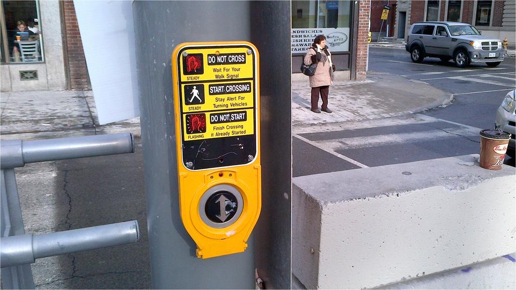
7 Preliminary Design for City of Hamilton LRT B-Line Signalling System Design 2.0 System Architecture and Operations 2.1 System Hardware The current design configuration assumes a localized 2-loop detector system operation, with provisions for future implementation of a centralized control and wireless communication system. For illustration purposes, a typical signal layout was designed for the intersection of Main Street West and Longwood Road South and is shown in Exhibit bit-1. The layout shows the LRT stops on the east side of the intersection serving both directions. The 2-loop (detector) system includes a Check-in detector and a Check-out detector. The 2-loop system may be implemented with a real time responsive programmable traffic controller with the Transit Signal Priority (TSP) function enabled. For the configuration in the eastbound direction, the Check-in detector is upstream of the intersection. For the westbound direction, the Check-in detector is upstream of the stop platform. In both directions, the Check-out detector is placed just downstream of the intersection to indicate passage of the LRV. The wiring diagram for the signal control is shown in Exhibit bit-2. Furthermore, Exhibit-3 shows more detail of the system. The diagram show location and sample of pedestrian push buttons used on similar system in Ontario (St. Clair LRT, Toronto). The pedestrian button is constantly emitting an audible signal to alert visually impaired patrons of the facility to prompt the signal controller. The tactile arrow direction alerts the patron of the direction of crossing once the audible chirps are activated. The final system configuration shall be designed in the next design phase. 2.2 System Operations The LRV will generally follow the posted speed which is 50 km/h for a majority of the route. The following signal parameters are also assumed for the preliminary design: All signals are fixed time actuated with TSP; Minimum Green for LRV= 7 sec; Clearance for LRV= 6 sec; TSP Priority Mode Options = Early Termination/Extension/Phase Omission (no phase omission for intersections with LRT stops; however advance left-turns can be skipped); Detection Type = Check-in/Check-out loop detectors; Cycle Times = 90 sec (majority of intersections); Advance left-turn phases can be skipped if there are no calls. Side-street phase omission may also be considered as part of the TSP priority scheme for intersections with no LRT stops, for more efficient operations. 2.3 Transit Signal Priority The purpose of the TSP is to achieve minimum run times for LRV through localized loop detection systems using Check-in and Check-out detectors. The system control is discussed in further detail in the attached memorandum in Appendix A. A In order to accommodate TSP, some changes were made to the existing intersections in terms of physical geometrics, traffic controls, and/or signal timings & phasings, as summarized in Appendix-B. Transit Priority can be achieved through several methods; Extension of the through-green phase (along the LRT alignment) or Early Termination of the cross-street phase after the minimum green or clearance is served. File: 2010 SNC-Lavalin Inc. All rights reserved 2 Confidential
8 Preliminary Design for City of Hamilton LRT B-Line Signalling System Design Phase omission can also be considered. Left-turn advance phases along the LRT alignment can be skipped if there are no calls. For intersections without LRT stops, cross-street phases can be skipped if there are no calls from vehicles or pedestrians. Phase insertion, such as LRT-only phase can also be considered. The exact strategy depends on the layout of the intersection and its interface with LRT alignment, and also the system in place. The purpose of the Check-in detector is to prepare the signal for an incoming LRV. It sends a signal to the controller to start the track green phase within a specified arrival time period. The Check-in detector should be placed far enough upstream of the intersection to allow for travel time to the stop-line, and if the stop is upstream of the intersection, the detector should allow for the dwell time, so there is enough time for initiating the track green phase before the LRV arrives. The signal initiates the track green phase after a specified time. In the case of intersections with LRV stops upstream of the intersection, as in the example provided in this report, the Check-in loop is placed upstream of the stop in the westbound direction. The exact dwell time for the stops will be calibrated in the field and will depend on the loading profile of the stop. Consequently, the Check-in detector will send the signal to the controller to start the track green phase after the dwell time and after all minimums and clearance times have been served. A LRV maximum green should also be defined to limit track green extensions beyond a reasonable length of time. Other considerations for TSP operations can include an All-red phase to account for when the LRV could be stalled across the intersection. Algorithm could be included in the single controller to identify such conditions, such as when the LRV clears the Check-in detector but does not reach the Check-out detector even after LRV maximum green (with extensions) is reached. A provision may be included to send an alarm to the control centre for such situations. Emergency vehicle pre-emption may also be included in the system design. TSP Scenarios The TSP algorithm is based on LRV detection at the Check-in loop and the state of the signal at that instance. After an approaching LRV is detected, depending on the state of the signal, a priority is provided by either extending the through-green with the LRV green running concurrently, or the early termination of the crossstreet green to provide LRV passage. If there are no LRV stops at the intersection then the cross-street phase can also be skipped to provide priority if there are no priority calls on the cross-street by either cars or pedestrians. The exact sequence and timing depends on the mode and direction of arrival and whether the LRV stops at the upstream station (downstream station will have no impact on signal operations). These scenarios and their respective TSP strategies are summarized in the following two exhibits. Exhibit-3 summarizes scenarios at intersections with LRT stops, such as the intersection of Main and Longwood which is illustrated here. Exhbit-4 summarizes scenarios for intersections without LRT stops. File: 2010 SNC-Lavalin Inc. All rights reserved 3 Confidential
9
10


11
12 Preliminary Design for City of Hamilton LRT B-Line Signalling System Design Exhibit-3: Example of TSP Scenarios for the Main/Longwood Stops 1 (e.g. far side stops) LRV Arrival Mode Scenario Longwood Road (Cross-street) Call Status Signal State at LRV Arrival Longwood Rd (Cross-street) Main St Through (Along LRT) LRT TSP Priority Options Road vehicle - Through Traffic LRT Phase phase 1 Cars waiting Red Green Red Extend Green Start LRT Green LRV approaches from the west on Main St (no LRT Stop) 2 No Cars waiting Red Green Red 3 Cars waiting Green Red Red Extend Green do not skip Cross-street Phase Early termination of Cross-street Green after pedestrian clearance time Start LRT Green Start LRT Green after Cross-street Clearance 4 Cars waiting Red Green Green Extend Green Extend LRT Green 5 No Cars waiting Red Green Green Extend Green and Skip Cross-street Phase Extend LRT Green LRV approaches from the east on Main St and stops at the Stop for at least 25 seconds before crossing the intersection Notes: 6 Cars waiting Red Green Red 7 No Cars waiting Red Green Red 8 Cars waiting Green Red Red 9 Cars waiting Red Green Green 10 No Cars waiting Red Green Green 1. Advance left-turn phase along LRT alignment can be skipped if there is no call 2. LRT phases are operated concurrently with through traffic 3. LRT phase terminates when Check-out detector is tripped Extend Green after 25 seconds delay Extend Green after 25 seconds delay and do not skip Cross-street Phase Call for early termination of Crossstreet Green within a 25 seconds delay and pedestrian clearance time Extend Green after 25 seconds delay Extend Green after 25 seconds delay and do not skip Cross-street Phase Start LRT Green after 25 seconds delay Start LRT Green after 25 seconds delay Start LRT Green after 25 seconds delay plus Cross-street clearance time Extend LRT Green after 25 seconds delay Extend LRT Green after 25 seconds delay 4. For early terminations, the minimum green and clearance times will be served before termination (such as pedestrian clearance time) 5. For purpose of illustration, it is assumed here that the LRV dwell time at the stop is 25 seconds. This time will be calibrated in the field and will depend on the loading profile at the Stop File: 2010 SNC-Lavalin Inc. All rights reserved 4 Confidential
 Through Traffic (along LRT) LRT Through Non- LRT Phase LRT Phase 1 Cars waiting Red Green Red Extend")


13 Preliminary Design for City of Hamilton LRT B-Line Signalling System Design Exhibit-4: TSP Scenarios for Intersections without LRT Stops Cross-street street Call Status Signal State at LRV Arrival TSP Priority Options LRV Arrival Mode Scenario Cross-street street (across LRT) Through Traffic (along LRT) LRT Through Non- LRT Phase LRT Phase 1 Cars waiting Red Green Red Extend Green Start LRT Green LRV approaches from either side (no LRT Stop) 2 No Cars waiting Red Green Red 3 Cars waiting Green Red Red Extend Green; and skip Cross-street Phase Early termination of Cross-street Green after pedestrian clearance time Start LRT Green Start LRT Green after Cross-street Clearance time 4 Cars waiting Red Green Green Extend Green Extend LRT Green Notes: 5 No Cars waiting Red Green Green 1. Advance left-turn phase along LRT alignment can be skipped if there is no call 2. LRT phases are operated concurrently with through traffic 3. LRT phase terminates when Check-out detector is tripped Extend Green; and skip Cross-street Phase Extend LRT Green 4. For early terminations, the minimum green and clearance times will be served before termination (such as pedestrian clearance time) The following Exhibit-5 illustrates two possible impacts of TSP on normal signal cycle. Exhibit-5 Impacts of TSP on Signal Cycle Normal Cycle (without TSP) Early Green Cycle (along LRT) Early Termination (for Cross-Street Street) Source: Light Rail Signal Priority, Skehan, S, LADOT, 2004 File: 2010 SNC-Lavalin Inc. All rights reserved 5 Confidential
14 Preliminary Design for City of Hamilton LRT B-Line Signalling System Design 3.0 Recommendations 3.1 Recommendations For intersections with no LRT stops, it is recommended that cross-street phases be skipped if required to adhere to LRV schedule, to allow for more efficient LRV priority and easier recovery to normal cycle. It should be noted that the current, initial, set-up does not distinguish between an LRV running on or behind schedule. This may be implemented in future. As mentioned previously, an all-red phase may be considered to alert the central office in case of LRV stalling across the intersection. This may be activated when an LRV does not reach the downstream check-out detector even after the maximum green (with extensions) is reached or after communications between the operator and central control to report the condition. It is suggested pedestrian detection systems be considered at intersections, especially at stop locations, to facilitate pedestrian crossings even when the pedestrian calls do not get activated for any reason. This will facilitate patrons of the system to arrive at the stop platform in a timely fashion. Emergency vehicle pre-empt can also be included in the system design. The following shall be considered in the detail design phase; pedestrian signals with call buttons for pedestrian coming out of the LRT stops toward the intersection cross walk should be considered at the boundary of the stop platform and the ramp to keep pedestrians from reaching the crosswalks until a walk signal on the crosswalk is activated. This walk signal will be synchronized with the crossing street walk signal. The purpose of this device is to force system patron alighting at the stop to wait on the stop platform rather than at the cross-walk in an unprotected environment. These additional pedestrian signals should not have audible chirps to avoid confusion with the crosswalk chirps. Crosswalk widths near LRT stops shall be revised in the next design phase in light of expected passenger volume loading at peak hour for pedestrian safety. Adaptive controllers can be considered for corridor-wide or system-wide optimization with the ability to reorder phase sequence. It is recommended to initiate a comprehensive before and after study to measure benefits of TSP on different levels of coverage, at local, corridor level and system level. It would also be important to choose appropriate Measures of Effectiveness (MOEs). For example it is recommended that delay be measured per person rather than per vehicle to measure benefits of LRT. Before and after collisions should also be monitored. File: 2010 SNC-Lavalin Inc. All rights reserved 6 Confidential
15 Preliminary Design for City of Hamilton LRT B-Line Signalling System Design Disclaimer This document contains the expression of the professional opinion of Steer Davies Gleave North America Inc. and/or its sub-consultants (hereinafter referred to collectively as the consultant team ) as to the matters set out herein, using their professional judgment and reasonable care. It is to be read in the context of the agreement (the Agreement ) between Steer Davies Gleave North America Inc. and the City of Hamilton (the Client ) for the Rapid Transit Preliminary Design and Feasibility Study (reference C ), and the methodology, procedures, techniques and assumptions used, and the circumstances and constraints under which its mandate was performed. This document is written solely for the purpose stated in the Agreement, and for the sole and exclusive benefit of the Client, whose remedies are limited to those set out in the Agreement. This document is meant to be read as a whole, and sections or parts thereof should thus not be read or relied upon out of context. The consultant team has, in preparing the Agreement outputs, followed methodology and procedures, and exercised due care consistent with the intended level of accuracy, using professional judgment and reasonable care. However, no warranty should be implied as to the accuracy of the Agreement outputs, forecasts and estimates. This analysis is based on data supplied by the client/collected by third parties. This has been checked whenever possible; however the consultant team cannot guarantee the accuracy of such data and does not take responsibility for estimates in so far as they are based on such data. Steer Davies Gleave North America Inc. disclaims any liability to the Client and to third parties in respect of the publication, reference, quoting, or distribution of this report or any of its contents to and reliance thereon by any third party. File: 2010 SNC-Lavalin Inc. All rights reserved Confidential
16 Preliminary Design for City of Hamilton LRT B-Line Signalling System Design Appendix A Concept of LRT system control for TSP File: 2010 SNC-Lavalin Inc. All rights reserved Confidential
17 LRT System Control 1.1 The following diagram provides an overview of the systems employed to control an urban LRT system and the interfaces with traffic intersections. The system shows an arrangement using centralised control. In place of centralised control, loop detection can be used using Prepare, Advance and Limit Line loops feeding into the LRT control system with local volt free contacts to the signal controller. 1.2 The following table details some of the scenarios that can be employed. Multiple scenarios can be used to provide different levels of priority at different times of the day. TABLE 1 PRIORITY SCENARIOS Scenario Vehicle Intersection 1 Vehicle A is identified approaching intersection, running on or behind schedule. LRT priority is requested from signal controller Signal phases are extended or cut short as appropriate (depending on travel time/distance of LRT from intersection) Signal controller can run clearance moves (where
18 left turns are on LRT track) LRT movement signalled, with priority given to LRT Signal controller compensates for lost time as required 2 Vehicle A is identified approaching intersection, running ahead of schedule. LRT Vehicle presence given to signal controller Signal phases are not extended or cut short Depending on point in signal cycle and desired programming, LRT receives standard LRT phase within the normal phase timing sequence. Signal controller can run clearance moves (where left turns are on LRT track) LRT movement signalled, LRT vehicle served in normal signal sequence, level of LRT delay therefore related to arrival point in signal cycle 3 Vehicle A is identified approaching intersection, running on or behind schedule. Vehicle B is identified on longer approach to intersection running on or behind schedule, with peak movement priority. Vehicle A s presence is not provided to Intersection if Vehicle B is detected within wider area When Vehicle B reached virtual loop, priority call placed for both LRT movements. LRT priority is requested from signal controller Signal phases are extended or cut short as appropriate (depending on travel time/distance of LRT from intersection) Signal controller can run clearance moves (where left turns are on LRT track) Both LRT movements signalled, with vehicle B given priority and vehicle A varying priority, depending on signal sequence (i.e. should the LRT movements be non-conflicting, then vehicle A could receive signal phase prior to vehicle B, or at least concurrently) Signal controller compensates for lost time as required 4 Vehicle A is identified approaching Vehicle A presence passed to signal controller
19 intersection, running on or behind schedule. Vehicle B is identified on longer approach to intersection running ahead of schedule, with peak movement priority. Vehicle B presence passed to signal controller (when it reaches virtual loop) Signal phases are not extended or cut short Depending on point in signal cycle and desired programming, LRT receives standard LRT phase within the normal phase timing sequence. Signal controller can run clearance moves (where left turns are on LRT track) LRT movement signalled, LRT vehicle served in normal signal sequence, level of LRT delay therefore related to arrival point in signal cycle If LRT Vehicle B is within a certain pre-set distance (or travel time), and the LRT movements are nonconflicting, the LRT Vehicle A signal would be extended to provide LRT Vehicle B a signal too If Vehicle B misses Vehicle A move, separate signalled move provided (as in Scenario 1 above). Signal Controller Logic The centralized control would provide inputs to the signal controller (via the LRT controller) therefore the centralized controller is making the decisions on when to pass inputs to the signal controller, essentially making the decisions on how to treat late-running versus early-running LRT vehicles, and any peak direction bias. As noted above, this function could also be provided by prepare, advance and limit line detector loops, although in this case, treatment of late-running versus early-running and peak directional bias would not be possible. The signal controller would therefore still carry out all functions of providing intersection control, including for LRT phases. The normal model of LRT operation would be to use the standard RBC controller, with LRT priority provided through the transit priority function within the intersection controller. For a typical intersection operation, as noted in the 4 scenarios above, LRT signal phases would be provided by the intersection controller by either:
20 I Using the transit priority function to extend/curtail/skip phases in order to minimise LRT delay I Using the normal phase sequence In both cases, the length of LRT phase would be controlled by the cancel loop, with the LRT phase only terminated once the cancel loop has detected the LRT vehicle Within the transit priority operation, certain parameters would be set at each intersection (on an individual intersection basis) to enable the maximum level of LRT priority to be provided, whilst maintaining a suitable level of intersection capacity for all other movements (this clearly includes the maintaining of all minimum green split and clearance periods). In this way, the normal sequence of phase appearance will generally be maintained, except for the potential skipping of less critical left-turn permitted phases phase green splits could vary each cycle depending on the appearance (or not) of LRT vehicles, but the intersection cycle time will generally be maintained over a number of cycles (where fixed cycle time operation is required for co-ordination with adjacent intersections). At a few particular intersections, the RBC pre-empt function could be used as an alternative to transit priority. In this case, LRT phases would be inserted at the next available opportunity (i.e. as soon as the current running timing period is able to terminate, subject to minima), rather than within the normal timing sequence. Within an urban environment, where the LRT alignment is street-running, the number of intersections that operate pre-empt LRT priority will be minimal, due to the considerations of maintaining co-ordination between adjacent intersections and ensuring pedestrian crossing movements are served when expected. System Integration The loops and vehicle detectors associated with the LRT system, including those used for the traffic signal system are in the majority of systems connected to the LRT control system. The LRT system provided voltage free feeds to the individual intersection controllers, usually from an adjacent equipment cabinet. All the signal heads, traffic and LRT are controlled from the intersection controller.
21 Preliminary Design for City of Hamilton LRT B-Line Signalling System Design Appendix-B Summary list of Intersections with traffic and timing assumptions along the corridor (Geometrics, Control and/or Signal Timings & Phasing) File: 2010 SNC-Lavalin Inc. All rights reserved Confidential
22 Node # New? Main Street Cross Street Geometric Assumptions Physical Signal Changes? Traffic and Timing Assumptions On LRT Alignment "Online" 41 Main Emerson No No changes to phasing (offline) 600a Yes Main Tram Stop Xing Ebnd Yes Simple 2-phase, LRT with main road 600b Yes Main Tram Stop Xing Wbnd Yes Simple 2-phase, LRT with main road 42 Main Bowman Yes No changes to phasing, LRT with main road 43 Main Dalewood Yes No changes to phasing, LRT with main road 44 Main Haddon Yes No changes to phasing, LRT with main road 45 Main Highway 403 Yes No changes to phasing, LRT with main road 46 Main Paisley No SBLT, No EBLT Yes No changes to phasing, LRT with main road 47 Main Longwood Yes No changes to phasing, LRT with main road 498 Yes Main Paradise Yes Simple 2-phase, LRT with main road 48 Main Macklin No EBLT Yes Simple 2-phase, LRT with main road 113 King Dundurn Extra free SBRT Yes Phase1 WBLT, Phase2 LRT, Phase3 NBLT, Phase4 SB, Phase6 WB, Phase8 NB 114 King Strathcona No WBLT Yes No changes to phasing, LRT with main road 115 King Locke Yes No changes to phasing, LRT with main road 1075 Yes King Pearl (No signal) No WBLT Yes Simple 2-phase, LRT with main road 117 King Queen Yes Phase1 LRT, Phase2 WB, Phase4 SB 118 King Hess Yes No changes to phasing, LRT with main road 119 King Caroline No WBLT Yes No changes to phasing, LRT with main road 120 King Bay Yes No changes to phasing, LRT with main road 121 King Summers Xing Yes No changes to phasing, LRT with main road 122 King MacNab Bus only WBLT Yes Simple 2-phase, LRT with main road, Buses WBLT yield to LRT 8 King James Bus only WBLT Yes No changes to phasing, LRT with main road, Buses WBLT yield to LRT 123 King Hughson Yes No changes to phasing, LRT with main road 124 King John Yes No changes to phasing, LRT with main road 125 King Catharine Yes Phase1 LRT, Phase2 WB, Phase4 SB 126 King Mary - Traffic Signals Removed 127 King Walnut - Traffic Signals Removed 128 King Ferguson Xing - Traffic Signals Removed 129 King Jarvis Xing - Traffic Signals Removed 130 King Wellington Yes Phase1 LRT and EB, Phase2 WB, Phase4 SB 603 Yes King West Yes Simple 2-phase, LRT with main road 131 King Victoria Yes No changes to phasing, LRT with main road 604 Yes King East No WBLT Yes Simple 2-phase, LRT with main road 132 King Emerald Yes Phase1 LRT and NSXing, Phase2 WB, (Phase 3 LRT alternative), Phase4 SB+NB 133 King Tisdale Yes Phase1 LRT and NSXing, Phase2 WB, (Phase 3 LRT alternative), Phase4 SB+NB 134 King Wentworth Yes Phase1 LRT and NSXing, Phase2 WB, (Phase 3 LRT alternative), Phase4 SB 135 King Sanford Yes No changes to phasing, LRT with main road 136 King Holton Yes Phase1 LRT and NSXing, Phase2 WB, (Phase 3 LRT alternative), Phase4 SB+NB 137 King Sherman Yes Phase2 WB, Phase3 LRT and NSXing, Phase4 SB+NB 605 Yes King Barnesdale Yes Phase2 WB, Phase3 LRT and NSXing, Phase4 SB+NB 138 King Melrose Yes Phase2 WB, Phase3 LRT and NSXing, Phase4 SB+NB 606 Yes King Balsam Yes Phase2 WB, Phase3 LRT and NSXing, Phase4 SB+NB 139 King Gage No WBLT Yes No changes to phasing, LRT with main road 607 Yes King Dunsmore Yes Simple 2-phase, LRT with main road 140 King Glendale No WBLT Yes No changes to phasing, LRT with main road 72 King Main Yes Phase1 NB, Phase2 WB+LRT, Phase3 West Xing, Phase4 EBUT 74 King Balmoral Xing No WBLT Yes No changes to phasing, LRT with main road 608 Yes King Grosvenor Yes Phase1 LRT and NSXing, Phase2 WB, (Phase 3 LRT alternative), Phase4 SB+NB 75 King Ottawa Yes Phase1 WBLT, Phase2 LRT, Phase4 NB, Phase6 WB, Phase8 SB 76 King Graham Yes Phase1 LRT and NSXing, Phase2 WB, (Phase 3 LRT alternative), Phase4 SB+NB 609 Yes King Tuxedo No WBLT Yes Simple 2-phase, LRT with main road 77 King Kenilworth Yes Phase1 WBLT, Phase2 LRT, Phase4 NB, Phase6 WB, Phase8 SB 78 King Cameron Xing No WBLT Yes No changes to phasing, LRT with main road 79 King Cope Yes No changes to phasing, LRT with main road 80 King Fairfield Xing Yes Simple 2-phase, LRT with main road 495 Yes King Queenston Yes Phase1 LRT, Phase2 SB Circulatory, Phase4 NB, Phase6 WB 82 Queenston Cochrane Yes Phase1 WBLT, Phase2 LRT, Phase4 NB, Phase6 WB 83 Queenston Walter No WBLT, No EBLT Yes Simple 2-phase, LRT with main road 84 Queenston Parkdale Yes Phase1 WBLT+EBLT, Phase2 EB+WB+LRT, Phase4 NB+SB 85 Queenston Reid No WBLT, No EBLT Yes Simple 2-phase, LRT with main road 86 Queenston RHVPWest Yes Phase1 EBLT, Phase2 EB+LRT, Phase4 SB, Phase6 EB 87 Queenston RHVP East Yes Phase1 EBLT, Phase2 EB+LRT, Phase4 NB, Phase6 EB 88 Queenston Woodman Yes Phase1 WBLT+EBLT, Phase2 EB+WB+LRT, Phase4 NB+SB 710 Queenston Queenston 575 Xing Yes Simple 2-phase, LRT with main road 89 Queenston Nash Yes Phase1 WBLT+EBLT, Phase2 EB+WB+LRT, Phase3 NBLT, Phase4 SB, Phase7 SBLT, Phase NB. Increase cycle time to 100" in AM+PM 90 Queenston Greenford Yes Phase1 WBLT+EBLT, Phase2 EB+WB+LRT, Phase4 NB+SB. Increase cycle time to 100" in AM+PM 611a Yes Queenston Tram Stop Xing Ebnd Yes Simple 2-phase, LRT with main road, Set cycle time to 100" in AM+PM 611b Yes Queenston Tram Stop Xing Wbnd Yes Simple 2-phase, LRT with main road, Set cycle time to 100" in AM+PM 91 Queenston Eastgate Mall No No changes to phasing (offline). Increase cycle time to 100" in AM+PM Off LRT Alignment ("Offline") 220 York Dundurn Extra WBLT lane Yes No changes to phasing (offline) 149 King Parkdale Yes Cycle time increase to 120" in PM 1043 Yes Parkdale Britannia Yes New traffic signal intersection. Simple 2-phase - Britannia Tragina No Stop signs only on side roads (currently 4-way Stop) - Britannia Fairfield No Stop signs only on side roads (currently 4-way Stop) - Britannia Normanhurst No Stop signs only on side roads (currently 4-way Stop) - Britannia Walter No Stop signs only on side roads (currently 4-way Stop) Notes 1." Phase 3 LRT alternative" - stage only operates if LRT present, thus allowing an LRT phase to be inserted either before or after both main and side road timing periods 2. All LT phases on main road of LRT alignment (phases #1 and #5) are always protected (and not permitted) 3. All LT movements across the LRT at intersections are protected (and not permitted) and do not operate simultaneously with the LRT - with the exception of nodes 122 and 8 where buses can yield
Transit City Etobicoke - Finch West LRT
 Delcan Corporation Transit City Etobicoke - Finch West LRT APPENDIX D Microsimulation Traffic Modeling Report March 2010 March 2010 Appendix D CONTENTS 1.0 STUDY CONTEXT... 2 Figure 1 Study Limits... 2
Jihong Cao, PE, Parsons Brinckerhoff Arnab Gupta, PE, Parsons Brinckerhoff Jay Yenerich, PE, Valley Metro
 Jihong Cao, PE, Parsons Brinckerhoff Arnab Gupta, PE, Parsons Brinckerhoff Jay Yenerich, PE, Valley Metro Outline Background Predictive Priority Algorithm Simulation Analysis Measure of Effectives (MOE)
MEMO. McCORMICK RANKIN CORPORATION. File FROM: Keyur Shah DATE: February 1, 2010 COPIES: OUR FILE: SUBJECT: TO:
 McCORMICK RANKIN CORPORATION 2655 North Sheridan Way Mississauga, Ontario, L5K 2P8 Tel: (905)823-8500 Fax: (905) 823-8503 E-mail: mrc@mrc.ca Website: www.mrc.ca MEMO TO: File FROM: Keyur Shah DATE: February
105 Toronto Street South, Markdale Transportation Impact Study. Paradigm Transportation Solutions Limited
 105 Toronto Street South, Markdale Transportation Impact Study Paradigm Transportation Solutions Limited December 2016 Project Summary Project Number 162060 December 2016 Client Zelinka Priamo Ltd 318
RTE. 1 at RTE. 637 & RTE. 639
 INTERSECTION SAFETY STUDY Prepared for: Virginia Department of Transportation Central Region Operations Traffic Engineering (UPC #81378, TO 12-092) DAVENPORT Project Number: 13-368 / /2014 RTE. 1 at RTE.
Location Concept Plan Amendment Recommendation Approved 2011 Concept Plan
 Valley Line West LRT Concept Plan Recommended Amendments Lewis Farms LRT Terminus Site Location Concept Plan Amendment Recommendation Approved 2011 Concept Plan Lewis Farms LRT terminus site, 87 Avenue/West
Craigieburn Employment Precinct North and English Street
 Craigieburn Employment Precinct North and English Street METROPOLITAN PLANNING AUTHORITY Intersection Analyses 7 February 2014 Intersection Analyses Craigieburn Employment Precinct North and English Street
Downtown One Way Street Conversion Technical Feasibility Report
 Downtown One Way Street Conversion Technical Feasibility Report As part of the City s Transportation Master Plan, this report reviews the technical feasibility of the proposed conversion of the current
CITY OF HAMILTON PLANNING AND ECONOMIC DEVELOPMENT DEPARTMENT Light Rail Transit Office
 CITY OF HAMILTON PLANNING AND ECONOMIC DEVELOPMENT DEPARTMENT Light Rail Transit Office TO: Mayor and Members General Issues Committee COMMITTEE DATE: March 28, 2017 SUBJECT/REPORT NO: WARD(S) AFFECTED:
V. DEVELOPMENT OF CONCEPTS
 Martin Luther King, Jr. Drive Extension FINAL Feasibility Study Page 9 V. DEVELOPMENT OF CONCEPTS Throughout the study process several alternative alignments were developed and eliminated. Initial discussion
King County Metro. Columbia Street Transit Priority Improvements Alternative Analysis. Downtown Southend Transit Study. May 2014.
 King County Metro Columbia Street Transit Priority Improvements Alternative Analysis Downtown Southend Transit Study May 2014 Parametrix Table of Contents Introduction... 1 Methodology... 1 Study Area...
Craig Scheffler, P.E., PTOE HNTB North Carolina, P.C. HNTB Project File: Subject
 TECHNICAL MEMORANDUM To Kumar Neppalli Traffic Engineering Manager Town of Chapel Hill From Craig Scheffler, P.E., PTOE HNTB North Carolina, P.C. Cc HNTB Project File: 38435 Subject Obey Creek TIS 2022
RE: A Traffic Impact Statement for a proposed development on Quinpool Road
 James J. Copeland, P.Eng. GRIFFIN transportation group inc. 30 Bonny View Drive Fall River, NS B2T 1R2 May 31, 2018 Ellen O Hara, P.Eng. Project Engineer DesignPoint Engineering & Surveying Ltd. 200 Waterfront
Interstate Operations Study: Fargo-Moorhead Metropolitan Area Simulation Results
 NDSU Dept #2880 PO Box 6050 Fargo, ND 58108-6050 Tel 701-231-8058 Fax 701-231-6265 www.ugpti.org www.atacenter.org Interstate Operations Study: Fargo-Moorhead Metropolitan Area 2025 Simulation Results
TRANSPORTATION REVIEW
 TRANSPORTATION REVIEW - PROPOSED MIX OF LAND USES IS CONSISTENT WITH THE CITY S UNDER THE GRANVILLE BRIDGE POLICIES THAT AIM TO MEET NEIGHBOURING RESIDENTS SHOPPING NEEDS AND REDUCE RELIANCE ON AUTOMOBILE
IMPROVEMENT CONCEPTS
 IMPROVEMENT CONCEPTS for the South Novato Transit Hub Study Prepared by: January 11, 2010 DKS Associates With Wilbur Smith Associates IMPROVEMENT CONCEPTS Chapter 1: Introduction 1. INTRODUCTION The strategic
To: File From: Adrian Soo, P. Eng. Markham, ON File: Date: August 18, 2015
 Memo To: From: Adrian Soo, P. Eng. Markham, ON : 165620021 Date: Reference: E.C. Row Expressway, Dominion Boulevard Interchange, Dougall Avenue Interchange, and Howard 1. Review of Interchange Geometry
Technical Memorandum. To: From: Date: October 14 th, 2018 Project #: 1302 Project Name: Subject: Distribution:
 Technical Memorandum To: Tom Hanrahan Jeff Sharp From: Date: October 14 th, 2018 Project #: 1302 Project Name: Subject: Distribution: Barrie Lockhart Road LP Conformity Review Scott Young Sorbara Group
Interstate Operations Study: Fargo-Moorhead Metropolitan Area Simulation Output
 NDSU Dept #2880 PO Box 6050 Fargo, ND 58108-6050 Tel 701-231-8058 Fax 701-231-6265 www.ugpti.org www.atacenter.org Interstate Operations Study: Fargo-Moorhead Metropolitan Area 2015 Simulation Output Technical
TORONTO TRANSIT COMMISSION REPORT NO.
 Form Revised: February 2005 TORONTO TRANSIT COMMISSION REPORT NO. MEETING DATE: May 28, 2009 SUBJECT: DON MILLS STATION ACTION ITEM RECOMMENDATIONS It is recommended that the Commission: 1. Endorse the
TIMBERVINE TRANSPORTATION IMPACT STUDY FORT COLLINS, COLORADO JANUARY Prepared for:
 TIMBERVINE TRANSPORTATION IMPACT STUDY FORT COLLINS, COLORADO JANUARY 2014 Prepared for: Hartford Companies 1218 W. Ash Street Suite A Windsor, Co 80550 Prepared by: DELICH ASSOCIATES 2272 Glen Haven Drive
4.0 TIER 2 ALTERNATIVES
 4.0 TIER 2 ALTERNATIVES The Tier 2 Alternatives represent the highest performing Tier 1 Alternatives. The purpose of the Tier 2 Screening was to identify the LPA utilizing a more robust list of evaluation
Recommended Vision for the Downtown Rapid Transit Network
 Recommended Vision for the Downtown Rapid Transit Network April 2008 Presentation Overview Context Transit options Assessment of options Recommended network Building the network 2 1 Rapid Our Vision Reliable
Sound Transit East Link: Bus/LRT System Integration Study
 Sound Transit East Link: Bus/LRT System Integration Study Prepared For: Sound Transit King County Metro Mercer Island WSDOT Prepared By: CH2M HILL July, 2014 1 SOUND TRANSIT EAST LINK: BUS/LRT SYSTEMES
Continued coordination and facilitation with City of Austin staff on documentation of processes to permit construction activities at the site.
 Project Manager Ed Collins LJA Engineering, Inc. Transportation Planning Manager 5316 Highway 290 West Austin Public Infrastructure Group Austin, TX 78735 (512) 762-6301 cell (512) 439-4757 office CARTS
EXECUTIVE SUMMARY. The following is an outline of the traffic analysis performed by Hales Engineering for the traffic conditions of this project.
 EXECUTIVE SUMMARY This study addresses the traffic impacts associated with the proposed Shopko redevelopment located in Sugarhouse, Utah. The Shopko redevelopment project is located between 1300 East and
TORONTO TRANSIT COMMISSION REPORT NO.
 Form Revised: February 2005 TORONTO TRANSIT COMMISSION REPORT NO. MEETING DATE: October 24, 2012 SUBJECT: DOWNTOWN RAPID TRANSIT EXPANSION STUDY (DRTES) PHASE 1 STRATEGIC PLAN ACTION ITEM RECOMMENDATIONS
RICHMOND OAKS HEALTH CENTRE 6265 PERTH STREET OTTAWA, ONTARIO TRANSPORTATION BRIEF. Prepared for: Guycoki (Eastern) Limited.
 Limited.") RICHMOND OAKS HEALTH CENTRE 6265 PERTH STREET OTTAWA, ONTARIO TRANSPORTATION BRIEF Prepared for: Guycoki (Eastern) Limited June 16, 2016 116-638 Brief_1.doc D. J. Halpenny & Associates Ltd. Consulting
RICHMOND OAKS HEALTH CENTRE 6265 PERTH STREET OTTAWA, ONTARIO TRANSPORTATION BRIEF Prepared for: Guycoki (Eastern) Limited June 16, 2016 116-638 Brief_1.doc D. J. Halpenny & Associates Ltd. Consulting
AVERAGE DELAY PER VEHICLE EXISTING CONDITIONS AND NO BUILD ALTERNATIVE
 AVERAGE DELAY PER VEHICLE EXISTING CONDITIONS AND NO BUILD ALTERNATIVE EXISTING CONDITIONS (1) NO BUILD ALTERNATIVE () Compared to existing conditions Peak Hour/Train Scenario No Train 1 With Train No
TRAFFIC IMPACT STUDY. USD #497 Warehouse and Bus Site
 TRAFFIC IMPACT STUDY for USD #497 Warehouse and Bus Site Prepared by: Jason Hoskinson, PE, PTOE BG Project No. 16-12L July 8, 216 145 Wakarusa Drive Lawrence, Kansas 6649 T: 785.749.4474 F: 785.749.734
Spadina Subway Extension Downsview Station to Steeles Avenue Environmental Assessment
 Spadina Subway Extension Downsview Station to Steeles Avenue Environmental Assessment APPENDIX Q SUBWAY OPERATIONS REPORT Spadina Subway Extension Downsview Station to Steeles Avenue Environmental Assessment
Mr. Kyle Zimmerman, PE, CFM, PTOE County Engineer
 Los Alamos County Engineering Division 1925 Trinity Drive, Suite B Los Alamos, NM 87544 Attention: County Engineer Dear Kyle: Re: NM 502 Transportation Corridor Study and Plan Peer Review Los Alamos, New
886 March Road McDonald's Transportation Study
 McDonald's Restaurants of Canada Limited March 2013 886 March Road McDonald's Transportation Study Submitted by: HDR Corporation 100 York Boulevard, Suite 300 Richmond Hill, ON L4B 1J8 (905) 882-4100 www.hdrinc.com
GTA West Corridor Planning and EA Study Stage 1
 GTA West Corridor Planning and EA Study Stage 1 Draft Development Strategy Presentation to Peel Goods Movement Task Force April 8 2011 Study Areas 2 Unique Approach Unprecedented two-stage EA process:
Pembina Emerson Border Crossing Interim Measures Microsimulation
 Pembina Emerson Border Crossing Interim Measures Microsimulation Final Report December 2013 Prepared for: North Dakota Department of Transportation Prepared by: Advanced Traffic Analysis Center Upper Great
TRAFFIC IMPACT STUDY FOR ST. JOSEPH'S ELEMENTARY SCHOOL ADDITION
 CATHOLIC DISTRICT SCHOOL BOARD OF EASTERN ONTARIO P.O. 61992 TRAFFIC IMPACT STUDY FOR ST. JOSEPH'S ELEMENTARY SCHOOL ADDITION SEPTEMBER 5, 218 TRAFFIC IMPACT STUDY FOR ST. JOSEPH'S ELEMENTARY SCHOOL ADDITION
Appendix B: Travel Demand Forecasts July 2017
 Appendix B: Travel Demand Forecasts July 2017 Table of Contents 1 Introduction... 2 2 Model Review and Updates... 2 2.1 Overview of Smart Moves Model ( City of London Model )... 2 2.1.1 Network and Zone
I-20 EAST TRANSIT INITIATIVE Tier 1 and Tier 2 Alternatives Screening Report EXECUTIVE SUMMARY
 EXECUTIVE SUMMARY The purpose of this report is to document the results of the Tier 1 and Tier 2 Screening of alternatives for the I-20 East Transit Initiative. The two-tier screening process presented
GASOLINE SERVICE STATION 1618, 1622 ROGER STEVENS DRIVE OTTAWA, ONTARIO TRANSPORTATION IMPACT ASSESSMENT. Prepared for:
 GASOLINE SERVICE STATION 1618, 1622 ROGER STEVENS DRIVE OTTAWA, ONTARIO TRANSPORTATION IMPACT ASSESSMENT Prepared for: Invecta Development (Ottawa) Corporation 758 Shanks Height Milton, ON L9T 7P7 May
Clean Harbors Canada, Inc.
 Clean Harbors Canada, Inc. Proposed Lambton Landfill Expansion Environmental Assessment Terms of Reference Transportation Assessment St. Clair Township, Ontario September 2009 itrans Consulting Inc. 260
City of Pacific Grove
 Regional Study Utilizing Caltrans Intersection Evaluation Section 7: City of Pacific Grove s: FIRST STREET AT CENTRAL AVENUE Transportation Agency for Monterey County Prepared by Transportation Agency
BARRHAVEN FELLOWSHIP CRC 3058 JOCKVALE ROAD OTTAWA, ONTARIO TRANSPORTATION BRIEF. Prepared for:
 BARRHAVEN FELLOWSHIP CRC 3058 JOCKVALE ROAD OTTAWA, ONTARIO TRANSPORTATION BRIEF Prepared for: Barrhaven Fellowship CRC 3058 Jockvale Road Ottawa, ON K2J 2W7 December 7, 2016 116-649 Report_1.doc D. J.
Department of Civil Engineering The University of British Columbia. Nicolas Saunier
 Department of Civil Engineering The University of British Columbia TRUCK SIGNAL PRIORITY Nicolas Saunier Wook Kang Why Truck Priority? Reduce Rd the Cost of Goods Transportation Reduce Red Light Running
FINAL. Sound Transit Long-Range Plan Update. Issue Paper S.1: Tacoma Link Integration with Central Link. Prepared for: Sound Transit
 Sound Transit Long-Range Plan Update Issue Paper S.1: Tacoma Link Integration with Central Link Prepared for: Sound Transit Prepared by: Quade & Douglas, Inc. FINAL March 2005 Foreword This issue paper
West Hills Shopping Centre Lowe s Expansion Traffic Impact Study
 West Hills Shopping Centre Lowe s Expansion Traffic Impact Study Prepared for: Armel Corporation January 2015 Paradigm Transportation Solutions Ltd. 22 King Street South, Suite 300 Waterloo ON N2J 1N8
Escondido Marriott Hotel and Mixed-Use Condominium Project TRAFFIC IMPACT ANALYSIS REPORT
 Escondido Marriott Hotel and Mixed-Use Condominium Project TRAFFIC IMPACT ANALYSIS REPORT Prepared for Phelps Program Management 420 Sixth Avenue, Greeley, CO 80632 Prepared by 5050 Avenida Encinas, Suite
The Engineering Department recommends Council receive this report for information.
 CORPORATE REPORT NO: R161 COUNCIL DATE: July 23, 2018 REGULAR COUNCIL TO: Mayor & Council DATE: July 19, 2018 FROM: General Manager, Engineering FILE: 8740-01 SUBJECT: Surrey Long-Range Rapid Transit Vision
MERIVALE PRIORITY SQUARE 2852 MERIVALE ROAD CITY OF OTTAWA TRANSPORTATION BRIEF. Prepared for: ONT Inc. 25 Winding Way Nepean, Ontario K2C 3H1
 MERIVALE PRIORITY SQUARE 2852 MERIVALE ROAD CITY OF OTTAWA TRANSPORTATION BRIEF Prepared for: 2190986ONT Inc. 25 Winding Way Nepean, Ontario K2C 3H1 October 6, 2010 110-502 Report_1.doc D. J. Halpenny
TRAFFIC IMPACT STUDY DERRY GREEN CORPORATE BUSINESS PARK MILTON SECONDARY PLAN MODIFICATION
 TRAFFIC IMPACT STUDY DERRY GREEN CORPORATE BUSINESS PARK MILTON SECONDARY PLAN MODIFICATION TRAFFIC IMPACT STUDY DERRY GREEN CORPORATE BUSINESS PARK MILTON SECONDARY PLAN MODIFICATION DECEMBER 24 UPDATED
ANDERSON PROPERTY SITE ANALYSIS
 ANDERSON PROPERTY SITE ANALYSIS Introduction The Montgomery County Department of Transportation (MCDOT) initiated a feasibility study in the fall of 2012 to evaluate the need for transit service expansion
TRAFFIC SIGNAL DESIGN REPORT KING OF PRUSSIA ROAD & RAIDER ROAD RADNOR TOWNSHIP PENNSYLVANIA
 TRAFFIC SIGNAL DESIGN REPORT KING OF PRUSSIA ROAD & RAIDER ROAD RADNOR TOWNSHIP PENNSYLVANIA PREPARED FOR: UNIVERSITY OF PENNSYLVANIA HEALTH SYSTEM 34 CIVIC CENTER BOULEVARD PHILADELPHIA, PA 1987 (61)
LAWRENCE TRANSIT CENTER LOCATION ANALYSIS 9 TH STREET & ROCKLEDGE ROAD / 21 ST STREET & IOWA STREET LAWRENCE, KANSAS
 LAWRENCE TRANSIT CENTER LOCATION ANALYSIS 9 TH STREET & ROCKLEDGE ROAD / 21 ST STREET & IOWA STREET LAWRENCE, KANSAS TRAFFIC IMPACT STUDY FEBRUARY 214 OA Project No. 213-542 TABLE OF CONTENTS 1. INTRODUCTION...
Traffic Impact Study Proposed Residential Development (Watson Parkway North - Starwood Drive Node, City of Guelph)
") Traffic Impact Study Proposed Residential Development (Watson Parkway North - Starwood Drive Node, City of Guelph) Prepared By: 332 Lorne Avenue East Stratford ON N5A 6S4 Prepared for: Paul Kemper, President
Traffic Impact Study Proposed Residential Development (Watson Parkway North - Starwood Drive Node, City of Guelph) Prepared By: 332 Lorne Avenue East Stratford ON N5A 6S4 Prepared for: Paul Kemper, President
Appendix C-5: Proposed Refinements Rail Operations and Maintenance Facility (ROMF) Traffic Impact Analysis. Durham-Orange Light Rail Transit Project
 Traffic Impact Analysis. Durham-Orange Light Rail Transit Project") Appendix C-5: Proposed Refinements Rail Operations and Maintenance Facility (ROMF) Traffic Impact Analysis Durham-Orange Light Rail Transit Project July 25, 218 ROMF Transportation Impact Analysis Version
Appendix C-5: Proposed Refinements Rail Operations and Maintenance Facility (ROMF) Traffic Impact Analysis Durham-Orange Light Rail Transit Project July 25, 218 ROMF Transportation Impact Analysis Version
August 26, Main-McVay Transit Study Stakeholder Advisory Committee. John Evans, LTD David Reesor, City of Springfield
 August 26, 2014 TO: FROM: RE: Main-McVay Transit Study Stakeholder Advisory Committee John Evans, LTD David Reesor, City of Springfield Range of Possible Transit Solutions At the July 29, 2014 Stakeholder
West LRT. Alignment Update and Costing Report May Calgary Transit Transportation Planning Clifton ND Lea Consultants
 West LRT Alignment Update and Costing Report 2006 May Calgary Transit Transportation Planning Clifton ND Lea Consultants West LRT Update Background The service area for West LRT is generally described
Note: The October 2007 version of this report has been updated in this December 2008 report to present costs in year 2007 dollars.
 Sound Transit Phase 2 South Corridor LRT Design Report: SR 99 and I-5 Alignment Scenarios (S 200 th Street to Tacoma Dome Station) Tacoma Link Extension to West Tacoma Prepared for: Sound Transit Prepared
MEMO. McCORMICK RANKIN CORPORATION. File Mark VanderSluis, Keyur Shah DATE: October 26, 2009 COPIES: OUR FILE: TO: FROM: Jack Thompson
 McCORMICK RANKIN CORPORATION 2655 North Sheridan Way Mississauga, Ontario, L5K 2P8 Tel: (95)823-85 Fax: (95) 823-853 E-mail: mrc@mrc.ca Website: www.mrc.ca MEMO TO: FROM: File Mark VanderSluis, Keyur Shah
3.15 SAFETY AND SECURITY
 3.15 SAFETY AND SECURITY Introduction This section describes the environmental setting and potential effects of the alternatives analyzed in this EIR with regard to safety and security in the SantaClara-Alum
STRATEGIC PRIORITIES AND POLICY COMMITTEE MAY 5, 2016
 STRATEGIC PRIORITIES AND POLICY COMMITTEE MAY 5, 2016 Shift Rapid Transit Initiative Largest infrastructure project in the city s history. Rapid Transit initiative will transform London s public transit
MEMORANDUM. Figure 1. Roundabout Interchange under Alternative D
 MEMORANDUM Date: To: Liz Diamond, Dokken Engineering From: Subject: Dave Stanek, Fehr & Peers Western Placerville Interchanges 2045 Analysis RS08-2639 Fehr & Peers has completed a transportation analysis
Key Transfer Stations - Technical Memo
 DOCUMENT 5 October 2008 Key - Technical Memo 1.0 INTRODUCTION In May 2008 Council approved a Primary Rapid Transit Network which includes both Light Rail Transit (LRT) and Bus Rapid Transit (BRT) corridors.
Proposed Inn at Bellefield Traffic Impact Assessment
 Proposed Inn at Bellefield Traffic Impact Assessment Town of Hyde Park Dutchess County, New York Prepared for: T-Rex Hyde Park Owner LLC 500 Mamroneck Avenue, Suite 300 Harrison, NY 10528 June 21, 2017
Proposed location of Camp Parkway Commerce Center. Vicinity map of Camp Parkway Commerce Center Southampton County, VA
 Proposed location of Camp Parkway Commerce Center Vicinity map of Camp Parkway Commerce Center Southampton County, VA Camp Parkway Commerce Center is a proposed distribution and industrial center to be
DEVELOPMENT PROPERTY 1627 MAXIME STREET CITY OF OTTAWA TRANSPORTATION OVERVIEW. Prepared for: Subhas Bhargava. July 9, Overview_1.
 DEVELOPMENT PROPERTY 1627 MAXIME STREET CITY OF OTTAWA TRANSPORTATION OVERVIEW Prepared for: Subhas Bhargava July 9, 2015 115-620 Overview_1.doc D. J. Halpenny & Associates Ltd. Consulting Transportation
MILLERSVILLE PARK TRAFFIC IMPACT ANALYSIS ANNE ARUNDEL COUNTY, MARYLAND
 MILLERSVILLE PARK TRAFFIC IMPACT ANALYSIS ANNE ARUNDEL COUNTY, MARYLAND Prepared for: Department of Public Works Anne Arundel County Prepared by: URS Corporation 4 North Park Drive, Suite 3 Hunt Valley,
RESPONSE TO TRAFFIC IMPACT STUDY COMMENTS
 RESPONSE TO TRAFFIC IMPACT STUDY COMMENTS Proposed Gas Station 40 Arthur Street (Highway 26), Town of the Blue Mountains (Thornbury), County of Grey, Ontario AUGUST 2013 August 27, 2013 MR. REG RUSSWURM
Mr. Vince Mauceri General Manager Transportation Operations and Technology
 Mr. Vince Mauceri General Manager Transportation Operations and Technology METROLINX OVERVIEW AND MANDATE Established in 2006 to address the significant transportation challenges in the Greater Toronto
Error! Reference source not found.
 shown in Error! Reference source not found..5. Four scenarios are shown representing the AM and PM peak periods for the current status quo of traffic and the 2011 projected traffic with all of the public
PROJECT: Wilkinson Road Corridor Improvement Traffic Management Planning Project SUBJECT: Traffic Analysis
 TECHNICAL MEMORANDUM DATE: September 10, 2014 PROJECT 5861.03 NO: PROJECT: Wilkinson Road Corridor Improvement Traffic Management Planning Project SUBJECT: Traffic Analysis TO: Steve Holroyd - District
5. OPPORTUNITIES AND NEXT STEPS
 5. OPPORTUNITIES AND NEXT STEPS When the METRO Green Line LRT begins operating in mid-2014, a strong emphasis will be placed on providing frequent connecting bus service with Green Line trains. Bus hours
Attachment 5 Eglinton West LRT Planning and Technical Update
 Eglinton West LRT Planning and Technical Update 1. Introduction In July 2016, City Council approved an Eglinton West LRT with between 8 and 12 stops between Mount Dennis and Renforth Gateway, and up to
Bi-County Transitway/ Bethesda Station Access Demand Analysis
 Bi-County Transitway/ Bethesda Station Access Demand Analysis Prepared for: Washington Metropolitan Area Transit Authority Office of Planning and Project Development May 2005 Prepared by: in conjunction
Date: February 7, 2017 John Doyle, Z-Best Products Robert Del Rio. T.E. Z-Best Traffic Operations and Site Access Analysis
 Memorandum Date: February 7, 07 To: From: Subject: John Doyle, Z-Best Products Robert Del Rio. T.E. Z-Best Traffic Operations and Site Access Analysis Introduction Hexagon Transportation Consultants, Inc.
MINERVA PARK SITE TRAFFIC IMPACT STUDY M/I HOMES. September 2, 2015
 5500 New Albany Road Columbus, Ohio 43054 Phone: 614.775.4500 Fax: 614.775.4800 Toll Free: 1-888-775-EMHT emht.com 2015-1008 MINERVA PARK SITE TRAFFIC IMPACT STUDY M/I HOMES September 2, 2015 Engineers
Table 8-1: Service Frequencies for All Short-List Alternatives by Day of Week and Time of Day Frequency Day of Week Time of Day Time Period
 8. Operating Plans The following Section presents the operating plans for the Short-List Alternatives. The modern streetcar operating plans are presented for Alternatives 2 and 3, followed by bus rapid
Re: Residential Development - Ogilvie/Cummings Transportation Overview
 1223 Michael Street, Suite 100, Ottawa, ON K1J 7T2 Tel: 613.738.4160 Fax: 613.739.7105 www.delcan.com March 28, 2012 OUR REF: TO3088TOY Barry J. Hobin & Architects 63 Pamilla Street Ottawa, ON K1S 3K7
TRAFFIC IMPACT ANALYSIS
 TRAFFIC IMPACT ANALYSIS Emerald Isle Commercial Development Prepared by SEPI Engineering & Construction Prepared for Ark Consulting Group, PLLC March 2016 I. Executive Summary A. Site Location The Emerald
INTERSECTION ANALYSIS PARK AVENUE AND BRADDOCK ROAD (FROSTBURG, MD) FOR LENHART TRAFFIC CONSULTING, INC.
 FOR LENHART TRAFFIC CONSULTING, INC.") INTERSECTION ANALYSIS FOR PARK AVENUE AND BRADDOCK ROAD (FROSTBURG, MD) Prepared for: City of Frostburg, Maryland & Allegany County Commissioners Prepared by: LENHART TRAFFIC CONSULTING, INC. TRAFFIC ENGINEERING
INTERSECTION ANALYSIS FOR PARK AVENUE AND BRADDOCK ROAD (FROSTBURG, MD) Prepared for: City of Frostburg, Maryland & Allegany County Commissioners Prepared by: LENHART TRAFFIC CONSULTING, INC. TRAFFIC ENGINEERING
Tunney s Pasture to Dominion Station Traffic and Transit Detours. April 4, 2017 C. Wheeler/ C. Swail
 Tunney s Pasture to Dominion Station Traffic and Transit Detours April 4, 2017 C. Wheeler/ C. Swail Purpose of Presentation Outline key principles for traffic and transit management Implementation strategies
2.0 Development Driveways. Movin Out June 2017
 Movin Out June 2017 1.0 Introduction The proposed Movin Out development is a mixed use development in the northeast quadrant of the intersection of West Broadway and Fayette Avenue in the City of Madison.
Letter EL652 City of Mercer Island. Page 1. No comments n/a
 Letter EL652 City of Mercer Island Page 1 No comments n/a Page 2 Response to comment EL652 1 Section 4.5.3 of the Final EIS presents the range of potential impacts of the project. This project also lists
Metro Transit Arterial Transitway Corridors Study
 Metro Transit Arterial Transitway Corridors Study Technical Memorandum #3 Corridor Mode Development 2/1/2012 Prepared by the SRF Consulting Group Team Table of Contents Introduction... 1 Concept Plans...
South Lexington Transportation Study Lexington, Massachusetts
 South Lexington Transportation Study Lexington, Massachusetts Preliminary Findings and Options for Consideration Businesses Meeting 10/10/13 Town of Lexington Engineering and Planning Departments Meeting
Application of Autonomous Driving Technology to Transit - Functional Capabilities for Safety and Capacity
 Application of Autonomous Driving Technology to Transit - Functional Capabilities for Safety and Capacity Presentation to Federal Transit Administration and American Public Transportation Association July
TRAFFIC DATA. Existing Derousse Ave./River Rd. AM LOS Analysis Existing Derousse Ave./River Rd. PM LOS Analysis
 Appendix E NJ TRANSIT Pennsauken Junction Transit Center and Park & Ride RiverLINE and Atlantic City Line Pennsauken Township, Camden County, New Jersey TRAFFIC DATA Background Traffic Information for
County State Aid Highway 30 (Diffley Road) and Dodd Road Intersection Study
 and Dodd Road Intersection Study") County State Aid Highway 30 (Diffley Road) and Dodd Road Intersection Study City of Eagan, Dakota County, Minnesota Date: March 2012 Project No. 14957.000 444 Cedar Street, Suite 1500 Saint Paul, MN 55101
County State Aid Highway 30 (Diffley Road) and Dodd Road Intersection Study City of Eagan, Dakota County, Minnesota Date: March 2012 Project No. 14957.000 444 Cedar Street, Suite 1500 Saint Paul, MN 55101
Option 2 - Convert to Automatic Train Control (ATC) Signalling Technology
 Signalling Technology") Option 2 - Convert to Automatic Train Control (ATC) Signalling Technology Option 2 is substantially different from the previous options, in that replacement of the existing signalling system, rather than
Option 2 - Convert to Automatic Train Control (ATC) Signalling Technology Option 2 is substantially different from the previous options, in that replacement of the existing signalling system, rather than
8 Evaluation. Sacramento Intermodal Transportation Facility Technical Report #13 Intermodal Alternatives Study. City of Sacramento
 8 Evaluation Figure 8.1 SITF Design Charrette with City of Sacramento Staff and SMWM/Arup. 8.1 Site Planning and Architecture The two options present completely different site strategies: The Move the
City of Marina. Regional Roundabout Study Utilizing Caltrans Intersection Control Evaluation Section 4: Transportation Agency for Monterey County
 Regional Roundabout Study Utilizing Caltrans Intersection Control Evaluation Section 4: City of Marina Study Intersections: RESERVATION ROAD AT BEACH ROAD RESERVATION ROAD AT DEFOREST ROAD CARDOZA AVENUE
I-290 Phase I Study Summary of NFPA-130 Analysis of Proposed CTA Station Platform Widths May 2016
 I-290 Phase I Study Summary of NFPA-130 Analysis of Proposed CTA Station Platform Widths May 2016 INTRODUCTION As part of the I-290 reconstruction phase I study, IDOT has coordinated with the CTA regarding
Addendum No. 2 to Supplemental Environmental Impact Statement/ Supplemental Environmental Impact Report
 Addendum No. 2 to Supplemental Environmental Impact Statement/ Supplemental Environmental Impact Report REMARKS Addendum Date: Case No.: 1996.281E_13 Project Title: - Phase 2 of the Third Street Light
Service and Operations Planning for Ottawa s New Light Rail Line Pat Scrimgeour
 Service and Operations Planning for Ottawa s New Light Rail Line Pat Scrimgeour Manager, Transit Service Planning and Reporting OC Transpo Ottawa, Ontario Ottawa Light Rail Project 12.5 km, 13 stations
APPENDIX E. Traffic Analysis Report
 APPENDIX E Traffic Analysis Report THIS PAGE INTENTIONALLY BLANK EAGLE RIVER TRAFFIC MITIGATION PHASE I OLD GLENN HIGHWAY/EAGLE RIVER ROAD INTERSECTION IMPROVEMENTS TRAFFIC ANALYSIS Eagle River, Alaska
Tunney s Pasture Station Bus Loop and Lay-up Area Design
 2017 Canadian Consulting Engineer Award Submission Tunney s Pasture Station Bus Loop and Lay-up Area Design Presented to: Canadian Consulting Engineer 80 Valleybrook Drive Toronto, Ontario M3B 2S9 April
CTfastrak Expansion. Stakeholder Meeting #4 Manchester Town Hall June 3, 2016
 CTfastrak Expansion Stakeholder Meeting #4 Manchester Town Hall June 3, 2016 Today s Agenda Phase I Update 2016 Service Plan Implementation Schedule & Cost Update Phase II Services Timeline Market Analysis
Table 1 - Land Use Comparisons - Proposed King s Wharf Development. Retail (SF) Office (SF) 354 6,000 10, Land Uses 1
 Office (SF) 354 6,000 10, Land Uses 1") Ref. No. 171-6694 Phase 2 November 23, 217 Mr. David Quilichini, Vice President Fares & Co. Developments Inc. 31 Place Keelson Sales Centre DARTMOUTH NS B2Y C1 Sent Via Email to David@faresinc.com RE:
Ref. No. 171-6694 Phase 2 November 23, 217 Mr. David Quilichini, Vice President Fares & Co. Developments Inc. 31 Place Keelson Sales Centre DARTMOUTH NS B2Y C1 Sent Via Email to David@faresinc.com RE:
144&176 John St. and 200 John St. & 588 Charlotte St. Hotel and Residential Subdivision Development
 Solmar Development Corp. 144&176 John St. and 2 John St. & 588 Charlotte St. Hotel and Residential Subdivision Development TRANSPORTATION IMPACT STUDY 18145 November 217 LEA Consulting Ltd. Consulting
BROWARD BOULEVARD CORRIDOR TRANSIT STUDY
 BROWARD BOULEVARD CORRIDOR TRANSIT STUDY FM # 42802411201 EXECUTIVE SUMMARY July 2012 GOBROWARD Broward Boulevard Corridor Transit Study FM # 42802411201 Executive Summary Prepared For: Ms. Khalilah Ffrench,
King Street & Wyman Road Transportation Impact Study & Transportation Demand Management. Paradigm Transportation Solutions Limited
 King Street & Wyman Road Transportation Impact Study & Transportation Demand Management Paradigm Transportation Solutions Limited April 28 Project Summary Project Number 822 April 28 Client RISE Commercial