Highway Improvement Plan. CSAH 11 Resurfacing. Adopted 4/10/18
|
|
|
- Corey Chase
- 5 years ago
- Views:
Transcription


1 Highway Improvement Plan CSAH 11 Resurfacing Adopted 4/10/18
2 Table of Contents Description Page Purpose of Highway Improvement Plan (HIP) 3 Responsibilities and Roadway Descriptions 4 Primary Funding Sources Highway Improvement Plan Summary Project Summary Map 8 Crow Wing County Ride Quality Index Summary Map 9 Average Daily Traffic Distribution Map 10 Summary of Changes Since Last HIP Program Map and Detailed Description Program Map and Detailed Description Program Map and Detailed Description Program Map and Detailed Description Program Map and Detailed Description County Gravel Road Project Summary and Detail Program Map and Detailed Description 24 First Assessment District Project Summary Map 26 First Assessment District Ride Quality Index Summary Map 27 First & Second Assessment District Project Detail 28 Second Assessment District Project Summary Map First Assessment District Graveling Plan 31 Pavement Condition Ratings 33 Roadway Improvement Priority CSAH Priority List CR Priority List 36 Roadway Improvement Deferments 37 Deferment Elimination Progress Sales Tax Implementation Plan Sales Tax Project Summary 41 Roadway Functional Classification Map 42 Bridge Priority Map and Detailed Lists 44 Contact Information 47 Commissioner District Map 48 2
3 Purpose of Highway Improvement Plan (HIP) Purpose The primary purpose of the HIP is to provide a mid range planning document that can easily be shared with the public allowing both the residents and visitors of Crow Wing County to plan for future roadway improvements. It also is intended to provide a transparent method to relay how roadway improvement priorities are established and how limited roadway funding is utilized. Each HIP also includes a yearly report on the condition of the County roadway system and its performance compared to established performance targets related to ride quality. Each HIP also contains a priority listing of county, township, and municipal bridges that are in need of rehabilitation or replacement. Adopted 4/10/ HIP 3
4 Responsibilities and Roadway Descriptions Responsibilities The Crow Wing County Highway Department is responsible for the maintenance and administration of over 600 miles of county roads, secondary roads and 84 bridges. This includes activities such as engineering design, construction management, signing, and routine maintenance of all kinds (snowplowing, patching potholes, crack sealing, mowing roadsides, cleaning culverts, etc). Roadway Descriptions The county roadway system is comprised of two different categories. There are about 380 miles of County State Aid Highways (CSAH) which are supported by the Minnesota Highway Users Tax Distribution Fund. This is made up primarily of gas tax and vehicle license or registration fees. There are about 180 miles of County Roads (CR) which are supported entirely by local property taxes. This is referred to as the County Road & Bridge Levy. In Crow Wing County, the County State Aid Highways (CSAH) are identified by one and two digit numbers, such as CSAH 1 between Pine River and Emily, or CSAH 11 from Pequot Lakes to Breezy Point. The County Roads (CR) are identified by three digit numbers such as CR 142 located near the County Highway Department complex. In addition to CSAHs and CRs, the Crow Wing County Highway Department is responsible for the construction and maintenance of about 60 miles of township level roadways. These are primarily located in the unorganized territories that make up the First and Second Assessment Districts. In these areas, the County acts as the road authority in the absence of an organized Township Board. Where appropriate, this five-year Highway Improvement Plan incorporates planned roadway improvements in these areas. Adopted 4/10/ HIP 4
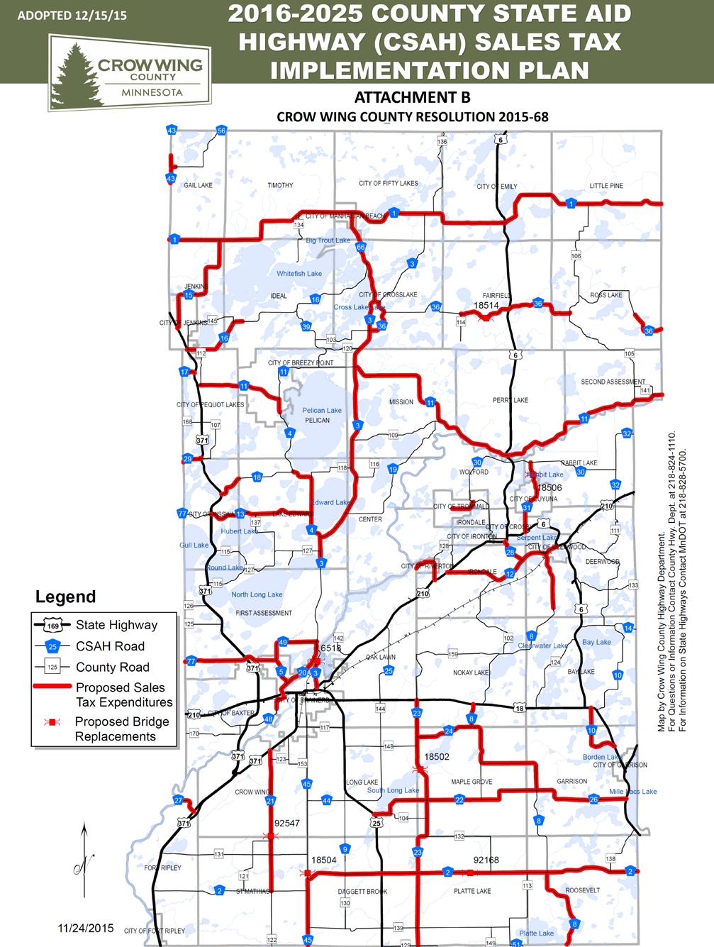
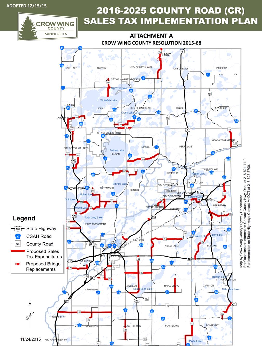
5 Primary Funding Sources Federal Funds Funds assigned to projects through federal transportation legislation, federally sponsored safety programs or other special federal programs. State Aid (SA) Funds (Regular) Annual allocation to the county from state gas tax and vehicle license or registration fees. Regular SA funds may be utilized for any element related to roadway construction or rehabilitation on the CSAH system. These funds may not be used on the CR system. State Aid (SA) Funds (Municipal) Annual allocation to the county from state gas tax and vehicle license or registration fees. Municipal SA funds are designated to be utilized for any element related to roadway construction or rehabilitation on the CSAH system located within the established boundaries of a municipality. These funds may not be used on the CR system or in areas outside of a municipality. County Road and Bridge Levy - Funds generated directly from Crow Wing County tax revenue. These levy funds are primarily intended to maintain the CR system but may also be used to supplement other funding sources. Local Option Sales Tax In late 2015 the Crow Wing County Board authorized the implementation of a ½ percent county-wide sales tax. State statue stipulates revenue generated from this tax is to be dedicated to fund specific transportation related projects. County Board resolution further stipulates the tax will end December 31, 2025 or when all of the identified projects are funded; whichever occurs first. Please refer to pages 40 and 41 for maps depicting projects authorized for sales tax expenditures. Adopted 4/10/ HIP 5
6 Primary Funding Sources First Assessment District (FAD) Road and Bridge Levy - Funds generated directly from township level tax revenue. These funds are designated to be utilized for any element related to roadway construction or rehabilitation within the FAD only. These funds are not intended to be used on the CR or CSAH system. Bridge Bonding Funding allocated by State legislative action to complete specific bridge construction projects on any County, Township or Municipal roadway within the County. Bridge bonding is normally only allocated after a complete set of bridge design plans has been developed. Adopted 4/10/ HIP 6
7 Highway Improvement Plan Summary $57.1M Total Investment (CWC/CR/FAD/SAD) $5.8M Federal Transportation Bill $22.6M County State Aid $6.1M CWC Road & Bridge Levy $1.7M First Assessment District Road & Bridge Levy $18.7M Local Sales Tax $712K State Bridge Funding $1.5M Local Cost Sharing 189 Miles of Road Improvements 113 Miles County State Aid Highway (1 & 2 Digit Roads) 64 Miles County Roads (3 Digit Roads) 12 Miles First Assessment District Roads 86 Miles Funded by Sales Tax 2 Bridge Replacements 3 Bridge Deck Improvements 7
8 All 5 Years Map 9 x 7 = 24% Adopted 4/10/ HIP 8


9 RQI Map 9 x 7 = 24% Adopted 4/10/ HIP 9
10 ADT Map 9 x 7 = 24% Adopted 4/10/ HIP 10
11 SUMMARY OF CHANGES SINCE LAST HIP PROPOSED 2018 PROGRAM 2018 RESURFACING CR Resurfacing from TH 371 to CSAH 16 Removed - Completed in 2017 CR Feasibility Study from Veteran's St. to CSAH 16 east Added to Perform Joint Project with City of Jenkins 2018 OTHER PROJECTS SPRA Garrison State Park Project Moved from Archaeological Issues to Address 2018 ENGINEERING CSAH CSAH 13/TH 371 Intersection Improvements Added as Part of 2021 Reconstruction Project PROPOSED 2019 PROGRAM 2019 RESURFACING CSAH Resurfacing from 7.7 mi. N. of TH 18 to CSAH 12 Moved up from 2020 CR Resurfacing at Entrance to County Landfill Added to take Advantage of MnDOT TH 210 Project 2019 SPOT IMPROVEMENTS CSAH CSAH 13/TH 371 Intersection Improvements Added as part of 2021 Reconstruction Project CSAH Storm Water Improvements at CSAH 66/Manhattan Pt. Blvd. Added as Joint Project with City of Crosslake - grant dependent 2019 OTHER PROJECTS CSAH Clearing and Grubbing for CSAH 13 East Reconstruction Project Added to meet Endangered Species Requirements CSAH Clearing and Grubbing for CSAH 36 Reconstruction Project Added to meet Endangered Species Requirements PROPOSED 2020 PROGRAM 2020 RESURFACING CR Resurfacing from CSAH 3 to Mission Lake Access Moved up from 2021 CR Resurfacing from CSAH 21 to CR 153 Moved up from 2021 CR Resurfacing from TH 371B to CSAH 45 Moved up from OTHER PROJECTS CSAH Clearing and Grubbing for CSAH 13 West Reconstruction Project Added to meet Endangered Species Requirements 2020 RIGHT OF WAY CSAH R/W Purchase for CSAH 23 Bridge Added to HIP PROPOSED 2021 PROGRAM 2021 RESURFACING CSAH Reconstruction from TH 371 to CR 137 Added to HIP CR Resurfacing from TH 371S to TH 371N Added to HIP CR Resurfacing from CSAH 3 to CSAH 19 Added to HIP CR Resurfacing from TH 210 to CSAH 59 Added to HIP 2021 RIGHT OF WAY CSAH CSAH 5/CSAH 49 R/W Purchase for 2022 Intersection Improvement Added to HIP Adopted 4/10/ HIP 11
12 2018 Map 9 x 7 = 24% Adopted 4/10/ HIP 12
13 2018 FUNDING COMMITMENTS FOR FUTURE PROJECTS CR CR 115 Project Planning & Construction CSAH Mill Avenue Bridge Rehabilitation 2018 RECONSTRUCTION 2018 RESURFACING None CSAH Resurfacing from CSAH 45 to TH 25 CSAH Resurfacing from Mill Ave. Bridge to Merrifield CSAH Resurfacing from County Line to TH 371 CSAH Resurfacing from Twin Leaf Circle to CSAH 4 CSAH Resurfacing from CSAH 2 to TH 371B CSAH Resurfacing from TH 210 to TH 6 CR Resurfacing from CSAH 10 to TH 210 CR Resurfacing from CSAH 4 to CSAH 3 CR Resurfacing from TH 18 to TH 6 CR Resurfacing from County Line to TH 371 CSAH Bridge #18512 Deck Resurfacing CR Bridge #18513 Deck Resurfacing 2018 SPOT IMPROVEMENTS Co. Wide Six Inch Wet Reflective, Grooved-in Pavement Markings CSAH CSAH 1/TH 6 Intersection Revision Emily 2018 OTHER PROJECTS Co. Wide Annual Pavement Marking Project Co. Wide Preventative Maintenance Surface Treatments TH Final Payback to Pequot Lakes for CSAH 11 Turnback CR CR 145 Feasibility Study - Veterans to CSAH 16 East 2018 ENGINEERING Co. Wide Various Engineering CR Consultant Project Development CSAH CSAH 13/TH 371 Intersection Improvements 2018 RIGHT OF WAY PROPOSED 2018 PROGRAM 2018 BRIDGE IMPROVEMENTS CSAH CSAH 3/CSAH 4 Intersection CSAH CSAH 13/CSAH 77/TH 371 Intersection Improvements Project Funded with Local Option Sales Tax Adopted 4/10/ HIP 13
14 2019 Map 9 x 7 = 24% Adopted 4/10/ HIP 14
15 2019 FUNDING COMMITMENTS FOR FUTURE PROJECTS CR CR 115 Project Planning & Construction CSAH Mill Avenue Bridge Rehabilitation 2019 RECONSTRUCTION 2019 RESURFACING None CSAH Resurfacing from 7.7 mi. N. TH 18 to CSAH 12 CSAH Resurfacing Loop south of TH 18 CSAH Resurfacing from TH 25 to CSAH 8 CSAH Resurfacing from CSAH 8 to TH 169 CR Resurfacing CSAH 1 to North Couthy Line CR Resurfacing CR 147 CR Resurfacing from TH 25 to CSAH BRIDGE IMPROVEMENTS None 2019 SPOT IMPROVEMENTS Co. Wide Unidentified HSIP Project CSAH CSAH 13/CSAH 77/TH 371 int. improvements CSAH CSAH 66 Storm Water Improvements - Manhattan Point Blvd OTHER PROJECTS Co. Wide Annual Pavement Marking Project CSAH Clearing and Grubbing for CSAH Clearing and Grubbing for Co. Wide Preventative Maintenance Surface Treatments 2019 ENGINEERING Co. Wide Various Engineering CR Consultant Project Development 2019 RIGHT OF WAY PROPOSED 2019 PROGRAM CSAH R/W Purchase for CSAH 13 Reconstruction CSAH R/W Purchase for CSAH 36 Reconstruction Project Funded with Local Option Sales Tax Adopted 4/10/ HIP 15
16 2020 Map 9 x 7 = 24% Adopted 4/10/ HIP 16
17 CR CR 115 Project Planning & Construction CSAH Mill Avenue Bridge Rehabilitation 2020 RECONSTRUCTION CSAH Reconstruction from CR 137 to CSAH 4 CSAH Reconstruction from CSAH 3 to CSAH RESURFACING CSAH Resurfacing from TH 6 to County line CSAH Resurfacing from CSAH 36 to CSAH 3 CSAH Schedule dependent upon Cass Co. schedule CSAH Schedule dependent upon Cass Co. schedule CR Resurfacing from CSAH 11 to McNeal Road CR Resurfacing from CSAH 3 to Mission Lake Access CR Resurfacing from CSAH 21 to CR 153 CR Resurfacing from TH 6 to Aitkin Co. Line CR Resurfacing from TH 371 to CSAH BRIDGE IMPROVEMENTS None 2020 SPOT IMPROVEMENTS Co. Wide Unidentified HSIP Project 2020 OTHER PROJECTS Co. Wide Annual Pavement Marking Project CSAH Clearing and Grubbing for Co. Wide Preventative Maintenance Surface Treatments 2020 ENGINEERING Co. Wide Various Engineering CSAH Project Development CR Consultant Project Development 2020 RIGHT OF WAY PROPOSED 2020 PROGRAM 2020 FUNDING COMMITMENTS FOR FUTURE PROJECTS CSAH R/W Purchase for CSAH 13 Reconstruction CSAH R/W Purchase for CSAH 23 Bridge Project Funded with Local Option Sales Tax Adopted 4/10/ HIP 17

18 2021 Map 9 x 7 = 24% Adopted 4/10/ HIP 18
19 2021 FUNDING COMMITMENTS FOR FUTURE PROJECTS CR CR 115 Project Planning & Construction CSAH Mill Avenue Bridge Rehabilitation 2021 RECONSTRUCTION CSAH Reconstruction from TH 371 to CR RESURFACING CSAH Resurfacing from TH 6 to East County line CSAH Resurfacing from TH 371 to CSAH 1 CSAH Resurfacing from TH 210 to Jackson Street CSAH Resurfacing from CSAH 23 to CSAH 8 CR Resurfacing from TH 371 S to TH 371 N CR Resurfacing from CSAH 3 to CSAH 19 CR Resurfacing from TH 210 to CSAH 59 - culvert at Blackhoof CSAH Replace Bridge #18502 over the Nokasippi River 2021 SPOT IMPROVEMENTS CR CR 125-TH 371 Reduced Conflict Intersection Co. Wide Six Inch Wet Reflective, Grooved-in Pavement Markings 2021 OTHER PROJECTS Co. Wide Annual Pavement Marking Project Co. Wide Preventative Maintenance Surface Treatments 2021 ENGINEERING Co. Wide Various Engineering CR Consultant Project Development 2021 RIGHT OF WAY PROPOSED 2021 PROGRAM 2021 BRIDGE IMPROVEMENTS CSAH CSAH 5/49 Intersection Project Funded with Local Option Sales Tax Adopted 4/10/ HIP 19
20 2022 Map 9 x 7 = 24% Adopted 4/10/ HIP 20
21 2022 FUNDING COMMITMENTS FOR FUTURE PROJECTS CR CR 115 Project Planning & Construction CSAH Mill Avenue Bridge Rehabilitation 2022 RECONSTRUCTION CSAH Intersection Improvement at CSAH RESURFACING CSAH Resurfacing from South County line to CSAH 22 CSAH Resurfacing from CSAH 22 to TH 18 CSAH Resurfacing from South County line to CSAH 2 north CR Resurfacing from CSAH 51 to CSAH 2 CR Resurfacing from TH 371B to CSAH 45 CR Resurfacing from TH 371 to CSAH 45 CR Resurfacing from CSAH 2 to TH 169 CSAH Replace Bridge #18504 over the Nokasippi River CSAH Bridge #18508 Deck Resurfacing 2022 SPOT IMPROVEMENTS 2022 OTHER PROJECTS None Co. Wide Annual Pavement Marking Project Co. Wide Preventative Maintenance Surface Treatments 2022 ENGINEERING Co. Wide Various Engineering CR Consultant Project Development 2022 RIGHT OF WAY PROPOSED 2022 PROGRAM 2022 BRIDGE IMPROVEMENTS None Project Funded with Local Option Sales Tax Adopted 4/10/ HIP 21

22 All 5 Years Graveling Road Map Adopted 4/10/ HIP 22
23 County Gravel Road Improvement Plan CR 139 CSAH 45 to CR 113 CR 105 McNeal Road to CSAH 36 CR 141 CR 105 to CSAH 11 CSAH 36 CR 105 to CR 106 CSAH 36 CR 106 to Cuyuna Trail PROPOSED 2018 GRAVELING PROPOSED 2019 GRAVELING PROPOSED 2020 GRAVELING PROPOSED 2021 GRAVELING CR 129 State Hwy 25 to CSAH 23 CR 132 CSAH 2 to CSAH 23 CR 142 County Hwy Department to French Rapids CR 149 CR 139 to South County Line PROPOSED 2022 GRAVELING CR 106 CSAH 36 to CSAH 1 CSAH Miles North CSAH 43 to North County Line 23

24 2023+ Map 9 x 7 = 24% 24
25 Notes 25

26 All 5 Years FAD Map 6.9 x 8.9 = 24% 26


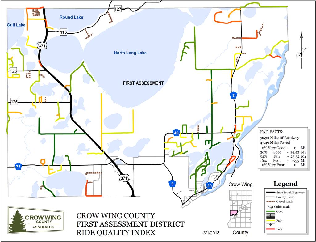
27 FAD RQI MAP 9 wide 27
28 2018 RESURFACING FAD Resurfacing Bonnie Road from CSAH 3 to 0.72 miles east FAD Resurfacing Donaldson Road FAD Resurfacing No. Long Lake Rd. from CSAH 3 to 1.25 miles west FAD Resurfacing St. Columbo Road FAD Resurfacing Stallman Rd. from Exec. Acres. Rd. to east end FAD Resurfacing East Shore Dr. from CSAH 3 to end 2018 OTHER PROJECTS FAD Wide Annual Pavement Marking Project 2018 ENGINEERING FAD Wide Various FAD Engineering 2019 RESURFACING FAD Resurfacing Gould Grey Rd. from Johnson Rd. to Bernard Rd. FAD Resurfacing Bernard Rd. from Gould Grey Rd. to N. end FAD Resurfacing Johnson Rd. from TH 371 to N. end 2019 OTHER PROJECTS FAD Wide Annual Pavement Marking Project 2019 ENGINEERING FAD Wide Various FAD Engineering 2020 RESURFACING FAD Resurfacing Soder Road FAD Resurfacing Round Lake Road 2020 OTHER PROJECTS FAD Wide Annual Pavement Marking Project 2020 ENGINEERING FAD PROPOSED 2018 PROGRAM FAD PROPOSED 2019 PROGRAM FAD PROPOSED 2020 PROGRAM FAD Wide Various FAD Engineering 28
29 2021 RESURFACING FAD Resurfacing Ahrens Hill Road from CSAH 20 to CSAH 20 FAD Resurfacing Miles Circle FAD Resurfacing Garrett Lane from Woida Road to N. end 2021 OTHER PROJECTS FAD Wide Annual Pavement Marking Project 2021 ENGINEERING FAD Wide Various FAD Engineering FAD PROPOSED 2022 PROGRAM 2022 RESURFACING FAD Resurfacing Landmark Drive from TH 371 to Birchdale Road FAD Resurfacing River Ridge Drive NW from Gull River Road to E. end FAD Resurfacing Hartley Drive from CR 125 to N. end FAD Resurfacing Heritage Road from CR 125 to N. end FAD Resurfacing Indigo Road from west end to TH OTHER PROJECTS FAD Wide Annual Pavement Marking Project FAD Seal Coat Barbeau Road from NW end to TH 371 FAD Seal Coat Bonnie Road from CSAH 3 to 0.72 miles east FAD Seal Coat Carlson Lake Road from CSAH 77 to Barbeau Road FAD Seal Coat Smith Road from CSAH 49 to Legionville Road 2022 ENGINEERING FAD PROPOSED 2021 PROGRAM FAD Wide Various FAD Engineering 29

30 All 5 Years SAD Map 30

31 All FAD gravel Map 31
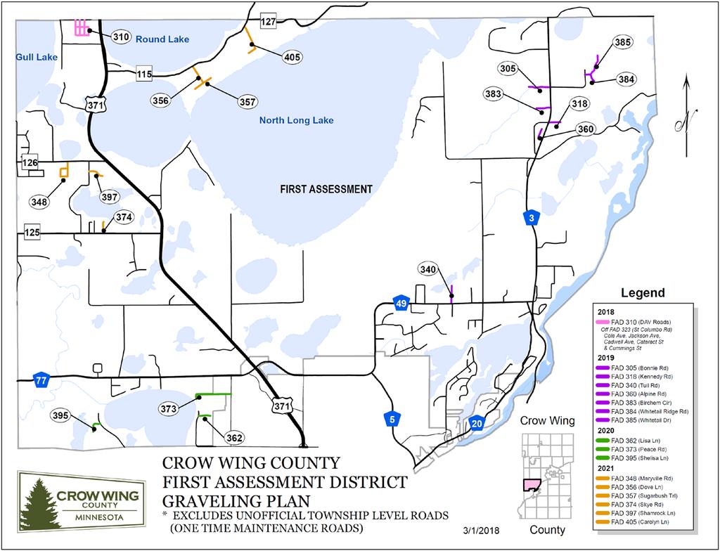
32 FAD Gravel Road Improvement Plan FAD 310 FAD 305 FAD 318 FAD 340 FAD 360 FAD 383 FAD 384 FAD 385 FAD 362 FAD 373 FAD 395 FAD 348 FAD 356 FAD 357 FAD 374 FAD 397 FAD 405 FAD 310 DAV Roads South of St. Columbo Bonnie Road From CSAH 3 to 0.3 Miles West Kennedy Road from CSAH 3 to 0.16 Miles East Tuil Road From CSAH 49 to 0.25 Miles North Alpine Road From CSAH 3 to Cul-De-Sac Birchem Circle from CSAH 3 to 0.17 Miles West Whitetail Ridge Road From Bonnie Road to 0.18 Miles East and South Whitetail Drive from Whitetail Ridge Road to 0.28 Miles North Lisa Lane From Garrett Lane to 0.16 Miles East Peace Road From Inglewood Drive to 0.55 Miles West Shelisa Lane From Welton Road to 0.18 Miles West and South Maryville Road From CR 126 to 0.49 Miles South Dove Lane From CR 115 to 0.28 Miles SE Sugar Bush Trail From Dove Lane to 0.16 Miles North and South Skye Road From CR 125 to 0.16 Miles North Shamrock Lane From Hartley Lake Road to 0.20 Miles East Carolyn Lane From CR 115 to 0.43 Miles South and West DAV Roads South of St. Columbo PROPOSED 2018 GRAVELING PROPOSED 2019 GRAVELING PROPOSED 2020 GRAVELING PROPOSED 2021 GRAVELING PROPOSED 2022 GRAVELING 32
33 Pavement Condition Ratings In Crow Wing County, a roadway s pavement condition is quantified using its Ride Quality Index (RQI) which is closely related to the overall roughness of that road section. Considerations are also given to the level of surface distress that it may be experiencing. Most commonly these take the form of roadway cracking and rutting and can be closely related to the roughness on some roadways. Generally RQI is used to determine when rehabilitation is needed. Understanding the type and cause of the surface distress helps determine what form of rehabilitation is needed. Crow Wing County uses the following RQI figures to classify each of its roadways: RIDE QUALITY INDEX (RQI) RANGES CATEGORY RQI VERY GOOD GOOD FAIR POOR VERY POOR 0-20 Note: Users commonly begin to complain when RQI drops below 50 The RQI and surface distress of each County State Aid Highway (CSAH) and County Road (CR) is measured by the Minnesota Department of Transportation (MnDOT) every two years. This serves as the basis of Crow Wing County s pavement management program. Using this data, well defined RQI deterioration curves (mathematical formulas) have been developed to project pavement condition between the years of these actual measurements. 33
34 Roadway Improvement Priority Roadway improvement priority is based on a combination of traffic volume expressed as Average Annual Daily Traffic (AADT) and Ride Quality Index (RQI). The following RQI thresholds are intended to assist decision makers determine when roadways in each category will be considered for resurfacing or other forms of rehabilitation. In general, higher volume roadways are expected to maintain higher standards of smoothness or RQI. Crow Wing County uses the following RQI threshold categories to assist setting roadway improvement priorities. In general, roadways with larger deviations from these established thresholds will receive higher priority while competing for limited funding resources. Roadways allowed to drop below these thresholds without being improved are defined as deferred. County State Aid Highway (CSAH) ADT RQI Goal Maintain Good/Very Good Rating for all High Volume CSAHs 2800< Maintain Fair/Good rating for all Moderate Volume CSAHs 500< Maintain Fair/Good rating for all Moderate Volume CSAHs < Maintain Fair Rating for all Low Volume CSAHs County Roads (CR) ADT RQI Goal Maintain Good/Very Good Rating for all High Volume CRs 2800< Maintain Fair/Good rating for all Moderate Volume CRs 500< Maintain Fair/Good rating for all Moderate Volume CRs < Maintain Fair Rating for all Low Volume CRs A comprehensive list of roadway priorities is included on pages 30 and 31. Please note that most roadways currently in a deferred status are scheduled for improvement over the next five years. Those listed with large RQI threshold deviations have been in deferred status for several years due primarily to limited transportation funding. 34
35 ROAD FROM TO LENGTH 2017 RQI 2018 County State Aid Highway (CSAH) Priority List Last Project Age CSAH 17 W CO LN PATRIOT AVE Poor CSAH Rural Major and Urban Collector 2018 CSAH 22 CSAH-23 CSAH Road 21 Poor 48 Priority CSAH Rural Major and Urban Collector 2019 CSAH 30 PENNINGTON ACCESS ROAD CSAH Poor CSAH Rural Major and Urban Collector 2018 CSAH 30 CSAH-34 TH Poor CSAH Rural Major and Urban Collector 2018 CSAH 43 ALONG W CO LN CSAH Poor CSAH Rural Minor Collector 2020 CSAH 56 CSAH MI N Poor CSAH Rural Minor Collector 2020 CSAH 11 TH-6 E CO LINE Poor CSAH Rural Major and Urban Collector 2020 CSAH 13 TH-371 CR Poor CSAH Rural Major and Urban Collector 2020 CSAH 13 CR-137 CSAH List Fair CSAH Rural Major and Urban Collector 2020 CSAH 22 TH-25 CSAH Fair CSAH Rural Major and Urban Collector 2019 CSAH 31 SOUTH ST NORTH ST CUYUNA Fair CSAH Rural Minor Collector CSAH MILES S OF CSAH-66 CSAH Fair CSAH Minor Arterial CSAH 10 S JCT TH-18 N JCT TH Fair CSAH Rural Major and Urban Collector 2019 Condition Rating RQI Threashold 2017 RQI DELTA Width 8.97 AADT Range Functional Class CSAH 36 CSAH-3 CSAH Fair CSAH Rural Major and Urban Collector 2020 CSAH 2 CSAH-45 TH Fair CSAH Rural Major and Urban Collector 2018 CSAH 30 TH-210 PENNINGTON ACCESS ROAD Fair CSAH Rural Major and Urban Collector 2018 CSAH 20 TH-210 JACKSON ST Fair CSAH Rural Major and Urban Collector 2021 CSAH 26 CSAH-8 TH Fair CSAH Rural Major and Urban Collector 2019 CSAH 36 CUYUNA TRAIL E CO LN Fair CSAH Rural Major and Urban Collector CSAH 3 TH-210 N LIMS BRAINERD Fair CSAH Minor Arterial CSAH MI N TH-18 CSAH Fair CSAH Rural Major and Urban Collector 2019 CSAH 21 CR-131 TH Fair CSAH Rural Minor Collector 2018 CSAH 37 CSAH-36 CSAH Fair CSAH Rural Minor Collector 2020 CSAH 3 N LIMS BRAINERD CRYSTAL LAKE ROAD Good CSAH Minor Arterial 2018 PROGRAM YEAR 35

36 ROAD FROM TO LENGTH 2017 RQI 2018 County Road (CR) Priority List Last Project Age CR 124 TH-18 TH Poor CR Local 2018 CR 115 S JCT TH-371 CR Poor CR Rural Minor Collector CR 115 CR 127 N JCT TH Poor CR Rural Minor Collector CR 148 TH-25 CSAH-23 CR Priority Poor List CR Local 2019 CR 111 CSAH-10 TH Poor CR Local 2018 CR 136 CSAH-1 N CO LN Poor CR Rural Minor Collector 2019 CR 107 S JCT TH-371 N JCT TH Fair CR Local 2021 CR 117 TH-371 CSAH Fair CR Rural Major and Urban Collector 2022 CR 105 CSAH-11 MCNEAL ROAD Poor CR Rural Minor Collector 2020 Condition Rating RQI Threashold 2017 RQI DELTA AADT Range Functional Class CR 116 CSAH-3 MISSION LAKE ACCESS Fair CR Local 2020 CR 147 TH-210 CO LANDFILL Fair CR Local 2019 CR 133 S JCT TH-6 E CO LN Fair CR Local 2020 CR 138 CSAH-2 TH Fair CR Local 2022 CR 113 CSAH-51 CSAH Fair CR Rural Minor Collector 2022 CR 123 CSAH-21 CR Fair CR Local 2020 CR 118 CSAH-4 CSAH Fair CR Local 2018 CR 145 POUALACK ST (JENKINS) VETERANS ST (JENKINS) Fair CR Rural Minor Collector CR 145 VETERANS ST (JENKINS) CSAH Fair CR Rural Minor Collector CR 168 W CO LN PATRIOT AVE Fair CR Local 2018 CR 109 CSAH-3 CSAH Fair CR Rural Minor Collector 2021 CR 131 KOERING RD CSAH-45 (SLEEPY HOLLOW RD) Fair CR Rural Minor Collector 2022 CR 128 TH-210 CSAH Fair CR Local 2021 PROGRAM YEAR 36
37 Roadway Improvement Deferments In 2015 Crow Wing County started to place an increased focus on eliminating the occurrences of roadway improvement deferments. The goal is to have zero deferments by The implementation of the county-wide sales tax was specifically intended to generate the transportation funding necessary to make roadway improvements as soon as the RQI threshold is reached. Please refer to page 39 for a graphical depiction of how the roadway improvements contained in this document are advancing Crow Wing County s goal of eliminating deferments by
38 Deferment Elimination Progress 38
39 39
40 40

41 Sales Tax Utilization Map 41
42 FC Map 9 x 7 = 24% 42
43 Bridge Priority Map 43
44 Bridge Number L Location CSAH 23 (Noka. River) CSAH 45 (Noka. River) CSAH 31 (Rabbit Lake) CSAH 36 (Mud Brook) CSAH 3 (Mississippi River) CSAH 2 (Daggett Brook) CSAH 21 (Hay Creek) CSAH 66 (Daggett Brook N.) CR 136 (Crooked Creek) CSAH 15 (Pine River) 2018 CSAH/CR/FAD Bridge Replacement Priority List Road System Replacement Year Built ADT Suff. Rating Cost Funding Remarks CSAH (2008) 71.2 $349,500 State Bonding/State Aid Deteriorating condition of the superstructure and substructure. Longitudinal cracks in lower legs of the channels. The piles have moderate decay occurring w/ isolated section loss. In initial planning and design w/ replacement anticipated in CSAH (2008) 70.4 $807,100 State Bonding/State Aide Considered structurally deficient because of the deteriorated condition of the center channels in the center and north spans. The rest of the superstructure continues to Deteriorate with longitudinal cracks in lower legs of the channels. In initial planning w/ replacement anticipated in CSAH ,663 (2008) 62.4 $781,500 State Bonding/State Aid Deteriorating condition of the superstructure. Rusting occurring in the steel bridge beams. Deterioration of the outside beams is too far advanced for painting to be practical. Need to plan for a replacement in the next 5 to 10 years. LEAD PAINT! CSAH (2008) 64.5 $270,800 State Bonding/State Aid General Deterioration. Too narrow for current traffic level. Currently in the preliminary design phase. CSAH ,300 (2015) 66.6 $3,330,100 State Bonding/State Aide Minor deterioration of the deck and steel beams in non-critical locations. The piers have moderate to heavy concrete scaling typically from 6 inches above to 3 feet below the waterline w/ penetrations up to 2 inches exposing the reinforcing steel. Bridge is restricted to some over weight vehicles. Anticipate a $ 250K to $300K rehab and paint project in 5 to 10 years. CSAH ,663 (2008) 82.5 $255,000 CSAH ,361 (2008) 94.2 $275,600 CSAH (2008) 94.7 $1,732,200 State Bonding/State Aid State Bonding/State Aide State Bonding/State Aide Galvanized steel plate culvert. Rusting and pitting at and below the waterline. Galvanized steel plate culvert. Rusting and pitting at and below the waterline. Concrete wearing surface and fascia repair. There are cracks in the concrete surface along the bridge "T" beam joints. There is delamination on the outside faces of the bridge that if left unchecked could be a danger to passing boaters. Anticipate a $250K deck rehab project in 5 to 10 years. Cnty (2015) 94.8 $270,800 CSAH (2015) 90.6 $970,400 State Bonding/ Local Levy State Bonding/State Aide General Deterioration. Initial section loss of the wood piling. Approach fill is eroding away behind the backer boards & wingwalls, causing sinkholes to develop in the approaches. Planning for a new bituminous wearing surface in 2019 in conjunction with planned road work. Good candidate for a bridge rehab. Anticipate a $300K to $350K for a deck rehab and painting the bridge beams. LEAD PAINT! The bridge is scheduled for approach work w/ the bituminous road paving in Bridges highlighted in yellow are contained in the proposed 2017 Crow Wing County bridge priority resolution. Replacement costs are based on construction costs from 2015, 2016 and
45 Bridge Number L2849 L3942 L5862 Location Oak Lawn (Jordan Rd.) St. Mathias (Koering Rd.) Maple Grove (Leisure Lane) 2018 Township Bridge Replacement Priority List Road System Replacement Year Built ADT Suff. Rating Cost Funding Remarks TWP (1991) 59.9 $150,000 Town Bridge Deteriorated conditions. Posted at 26/40 tons. Dead end road, old TH 210 segment, providing access to limited residential properties. TWP (1973) 19.9 $457,100 Town Bridge STRUCTURALLY DEFICIENT. CLOSED. Out of service since Through "town line" road. TWP (1989) 81.0 $223,600 Town Bridge Posted at 26/40 tons, Through road surving properties along the south shore of Upper South Long Lake. Initial deterioration of the wood piles and the fasteners in wood slab superstucture. Bridges highlighted in yellow are contained in the proposed 2017 Crow Wing County bridge priority resolution. 45
46 Bridge Number 2616 L2877 L (L6376) 2018 City Bridge Replacement Priority List Location Road System Year Built ADT Suff. Rating Replacement Cost Funding Remarks Nisswa (Hazelwood Dr.) City (2008) 37.3 $174,800 State Bonding FUNCTIONALLY OBSOLETE. Posted at 18/30 tons. Through road serving residential and recreational developments. Roosevelt Dr. (Crooked Creek) City (1986) 64.9 $406,540 State Bonding Deteriorating condition of the superstructure. Rusting occurring in the steel bridge beams. Dam Rd. (Emily) City (1986) 50.2 $304,500 Local Posted at 18/30 tons. Dead end road providing access to state and public lands. Only timber harvesters impacted by the load rating at this time. There are no permanent residents on the far side of the bridge. As the wood decking and steel beams deteriorate expect the load rating to continue to fall. Minimum deck rehab recommended only. Crosslake (Dream Island Rd.) City 2017 < $454,500 w/ approach work State Bonding Bridge was completed late last fall, The approaches still need to be paved and seeded. Bridges highlighted in yellow are contained in the proposed 2017 Crow Wing County bridge priority resolution. Bridges highlighted in red are under construction. 46
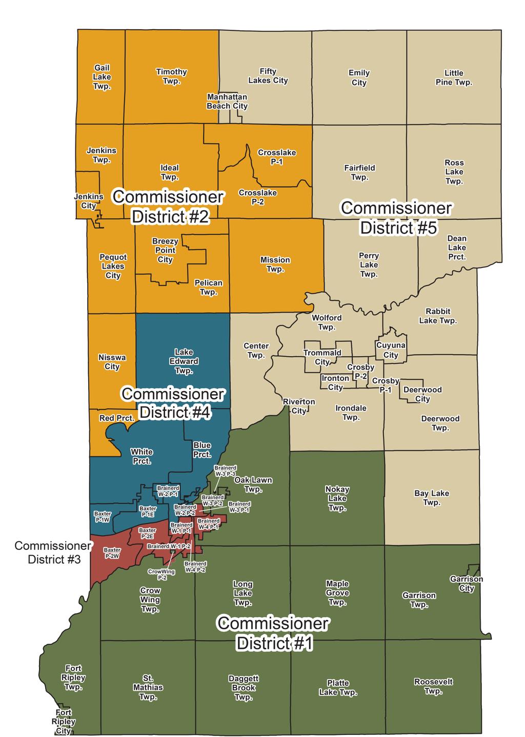
47 Contact Information Crow Wing County Highway Department County Road 142 Brainerd, MN Timothy Bray, P.E. County Engineer Rob Hall, P.E. Assistant County Engineer Crow Wing County Commissioners 326 Laurel Street Brainerd, MN Paul Koering District 1 Paul Thiede District 2 Rachel Reabe-Nystrom District 3 Rosemary Franzen District 4 Doug Houge District 5 47
48 48
49 Notes 49
Recommended Transportation. Capital Improvement Program
 Recommended 2018-2022 Transportation Capital Improvement Program 1 Overview 2017 Review 2018-2022 Considerations 2018-2022 Recommended CIP 2 Limited Resources are Directed to the Highest Priority Number
Open House. Highway212. Meetings. Corridor Access Management, Safety & Phasing Plan. 5:30 to 6:30 p.m. - Southwest Corridor Transportation Coalition
 Welcome Meetings 5:30 to 6:30 p.m. - Southwest Corridor Transportation Coalition 6:30 to 8:00 p.m. - Open House Why is Highway 212 Project Important? Important Arterial Route Local Support Highway 212
Transportation Improvement Program (TIP) Candidate Project List for Public Review
 Candidate Project List for Public Review") 2011-2014 Transportation Improvement Program (TIP) Candidate List for Public Review Table 1 Annual Listing Of Federal Aid Obligation For Federal Fiscal Year 2010 North Dakota s Number Transit 410083 Transit
2011-2014 Transportation Improvement Program (TIP) Candidate List for Public Review Table 1 Annual Listing Of Federal Aid Obligation For Federal Fiscal Year 2010 North Dakota s Number Transit 410083 Transit
Kentucky Highway District 6
 Kentucky Highway District 6 ROAD AND BRIDGE CONDITIONS, TRAFFIC SAFETY, TRAVEL TRENDS, AND NEEDS MARCH 2018 PREPARED BY WWW.TRIPNET.ORG Founded in 1971, TRIP of Washington, DC, is a nonprofit organization
Subarea Study. Manning Avenue (CSAH 15) Corridor Management and Safety Improvement Project. Final Version 1. Washington County.
 Corridor Management and Safety Improvement Project. Final Version 1. Washington County.") Subarea Study Manning Avenue (CSAH 15) Corridor Management and Safety Improvement Project Final Version 1 Washington County June 12, 214 SRF No. 138141 Table of Contents Introduction... 1 Forecast Methodology
Subarea Study Manning Avenue (CSAH 15) Corridor Management and Safety Improvement Project Final Version 1 Washington County June 12, 214 SRF No. 138141 Table of Contents Introduction... 1 Forecast Methodology
Public Information Packet FY Fargo-Moorhead Metropolitan Transportation Improvement Program (TIP)
") Public Information Packet FY - Fargo-Moorhead Metropolitan Transportation Improvement Program (TIP) Comment Form Annual Element TIP Projects - TIP Projects Year - Metropolitan Transportation Improvement
Public Information Packet FY - Fargo-Moorhead Metropolitan Transportation Improvement Program (TIP) Comment Form Annual Element TIP Projects - TIP Projects Year - Metropolitan Transportation Improvement
FREQUENTLY ASKED QUESTIONS
 THE PROJECT Last updated on 2/19/16 FREQUENTLY ASKED QUESTIONS What s happening on Highway 169? The Minnesota Department of Transportation (MnDOT) is planning to rebuild and repair the infrastructure on
CAPITAL FUND 9510 STREET & SIDEWALK IMPROVEMENTS FIVE-YEAR CAPITAL IMPROVEMENT PROGRAM FISCAL YEARS
 9510 STREET & SIDEWALK IMPROVEMENTS FIVE-YEAR CAPITAL IMPROVEMENT PROGRAM FISCAL YEARS 2019-2023 9510 STREET & SIDEWALK IMPROVEMENTS - 01 STREET AND SIDEWALK MAINTENANCE PROGRAM $1,250,000 $0 $1,250,000
FREQUENTLY ASKED QUESTIONS
 THE PROJECT Last updated on 9/8/16 FREQUENTLY ASKED QUESTIONS What s happening on Highway 169? The Minnesota Department of Transportation (MnDOT) is planning to rebuild and repair the infrastructure on
CROW WING COUNTY HIGHWAY DEPARTMENT APPLICATION FOR PERMIT TO CONSTRUCT DRIVEWAY ACCESS TO ROADS UNDER COUNTY JURISDICTION CONSTRUCTION INFORMATION
 CROW WING COUNTY HIGHWAY DEPARTMENT APPLICATION FOR PERMIT TO CONSTRUCT DRIVEWAY ACCESS TO ROADS UNDER COUNTY JURISDICTION Crow Wing County Highway Department 16589 CR 142 Brainerd, MN 56401 Crow Wing
US 10 Corridor Performance
 Corridor Context The corridor runs northwest 18 miles from I-35W to the edge of Anoka County. The corridor connects the cities of Ramsey, Anoka,, Mounds View, and Blaine. Current Corridor Characteristics
Population Trends. US 12 Corridor Performance
 Corridor Context The corridor runs over 81 miles from Willmar to the Twins Cities metropolitan area. It connects the Twin Cities and the cities of Montrose, Howard Lake, Cokato, Dassel, Litchfield, Atwater,
EXCEPTION TO STANDARDS REPORT
 EXCEPTION TO STANDARDS REPORT PROJECT DESCRIPTION AND NEED The project is located in Section 6, Township 23 North, Range 9 East and Section 31 Township 24 North, Range 9 East, in the Town of Stockton,
Tulsa Transportation Management Area. Urbanized Area Surface Transportation Program
 Tulsa Transportation Management Area Urbanized Area Surface Transportation Program FFY 2022 Application Information Sponsor Location Description STP Request Other Funds Broken Arrow Elm Place: Kenosha
Kentucky Highway District 1
 Kentucky Highway District 1 ROAD AND BRIDGE CONDITIONS, TRAFFIC SAFETY, TRAVEL TRENDS, AND NEEDS FEBRUARY 2018 PREPARED BY WWW.TRIPNET.ORG Founded in 1971, TRIP of Washington, DC, is a nonprofit organization
Welcome. Highway 23 Gap New London to Paynesville. Open House. - Please Sign In -
 Highway Gap New London to Paynesville Welcome Highway Gap New London to Paynesville Open House - Please Sign In - There is no formal presentation, but representatives are available to answer your questions.
Northeast Pavement Preservation Partnership Burlington, Vermont. Rhode Island DOT
 Northeast Pavement Preservation Partnership Burlington, Vermont Rhode Island DOT April 8, 2014 SHRP2 R26 (Preservation of High-Traffic Volume Roadways) and MAP-21 Impacts to RIDOT Pavement Management David
Engineering Report: Shasta-Trinity National Forest. South Fork Management Unit. Analysis of. National Forest System Road 30N44
 Engineering Report: Shasta-Trinity National Forest South Fork Management Unit Analysis of National Forest System Road 30N44 (milepost 0.00 to 0.40) for Motorized Mixed Use Designation Forest: Shasta-Trinity
Brigham City 1200 West Box Elder Creek Bridge - Widening Project Type Reconstruction
 Brigham City 1200 West Box Elder Creek Bridge - Widening Project Type Reconstruction 550 North to 650 North $ 1,750,000 $ 1,582,113 To widen an existing bridge on 1200 West over Box Elder Creek that will
Plainfield, Indiana Speed Limit Study
 March 21 st, 2017 Prepared on behalf of: Town of Plainfield Building and Engineering Department 206 W. Main Street Plainfield, IN 46168 (317) 839-2561 Prepared by: Thomas S. Vandenberg, PE, PTOE Matthew
RE: S.P (T.H. 210) in Crow Wing County Located on T.H. 210 from Brainerd (R.P ) to Ironton (R.P )
 in Crow Wing County Located on T.H. 210 from Brainerd (R.P ) to Ironton (R.P )") District 3 Administration 7964 Industrial Park Road Baxter, MN 56425 Memo To: Dan Anderson Transportation District Engineer From: Scott Zeidler Senior Engineering Specialist Date: December 11, 2017 RE:
District 3 Administration 7964 Industrial Park Road Baxter, MN 56425 Memo To: Dan Anderson Transportation District Engineer From: Scott Zeidler Senior Engineering Specialist Date: December 11, 2017 RE:
Crow Wing. County - Minnesota Resource & Relocation Guide
 Crow Wing County - Minnesota 2018-2019 Resource & Relocation Guide 1 2 3 CONTENTS 7 Welcome Published By: In association with 8-9 Newcomer Information 10 Help Hotlines 11 Health & Hospitals 13 Local Education
Transportation. Background. Transportation Planning Goals. Level of Service Analysis 5-1
 Transportation portion of the city s stormwater utility, and state road and fuel taxes. Background The transportation needs of the City of Lacey and its planning areas are met by a growing multimodal network
Transportation accomplishments
 1 1 Welcome Transportation accomplishments Federal Funding State Funding Challenges Future Projects 2 Transportation Project: The NDDOT had a record construction season in 2011. Completed $595.6 million
TABLE OF CONTENTS EXECUTIVE SUMMARY...1 INTRODUCTION...3 PROJECTED FUTURE GROWTH...3 ROADWAY IMPROVEMENT PROJECTS...4 POTENTIAL FUNDING SOURCES...
 Transportation Impact Fee Study September 2014 TABLE OF CONTENTS EXECUTIVE SUMMARY...1 INTRODUCTION...3 PROJECTED FUTURE GROWTH...3 ROADWAY IMPROVEMENT PROJECTS......4 POTENTIAL FUNDING SOURCES...7 PROPOSED
The State of SCDOT. Presented: February 1, 2017 Secretary Christy A. Hall, P.E.
 The State of SCDOT Presented: February 1, 2017 Secretary Christy A. Hall, P.E. As we enter our Centennial Year, we have much to do together. 2 Looking # Back # over # the # past # 12 # months Y Y Y Y Y
Workshop Agenda. I. Introductions II. III. IV. Load Rating Basics General Equations Load Rating Procedure V. Incorporating Member Distress VI.
 Workshop Agenda I. Introductions II. III. IV. Load Rating Basics General Equations Load Rating Procedure V. Incorporating Member Distress VI. Posting, SHV s and Permitting VII. Load Rating Example #1 Simple
Corridor Sketch Summary
 Corridor Sketch Summary SR 241: I-82 Jct (Sunnyside) to SR 24 Jct Corridor Highway No. 241 Mileposts: 7.53 to 25.21 Length: 17.65 miles Corridor Description The seventeen and one-half mile corridor begins
Purpose and Need Report
 Purpose and Need Report State Highway (SH) 29 From Southwestern Boulevard to SH 95 Williamson County, Texas (CSJ: 0337-02-045) Prepared by Blanton & Associates, Inc. Date: November, 2015 The environmental
Engineering Report: Shasta-Trinity National Forest. Shasta McCloud Management Unit. Analysis of. National Forest System Road 37N79
 Engineering Report: Shasta-Trinity National Forest Shasta McCloud Management Unit Analysis of National Forest System Road 37N79 (milepost 0.56 to 2.28) for Motorized Mixed Use Designation Forest: Shasta-Trinity
Highway 23 New London Access & Safety Assessment. Public Open House #2 October 3, :00 to 7:00 PM
 Public Open House #2 October 3, 2017 5:00 to 7:00 PM Highway 9 OVERVIEW OF ASSESSMENT Assessment Limits Highway 23 from County Road 40 to North Shore Dr Purpose: Identify opportunities to reduce serious
Lake County Building Department
 Lake County Building Department P.O. Box 513 505 Harrison Avenue Leadville, CO 80461 (719) 486-2875 Fax (719) 486-4179 Driveway Permit (Resolutions 98-15 and 98-35) PERMIT: To connect a driveway or parking
Pavement Management Plan
 2015 Pavement Management Plan Baker City Public Works Department 1655 1st Street P.O. Box 650 Baker City, OR 97814 Phone: (541) 523-6541 Fax: (541) 524-2029 www.bakercity.com/departments/public-works-dept
Harris Township 2017 Road inspections
 1 P a g e Harris Township 2017 Road inspections The 2017 Road Inspections were done on May 9 and May 11. The entire board rode together and discussed the roads. This report is a summary of the road inspection
INTERSECTION CONTROL EVALUATION
 INTERSECTION CONTROL EVALUATION Trunk Highway 22 and CSAH 21 (E Hill Street/Shanaska Creek Road) Kasota, Le Sueur County, Minnesota November 2018 Trunk Highway 22 and Le Sueur CSAH 21 (E Hill Street/Shanaska
CEDAR AVENUE TRANSITWAY Implementation Plan Update
 CEDAR AVENUE TRANSITWAY Implementation Plan Update EECUTIVE SUMMARY DECEMBER 2015 Executive Summary In 2013, the Twin Cities metropolitan area s first bus rapid transit (BRT) line, the METRO Red Line,
Southern Windsor County 2016 Traffic Count Program Summary April 2017
 Southern Windsor County 2016 Traffic Count Program Summary April 2017 The Southern Windsor County Regional Planning Commission (the RPC ) has been monitoring traffic at 19 locations throughout the southern
TRAFFIC CALMING PROGRAM
 TRAFFIC CALMING PROGRAM PROGRAM BASICS Mount Pleasant Transportation Department 100 Ann Edwards Lane Mt. Pleasant, SC 29465 Tel: 843-856-3080 www.tompsc.com The Town of Mount Pleasant has adopted a traffic
HURON COUNTY ENGINEER S OFFICE
 HURON COUNTY ENGINEER S OFFICE 2017 ENGINEER S ANNUAL REPORT The Ohio Revised Code requires that each Ohio County Engineer publish an annual report to the commissioners outlining the general condition
TRAFFIC IMPACT STUDY. USD #497 Warehouse and Bus Site
 TRAFFIC IMPACT STUDY for USD #497 Warehouse and Bus Site Prepared by: Jason Hoskinson, PE, PTOE BG Project No. 16-12L July 8, 216 145 Wakarusa Drive Lawrence, Kansas 6649 T: 785.749.4474 F: 785.749.734
CSG National Conference Nashville
 CSG National Conference Nashville South Dakota Needs and Funding Challenges and Successes December 11, 2015 Road to Success Bipartisan Roads and Funding Task Force Alliance of interest groups Roads are
Appendix G Aquilla Lake Pool Rise Recreational Resources
 Appendix G Aquilla Lake Pool Rise Recreational Resources 1. INTRODUCTION The purpose of this appendix is to document the impacts of a 2.5 ft (Alternative A), 4.5 ft (Alternative B), and 6.5 ft. (Alternative
Street Lighting Policy. Revision
 Street Lighting Policy Revision 5-2017 Grand Chute Street Lighting Policy - 1 - May 2, 2017 Intent: The intent of this policy is to outline the Town of Grand Chute s standards for the installation and
Revised Evaluation Scores. System Preservation
 Revised Evaluation s System Preservation This page provides a summary of any revisions made to the draft scores presented at the October th Attributable Funds mmittee meeting. The information below highlights
2016 Congestion Report
 2016 Congestion Report Metropolitan Freeway System May 2017 2016 Congestion Report 1 Table of Contents Purpose and Need...3 Introduction...3 Methodology...4 2016 Results...5 Explanation of Percentage Miles
Alpine Highway to North County Boulevard Connector Study
 Alpine Highway to North County Boulevard Connector Study prepared by Avenue Consultants March 16, 2017 North County Boulevard Connector Study March 16, 2017 Table of Contents 1 Summary of Findings... 1
Public Information Workshop
 Public Information Workshop Charlotte County-Punta Gorda MPO - Meeting Rooms A and B March 29, 2018 Welcome to the Public Information Workshop for Harborview Road Project Development and Environment (PD&E)
# of Projects STIP Total Other FHWA Target FHWA Total FHWA Target AC Total AC
 DISTRICT/ATP 6 Data Input Worksheet STIP 2014 2017 Needed for 10 yr workplan Needed for 10 yr workplan YEAR # of Projects STIP Total Other FHWA Target FHWA Total FHWA FTA State TH DIST C TH Total TH Bond
I-394 Corridor Performance
 Population Trends Corridor Context The corridor runs from edge of Hennepin County to downtown Minneapolis and serves the cities of Delano, Independence, Medina, and Wayzata. City Population 2000 2010 2,088
F:\PROJ\ \dwg\Alt-bridge-alignments.dwg, 17-2, 11/12/ :22:17 PM, saamhu, Acrobat PDFWriter
 F:\PROJ\55211014\dwg\Alt-bridge-alignments.dwg, 17-2, 11/12/2002 03:22:17 PM, saamhu, Acrobat PDFWriter MERRIFIELD RIVER CROSSING METHOD OF CHANGE FROM ID# ISSUES MEASUREMENT UNITS VALUE BASE CONDITIONS
2018 Proposed Budget. Table of Contents. Appropriation Act. 1. Budget by Fund. 2. Michigan Transportation Funds.. 3. Work Performed for Others...
 2018 Proposed Budget Table of Contents Appropriation Act. 1 Budget by Fund. 2 Michigan Transportation Funds.. 3 Work Performed for Others.... 4 Construction and Preservation... 5 Primary Construction......
Current Corridor Characteristics. MN 62 Corridor Performance
 Corridor Context The corridor runs 12 miles between I-494 and MN 55 south of Minneapolis. The corridor serves as an important East-West connection for the Metro area. A portion of the corridor has been
Delaware County Engineer s Office
 Delaware County Engineer s Office JANUARY 2017 County Engineer Responsibility Serve as engineer to the Board of County Commissioners and 18 Boards of Township Trustees for roads, bridges and land surveying
Project Application. General Information ODOT PID. Primary County (3 char abrv) ODOT District
 ODOT District") Current Status (Tier 1, Tier 2 or New) Proposed Status (Tier 1 or Tier 2) Project Application General Information ODOT PID ODOT District Primary County (3 char abrv) Facility Name (i.e. route, rail, terminal,
Current Status (Tier 1, Tier 2 or New) Proposed Status (Tier 1 or Tier 2) Project Application General Information ODOT PID ODOT District Primary County (3 char abrv) Facility Name (i.e. route, rail, terminal,
Public Works. Capital Projects FY
 Public Works Capital Projects FY 2015-17 Projects Completed FY 2014 All Done Projects! Residential and Collector Street Paving Lower Westside Arterial Street Rehab: Front, River St South, Soquel Hwy 1
Right-of-Way Obstruction Permit Fee Structure Minneapolis Department of Public Works May 10, 2001
 Right-of-Way Obstruction Permit Fee Structure Minneapolis Department of Public Works May 10, 2001 Revised April 5, 2005 Revised January 27, 2006 Prepared by: Steve Collin, Engineer 2.5 Revised by Douglas
CITY OF TORRANCE PUBLIC WORKS DEPARTMENT ENGINEERING DIVISION INFRASTRUCTURE UPDATE
 CITY OF TORRANCE PUBLIC WORKS DEPARTMENT ENGINEERING DIVISION INFRASTRUCTURE UPDATE TUESDAY, DECEMBER 5, 2017 1 DISCUSSION TOPICS Update of Infrastructure Action Plan (IAP) o Sidewalk and Roadway projects
Funding Scenario Descriptions & Performance
 Funding Scenario Descriptions & Performance These scenarios were developed based on direction set by the Task Force at previous meetings. They represent approaches for funding to further Task Force discussion
The major roadways in the study area are State Route 166 and State Route 33, which are shown on Figure 1-1 and described below:
 3.5 TRAFFIC AND CIRCULATION 3.5.1 Existing Conditions 3.5.1.1 Street Network DRAFT ENVIRONMENTAL IMPACT REPORT The major roadways in the study area are State Route 166 and State Route 33, which are shown
Performance-Based Communication Tools for Maintenance Budgets. 11th National Conference on Transportation Asset Management July 12th, 2016.
 Performance-Based Communication Tools for Maintenance Budgets 11th National Conference on Transportation Asset Management July 12th, 2016 Rob Zilay Presentation Outline Performance-based maintenance tools
Introduction. Assumptions. Jeff Holstein, P.E., City of Brooklyn Park Steve Wilson, Principal Tim Babich, Associate Krista Anderson, Engineer
 SRF No. 10482 To: From: Jeff Holstein, P.E., City of Brooklyn Park Steve Wilson, Principal Tim Babich, Associate Krista Anderson, Engineer Date: May 16, 2018 Subject: City of Brooklyn Park Year 2040 Forecasts
Highway 18 BNSF Railroad Overpass Feasibility Study Craighead County. Executive Summary
 Highway 18 BNSF Railroad Overpass Feasibility Study Craighead County Executive Summary October 2014 Highway 18 BNSF Railroad Overpass Feasibility Study Craighead County Executive Summary October 2014 Prepared
Metropolitan Freeway System 2013 Congestion Report
 Metropolitan Freeway System 2013 Congestion Report Metro District Office of Operations and Maintenance Regional Transportation Management Center May 2014 Table of Contents PURPOSE AND NEED... 1 INTRODUCTION...
January 13, 2012 AACE Annual Meeting, Wickenburg, AZ. I-15 in Arizona. Its Past, Present, and Future
 January 13, 2012 AACE Annual Meeting, Wickenburg, AZ I-15 in Arizona. Its Past, Present, and Future Jean A. Nehme, Ph.D., P.E. State Bridge Engineer, ADOT Presentation Overview Location, History, and Photographs
2040 Metropolitan Transportation Plan -- Table XVII-1
 C:\7. \Projects\ 2040MTP Project List_Nov16-16.xlsx ID # NAME LIMITS DESCRIPTION COST () AGENCY PROJECT TYPE* 2017 1 B Dr S and Capital Ave SW B Dr S from 3.5 Mile Rd eastward to M-66 (1.7 mi); Capital
City of Grand Forks Staff Report
 City of Grand Forks Staff Report Service/Safety Committee December 15, 2015 City Council December 21, 2015 Agenda Item: Amendment No. 1 to Engineering Services Agreement with CPS for City Project No. 7143,
Rural Planning. Highway Projects - CULLMAN COUNTY
 4/17/2015 ALABAMA DEPARTMENT OF TRANSPORTATION Page - 1 of 9 Length CR-1742 4.770 Highway s - CULLMAN COUNTY RESURFACE CR-1742 FROM SR-74 (US-278) TO SR-67 RESURFACING 100063223 ST-022-888-011- ( ) CONSTRUCTION
SECONDARY ROAD CONSTRUCTION PROGRAM
 Iowa Department of Transportation SECONDARY ROAD CONSTRUCTION PROGRAM County: Linn County Fiscal : 2014 Version: Original COUNTY CERTIFICATION The detailed construction program for the secondary road system
RSMS. RSMS is. Road Surface Management System. Road Surface Management Goals - CNHRPC. Road Surface Management Goals - Municipal
 RSMS Road Surface Management System RSMS is. CNHRPC Transportation Advisory Committee 6/1/12 1 2 a methodology intended to provide an overview and estimate of a road system's condition and the approximate
CHAPTER 9: VEHICULAR ACCESS CONTROL Introduction and Goals Administration Standards
 9.00 Introduction and Goals 9.01 Administration 9.02 Standards 9.1 9.00 INTRODUCTION AND GOALS City streets serve two purposes that are often in conflict moving traffic and accessing property. The higher
City of University Place
 City of University Place City Engineering Department Six Year Transportation Improvement Plan Amended November 10, 2008 Resolution No. 604 City of University Place, Washington SIX-YEAR TRANSPORTATION PLAN
East Kings Highway and Roberts Avenue Speed Hump Analysis
 East Kings Highway and Roberts Avenue Speed Hump Analysis BOROUGH OF HADDONFIELD, CAMDEN COUNTY, NEW JERSEY 5/18/2018 Prepared By: Remington & Vernick Engineers 232 EAST KINGS HIGHWAY, HADDONFIELD, NEW
BINGHAMTON METROPOLITAN TRANSPORTATION STUDY
 BINGHAMTON METROPOLITAN TRANSPORTATION STUDY ANNUAL LISTING OF FEDERAL AID PROJECT OBLIGATIONS FEDERAL FISCAL YEAR Federal regulations require an annual listing of transportation projects, including investments
2016 PSRC REGIONAL & KING COUNTYWIDE EASTSIDE FUNDING AWARDS. Eastside Transportation Partnership September 9, 2016
 2016 PSRC REGIONAL & KING COUNTYWIDE EASTSIDE FUNDING AWARDS Eastside Transportation Partnership September 9, 2016 1 2 PSRC 2016 Project Selection Process 2018-2020 Estimated FHWA Funds Available: (Summary)
Characterization of Combined Use of County Road Segment
 Department of Public Works Inyo County, California Characterization of Combined Use of County Road Segment Segment Name: _Lone Pine No. 1_ Purpose: Which of the following does the combined-use segment
Engineering Report: Shasta-Trinity National Forest. Trinity River Management Unit. Analysis of. National Forest System Road 37N08Y
 Engineering Report: Shasta-Trinity National Forest Trinity River Management Unit Analysis of National Forest System Road 37N08Y (milepost 0.00 to 8.70) for Motorized Mixed Use Designation Forest: Shasta-Trinity
New Jersey Department of Transportation
 Prepared by: New Jersey Department of Transportation October 2013 TABLE OF CONTENTS Page CURRENT STATUS OF STATE HIGHWAY SYSTEM... 1 Description of System... 1 Figure 1: NJ Roadway System, Breakdown By...
MUNCIPAL WORK PROGRAMS FY 2015/ /20. MPO Transportation Improvement Program 2015/ /20 Page 9-1
 MUNCIPAL PROGRAMS BELLEAIR 2000 Curb/Sidewalk 35 2001 Roadway Projects 2,500 = ; = Local Funds 35 MPO Transportation Improvement Program 2015/16 2019/20 Page 9-1 MUNCIPAL PROGRAMS BELLEAIR BEACH 3000 Resurface/curb
EXISTING PAVEMENT EVALUATION Howell Ferry Road Duluth, Gwinnett County, Georgia. WILLMER ENGINEERING INC. Willmer Project No
 EXISTING PAVEMENT EVALUATION WILLMER ENGINEERING INC. Prepared For Clark Patterson Lee Suwanee, Georgia Prepared By WILLMER ENGINEERING INC. 3772 Pleasantdale Road Suite 165 Atlanta, Georgia 30340-4270
Ultra-thin Bonded Wearing Course Performance Update, Minnesota
 2009-30 Ultra-thin Bonded Wearing Course Performance Update, Minnesota Take the steps... Research...Knowledge...Innovative Solutions! Transportation Research Ultra-thin Bonded Wearing Course Performance
Better roads for Van Buren s future
 Better roads for Van Buren s future August 7, 2018 Road Millage Ballot Proposal What does the Road Commission maintain? 1330 miles of road 350 primary road miles 980 local road miles 66 Bridges 9099 traffic
SCHEDULE OF CAPITAL PROJECTS BY FUND
 CIP Project Funding Summary 5 7 8 9 10 11 Streets & Highways Fund 3,950,541 2,148,259 1,250,000 1,290,000 1,250,000 9,888,800 Prop C Fund 20,936,435 700,000 700,000 700,000 700,000 23,736,435 Measure R
Slow Down! Why speed is important in realizing your Vision Zero goals and how to achieve the speeds you need
 Slow Down! Why speed is important in realizing your Vision Zero goals and how to achieve the speeds you need Lake McTighe, METRO Joel McCarroll, ODOT Jenna Marmon, ODOT Matt Ferris-Smith, PBOT Oregon Active
SPEED HUMP POLICY and PROCEDURES for RESIDENTIAL AREAS
 SPEED HUMP POLICY and PROCEDURES for RESIDENTIAL AREAS City of Panama City, Florida Public Works Department 9 Harrison Avenue Panama City, Florida 32401 Phone: (850) 872-3015 Effective 1/22/08 Table of
Transportation Infrastructure Investment Program moving
 moving CALGARY What is TIIP? Ten Year Transportation Capital Program Last approved by Council in 2005 Defines: Major infrastructure projects Lifecycle programs What is TIIP? Represents current planned
Open Session Item. Construction Bid Award Pavement Maintenance & Rehabilitation Program FY 16 Chip Seal Applications, Contract No.
 Board of County Commissioners of Washington County, Maryland Agenda Report Form Open Session Item SUBJECT: Construction Bid Award Pavement Maintenance & Rehabilitation Program FY 16 Chip Seal Applications,
Created by: St. Louis County
 Created by: Victor Lund, PE Traffic Engineer St. Louis County Ken Johnson, PE, PTOE State WZ, etc. MnDOT Why do workers want speed limits? How effective are speed limits in work zones? New legislation
Wentzville Parkway South Phase 2 & 2A
 Wentzville Parkway South Phase 2 & 2A Sponsor Wentzville Project No. RB18-000034 Project Type New Road TOTAL FUNDING Phase 2 Total County Sponsor Federal $10,000,000 $8,000,000 $2,000,000 $0 Phase 2A Total
Public Meeting. SD Highway 28 From US81 W 11 miles through Lake Norden Hamlin County PH 0028(37)329 PCN 04JY
329 PCN 04JY") Public Meeting SD Highway 28 From US81 W 11 miles through Lake Norden Hamlin County PH 0028(37)329 PCN 04JY Neil Schochenmaier, PE Road Design Engineering Supervisor March 16, 2017 Purpose of the Meeting
Public Meeting SD Highway 28 From US81 W 11 miles through Lake Norden Hamlin County PH 0028(37)329 PCN 04JY Neil Schochenmaier, PE Road Design Engineering Supervisor March 16, 2017 Purpose of the Meeting
ST. CROIX RIVER CROSSING PROJECT 2004 SUPPLEMENTAL ENVIRONMENTAL IMPACT STATEMENT TECHNICAL MEMORANDUM SUPPLEMENT FOR THE PREFERRED ALTERNATIVE:
 ST. CROIX RIVER CROSSING PROJECT 2004 SUPPLEMENTAL ENVIRONMENTAL IMPACT STATEMENT TECHNICAL MEMORANDUM SUPPLEMENT FOR THE PREFERRED ALTERNATIVE: TRAVEL DEMAND FORECASTS May 12, 2005 Prepared for Minnesota
MPO Staff Report Technical Advisory Committee: July 12, 2017
 MPO Staff Report Technical Advisory Committee: July 12, 2017 RECOMMENDED ACTION: 2 nd TAC Meeting with Kimley-Horn/WSB in Updating the Street/Highway Element of 2045 Metropolitan Transportation Plan. Matter
The State of Michigan Transportation Asset Management Council 2005 PASER Survey Of Lapeer County
 The State of Michigan Transportation Asset Management Council 2005 PASER Survey Of Lapeer County Prepared by the Genesee County Metropolitan Planning Commission Staff The State of Michigan Transportation
2.0 Development Driveways. Movin Out June 2017
 Movin Out June 2017 1.0 Introduction The proposed Movin Out development is a mixed use development in the northeast quadrant of the intersection of West Broadway and Fayette Avenue in the City of Madison.
SFY Call for Projects MPO Staff Recommendation All Projects Submitted for Funding Funds Available: $57,075,000
 SFY 2022-2023 Call for Projects MPO Staff Recommendation All Projects Submitted for Funding Funds Available: $57,075,000 DES NUM LPA PROJECT TITLE TYPE TOTAL SCORE FUND TYPE SFY FEDERAL COST LOCAL COST
LACEY CITY COUNCIL MEETING July 09, 2015
 LACEY CITY COUNCIL MEETING July 09, 2015 SUBJECT: 2016-2021 Six-Year Transportation Improvement Plan and Mitigation List RECOMMENDATION: Adopt Resolution approving the proposed 2016-2021 Six- Year Transportation
Workshop Agenda. Bransford Roundabout. Bedford Intersection/Roundabout. Section 3 Revisions (Left turn lanes) Roadway Section/Curb Type Discussion
 Roadway Section/Curb Type Discussion") Workshop Agenda Bransford Roundabout Bedford Intersection/Roundabout Section 3 Revisions (Left turn lanes) Roadway Section/Curb Type Discussion Project Phasing Summary of Recommendation Purpose: Provide
Workshop Agenda Bransford Roundabout Bedford Intersection/Roundabout Section 3 Revisions (Left turn lanes) Roadway Section/Curb Type Discussion Project Phasing Summary of Recommendation Purpose: Provide
800 Access Control, R/W Use Permits and Drive Design
 Table of Contents 801 Access Control... 8-1 801.1 Access Control Directives... 8-1 801.2 Access Control Policies... 8-1 801.2.1 Interstate Limited Access... 8-1 801.2.2 Limited Access... 8-1 801.2.3 Controlled
RURAL ROAD MAINTENANCE POLICY
 Government of Yukon RURAL ROAD MAINTENANCE POLICY (Updated April 01, 2003 to reflect Department name change from Infrastructure to Highways and Public Works. No change to Policy.) November 1991 TABLE OF
Speed Limit Study: Traffic Engineering Report
 Speed Limit Study: Traffic Engineering Report This report documents the engineering and traffic investigation required by Vermont Statutes Annotated Title 23, Chapter 13 1007 for a municipal legislative
Construction Noise Memorandum
 Construction Noise Memorandum To: Ms. Paula Daneluk Date: June 13, 2013 Development Impact 9370 Studio Court, Suite 160 Elk Grove, CA 95758 From: Paul Bollard Bollard Acoustical Consultants, Inc. 3551