POSITION PAPER MMP Speed Bumps Within VCDD 2 January 13, 2017
|
|
|
- Gwendolyn Baker
- 5 years ago
- Views:
Transcription
1 POSITION PAPER MMP Speed Bumps Within VCDD 2 January 13, 2017 To: From: VCDD 2 Board of Supervisors Bryan Lifsey, VCDD 2 Supervisor PURPOSE: To provide the VCDD 2 representative to the Multi Modal Path Discussion Group (MMPDG) with detailed information on existing speed bumps at tunnels within VCDD 2. That should clarify and answer any questions raised at previous MMPDG meetings concerning speed bumps on MMPs within District 2. BACKGROUND: The MMPDG met on December 1, 2016 and had a lively discussion on speed bumps on our MMPDGs. As part of that meeting, the VCDD 2 representative, with input from the audience, gave the District position on speed bumps. From questions and discussion from other discussion group members, it was apparent that there was some level of misunderstanding of what actually existed in the form of current speed bumps on MMPs within District 2. During the December 2016 VCDD 2 Board Meeting, preparation of this Position Paper was discussed as a potential tool for our representative to the MMPDG to use during a future MMPDG meeting. DISCUSSION: This position paper only addresses three MMP tunnels, Tunnels B4, B5, and B6. Tunnel B4 is actually managed by VCDD 3 while Tunnels B5 and B6 are managed by VCDD 2. Tunnel B4.Tunnel B4 connects the Village of Alhambra, the Cottages of Summerchase, and the Village of Harmswood of Belle Aire to the Village of Glenbrook and the Village of Belle Aire by passing under Buena Vista Boulevard at 1700 Buena Vista Boulevard (Exhibit 1). This tunnel is managed by VCDD 3. Access to this tunnel from the East is by a very narrow segment of feeder golf cart pathway not part of the main MMP system (Exhibit 1-1). This feeder pathway runs between and separates Alhambra from Summerchase for approximately 200 yards, turns 90 degrees, runs approximately another 200 yards separating Harmswood from Summerchase, then enters the
2 tunnel under Buena Vista. This two-way feeder cart pathway has a speed bump which effectively impacts golf cart traffic traveling in both directions (Exhibit 1-2). The tunnel dead ends at a T on the West end of the tunnel, a feature also shown on Exhibit 1-2. Access/egress to this tunnel from the West is by one-way Up or Down ramps. The Down ramp does have a speed bump to slow traffic that must make a 90 degree right turn to enter the tunnel. It also has a Y segment made up of five speed bump sections to force exiting golf cart traffic onto the one-way Up ramp and to inhibit any traffic (golf carts, skate boarders, or roller bladders) from going straight across the West end of the tunnel entrance/exit (Exhibit 1 and Exhibit 1-3). This Y configuration also provides some protection against debris collection around the storm drain, also shown on Exhibit 1-3. Interestingly, this Y configuration is made up of speed bumps or concrete segments that are significantly larger that the speed bump shown in Exhibit 1-3 in the foreground that is placed to slow golf carts down prior to making the 90 degree turn into the tunnel. Not many people realize that the protector speed bumps are larger than the golf cart sized speed bumps that slow golf cart traffic. Both sizes are used in Tunnel B4. Tunnel B5.Tunnel B5 connects the Village of Alhambra and the Cottages of Summerchase to the Savannah Regional Recreation Center by going under El Camino Real at 2890 El Camino Real (Exhibit 2). This tunnel is managed by VCDD 2. Access to this tunnel from the North side is via a one-way Entrance Ramp connecting the tunnel to Summerchase Loop. The one-way Down access ramp does have a speed bump on it (Exhibit 2-1). Exiting this tunnel on the North end is a T intersection with a right turn onto the Up ramp. This oneway Up ramp allows direct access to the Cottages of Summerchase via Summerchase Loop, direct access to the Village of Alhambra via Privada Drive, or access to the connector golf cart path to Tunnel B4. The South exit of this tunnel is also a T. The one-way Up ramp leads to the main MMP right in front of the Savannah Center. The one-way Down ramp runs from the main MMP along El Camino Real into the tunnel. This one-way Down ramp is protected by a speed bump (Exhibit 2-2).
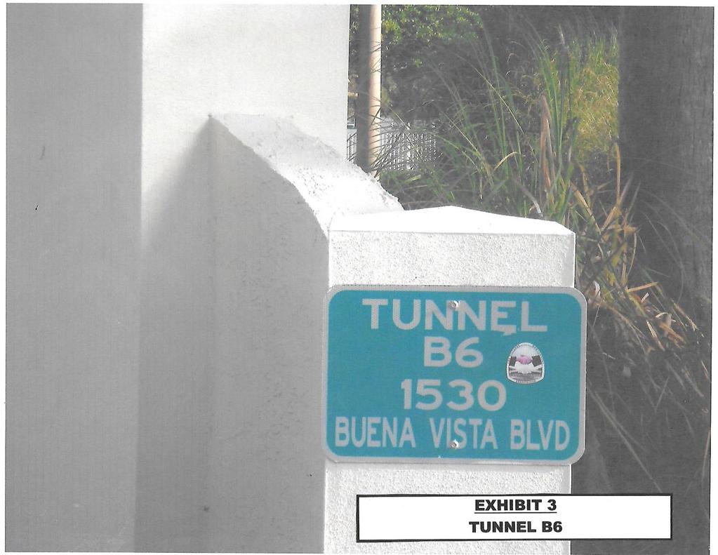
3 Tunnel B6.Tunnel B6 connects the Savannah Regional Recreation Center to the Village of Glenbrook under Buena Vista Boulevard at 1530 Buena Vista Boulevard (Exhibit 3). This tunnel is managed by VCDD 2. Access to this tunnel on the East end is via a two-way ramp that marks the termination of the main MMP which parallels El Camino Real. That ramp ends in an L as shown in Exhibit 3-1. Traffic entering or leaving the tunnel must make a 90 degree turn. There is no speed bump on the two-way segment. Access to this tunnel from the West end is via one-way Up and Down ramps connecting to the main MMP along Buena Vista Boulevard. The Down ramp is not protected by any speed bumps. Both ramps (Up and Down) are marked by a One Way sign at the ramp intersection with the main MMP (Exhibit 3-2). In addition, two speed bump segments at the lane divider of the tunnel inhibit any traffic (golf cart, skate boarders, or roller bladders) from going straight across the South tunnel entrance/exit (Exhibit 3-3). SUMMARY: This information clarifies the present standing of speed bumps along MMPs in VCDD 2. RECOMMENDATION: That the VCDD 2 representative to the MMPDG takes this information to the next scheduled MMPDG meeting as clarification to comments made during their December 2016 meeting. It is also recommended that our representative include this Position Paper as part of the agenda package for the next scheduled MMPDG meeting.

4

5

6

7

8

9

10
11

12

13

14
15
Community Development District Number Four
 PROGRAMMING PLAN TRANSPORTATION TRAILS NORTH OF CR 466 Community Development District Number Four The Villages, Florida Prepared for: The Village Center Community Development District Prepared by: Kimley-Horn
BOARD OF SUPERVISORS BUSINESS MEETING ACTION ITEM. Design Endorsement for Sterling Boulevard Extension
 Date of Meeting: July 20, 2017 # 6 BOARD OF SUPERVISORS BUSINESS MEETING ACTION ITEM SUBJECT: ELECTION DISTRICT: CRITICAL ACTION DATE: STAFF CONTACTS: Design Endorsement for Sterling Boulevard Extension
APPENDIX H. Transportation Impact Study
 APPENDIX H Transportation Impact Study BUENA VISTA LAGOON ENHANCEMENT PROJECT TRANSPORTATION IMPACT STUDY Prepared for: San Diego Association of Governments Prepared by: VRPA Technologies, Inc. 9520 Padgett
Railyard Alternatives & I-280 Boulevard Feasibility Study 1 RAILYARD ALTERNATIVES & I-280 BOULEVARD (RAB) FEASIBILITY STUDY
 FEASIBILITY STUDY") Railyard Alternatives & I-280 Boulevard Feasibility Study 1 RAILYARD ALTERNATIVES & I-280 BOULEVARD (RAB) FEASIBILITY STUDY RAB Citizen Working Group Meeting, August 1 st 2016 CITIZEN WORKING GROUP (CWG)
Railyard Alternatives & I-280 Boulevard Feasibility Study 1 RAILYARD ALTERNATIVES & I-280 BOULEVARD (RAB) FEASIBILITY STUDY RAB Citizen Working Group Meeting, August 1 st 2016 CITIZEN WORKING GROUP (CWG)
Purpose of Tonight s Meeting
 Purpose of Tonight s Meeting Point Dume Neighborhood Traffic Calming Project background, goals Resident Safety Concerns Existing Conditions Fact Sheets Map of Proposed Improvements Discussion Next Steps
Project Description: Georgia Department of Transportation Public Information Open House Handout PI#(s): , County: Muscogee
: , County: Muscogee") Why We Are Here: GDOT s Transportation Improvement Act (TIA) Office, the City of Columbus, and the project delivery team are here this evening to display and answer questions concerning the proposed roadway
Why We Are Here: GDOT s Transportation Improvement Act (TIA) Office, the City of Columbus, and the project delivery team are here this evening to display and answer questions concerning the proposed roadway
This corridor section will carry commuter trains from Wilsonville to Portland and Portland to Longview/Kelso.
 Alignment is double tracked for 80 mph commuter trains, 110 mph CHSR speeds between Bridgeport OR and 78 th Street in Vancouver WA. New alignment for freight trains will allow speeds up to 40 mph over
ALLEGAN COUNTY ROAD COMMISSION. Adopted by the Board of County Road Commissioners, December 28, Sign Policy
 ALLEGAN COUNTY ROAD COMMISSION Adopted by the Board of County Road Commissioners, December 28, 2016 Sign Policy Common/Policies/Sign Policy 2016 TABLE OF CONTENTS Page I. Purpose and Background.................................
Chapter 9 Recommended Locally Preferred Alternative and Alternatives for Evaluation in Draft SEIS/SEIR
 Chapter 9 Recommended Locally Preferred Alternative and Alternatives for Evaluation in Draft SEIS/SEIR 9.0 RECOMMENDED LOCALLY PREFERRED ALTERNATIVE AND ALTERNATIVES FOR EVALUATION IN DRAFT SEIS/SEIR
Charter Bus Staging and Pick-Up
 W Area Dr Charter Bus Staging and Pick-Up Event Charter Bus Loading Zone AirTrain Domestic Terminals: Level 1 (Arrivals) Designated spaces in Courtyards 1, 3, or 4 Terminal 2 International Terminal: Level
I-820 (East) Project Description. Fort Worth District. Reconstruct Southern I-820/SH 121 Interchange
 Project Description. Fort Worth District. Reconstruct Southern I-820/SH 121 Interchange") I-820 (East) Project Description Fort Worth District Reconstruct Southern I-820/SH 121 Interchange I-820 from approximately 2,000 feet north of Pipeline Road/Glenview Drive to approximately 3,200 feet
I-820 (East) Project Description Fort Worth District Reconstruct Southern I-820/SH 121 Interchange I-820 from approximately 2,000 feet north of Pipeline Road/Glenview Drive to approximately 3,200 feet
TECHNICAL MEMORANDUM. Part A: Introduction
 TECHNICAL MEMORANDUM To: David J. Decker Decker Properties, Inc. 5950 Seminole Centre Ct. Suite 200 Madison, Wisconsin 53711 608-663-1218 Fax: 608-663-1226 www.klengineering.com From: Mike Scarmon, P.E.,
SH 249 IN GRIMES COUNTY. Open House April 3, 2014
 SH 249 IN GRIMES COUNTY Open House April 3, 2014 Meeting Agenda Purpose of Meeting Today: Review the purpose and need for the SH 249 Grimes County project Review the proposed project and alternatives Discuss
Continued coordination and facilitation with City of Austin staff on documentation of processes to permit construction activities at the site.
 Project Manager Ed Collins LJA Engineering, Inc. Transportation Planning Manager 5316 Highway 290 West Austin Public Infrastructure Group Austin, TX 78735 (512) 762-6301 cell (512) 439-4757 office CARTS
Plan Check Policies and Guidelines
 VIII. TRAFFIC SIGNING AND STRIPING PLANS A. INTRODUCTION Traffic signing and striping plans are required for all General Plan Roads and any roadway that is 56-foot wide curb-to-curb (78 R/W) or wider.
Driveway Entrance Policy for Residential Properties - District 3 - All Wards
 Driveway Entrance Policy for Residential Properties - District 3 - All Wards (City Council on August 1, 2, 3 and 4, 2000, adopted this Clause, without amendment.) The North York Community Council recommends
HIGHWAY 28 FUNCTIONAL DESIGN
 HIGHWAY 28 FUNCTIONAL DESIGN PUBLIC OPEN HOUSE #1 WEDNESDAY, MARCH 12, 2014 Stantec Presenters: Brad Vander Heyden, Project Engineer Neal Cormack, Project Manager Dave Parker, Project Engineer Beth Thola,
PUBLIC INFRASTRUCTURE PROJECTS
 PUBLIC INFRASTRUCTURE PROJECTS FM 664 / OVILLA ROAD WIDENING & IMPROVEMENTS FM 664 / OVILLA ROAD CONNECTS US 287 WITH I-45 (SOURCE: TEXAS DEPARTMENT OF TRANSPORTATION. 2016 FM 664 / OVILLA ROAD WIDENING
GUIDE TO TRAFFIC MARSHALLING AT ExCeL LONDON
 Traffic Parking at Excel for contractors There are currently 54 individual parking bays for arctic size vehicles under the North side of the venue and these will be used for vehicles that require more
Public Meeting. City of Chicago Department of Transportation & Department of Housing and Economic Development
 Public Meeting City of Chicago Department of Transportation & Department of Housing and Economic Development Funded by Regional Transportation Authority September 12, 2011 In partnership with Presentation
HSR Vancouver WA to Camas Commuter Des, by R.N.
 This plan will show the new route for the Portland-Vancouver Junction Railroad. Remove the existing Portland-Vancouver Junction Railroad leg from the Northeast Hazel Dell Avenue curve to the Burlington
City of San Juan Capistrano Agenda Report
 12/16/214 82 City of San Juan Capistrano Agenda Report TO: FROM: DATE: SUBJECT: Karen P. Brust, City Manag4(?1-- Keith Van Der Maaten, P.E., Public Works and Utilities Directo Prepared by: George Alvarez,
FREQUENTLY ASKED QUESTIONS
 THE PROJECT Last updated on 9/8/16 FREQUENTLY ASKED QUESTIONS What s happening on Highway 169? The Minnesota Department of Transportation (MnDOT) is planning to rebuild and repair the infrastructure on
Sherman Oaks Community Traffic Plan
 Sherman Oaks is a community that is geographically bound by the Santa Monica mountains on its southern boundary, and the ever-expanding San Fernando Valley on its western, northern, and eastern boundaries.
CTA Capital Construction Update May 17, 2007
 Block 37 Signals Project Brown Line Howard CTA Capital Construction Update May 17, 2007 1 Capital Construction Update Agenda Howard Station Reconstruction Brown Line Capacity Expansion Project Block 37
Central Park Drives Traffic Management Overview
 Central Park Drives Traffic Management Overview Spring 2015 New York City Department of Transportation Existing Traffic Management From Labor Day thru Last Day of NYC Public School: 8-10 AM weekdays (Southbound)
Develop ground transportation improvements to make the Airport a multi-modal regional
 Project Overview TRANSPORTATION IMPROVEMENTS WHAT ARE THE PROJECT GOALS? Transportation transportation hub. Develop ground transportation improvements to make the Airport a multi-modal regional Land Use
Characterization of Combined Use of County Road Segment
 Department of Public Works Inyo County, California Characterization of Combined Use of County Road Segment Segment Name: _Lone Pine No. 1_ Purpose: Which of the following does the combined-use segment
Chapter 8.0 PROPOSED CAPITAL IMPROVEMENT PROGRAM
 Chapter 8.0 PROPOSED CAPITAL IMPROVEMENT PROGRAM This chapter presents the proposed Capital Improvement Program (CIP) for the District based on the findings of this Master Plan. The Master Plan primarily
soha SHERMAN OAKS HOMEOWNERS ASSOCIATION Post Office Box 5223 Sherman Oaks, California Information: (818)
") Officers President Richard H. Close Vice President Matt Epstein Vice President Jules Feir Treasurer Chuck Betz Secretary John Isen Founded in 1964 soha SHERMAN OAKS HOMEOWNERS ASSOCIATION Post Office Box
Officers President Richard H. Close Vice President Matt Epstein Vice President Jules Feir Treasurer Chuck Betz Secretary John Isen Founded in 1964 soha SHERMAN OAKS HOMEOWNERS ASSOCIATION Post Office Box
Engineering Report: Shasta-Trinity National Forest. South Fork Management Unit. Analysis of. National Forest System Road 30N44
 Engineering Report: Shasta-Trinity National Forest South Fork Management Unit Analysis of National Forest System Road 30N44 (milepost 0.00 to 0.40) for Motorized Mixed Use Designation Forest: Shasta-Trinity
Technical Memorandum. To: From: Date: October 14 th, 2018 Project #: 1302 Project Name: Subject: Distribution:
 Technical Memorandum To: Tom Hanrahan Jeff Sharp From: Date: October 14 th, 2018 Project #: 1302 Project Name: Subject: Distribution: Barrie Lockhart Road LP Conformity Review Scott Young Sorbara Group
BROWARD BOULEVARD CORRIDOR TRANSIT STUDY
 BROWARD BOULEVARD CORRIDOR TRANSIT STUDY FM # 42802411201 EXECUTIVE SUMMARY July 2012 GOBROWARD Broward Boulevard Corridor Transit Study FM # 42802411201 Executive Summary Prepared For: Ms. Khalilah Ffrench,
370 Queen Elizabeth Drive Transportation Overview
 December 8, 2014 OUR REF: TO3193TOA BY EMAIL: Ashley@rocahomes.ca 2253644 Ontario Inc. c/o BassCon 24 George Street West Ottawa, ON K1S 3J2 Attention: Ashley Lepine Dear Ashley: Re: 370 Queen Elizabeth
FREQUENTLY ASKED QUESTIONS
 THE PROJECT Last updated on 2/19/16 FREQUENTLY ASKED QUESTIONS What s happening on Highway 169? The Minnesota Department of Transportation (MnDOT) is planning to rebuild and repair the infrastructure on
Oakbrook Village Plaza City of Laguna Hills
 Oakbrook Village Plaza City of Laguna Hills Traffic Impact Analysis Prepared by: HDR Engineering 3230 El Camino Real, Suite 200 Irvine, CA 92602 October 2012 Revision 3 D-1 Oakbrook Village Plaza Laguna
LAWRENCE TRANSIT CENTER LOCATION ANALYSIS 9 TH STREET & ROCKLEDGE ROAD / 21 ST STREET & IOWA STREET LAWRENCE, KANSAS
 LAWRENCE TRANSIT CENTER LOCATION ANALYSIS 9 TH STREET & ROCKLEDGE ROAD / 21 ST STREET & IOWA STREET LAWRENCE, KANSAS TRAFFIC IMPACT STUDY FEBRUARY 214 OA Project No. 213-542 TABLE OF CONTENTS 1. INTRODUCTION...
CITY OF AVON PARK Highlands County, Florida Office of the City Manager 110 East Main Street Avon Park, Florida 33825
 CITY OF AVON PARK Highlands County, Florida Office of the City Manager 110 East Main Street Avon Park, Florida 33825 JOINT WORKSHOP AVON PARK CITY COUNCIL & PLANNING AND ZONING BOARD CITY COUNCIL CHAMBERS
Corridor Sketch Summary
 Corridor Sketch Summary SR 241: I-82 Jct (Sunnyside) to SR 24 Jct Corridor Highway No. 241 Mileposts: 7.53 to 25.21 Length: 17.65 miles Corridor Description The seventeen and one-half mile corridor begins
Public Information Workshop
 Public Information Workshop Charlotte County-Punta Gorda MPO - Meeting Rooms A and B March 29, 2018 Welcome to the Public Information Workshop for Harborview Road Project Development and Environment (PD&E)
AGENDA REPORT. TO: Office ofthe City Administrator ATTN: Deborah Edgerly FROM: Community and Economic Development Agency DATE: June 24, 2008
 CITY OF AGENDA REPORT OAKLAND TO: Office ofthe City Administrator ATTN: Deborah Edgerly FROM: Community and Economic Development Agency DATE: June 24, 2008 RE: Resolution Approving: I) The Removal Of A
TRAFFIC-CALMING SOLUTIONS A SURVEY OF SAFETY PROFESSIONALS
 TRAFFIC-CALMING SOLUTIONS A SURVEY OF SAFETY PROFESSIONALS SURVEY TRAFFIC CALMING OPTIONS In January 27, over 1 traffic engineers, police officers and safety professionals from around the United States
Capital Improvement Plan Review
 City of Manhattan Beach Public Works Department Fiscal Year 2014/2015 2018/2019 Capital Improvement Plan Review Community Meeting: April 10, 2014 Objectives Creating the Capital Improvement Plan Funding
Foster Ave and Harlem Ave. RLR Crash Data and Analysis
 Foster Ave and Harlem Ave RLR Crash Data and Analysis The table and chart below show a summary of motor vehicle crashes at the intersection of Foster Ave and Harlem Ave over a span of 4 years.
Parks and Transportation System Development Charge Methodology
 City of Sandy Parks and Transportation System Development Charge Methodology March, 2016 Background In order to implement a City Council goal the City of Sandy engaged FCS Group in January of 2015 to update
Speed measurements were taken at the following three locations on October 13 and 14, 2016 (See Location Map in Exhibit 1):
:") 2709 McGraw Drive Bloomington, Illinois 61704 p 309.663.8435 f 309.663.1571 www.f-w.com www.greennavigation.com November 4, 2016 Mr. Kevin Kothe, PE City Engineer City of Bloomington Public Works Department
2709 McGraw Drive Bloomington, Illinois 61704 p 309.663.8435 f 309.663.1571 www.f-w.com www.greennavigation.com November 4, 2016 Mr. Kevin Kothe, PE City Engineer City of Bloomington Public Works Department
I-4 Beyond the Ultimate. Florida Transportation Builders Association January 18, 2019
 I-4 Beyond the Ultimate Florida Transportation Builders Association January 18, 2019 FDOT District 5 Improving Mobility & Safety in Central Florida FDOT District 5 is: Designing and building a better Interstate
Heavy Truck Conflicts at Expressway On-Ramps Part 1
 Heavy Truck Conflicts at Expressway On-Ramps Part 1 Posting Date: 7-Dec-2016; Revised 14-Dec-2016 Figure 1: Every day vast numbers of large and long trucks must enter smoothly into high speed truck traffic
I-405 Sepulveda Pass Improvements Project
 I-405 Sepulveda Pass Improvements Project Community Meeting November 15, 2012 1 Wilshire Segment Overview of Wilshire Segment There are a total of 23 bridges being constructed on this project; almost half
Plan Check Policies and Guidelines
 Plan Check Policies and Guidelines VII. A. INTRODUCTION Traffic signing and striping plans are required for all General Plan Roads and any roadway that is 56-foot wide curb-to-curb (78 R/W) or wider. Transportation
STATE ND PROJECT NO. CP 0883 (14) & CP 1152 (14) SHEET NO. TOTAL SHEETS 9 31 SIGN NUMBER SIGN SIZE DESCRIPTION AMOUNT REQUIRED UNITS PER AMOUNT UNITS
 & CP 1152 (14) SHEET NO. TOTAL SHEETS 9 31 SIGN NUMBER SIGN SIZE DESCRIPTION AMOUNT REQUIRED UNITS PER AMOUNT UNITS") STATE ND PROJECT NO. CP 0883 (14) & CP 1152 (14) SHEET NO. TOTAL SHEETS 9 31 SIGN NUMBER SIGN SIZE DESCRIPTION AMOUNT REQUIRED UNITS PER AMOUNT UNITS SUB TOTAL SIGN NUMBER SIGN SIZE DESCRIPTION AMOUNT
STATE ND PROJECT NO. CP 0883 (14) & CP 1152 (14) SHEET NO. TOTAL SHEETS 9 31 SIGN NUMBER SIGN SIZE DESCRIPTION AMOUNT REQUIRED UNITS PER AMOUNT UNITS SUB TOTAL SIGN NUMBER SIGN SIZE DESCRIPTION AMOUNT
Truck Traffic Impact Analysis
 Truck Traffic Impact Analysis FOR Proposed Demolition Project AT 3300 Panorama Drive Morro Bay, CA Prepared for Rhine LP & CVI Group, LLC Prepared by 1998 Santa Barbara Avenue, Suite 200 San Luis Obispo,
Station Evaluation. Durham-Orange Light Rail Transit Project Spring 2012
 Station Evaluation Durham-Orange Light Rail Transit Project Spring 2012 Key Ingredients for Station Development Platform Designs UNC Hospitals Station The UNC Hospitals Station Option D would be the westerly
Ambleside Boat Launch Closure. Ramp to Close by December 31, 2016
 Ambleside Boat Launch Closure Ramp to Close by December 31, 2016 District of West Vancouver approved the Ambleside Waterfront Concept Plan June 13 2016. The otio approved dire ts staff to: Close vehicular
NORTH HOUSTON HIGHWAY IMPROVEMENT PROJECT (NHHIP)
") NORTH HOUSTON HIGHWAY IMPROVEMENT PROJECT (NHHIP) Project Overview Briefing Packet March 2017 PROJECT OVERVIEW Environmental Impact Statement (EIS) Project divided into 3 Segments Segment 1: Beltway 8
NORTH HOUSTON HIGHWAY IMPROVEMENT PROJECT (NHHIP) Project Overview Briefing Packet March 2017 PROJECT OVERVIEW Environmental Impact Statement (EIS) Project divided into 3 Segments Segment 1: Beltway 8
MEMO 1. SITE LOCATION AND EXISTING USE. 2.1 Vehicle Access. Table 1: Vehicle Parking Requirements and Proposed Supply
 MEMO DATE: March 22, 2016 PROJECT O: 4241-44 PROJECT: 1550 Alberni Street SUBJECT: Transportation Design Rationale for Rezoning Application (Update with Design Package) TO: Dave Leung, 1550 Alberni Limited
TRAFFIC PARKING ANALYSIS
 TRAFFIC PARKING ANALYSIS NAPA FLEA MARKET COUNTY OF NAPA Prepared for: Tom Harding Napa-Vallejo Flea Market 33 Kelly Road American Canyon, CA 9453 Prepared by: 166 Olympic Boulevard, Suite 21 Walnut Creek,
Citizens Committee for Facilities
 Citizens Committee for Facilities AGENDA Thursday, December 11, 2014 City Council Chambers 305 3 rd Avenue East -Twin Falls, Idaho 11:30 A.M. AGENDA ITEMS Purpose By 1. Discussion and possible action on
Purpose and Need Report
 Purpose and Need Report State Highway (SH) 29 From Southwestern Boulevard to SH 95 Williamson County, Texas (CSJ: 0337-02-045) Prepared by Blanton & Associates, Inc. Date: November, 2015 The environmental
New Jersey Turnpike Authority Interchange 6 to 9 Widening Program
 New Jersey Turnpike Authority Interchange 6 to 9 Widening Program Tuesday, September 18, 2007 Public Hearings: Time: 5:00 PM - 8:00 PM Wednesday, September 19, 2007 Senior Center 3 Municipal Drive Bordentown,
Construction Realty Co.
 MEMORANDUM TO: FROM : Jeff Pickus Construction Realty Co. Luay R. Aboona, PE Principal 9575 West Higgins Road, Suite 400 Rosemont, Illinois 60018 p: 847-518-9990 f: 847-518-9987 DATE: May 22, 2014 SUBJECT:
AVE MARIA STEWARDSHIP COMMUNITY DISTRICT
 AVE MARIA STEWARDSHIP COMMUNITY DISTRICT GOLF CART USE AGREEMENT To receive a registration decal, please complete the AMSCD Golf Cart Use Agreement and return the form to: AVE MARIA STEWARDSHIP COMMUNITY
PN /21/ SURFACE SMOOTHNESS REQUIREMENTS FOR PAVEMENTS
 PN 420-10/21/2016 - SURFACE SMOOTHNESS REQUIREMENTS FOR PAVEMENTS DESCRIPTION: The surface tolerance specification requirements are modified as follows for all pavements of constant width with at least
Attachment D Environmental Justice and Outreach
 Attachment D Environmental Justice and Outreach ATTACHMENT D Environmental Justice and Outreach Indicate whether the project will have disproportionately high and adverse impacts on minority or low income
PERFORMANCE ACTIVITY 603 SIGNS
 PERFORMANCE ACTIVITY 603 SIGNS WORK DESCRIPTION 3 WORK DESCRIPTION 4 WORK DESCRIPTION 6 New Install Maintenance / Replace Temporary 603 SIGNS ACTIVITY DESCRIPTION Install new signs and maintain and replace
Figure 2-14: Existing Bus Routing at Irwindale Station
 494 W oothill Blvd 69 N Irwindale Ave 185 Irwindale E 1st St 3 6 feet igure 2-14: Existing Bus Routing at Irwindale 39 Proposed Bus Route 494 W oothill Blvd Proposed Discontinued Bus Route Proposed New
Traffic Engineering Study
 Traffic Engineering Study Bellaire Boulevard Prepared For: International Management District Technical Services, Inc. Texas Registered Engineering Firm F-3580 November 2009 Executive Summary has been requested
April 2014: Capital Improvements Update. through $ 102,233,755 Available Funding through 2019 $ 149,764,558. Staff s Recommendation
 Capital Improvements Update April 2014: Pl dp j t Planned Projects through 2019 - $ 102,233,755 Available Funding through 2019 $ 149,764,558 pp p,, Un-appropriated - $ 47,530,803 Staff s Recommendation
SCAN Land Use and Transportation Committee Report June 10, 2015
 DRAFT DRAFT DRAFT Exhibit A to SCAN Minutes - June 10, 2015 SCAN Land Use and Transportation Committee Report June 10, 2015 Gaiety Hollow In April the Committee provided testimony in support of the Lord
Kasold Drive 15 th Street to Clinton Parkway Road Reconstruction Project
 Kasold Drive 15 th Street to Clinton Parkway Road Reconstruction Project Public Information Meeting When: Where: Monday, August 23, 2004, 7:00 p.m. Police Department Training Room 4820 W. 15 th Street
1. The purpose of this report is to seek the Board s support to set new speed limits on the roads described in this report (refer to attached plans).
.") 7. CHRISTCHURCH CITY PROPOSED NEW SPEED LIMITS General Manager responsible: General Manager City Environment, DDI: 941-8656 Officer responsible: Transport and Greenspace Manager Author: Malcolm Taylor,
7. CHRISTCHURCH CITY PROPOSED NEW SPEED LIMITS General Manager responsible: General Manager City Environment, DDI: 941-8656 Officer responsible: Transport and Greenspace Manager Author: Malcolm Taylor,
Challenges in a Post-Katrina Environment East-West Corridor Project Overview February, 2007
 EAST-WEST CORRIDOR Challenges in a Post-Katrina Environment East-West Corridor Project Overview February, 2007 Presentation Agenda Project Overview / Purpose and Need Highway Component Transit Component
Public Information Packet FY Fargo-Moorhead Metropolitan Transportation Improvement Program (TIP)
") Public Information Packet FY - Fargo-Moorhead Metropolitan Transportation Improvement Program (TIP) Comment Form Annual Element TIP Projects - TIP Projects Year - Metropolitan Transportation Improvement
Public Information Packet FY - Fargo-Moorhead Metropolitan Transportation Improvement Program (TIP) Comment Form Annual Element TIP Projects - TIP Projects Year - Metropolitan Transportation Improvement
City of Alameda Capital Improvement Projects Fiscal Years Proposed Project Descriptions
 Drainage Southshore Lagoon Dredging $525,000 74 Prepare drawings and design deepening or removal of sediment from lagoons. Marina Village Park $580,500 70 Resolve the drainage issue in the Marina Village
DATE: March 21, 2017 REPORT NO. PW TYPE OF REPORT CONSENT ITEM [ ] ITEM FOR CONSIDERATION [ X ] 2.0 TOPIC
![DATE: March 21, 2017 REPORT NO. PW TYPE OF REPORT CONSENT ITEM [ ] ITEM FOR CONSIDERATION [ X ] 2.0 TOPIC](/thumbs/88/115267053.jpg "DATE: March 21, 2017 REPORT NO. PW TYPE OF REPORT CONSENT ITEM [ ] ITEM FOR CONSIDERATION [ X ] 2.0 TOPIC") PUBLIC WORKS COMMISSION PUBLIC WORKS COMMISSION DATE: March 21, 2017 REPORT NO. PW2017-022 TO: FROM: Chair and Members Committee of the Whole Operations and Administration E. (Beth) Goodger, General Manager
PUBLIC WORKS COMMISSION PUBLIC WORKS COMMISSION DATE: March 21, 2017 REPORT NO. PW2017-022 TO: FROM: Chair and Members Committee of the Whole Operations and Administration E. (Beth) Goodger, General Manager
King County Metro. Columbia Street Transit Priority Improvements Alternative Analysis. Downtown Southend Transit Study. May 2014.
 King County Metro Columbia Street Transit Priority Improvements Alternative Analysis Downtown Southend Transit Study May 2014 Parametrix Table of Contents Introduction... 1 Methodology... 1 Study Area...
TRAFFIC IMPACT STUDY VICDOM BROCK ROAD PIT EXPANSION
 TRAFFIC IMPACT STUDY VICDOM BROCK ROAD PIT EXPANSION TOWNSHIP OF UXBRIDGE P/N 05-1993 June 2011 Revised -August 2011 Prepared by: Skelton, Brumwell & Associates Inc. 93 Bell Farm Road, Suite 107 Barrie,
Waterfront Transit Reset Phase 2 Study. Public Information & Consultation Meetings September 18 & 26, 2017
 Waterfront Transit Reset Phase 2 Study Public Information & Consultation Meetings September 18 & 26, 2017 2 Agenda 6:00 Open House 6:30 Agenda Review, Opening Remarks and Introductions 6:40 Study Overview
Harlem Avenue between 63 rd and 65 th
 Harlem Avenue between 63 rd and 65 th Community Advisory Group Meeting #3 December 1, 2017 Bedford Park Public Library 1 Meeting Agenda 1. Welcome/Introductions (3 mins) 2. Project Overview and Re-Cap
Chapter 7: Corridor Visions
 Chapter 7: Corridor Visions (see also Appendix 7 for Details) January 24, 2008 NOTE: This document has been prepared using Federal funding from the United States Department of Transportation. The United
Request Modification of Conditions (Motor Vehicle Rentals) Staff Recommendation Approval. Staff Planner Jonathan Sanders
 Staff Recommendation Approval. Staff Planner Jonathan Sanders") Applicant & Owner Public Hearing March 14, 2018 City Council Election District Centerville Agenda Item 4 Request Modification of Conditions (Motor Vehicle Rentals) Staff Recommendation Approval Staff Planner
Applicant & Owner Public Hearing March 14, 2018 City Council Election District Centerville Agenda Item 4 Request Modification of Conditions (Motor Vehicle Rentals) Staff Recommendation Approval Staff Planner
Committee Report. Transportation Committee. Business Item No
 Committee Report Business Item No. 2015-280 Transportation Committee For the Metropolitan Council meeting of December 9, 2015 Subject: METRO Blue Line Extension (Bottineau Light Rail Transit) Revised Scope
Table of Contents INTRODUCTION... 3 PROJECT STUDY AREA Figure 1 Vicinity Map Study Area... 4 EXISTING CONDITIONS... 5 TRAFFIC OPERATIONS...
 Crosshaven Drive Corridor Study City of Vestavia Hills, Alabama Table of Contents INTRODUCTION... 3 PROJECT STUDY AREA... 3 Figure 1 Vicinity Map Study Area... 4 EXISTING CONDITIONS... 5 TRAFFIC OPERATIONS...
Capital Improvement Program (CIPs) City of Industry FY 2017/18 Adopted Budget
 City of Industry FY 2017/18 Adopted Budget") Capital Improvement Program (CIPs) City of Industry FY 2017/18 155 FY 2017/18 156 City of Industry, California Capital Improvement Program Overview of Department The Capital Improvement Program (CIP) is
Capital Improvement Program (CIPs) City of Industry FY 2017/18 155 FY 2017/18 156 City of Industry, California Capital Improvement Program Overview of Department The Capital Improvement Program (CIP) is
Clean Harbors Canada, Inc.
 Clean Harbors Canada, Inc. Proposed Lambton Landfill Expansion Environmental Assessment Terms of Reference Transportation Assessment St. Clair Township, Ontario September 2009 itrans Consulting Inc. 260
Chapter 4 : THEME 2. Transportation
 Chapter 4 : THEME 2 Strengthen connections to keep the Central Area easy to reach and get around 55 Figure 4.2.1 Promote region-wide transit investments. Metra commuter rail provides service to the east,
Danger CAUTION - RR tracks (2 sets) Food SERVICES - Quik Mart on left
 Food SERVICES - Quik Mart on left") Dist Day Leg PAC TOUR 600k Dist (km) Type Instruction ORGANIZER - Susan Notorangelo - (612) 804-9970 START - TUCSON 0.0 0.0 0.0 Country Inn and Suites - 6681 South Tucson Boulevard, Tucson, AZ 85756-0.0
Dist Day Leg PAC TOUR 600k Dist (km) Type Instruction ORGANIZER - Susan Notorangelo - (612) 804-9970 START - TUCSON 0.0 0.0 0.0 Country Inn and Suites - 6681 South Tucson Boulevard, Tucson, AZ 85756-0.0
IMPROVEMENT CONCEPTS
 IMPROVEMENT CONCEPTS for the South Novato Transit Hub Study Prepared by: January 11, 2010 DKS Associates With Wilbur Smith Associates IMPROVEMENT CONCEPTS Chapter 1: Introduction 1. INTRODUCTION The strategic
Table Existing Traffic Conditions for Arterial Segments along Construction Access Route. Daily
 5.8 TRAFFIC, ACCESS, AND CIRCULATION This section describes existing traffic conditions in the project area; summarizes applicable regulations; and analyzes the potential traffic, access, and circulation
Traffic Impact Analysis. Alliance Cole Avenue Residential Site Dallas, Texas. Kimley-Horn and Associates, Inc. Dallas, Texas.
 Traffic Impact Analysis Alliance Cole Avenue Residential Site Dallas, Texas February 15, 2018 Kimley-Horn and Associates, Inc. Dallas, Texas Project #064524900 Registered Firm F-928 Traffic Impact Analysis
Traffic Management Plan and Queuing Analysis Lakehill Preparatory School Z Hillside Drive, Dallas, TX October 27, 2015
 Traffic Management Plan and Queuing Analysis Lakehill Preparatory School Z145-235 2720 Hillside Drive, Dallas, TX October 27, 2015 Introduction: The Lakehill Preparatory School is located on the northeast
Confederation Line Stage 1 and 2. Our Lady of Fatima Church May 10 th, 2018
 Confederation Line Stage 1 and 2 Our Lady of Fatima Church May 10 th, 2018 Agenda Confederation Line Stage 1 Overview project, consortium, vehicles Confederation Line Stage 2 Overview project, benefits
The Re:Queen and Sparks Traffic Brief - Addendum #2
 June 11, 2015 Ashcroft Homes 18 Antares Drive Ottawa, ON K2E 1A9 EMAIL: mpham@ashcrofthomes.com Attention: May Pham Development Planner Dear May, Re: The Re:Queen and Sparks Traffic Brief - Addendum #2
The minimum number of accessory off-street parking spaces. shall conform to the requirements of the Table of General
 ARTICLE VII Parking and Loading 1. Conformity with Use Table; exceptions. The minimum number of accessory off-street parking spaces shall conform to the requirements of the Table of General Use Regulations,
CART SAFETY and LOSS PREVENTION PROGRAM MAY 2018
 CART SAFETY and LOSS PREVENTION PROGRAM MAY 2018 A. SCOPE AND APPLICATION The Cart Safety Program and Loss Prevention Program has been established to prevent loss, provide proper maintenance and ensure
4 Circulation & Transportation
 4.1 Mobility Network The mobility network at the new St. Paul s hospital and health campus is comprised of an interconnected system of sidewalks, cycle paths, transit routes and roadways. Figure 4-1: Indicative
To: File From: Adrian Soo, P. Eng. Markham, ON File: Date: August 18, 2015
 Memo To: From: Adrian Soo, P. Eng. Markham, ON : 165620021 Date: Reference: E.C. Row Expressway, Dominion Boulevard Interchange, Dougall Avenue Interchange, and Howard 1. Review of Interchange Geometry
CAL STATE LA ELECTRIC CART SAFETY. Richard Brennan, Health & Safety Coordinator Risk Management & EHS Office
 CAL STATE LA ELECTRIC CART SAFETY Richard Brennan, Health & Safety Coordinator Risk Management & EHS Office The Main Points Electric Carts: departmental authorization and training traffic laws restrictions
Welcome. Please Sign In
 Welcome South Bay Bus Rapid Transit (BRT) Draft Environmental Impact Report (DEIR) Public Meeting Please Sign In Please comment in any of the following manners: 1. Submit a comment form 2. Provide verbal
PAPER FOR AREMA 2004 ANNUAL CONFERENCE LOS ANGELES UNION STATION RUN-THROUGH TRACKS. Paul Mak, PE, SE - DMJM HARRIS
 1 PAPER FOR AREMA 2004 ANNUAL CONFERENCE LOS ANGELES UNION STATION RUN-THROUGH TRACKS Paul Mak, PE, SE - DMJM HARRIS 515 S. Flower Street 9th Floor, Los Angeles, CA 90071. Tel 213-593-8337 Fax 213-593-8622