Strategic Transport Modelling Assessment (Ultimate Scenario)
|
|
|
- Stewart Hoover
- 5 years ago
- Views:
Transcription

1 Strategic Transport Modelling Assessment (Ultimate Scenario) McPherson, Croskell and Minta Farm Precincts CG447 Prepared for Metropolitan Planning Authority 3 August 25
2 Document Information Prepared for Metropolitan Planning Authority Project Name File Reference CG447REPF2.docx Job Reference CG447 Date 3 August 25 Contact Information Cardno Victoria Pty Ltd Trading as Cardno ABN Level 4 5 Swanston Street Melbourne Victoria 3 Australia Telephone: (3) Facsimile: (3) International: victoria@cardno.com.au Document Control Version Date Author Author Initials Reviewer D 3//5 Erna Sukardi / Matthew Mudge Manesha Ravji F 7/8/5 Erna Sukardi / Matthew Mudge Manesha Ravji F2 3/8/5 Erna Sukardi / Matthew Mudge Manesha Ravji Reviewer Initials Cardno. Copyright in the whole and every part of this document belongs to Cardno and may not be used, sold, transferred, copied or reproduced in whole or in part in any manner or form or in or on any media to any person other than by agreement with Cardno. This document is produced by Cardno solely for the benefit and use by the client in accordance with the terms of the engagement. Cardno does not and shall not assume any responsibility or liability whatsoever to any third party arising out of any use or reliance by any third party on the content of this document. 3 August 25 Cardno i
3 Table of Contents Introduction. Overview.2 Key Objectives.3 Referenced Documents 2.4 Interim (22) vs. Ultimate (24) Analysis 2 2 Study Area 3 2. South East Growth Corridor McPherson (PSP 55) Croskell (PSP 5) Minta Farm (PSP ) 3 Victorian Integrated Transport Model (VITM) 8 3. Victorian Integrated Transport Model (VITM) South East Growth Corridor VITM Model Limitations 8 4 Model Review and Development 9 4. Preamble PSPs as coded in AECOM VITM Road Networks Review 4.3. Overview Interim Road Network Review Ultimate Road Network Review Zone System Review Modelled Land Uses 7 5 Ultimate Modelling Results 8 5. Introduction Review of VITM Traffic Generation VITM Traffic Generation First Principles Generation Rates Comparison of VITM and First Principles Volume Analysis McPherson (PSP 55) North-south Volumes East-west Volumes Croskell (PSP 5) Minta Farm (PSP ) 24 Summary and Conclusions 25. Summary 25.2 Conclusions 25 Appendices Appendix A Draft Urban Structures Appendix B VITM Ultimate Road Network Review Appendix C Zone Structure Refinements Appendix D Modelled Land Uses 3 August 25 Cardno ii
4 Appendix E 24 Ultimate Output Volumes Tables Table 2- McPherson (PSP 55) Anticipated Development Yields 4 Table 2-2 Croskell PSP (PSP 5) Anticipated Development Yields Table 2-3 Minta Farm (PSP ) Anticipated Development Yields 7 Table 4- Land Use Refinement 7 Table 5- Ultimate Scenario VITM Trip Generation Summary (Year 24) 8 Table 5-2 First Principles Traffic Generation - Ultimate Scenario (Year 24) 9 Table 5-3 VITM versus First Principles Assessment 2 Figures Figure - Location of PSPs within the South East Growth Corridor Figure 2- South East Growth Corridor 3 Figure 2-2 McPherson (PSP 55) Draft Urban Structure 4 Figure 2-3 Croskell PSP Draft Urban Structure 5 Figure 2-4 Minta Farm PSP Draft Urban Structure Figure 4- PSP Localities 9 Figure 4-2 PSP Locations in AECOM VITM Figure 4-3 VITM Area Reviewed and Refined by Cardno Figure 4-4 AECOM Interim (22) Scenario Road Network Coding 2 Figure 4-5 Interim (22) Road Network Coding Changes Proposed by Cardno 2 Figure 4- AECOM Ultimate (24) Scenario Network Coding 3 Figure 4-7 AECOM Zone System 4 Figure 4-8 Zone System Changes Proposed by Cardno McPherson (PSP 55) 5 Figure 4-9 Zone System Changes Completed by Cardno Croskell (PSP 5) Figure 4- Zone System Changes Proposed by Cardno Minta Farm (PSP ) 7 Figure 5- Daily VITM Plot McPherson (PSP 55) 2 Figure 5-2 Daily VITM Plot Croskell (PSP 5) 23 Figure 5-3 Daily VITM Plot Minta Farm (PSP ) 24 3 August 25 Cardno iii
 is preparing draft Urban Structures to inform the Precinct Structure Plans (PSPs) of McPherson (PSP 55), Croskell (PSP 5) and Minta Farm (PSP ).")
5 Introduction. Overview The Metropolitan Planning Authority (MPA) is preparing draft Urban Structures to inform the Precinct Structure Plans (PSPs) of McPherson (PSP 55), Croskell (PSP 5) and Minta Farm (PSP ). The location of the PSP areas within the context of the South East Growth Corridor is outlined in Figure -. Figure - Location of PSPs within the South East Growth Corridor Source: MPA Website (PSP Status Map dated November 24) As part of the preparation of the draft Urban Structures, the MPA commissioned Cardno to undertake strategic transport modelling. The outputs of the strategic modelling will be used as an input into further modelling to determine the road and intersection configurations that will be included in the PSPs and subsequent Development Contributions Plans (DCPs), or similar..2 Key Objectives The strategic modelling was completed using the MPA s South East Growth Corridor version of the Victorian Integrated Transport Model (VITM) and the key objectives of the study are outlined as follows: > Review the latest version for the South East Growth Corridor VITM (i.e. the model developed for the Thompsons Road, Clyde Creek and Casey Fields South PSPs), focusing on the PSP areas for McPherson, Croskell and Minta Farm and the road network surrounding the PSP areas. > Update the VITM to reflect the road network and land uses envisaged for the subject PSPs. > Run the updated VITM to assess the anticipated interim (22) and ultimate (24) traffic volumes on the network. 3 August 25 Cardno
6 .3 Referenced Documents In preparing this report, the following data sources and reports have been considered: > Draft Urban Structures for the McPherson (PSP 55), Croskell (PSP 5) and Minta Farm (PSP ) PSPs as provided by the MPA. > The Thompsons Road, Clyde Creek and Casey Fields South (Residential) PSP 53, 54 & 57. Traffic Modelling report prepared by AECOM, Revision A, dated 4 April 24. > MPA s South East Growth Corridor VITM Version VITM22_V2423_THOMPSONS_v2. > Other documents and data sources as nominated throughout this report..4 Interim (22) vs. Ultimate (24) Analysis Both interim and ultimate traffic volumes will eventually be assessed as part of this study. The interim volumes represent the + year development scenario (~22) and the ultimate volumes the +3 year development scenario (~24). The interim volumes will be refined and used to inform the intersection works up to the interim scenario for inclusion in the DCPs and represent the works that will be used by the future community of the PSP area, whilst the ultimate volumes will be used to validate the ultimate road reservation requirements (including flaring requirements at intersections). This report focuses on the ultimate VITM analysis, following agreement on the outcomes of the ultimate modelling, the interim modelling will commence in accordance with the study brief. 3 August 25 Cardno 2
 The South East Growth Corridor Plan is an integrated land use and transport plan that provides a strategy")
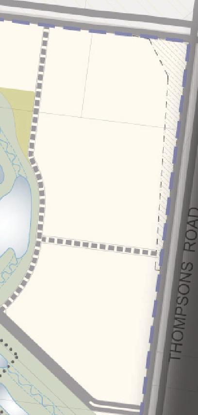
7 2 Study Area 2. South East Growth Corridor The South East Growth Corridor Plan and the location of the subject PSPs within the corridor are outlined in Figure 2-. Figure 2- South East Growth Corridor Source: MPA Website (South East Growth Corridor Plan) The South East Growth Corridor Plan is an integrated land use and transport plan that provides a strategy for the development of Melbourne s South East Growth Corridor over the coming decades. Further detail on the subject PSPs is provided in the following sub sections. 2.2 McPherson (PSP 55) McPherson (PSP 55) covers an area of approximately 952 hectares and is made up of farming land. It is located to the east of the Thompsons Road (PSP 53) and Clyde Creek (PSP 54) PSP areas. The PSP is generally bounded by Bells Road / Smiths Lane to the west, Thompsons Rd to the north, Cardinia Creek to the east, and Ballarto Road to the south. The draft Urban Structure for the PSP is shown in Figure 2-2 (with an enlarged version included in Appendix A). 3 August 25 Cardno 3

8 Figure 2-2 McPherson (PSP 55) Draft Urban Structure As outlined in Figure 2-2, the draft Urban Structure for McPherson includes residential, Local Town Centre (LTC), and school uses in addition to community and open space uses. The anticipated development yields envisaged by the draft Urban Structure were provided by the MPA and are outlined in Table 2-. Table 2- McPherson (PSP 55) Anticipated Development Yields PSP Population Households Enrolment Retail Jobs Non- Retail Total Jobs Jobs McPherson (PSP 55) 35,5 2,52 2, ,42 The key features of the road network included in the draft Urban Structure are summarised as follows: 3 August 25 Cardno 4

9 > Smiths Lane along the western precinct boundary which is anticipated to operate as a Connector Street; > Two north-south Connector Streets, one located east of Bells Rd and the other east of Smiths Lane; > Three east-west Connector Streets which extend the Connector Streets proposed in the adjacent Thompsons Road and Clyde Creek PSPs. > The extension of Patterson Road, an east-west Arterial Road through the precinct. > A number of internal local Access Streets. 2.3 Croskell (PSP 5) Croskell (PSP 5) covers an area of approximately 275 hectares and is located to the south of Cranbourne North Stages and 2 (PSPs 5 and ), the west of Thompsons Road (PSP 53), and north of Cranbourne East (PSP 4). The PSP is generally bound by Thompsons Road to the north, Staunton Walk to the west, Brocker St and Donohue St to the south, and Berwick-Cranbourne Road to the east. The draft Urban Structure for the PSP is shown in Figure 2-3 (with an enlarged version included in Appendix A) Figure 2-3 Croskell PSP Draft Urban Structure As outlined in Figure 2-3, the draft Urban Structure includes employment and residential uses. Industrial and commercial areas are located primarily along Thompsons Road / Berwick-Cranbourne Road with the balance of the land being allocated to mixed use and residential land uses. The anticipated development yields envisaged by the draft Urban Structure were provided by the MPA and are outlined in Table August 25 Cardno 5

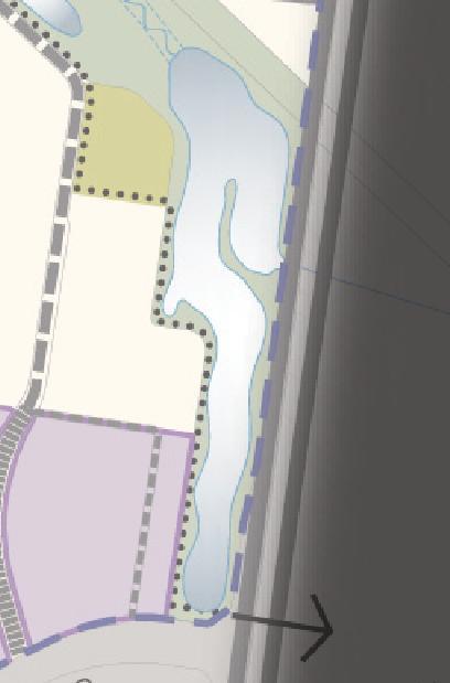
10 Table 2-2 Croskell PSP (PSP 5) Anticipated Development Yields PSP Population Households Enrolment Retail Jobs Non- Retail Jobs Croskell (PSP 5) Total Jobs 5,353 2, 2,34 2,725 5, The key features of the road network included in the draft Urban Structure are summarised as follows: > Three north-south Connector Streets that connect to Thompsons Road at the intersections with William Thwaites Boulevard and Wheelers Park Drive, and at the Cranbourne North Service Business Park. > A Connector Street Loop around the proposed commercial use area that fronts Thompsons Road. > An east-west Connector Street that connects the precinct to Berwick-Cranbourne Road to the south of Thompsons Road. > A number of internal local Access Streets. 2.4 Minta Farm (PSP ) Minta Farm PSP covers an area of approximately 285 hectares and is located to the north of Clyde North (PSP 3), to the west of Cardinia Creek and Officer South (PSP 5) and to the south of Officer (PSP 4). The PSP is generally bound by the Monash Freeway / Beaconsfield interchange to the north, Soldiers Rd to the west, Grices Rd to the south and Cardinia Creek to the east. The draft Urban Structure for the PSP is shown in Figure 2-4 (with an enlarged version included in Appendix A) Figure 2-4 Minta Farm PSP Draft Urban Structure As outlined in Figure 2-4, the draft Urban Structure includes residential, educational, and employment uses (various types). 3 August 25 Cardno
11 The anticipated development yields envisaged by the draft Urban Structure were provided by the MPA and are outlined in Table 2-3. Table 2-3 Minta Farm (PSP ) Anticipated Development Yields PSP Population Households Enrolment Retail Jobs Non- Retail Total Jobs Jobs Minta Farm (PSP ) 8,7 2,97 45,24 9,5,229 The key features of the road network included in the draft Urban Structure are summarised as follows: > A north-south Arterial Road through the precinct which will provide direct access to the Beaconsfield Interchange. This north-south Arterial will connect into Grices Road to the south of the Minta Farm PSP area (with the termination of Soldiers Road to the north) to create a four-way intersection. > The extension of O Shea Road along the northern precinct boundary to connect to the Beaconsfield Interchange. > A number of internal Connector Streets that connect the precinct to Soldiers Road. > A number of internal local Access Streets. 3 August 25 Cardno 7
12 3 Victorian Integrated Transport Model (VITM) 3. Victorian Integrated Transport Model (VITM) The Victorian Integrated Transport Model (VITM) has been used as the strategic modelling basis for this study. The VITM is a tool developed and maintained by the Department of Economic Development, Jobs, Transport and Resources (DEDJTR) to assist in the planning of road and public transport infrastructure in Victoria. It is a multimodal strategic model that uses future population, employment and land use data projections to forecast travel behaviour and the impacts of changes to the road and public transport networks. The VITM contains all major freeways, Arterial Roads and key Connector Streets within the Melbourne Statistical Division. The model is a link-based traffic model which is implemented in the CUBE Voyager software environment. 3.2 South East Growth Corridor VITM The MPA commissioned the refinement to the VITM for Melbourne s South East Growth Corridor. The purpose of this refinement was to provide a strategic model of the South East Growth Corridor which could be used to understand the transport needs of the MPA, City of Casey, Cardinia Shire Council and VicRoads for projects (such as PSPs) within the corridor. The refinements to VITM included the following: disaggregation of the zone system within the growth corridor; updates to the future modelled land use yields to reflect the level of growth predicted by the MPA within the corridor; updates to the road network within the corridor; and updates the centroid connectors. The latest version of this South East Growth Corridor model was obtained from the DEDJTR (VITM22_V2423_THOMPSONS_v2) on Dec 24 and used as the basis for this study. This version of the South East Growth Corridor VITM was recently updated by AECOM to assess the Thompsons Road (PSP 53), Clyde Creek (PSP 54) and Casey Fields South Residential (PSP 57.) PSPs, the details of which are outlined in the Thompsons Road, Clyde Creek and Casey Fields South (Residential) PSP 53, 54 & 57. Traffic Modelling report prepared by AECOM (Final Version, dated 25 July 24). 3.3 Model Limitations Strategic modelling is used to understand existing demands and travel patterns across a road network and assess how these change as a result of land use and transport infrastructure changes. The outputs of the modelling provide a guide to understanding the overall performance of a transport network. A key limitation is that VITM is a link based model which uses speed flow curves to calculate vehicle travel times as a function of the level of traffic. These functions are based on average observed behaviour on various road link types. In reality each section of road will have unique behavioural characterises which are largely determined by the operation of nearby intersections. VITM does not calculate different factors for different turning movements at an intersection or the impacts of queuing back and blocking back from one intersection to another. 3 August 25 Cardno 8
 and ultimate (24) years and recommended alterations to the models")
13 4 Model Review and Development 4. Preamble Cardno reviewed the VITM version VITM22_V2423_THOMPSONS_v2, referred to as the AECOM model hereafter, for the interim (22) and ultimate (24) years and recommended alterations to the models for the purposes of this study. In addition Cardno has now completed ultimate scenario modelling for the subject PSPs, the findings of which are outlined in the latter sections of this report. On agreement on the outcomes of the ultimate scenario modelling, Cardno will complete the interim scenario modelling. In this regard the following subsections also include the outcomes of Cardno s review and proposed changes to the 22 AECOM VITM. 4.2 PSPs as coded in AECOM VITM The draft Urban Structures for the subject PSPs within the context of the surrounding area are shown in Figure 4- and their locations within the AECOM are shown in Figure 4-2. Figure 4- PSP Localities 3 August 25 Cardno 9

14 Figure 4-2 PSP Locations in AECOM VITM 4.3 Road Networks Review 4.3. Overview Cardno reviewed and refined the AECOM VITM for the PSP areas and their surrounds. The extent of the areas reviewed and refined by Cardno are outlined in Figure August 25 Cardno

15 Figure 4-3 VITM Area Reviewed and Refined by Cardno Interim Road Network Review The interim road network included in the AECOM model is shown in Figure 4-4, whilst Figure 4-5 shows the changes proposed by Cardno for the purposes of this study. 3 August 25 Cardno


16 Figure 4-4 AECOM Interim (22) Scenario Road Network Coding Figure 4-5 Interim (22) Road Network Coding Changes Proposed by Cardno As shown in Figure 4-5, the changes proposed by Cardno generally involve refining the road network for the subject PSP areas to include the proposed Connector Streets. These Connector Streets within the PSP areas were coded with one lane in each direction, with a two-way capacity of 7, vehicles per day (vpd). 3 August 25 Cardno 2

17 The AECOM VITM posted speed limit plot and the changes made by Cardno are included in Appendix B. All Connector Streets within the subject PSPs with a posted speed limit of 5km/hr, with a further factor of. to be modelled to obtain the practical maximum speed on the road Ultimate Road Network Review The ultimate road network included in the AECOM model is shown in Figure 4-, with enlarged version of the plot included in Appendix B: Figure 4- AECOM Ultimate (24) Scenario Network Coding No further changes were undertaken by Cardno to the ultimate road network, other than those previously outlined for the interim scenario. 4.4 Zone System Review The zone system (interim and ultimate) included in the AECOM model is shown in Figure 4-7, whilst Figure 4-9 to Figure 4- show the changes made by Cardno for the purposes of this study. Enlarged versions of these plots, and plots showing the wider study area are included in Appendix E. The changes made by Cardno include disaggregation of existing zones and refinement to zone centroid connectors so that the centroid connectors connect to midblock sections of the local road network rather than at intersections to better represent real world traffic conditions. 3 August 25 Cardno 3

18 Figure 4-7 AECOM Zone System 3 August 25 Cardno 4
 to better reflect the draft Urban Structure of the PSP, the total number of zones however was not changed.")
19 Figure 4-8 Zone System Changes Proposed by Cardno McPherson (PSP 55) As shown in Figure 4-8, the refinements were made to the zone boundaries McPherson (PSP55) to better reflect the draft Urban Structure of the PSP, the total number of zones however was not changed. 3 August 25 Cardno 5
 from six zones to sixteen zones to better reflect the draft Urban Structure of the PSP.")
20 Figure 4-9 Zone System Changes Completed by Cardno Croskell (PSP 5) As shown in Figure 4-9, Cardno increased the number of zones within the Croskell (PSP 5) from six zones to sixteen zones to better reflect the draft Urban Structure of the PSP. 3 August 25 Cardno

21 Figure 4- Zone System Changes Proposed by Cardno Minta Farm (PSP ) As shown in Figure 4-, Cardno increased the number of zones within the Minta Farm PSP area from five zones to 9 zones to better reflect the draft Urban Structure of the PSP. 4.5 Modelled Land Uses The anticipated land uses for each of the subject PSPs, as provided by the MPA was previously outlined in Section 2, this data was used as input data into the Cardno VITM. A comparison of the Cardno VITM land use inputs and those included in the AECOM model is shown in Table 4-. More detail land uses included in the Cardno VITM are included in Appendix D. Table 4- Land Use Refinement Population House Hold Retail Jobs Total Jobs Enrolment AECOM Model McPherson PSP 2,89 9,7 28,78 2,85 Croskell PSP 5,797 2,4 3,4 43 Minta Farm PSP 4,823,82 442,59 Cardno Refinements McPherson PSP 35, 2,52 7,42 2,453 Croskell PSP 5,353 2, 2,34 5, Minta Farm PSP 8,7 2,97,24, August 25 Cardno 7
22 5 Ultimate Modelling Results 5. Introduction An assessment of the PSP transport demands and network performance has now been undertaken for the ultimate scenario. The outcomes from modelling are summarised in this section. 5.2 Review of VITM Traffic Generation In order to confirm that VITM was producing realistic levels of traffic generation for the subject PSP areas, the VITM generations were compared to a first principles assessment of the traffic generation for the PSP areas VITM Traffic Generation Table 5- below summarises the land use inputs and resulting traffic generation for the subject PSP area. Table 5- Ultimate Scenario VITM Trip Generation Summary (Year 24) PSP Residential (Households) Retail (Jobs) Land Use Non - Retail Employment (Jobs) School (Enrolments) AM - hr. Trips [] PM - hr. Trips [] Daily Vehicle Trips McPherson PSP 2, ,42 2,453 8,44,52,47 Croskell PSP 2, 2,34 2,725 5, - 2,958 4,494 45,33 Minta Farm PSP 2,97,24 9,5, ,232 5,45 54,74 [] - hour peak volumes were derived by applying a.55 factor to the VITM 2 hour peak outputs The results shown in Table 5- indicate that the daily VITM trip generation for the Croskell PSP is comparable to the level of the Minta Farm PSP, even though the Minta Farm PSP includes a notably higher level of total jobs. This difference is attributed to the retail area within in the Croskell PSP generating shopping trips throughout the day First Principles Generation Rates A summary of the modelled land uses and the resulting first principles traffic generation is provided in Table August 25 Cardno 8
23 Table 5-2 First Principles Traffic Generation - Ultimate Scenario (Year 24) PS P Land Use Yield Traffic Generation Rate Reduct ion AM PM Daily Factor (hr) (hr) for Interna l Trips Resultant Trips AM PM Daily (hr) (hr) Residential [] 2,52 dwellings.8 trips/househol d.8 trips/household. trips/househol d 25% [] 7,5 7,5 93,75 McPherson PSP Retail (jobs) [2] Other Employment (jobs) [3] 7 jobs.5 trips/ 3 jobs 375 jobs. trips / 5 jobs 4. trips / 3 jobs 5 trips / 3 jobs 2. trips / 5 jobs trips / 5 jobs 2% [4] 25% [4] , School [5] 2,453 students.75 trips/ student.25 trips/ student.5 trips/ student n/a,84 3 3,8 Total 9,4 9,45,9 Residential 2, dwellings.8 trips/househol d.8 trips/household. trips/househol d 25% [],297,297,28 Croskell PSP Retail (jobs) 2,34 jobs.5 trips/ 3 jobs Other Employment (jobs) 2,725 jobs. trips / 5 jobs 4. trips / 3 jobs 5 trips / 3 jobs 2. trips / 5 jobs trips / 5 jobs 2% [4] 25% [4] 93 2,872 3, ,88 School students.75 trips/ student.25 trips/ student.5 trips/ student n/a Total 2,42 4,98 5,58 Residential 2,97 dwellings.8 trips/househol d.8 trips/household. trips/househol d 25% [],782,782 22,275 Minta Farm PSP Retail (jobs),24 jobs.5 trips/ 3 jobs Other Employment (jobs) 9,5 jobs. trips / 5 jobs 4. trips / 3 jobs 5 trips / 3 jobs 2. trips / 5 jobs trips / 5 jobs 2% [4] 25% [4] 45,379 4,987,3 2,732 3,58 School 45 students.75 trips/ student.25 trips/ student.5 trips/ student n/a Total 3,93,5 5,59 ) Daily rate based on VISTA 9 data for the Casey LGA, peak hour rates are based on empirical data for comparable sites. A reduction factor of 25% has been applied to account for inter-zonal trips 2) Retail daily rate sourced from the RTANSW Guide to Traffic Generating Developments report (dated October 22) with PM peak hour rate assumed to be % of the daily rate. An AM rate of.5 trips/sqm has been adopted for service vehicle movements given that the LTC will not be fully operational during the AM peak hour. A rate of 3 jobs per sqm has been adopted for this assessment. 3) Office and commercial daily rate sourced from the RTANSW Guide to Traffic Generating Developments report (dated October 22) with PM peak hour rate assumed to be 2% of the daily rate. An AM rate equal PM has been adopted given that normal office/commercial should have movement same as PM peak hour. A rate of 5 jobs per sqm has been adopted for this assessment. 4) Based on Section 3.3 of the RTANSW Guide to Traffic Generating Developments report. It is assumed that 25% of all trips within the PSP will be internal to the zone given that the PSP includes a number of LTC s and schools. 5) Based on a first principles assessment 3 August 25 Cardno 9
24 It is highlighted that the first principles assessment outlined above takes into consideration the results of the Victorian Integrated Survey of Travel and Activity 29 (VISTA9) undertaken by the former Department Transport Planning and Local Infrastructure (DTPLI). VISTA9 is a comprehensive survey of how, when and why Victorians travel and is both more recent and location-specific than most other available empirical data sources. The average VISTA9 traffic generation rate of. movements per dwelling for the Casey LGA is higher than other empirical data sources which generally have a daily generation rate in the order of 7-9 vehicle movements per dwelling Comparison of VITM and First Principles Volume Analysis A comparison of VITM trip generation and first principles generation is provided in Table 5-3. This assessment compares the modelled traffic volume outputs from VITM to commonly used generation rates as means of confirming that VITM is generating realistic traffic demands. Table 5-3 VITM versus First Principles Assessment PSP Traffic Volumes AM Peak PM Peak Daily McPherson VITM 8,44,52,47 First Principle Assessment 9,4 9,45,9 % Difference 4% -4% 5% Croskell VITM 2,958 4,494 45,33 First Principle Assessment 2,42 4,98 5,58 % Difference -% % 4% Minta Farm VITM 4,232 5,45 54,74 First Principle Assessment 3,93,5 5,59 % Difference -7% % -% Table 5-3 indicates that the VITM road network demands are comparable (within 5%) to those of the first principles assessment for all of the subject PSPs, noting that some land use rates VITM is forecasting traffic demand to an appropriate level given the strategic nature of the model. 5.3 McPherson (PSP 55) The daily volume VITM plot for the McPherson (PSP 55) is outlined in Figure 5-, with the AM and PM peak outputs included in Appendix E (which also includes a wider-area daily output plot). 3 August 25 Cardno 2

25 Figure 5- Daily VITM Plot McPherson (PSP 55) Further discussion on the VITM daily volumes is provided in the following sub sections: 3 August 25 Cardno 2
26 5.3.2 North-south Volumes Figure 5- indicates that the proposed north-south Connector Street provisions within the PSP are generally sufficient, with the modelled daily volumes generally reflective of a Connector Street (i.e. in the order of 3, 7, vpd). It is however noted immediately to the south of Thompsons Road that the north-south Connector Street within the PSP is expected to carry some 7,vpd, and that to its west Smiths Lane is expected to carry some,7vpd. The volumes on the north-south Connector Street are higher than those on Smiths Lane as a result of it providing a more direct connection to Thompsons Road from the residential area in McPherson that is adjacent to Cardinia Creek. The volumes on this north-south Connector Street, although greater than the upper desirable limit for a Connector Street (i.e. 7,vpd) are still within the theoretical capacity of a twoway, two-lane road. Additional capacity could be provided on the north-south Connector Street or measures to increase the use of Smiths Lane over the north-south Connector Street (for example, turning or signal phasing restrictions at the intersection of the north-south Connector Street and Thompsons Road) could be implemented to manage and balance the expected north-south vehicle movements East-west Volumes Figure 5- indicates that the east-west Connector Streets within the PSP are generally expected to carry volumes reflective of a Connector Street (i.e. in the order of 3, 7, vpd). It is however noted that Figure 5- indicates that VITM predicts that the southern-most east-west Connector Street will carry in the order of,5vpd near Bells Road. It is however highlighted that the draft Urban Structure for the PSP includes an east-west Access Street to the north of Ballarto Road which is not included in VITM. This Access Street is expected to redistribute up to some 3,vpd away from the southern-most east-west Connector Street resulting in the daily volumes on this road generally being reflective of a Connector Street, noting that additional capacity will be needed at the intersection with Bells Road. Figure 5- also indicates that VITM predicts that the east-west Connector Street to the north of Patterson Road will carry some,vpd near Bells Road, and that Patterson Road will carry some, vpd near Bells Road. The distribution of more traffic to east-west Connector Street rather than Patterson Road is attributed to the strategic nature of VITM and the manner in which traffic exiting zones favours centroid connectors closer to their desired destination. In practice the volumes on Patterson Road are expected to be greater than those on the east-west Connector Street. The daily volumes on the east-west Connector Street are therefore expected to be reflective of a Connector Street (i.e. in the order of 7,vpd) given that the draft Urban Structure for the PSP also includes an east-west Access Street between the two roads which is not included in VITM. In addition Figure 5- indicates that the northern-most east-west Connector Street will carry in the order of,3vpd to the west of Smiths Lane as a result of vehicles gravitating towards the Bells Road Arterial Road. Whilst the daily volume is higher than the desirable upper limit for a Connector Street (7,vpd), the volumes are still within the theoretical capacity of a two-way, two-lane road and do not warrant the need for an Arterial Road connection. Austroads Standards Guide to Traffic Management Part 3 Traffic Studies and Analysis document which provides guidance on the daily traffic carrying capacity of urban roads. The daily capacity limits set out in this Austroads document are summarised as follows: Road Type Theoretical Daily Capacity (vehicles per day) 2-lane road 8, vpd 4-lane road 3, vpd - lane road 54, vpd 3 August 25 Cardno 22
 Figure 5-2 Daily VITM Plot Croskell (PSP 5) Figure 5-2 indicates that the proposed Connector Street network within the PSP is sufficient to cater for the anticipated traffic volumes.")
27 5.4 Croskell (PSP 5) The daily volume VITM plot for the Croskell (PSP 5) is outlined in Figure 5-2 with the AM and PM peak outputs included in Appendix G (which also includes a wider-area daily output plot) Figure 5-2 Daily VITM Plot Croskell (PSP 5) Figure 5-2 indicates that the proposed Connector Street network within the PSP is sufficient to cater for the anticipated traffic volumes. Additional capacity will however be required at the intersections of all three northsouth Connector Streets and Thompsons Road to cater for the anticipated traffic volumes. 3 August 25 Cardno 23
 Figure 5-3 Daily VITM Plot Minta Farm (PSP ) Figure 5-3, indicates that the proposed Arterial Road and Connector Street network within the PSP is sufficient cater for the anticipated")
28 5.5 Minta Farm (PSP ) The daily volume VITM plot for the Minta Farm (PSP ) is outlined in Figure 5-3, with the AM and PM peak outputs included in Appendix G (which also includes a wider-area daily output plot) Figure 5-3 Daily VITM Plot Minta Farm (PSP ) Figure 5-3, indicates that the proposed Arterial Road and Connector Street network within the PSP is sufficient cater for the anticipated traffic volumes. 3 August 25 Cardno 24
29 Summary and Conclusions. Summary Cardno has now completed ultimate scenario (24) modelling for the McPherson (PSP 55), Croskell (PSP 5) and Minta Farm (PSP ) precincts. Having refined the traffic model to reflect the expected land use and network scenarios, Cardno ran the model to provide 24 ultimate traffic volume outputs. The outputs of the VITM analysis were then compared to a first principles traffic generation demand assessment which showed that VITM was suitably forecasting traffic demand for the subject PSPs. A summary of the VITM assessments for each PSP is summarised as follows: McPherson (PSP 55) The east-west Connector Streets within the PSP are expected to carry volumes reflective of a Connector Street, with volumes expected to increase near the intersection with Smiths Lane indicating the need for additional capacity at the intersections. The north-south Connector Street provisions within the PSP are also generally sufficient. It is however noted immediately to the south of Thompsons Road that the north-south Connector Street within the PSP is expected to carry some 7,vpd and that to its west, Smiths Lane is expected to carry some,7vpd. The volumes on the north-south Connector Street are higher than those on Smiths Lane as a result of it providing a more direct connection to Thompsons Road from the residential area in McPherson that is adjacent to Cardinia Creek. The volumes on this north-south Connector Street, although greater than the upper desirable limit for a Connector Street (i.e. 7,vpd) are still within the theoretical capacity of a twoway, two-lane road. Additional capacity could be provided on the north-south Connector Street or measures to increase the use of Smiths Lane over the north-south Connector Street (for example, turning or traffic signal phasing restrictions at the intersection of the north-south Connector Street and Thompsons Road) could be implemented to manage and balance the expected north-south vehicle movements. Croskell (PSP 5) The proposed Connector Street network within the PSP is suffice for catering for the anticipated traffic volumes. Additional capacity will however be required at the intersections of all three north-south Connector Street and Thompsons Road to cater for the anticipated traffic volumes. Minta Farm (PSP ) The proposed Arterial Road and Connector Street network within the PSP is sufficient to cater for the anticipated traffic volumes..2 Conclusions Consultation on the ultimate scenario modelling outcomes with VicRoads and the City of Casey was undertaken in July 25. This process considered the need to complete the interim (22) modelling for the purpose of informing functional layout plans for the required intersections within the PSP areas. Given the current application of template intersections from the Growth Area Road Network Planning Guidance and Policy Principles it was agreed that interim modelling was no longer required. 3 August 25 Cardno 25
30 McPherson, Croskell and Minta Farm Precincts APPENDIX A DRAFT URBAN STRUCTURES October 25 Cardno 2
31


32
33
34 McPherson, Croskell and Minta Farm Precincts APPENDIX B VITM ULTIMATE ROAD NETWORK REVIEW October 25 Cardno 28
35 Victorian Integrated Transport Model - South East Growth Corridor Model 24 AECOM Model - Number of Lanes Hwy Port Western Rd Cranbourne Warren Narre Grices Rd Thompsons Rd Cardinia Rd Pattersons Rd Number of lanes each way: Lane 2 Lanes 3 Lanes Rail Line J:\VITM22_V2423_THOMPSONS_v2\ModelInputs\ Project Folder\CG447\Net\Thom_Inputs\24 Scenario 2\Y24_S2_AM_VITM_V32.NET 3/2/25 (Licensed to Cardno Victoria Pty Ltd)
36 Victorian Integrated Transport Model - South East Growth Corridor Model 24 Cardno Model - Number of Lanes Hwy Port Western Rd Cranbourne Warren Narre Clyde Rd Grices Rd Thompsons Rd Rd Berwick Hardys Rd Pound Rd Cardinia Rd Bells Rd Pattersons Rd Pattersons Rd Ballarto Rd J:\VITM22_V2423_THOMPSONS_v2\ModelInputs\ Project Folder\CG447\Net\24\Y24_S2_AM_VITM_V522.NET 25/2/25 Number of lanes each way: Lane 2 Lanes 3 Lanes Rail Line (Licensed to Cardno Victoria Pty Ltd)
37 Victorian Integrated Transport Model - South East Growth Corridor Model 24 AECOM Model - Posted Speed Limits J:\VITM22_V2423_THOMPSONS_v2\ModelInputs\ Project Folder\CG447\Net\Thom_Inputs\24 Scenario 2\Y24_S2_AM_VITM_V32.NET 23/2/25 Posted Speed: 2 km/hr 4 km/hr 5 km/hr km/hr 8 km/hr km/hr Rail Line (Licensed to Cardno Victoria Pty Ltd)
38 Victorian Integrated Transport Model - South East Growth Corridor Model 24 Cardno Model - Posted Speed Limits Rd Cranbourne Warren Narre Soldiers Rd Clyde Rd Grices Rd Grices Rd Thompsons Rd Thompsons Rd Rd Berwick Pound Rd Hardys Rd Cardinia Rd Bells Rd Pattersons Rd Tuckers Rd Pattersons Rd Bells Rd Ballarto Rd Posted Speed: 2 km/hr 4 km/hr 5 km/hr km/hr 8 km/hr km/hr Rail Line J:\VITM22_V2423_THOMPSONS_v2\ModelInputs\ Project Folder\CG447\Net\24\Y24_S2_AM_VITM_V522.NET 23/2/25 (Licensed to Cardno Victoria Pty Ltd)
39 McPherson, Croskell and Minta Farm Precincts APPENDIX C ZONE STRUCTURE REFINEMENTS October 25 Cardno 29
40 Victorian Integrated Transport Model - South East Growth Corridor Model AECOM Model Traffic Zone System (Licensed to Cardno Victoria Pty Ltd) 3/2/25 J:\VITM22_V2423_THOMPSONS_v2\ModelInputs\ Project Folder\CG447\Net\Thom_Inputs\24 Scenario 2\Y24_S2_AM_VITM_V32.NET Legend: Local Access/Connector Streets Secondary Arterial Primary Arterial Freeway Rail Line Zone Boundary Hwy Western Cranbourne Narre Thompsons Rd Cardinia Rd Pattersons Rd Port Rd Warren Grices Rd
41 Victorian Integrated Transport Model - South East Growth Corridor Model CARDNO Model Traffic Zone System Legend: Local Access/Connector Streets Secondary Arterial Primary Arterial Freeway Rail Line Zone Boundary O:\ENGTRAFF\Modelling\Strategic Transport Model\VITM22_V2423_THOMPSONS_v2\Base\CG447 SE PSP\Y24\HWY_WD_AFTERTRIPASSIGN_Y24.NET 22//25 (Licensed to Cardno Victoria Pty Ltd)
42 Victorian Integrated Transport Model - South East Growth Corridor Model CARDNO Model Traffic Zone System - PSP Clyde Rd Thompsons Rd Thompsons Rd Linsell Bvd Casey Fields Bvd Cranbourne Berwick Rd Legend: 2293 PSP Area Centroid Connector Local Access/Connector Street Secondary Arterial Primary Arterial Freeway Freeway J:\VITM22_V2423_THOMPSONS_v2\ModelInputs\ Project Folder\CG447\Net\24\Y24_S2_AM_VITM_V522.NET 23/2/25 (Licensed to Cardno Victoria Pty Ltd)
43 Victorian Integrated Transport Model - South East Growth Corridor Model CARDNO Model Traffic Zone System - PSP O'Shea Rd O'Shea Rd O'Shea Rd Soldiers Rd Grices Rd Grices Rd Legend: PSP Area 33 Centroid Connector Local Access/Connector Street Secondary Arterial Primary Arterial Freeway Freeway J:\VITM22_V2423_THOMPSONS_v2\ModelInputs\ Project Folder\CG447\Net\24\Y24_S2_AM_VITM_V522.NET 23/2/25 (Licensed to Cardno Victoria Pty Ltd)
44 McPherson, Croskell and Minta Farm Precincts APPENDIX D MODELLED LAND USES October 25 Cardno 3

45 Attachment B : Land Use Data PSP Minta Farm PSP Croskell PSP 5 McPherson PSP Zone Population Dwelling Employment Enrolment Population Dwelling Employment Enrolment Total , , Total , , Total N:\WINDOWS\24\CG447\Modelling\Land use\land USe FInal from MPA\547 Landuse data from MPA Cardno Merged all PSP.xlsm 3//25 Page
46 McPherson, Croskell and Minta Farm Precincts APPENDIX E 24 ULTIMATE OUTPUT VOLUMES October 25 Cardno 3
47 Victorian Integrated Transport Model - South East Growth Corridor Model 2 Hrs AM Total Volume Year 24 (Licensed to Cardno Victoria Pty Ltd) 3//25 O:\ENGTRAFF\Modelling\Strategic Transport Model\VITM22_V2423_THOMPSONS_v2\Base\CG447 SE PSP\Y24\HWY_AM_AFTERTRIPASSIGN_Base.CG447 SE PSP.Y24.NET Legend: Centroid Connector Local/Connector Road Highway/freeway Rail Way
48 Victorian Integrated Transport Model - South East Growth Corridor Model 2 Hrs AM Total Volume Year 24 McPherson PSP (Licensed to Cardno Victoria Pty Ltd) 3//25 O:\ENGTRAFF\Modelling\Strategic Transport Model\VITM22_V2423_THOMPSONS_v2\Base\CG447 SE PSP\Y24\HWY_AM_AFTERTRIPASSIGN_Base.CG447 Legend: Centroid Connector Local/Connector Road Highway/freeway Rail Way
Craigieburn Employment Precinct North and English Street
 Craigieburn Employment Precinct North and English Street METROPOLITAN PLANNING AUTHORITY Intersection Analyses 7 February 2014 Intersection Analyses Craigieburn Employment Precinct North and English Street
12 April Leakes Pty Ltd 211 Waverley Road EAST MALVERN VIC Attention: Joseph Nasr. Dear Joe,
 Our Ref: Contact: CG120569:VG Valentine Gnanakone Leakes Pty Ltd 211 Waverley Road EAST MALVERN VIC 3145 Attention: Joseph Nasr Dear Joe, 690 DERRIMUT ROAD PROPOSED RESIDENTIAL SUBDIVISION Further to our
Subarea Study. Manning Avenue (CSAH 15) Corridor Management and Safety Improvement Project. Final Version 1. Washington County.
 Corridor Management and Safety Improvement Project. Final Version 1. Washington County.") Subarea Study Manning Avenue (CSAH 15) Corridor Management and Safety Improvement Project Final Version 1 Washington County June 12, 214 SRF No. 138141 Table of Contents Introduction... 1 Forecast Methodology
Subarea Study Manning Avenue (CSAH 15) Corridor Management and Safety Improvement Project Final Version 1 Washington County June 12, 214 SRF No. 138141 Table of Contents Introduction... 1 Forecast Methodology
Colston Budd Rogers & Kafes Pty Ltd as Trustee for C & B Unit Trust ABN
 as Trustee for C & B Unit Trust ABN 27 623 918 759 Our Ref: 20 July, 2017 TR/10419/jj Transport Planning Traffic Studies Parking Studies Frasers Property Australia PO Box 4148 SHELLHARBOUR NSW 2529 Attention:
Alpine Highway to North County Boulevard Connector Study
 Alpine Highway to North County Boulevard Connector Study prepared by Avenue Consultants March 16, 2017 North County Boulevard Connector Study March 16, 2017 Table of Contents 1 Summary of Findings... 1
Attachment F: Transport assessment report on implications if Capell Avenue never formed
 Attachment F: Transport assessment report on implications if never formed CCL Ref: 14447-181118-williams.docx 18 November 2018 Tim Williams Williams and Co Limited By e-mail only: tim@williamsandco.nz
RELEASED UNDER THE OFFICIAL INFORMATION ACT 1982
 Subject MINISTERIAL BRIEFING NOTE Rapid Transit in Auckland Date 1 November 2017 Briefing number BRI-1133 Contact(s) for telephone discussion (if required) Name Position Direct line Cell phone 1 st contact
Tongaat Hullette Developments - Cornubia Phase 2. Technical Note 02 - N2/M41 AIMSUN Micro-simulation Analysis
 Technical Note 02 - N2/M41 AIMSUN Micro-simulation Tongaat Hullette Developments Cornubia Phase 2 Technical Note 02 - N2/M41 AIMSUN Micro-simulation Analysis Prepared by: 18/11/14 Justin Janki Date Approvals
Downtown Lee s Summit Parking Study
 Downtown Lee s Summit Parking Study As part of the Downtown Lee s Summit Master Plan, a downtown parking and traffic study was completed by TranSystems Corporation in November 2003. The parking analysis
54 Parkway Drive, Rosedale Proposed Residential / Commercial Development. Transportation Assessment Report. 30 April 2018
 54 Parkway Drive, Rosedale Proposed Residential / Commercial Development Transportation Assessment Report 30 April 2018 Project: Report title: Document reference: 54 Parkway Drive, Rosedale Transportation
TRAFFIC ENGINEERING ASSESSMENT MOUNT EDEN ROAD, MOUNT EDEN
 12 September 2017 Iain McManus Civitas Planning Consultants PO Box 47020 Ponsonby AUCKLAND 1144 Dear Iain, TRAFFIC ENGINEERING ASSESSMENT 43-45 45 MOUNT EDEN ROAD, MOUNT EDEN As requested, we have prepared
Craig Scheffler, P.E., PTOE HNTB North Carolina, P.C. HNTB Project File: Subject
 TECHNICAL MEMORANDUM To Kumar Neppalli Traffic Engineering Manager Town of Chapel Hill From Craig Scheffler, P.E., PTOE HNTB North Carolina, P.C. Cc HNTB Project File: 38435 Subject Obey Creek TIS 2022
Traffic Impact Assessment
 Shepparton North East Growth Area Precinct Structure Plan Appendix F Traffic Impact Assessment C:\Documents and Settings\jensenbr\Local Settings\Temporary Internet Files\Content.MSO\DF1103FA.tmp Revision
Interstate Operations Study: Fargo-Moorhead Metropolitan Area Simulation Output
 NDSU Dept #2880 PO Box 6050 Fargo, ND 58108-6050 Tel 701-231-8058 Fax 701-231-6265 www.ugpti.org www.atacenter.org Interstate Operations Study: Fargo-Moorhead Metropolitan Area 2015 Simulation Output Technical
CITY OF LONDON STRATEGIC MULTI-YEAR BUDGET ADDITIONAL INVESTMENTS BUSINESS CASE # 6
 2016 2019 CITY OF LONDON STRATEGIC MULTI-YEAR BUDGET ADDITIONAL INVESTMENTS BUSINESS CASE # 6 STRATEGIC AREA OF FOCUS: SUB-PRIORITY: STRATEGY: INITIATIVE: INITIATIVE LEAD(S): BUILDING A SUSTAINABLE CITY
PROPOSED BROILER FARMS
 PROPOSED BROILER FARMS BARINGHUP WEST Traffic Engineering Assessment Prepared for PAVILION PARTNERS MARCH, 2014 OUR REFERENCE: 16853R9457 PROPOSED BROILER FARMS BARINGHUP WEST Traffic Engineering Assessment
TRAFFIC IMPACT STUDY VICDOM BROCK ROAD PIT EXPANSION
 TRAFFIC IMPACT STUDY VICDOM BROCK ROAD PIT EXPANSION TOWNSHIP OF UXBRIDGE P/N 05-1993 June 2011 Revised -August 2011 Prepared by: Skelton, Brumwell & Associates Inc. 93 Bell Farm Road, Suite 107 Barrie,
Appendix B: Travel Demand Forecasts July 2017
 Appendix B: Travel Demand Forecasts July 2017 Table of Contents 1 Introduction... 2 2 Model Review and Updates... 2 2.1 Overview of Smart Moves Model ( City of London Model )... 2 2.1.1 Network and Zone
APPENDIX VMT Evaluation
 APPENDIX 2.7-2 VMT Evaluation MEMORANDUM To: From: Mr. Jonathan Frankel New Urban West, Incorporated Chris Mendiara LLG, Engineers Date: May 19, 2017 LLG Ref: 3-16-2614 Subject: Villages VMT Evaluation
Draft Marrickville Car Share Policy 2014
 Draft Marrickville Car Share Policy 2014 1. Background 1.1. Marrickville Council has supported car sharing in the LGA since 2007 as part of a holistic approach to encouraging more sustainable modes of
Travel Forecasting Methodology
 Travel Forecasting Methodology Introduction This technical memorandum documents the travel demand forecasting methodology used for the SH7 BRT Study. This memorandum includes discussion of the following:
Town of Londonderry, New Hampshire NH Route 28 Western Segment Traffic Impact Fee Methodology
 Town of Londonderry, New Hampshire NH Route 28 Western Segment Traffic Impact Fee Methodology Prepared by the Londonderry Community Development Department Planning & Economic Development Division Based
Transportation Statistical Data Development Report BAY COUNTY 2035 LONG RANGE TRANSPORTATION PLAN
 Transportation Statistical Data Development Report BAY COUNTY 2035 LONG RANGE TRANSPORTATION PLAN Prepared for Bay County Transportation Planning Organization and The Florida Department of Transportation,
Parks and Transportation System Development Charge Methodology
 City of Sandy Parks and Transportation System Development Charge Methodology March, 2016 Background In order to implement a City Council goal the City of Sandy engaged FCS Group in January of 2015 to update
Submission to Greater Cambridge City Deal
 What Transport for Cambridge? 2 1 Submission to Greater Cambridge City Deal By Professor Marcial Echenique OBE ScD RIBA RTPI and Jonathan Barker Introduction Cambridge Futures was founded in 1997 as a
To: File From: Adrian Soo, P. Eng. Markham, ON File: Date: August 18, 2015
 Memo To: From: Adrian Soo, P. Eng. Markham, ON : 165620021 Date: Reference: E.C. Row Expressway, Dominion Boulevard Interchange, Dougall Avenue Interchange, and Howard 1. Review of Interchange Geometry
Traffic Impact Statement (TIS)
") Traffic Impact Statement (TIS) Vincentian PUDA Collier County, FL 10/18/2013 Prepared for: Global Properties of Naples Prepared by: Trebilcock Consulting Solutions, PA 2614 Tamiami Trail N, Suite 615 1205
Traffic Impact Statement (TIS) Vincentian PUDA Collier County, FL 10/18/2013 Prepared for: Global Properties of Naples Prepared by: Trebilcock Consulting Solutions, PA 2614 Tamiami Trail N, Suite 615 1205
2.0 Development Driveways. Movin Out June 2017
 Movin Out June 2017 1.0 Introduction The proposed Movin Out development is a mixed use development in the northeast quadrant of the intersection of West Broadway and Fayette Avenue in the City of Madison.
1. INTRODUCTION 2. PROJECT DESCRIPTION CUBES SELF-STORAGE MILL CREEK TRIP GENERATION COMPARISON
 CUBES SELF-STORAGE MILL CREEK TRIP GENERATION COMPARISON 1. INTRODUCTION This report summarizes traffic impacts of the proposed CUBES Self-Storage Mill Creek project in comparison to the traffic currently
Cornubia Retail and Business Park Development
 Development July 2013 Tongaat Hulett Development (Pty) Ltd Tel. No.: 031 560 1900 Contact Person: Karen Petersen 21 West Riding Row, Sherwood Tel: 031 240 7300 Andrew McKune Andrew.McKune@smec.com SMEC
STRATEGIC PRIORITIES AND POLICY COMMITTEE MAY 5, 2016
 STRATEGIC PRIORITIES AND POLICY COMMITTEE MAY 5, 2016 Shift Rapid Transit Initiative Largest infrastructure project in the city s history. Rapid Transit initiative will transform London s public transit
TRANSPORTATION REVIEW
 TRANSPORTATION REVIEW - PROPOSED MIX OF LAND USES IS CONSISTENT WITH THE CITY S UNDER THE GRANVILLE BRIDGE POLICIES THAT AIM TO MEET NEIGHBOURING RESIDENTS SHOPPING NEEDS AND REDUCE RELIANCE ON AUTOMOBILE
RE: Taggart Retail Site Plan: Kanata West Proposal for Traffic Impact Study: Addendum #2
 1223 Michael Street, Suite 100, Ottawa, Ontario K1J 7T2 Tel: 613.738.4160 Fax: 613.739.7105 www.delcan.com July 9, 2014 OUR REF: TO3073TOK00 BY EMAIL: jparkes@taggart.ca/aturner@taggart.ca Taggart Commercial
committee report General Permitted Development Order SPT response to consultation
 committee report General Permitted Development Order SPT response to consultation Committee Strategy and Programmes Date of meeting 24 June 2011 Date of report 1 June 2011 Report by Assistant Chief Executive
TIMBERVINE TRANSPORTATION IMPACT STUDY FORT COLLINS, COLORADO JANUARY Prepared for:
 TIMBERVINE TRANSPORTATION IMPACT STUDY FORT COLLINS, COLORADO JANUARY 2014 Prepared for: Hartford Companies 1218 W. Ash Street Suite A Windsor, Co 80550 Prepared by: DELICH ASSOCIATES 2272 Glen Haven Drive
Travel Demand & Movement Patterns Report. Infrastructure Victoria FINAL REPORT
 Travel Demand & Movement Patterns Report Infrastructure Victoria FINAL REPORT 8 December 2017 Contents Summary 1 More Detailed Findings 9 Background and context 9 Growth in vehicle kilometres 14 Road utilisation
AECOM 30 Leek Cres., 4 th Floor Richmond Hill, ON L4B 4N4 Canada
 \ AECOM 30 Leek Cres., 4 th Floor Richmond Hill, ON L4B 4N4 Canada www.aecom.com 905-882-4401 tel 905-882-4399 fax Memorandum To CC Subject Peter Dorton (MTO), Eric Terro (MTO) Olga Garces (MTO) Page 1
Re: Addendum No. 4 Transportation Overview 146 Mountshannon Drive Ottawa, Ontario
 April 18 th, 2017 Mr. Kevin Yemm Vice President, Land Development Richraft Group of Companies 2280 St. Laurent Boulevard, Suite 201 Ottawa, Ontario (Tel: 613.739.7111 / e-mail: keviny@richcraft.com) Re:
Waco Rapid Transit Corridor (RTC) Feasibility Study
 Feasibility Study") Waco Rapid Transit Corridor (RTC) Feasibility Study Chris Evilia, Director of Waco Metropolitan Planning Organization Allen Hunter, General Manager Waco Transit System Jimi Mitchell, Project Manager AECOM
Waco Rapid Transit Corridor (RTC) Feasibility Study Chris Evilia, Director of Waco Metropolitan Planning Organization Allen Hunter, General Manager Waco Transit System Jimi Mitchell, Project Manager AECOM
TORONTO TRANSIT COMMISSION REPORT NO.
 Form Revised: February 2005 TORONTO TRANSIT COMMISSION REPORT NO. MEETING DATE: October 24, 2012 SUBJECT: DOWNTOWN RAPID TRANSIT EXPANSION STUDY (DRTES) PHASE 1 STRATEGIC PLAN ACTION ITEM RECOMMENDATIONS
Bi-County Transitway/ Bethesda Station Access Demand Analysis
 Bi-County Transitway/ Bethesda Station Access Demand Analysis Prepared for: Washington Metropolitan Area Transit Authority Office of Planning and Project Development May 2005 Prepared by: in conjunction
The Engineering Department recommends Council receive this report for information.
 CORPORATE REPORT NO: R161 COUNCIL DATE: July 23, 2018 REGULAR COUNCIL TO: Mayor & Council DATE: July 19, 2018 FROM: General Manager, Engineering FILE: 8740-01 SUBJECT: Surrey Long-Range Rapid Transit Vision
RE: Traffic Impact Statement: Paper Mill Lake Subdivision
 April 6 th, 2016 United Gulf Developments Limited 60 Walter Havill Dr, Suite 111 Halifax, Nova Scotia B3N 0A9 Attention: Navid Saberi RE: Traffic Impact Statement: Paper Mill Lake Subdivision DesignPoint
RE: A Traffic Impact Statement for a proposed development on Quinpool Road
 James J. Copeland, P.Eng. GRIFFIN transportation group inc. 30 Bonny View Drive Fall River, NS B2T 1R2 May 31, 2018 Ellen O Hara, P.Eng. Project Engineer DesignPoint Engineering & Surveying Ltd. 200 Waterfront
Environmental Assessment Derry Road and Argentia Road Intersection
 Air and Noise Study Environmental Assessment Derry Road and Argentia Road Intersection Project 11-4295 City of Mississauga, Region of Peel October 17, 2014 1 Region of Peel Environmental Assessment for
Proposed location of Camp Parkway Commerce Center. Vicinity map of Camp Parkway Commerce Center Southampton County, VA
 Proposed location of Camp Parkway Commerce Center Vicinity map of Camp Parkway Commerce Center Southampton County, VA Camp Parkway Commerce Center is a proposed distribution and industrial center to be
DRIVER SPEED COMPLIANCE WITHIN SCHOOL ZONES AND EFFECTS OF 40 PAINTED SPEED LIMIT ON DRIVER SPEED BEHAVIOURS Tony Radalj Main Roads Western Australia
 DRIVER SPEED COMPLIANCE WITHIN SCHOOL ZONES AND EFFECTS OF 4 PAINTED SPEED LIMIT ON DRIVER SPEED BEHAVIOURS Tony Radalj Main Roads Western Australia ABSTRACT Two speed surveys were conducted on nineteen
TRANSPORTATION IMPACT STUDY ALCONA SOUTH SECONDARY PLAN SLEEPING LION DEVELOPMENT TOWN OF INNISFIL
 TRANSPORTATION IMPACT STUDY ALCONA SOUTH SECONDARY PLAN SLEEPING LION DEVELOPMENT TOWN OF INNISFIL Prepared For: 1602850 Ontario Ltd. 2800 Highway 7 Vaughan, Ontario L4K 1W8 Prepared By: URS Canada Inc.
TRAFFIC IMPACT STUDY. USD #497 Warehouse and Bus Site
 TRAFFIC IMPACT STUDY for USD #497 Warehouse and Bus Site Prepared by: Jason Hoskinson, PE, PTOE BG Project No. 16-12L July 8, 216 145 Wakarusa Drive Lawrence, Kansas 6649 T: 785.749.4474 F: 785.749.734
2405 Mer Bleue Orleans, (Ottawa), ON Community Transportation Study Mattamy Homes. Prepared By: Stantec Consulting Ltd. Version 2
, ON Community Transportation Study Mattamy Homes. Prepared By: Stantec Consulting Ltd. Version 2") 2405 Mer Bleue Orleans, (Ottawa), ON Community Transportation Study Mattamy Homes Prepared By: Stantec Consulting Ltd. Version 2 April 2014 Stantec Consulting Ltd. 400-1331 Clyde Avenue, Ottawa ON K2C
2405 Mer Bleue Orleans, (Ottawa), ON Community Transportation Study Mattamy Homes Prepared By: Stantec Consulting Ltd. Version 2 April 2014 Stantec Consulting Ltd. 400-1331 Clyde Avenue, Ottawa ON K2C
Traffic and Toll Revenue Estimates
 The results of WSA s assessment of traffic and toll revenue characteristics of the proposed LBJ (MLs) are presented in this chapter. As discussed in Chapter 1, Alternatives 2 and 6 were selected as the
US 81 Bypass of Chickasha Environmental Assessment Public Meeting
 US 81 Bypass of Chickasha Environmental Assessment Public Meeting March 14, 2013 Introductions ODOT FHWA SAIC Meeting Purpose Present need for bypass Provide responses to 10/04/11 public meeting comments
Mercer Island Center for the Arts Parking Management Plan
 Parking Stalls Mercer Island Center for the Arts Parking Management Plan June 15, 2016 This Parking Management Plan (P) covers all tenants at the Mercer Island Center for the Arts (MICA) campus, including
For personal use only
 AER ISSUES NETWORK REVENUES DRAFT DECISIONS FOR ACT AND NSW ENERGY CUSTOMERS The Australian Energy Regulator (AER) has issued draft decisions on the revenue proposals submitted by ACT and NSW distribution
Executive Summary. Draft Environmental Impact Statement/Environmental Impact Report ES-1
 Executive Summary Introduction The Eastside Transit Corridor Phase 2 Project is a vital public transit infrastructure investment that would provide a transit connection to the existing Metro Gold Line
BERKELEY DOWNTOWN AREA PLAN PROGRAM ENVIRONMENTAL IMPACT REPORT TRAFFIC IMPACT ANALYSIS
 BERKELEY DOWNTOWN AREA PLAN PROGRAM ENVIRONMENTAL IMPACT REPORT TRAFFIC IMPACT ANALYSIS Prepared for: City of Berkeley Prepared by: REVISED JANUARY 9, 2009 Berkeley Downtown Area Plan Program EIR Traffic
MILLERSVILLE PARK TRAFFIC IMPACT ANALYSIS ANNE ARUNDEL COUNTY, MARYLAND
 MILLERSVILLE PARK TRAFFIC IMPACT ANALYSIS ANNE ARUNDEL COUNTY, MARYLAND Prepared for: Department of Public Works Anne Arundel County Prepared by: URS Corporation 4 North Park Drive, Suite 3 Hunt Valley,
Chairperson and Committee Members REGULATORY MANAGEMENT COMMITTEE 3 SEPTEMBER 2015
 Chairperson and Committee Members REGULATORY MANAGEMENT COMMITTEE 3 SEPTEMBER 2015 SPEED LIMIT CHANGE ON KĀPITI ROAD PURPOSE OF REPORT Meeting Status: Public Purpose of Report: For Decision 1 The purpose
2 MAJOR MACKENZIE DRIVE WEST JOG ELIMINATION AT HUNTINGTON ROAD CITY OF VAUGHAN
 2 MAJOR MACKENZIE DRIVE WEST JOG ELIMINATION AT HUNTINGTON ROAD CITY OF VAUGHAN The Transportation Services Committee recommends the adoption of the recommendations contained in the following report dated
The major roadways in the study area are State Route 166 and State Route 33, which are shown on Figure 1-1 and described below:
 3.5 TRAFFIC AND CIRCULATION 3.5.1 Existing Conditions 3.5.1.1 Street Network DRAFT ENVIRONMENTAL IMPACT REPORT The major roadways in the study area are State Route 166 and State Route 33, which are shown
CITY CLERK. Warrants for All-Way Stop Sign Control and 40 km/h Maximum Speed Limits
 CITY CLERK Clause embodied in Report No. 9 of the, as adopted by the Council of the City of Toronto at its Special Meeting held on July 30, 31 and August 1, 2002. 10 Warrants for All-Way Stop Sign Control
Proposed Supermarket Development Murradoc Road, Drysdale Expert Evidence
 Proposed Supermarket Development 24-32 Murradoc Road, Drysdale Expert Evidence Expert // Tim De Young Client // Coles Group Property Developments Limited Instructed by // Norton Rose Fulbright Reference
105 Toronto Street South, Markdale Transportation Impact Study. Paradigm Transportation Solutions Limited
 105 Toronto Street South, Markdale Transportation Impact Study Paradigm Transportation Solutions Limited December 2016 Project Summary Project Number 162060 December 2016 Client Zelinka Priamo Ltd 318
Resident Permit and Visitor Permit Guidelines
 OPERATING GUIDELINES Resident Permit and Visitor Permit Guidelines Approved by: GM, City Services May 2003 Subsequent Amendments: 9 September 2016 Associate Director (Vanessa Godden) Amended to reflect
Re: Sainte-Geneviève Elementary School (2198 Arch Street) Transportation Overview
 Transportation Overview") 2 March 2015 OUR REF: TO3205TOB00 Conseil des écoles catholiques du Centre-Est (CECCE) 4000 rue Labelle Ottawa, Ontario K1J 1A1 Attention: Maguy Eustache Dear Maguy: Re: Sainte-Geneviève Elementary School
2 March 2015 OUR REF: TO3205TOB00 Conseil des écoles catholiques du Centre-Est (CECCE) 4000 rue Labelle Ottawa, Ontario K1J 1A1 Attention: Maguy Eustache Dear Maguy: Re: Sainte-Geneviève Elementary School
Automated and Zero Emission Vehicle Infrastructure Advice
 Automated and Zero Emission Vehicle Infrastructure Advice 2046 Reference Scenario and AZEVIA Model Development FINAL REPORT Infrastructure Victoria 23 May 2018 Contents 1 Introduction 2 1.1 Background
Error! Reference source not found.
 shown in Error! Reference source not found..5. Four scenarios are shown representing the AM and PM peak periods for the current status quo of traffic and the 2011 projected traffic with all of the public
Parking Policy as a counter measure to promote public transport Case Study of Nehru Place, Delhi
 Parking Policy as a counter measure to promote public transport Case Study of Nehru Place, Delhi d Ravi Gadepalli Shakti Sustainable Energy Foundation Anusha Vaid itrans Pvt. Ltd. New Delhi, India India
DATE: March 21, 2017 REPORT NO. PW TYPE OF REPORT CONSENT ITEM [ ] ITEM FOR CONSIDERATION [ X ] 2.0 TOPIC
![DATE: March 21, 2017 REPORT NO. PW TYPE OF REPORT CONSENT ITEM [ ] ITEM FOR CONSIDERATION [ X ] 2.0 TOPIC](/thumbs/88/115267053.jpg "DATE: March 21, 2017 REPORT NO. PW TYPE OF REPORT CONSENT ITEM [ ] ITEM FOR CONSIDERATION [ X ] 2.0 TOPIC") PUBLIC WORKS COMMISSION PUBLIC WORKS COMMISSION DATE: March 21, 2017 REPORT NO. PW2017-022 TO: FROM: Chair and Members Committee of the Whole Operations and Administration E. (Beth) Goodger, General Manager
PUBLIC WORKS COMMISSION PUBLIC WORKS COMMISSION DATE: March 21, 2017 REPORT NO. PW2017-022 TO: FROM: Chair and Members Committee of the Whole Operations and Administration E. (Beth) Goodger, General Manager
Clyde Waste Transfer Facility Quarterly Truck Noise Measurements April 2009
 REPORT 10-6815-R3 Quarterly Truck Noise Measurements April 2009 PREPARED FOR Cnr Unwin & Shirley Street ROSEHILL NSW 2142 30 APRIL 2009 HEGGIES PTY LTD ABN 29 001 584 612 Quarterly Truck Noise Measurements
Table of Contents INTRODUCTION... 3 PROJECT STUDY AREA Figure 1 Vicinity Map Study Area... 4 EXISTING CONDITIONS... 5 TRAFFIC OPERATIONS...
 Crosshaven Drive Corridor Study City of Vestavia Hills, Alabama Table of Contents INTRODUCTION... 3 PROJECT STUDY AREA... 3 Figure 1 Vicinity Map Study Area... 4 EXISTING CONDITIONS... 5 TRAFFIC OPERATIONS...
Chevy Chase Lake. Preliminary Plan # B TRAFFIC STATEMENT. Prepared for: Chevy Chase Land Company & Bozzuto Development Company
 Chevy Chase Lake Preliminary Plan # 12002020B TRAFFIC STATEMENT Prepared for: Chevy Chase Land Company & Bozzuto Development Company Montgomery County, Maryland Prepared by: SSSTS Consulting (410) 718-8660
EXECUTIVE SUMMARY. The following is an outline of the traffic analysis performed by Hales Engineering for the traffic conditions of this project.
 EXECUTIVE SUMMARY This study addresses the traffic impacts associated with the proposed Shopko redevelopment located in Sugarhouse, Utah. The Shopko redevelopment project is located between 1300 East and
D. J. Halpenny & Associates Ltd. Consulting Transportation Engineers
 D. J. Halpenny & Associates Ltd. Consulting Transportation Engineers August 24, 2015 File: 115-622 Mr. R. Baumann, President The RGB Group 277 Kirchoffer Avenue Ottawa, ON K2A 1Y1 RE: RESIDENTIAL DEVELOPMENT
Point A Point B Point C Point D. Fulton County Board of Commissioners and Mayors Meeting December 14, 2017
 Fulton County Board of Commissioners and Mayors Meeting December 14, 2017 Master Plan Overview Phase 1 Community Vision and Existing Transit Conditions Phase 2 Scenario Development Phase 3 Transit Master
Interstate Operations Study: Fargo-Moorhead Metropolitan Area Simulation Results
 NDSU Dept #2880 PO Box 6050 Fargo, ND 58108-6050 Tel 701-231-8058 Fax 701-231-6265 www.ugpti.org www.atacenter.org Interstate Operations Study: Fargo-Moorhead Metropolitan Area 2025 Simulation Results
WP3 Transport and Mobility Analysis. D.3.8. Transport Scenarios Results Report Cesena
 WP3 Transport and Mobility Analysis D.3.8. Transport Scenarios Results Report Cesena May 2015 314164 (ENER/FP7/314164) Project acronym: InSMART Project full title: Integrative Smart City Planning Coordination
Parking Management Element
 Parking Management Element The State Transportation Planning Rule, adopted in 1991, requires that the Metropolitan Planning Organization (MPO) area implement, through its member jurisdictions, a parking
TRANSPORTATION MASTER PLAN AND TRANSPORTATION IMPACT ASSESSMENT FOR THREE SISTERS MOUNTAIN VILLAGE RESORT CENTRE ASP
 TRANSPORTATION MASTER PLAN AND TRANSPORTATION IMPACT ASSESSMENT FOR THREE SISTERS MOUNTAIN VILLAGE RESORT CENTRE ASP OCTOBER 2016 STANDARD LIMITATIONS This report was prepared by MMM Group Limited, a WSP
2030 Multimodal Transportation Study
 2030 Multimodal Transportation Study City of Jacksonville Planning and Development Department Prepared by Ghyabi & Associates April 29,2010 Introduction Presentation Components 1. Study Basis 2. Study
Traffic Impact Study Proposed Residential Development (Watson Parkway North - Starwood Drive Node, City of Guelph)
") Traffic Impact Study Proposed Residential Development (Watson Parkway North - Starwood Drive Node, City of Guelph) Prepared By: 332 Lorne Avenue East Stratford ON N5A 6S4 Prepared for: Paul Kemper, President
Traffic Impact Study Proposed Residential Development (Watson Parkway North - Starwood Drive Node, City of Guelph) Prepared By: 332 Lorne Avenue East Stratford ON N5A 6S4 Prepared for: Paul Kemper, President
Escondido Marriott Hotel and Mixed-Use Condominium Project TRAFFIC IMPACT ANALYSIS REPORT
 Escondido Marriott Hotel and Mixed-Use Condominium Project TRAFFIC IMPACT ANALYSIS REPORT Prepared for Phelps Program Management 420 Sixth Avenue, Greeley, CO 80632 Prepared by 5050 Avenida Encinas, Suite
GTA West Corridor Planning and EA Study Stage 1
 GTA West Corridor Planning and EA Study Stage 1 Draft Development Strategy Presentation to Peel Goods Movement Task Force April 8 2011 Study Areas 2 Unique Approach Unprecedented two-stage EA process:
TRAFFIC IMPACT ANALYSIS
 TRAFFIC IMPACT ANALYSIS Emerald Isle Commercial Development Prepared by SEPI Engineering & Construction Prepared for Ark Consulting Group, PLLC March 2016 I. Executive Summary A. Site Location The Emerald
Residential Development Bearna Engineering Services Report
 Residential Development Bearna Engineering Services Report APPENDIX D Job No: B861G TRAFFIC REPORT TRAFFIC IMPACT ASSESSMENT RESIDENTIAL DEVELOPMENT, BEARNA, CO. GALWAY Burkeway Homes Project No. B861
Energy Technical Memorandum
 Southeast Extension Project Lincoln Station to RidgeGate Parkway Prepared for: Federal Transit Administration Prepared by: Denver Regional Transportation District May 2014 Table of Contents Page No. Chapter
Proposed Dounreay - Mybster 275 kv / 132 kv
 Background Scottish Hydro-Electric Transmission Ltd (SHETL) is proposing a new 275 kilovolt (kv) (1 kilovolt = 1000volts) double circuit overhead line (OHL) between the Dounreay sub station and the new
TABLE OF CONTENTS EXECUTIVE SUMMARY...1 INTRODUCTION...3 PROJECTED FUTURE GROWTH...3 ROADWAY IMPROVEMENT PROJECTS...4 POTENTIAL FUNDING SOURCES...
 Transportation Impact Fee Study September 2014 TABLE OF CONTENTS EXECUTIVE SUMMARY...1 INTRODUCTION...3 PROJECTED FUTURE GROWTH...3 ROADWAY IMPROVEMENT PROJECTS......4 POTENTIAL FUNDING SOURCES...7 PROPOSED
West Broadway Transit Study. Community Advisory Committee September 17, 2015
 West Broadway Transit Study Community Advisory Committee September 17, 2015 Introductions Community Engagement Summer Outreach Fall Outreach Technical Analysis Process Update Alternatives Review Economic
Project : A Prepared by: Jack Wellings / Andrew Hughes. Client: Wembdon Parish Council Approved by: Philip Weatherhead
 Technical Note 01 Project: Wembdon Neighbourhood Plan Office: Wellington Project : A108388 Prepared by: Jack Wellings / Andrew Hughes Client: Wembdon Parish Council Approved by: Philip Weatherhead Date:
West Hills Shopping Centre Lowe s Expansion Traffic Impact Study
 West Hills Shopping Centre Lowe s Expansion Traffic Impact Study Prepared for: Armel Corporation January 2015 Paradigm Transportation Solutions Ltd. 22 King Street South, Suite 300 Waterloo ON N2J 1N8
Continued coordination and facilitation with City of Austin staff on documentation of processes to permit construction activities at the site.
 Project Manager Ed Collins LJA Engineering, Inc. Transportation Planning Manager 5316 Highway 290 West Austin Public Infrastructure Group Austin, TX 78735 (512) 762-6301 cell (512) 439-4757 office CARTS
APPENDIX C-2. Traffic Study Supplemental Analysis Memo
 APPENDIX C-2 Traffic Study Supplemental Analysis Memo The Mobility Group Transportation Strategies & Solutions Memorandum To: From: Subject: Tomas Carranza, LADOT Matthew Simons Traffic Review - Revised
Attachment 5 Eglinton West LRT Planning and Technical Update
 Eglinton West LRT Planning and Technical Update 1. Introduction In July 2016, City Council approved an Eglinton West LRT with between 8 and 12 stops between Mount Dennis and Renforth Gateway, and up to
PART TRANSPORT AND TRAFFIC. > Traffic Impact Assessment prepared by Cardno
 PART 8 TRANSPORT AND TRAFFIC > Traffic Impact Assessment prepared by Cardno TRAFFIC IMPACT ASSESSMENT PREPARED BY CARDNO 750890 750890 Prepared for Adani Mining Pty Ltd October 2012 Document Information
The Eastern Connector Study November, 2007 planning for the future
 The Eastern Connector Study November, 2007 planning for the future In late 2006, Albemarle County and the City of Charlottesville jointly initiated the Eastern Connector Corridor Study. The Project Team
WAITING FOR THE GREEN LIGHT: Sustainable Transport Solutions for Local Government
 WAITING FOR THE GREEN LIGHT: Sustainable Transport Solutions for Local Government C Published by the Climate Council of Australia Limited Climate Council of Australia Ltd 2018 ISBN-13: 978-1-925573-70-1
2030 Comprehensive Plan Goals, Objectives, and Policies Mobility Working Document
 TRANSPORTATION ELEMENT 2030 Comprehensive Plan Goals, Objectives, and Policies Mobility Working Document GOAL 1 The City shall utilize Quality/Level of Service standards which meet the Florida Department
V03. APTA Multimodal Operations Planning Workshop August Green Line LRT
 V03 APTA Multimodal Operations Planning Workshop August 2016 Green Line LRT 2 Presentation Outline Past Present Future 3 16/03/2016 RouteAhead Update 4 4 16/03/2016 RouteAhead Update 5 5 16/03/2016 6 6
Application of EMME3 and Transportation Tomorrow Survey (TTS) for Estimation of Zonal Time Varying Population Density Distribution in
 for Estimation of Zonal Time Varying Population Density Distribution in") Application of EMME3 and Transportation Tomorrow Survey (TTS) for Estimation of Zonal Time Varying Population Density Distribution in the Greater Toronto Area Prepared by: Matthew Roorda, Associate Professor
Application of EMME3 and Transportation Tomorrow Survey (TTS) for Estimation of Zonal Time Varying Population Density Distribution in the Greater Toronto Area Prepared by: Matthew Roorda, Associate Professor