Arizona-Sonora Border Master Plan. Plan Maestro para la Frontera Arizona-Sonora
|
|
|
- Elvin Higgins
- 5 years ago
- Views:
Transcription
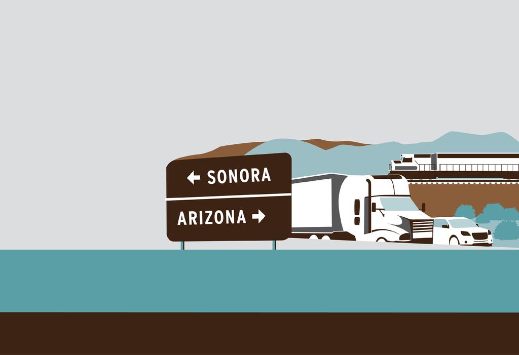


1 Arizona-Sonora Border Master Plan Plan Maestro para la Frontera Arizona-Sonora

2 Project Objectives Develop and implement a plan for identifying, prioritizing, and promoting land port of entry (LPOE), multi-modal infrastructure and rail projects. Design a process to ensure that relevant stakeholder agencies participate in the planning of LPOE projects and related transportation infrastructure improvements. San Luis 1 POE

3 Project Objectives Increase the understanding of the LPOE and transportation planning processes on both sides of the border. Establish a process for continued dialogue among federal, state, regional, and local stakeholder agencies in Arizona and Mexico that will promote coordination on current and future projects. Lukeville POE
 Senior agency technical staff")
4 Committees Policy Advisory Committee (PAC) Executive-level agency managers Technical Working Group (TWG) Senior agency technical staff DeConcini POE

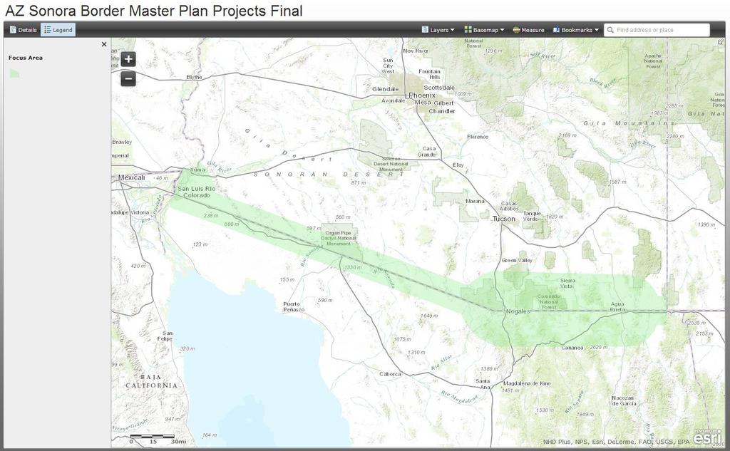
5 Focus Study Area
6 Committee Meetings PAC only Meetings 4 TWG only Meetings 4 Combined PAC/TWG Meetings 3 Bi-national effort Hermosillo Meetings 2 Mexico City Meetings 1 PAC/TWG Meetings - Simultaneous Translation


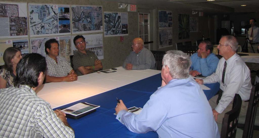
7 Stakeholder Meetings Bi-national effort Stakeholder Meetings Stakeholder Outreach Plan


8 Stakeholder Meetings Bi-national effort Stakeholder Meetings


9 Stakeholder Meetings Bi-national effort Stakeholder Meetings
10 Border Master Plan Chapters 1-4: Existing Conditions/ Study Area Chapters 5-6: Land Ports of Entry Chapter 7: Future Conditions Chapter 8: Project Evaluations Chapter 9: Funding Chapter 10: Implementation Chapter 11: Long-term Planning Considerations Chapter 12: Stakeholder Involvement 10 San Luis 2 POE

11 Evaluation Criteria Types of Projects LPOE s Multi-modal Infrastructure: Roadway/Bridge/Interchange/ Pedestrian/Bicyclist/Transit Rail Naco POE
 Regional Benefit Bi-national Coordination (LPOEs only) Douglas")
12 Evaluation Criteria Confirmed Categories of Evaluation Criteria by Project Type Cost Effectiveness Project Readiness Capacity/Congestion LPOE Connectivity (n/a for LPOEs) Regional Benefit Bi-national Coordination (LPOEs only) Douglas POE

13 Evaluation Criteria Arizona-Sonora Border Master Plan Category Prioritization Results LPOE MMI Rail Capacity/Congestion 40% 36% 35% Cost Effectiveness 15% 15% 16% Regional Benefit 21% 23% 21% Project Readiness 11% 10% 13% LPOE Connectivity n/a 16% 15% Bi-national Coordination 13% n/a n/a San Luis 2 POE
14 Final Project Rankings LPOEs By State Combined Multimodal Infrastructure Rail
15 Arizona LPOE Project Rankings Evaluation of Arizona Land Port of Entry Projects Capacity/Congestion Project Cost (in $1,000s) Cost Effectiveness Regional Benefit Project Readiness Binational Coord. Weighted Combined Score Arizona LPOE Overall Rank Max Point Value Out of 17 ID Zone State Linked Proj LPOE Project Description AZ San Luis I - SENTRI Primary Booth Project AZ San Luis I - Pedestrian Pop-Out Project #1 (Reconfiguration in place) AZ San Luis I - Pedestrian Pop-Out Project #2 (Expansion) 15 1, AZ 5, 3012, 4001 San Luis II - POV / Pedestrian Processing Facility 24 25, AZ 102, 3010 Douglas - Expansion and Modernization 23 90, AZ San Luis I - SENTRI Secondary Inspection Area AZ San Luis I - Outbound Technology Project AZ 3009 Douglas - Non-Commerical Port Reconfiguration 17 80, AZ San Luis I - Primary Booth Replacement Project AZ 3003 San Luis I - Expansion and Modernization 21 80, AZ 3003 San Luis I - Outbound Inspection Infrastructure AZ 108, 2005, Nogales Area (east) - New LPOE , AZ DeConcini - Repatriation Consolidation 9 1, AZ 2006, 3007 Nogales Area (west) - New Rail LPOE 8 5, AZ 102, 1016, 3008 Douglas - New Commercial Port Facility 10 35, AZ 2001, 3002 San Luis II - New Rail LPOE 5 5, AZ 2008, 3011 Naco - New Rail LPOE 5 5,
16 Sonora LPOE Project Rankings ID Zone State SON Linked Project Evaluation of Sonora Land Port of Entry Projects LPOE Project Description 1007, 1008, San Luis Rio Colorado I , 4004, Expansion and 4005 Modernization Proposed Improvement Reconstruction of the LPOE to improve southbound processing of passenger vehicles and pedestrians. Capacity/Congestion Project Cost (in $1,000s) Cost Effectiveness Regional Benefit Project Readiness Binational Coord. Max Point Value Weighted Combined Score 100 Sonoran LPOE Overall Rank Out of , SON SON 5, 1004, SON SON SON SON 1016, 1017, 3008 San Luis II - POV/Ped Processing Nogales III (adjacent to Mariposa LPOE)- Expansion and Modernization Agua Prieta - Expansion and Modernization Sonoyta - Expansion and Modernization Agua Prieta - Non- Commercial Port Reconfiguration Nogales III - New Customs Processing Facility for Commercial Vehicles Expansion of the existing San Luis Rio Colorado II commercial LPOE to accommodate passenger vehicles and pedestrians. Reconfiguration of the existing LPOE facility immediately adjacent to the border to improve southbound processing of passenger vehicles and pedestrians. Reconstruction of the LPOE to improve southbound processing of commercial vehicles, passenger vehicles, and pedestrians. Would negate the need for projects 3008 and Reconstruction of the LPOE to improve southbound processing of commercial vehicles, passenger vehicles, and pedestrians. Also includes additional queuing capacity for northbound traffic to coincide with improvements at Lukeville, AZ. Reconfiguration of the existing LPOE. Assumes relocation of commercial vehicle processing to a new commercial port (Project ID 3008). Construction of a new LPOE facility 1.25 miles south of the border to improve northbound and southbound processing of primarily Maquiladora industry commercial vehicles , , , , ,
17 Combined LPOE Project Rankings Arizona LPOE Projects Sonoran LPOE Projects Zone ID LPOE Project Description Project Score* ID LPOE Project Description Project Score* Combined Project Score 2 n/a Completed Project - Expansion and Modernization of Mariposa LPOE Nogales III (adjacent to Mariposa LPOE)- Expansion and Modernization n/a 2 n/a Completed Project - Expansion and Modernization of Lukeville LPOE Completed Project - Expansion and Modernization of Mariposa LPOE Sonoyta - Expansion and Modernization Nogales III - New Customs Processing Facility for Commercial Vehicles San Luis II - POV / Pedestrian Processing Facility San Luis II - POV/Pedestrian Processing San Luis I - Expansion and Modernization Douglas - Expansion and Modernization Douglas - Non-Commercial Port Reconfiguration San Luis Rio Colorado I - Expansion and Modernization Agua Prieta - Expansion and Modernization Agua Prieta - Non-Commercial Port Reconfiguration Nogales Area (east) - New LPOE Nogales Area (east) - New LPOE Douglas - New Commercial Port Facility Agua Prieta - New Commercial Port Facility(*) Nogales Area (west) - New Rail LPOE Nogales Area (west) - New Rail LPOE San Luis II - New Rail LPOE San Luis Rio Colorado II - New Rail LPOE Naco - New Rail LPOE Naco - New Rail LPOE 26 51
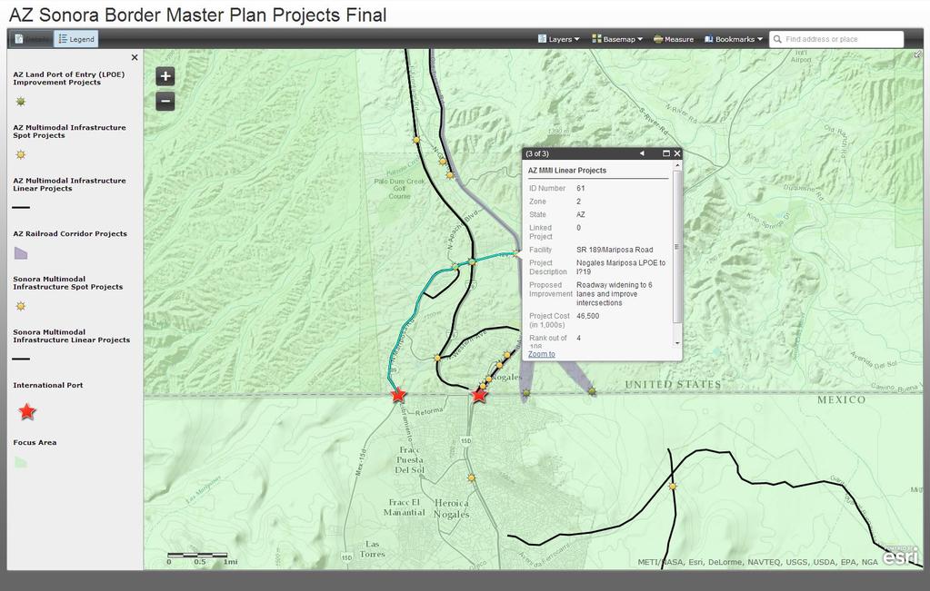
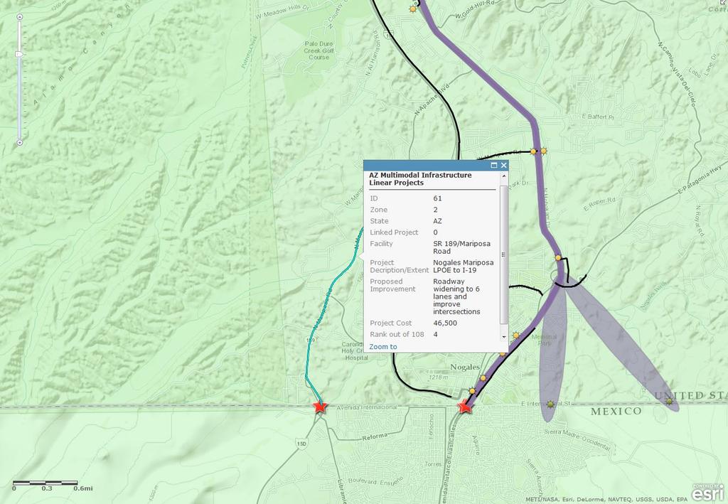
18 Arizona MMI Project Rankings Evaluation of Arizona Multimodal Infrastructure Projects Max Point Value Out of 108 ID Zone State Linked Project Facility Project Description/Extent Proposed Improvement 1 1 AZ Archibald Street and First Convert to One-Way Couplet & C Street to Urtuzuastegui Street Avenue construct bus pulllouts AZ Main Street Project Hwy 95 from A St to Juan Sanchez Blvd Design & Construction AZ I-19 Interchanges At SR 289/Ruby Road Interchange Upgrades: Round-a-bout AZ 66,67,69, SR 189/Mariposa Road Nogales Mariposa LPOE to I-19 73, AZ 4 Juan Sanchez Blvd 10 th Avenue to Avenue E Roadway widening to 6 lanes and improve intercsections Widen to 5 lanes, Unspecified Improvements Capacity/Congestion Project Cost (in $1,000s) Cost of Project vs. Projected Demand Regional Benefit Project Readiness LPOE Connectivity Weighted Combined Score Arizona MMI Overall Rank AZ Pedestrian Staging Area On Arizona Side of international border near Mariposa LPOE (SR Construct new facility just north of border) 4 1 AZ 3 Juan Sanchez Boulevard 10 th Avenue to US-95 Widening, Unspecified Improvements AZ 64,68,84 Crawford Street At UPRR - Nogales Pedestrian Overpass AZ Chino Road Realignment Douglas Realign at intersection of SR 80 and US-191 and update to ADOT standards AZ 63,68,84 New Pedestrian Bridge South of Court Street Construct new pedestrian bridge across the railroad AZ Ruby Road At UPRR Vehicular Overpass AZ 61,67,69, Design and Reconstruct to 6-lane SR 189 / Mariposa Road Grand Avenue to I-19 73,76 roadway AZ 1017, 3008 Chino Road Extension Project Extension Project in City of Douglas Extension Project in City of Douglas
19 Sonora MMI Project Rankings ID Zone State SON Evaluation of Sonora Multimodal Infrastructure Projects 5, 1004, 3012, SON SON SON SON SON SON Max Point Value Linked Projects Facility Project Description/Extent Proposed Improvement Bypass closely spaced signals Upgrade, shoulder & safety in urbanized area of Mexico improvements to 7 miles of existing Federal Highway 2 to 6 1, , 4003, 4005 San Luis Rio Colorado Loop Phase I Mexico Federal Route 8 Saric Sasabe Highway Altar-Sasabe Highway Mexico Federal Route 2 Nogales-Santa Cruz Highway San Luis Rio Colorado - First Street accommodate a more efficient movement of trucks Sonoyta LPOE to Mexico Federal Route 2 Construct improved connection between Saric and Sasabe, Sonora Construct improved connection between Altar and Sasabe, Sonora Mexico Federal Route 2 Juarez-Cananea netween Cananea-Agua Prieta Construct improved connection between Nogales and Santa Cruz, Sonora LPOE to Madero Street two lane roadway to Type A2 per SCT standards Upgrade 2 miles of existing roadway and construct four reversible through lanes and two lanes for local access Construct 31 miles of two lane roadway to Type C per SCT standards, including 12 bridges Construct 50 miles of two lane roadway to Type C per SCT standards Upgrade 47 miles of existing two lane roadway and construct two additional lanes to Type A2 per SCT standards Construct 35 miles of two lane roadway to Type C per SCT standards Conversion to pedestrian/ bicycle facility only and construction of alternative mode overpass crossing Obregon Avenue (Mexico Federal Route 2) Capacity/Congestion Project Cost (in $1,000s) Cost of Project vs. Projected Demand Regional Benefit Project Readiness LPOE Connectivity Weighted Combined Score 19 Sonora MMI Overall Ranking Out of , , , , ,
20 RAIL Evaluation of Arizona Rail Projects Approximate project length (miles)* Capacity/Congestion Estimated Project Cost Cost Effectiveness Regional Benefit Project Readiness LPOE Connectivity Weighted Combined Score Arizona Rail Overall Ranking ID Zone State Linked Project Rail Project Description Max Point Value Out of AZ Build second line (track)/nogales Branch (MP 65 to border) 65 9 $3-7m/mi AZ Upgrade Nogales Branch (to accommodate heavier vehicles) 65 6 $3-7m/mi AZ AZ AZ 1011, 3006 New rail corridor/puerta de Anza (east side of Nogales) Under 10 8 $15m/mi , 3007 New rail corridor/west side of Nogales Under 10 8 $15m/mi , 3002 New rail corridor/through San Luis II LPOE $15m/mi AZ 1014, 3011 Rehab and new rail/benson or Curtiss to Naco LPOE $15m/mi AZ Passenger rail service/nogales to Tucson $15m/mi AZ Rehab and new rail/gila Bend to Lukeville LPOE $15m/mi Comments: Rail corridors are conceptual. Projects 1011 and 1013 (Nogales bypasses) are assumed to be additional corridors, not a replacement for the existing rail line. Projects 2003 & 2004 are planned UPRR (Private Investment) Projects
21 Results Prioritized List of Projects The Program Recognizes Funding Realities References Statewide Framework Strategies Federal Approach: Low Cost / High Impact Project Linkages and Inter-Relationships LPOE MMI Rail
22 Recommendations Comprehensive Wait Time Study at each of the LPOEs Travel Demand Modeling (TDM) from SCT Border Area Focused TDM integrate ADOT and SCT models
23 Recommendations Implementation Monitoring Committee (Concept) Chairperson / Champion Performance Assessment Report Card Quarterly Updates Reporting to the AMC, JWC and TTCA Federal/State Programming Coordination GSA, DOS, CBP, FHWA, ADOT INDAABIN, SRE, ADUANAS, SCT, SIDUR
24 Recommendations GIS Tool 24
25 Recommendations GIS Tool 25

26 Final BMP Website 26 Sasabe POE
SOUTHERN GATEWAY. Transportation and Trinity River Project Committee 11 May 2015
 SOUTHERN GATEWAY Transportation and Trinity River Project Committee 11 May 2015 Southern Gateway Project History Began in 2001 as a Major Investment Study [ MIS ], Schematic, and Environmental Assessment
Waco Rapid Transit Corridor (RTC) Feasibility Study
 Feasibility Study") Waco Rapid Transit Corridor (RTC) Feasibility Study Chris Evilia, Director of Waco Metropolitan Planning Organization Allen Hunter, General Manager Waco Transit System Jimi Mitchell, Project Manager AECOM
Waco Rapid Transit Corridor (RTC) Feasibility Study Chris Evilia, Director of Waco Metropolitan Planning Organization Allen Hunter, General Manager Waco Transit System Jimi Mitchell, Project Manager AECOM
The Eastern Connector Study November, 2007 planning for the future
 The Eastern Connector Study November, 2007 planning for the future In late 2006, Albemarle County and the City of Charlottesville jointly initiated the Eastern Connector Corridor Study. The Project Team
STH 60 Northern Reliever Route Feasibility Study Report
 #233087 v3 STH 60 Northern Reliever Route Feasibility Study Report Washington County Public Works Committee Meeting September 28, 2016 1 STH 60 Northern Reliever Route Feasibility Study Hartford Area Development
IMPROVEMENT CONCEPTS
 IMPROVEMENT CONCEPTS for the South Novato Transit Hub Study Prepared by: January 11, 2010 DKS Associates With Wilbur Smith Associates IMPROVEMENT CONCEPTS Chapter 1: Introduction 1. INTRODUCTION The strategic
BROWARD BOULEVARD CORRIDOR TRANSIT STUDY
 BROWARD BOULEVARD CORRIDOR TRANSIT STUDY FM # 42802411201 EXECUTIVE SUMMARY July 2012 GOBROWARD Broward Boulevard Corridor Transit Study FM # 42802411201 Executive Summary Prepared For: Ms. Khalilah Ffrench,
Chapter 7: Corridor Visions
 Chapter 7: Corridor Visions (see also Appendix 7 for Details) January 24, 2008 NOTE: This document has been prepared using Federal funding from the United States Department of Transportation. The United
Harlem Avenue between 63 rd and 65 th
 Harlem Avenue between 63 rd and 65 th Community Advisory Group Meeting #3 December 1, 2017 Bedford Park Public Library 1 Meeting Agenda 1. Welcome/Introductions (3 mins) 2. Project Overview and Re-Cap
King County Metro. Columbia Street Transit Priority Improvements Alternative Analysis. Downtown Southend Transit Study. May 2014.
 King County Metro Columbia Street Transit Priority Improvements Alternative Analysis Downtown Southend Transit Study May 2014 Parametrix Table of Contents Introduction... 1 Methodology... 1 Study Area...
Final Series of Public Meetings
 Final Series of Public Meetings Public Meeting Locations City Date Jasper Monday, September 26 Livingston Tuesday, September 27 Huntsville Wednesday, September 28 Bryan Thursday, September 29 Eldorado
METRO Orange Line BRT American Boulevard Station Options
 METRO Orange Line BRT American Boulevard Station Options Bloomington City Council Work Session November 18, 2013 Christina Morrison BRT/Small Starts Project Office Coordinating Planning and Design AMERICAN
Develop ground transportation improvements to make the Airport a multi-modal regional
 Project Overview TRANSPORTATION IMPROVEMENTS WHAT ARE THE PROJECT GOALS? Transportation transportation hub. Develop ground transportation improvements to make the Airport a multi-modal regional Land Use
5. OPPORTUNITIES AND NEXT STEPS
 5. OPPORTUNITIES AND NEXT STEPS When the METRO Green Line LRT begins operating in mid-2014, a strong emphasis will be placed on providing frequent connecting bus service with Green Line trains. Bus hours
Restoration of Historic Streetcar Services in Downtown Los Angeles
 Restoration of Historic Streetcar Services in Downtown Los Angeles Early Scoping Meeting for Alternatives Analysis (AA) May 17, 2011 Introduction Key players Local lead agency: Metro Federal lead agency:
I-820 (East) Project Description. Fort Worth District. Reconstruct Southern I-820/SH 121 Interchange
 Project Description. Fort Worth District. Reconstruct Southern I-820/SH 121 Interchange") I-820 (East) Project Description Fort Worth District Reconstruct Southern I-820/SH 121 Interchange I-820 from approximately 2,000 feet north of Pipeline Road/Glenview Drive to approximately 3,200 feet
I-820 (East) Project Description Fort Worth District Reconstruct Southern I-820/SH 121 Interchange I-820 from approximately 2,000 feet north of Pipeline Road/Glenview Drive to approximately 3,200 feet
Kendall Drive Premium Transit PD&E Study Project Kick-Off Meeting SR 94/Kendall Drive/SW 88 Street Project Development and Environment (PD&E) Study
 Study") Florida Department of Transportation District Six Kendall Drive Premium Transit PD&E Study Project Kick-Off Meeting SR 94/Kendall Drive/SW 88 Street Project Development and Environment (PD&E) Study What
Florida Department of Transportation District Six Kendall Drive Premium Transit PD&E Study Project Kick-Off Meeting SR 94/Kendall Drive/SW 88 Street Project Development and Environment (PD&E) Study What
Energy Technical Memorandum
 Southeast Extension Project Lincoln Station to RidgeGate Parkway Prepared for: Federal Transit Administration Prepared by: Denver Regional Transportation District May 2014 Table of Contents Page No. Chapter
PUBLIC INFRASTRUCTURE PROJECTS
 PUBLIC INFRASTRUCTURE PROJECTS FM 664 / OVILLA ROAD WIDENING & IMPROVEMENTS FM 664 / OVILLA ROAD CONNECTS US 287 WITH I-45 (SOURCE: TEXAS DEPARTMENT OF TRANSPORTATION. 2016 FM 664 / OVILLA ROAD WIDENING
Executive Summary. Treasure Valley High Capacity Transit Study Priority Corridor Phase 1 Alternatives Analysis October 13, 2009.
 Treasure Valley High Capacity Transit Study Priority Corridor Phase 1 Alternatives Analysis October 13, 2009 Background As the Treasure Valley continues to grow, high-quality transportation connections
5 VAUGHAN METROPOLITAN CENTRE AND SURROUNDING AREAS TRANSPORTATION STUDY PROGRESS
 5 VAUGHAN METROPOLITAN CENTRE AND SURROUNDING AREAS TRANSPORTATION STUDY PROGRESS The Transportation Services Committee recommends the adoption of the recommendations contained in the following report
P3 PROJECT PIPELINE: STATUS - AUGUST 2016
 FLAGSTAFF FACILITY Swap of current ADOT facilities in Flagstaff for new space in a repurposed Harkins theatre. Construction work on new ADOT facility will begin in fall. Expected move-in date for ADOT
Metro Transit Update. Christina Morrison, Senior Planner Metro Transit BRT/Small Starts Project Office. John Dillery, Senior Transit Planner
 Metro Transit Update Christina Morrison, Senior Planner Metro Transit BRT/Small Starts Project Office John Dillery, Senior Transit Planner Metro Transit Service Development May 16, 2013 1 Transit Planning
Unified Corridor Investment Study DRAFT Step 2 Scenario Analysis Report
 Unified Corridor Investment Study DRAFT Step 2 Scenario Analysis Report REVISIONS 1. Table 39: New Public Investments for Operation and Maintenance Costs 2. Appendix A-10: Passenger Rail Service - Operations
Harlem Avenue between 63 rd and 65 th
 Harlem Avenue between 63 rd and 65 th Public Meeting #2 March 13, 2018 Summit Park District Welcome to the second Public Meeting for the preliminary engineering and environmental studies of Illinois 43
Chapter 7. Transportation Capital Improvement Projects. Chapter 7
 Chapter 7 Transportation Capital Improvement Projects Chapter 7 81 Chapter 7 Transportation Capital Improvement Projects Local Transportation Sales Tax Programs For over three decades, Santa Clara County
SOUTH TEXAS COMMISSION MEETING
 SOUTH TEXAS COMMISSION MEETING September 26, 2013 Pharr District Commission Meeting Pharr District: Overview The Pharr District plans, designs, builds, operates and maintains the state transportation system
Rocky Mount. Transportation Plan. Transportation Planning Division. Virginia Department of Transportation
 2020 Transportation Plan Developed by the Transportation Planning Division of the Virginia Department of Transportation in cooperation with the U.S. Department of Transportation, Federal Highway Administration
Clearlake Road (State Road 501) Project Development & Environment (PD&E) Study
 Project Development & Environment (PD&E) Study") Clearlake Road (State Road 501) Project Development & Environment (PD&E) Study FROM MICHIGAN AVENUE TO INDUSTRY ROAD BREVARD COUNTY, FLORIDA Financial Project ID No: 433605-1-22-01 Federal Aid Project
Clearlake Road (State Road 501) Project Development & Environment (PD&E) Study FROM MICHIGAN AVENUE TO INDUSTRY ROAD BREVARD COUNTY, FLORIDA Financial Project ID No: 433605-1-22-01 Federal Aid Project
METRO Light Rail Update
 American Society of Highway Engineers METRO Light Rail Update Brian Buchanan Director, Design and Construction October 13, 2009 1 High Capacity Transit System 2 20-Mile Light Rail Line 3 Operations Operations
Chicago to St. Louis High-Speed Rail. IDOT District 8 Crossings. July 29, 2015
 Chicago to St. Louis High-Speed Rail IDOT District 8 Crossings July 29, 2015 1 History: Chicago-St. Louis Corridor» IDOT has actively developed the Chicago to St. Louis corridor since the mid 1980 s» In
I-84 Hartford Project Public Advisory Committee Meeting #19. March 28, 2019
 I-84 Hartford Project Public Advisory Committee Meeting #19 March 28, 2019 Meeting Agenda 1. Welcome / Introduction of New Members (5 min) 2. Construction Staging (50 min) 3. Environmental Documentation
2016 PSRC REGIONAL & KING COUNTYWIDE EASTSIDE FUNDING AWARDS. Eastside Transportation Partnership September 9, 2016
 2016 PSRC REGIONAL & KING COUNTYWIDE EASTSIDE FUNDING AWARDS Eastside Transportation Partnership September 9, 2016 1 2 PSRC 2016 Project Selection Process 2018-2020 Estimated FHWA Funds Available: (Summary)
Doran Street and Broadway/Brazil Grade Separation Project
 Doran Street and Broadway/Brazil Grade Separation Project Public Outreach Meeting October 4, 2017 Agenda Introductions Project Overview Grade Separation Alternative Traffic Report Update Interim Condition
ANDERSON PROPERTY SITE ANALYSIS
 ANDERSON PROPERTY SITE ANALYSIS Introduction The Montgomery County Department of Transportation (MCDOT) initiated a feasibility study in the fall of 2012 to evaluate the need for transit service expansion
Public Meeting. City of Chicago Department of Transportation & Department of Housing and Economic Development
 Public Meeting City of Chicago Department of Transportation & Department of Housing and Economic Development Funded by Regional Transportation Authority September 12, 2011 In partnership with Presentation
CTA Blue Line Study Area
 CTA Blue Line Study Area HISTORY OF THE CTA BLUE LINE / I-290 SYSTEM Blue Line / I-290 infrastructure is 55 years old First integrated transit / highway facility in the U.S. PROJECT STUDY AREA EXISTING
Key Project Elements Status Report
 Los Angeles County Metropolitan Transportation Authority Key Project Elements Status Report presented to the Corridor Advisory Committee August 18, 2016 Background Motion 22.1 elements are grouped into
Highway 18 BNSF Railroad Overpass Feasibility Study Craighead County. Executive Summary
 Highway 18 BNSF Railroad Overpass Feasibility Study Craighead County Executive Summary October 2014 Highway 18 BNSF Railroad Overpass Feasibility Study Craighead County Executive Summary October 2014 Prepared
PORTS-TO-PLAINS. Corridor Planning. Ports-to-Plains Stakeholder Meeting
 PORTS-TO-PLAINS Corridor Planning Stakeholder Workshop - Agenda 1 Purpose of Stakeholder Workshops 3 2 Rural Transportation System Overview 4 3 Ports-to-Plains 8 4 5 6 7 I-27 Expansion Key Considerations
Chapter 7: Travel Demand Analysis. Chapter 8. Plan Scenarios. LaSalle Community Center. Image Credit: Town of LaSalle
 Chapter 7: Travel Demand Analysis Chapter 8 Plan Scenarios LaSalle Community Center. Image Credit: Town of LaSalle 164 Chapter 8: Plan Scenarios Moving Ahead for Progress in the 21 st Century Act (MAP
Date: February 7, 2017 John Doyle, Z-Best Products Robert Del Rio. T.E. Z-Best Traffic Operations and Site Access Analysis
 Memorandum Date: February 7, 07 To: From: Subject: John Doyle, Z-Best Products Robert Del Rio. T.E. Z-Best Traffic Operations and Site Access Analysis Introduction Hexagon Transportation Consultants, Inc.
2030 Multimodal Transportation Study
 2030 Multimodal Transportation Study City of Jacksonville Planning and Development Department Prepared by Ghyabi & Associates April 29,2010 Introduction Presentation Components 1. Study Basis 2. Study
WOODVILLE HIGHWAY (SR 363) PD&E STUDY From Capital Circle Southeast To Paul Russell Road FPID NUMBER: Public Hearing
 PD&E STUDY From Capital Circle Southeast To Paul Russell Road FPID NUMBER: Public Hearing") WOODVILLE HIGHWAY (SR 363) PD&E STUDY From Capital Circle Southeast To Paul Russell Road FPID NUMBER: 424009-3 Public Hearing May 9, 2013 This Public Hearing is being held in accordance with the Federal-aid
WOODVILLE HIGHWAY (SR 363) PD&E STUDY From Capital Circle Southeast To Paul Russell Road FPID NUMBER: 424009-3 Public Hearing May 9, 2013 This Public Hearing is being held in accordance with the Federal-aid
Point A Point B Point C Point D. Fulton County Board of Commissioners and Mayors Meeting December 14, 2017
 Fulton County Board of Commissioners and Mayors Meeting December 14, 2017 Master Plan Overview Phase 1 Community Vision and Existing Transit Conditions Phase 2 Scenario Development Phase 3 Transit Master
Mountainland Association of Governments SPRINGVILLE-SPANISH FORK AREA TRANSPORTATION STUDY APRIL 2012
 Mountainland Association of Governments SPRINGVILLE-SPANISH FORK AREA TRANSPORTATION STUDY APRIL 2012 PLANNING FOR OUR FUTURE Planners with the Mountainland Association of Governments (MAG) have evaluated
SamTrans Business Plan Update May 2018
 SamTrans Business Plan Update May 2018 SamTrans Business Plan Core Principles: 1. Sustain and enhance services for the transit-dependent 2. Expand and innovate mobility services 3. Promote programs that
Rail alignment and benefits (rab) study
 study") Rail alignment and benefits (rab) study previously known as railyard alternatives & i-280 boulevard study May 22, 2018 CONNECTING CALIFORNIA 4,300 lane miles + 115 Airport gates would be needed to create
Rail alignment and benefits (rab) study previously known as railyard alternatives & i-280 boulevard study May 22, 2018 CONNECTING CALIFORNIA 4,300 lane miles + 115 Airport gates would be needed to create
CREATING CONNECTIONS IN THE TOWN OF NEWMARKET
 CREATING CONNECTIONS IN THE TOWN OF NEWMARKET NICK SPENSIERI, DIRECTOR, CORRIDOR INFRASTRUCTURE METROLINX ERIN MOROZ, DIRECTOR, COMMUNICATIONS AND COMMUNITY RELATIONS METROLINX APRIL 10, 2017 GRIDLOCK
Draft Results and Open House
 Waco Rapid Transit Corridor (RTC) Feasibility Study Draft Results and Open House Chris Evilia, Director of Waco Metropolitan Planning Organization Allen Hunter, General Manager Waco Transit System Jimi
Final Interchange Justification Report
 I- / TROSPER ROAD Final Interchange Justification Report Prepared for: Prepared by: I-/Trosper Road Final Interchange Justification Report Prepared for City of Tumwater Israel Rd SW, Olympia, WA 0
Transportation. Background. Transportation Planning Goals. Level of Service Analysis 5-1
 Transportation portion of the city s stormwater utility, and state road and fuel taxes. Background The transportation needs of the City of Lacey and its planning areas are met by a growing multimodal network
City of Lake Oswego Transportation System Plan Update PLAN AND POLICY REVIEW, PART 1
 City of Lake Oswego Transportation System Plan Update PLAN AND POLICY REVIEW, PART 1 Date: March 7, 2012 Project #: 11187 To: Cc: From: Project: Subject: Project Management Team Transportation System Plan
Proposed FY Capital Improvement Program (CIP) March 5, 2018 Capital Planning Committee 1
 March 5, 2018 Capital Planning Committee 1") Proposed FY 2019-2023 Capital Improvement Program (CIP) March 5, 2018 Capital Planning Committee 1 The Capital Improvement Program is: A fiscally constrained, 5-year program of capital projects An implementation
Proposed FY 2019-2023 Capital Improvement Program (CIP) March 5, 2018 Capital Planning Committee 1 The Capital Improvement Program is: A fiscally constrained, 5-year program of capital projects An implementation
SH 249 IN GRIMES COUNTY. Open House April 3, 2014
 SH 249 IN GRIMES COUNTY Open House April 3, 2014 Meeting Agenda Purpose of Meeting Today: Review the purpose and need for the SH 249 Grimes County project Review the proposed project and alternatives Discuss
NEW HAVEN HARTFORD SPRINGFIELD RAIL PROGRAM
 NEW HAVEN HARTFORD SPRINGFIELD RAIL PROGRAM Hartford Rail Alternatives Analysis www.nhhsrail.com What Is This Study About? The Connecticut Department of Transportation (CTDOT) conducted an Alternatives
CITY OF ANN ARBOR, MICHIGAN 301 E. Huron St., P.O. Box 8647 Ann Arbor, Michigan
 Date: Wednesday, June 24, 2014 Location: Ann Arbor District Library Attendees: 40 citizen attendees Ann Arbor Station Environmental Review Public Meeting Meeting Notes Meeting #2 The second public meeting
Draft Results and Recommendations
 Waco Rapid Transit Corridor (RTC) Feasibility Study Draft Results and Recommendations Chris Evilia, Director of Waco Metropolitan Planning Organization Allen Hunter, General Manager Waco Transit System
SAN RAFAEL CITY COUNCIL AGENDA REPORT
 Agenda Item No: 8.b Meeting Date: December 19, 2016 Department: PUBLIC WORKS SAN RAFAEL CITY COUNCIL AGENDA REPORT Prepared by: Bill Guerin, Public Works Director City Manager Approval: File No.: 18.01.79
Brigham City 1200 West Box Elder Creek Bridge - Widening Project Type Reconstruction
 Brigham City 1200 West Box Elder Creek Bridge - Widening Project Type Reconstruction 550 North to 650 North $ 1,750,000 $ 1,582,113 To widen an existing bridge on 1200 West over Box Elder Creek that will
ARIZONA ALTERNATIVE FUEL CORRIDOR NOMINATION FAST ACT 1423
 ARIZONA ALTERNATIVE FUEL CORRIDOR NOMINATION FAST ACT 1423 This proposal represents recommended highway segments for alternative fuel corridors for the State of Arizona. Included in this document are the
Mississauga Bus Rapid Transit Preliminary Design Project
 Mississauga Bus Rapid Transit Preliminary Design Project PUBLIC INFORMATION CENTRE OCTOBER 2008 WELCOME The Mississauga Bus Rapid Transit (BRT) Project Thank you for attending this Public Information Centre.
Reston Transportation Strategy July 9, 2018
 Reston Transportation Strategy July 9, 2018 Background: On February 11, 2014, the Board of Supervisors adopted the Reston Phase I Comprehensive Plan Amendment for the core areas of Reston between Sunset
4 Circulation & Transportation
 4.1 Mobility Network The mobility network at the new St. Paul s hospital and health campus is comprised of an interconnected system of sidewalks, cycle paths, transit routes and roadways. Figure 4-1: Indicative
FREQUENTLY ASKED QUESTIONS
 THE PROJECT Last updated on 9/8/16 FREQUENTLY ASKED QUESTIONS What s happening on Highway 169? The Minnesota Department of Transportation (MnDOT) is planning to rebuild and repair the infrastructure on
FREQUENTLY ASKED QUESTIONS
 THE PROJECT Last updated on 2/19/16 FREQUENTLY ASKED QUESTIONS What s happening on Highway 169? The Minnesota Department of Transportation (MnDOT) is planning to rebuild and repair the infrastructure on
US 59 (SOUTHWEST FWY) IH 610 (West Loop) to SH 288 (South Fwy)
 IH 610 (West Loop) to SH 288 (South Fwy)") Mobility Investment Priorities Project Houston US 59 US 59 (SOUTHWEST FWY) IH 610 (West Loop) to SH 288 (South Fwy) Current Conditions From IH 610 West to SH 288, US 59 operates with four or five lanes
Mobility Investment Priorities Project Houston US 59 US 59 (SOUTHWEST FWY) IH 610 (West Loop) to SH 288 (South Fwy) Current Conditions From IH 610 West to SH 288, US 59 operates with four or five lanes
Project Working Group Meeting #5
 September 17, 2013 Project Working Group Meeting #5 1 September 17, 2013 www.i-80will.com Meeting Purpose Project update Discuss Range of Alternatives Discuss next steps 2 September 17, 2013 www.i-80will.com
ITEM 13 - NOTICE May 20, 2009
 ITEM 13 - NOTICE May 20, 2009 Notice of Proposed Amendment to the 2009 CLRP and FY 2010-2015 TIP to include the Closure of the I-395 Southbound Exit Ramp to 3rd Street NW, the Reconfiguration of the Southbound
Transportation Improvement Program
 FLAGSTAFF METROPOLITAN PLANNING ORGANIZATION CITY OF FLAGSTAFF COCONINO COUNTY ARIZONA DOT Office: 100 West Birch Avenue Flagstaff, Arizona 86001 Mail: 211 West Aspen Avenue Flagstaff, Arizona 86001 Phone:
Rail alignment and benefits (rab) study
 study") Rail alignment and benefits (rab) study previously known as railyard alternatives & i-280 boulevard study June 5, 2018 CONNECTING CALIFORNIA 4,300 lane miles + 115 Airport gates would be needed to create
Rail alignment and benefits (rab) study previously known as railyard alternatives & i-280 boulevard study June 5, 2018 CONNECTING CALIFORNIA 4,300 lane miles + 115 Airport gates would be needed to create
I-90 ALLSTON INTERCHANGE A MULTIMODAL TRANSPORTATION PROJECT PUBLIC INFORMATION MEETING
 I-90 ALLSTON INTERCHANGE A MULTIMODAL TRANSPORTATION PROJECT PUBLIC INFORMATION MEETING DECEMBER 8, 2015 JACKSON MANN COMMUNITY CENTER Meeting Agenda Welcome & Introductions Introduce Concept 3K West Station
4 COSTS AND OPERATIONS
 4 COSTS AND OPERATIONS 4.1 INTRODUCTION This chapter summarizes the estimated capital and operations and maintenance (O&M) costs for the Modal and High-Speed Train (HST) Alternatives evaluated in this
Exhibit A Sound Transit Board Resolution R Selecting the bicycle, pedestrian, and parking access improvements to be built for the Puyallup
 Exhibit A Sound Transit Board Resolution R2016-07 Selecting the bicycle, pedestrian, and parking access improvements to be built for the Puyallup Access Improvement Project. RESOLUTION NO. R2016-07 Selecting
Alpine Highway to North County Boulevard Connector Study
 Alpine Highway to North County Boulevard Connector Study prepared by Avenue Consultants March 16, 2017 North County Boulevard Connector Study March 16, 2017 Table of Contents 1 Summary of Findings... 1
Building our future, together. Steering Committee Presentation for the Comprehensive Plan Update April 23, 2013
 Building our future, together Steering Committee Presentation for the Comprehensive Plan Update April 23, 2013 Vision In 2030, the City of Tyler will be nationally known for its commitment to community,
Snelling Bus Rapid Transit. May 13, 2013 Technical Advisory Committee Meeting #1
 Snelling Bus Rapid Transit May 13, 2013 Technical Advisory Committee Meeting #1 1 Today s meeting TAC Introductions Project Overview Arterial BRT Concept Background Snelling Corridor Plan, Funding & Schedule
CTA Blue Line Study Area
 1 CTA Blue Line Study Area HISTORY OF THE CTA BLUE LINE / I-290 SYSTEM Blue Line / I-290 infrastructure is 55 years old First integrated transit / highway facility in the U.S. PROJECT STUDY AREA EXISTING
2007 Traffic Impact Mitigation Fee Update Study
 2007 Traffic Impact Mitigation Fee Update Study Prepared for: Council of San Benito County Governments Prepared by: Hexagon Transportation Consultants Adopted June 21, 2007 MEMORANDUM To: From: Subject:
Major Widening/New Roadway
 Revised Evaluation s Major Widening/New Roadway This page provides a summary of any revisions made to the draft scores presented at the October th Attributable Funds Committee meeting. The information
FINAL. Sound Transit Long-Range Plan Update. Issue Paper S.1: Tacoma Link Integration with Central Link. Prepared for: Sound Transit
 Sound Transit Long-Range Plan Update Issue Paper S.1: Tacoma Link Integration with Central Link Prepared for: Sound Transit Prepared by: Quade & Douglas, Inc. FINAL March 2005 Foreword This issue paper
Transportation Sustainability Program
 Transportation Sustainability Program Photo: Sergio Ruiz San Francisco 2016 Roads and public transit nearing capacity Increase in cycling and walking despite less than ideal conditions 2 San Francisco
Transportation Project Evaluation Criteria and Rankings
 Technical Appendix 4 Transportation Project Evaluation Criteria and Rankings Appendix Contents Introduction... TA 4-2 Transportation Project Evaluation Criteria... TA 4-2 Highway Corridors... TA 4-3 High
Business Advisory Committee. July 7, 2015
 Business Advisory Committee July 7, 2015 1 Today s Topics Outreach Update TI #1 and 2: Target Field Station Connection to I-94: Recommendation 85 th Station Configuration 93 rd Station Configuration DEIS
Challenges in a Post-Katrina Environment East-West Corridor Project Overview February, 2007
 EAST-WEST CORRIDOR Challenges in a Post-Katrina Environment East-West Corridor Project Overview February, 2007 Presentation Agenda Project Overview / Purpose and Need Highway Component Transit Component
Needs and Community Characteristics
 Needs and Community Characteristics Anticipate Population and Job Growth in the City Strongest density of population and jobs in Ann Arbor are within the Study Area Population expected to grow 8.4% by
4. Transportation Plan
 The sizes of the most suitable sites are indicated in Table 4.3.6.2. Table 4.3.6.2: Site Sizes and Potential Development Area Potential Development Site Site Size (m 2 ) Area m 2 (3 Floors) D1 29,000 87,000
Pacific Electric Right-of-Way / West Santa Ana Branch Corridor Alternatives Analysis
 Pacific Electric Right-of-Way / West Santa Ana Branch Corridor Alternatives Analysis Transit Coalition September 26, 2012 2 Study Area Pacific Electric Rightof-Way/West Santa Ana Branch (PEROW/ WSAB) extends
Letter EL652 City of Mercer Island. Page 1. No comments n/a
 Letter EL652 City of Mercer Island Page 1 No comments n/a Page 2 Response to comment EL652 1 Section 4.5.3 of the Final EIS presents the range of potential impacts of the project. This project also lists
6/6/2018. June 7, Item #1 CITIZENS PARTICIPATION
 June 7, 2018 Item #1 CITIZENS PARTICIPATION 1 Item #2 APPROVAL OF MINUTES Item #3 TRAC GOALS, FRAMEWORK & AGENDA REVIEW 2 COMMITTEE GOALS Learn about Southern Nevada s mobility challenges, new developments
Maryland Gets to Work
 I-695/Leeds Avenue Interchange Reconstruction Baltimore County Reconstruction of the I-695/Leeds Avenue interchange including replacing the I-695 Inner Loop bridges over Benson Avenue, Amtrak s Northeast
San Rafael Transit Center. Update. Golden Gate Bridge, Highway & Transportation District Transportation Committee of the Board of Directors
 Transportation Committee November 17, 2016 Agenda Item No. 5, Update on the San Rafael Transit Center Relocation San Rafael Transit Center Relocation Study Update 11/17/16 Golden Gate Bridge, Highway &
CAPITAL FUND 9510 STREET & SIDEWALK IMPROVEMENTS FIVE-YEAR CAPITAL IMPROVEMENT PROGRAM FISCAL YEARS
 9510 STREET & SIDEWALK IMPROVEMENTS FIVE-YEAR CAPITAL IMPROVEMENT PROGRAM FISCAL YEARS 2019-2023 9510 STREET & SIDEWALK IMPROVEMENTS - 01 STREET AND SIDEWALK MAINTENANCE PROGRAM $1,250,000 $0 $1,250,000
Making Mobility Better, Together
 Making Mobility Better, Together Austin Transportation Department Gordon Derr, P.E., for Robert J. Spillar, P.E Director, Austin Transportation Department 1 AUSTIN TRANSPORTATION DEPARTMENT Our Mission
Project Information. Highway 2 /Gaetz Avenue Interchange. Highway 2, Gaetz Avenue and Taylor Drive Interchange Improvements
 Project Information During the summer of 2016, construction will begin on a three year project to reconstruct the interchanges on Highway 2 at Gaetz Avenue and Taylor Drive near the City of Red Deer. The
APPENDIX VMT Evaluation
 APPENDIX 2.7-2 VMT Evaluation MEMORANDUM To: From: Mr. Jonathan Frankel New Urban West, Incorporated Chris Mendiara LLG, Engineers Date: May 19, 2017 LLG Ref: 3-16-2614 Subject: Villages VMT Evaluation
Western ND Meeting. February 19, 2014 Grant Levi, NDDOT Director
 Western ND Meeting February 19, 2014 Grant Levi, NDDOT Director 1 Traffic Trends in North Dakota 2 Truck Traffic 2008 3 Truck Traffic 2012 4 Average Daily Traffic 5 ND Vehicle Miles Traveled Statewide
Chapter 4 : THEME 2. Transportation
 Chapter 4 : THEME 2 Strengthen connections to keep the Central Area easy to reach and get around 55 Figure 4.2.1 Promote region-wide transit investments. Metra commuter rail provides service to the east,
Committee Report. Transportation Committee. Business Item No
 Committee Report Business Item No. 2015-280 Transportation Committee For the Metropolitan Council meeting of December 9, 2015 Subject: METRO Blue Line Extension (Bottineau Light Rail Transit) Revised Scope
Welcome. Public Open House Schedule. Super 8 West Kelowna 1655 Westgate Rd, West Kelowna. West Kelowna. Wednesday, March 2, :00 p.m. 8:00 p.m.
 Welcome Thank you for attending this Community Engagement on improvements to the Boucherie Road and Westlake Road intersections on Highway 97 in the Central Okanagan. Public Open House Schedule Location
Capital Improvement Program (CIPs) City of Industry FY 2017/18 Adopted Budget
 City of Industry FY 2017/18 Adopted Budget") Capital Improvement Program (CIPs) City of Industry FY 2017/18 155 FY 2017/18 156 City of Industry, California Capital Improvement Program Overview of Department The Capital Improvement Program (CIP) is
Capital Improvement Program (CIPs) City of Industry FY 2017/18 155 FY 2017/18 156 City of Industry, California Capital Improvement Program Overview of Department The Capital Improvement Program (CIP) is