DOWNTOWN CONCORD SPECIFIC PLAN
|
|
|
- Laurel Richard
- 5 years ago
- Views:
Transcription
1
2 Timeline 21-month process Tasks 1-3; Basis for the preparation of the plan (Jan. through March) Tasks 4-5; Development and Evaluation of Alternatives. Selection of Preferred Alternative. Preparation of Draft Specific Plan (April-September) Tasks 6-7; Preparation of Draft Supplemental EIR, Final Specific Plan and SEIR (Sept June 2014) Tasks 7-8; Financing and Implementation Strategy. Approval and Certification of Specific Plan and SEIR (July-Sept. 2014) Schedule and Agendas July 1 st DSC #4 Review and discussion of Alternatives July 22 nd DSC #5 Evaluation of Alternatives August 5 th DSC #6 Preview and discussion of Preferred Plan August 27 th Workshop #2 Preferred Plan

3 PROJECT SCHEDULE
4 Feedback from DSC #3 3 June 2013 Policies Promote restaurants and retail on Grant Street to encourage walking Connect entire City by making Downtown a destination Promote Downtown as entertainment/conference district Identify unique specialty/anchor for Downtown* Promote more employment in Downtown Disperse housing with entertainment and retail for more interaction Do what is best for Concord. Balance mix of housing types* Balance transportation modes Complete streetscape on Grant Create destination/focal point at BART Identify best purpose (bike, pedestrian, bus, auto) of each street Prioritize infrastructure repair and maintenance in Downtown. Promote healthy living/activity in Downtown. Integrate nature with plants/color Provide infrastructure in Downtown that lets it develop organically Reduce vehicle speeds to 25 mph for most streets Establish minimum lighting levels for pedestrian paths Promote Ellis Lake as a key amenity Establish tree selection and tree planting standards to create safer, well-maintained sidewalks. Promote park once concept for multi-destinations. Identify traffic volume threshold for pedestrian bridges.
5 Feedback from DSC #3 3 June 2013 Plans Link Todos Santos Plaza (TSP) to BART along Grant Street Designate square footage area east of Oakland Street for higher density. Designate Pedestrian streets like Grant Street. Rules Wider sidewalks and attractive lights on Grant Street Light trees on Grant Street like TSP New buildings on Grant St. should incorporate Mission-style architecture Retail storefronts should provide carts to showcase their merchandise Actions Public Works Dept. build arch over Grant Street at Clayton /Road Investigate feasibility of Downtown Conference facility/performance center Investigate incentives to attract more jobs Develop incentives for housing on upper stories with active street level uses. Analyze Grant St. as One-way in order to reduce lanes and widen sidewalks for outdoor dining. Repair tripping hazards in Downtown sidewalks Identify anchor restaurant* Research incentives to attract key business anchors Create marketing brochures to promote Downtown Identify & remove barriers on BART property as you head up Grant St. (busses, taxis, bike lockers, etc.)
6 Streetscape


7 GRANT STREET TYPICAL SECTION

8 GRANT STREET - BART PLAZA

9 GRANT STREET - BART PLAZA
10 GRANT STREET - BART PLAZA: NODES

11 GRANT ST


12 TRAFFIC CALMING medians curb bulb-out marked crossing boulevard


13 ENHANCED STREET CROSSINGS LED crossing paving treatment / 4-way crosswalk paint treatment


14 LIGHTING tree guard lighting lighting combined with signage lighted seating areas solar streetlamps

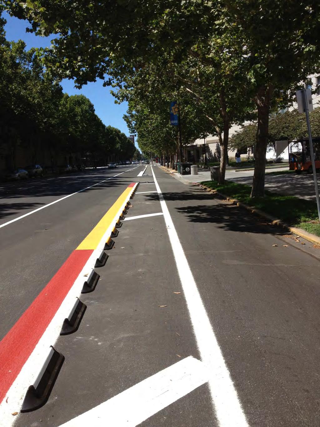
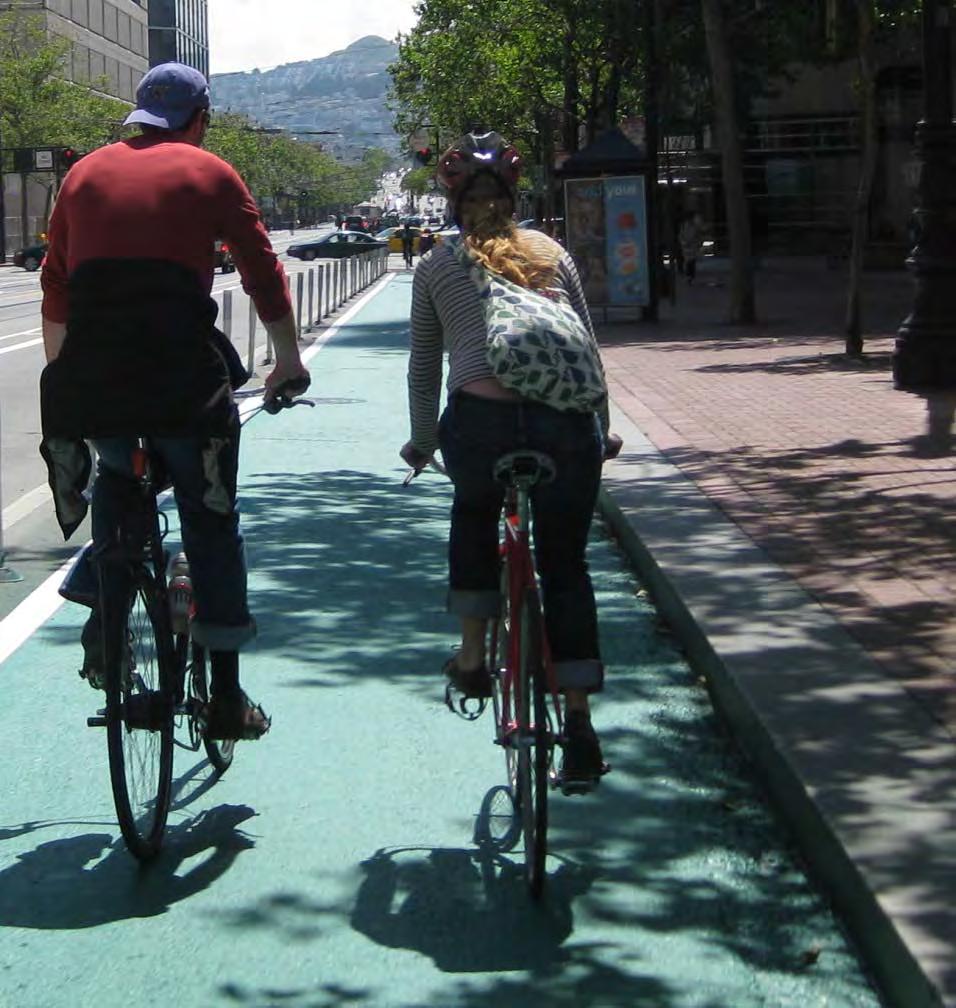
15 SAFE BICYCLE LANES


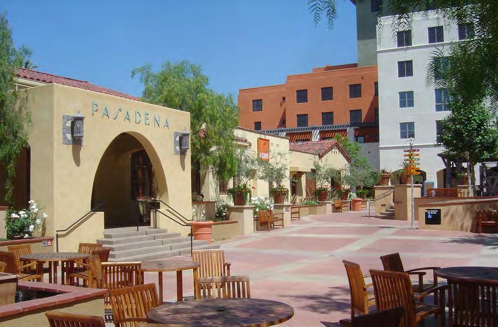
16 GROUND-FLOOR RETAIL Pasadena Old Town Sacramento transparent retail facade 4 th St, Berkeley Pasadena Old Town

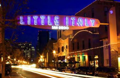
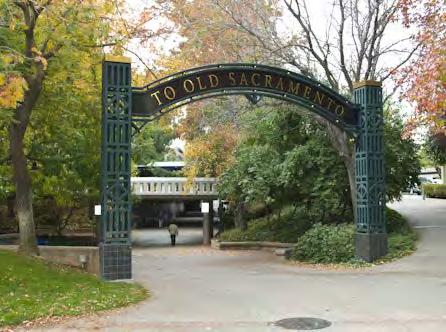
17 GATEWAYS + IDENTITY
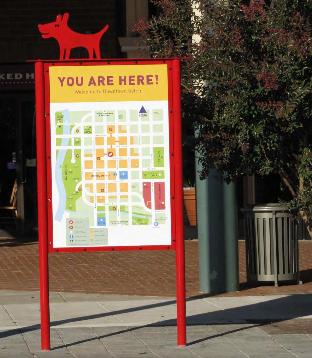
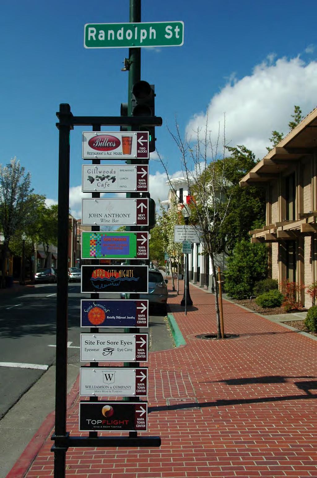
18 WAYFINDING - SIGNAGE

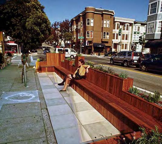
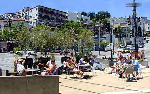
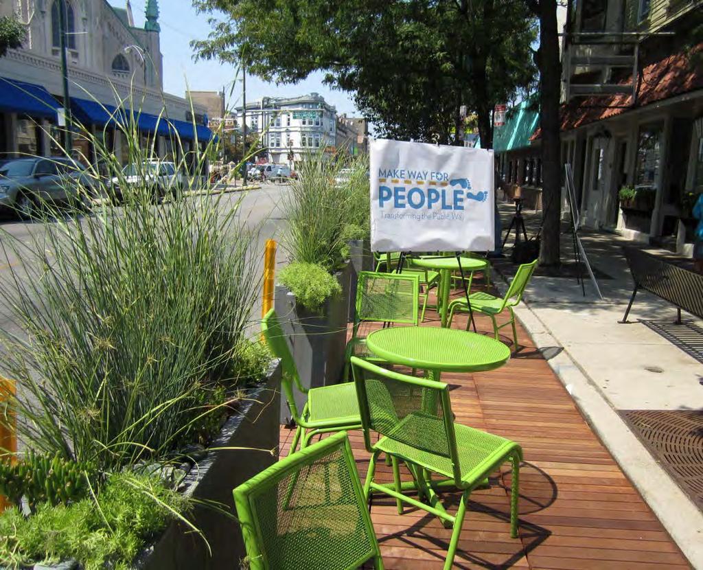
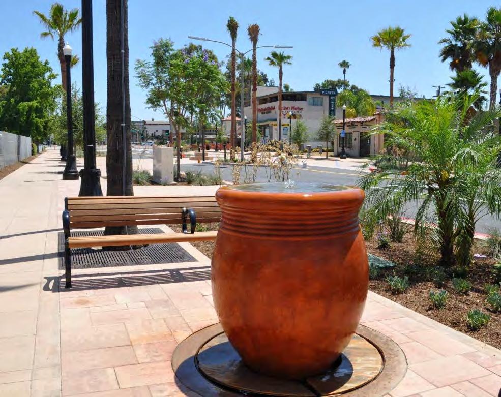
19 OUTDOOR SEATING

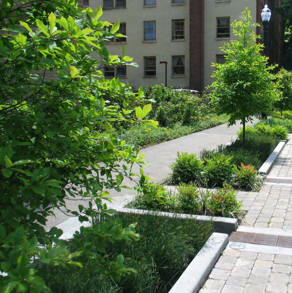
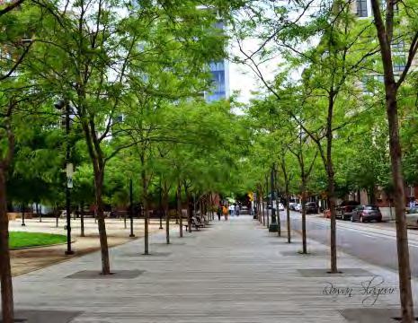
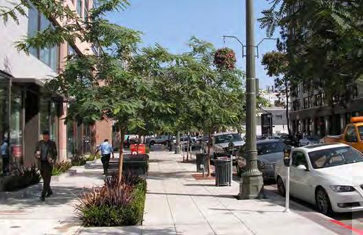
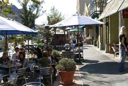
20 TREES + PLANTING

21 PACHECO STREET CLAY ALLEY

22 PACHECO STREET CLAY ALLEY

23 SALVIO STREET, 1930s


24 ALLEYS + PASEOS residential alley mixed-use alley boutique retail alley residential alley

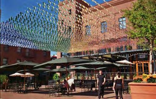
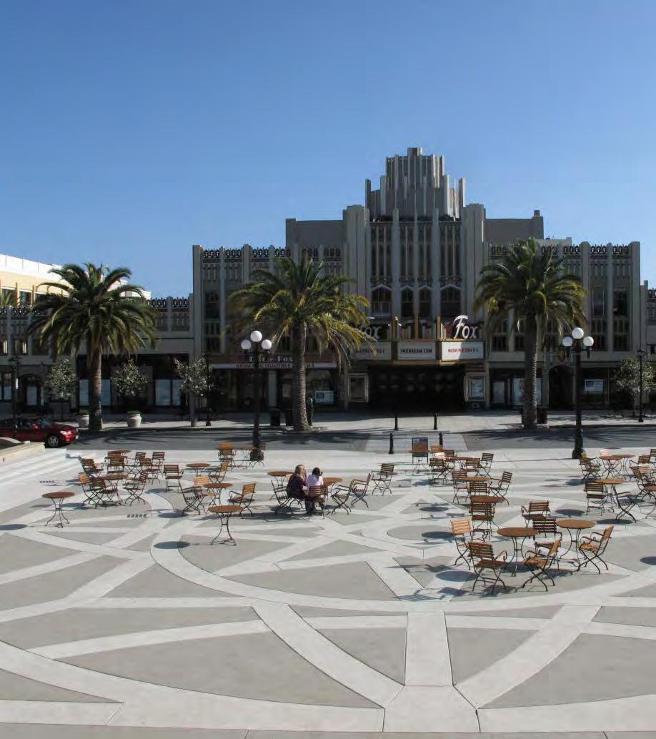
25 PUBLIC PLAZAS


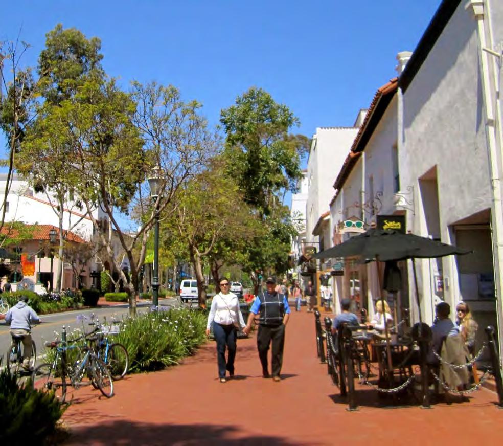
26 WIDE SIDEWALKS

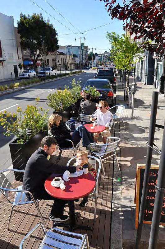
27 OUTDOOR DINING
28 Development Alternatives


29 EXISTING DEVELOPMENT AREAS Total development in the PDA is estimated based on secondary sources of information. Sources included data from slightly outside of the PDA's boundaries. Estimates shown illustrate the scale of development in the PDA in 2011 rather than absolute amount of development. 2,840,000 33% of total GFA 4,250,000 50% of total GFA RESIDENTIAL SF RETAIL SF OFFICE SF LIVE-WORK SF * 1,500,000 17% of total GFA *assuming average unit size of 1,000sf
30 OPTION A: JOBS FOCUS
31 OPTION A: JOBS FOCUS
32 OPTION A: JOBS FOCUS MARKET- RATE HOUSING 4,477,800 72% of total GFA 306,000 5% 1,272,000 20% Residential density 50du/acre 130du/acre (assuming DOWNTOWN average CONCORD 1,000sf SPECIFIC unit) PLAN 208,700 3% TOWNHOMES WORK- LIVE LOFTS RESIDENTIAL SF RETAIL SF OFFICE SF LIVE-WORK SF *excluding Phases I-II Renaissance Housing TOTAL 1,170 units 210 units 240 units 1,620 units 4,100 residents 14,900 employees * GFA Block A OFFICE 488, Block B RETAIL 56, OFFICE 890,988 OFFICE 423,570 Block C OFFICE 135, RETAIL 22,500 Block D OFFICE 538, PARKING STRUCTURE STRUCTURE 319,488 Block E RESIDENTIAL 60, Block F RESIDENTIAL 97, Block G RESIDENTIAL 113, Block H RESIDENTIAL 113, Block I RESIDENTIAL 108, Block J RETAIL 50, Block K OFFICE 382, Block L RESIDENTIAL 119, Block M OFFICE 167, Block N RESIDENTIAL 143, Block O RESIDENTIAL 58, Block P MIXED-USE (live-work) 201, Block Q RETAIL 14, Block R RETAIL 22, MIXED-USE (live-work) 28,800 Block S RETAIL 15, OFFICE 88,416 Block T RESIDENTIAL 13, RESIDENTIAL 99,081 RETAIL 12,074 MIXED-USE (live-work) 75,600 Block U RESIDENTIAL 101, RESIDENTIAL 162,364 Block V RESIDENTIAL 99, RESIDENTIAL 22,140 RESIDENTIAL 120,900 RETAIL 11,309 Block W OFFICE 172, FAR
33 OPTION B: HOUSING FOCUS

34 OPTION B: HOUSING FOCUS
 TOTAL RESIDENTIAL SF RETAIL SF OFFICE SF LIVE-WORK SF *excluding Phases I-II Renaissance Housing 3,220 units 200 units 240 units 3,660 units 9,200 residents 3,100 employees * GFA FAR Block A")
35 OPTION B: HOUSING FOCUS 928,900 20% 198,500 4% MARKET- RATE HOUSING 306,000 7% 3,235,100 69% of total GFA TOWNHOMES WORK- LIVE LOFTS Residential density 50du/acre 130du/acre (assuming average 1,000sf unit) TOTAL RESIDENTIAL SF RETAIL SF OFFICE SF LIVE-WORK SF *excluding Phases I-II Renaissance Housing 3,220 units 200 units 240 units 3,660 units 9,200 residents 3,100 employees * GFA FAR Block A RESIDENTIAL 271, Block B RESIDENTIAL 47, RESIDENTIAL 377,715 RETAIL 59,123 Block C RESIDENTIAL 46, RETAIL 12,779 Block D RESIDENTIAL 260, PARKING STRUCTURE 319,488 Block E RESIDENTIAL 60, Block F RESIDENTIAL 97, Block G RESIDENTIAL 113, Block H RESIDENTIAL 113, Block I RESIDENTIAL 108, Block J RETAIL 50, Block K OFFICE 382, Block L RESIDENTIAL 119, Block M RESIDENTIAL 106, Block N RESIDENTIAL 143, Block O RESIDENTIAL 58, Block P MIXED-USE (live-work) 201, Block Q RETAIL 14, Block R RETAIL 22, MIXED-USE (live-work) 28,800 Block S RETAIL 15, RESIDENTIAL 58,122 Block T RESIDENTIAL 13, RESIDENTIAL 99,081 RETAIL 12,074 MIXED-USE (live-work) 75,600 Block U RESIDENTIAL 101, RESIDENTIAL 162,364 Block V RESIDENTIAL 99, RESIDENTIAL 22,140 RESIDENTIAL 120,900 RETAIL 11,309 Block W RESIDENTIAL 153, RESIDENTIAL 0 Block X RETAIL 477, Block Y OFFICE 301, Block Z OFFICE 244,
36 OPTION C: LIVE-WORK BALANCE
37 OPTION C: LIVE-WORK BALANCE
38 OPTION C: LIVE-WORK BALANCE 2,438,500 47% of total GFA MARKET- RATE HOUSING 306,000 6% 225,500 4% 2,265,000 43% of total GFA TOWNHOMES WORK- LIVE LOFTS Residential DOWNTOWN density CONCORD 50du/acre SPECIFIC 130du/acre PLAN (assuming average 1,000sf unit) RESIDENTIAL SF RETAIL SF OFFICE SF LIVE-WORK SF *excluding Phases I-II Renaissance Housing TOTAL 2,050 units 180 units 240 units 2,470 units 6,200 residents 8,100 employees * GFA FAR Block A RESIDENTIAL 271, Block B RESIDENTIAL 18, RESIDENTIAL 155,613 RETAIL 53,482 OFFICE 41,390 OFFICE 428,322 Block C OFFICE 135, RETAIL 22,500 Block D RESIDENTIAL 260, PARKING STRUCTURE 319,488 Block E RESIDENTIAL 60, Block F RESIDENTIAL 97, Block G RESIDENTIAL 113, Block H RESIDENTIAL 113, Block I RESIDENTIAL 108, Block J RETAIL Block K OFFICE 382, Block L RESIDENTIAL 119, Block M RESIDENTIAL 17,513 RESIDENTIAL 106,527 RETAIL 13,523 Block N RESIDENTIAL 143, Block O RESIDENTIAL 58, Block P MIXED-USE (live-work) 201, Block Q RETAIL 14, Block R RETAIL 22, MIXED-USE (live-work) 28,800 Block S RETAIL 15, OFFICE 88,416 Block T RESIDENTIAL 13, RESIDENTIAL 99,081 RETAIL 12,074 MIXED-USE (live-work) 75,600 Block U RESIDENTIAL 101, RESIDENTIAL 162,364 Block V RESIDENTIAL 99, RESIDENTIAL 22,140 RESIDENTIAL 120,900 RETAIL 11,309 Block W OFFICE 172, Block X OFFICE 644, Block Y OFFICE 301, Block Z OFFICE 244, Block A1 RETAIL 9,

39 PROGRAM COMPARISON OPTION A OPTION B OPTION C 306,000 5% 1,272,000 20% 208,800 3% 928,900 20% 306,000 7% 306,000 6% 2,265,000 43% 4,477,800 72% 198,500 4% 3,235,100 69% 2,438,500 47% 225,500 4% * *excluding Phases I-II Renaissance Housing
40 PROGRAM COMPARISON 6,250,000 SF 4,650,000 SF 5,250,000 SF NEW DEVELOPMENT AREA 8,600,000 SF 8,600,000 SF 8,600,000 SF EXISTING DEVELOPMENT AREA OPT A OPT B OPT C
41
42 Transportation Metrics
43 STREET TYPOLOGIES
44 STREET TYPOLOGIES Auto Dominant Highway Freeways & approach that serve high volumes of high speed regional motor vehicle traffic. Transbay and express transit buses are also accommodated. Bicycles and pedestrians are prohibited. Transit Street Primary routes for CCCTA, Tri-Delta Transit & downtown shuttle. Signal preemption for transit vehicles, bus stops, bus lanes where appropriate. Accommodate mid-high volumes of through traffic. Pedestrian amenities enhanced around bus stops. Connector Street Accommodates automobiles, bicycles & trucks equally. Mid-high volumes of through traffic within and beyond the city. Local Street Accommodates automobiles, bicycles & trucks equally. Low volumes of local traffic, primarily provide access to property. Through traffic is discouraged. Traffic calming techniques to slow and discourage through automobile and truck traffic. Bicycle Boulevard Routes for bicycles providing continuous access & connections to the bicycle route network. Through motor vehicle traffic discouraged. Traffic calming techniques to slow and discourage through automobile and truck traffic.
45 STREET TYPOLOGIES Major Transit Hub Transfer points where high volume transit lines intersect (BART station). Bicycle Path Class I Bicycle path as defined by Caltrans standards accommodates both bicycles and pedestrians. Motor vehicle traffic is prohibited. Bike Route Class II (bike lanes) or Class III (signed route) bike facilities as defined by Caltrans standards, are overlaid on transit, connector, and local streets. Pedestrian Path These are exclusive walkways for pedestrians. Bicycles and motor vehicles are prohibited. Pedestrian Priority Street Frontage Streets on which high volumes of pedestrian traffic are encouraged. Sidewalks should be wide with ample pedestrian amenities. Building frontages should provide high level of pedestrian interest. Pedestrian crossings should have a high priority at intersections. In some locations, wellprotected mid-block crosswalks may be appropriate. Roadways connecting to the BART station should have pedestrian priority.
46 STREET TYPOLOGIES Modal Priorities in SPA Clayton Road, Concord Road, Concord Boulevard and portions of Willow Pass potential for Transit Street Detroit, Laguna, Oak, Oakland, Grant, Bonifacio, East, Harrison potential for Bicycle Boulevard Market Street potential for Connector Street Downtown core including portion of Willow Pass and Grant Street connecting to BART; Pedestrian priority zone.
47 TRANSPORTATION FACILITIES MATRIX Facility Transit Bicycles Pedestrians Autos Transit Street /1/ Bicycle Boulevard Bicycle Path (class I) Pedestrian Path Connector Street /1/ Local Street /1/ Auto Dominant Road = Dominant = Accommodated = Incidental = Prohibited /1/Bike routes (class II and III) can be overlaid on these street types.
48 TRANSPORTATION METRICS Transportation Metric Gross Daily Trips (includes auto, bike, walk, transit) Existing Option A: Jobs Focus Option B: Housing Focus Option C: Balanced 111,300 44,200 41,900 41,500 Daily BART Trips 10,700 2,600 3,000 2,700 Daily Internal Capture (assumed to be walk/bike) 13% (14,800) 14% (22,200) 16% (23,900) 15% (22,600) Daily External Bike/Walk Trips 8% (7,600) 10% (13,100) 12% (14,900) 11% (13,700) Daily Transit Mode Share 15% (14,100) 14% (18,900) 15% (19,200) 14% (18,800) Daily Vehicle Trips 74,800 26,600 20,500 22,900 AM Peak Hour Trips 6,100 3,300 1,400 2,200 PM Peak Hour Trips 5,700 4,100 1,600 2,700
49 KEY TRANSPORTATION TAKEAWAYS OPTION A Generates the most vehicle trips & fewer trips with origins and destinations in Specific Plan Area; highest impact on intersection and roadway segment operations Least impact to BART as most morning trips would be in the eastbound direction where there is additional capacity OPTION B Generates the least vehicle trips & results in more trips with both origin & destination in Specific Plan Area; the least impact to intersection operations Greater impact on BART, as most morning trips would be in the westbound direction which is already at or approaching capacity for much of peak hour Balances high levels of existing office development with internalization of trips OPTION C Balances the pros/cons of OPTIONS A & B
50 NEXT STEPS Analyze intersection & roadway segment operations with the preferred alternative under the following scenarios: Existing Plus Project Cumulative Plus Project Provide suggestions in the refinement of final Project Alternative to minimize transportation impacts & develop mitigation measures that further the City s goals for this project

51 Next steps Tonight - Discussion of Alternatives, Streetscape Proposals July 22 nd - DSC #5 Evaluation of Alternatives Late July/Early August - Design team begins to develop Preferred Plan August 5 th - DSC #6 Preview and discussion of Preferred Plan August 27 th - Workshop #2; Presentation of Preferred Plan September 15 th Design team prepares first draft Specific Plan
52
DOWNTOWN CONCORD SPECIFIC PLAN
 Timeline Next Milestones Alternatives Analysis Draft Report to MTC - July 30 Draft Specific Plan Outline July 31 First Draft Specific Plan Report September 15 Schedule and Agendas July 22 nd DSC #5 Evaluation
Downtown Parking/Wayfinding Study. Review of Recommendations to City Council: January 16, 2018
 Downtown Parking/Wayfinding Study Review of Recommendations to City Council: January 16, 2018 Tonight s Focus Objectives & Timeline Recap Study Findings Present Staff Recommendations 2018 Action items
BROWARD BOULEVARD CORRIDOR TRANSIT STUDY
 BROWARD BOULEVARD CORRIDOR TRANSIT STUDY FM # 42802411201 EXECUTIVE SUMMARY July 2012 GOBROWARD Broward Boulevard Corridor Transit Study FM # 42802411201 Executive Summary Prepared For: Ms. Khalilah Ffrench,
2.0 Development Driveways. Movin Out June 2017
 Movin Out June 2017 1.0 Introduction The proposed Movin Out development is a mixed use development in the northeast quadrant of the intersection of West Broadway and Fayette Avenue in the City of Madison.
Agenda. Preliminary Station Footprint High Speed Train Station in the City of Millbrae
 Agenda Preliminary Station Footprint High Speed Train Station in the City of Millbrae Open House 7:00 7:30 Presentation 7:30 8:00 Community Question/Answer 8:00 9:00 Adjourn 2 Preliminary Station Footprint
IMPROVEMENT CONCEPTS
 IMPROVEMENT CONCEPTS for the South Novato Transit Hub Study Prepared by: January 11, 2010 DKS Associates With Wilbur Smith Associates IMPROVEMENT CONCEPTS Chapter 1: Introduction 1. INTRODUCTION The strategic
CORE AREA SPECIFIC PLAN
 only four (A, B, D, and F) extend past Eighth Street to the north, and only Richards Boulevard leaves the Core Area to the south. This street pattern, compounded by the fact that Richards Boulevard is
This Evening s Agenda. Open House 7:00 7:30 Presentation 7:30 8:00 Community Feedback8:00 9:00 Adjourn
 This Evening s Agenda Open House 7:00 7:30 Presentation 7:30 8:00 Community Feedback8:00 9:00 Adjourn Preliminary Station Footprint Potential Mid-Peninsula High Speed Train Station Palo Alto Dominic Spaethling,
Develop ground transportation improvements to make the Airport a multi-modal regional
 Project Overview TRANSPORTATION IMPROVEMENTS WHAT ARE THE PROJECT GOALS? Transportation transportation hub. Develop ground transportation improvements to make the Airport a multi-modal regional Land Use
Troost Corridor Transit Study
 Troost Corridor Transit Study May 23, 2007 Kansas City Area Transportation Authority Agenda Welcome Troost Corridor Planning Study Public participation What is MAX? Survey of Troost Riders Proposed Transit
Downtown Transit Connector. Making Transit Work for Rhode Island
 Downtown Transit Connector Making Transit Work for Rhode Island 3.17.17 Project Evolution Transit 2020 (Stakeholders identify need for better transit) Providence Core Connector Study (Streetcar project
IV. ENVIRONMENTAL IMPACT ANALYSIS K.2. PARKING
 IV. ENVIRONMENTAL IMPACT ANALYSIS K.2. PARKING ENVIRONMENTAL SETTING The following analysis summarizes the findings and conclusions of the Traffic Analysis (Traffic Study), prepared by The Mobility Group,
Fresno County. Sustainable Communities Strategy (SCS) Public Workshop
 Public Workshop") Fresno County Sustainable Communities Strategy (SCS) Public Workshop Project Background Senate Bill 375 Regional Transportation Plan (RTP) Greenhouse gas emission reduction through integrated transportation
Fresno County Sustainable Communities Strategy (SCS) Public Workshop Project Background Senate Bill 375 Regional Transportation Plan (RTP) Greenhouse gas emission reduction through integrated transportation
4 Circulation & Transportation
 4.1 Mobility Network The mobility network at the new St. Paul s hospital and health campus is comprised of an interconnected system of sidewalks, cycle paths, transit routes and roadways. Figure 4-1: Indicative
Railyard Alternatives & I-280 Boulevard Feasibility Study 1 RAILYARD ALTERNATIVES & I-280 BOULEVARD (RAB) FEASIBILITY STUDY
 FEASIBILITY STUDY") Railyard Alternatives & I-280 Boulevard Feasibility Study 1 RAILYARD ALTERNATIVES & I-280 BOULEVARD (RAB) FEASIBILITY STUDY RAB Citizen Working Group Meeting, August 1 st 2016 CITIZEN WORKING GROUP (CWG)
Railyard Alternatives & I-280 Boulevard Feasibility Study 1 RAILYARD ALTERNATIVES & I-280 BOULEVARD (RAB) FEASIBILITY STUDY RAB Citizen Working Group Meeting, August 1 st 2016 CITIZEN WORKING GROUP (CWG)
Transportation Sustainability Program
 Transportation Sustainability Program Photo: Sergio Ruiz San Francisco 2016 Roads and public transit nearing capacity Increase in cycling and walking despite less than ideal conditions 2 San Francisco
Garrett Hill Master Plan
 Garrett Hill Master Plan Visioning Workshop February 13, 2007 Campbell Thomas & Company Agenda Welcome Existing conditions summary Critical issues Visioning exercise Summary & next steps Critical Assets
Central Loop Bus Rapid Transit
 Central Loop Bus Rapid Transit Transportation Goals of the Chicago Central Area ACTION Plan, page 2-6 Central Area Plan Improve Transit in Central Area Improve Pedestrian Environment Manage Traffic Circulation
TRANSPORTATION REVIEW
 TRANSPORTATION REVIEW - PROPOSED MIX OF LAND USES IS CONSISTENT WITH THE CITY S UNDER THE GRANVILLE BRIDGE POLICIES THAT AIM TO MEET NEIGHBOURING RESIDENTS SHOPPING NEEDS AND REDUCE RELIANCE ON AUTOMOBILE
CTfastrak Expansion. Stakeholder Meeting #4 Manchester Town Hall June 3, 2016
 CTfastrak Expansion Stakeholder Meeting #4 Manchester Town Hall June 3, 2016 Today s Agenda Phase I Update 2016 Service Plan Implementation Schedule & Cost Update Phase II Services Timeline Market Analysis
METRO Orange Line BRT American Boulevard Station Options
 METRO Orange Line BRT American Boulevard Station Options Bloomington City Council Work Session November 18, 2013 Christina Morrison BRT/Small Starts Project Office Coordinating Planning and Design AMERICAN
BERKELEY DOWNTOWN AREA PLAN PROGRAM ENVIRONMENTAL IMPACT REPORT TRAFFIC IMPACT ANALYSIS
 BERKELEY DOWNTOWN AREA PLAN PROGRAM ENVIRONMENTAL IMPACT REPORT TRAFFIC IMPACT ANALYSIS Prepared for: City of Berkeley Prepared by: REVISED JANUARY 9, 2009 Berkeley Downtown Area Plan Program EIR Traffic
Click to edit Master title style
 Nelson/Nygaard Consulting Associates SERVICE IMPROVEMENT STRATEGIES September 22, 2015 1 PROJECT OVERVIEW & WORK TO DATE 1. Extensive stakeholder involvement Throughout 2. System and market assessment
Public transit, automobile traffic and loading
 TASK 3.1 Public transit, automobile traffic and loading 1: Timeline Update and Project Approach 2: Transportation Conditions and Challenges 3: Zoning Strategies 4: Next Steps Stuart Street Planning Study
Waco Rapid Transit Corridor (RTC) Feasibility Study
 Feasibility Study") Waco Rapid Transit Corridor (RTC) Feasibility Study Chris Evilia, Director of Waco Metropolitan Planning Organization Allen Hunter, General Manager Waco Transit System Jimi Mitchell, Project Manager AECOM
Waco Rapid Transit Corridor (RTC) Feasibility Study Chris Evilia, Director of Waco Metropolitan Planning Organization Allen Hunter, General Manager Waco Transit System Jimi Mitchell, Project Manager AECOM
A Transit Plan for the Future. Draft Network Plan
 A Transit Plan for the Future Draft Network Plan Project Overview and Status Completed Market Analysis and Service Evaluation. Developed Plan Framework and Guiding Principles. Developed a draft Five Year
Draft Transportation Demand Management Program for the Oak Knoll Project
 Draft Transportation Demand Management Program for the Oak Knoll Project Prepared for: Oak Knoll Venture Acquisition City of Oakland OK14-0026 Table of Contents INTRODUCTION AND PROJECT OVERVIEW... 1 Project
appendix 4: Parking Management Study, Phase II
 appendix 4: Parking Management Study, Phase II A4-1 A4-2 Eastlake Parking Management Study Final Phase 2 Report Future Parking Demand & Supply January 6, 2017 Submitted by Denver Corp Center III 7900 E.
APPENDIX VMT Evaluation
 APPENDIX 2.7-2 VMT Evaluation MEMORANDUM To: From: Mr. Jonathan Frankel New Urban West, Incorporated Chris Mendiara LLG, Engineers Date: May 19, 2017 LLG Ref: 3-16-2614 Subject: Villages VMT Evaluation
Appendix C. Parking Strategies
 Appendix C. Parking Strategies Bremerton Parking Study Introduction & Project Scope Community concerns regarding parking impacts in Downtown Bremerton and the surrounding residential areas have existed
Kendall Drive Premium Transit PD&E Study Project Kick-Off Meeting SR 94/Kendall Drive/SW 88 Street Project Development and Environment (PD&E) Study
 Study") Florida Department of Transportation District Six Kendall Drive Premium Transit PD&E Study Project Kick-Off Meeting SR 94/Kendall Drive/SW 88 Street Project Development and Environment (PD&E) Study What
Florida Department of Transportation District Six Kendall Drive Premium Transit PD&E Study Project Kick-Off Meeting SR 94/Kendall Drive/SW 88 Street Project Development and Environment (PD&E) Study What
2030 Multimodal Transportation Study
 2030 Multimodal Transportation Study City of Jacksonville Planning and Development Department Prepared by Ghyabi & Associates April 29,2010 Introduction Presentation Components 1. Study Basis 2. Study
San Francisco Transportation Plan Update
 San Francisco Transportation Plan Update SPUR August 1, 2011 www.sfcta.org/movesmartsf twitter.com/sanfranciscota www.facebook.com/movesmartsf How does the RTP relate to the SFTP? Regional Transportation
CTA Blue Line Study Area
 CTA Blue Line Study Area HISTORY OF THE CTA BLUE LINE / I-290 SYSTEM Blue Line / I-290 infrastructure is 55 years old First integrated transit / highway facility in the U.S. PROJECT STUDY AREA EXISTING
Executive Summary. Treasure Valley High Capacity Transit Study Priority Corridor Phase 1 Alternatives Analysis October 13, 2009.
 Treasure Valley High Capacity Transit Study Priority Corridor Phase 1 Alternatives Analysis October 13, 2009 Background As the Treasure Valley continues to grow, high-quality transportation connections
6/6/2018. June 7, Item #1 CITIZENS PARTICIPATION
 June 7, 2018 Item #1 CITIZENS PARTICIPATION 1 Item #2 APPROVAL OF MINUTES Item #3 TRAC GOALS, FRAMEWORK & AGENDA REVIEW 2 COMMITTEE GOALS Learn about Southern Nevada s mobility challenges, new developments
The Re:Queen and Sparks Traffic Brief - Addendum #2
 June 11, 2015 Ashcroft Homes 18 Antares Drive Ottawa, ON K2E 1A9 EMAIL: mpham@ashcrofthomes.com Attention: May Pham Development Planner Dear May, Re: The Re:Queen and Sparks Traffic Brief - Addendum #2
PROJECT SCHEDULE. Plan for Implementation. Explore and Analyze. Refine Ideas. Identify Common Ideas SPRING 2016 SUMMER 2016 FALL 2016
 VISION WORKSHOP MAY 25 th 2016 A COLLABORATION PROJECT SCHEDULE Explore and Analyze Identify Common Ideas Refine Ideas Plan for Implementation SPRING 2016 SUMMER 2016 FALL 2016 TODAY S AGENDA Explore and
Energy Technical Memorandum
 Southeast Extension Project Lincoln Station to RidgeGate Parkway Prepared for: Federal Transit Administration Prepared by: Denver Regional Transportation District May 2014 Table of Contents Page No. Chapter
3.15 SAFETY AND SECURITY
 3.15 SAFETY AND SECURITY Introduction This section describes the environmental setting and potential effects of the alternatives analyzed in this EIR with regard to safety and security in the SantaClara-Alum
Parking Management Element
 Parking Management Element The State Transportation Planning Rule, adopted in 1991, requires that the Metropolitan Planning Organization (MPO) area implement, through its member jurisdictions, a parking
Preliminary Definition of Alternatives. 3.0 Preliminary Definition of Alternatives
 3.0 What preliminary alternatives are being evaluated? The alternatives for the East San Fernando Valley Transit Corridor project that were considered for screening include the No Build Alternative, Transportation
San Francisco Transportation Plan
 San Francisco Transportation Plan Overview and Findings to Date November 13, 2012 www.sfcta.org/movesmartsf twitter.com/sanfranciscota www.facebook.com/movesmartsf Purpose of the SFTP San Francisco s long-range
Green Line Long-Term Investments
 Enhancements Short-term improvements to keep Austin moving. Investments Long-term projects to support our future. Mobility Hubs MetroRapid MetroRail MetroExpress Connectors Circulators Project Connect
5. OPPORTUNITIES AND NEXT STEPS
 5. OPPORTUNITIES AND NEXT STEPS When the METRO Green Line LRT begins operating in mid-2014, a strong emphasis will be placed on providing frequent connecting bus service with Green Line trains. Bus hours
San Francisco Mobility, Access & Pricing Study
 San Francisco Mobility, Access & Pricing Study SAN FRANCISCO COUNTY TRANSPORTATION AUTHORITY Summer Workshops 2010 Downtown Growth Projections + 24,000 hsg units + 107,000 jobs +184,000 auto trips +88,000
Amman Green Policies Projects and Challenges. Prepared by: Eng. Sajeda Alnsour Project coordinator Sept. 20, 2017
 Amman Green Policies Projects and Challenges Prepared by: Eng. Sajeda Alnsour Project coordinator Sept. 20, 2017 Amman: Demographics Greater AMMAN Municipality GAM Amman is the capital of Jordan with a
1 Downtown LRT Connector: Draft Concept
 Downtown LRT Connector: Draft Concept Plan November 2010 We re moving forward. Get involved. On June 21, 2010, City Council approved a street-level downtown LRT route, including a connector for the future
Reston Transportation Strategy July 9, 2018
 Reston Transportation Strategy July 9, 2018 Background: On February 11, 2014, the Board of Supervisors adopted the Reston Phase I Comprehensive Plan Amendment for the core areas of Reston between Sunset
Escondido Marriott Hotel and Mixed-Use Condominium Project TRAFFIC IMPACT ANALYSIS REPORT
 Escondido Marriott Hotel and Mixed-Use Condominium Project TRAFFIC IMPACT ANALYSIS REPORT Prepared for Phelps Program Management 420 Sixth Avenue, Greeley, CO 80632 Prepared by 5050 Avenida Encinas, Suite
SAN FRANCISCO MUNICIPAL TRANSPORTATION AGENCY BOARD OF DIRECTORS. RESOLUTION No
 SAN FRANCISCO MUNICIPAL TRANSPORTATION AGENCY BOARD OF DIRECTORS RESOLUTION No. 16-036 WHEREAS, The San Francisco Municipal Transportation Agency has received a request, or identified a need for traffic
Executive Summary. Draft Environmental Impact Statement/Environmental Impact Report ES-1
 Executive Summary Introduction The Eastside Transit Corridor Phase 2 Project is a vital public transit infrastructure investment that would provide a transit connection to the existing Metro Gold Line
Office of Transportation Bureau of Traffic Management Downtown Parking Meter District Rate Report
 Office of Transportation Bureau of Traffic Management 1997 Downtown Parking Meter District Rate Report Introduction The City operates approximately 5,600 parking meters in the core area of downtown. 1
Draft Results and Open House
 Waco Rapid Transit Corridor (RTC) Feasibility Study Draft Results and Open House Chris Evilia, Director of Waco Metropolitan Planning Organization Allen Hunter, General Manager Waco Transit System Jimi
Unified Corridor Investment Study DRAFT Step 2 Scenario Analysis Report
 Unified Corridor Investment Study DRAFT Step 2 Scenario Analysis Report REVISIONS 1. Table 39: New Public Investments for Operation and Maintenance Costs 2. Appendix A-10: Passenger Rail Service - Operations
SANDAG 3D Visualization Howard Blackson 6:15. Sub Area A Coalition Massing/Phasing - Mike Labarre 6:30
 Agenda Grantville Master Plan Stakeholders Committee Meeting April 13, 2009 SANDAG 3D Visualization Howard Blackson 6:15 Sub Area A Coalition Massing/Phasing - Mike Labarre 6:30 Land Use and Street Alternatives
STH 60 Northern Reliever Route Feasibility Study Report
 #233087 v3 STH 60 Northern Reliever Route Feasibility Study Report Washington County Public Works Committee Meeting September 28, 2016 1 STH 60 Northern Reliever Route Feasibility Study Hartford Area Development
Downtown Community Plan Adopted April 2006
 Downtown Community Plan Adopted April 2006 Chapter 5.8 Goals and Policies: Sustainable Development Far Bonus Program: Eco-Roof Urban plazas, street activation and Neighborhood Centers Suburban vs. Urban
West Broadway Transit Study. Community Advisory Committee September 17, 2015
 West Broadway Transit Study Community Advisory Committee September 17, 2015 Introductions Community Engagement Summer Outreach Fall Outreach Technical Analysis Process Update Alternatives Review Economic
Planning for Downtown Parking. April 7, 2010 Planning Commission
 Planning for Downtown Parking April 7, 2010 Planning Commission Introduction Review of 2009 Parking Study: Scope: Downtown Data collection Existing conditions Private and Public Parking Utilization Future
UTA Transportation Equity Study and Staff Analysis. Board Workshop January 6, 2018
 UTA Transportation Equity Study and Staff Analysis Board Workshop January 6, 2018 1 Executive Summary UTA ranks DART 6 th out of top 20 Transit Agencies in the country for ridership. UTA Study confirms
SOUTHERN GATEWAY. Transportation and Trinity River Project Committee 11 May 2015
 SOUTHERN GATEWAY Transportation and Trinity River Project Committee 11 May 2015 Southern Gateway Project History Began in 2001 as a Major Investment Study [ MIS ], Schematic, and Environmental Assessment
ANDERSON PROPERTY SITE ANALYSIS
 ANDERSON PROPERTY SITE ANALYSIS Introduction The Montgomery County Department of Transportation (MCDOT) initiated a feasibility study in the fall of 2012 to evaluate the need for transit service expansion
APPENDIX H. Transportation Impact Study
 APPENDIX H Transportation Impact Study BUENA VISTA LAGOON ENHANCEMENT PROJECT TRANSPORTATION IMPACT STUDY Prepared for: San Diego Association of Governments Prepared by: VRPA Technologies, Inc. 9520 Padgett
2. Valley Circle Boulevard/Andora Avenue/Baden Avenue and Lassen Street
 IV.J TRANSPORTATION 1. INTRODUCTION This section presents an overview of the existing traffic and circulation system in and surrounding the project site. This section also discusses the potential impacts
NEW ELEMENTARY SCHOOL #1 Open BLPC Meeting January 9, 2013
 NEW ELEMENTARY SCHOOL #1 Open BLPC Meeting January 9, 2013 It s for the Students! Maintain class size Hold fewer classes in relocatables Minimize travel distance to school Project Delay and it s impact
Draft Results and Recommendations
 Waco Rapid Transit Corridor (RTC) Feasibility Study Draft Results and Recommendations Chris Evilia, Director of Waco Metropolitan Planning Organization Allen Hunter, General Manager Waco Transit System
EUGENE-SPRINGFIELD, OREGON EAST WEST PILOT BRT LANE TRANSIT DISTRICT
 EUGENE-SPRINGFIELD, OREGON EAST WEST PILOT BRT LANE TRANSIT DISTRICT (BRIEF) Table of Contents EUGENE-SPRINGFIELD, OREGON (USA)... 1 COUNTY CONTEXT AND SYSTEM DESCRIPTION... 1 SYSTEM OVERVIEW... 1 PLANNING
Planned Development Application 1450 Sherman Avenue Evanston, IL TRAFFIC CIRCULATION IMPACT STUDY
 Planned Development Application 1450 Sherman Avenue Evanston, IL 60201 14 TRAFFIC CIRCULATION IMPACT STUDY Traffic Impact Study 1454 Sherman Mixed-Use Development Evanston, Illinois Prepared for Prepared
East Turnaround. Access to Ayreswood Avenue would be restricted to right-in/rightout movements under the proposed Rapid Transit plan.
 East Turnaround Options at Fanshawe College Ayreswood Access Access to Ayreswood Avenue would be restricted to right-in/rightout movements under the proposed Rapid Transit plan. To mitigate the impacts
City of Pacific Grove
 Regional Study Utilizing Caltrans Intersection Evaluation Section 7: City of Pacific Grove s: FIRST STREET AT CENTRAL AVENUE Transportation Agency for Monterey County Prepared by Transportation Agency
Craig Scheffler, P.E., PTOE HNTB North Carolina, P.C. HNTB Project File: Subject
 TECHNICAL MEMORANDUM To Kumar Neppalli Traffic Engineering Manager Town of Chapel Hill From Craig Scheffler, P.E., PTOE HNTB North Carolina, P.C. Cc HNTB Project File: 38435 Subject Obey Creek TIS 2022
WELCOME Open House on Parking
 WELCOME Open House on Parking Tonight we re presenting our policy responses for your input on how to best manage our public parking. Parking is a shared community resource. To best serve everyone in our
Taxi Task Force. Work Plan Progress Report, September 9, Updates since the last meeting are highlighted.
 Taxi Task Force Work Plan Progress Report, September 9, 2015 Updates since the last meeting are highlighted. Taxi Driver Recruitment/Retention: Recruitment/retention initiative: o Driver outreach events:
Central City Line Locally Preferred Alternative (LPA) Amendment Public Hearing. July 24, 2014
 Amendment Public Hearing. July 24, 2014") Central City Line Locally Preferred Alternative (LPA) Amendment Public Hearing July 24, 2014 Project Description The Central City Line is a High Performance Transit project that will extend from Browne
Central City Line Locally Preferred Alternative (LPA) Amendment Public Hearing July 24, 2014 Project Description The Central City Line is a High Performance Transit project that will extend from Browne
Capital Metro Downtown Multimodal Station
 Capital Metro Downtown Multimodal Station Stakeholder Briefing December 11, 2015 Agenda 1 2 3 4 5 Project Summary Downtown Station Concept Evaluation 4 th Street Traffic Analysis 5 th Street Traffic Analysis
Appendix A. Community Workshop Results PUBLIC REVIEW DRAFT
 Appendix A Community Workshop Results This Page Left Blank Intentionally Comprehensive Planning Community Workshop Summary July 30, 2012 The City of Becker invited the Community to participate in a Comprehensive
SAN FRANCISCO MUNICIPAL TRANSPORTATION AGENCY
 THIS PRINT COVERS CALENDAR ITEM NO: 10.2 DIVISION: Sustainable Streets BRIEF DESCRIPTION: SAN FRANCISCO MUNICIPAL TRANSPORTATION AGENCY Approving various routine parking and traffic modifications. SUMMARY:
Chapter 4 : THEME 2. Transportation
 Chapter 4 : THEME 2 Strengthen connections to keep the Central Area easy to reach and get around 55 Figure 4.2.1 Promote region-wide transit investments. Metra commuter rail provides service to the east,
Sustainability SFMTA Path to Platinum
 Sustainability SFMTA Path to Platinum Ed Reiskin San Francisco Municipal Transportation Agency, Director of Transportation San Francisco, CA Timothy Papandreou Deputy Director Strategic Planning & Policy
Restoration of Historic Streetcar Services in Downtown Los Angeles
 Restoration of Historic Streetcar Services in Downtown Los Angeles Early Scoping Meeting for Alternatives Analysis (AA) May 17, 2011 Introduction Key players Local lead agency: Metro Federal lead agency:
Public Meeting. City of Chicago Department of Transportation & Department of Housing and Economic Development
 Public Meeting City of Chicago Department of Transportation & Department of Housing and Economic Development Funded by Regional Transportation Authority September 12, 2011 In partnership with Presentation
Fixing the Line s Canarsie Tunnel. Manhattan CB6 11/5/2018
 Fixing the Line s Canarsie Tunnel Manhattan CB6 11/5/2018 Interborough Bus Service 80+ buses in the peak hour in the peak direction over the Williamsburg Bridge Projected to carry 17% of riders 1 Bus Priority
Environmental Assessment Derry Road and Argentia Road Intersection
 Air and Noise Study Environmental Assessment Derry Road and Argentia Road Intersection Project 11-4295 City of Mississauga, Region of Peel October 17, 2014 1 Region of Peel Environmental Assessment for
residents of data near walking. related to bicycling and Safety According available. available. 2.2 Land adopted by
 2. Assessment of Current Conditions and Needs In order to prepare a plan to reach the vision desired by the residents of Texarkana, it is first necessary to ascertain the current situation. Since there
We Want Your Input! Review the design alternatives and tell us what s important to you in the design of these areas of the approved BRT Network:
 We Want Your Input! Review the design alternatives and tell us what s important to you in the design of these areas of the approved BRT Network: Richmond North of Oxford Street Richmond Row Dundas Street
LEED v4 Building Design and Construction Quiz #3 LT
 LEED v4 Building Design and Construction Quiz #3 LT 1. How are walking and bicycling distance measured? A. Straight-line radius from a main building entrance B. Straight-line radius from any building entrance
Welcome. Green Line in Your Community
 Welcome Green Line in Your Community Today's session will provide you with information about Administration's recommendation for connecting the Green Line in the Beltline to Victoria Park and Inglewood/Ramsay
The major roadways in the study area are State Route 166 and State Route 33, which are shown on Figure 1-1 and described below:
 3.5 TRAFFIC AND CIRCULATION 3.5.1 Existing Conditions 3.5.1.1 Street Network DRAFT ENVIRONMENTAL IMPACT REPORT The major roadways in the study area are State Route 166 and State Route 33, which are shown
Streetcar and Light Rail Design Differences. March 2015
 Streetcar and Light Rail Design Differences March 2015 How Are Streetcar and Light Rail Different? The design differences between streetcar and light rail are tied to the distinctions in the markets served
MONTEREY BAY AQUARIUM RESEARCH INSTITUTE (MBARI) MASTER PLAN UPDATE MOSS LANDING, CALIFORNIA
 MASTER PLAN UPDATE MOSS LANDING, CALIFORNIA") MONTEREY BAY AQUARIUM RESEARCH INSTITUTE (MBARI) MASTER PLAN UPDATE MOSS LANDING, CALIFORNIA TRAFFIC IMPACT ANALYSIS Administrative Draft Report Prepared For Monterey Bay Aquarium Research Institute Moss
MONTEREY BAY AQUARIUM RESEARCH INSTITUTE (MBARI) MASTER PLAN UPDATE MOSS LANDING, CALIFORNIA TRAFFIC IMPACT ANALYSIS Administrative Draft Report Prepared For Monterey Bay Aquarium Research Institute Moss
Address Land Use Approximate GSF
 M E M O R A N D U M To: Kara Brewton, From: Nelson\Nygaard Date: March 26, 2014 Subject: Brookline Place Shared Parking Analysis- Final Memo This memorandum presents a comparative analysis of expected
What We Heard Report - Metro Line NW LRT
 What We Heard Report - Metro Line NW LRT by Metro Line NW LRT Project Team LRT Projects City of Edmonton April 11, 2018 Project / Initiative Background Name Date Location Metro Line Northwest Light Rail
TRAFFIC IMPACT STUDY FOR
 TRAFFIC IMPACT STUDY FOR YUBA CROSSINGS MIXED USE DEVELOPMENT Yuba City, CA Prepared For: Yuba Crossings LLC 1825 Del Paso Blvd Sacramento, CA 95815 Prepared By: KDAnderson & Associates, Inc. 3853 Taylor
Jeff s House. Downtown Charlottesville. PEC Office
 Jeff s House Downtown Charlottesville PEC Office Year 2000 US Census Data Employed persons over 16 Percentage of Employed Persons Locality Avg Commute (in minutes) Drove Public Transit Walk/Bike Other
IV. ENVIRONMENTAL IMPACT ANALYSIS N. TRANSPORTATION AND TRAFFIC
 IV. ENVIRONMENTAL IMPACT ANALYSIS N. TRANSPORTATION AND TRAFFIC The following section summarizes the information provided in the traffic report entitled Traffic Impact Analysis for a Proposed Residential
Travel Time Savings Memorandum
 04-05-2018 TABLE OF CONTENTS 1 Background 3 Methodology 3 Inputs and Calculation 3 Assumptions 4 Light Rail Transit (LRT) Travel Times 5 Auto Travel Times 5 Bus Travel Times 6 Findings 7 Generalized Cost
FINAL DESIGN TRAFFIC OPERATIONS REPORT
 IndyGo Red Line Rapid Transit Project Phase 1 FINAL DESIGN TRAFFIC OPERATIONS REPORT IndyGo April, 2016 Table of Contents Section 1 Introduction... 1-1 1.1 Project Description... 1-1 1.2 Existing Conditions...
Transit Hub Case Study: Owings Mills Metro Station. By: Kathleen Cary Rose, J. Luke Byrne and Catherine Buhler
 Executive Summary Transit Hub Case Study: Owings Mills Metro Station By: Kathleen Cary Rose, J. Luke Byrne and Catherine Buhler The purpose of the Transit Hub Case Study is to identify and evaluate the
Station Evaluation. Durham-Orange Light Rail Transit Project Spring 2012
 Station Evaluation Durham-Orange Light Rail Transit Project Spring 2012 Key Ingredients for Station Development Platform Designs UNC Hospitals Station The UNC Hospitals Station Option D would be the westerly