SANDAG 3D Visualization Howard Blackson 6:15. Sub Area A Coalition Massing/Phasing - Mike Labarre 6:30
|
|
|
- Amie Bryan
- 5 years ago
- Views:
Transcription

1 Agenda Grantville Master Plan Stakeholders Committee Meeting April 13, 2009 SANDAG 3D Visualization Howard Blackson 6:15 Sub Area A Coalition Massing/Phasing - Mike Labarre 6:30 Land Use and Street Alternatives J.J. Folsom/Todd Mead 6:35 Next Steps 7:55 Adjournment 8:00
2 Vision Statement Our vision for Grantville in the year 2030 is for the improvement and reestablishment of an older neighborhood in central San Diego. We envision an attractive, balanced community with a desirable quality of life that capitalizes on its proximity to a network of freeways, trolley lines, natural environment, waterways, and open spaces. In the year 2030, Grantville is a community that Respects the vitality and livelihood of locally owned and operated businesses while promoting the expansion of new business opportunities; Contains an appropriate mix of auto, pedestrian, bicycle, and public transportation opportunities for optimum mobility; Offers a variety of housing opportunities while considering neighborhood scale and integrity; Connects residents and visitors to the San Diego River while providing safe and adequate buffers from developed areas; and Contains sufficient public facility amenities such as neighborhood and community parks, libraries, schools, and emergency services.

3 Master Plan Alternatives Market Demand Refined land use alternatives and 3d massing diagrams
4 Economic Analysis (DRAFT by ERA) Market Demand Estimates for new development (allows for absorption of existing vacancies) Land Use Low Mid High Housing (du) 4,000 5,000 6,300 Office sq ft 300, , ,000 Industrial 150, , ,000 Retail (neighborhood)* 76, , ,000 Retail (community) 109, , ,000 *5,000 housing units can support upwards of 75,000 SF of neighborhood retail space
5 Existing Study Area Existing Land Use/Yields Housing units: 0 du Commercial - includes office and retail: 1,334,115 sf Hospital: 722,510 sf Industrial: 1,289,518 Parks: 0 acres
6 Alternative D (Sub Area A Coalition) Key Elements Fairmount connection to Friars Road New Street connection between Alvarado Canyon and Mission Gorge Place Mission Gorge Place connection to Fairmount High density mixed use at trolley station Residential uses adjacent to San Diego River Commercial redevelopment on blocks between Mission Gorge, Fairmount, Friars, and Vandever. Centerpointe development as originally approved Large new park along Alvarado Cr.

7 Alternative D (Sub Area A Coalition) Development Yields (2040)* Housing units: 5,152 du Retail : 175,000 sf Office: 800,000 sf Parks: 29 acres Approximately 29 acres of new park space Required population based parks for 8,000 units is 43 acres *These yields are only for the 70 acres surrounding the trolley station
 20 Year")
8 Alternative D (Sub Area A Coalition) 20 Year Plan
 20 Year")
9 Alternative D (Sub Area A Coalition) 20 Year Plan
 20 Year")
10 Alternative D (Sub Area A Coalition) 20 Year Plan
11 Economic Analysis (Draft by ERA) Target Yields for Alternative E/F Market Demand Estimates for new development (allows for absorption of existing vacancies) Land Use Low Sub Area A Coalition 2040** Housing (du) 4,000 5,152 Office sq ft 300, ,000 Industrial 150,000 0 Retail (neighborhood)* 76, ,000 Retail (community) 109,000 0 *5,000 housing units can support upwards of 75,000 SF of neighborhood retail space **Sub Area A Coalition yields are only for the 70 acres surrounding the trolley station
12 Alternative E/F Hybrid Existing Land Use/Yields Housing units: 0 du Commercial (majority is retail with some office): 1,334,115 sf Hospital: 722,510 sf Industrial: 1,289,518 Parks: 0 acres Total: 3,346,143 sq ft
13 Alternative E/F Hybrid Existing Street Network
14 Alternative E/F Hybrid Transportation New Street connections between Alvarado Canyon and Mission Gorge Place New Alvarado Canyon alignment Mission Gorge Place connection to Fairmount Road Street connections in Centerpointe (connect to Mission Gorge) Fairmount connection to Friars Road New streets west of Fairmount and north of Friars for residential development (could be private) Landscaped median and consolidated turn lanes in Mission Gorge Road (Mission Gorge/I-8 interchange improvements will needed after 2,000 new du are built)
15 Alternative E/F Hybrid Parks and Open Space Access to the river via publically accessible open space and streets 10 acre park the Riverdale/ Zion/Friars area 1.4 acres along San Diego River Trail 1.4 acre park at terminus of Glacier Avenue along San Diego River 7.1 acres of park near trolley station including a pedestrian and bike path along Alvarado Creek Approx. 20 acres of new park space Required population based parks for 4,000 units is 21.5 acres
16 Alternative E/F Hybrid Housing Residential uses adjacent to San Diego River and along Fairmount Avenue mid to high rise High density housing adjacent to Trolley Station mid to high rise 4,000 new housing units (including housing on mixed use blocks (Mission Gorge/I-8 interchange improvements will needed after 2,000 new du are built)
17 Alternative E/F Hybrid Mixed Use Mixed Use Village Center destination on Twain Ave with 3 4 stories of housing above commercial uses Mixed use at new intersection of Alvarado Canyon Road and Mission Gorge Road A portion of the 4,000 total new housing units occur on these mixed use blocks
18 Alternative E/F Hybrid Retail Mixed Use Village Center destination on Twain Ave Neighborhood retail along new road between Mission Gorge Place and Alvarado Canyon Road 109,000 square feet of community oriented retail. 76,000 square feet of neighborhood retail
19 Alternative E/F Hybrid Office Office adjacent to Trolley station mid to high rise Office along Mission Gorge Road - low rise Total Office: 300,000 square feet (including office in mixed use blocks)
20 Alternative E/F Hybrid Total New Development Yields Housing units: 4,000 du Retail : 76,000 sf neighborhood Retail: 109,000 sf community Office: 300,000 sf Parks: 20 acres
21 Alternative E/F Hybrid Total Development Yields New + Existing Housing units: 4,000 du Retail : 76,000 sf neighborhood Retail: 109,000 sf community Office: 300,000 sf Parks: 20 acres ( 21.5 required) Existing to remain Industrial: 590,480 sf (700,000 removed) Commercial: 730,968sf (603,000 removed) Hospital: 722,510 sf (0 removed)
22 Alternative E/F Hybrid Total Development Yields Net Gain Housing units: 4,000 du (5M sq ft) Retail : (343,147) Office: 300,000 Industrial: (700,000) sf (some could relocate to sub are B) Parks: 20 acres Total Net Gain: 4,000,000 sf

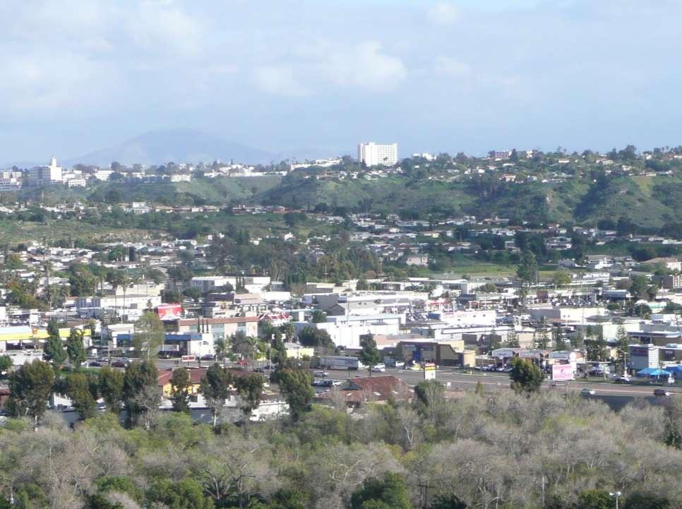
23 Alternative E/F Hybrid View from south of I-8* *View is 200 above the highest point in the Kensington/College neighborhood

24 Alternative E/F Hybrid View from south of I-8* *View is 200 above the highest point in the Kensington/College neighborhood

25 Alternative E/F Hybrid View from south of I-8* *View is 200 above the highest point in the Kensington/College neighborhood

26 Alternative E/F Hybrid from Santo Road in Tierrasanta

27 Alternative E/F Hybrid from Santo Road in Tierrasanta
28 Alternative G
29 Alternative G Existing Conditions Housing units: 0 du Commercial (includes office and retail): 1,334,115 sf Hospital: 722,510 sf Industrial: 1,289,518 Parks: 0 acres
30 Alternative G Existing Street Network
31 Alternative G Transportation New Street connection between Alvarado Canyon and Mission Gorge Place New Alvarado Canyon alignment Mission Gorge place connects to Fairmount with new bridge over San Diego River, Twain west of Fairmount goes away Street connections in Centerpointe (connect to Mission Gorge) Fairmount connection to Friars Road New streets north of Friars for residential development (could be private streets) Landscaped median and consolidated turn lanes in Mission Gorge Road
32 Alternative G Parks and Open Space 10 acre park north of Friars Road 6 acres of park north of Vandever at Fairmount intersection Two 1 acre parks west of Fairmount connecting to the San Diego River 1.8 acres of park along Alvarado Creek for bicycles and pedestrians 7.1 acre park near trolley station adjacent to Alvardo Creek 4.8 acre park near Navajo Canyon Park trailhead Approximately 31.7 acres of new park space Required population based park for 8,000 units is 43 acres
33 Alternative G Housing Residential uses adjacent to San Diego River north of Friars and West of Fairmount Residential uses at eastern end of Mission Gorge Place Residential uses throughout study area above commercial uses 8,000 total new housing units (most of which occur on mixed use blocks)
34 Alternative G Mixed Use High Density mixed use surrounding trolley station with large office and residential component mid to high rise Small scale mixed use along Mission Gorge Road and adjacent to Kaiser in Centerpointe blocks low to mid rise Mixed use Village Center on Twain low to mid rise A majority of the 8,000 total new housing units occur on these mixed use blocks
35 Alternative G Retail Village Center destination with retail and entertainment on new street between Mission Gorge and Fairmount south of Kaiser (Centerpoint blocks) Neighborhood retail on ground floor of mixed use building entire length of Mission Gorge Road and around trolley station 132,000 square feet of community oriented retail. 151,000 square feet of neighborhood retail
36 Alternative G Office Office along Mission Gorge Road north of Vandever and adjacent to Kaiser Hospital low to mid rise Office adjacent to Trolley station mid to high rise 370,000 square feet of office (including office uses in mixed use areas)
37 Alternative G Total New Development Yields Full build out of study area Housing units: 8,000 du (8M sf) Retail : 132,000 sf neighborhood Retail: 151,000 sf community Office: 370,000 sf Parks: 31.2 (43 required) Total Net Gain: 6,030,000 sf
38 Street Improvements Street Improvement Diagrams Street Sections
39 Street Improvement Concepts Mission Gorge Road Trolley Connection Mission Gorge Place Centerpointe Streets Fairmount Road Vandever

40 Mission Gorge Road Landscaped median Trees in grates Streetscape amenities

41 Mission Gorge Road Existing Landscaped section median Trees in grates Streetscape amenities Remove on-street parking

42 Mission Gorge Place New Connections New connection between Alvarado Canyon Road and Mission Gorge Place Alt A

43 Mission Gorge Place New Connections New connection between Alvarado Canyon Road and Mission Gorge Place Alt B

44 Mission Gorge Place New Connections Existing Connection Section between Alvarado Canyon and Mission Gorge Place

45 Twain Avenue Becomes a neighborhood village street

46 Twain Avenue Existing section Becomes a neighborhood village street

47 Fairmount Avenue New connection to Friars Road Diagonal connection to Riverdale intersection Alt A
48 Fairmount Avenue New connection to Friars Road Straight connection would require a bridge or bermed structure Alt B

49 Fairmount Avenue Existing Section New connection to Friars Road
50 Fairmount Avenue Improve connection between Mission Gorge Road and Twain with a new 4-way intersection at Mission Gorge Place remove Fairmount Mission Gorge intersection

51 Centerpointe Plan Connections between Fairmount Avenue and Mission Gorge Road Alt A

52 Village Center Connections between Fairmount Avenue and Mission Gorge Road Alt B
53 Village Center New streets between Fairmount and Mission Gorge and between Twain and Vandever

54 Vandever Avenue New public or private street west of Fairmount for park space connection to San Diego River

55 Vandever Avenue New Existing street Section west of Fairmount Avenue to San Diego River
56 Next Steps Land use Fine tune alternatives and determine land use intensities Economics ERA to test economic feasibility, estimate absorption, and assist with phasing Design Guidelines Begin guidelines and hold workshop at May 11 GSC Meeting Traffic Analysis Parks Parks staff to determine required park space May 11 GSC Meeting Community Plan Amendments
57
TRANSPORTATION REVIEW
 TRANSPORTATION REVIEW - PROPOSED MIX OF LAND USES IS CONSISTENT WITH THE CITY S UNDER THE GRANVILLE BRIDGE POLICIES THAT AIM TO MEET NEIGHBOURING RESIDENTS SHOPPING NEEDS AND REDUCE RELIANCE ON AUTOMOBILE
Garrett Hill Master Plan
 Garrett Hill Master Plan Visioning Workshop February 13, 2007 Campbell Thomas & Company Agenda Welcome Existing conditions summary Critical issues Visioning exercise Summary & next steps Critical Assets
METRO Orange Line BRT American Boulevard Station Options
 METRO Orange Line BRT American Boulevard Station Options Bloomington City Council Work Session November 18, 2013 Christina Morrison BRT/Small Starts Project Office Coordinating Planning and Design AMERICAN
APPENDIX VMT Evaluation
 APPENDIX 2.7-2 VMT Evaluation MEMORANDUM To: From: Mr. Jonathan Frankel New Urban West, Incorporated Chris Mendiara LLG, Engineers Date: May 19, 2017 LLG Ref: 3-16-2614 Subject: Villages VMT Evaluation
Location Concept Plan Amendment Recommendation Approved 2011 Concept Plan
 Valley Line West LRT Concept Plan Recommended Amendments Lewis Farms LRT Terminus Site Location Concept Plan Amendment Recommendation Approved 2011 Concept Plan Lewis Farms LRT terminus site, 87 Avenue/West
CORE AREA SPECIFIC PLAN
 only four (A, B, D, and F) extend past Eighth Street to the north, and only Richards Boulevard leaves the Core Area to the south. This street pattern, compounded by the fact that Richards Boulevard is
Metra Milwaukee District West Line Transit-Friendly Development Plan
 Metra Milwaukee District West Line Transit-Friendly Development Plan Community Input Workshop April 6, 2011 Overview of Presentation Workshop Goals Study Context Existing Conditions Market Overview Employment
TransNet Dollars Keep San Diego Moving
 TransNet Dollars Keep San Diego Moving In 1987, San Diego region voters approved the TransNet program a half-cent sales tax to fund a variety of important transportation projects throughout the region.
San Rafael Transit Center. Update. Golden Gate Bridge, Highway & Transportation District Transportation Committee of the Board of Directors
 Transportation Committee November 17, 2016 Agenda Item No. 5, Update on the San Rafael Transit Center Relocation San Rafael Transit Center Relocation Study Update 11/17/16 Golden Gate Bridge, Highway &
SOUTHERN GATEWAY. Transportation and Trinity River Project Committee 11 May 2015
 SOUTHERN GATEWAY Transportation and Trinity River Project Committee 11 May 2015 Southern Gateway Project History Began in 2001 as a Major Investment Study [ MIS ], Schematic, and Environmental Assessment
Attachment 5 Eglinton West LRT Planning and Technical Update
 Eglinton West LRT Planning and Technical Update 1. Introduction In July 2016, City Council approved an Eglinton West LRT with between 8 and 12 stops between Mount Dennis and Renforth Gateway, and up to
Qualcomm Stadium Redevelopment
 Qualcomm Stadium Redevelopment Executive Summary In May 2017, SANDAG s Service Bureau was asked by two separate entities 1 to forecast how proposed mixed-use development of the approximately 166-acre SDCCU
Orange Line Transit Neighborhood Planning Effort GOALS. mobility
 Transit Neighborhood ning Effort GOALS mobility walkability mix of uses public space jobs & housing ort h We ntw Gl t ds Transit Neighborhood ning Effort or f nd ks oa en CORRIDOR VISION a Bl Br vd Tampa
Downtown Community Plan Adopted April 2006
 Downtown Community Plan Adopted April 2006 Chapter 5.8 Goals and Policies: Sustainable Development Far Bonus Program: Eco-Roof Urban plazas, street activation and Neighborhood Centers Suburban vs. Urban
DOWNTOWN CONCORD SPECIFIC PLAN
 Timeline 21-month process Tasks 1-3; Basis for the preparation of the plan (Jan. through March) Tasks 4-5; Development and Evaluation of Alternatives. Selection of Preferred Alternative. Preparation of
4.1 Land Use. SECTION CONTENTS Land Use Transit Transportation Technology
 4 FUTURE CHANGES IN THE CORRIDOR Over the next 30 years, Santa Clara County will grow by roughly 637,000 residents and 303,500 jobs increases of 31 percent and 43 percent, respectively. 1 Changes in land
LEED v4 Building Design and Construction Quiz #3 LT
 LEED v4 Building Design and Construction Quiz #3 LT 1. How are walking and bicycling distance measured? A. Straight-line radius from a main building entrance B. Straight-line radius from any building entrance
CITY PLANNING COMMISSION AGENDA
 Page 7 CONSENT CALENDAR CITY PLANNING COMMISSION AGENDA ITEM NO: A STAFF: LONNA THELEN FILE NO: CPC CU 13-00008 QUASI-JUDICIAL PROJECT: APPLICANT: OWNER: 1710 DUBLIN PAULSON ARCHITECTS, P.C. MICHAEL W
Federal Way Link Extension
 Federal Way Link Extension Draft EIS Summary Route & station alternatives and impacts Link Light Rail System Map Lynnwood Mountlake Terrace Lynnwood Link Extension Shoreline 14th Northgate 40 Northgate
Challenges in a Post-Katrina Environment East-West Corridor Project Overview February, 2007
 EAST-WEST CORRIDOR Challenges in a Post-Katrina Environment East-West Corridor Project Overview February, 2007 Presentation Agenda Project Overview / Purpose and Need Highway Component Transit Component
US 81 Bypass of Chickasha Environmental Assessment Public Meeting
 US 81 Bypass of Chickasha Environmental Assessment Public Meeting March 14, 2013 Introductions ODOT FHWA SAIC Meeting Purpose Present need for bypass Provide responses to 10/04/11 public meeting comments
Escondido Marriott Hotel and Mixed-Use Condominium Project TRAFFIC IMPACT ANALYSIS REPORT
 Escondido Marriott Hotel and Mixed-Use Condominium Project TRAFFIC IMPACT ANALYSIS REPORT Prepared for Phelps Program Management 420 Sixth Avenue, Greeley, CO 80632 Prepared by 5050 Avenida Encinas, Suite
VIRGINIA RAILWAY EXPRESS MANASSAS PARK STATION PARKING EXPANSION. Site Evaluation & Recommendation. October 18, 2016
 MANASSAS PARK STATION PARKING EXPANSION Site Evaluation & Recommendation October 18, 2016 1 INFORMATION ITEM Project Overview Parking Demand Site Evaluation VRE Recommended Preferred Alternative Next Steps
Otay Ranch Station 2020 MOBILITY SERVICES MAP REGIONAL MOBILITY HUB IMPLEMENTATION STRATEGY
 MAGDALENA REGIONAL MOBILITY HUB IMPLEMENTATION STRATEGY Otay Ranch Station Mobility hubs are transportation centers located in smart growth areas served by high frequency transit service. They provide
Troost Corridor Transit Study
 Troost Corridor Transit Study May 23, 2007 Kansas City Area Transportation Authority Agenda Welcome Troost Corridor Planning Study Public participation What is MAX? Survey of Troost Riders Proposed Transit
Appendix A. Community Workshop Results PUBLIC REVIEW DRAFT
 Appendix A Community Workshop Results This Page Left Blank Intentionally Comprehensive Planning Community Workshop Summary July 30, 2012 The City of Becker invited the Community to participate in a Comprehensive
appendix 4: Parking Management Study, Phase II
 appendix 4: Parking Management Study, Phase II A4-1 A4-2 Eastlake Parking Management Study Final Phase 2 Report Future Parking Demand & Supply January 6, 2017 Submitted by Denver Corp Center III 7900 E.
Central City Line Locally Preferred Alternative (LPA) Amendment Public Hearing. July 24, 2014
 Amendment Public Hearing. July 24, 2014") Central City Line Locally Preferred Alternative (LPA) Amendment Public Hearing July 24, 2014 Project Description The Central City Line is a High Performance Transit project that will extend from Browne
Central City Line Locally Preferred Alternative (LPA) Amendment Public Hearing July 24, 2014 Project Description The Central City Line is a High Performance Transit project that will extend from Browne
PROJECT SCHEDULE. Plan for Implementation. Explore and Analyze. Refine Ideas. Identify Common Ideas SPRING 2016 SUMMER 2016 FALL 2016
 VISION WORKSHOP MAY 25 th 2016 A COLLABORATION PROJECT SCHEDULE Explore and Analyze Identify Common Ideas Refine Ideas Plan for Implementation SPRING 2016 SUMMER 2016 FALL 2016 TODAY S AGENDA Explore and
DOWNTOWN CONCORD SPECIFIC PLAN
 Timeline Next Milestones Alternatives Analysis Draft Report to MTC - July 30 Draft Specific Plan Outline July 31 First Draft Specific Plan Report September 15 Schedule and Agendas July 22 nd DSC #5 Evaluation
Community Advisory Committee. October 5, 2015
 Community Advisory Committee October 5, 2015 1 Today s Topics Hennepin County Community Works Update Project Ridership Estimates Technical Issue #4:Golden Valley Rd and Plymouth Ave Stations Technical
I-90 ALLSTON INTERCHANGE A MULTIMODAL TRANSPORTATION PROJECT PUBLIC INFORMATION MEETING
 I-90 ALLSTON INTERCHANGE A MULTIMODAL TRANSPORTATION PROJECT PUBLIC INFORMATION MEETING DECEMBER 8, 2015 JACKSON MANN COMMUNITY CENTER Meeting Agenda Welcome & Introductions Introduce Concept 3K West Station
Navigating in Different Rivers
 Navigating in Different Rivers Suburban TOD Julie Jones, Planning Manager, City of Fridley Julie Farnham, Senior Planner, City of Bloomington Kersten Elverum, Director of Planning & Development, City of
Jeff s House. Downtown Charlottesville. PEC Office
 Jeff s House Downtown Charlottesville PEC Office Year 2000 US Census Data Employed persons over 16 Percentage of Employed Persons Locality Avg Commute (in minutes) Drove Public Transit Walk/Bike Other
±25,934 SF C-3 ZONED PAD
 ±25,934 SF C-3 ZONED PAD SOUTH 5TH AVENUE, TUCSON, ARIZONA CONTACT US DAVE VOLK Vice President +1 520 323 5102 david.volk@cbre.com BRUCE SUPPES Vice President +1 520 323 5155 bruce.suppes@cbre.com PROPERTY
vision42
 vision42 www.vision42.org vision42 auto-free light rail boulevard for 42nd Street Roxanne Warren, AIA, Chair George Haikalis, ASCE, Co-Chair Institute for Rational Urban Mobility,Inc. www.vision42.org
COMMISSION WORKSHOP Tuesday, May 12, :00 a.m. 12:00 p.m.
 COMMISSION WORKSHOP Tuesday, 9:00 a.m. 12:00 p.m. AGENDA 1. Approval of the April 30, 2009 Workshop Minutes 2. Community Redevelopment Agency a. CRA Master Plan Update b. Downtown Parking Study 3. Economic
Parking Management Element
 Parking Management Element The State Transportation Planning Rule, adopted in 1991, requires that the Metropolitan Planning Organization (MPO) area implement, through its member jurisdictions, a parking
Green Line LRT: Beltline Recommendation Frequently Asked Questions
 Green Line LRT: Beltline Recommendation Frequently Asked Questions June 2017 Quick Facts Administration has evaluated several alignment options that would connect the Green Line in the Beltline to Victoria
Rapid Transit and Land-Use Integration a Reality
 City of Charlotte Rapid Transit and Land-Use Integration a Reality Transportation Oversight Committee Carolyn Flowers CEO Charlotte Area Transit System April 29, 2010 Charlotte Region Statistics Mecklenburg
Kendall Drive Premium Transit PD&E Study Project Kick-Off Meeting SR 94/Kendall Drive/SW 88 Street Project Development and Environment (PD&E) Study
 Study") Florida Department of Transportation District Six Kendall Drive Premium Transit PD&E Study Project Kick-Off Meeting SR 94/Kendall Drive/SW 88 Street Project Development and Environment (PD&E) Study What
Florida Department of Transportation District Six Kendall Drive Premium Transit PD&E Study Project Kick-Off Meeting SR 94/Kendall Drive/SW 88 Street Project Development and Environment (PD&E) Study What
Welcome. Green Line in Your Community
 Welcome Green Line in Your Community Today's session will provide you with information about Administration's recommendation for connecting the Green Line in the Beltline to Victoria Park and Inglewood/Ramsay
Transportation Sustainability Program
 Transportation Sustainability Program Photo: Sergio Ruiz A Comprehensive Approach to Growing Sustainably Public Investment and Strategies for Existing and Future Population Underway Transit capital and
Chevy Chase Lake. Preliminary Plan # B TRAFFIC STATEMENT. Prepared for: Chevy Chase Land Company & Bozzuto Development Company
 Chevy Chase Lake Preliminary Plan # 12002020B TRAFFIC STATEMENT Prepared for: Chevy Chase Land Company & Bozzuto Development Company Montgomery County, Maryland Prepared by: SSSTS Consulting (410) 718-8660
PORTLAND STREETCAR DEVELOPMENT ORIENTED TRANSIT
 PORTLAND STREETCAR DEVELOPMENT ORIENTED TRANSIT PREPARED BY THE OFFICE OF TRANSPORTATION AND PORTLAND STREETCAR, INC. PORTLAND, OREGON Sam Adams, City Commissioner Michael Powell, Board Chair April 2008
PUBLIC TRANSPORTATION
 PUBLIC TRANSPORTATION PROJECT TITLE U-MED DISTRICT MULTI-MODAL IMPROVEMENTS- PHASE II Transit Vehicles and Upgrades MUNICIPALITY OF ANCHORAGE Capital Improvement Program PROJECT LIST BY DEPARTMENT Public
PROJECT PRESENTATION NOBE II 14 JULY 2014
 PROJECT PRESENTATION NOBE II 14 JULY 2014 Map 8: Building Height Plan Map 10: Density and Height White Flint Sector Plan April 2010 Approved and Adopted 19 WHITE FLINT SECTOR PLAN - APRIL 2010 nobe ii
Alberta Aerotropolis Overview Booklet Prepared for the Leduc Partnership (City of Leduc & Leduc County)
") Alberta Aerotropolis Overview Booklet Prepared for the Leduc Partnership (City of Leduc & Leduc County) by MXD Development Strategists / Stantec June 2015 WHAT IS AN AEROTROPOLIS? An Aerotropolis is a
Alberta Aerotropolis Overview Booklet Prepared for the Leduc Partnership (City of Leduc & Leduc County) by MXD Development Strategists / Stantec June 2015 WHAT IS AN AEROTROPOLIS? An Aerotropolis is a
Station Evaluation. Durham-Orange Light Rail Transit Project Spring 2012
 Station Evaluation Durham-Orange Light Rail Transit Project Spring 2012 Key Ingredients for Station Development Platform Designs UNC Hospitals Station The UNC Hospitals Station Option D would be the westerly
3.6 Parking and Loading Conditions
 3.6 Parking and Loading Conditions This section presents vehicle parking and loading supply and demand conditions for the Geary corridor. The study area for this parking and loading analysis includes onstreet
Railyard Alternatives & I-280 Boulevard Feasibility Study 1 RAILYARD ALTERNATIVES & I-280 BOULEVARD (RAB) FEASIBILITY STUDY
 FEASIBILITY STUDY") Railyard Alternatives & I-280 Boulevard Feasibility Study 1 RAILYARD ALTERNATIVES & I-280 BOULEVARD (RAB) FEASIBILITY STUDY RAB Citizen Working Group Meeting, August 1 st 2016 CITIZEN WORKING GROUP (CWG)
Railyard Alternatives & I-280 Boulevard Feasibility Study 1 RAILYARD ALTERNATIVES & I-280 BOULEVARD (RAB) FEASIBILITY STUDY RAB Citizen Working Group Meeting, August 1 st 2016 CITIZEN WORKING GROUP (CWG)
SCAN Land Use and Transportation Committee Report June 10, 2015
 DRAFT DRAFT DRAFT Exhibit A to SCAN Minutes - June 10, 2015 SCAN Land Use and Transportation Committee Report June 10, 2015 Gaiety Hollow In April the Committee provided testimony in support of the Lord
TRAFFIC ENGINEERING ASSESSMENT MOUNT EDEN ROAD, MOUNT EDEN
 12 September 2017 Iain McManus Civitas Planning Consultants PO Box 47020 Ponsonby AUCKLAND 1144 Dear Iain, TRAFFIC ENGINEERING ASSESSMENT 43-45 45 MOUNT EDEN ROAD, MOUNT EDEN As requested, we have prepared
Restoration of Historic Streetcar Services in Downtown Los Angeles
 Restoration of Historic Streetcar Services in Downtown Los Angeles Alternatives Analysis Community Update Meeting August 2, 2011 Introduction Key players Local lead agency: Metro Federal lead agency: Federal
Brigham City 1200 West Box Elder Creek Bridge - Widening Project Type Reconstruction
 Brigham City 1200 West Box Elder Creek Bridge - Widening Project Type Reconstruction 550 North to 650 North $ 1,750,000 $ 1,582,113 To widen an existing bridge on 1200 West over Box Elder Creek that will
Green Line LRT: Beltline Segment Update April 19, 2017
 Green Line LRT: Beltline Segment Update April 19, 2017 Quick Facts On April 11, 2017, City Council approved Administration s recommendation for the Green Line to be underground in the Beltline from 2 Street
2.0 Development Driveways. Movin Out June 2017
 Movin Out June 2017 1.0 Introduction The proposed Movin Out development is a mixed use development in the northeast quadrant of the intersection of West Broadway and Fayette Avenue in the City of Madison.
August 2, 2010 Public Meeting
 Public Meeting LYMMO Expansion Alternatives Analysis Study Purpose of study is to provide a fresh look at potential LYMMO expansion, following Federal Transit Administration (FTA) Alternatives Analysis
The Eastern Connector Study November, 2007 planning for the future
 The Eastern Connector Study November, 2007 planning for the future In late 2006, Albemarle County and the City of Charlottesville jointly initiated the Eastern Connector Corridor Study. The Project Team
Midtown Corridor Alternatives Analysis. Policy Advisory Committee Meeting February 12, 2014
 Midtown Corridor Alternatives Analysis Policy Advisory Committee Meeting February 12, 2014 Today s Agenda Introductions Outreach efforts and survey results Other updates since last meeting Evaluation results
West Broadway Transit Study. Community Advisory Committee September 17, 2015
 West Broadway Transit Study Community Advisory Committee September 17, 2015 Introductions Community Engagement Summer Outreach Fall Outreach Technical Analysis Process Update Alternatives Review Economic
Craig Scheffler, P.E., PTOE HNTB North Carolina, P.C. HNTB Project File: Subject
 TECHNICAL MEMORANDUM To Kumar Neppalli Traffic Engineering Manager Town of Chapel Hill From Craig Scheffler, P.E., PTOE HNTB North Carolina, P.C. Cc HNTB Project File: 38435 Subject Obey Creek TIS 2022
Develop ground transportation improvements to make the Airport a multi-modal regional
 Project Overview TRANSPORTATION IMPROVEMENTS WHAT ARE THE PROJECT GOALS? Transportation transportation hub. Develop ground transportation improvements to make the Airport a multi-modal regional Land Use
Major Widening/New Roadway
 Revised Evaluation s Major Widening/New Roadway This page provides a summary of any revisions made to the draft scores presented at the October th Attributable Funds Committee meeting. The information
The South Waterfront District and the Portland Aerial Tram
 The South Waterfront District and the Portland Aerial Tram How infrastructure investment can catalyze redevelopment and remove barriers to healthy lifestyles Role of transportation infrastructure in creating
Purple Line Functional Master Plan Advisory Group (MPAG)
") Purple Line Functional Master Plan Advisory Group (MPAG) Tonight s Agenda Schedule Update MTA Additional Studies Comments On Functional Plan Format County Zoning Code Re-Write Takoma Langley Crossroads
Purple Line Functional Master Plan Advisory Group (MPAG) Tonight s Agenda Schedule Update MTA Additional Studies Comments On Functional Plan Format County Zoning Code Re-Write Takoma Langley Crossroads
Making Mobility Better, Together
 Making Mobility Better, Together Austin Transportation Department Gordon Derr, P.E., for Robert J. Spillar, P.E Director, Austin Transportation Department 1 AUSTIN TRANSPORTATION DEPARTMENT Our Mission
Welcome. Please Sign In
 Welcome South Bay Bus Rapid Transit (BRT) Draft Environmental Impact Report (DEIR) Public Meeting Please Sign In Please comment in any of the following manners: 1. Submit a comment form 2. Provide verbal
STH 60 Northern Reliever Route Feasibility Study Report
 #233087 v3 STH 60 Northern Reliever Route Feasibility Study Report Washington County Public Works Committee Meeting September 28, 2016 1 STH 60 Northern Reliever Route Feasibility Study Hartford Area Development
Fresno County. Sustainable Communities Strategy (SCS) Public Workshop
 Public Workshop") Fresno County Sustainable Communities Strategy (SCS) Public Workshop Project Background Senate Bill 375 Regional Transportation Plan (RTP) Greenhouse gas emission reduction through integrated transportation
Fresno County Sustainable Communities Strategy (SCS) Public Workshop Project Background Senate Bill 375 Regional Transportation Plan (RTP) Greenhouse gas emission reduction through integrated transportation
CITY OF DECATUR, TEXAS Development Services 1601 S. State Street Decatur, TX (940) voice (940) fax
 voice (940) fax") CITY OF DECATUR, TEXAS Development Services 1601 S. State Street Decatur, TX 76234 (940) 393-0250 voice (940) 626-4629 fax AGENDA Planning and Zoning Commission and City Council Joint Workshop* Monday,
CITY OF DECATUR, TEXAS Development Services 1601 S. State Street Decatur, TX 76234 (940) 393-0250 voice (940) 626-4629 fax AGENDA Planning and Zoning Commission and City Council Joint Workshop* Monday,
Executive Summary. Draft Environmental Impact Statement/Environmental Impact Report ES-1
 Executive Summary Introduction The Eastside Transit Corridor Phase 2 Project is a vital public transit infrastructure investment that would provide a transit connection to the existing Metro Gold Line
Charlotte-Mecklenburg Region Rapid Transit and Land-Use Integration
 Charlotte-Mecklenburg Region Rapid Transit and Land-Use Integration Legislative Committee on Urban Growth and Infrastructure Carolyn Flowers CEO Charlotte Area Transit System March 23, 2010 Charlotte Region
Waco Rapid Transit Corridor (RTC) Feasibility Study
 Feasibility Study") Waco Rapid Transit Corridor (RTC) Feasibility Study Chris Evilia, Director of Waco Metropolitan Planning Organization Allen Hunter, General Manager Waco Transit System Jimi Mitchell, Project Manager AECOM
Waco Rapid Transit Corridor (RTC) Feasibility Study Chris Evilia, Director of Waco Metropolitan Planning Organization Allen Hunter, General Manager Waco Transit System Jimi Mitchell, Project Manager AECOM
17.8 acres site 4.6 acres in floodplain & wetlands 3.5 acres of surface parking 9 acres of open space
 Peter Allen Associates, Inc. Nederveld, Inc. Ann Arbor/Grand Rapids Riverfront Village LLC 17.8 acres site 4.6 acres in floodplain & wetlands 3.5 acres of surface parking 9 acres of open space 17,000 Hospital
residents of data near walking. related to bicycling and Safety According available. available. 2.2 Land adopted by
 2. Assessment of Current Conditions and Needs In order to prepare a plan to reach the vision desired by the residents of Texarkana, it is first necessary to ascertain the current situation. Since there
11 October 12, 2011 Public Hearing APPLICANT:
 11 October 12, 2011 Public Hearing APPLICANT: CARING TRANSITIONS PROPERTY OWNER: HARDEE REALTY CORPORATION REQUEST: Conditional Use Permit (motor vehicle rental) STAFF PLANNER: Leslie Bonilla ADDRESS /
Citizens Committee for Facilities
 Citizens Committee for Facilities AGENDA Thursday, December 11, 2014 City Council Chambers 305 3 rd Avenue East -Twin Falls, Idaho 11:30 A.M. AGENDA ITEMS Purpose By 1. Discussion and possible action on
4 Circulation & Transportation
 4.1 Mobility Network The mobility network at the new St. Paul s hospital and health campus is comprised of an interconnected system of sidewalks, cycle paths, transit routes and roadways. Figure 4-1: Indicative
West Santa Ana Branch Transit Corridor. Informational Briefing Gateway Cities Service Council April 13, 2017
 West Santa Ana Branch Transit Corridor Informational Briefing Gateway Cities Service Council April 13, 2017 Project Study Area 98 square miles 20 individual cities plus unincorporated LA County 1.2 million
2.4 TRANSIT VISION 2040 FROM VISION TO ACTION. Support the revitalization of urban cores STRATEGIC DIRECTION
 TRANSIT VISION 2040 FROM VISION TO ACTION TRANSIT VISION 2040 defines a future in which public transit maximizes its contribution to quality of life with benefits that support a vibrant and equitable society,
Water Major Facilities
 Water Major Facilities Water Residential (Units per Acre) Water oversize Residential 2.0 or less $6,842 per unit All Areas except RT Ph 1,2 $1,342 per gross acre Residential 2.1 to 2.5 $6,842 per unit
THE WAY WE MOVE LRT FOR EVERYONE
 THE WAY WE MOVE LRT FOR EVERYONE 2 LRT for Everyone LRT FOR EVERYONE Light rail is about more than transit; it s about transforming Edmonton. As the city grows, so do its transportation needs. LRT is an
Technical Memorandum
 To: Copy: From: Wally Dubyk Jennifer Murray André Sponder/Christopher Gordon, P.Eng. Re: Southminster Church 1040 Bank Street Residential Development Parking Review Technical Memorandum Date: Project:
Subarea Study. Manning Avenue (CSAH 15) Corridor Management and Safety Improvement Project. Final Version 1. Washington County.
 Corridor Management and Safety Improvement Project. Final Version 1. Washington County.") Subarea Study Manning Avenue (CSAH 15) Corridor Management and Safety Improvement Project Final Version 1 Washington County June 12, 214 SRF No. 138141 Table of Contents Introduction... 1 Forecast Methodology
Subarea Study Manning Avenue (CSAH 15) Corridor Management and Safety Improvement Project Final Version 1 Washington County June 12, 214 SRF No. 138141 Table of Contents Introduction... 1 Forecast Methodology
This Evening s Agenda. Open House 7:00 7:30 Presentation 7:30 8:00 Community Feedback8:00 9:00 Adjourn
 This Evening s Agenda Open House 7:00 7:30 Presentation 7:30 8:00 Community Feedback8:00 9:00 Adjourn Preliminary Station Footprint Potential Mid-Peninsula High Speed Train Station Palo Alto Dominic Spaethling,
Appendix C. Parking Strategies
 Appendix C. Parking Strategies Bremerton Parking Study Introduction & Project Scope Community concerns regarding parking impacts in Downtown Bremerton and the surrounding residential areas have existed
Table 1: Existing Trip Generation A.M. Peak Hour P.M. Peak Hour Land Use ITE Code Intensity Daily Total In Out Total In Out
 October 24, 218 Mr. Justin D. Bridges, AIA, LEED AP Davidson A+E 431 Indian Creek Parkway Overland Park, KS 6627 RE: Dear Mr. Bridges, Trip Generation Overland Park, Kansas As requested, Priority Engineers,
Attachment 5. High Speed Transit Planning Study REPORT SUMMARY. Prepared by: City of Edmonton Transportation Planning Branch. Stantec Consulting Ltd.
 Attachment 5 High Speed Transit Planning Study Prepared by: City of Edmonton Transportation Planning Branch Stantec Consulting Ltd. Transportation Management & Design, Inc. with Lea Consulting Ltd. [135-35130]
Clearlake Road (State Road 501) Project Development & Environment (PD&E) Study
 Project Development & Environment (PD&E) Study") Clearlake Road (State Road 501) Project Development & Environment (PD&E) Study FROM MICHIGAN AVENUE TO INDUSTRY ROAD BREVARD COUNTY, FLORIDA Financial Project ID No: 433605-1-22-01 Federal Aid Project
Clearlake Road (State Road 501) Project Development & Environment (PD&E) Study FROM MICHIGAN AVENUE TO INDUSTRY ROAD BREVARD COUNTY, FLORIDA Financial Project ID No: 433605-1-22-01 Federal Aid Project
OFF-STREET PARKING REFORM IN MINNEAPOLIS AND ST. PAUL
 OFF-STREET PARKING REFORM IN MINNEAPOLIS AND ST. PAUL MINNESOTA APA October 1, 2014 Minneapolis Zoning Codes 1924 City s first zoning code 1963 City s second zoning code, which included the city s first
Northeast Corridor Alternatives Analysis. Public Involvement Round 2 Input on Alternatives for Further Study
 Northeast Corridor Alternatives Analysis Public Involvement Round 2 Input on Alternatives for Further Study Feb. 7-9, 2012 Agenda Review project background Progress summary Recommended alternatives for
The Brick Yard Buildings F & J Mid Atlantic Blvd. Laurel/Beltsville, Maryland. 10,000 to 122,136 SF
 The Brick Yard Buildings F & J Mid Atlantic Blvd. Laurel/Beltsville, Maryland 10,000 to 122,136 SF J I H G F E D A C Mid-Atlantic Blvd. B 200 The Brick Yard Rockville 95 Laurel Van Dusen Rd. Contee Rd.
Hennepin County Transit Oriented Development Program. The Ellipse, St. Louis Park, 2009
 Hennepin County Transit Oriented Development Program The Ellipse, St. Louis Park, 2009 What is Transit Oriented Development (TOD)? Development within walking distance of transit Typically ¼ to ½ mile 10
East Link Extension. September 16, Bel-Red Conclusion to Final Design Open House Public Involvement Summary
 East Link Extension September 16, 2014 Bel-Red Conclusion to Final Design Open House Public Involvement Summary Table of contents 1 Background 2 Overview 2 Notification 3 Open House Overview 4 Comment
CTA Blue Line Study Area
 CTA Blue Line Study Area HISTORY OF THE CTA BLUE LINE / I-290 SYSTEM Blue Line / I-290 infrastructure is 55 years old First integrated transit / highway facility in the U.S. PROJECT STUDY AREA EXISTING
Dixie Transportation Planning Office
 A project must be given a yes rating on items 1 & 2 in order to be prioritized. Sponsor: St. George City Project: Pioneer Parkway Type: Road Widening and Reconstruction Rev. 9/17/2010 Dixie Transportation
Chapter 7: Corridor Visions
 Chapter 7: Corridor Visions (see also Appendix 7 for Details) January 24, 2008 NOTE: This document has been prepared using Federal funding from the United States Department of Transportation. The United
West Broadway Reconstruction/LRT Design. March 19, 2015
 West Broadway Reconstruction/LRT Design March 19, 2015 1 Meeting Agenda 6:05 6:30 PM Brief presentation What we heard Project overview 6:30 8:00 PM Visit Six Topic Areas Road and LRT design elements Pedestrian
5 VAUGHAN METROPOLITAN CENTRE AND SURROUNDING AREAS TRANSPORTATION STUDY PROGRESS
 5 VAUGHAN METROPOLITAN CENTRE AND SURROUNDING AREAS TRANSPORTATION STUDY PROGRESS The Transportation Services Committee recommends the adoption of the recommendations contained in the following report