SPRINGWATER MISSING GAP Springwater Missing Gap Linking the Springwater on the Willamette Trail to the Springwater Corridor Trail June 2006
|
|
|
- Clare O’Neal’
- 5 years ago
- Views:
Transcription


1 Springwater Missing Gap Linking the Springwater on the Willamette Trail to the Springwater Corridor Trail June 2006
2 METRO COUNCIL David ragdon, President Rex urkholder Carl Hostica Susan McLain Robert Liberty rian Newman Rod Park METRO AUDITOR Alexis Dow, CPA METRO REGIONAL PARKS AND GREENSPACES DEPARTMENT Jim Desmond, Director Chris Carlson, Greenspaces Planning Manager Joel Morton, Office of Metro Attorney ALTA PLANNING + DESIGN George Hudson, Principal Karen Vitkay, Designer PROJECT MANAGER Mel Huie, Metro Regional Parks and Greenspaces Department For more information or copies of this report, contact: Mel Huie, Regional Trails Coordinator , huiem@metro.dst.or.us Metro Regional Services 600 NE Grand Ave. Portland, OR Alta Planning + Design 1638 NE Davis Portland, OR
3 TALE OF CONTENTS Executive Summary 1 Area Map 2 Section 1: SE Umatilla to SE Harney 3 Section 2: SE Harney to SE Clatsop 4 Section 3: SE Clatsop to SE Marion 5 Section 4: SE Marion to SE Linn 6 Section 5: SE Linn to SE 11th 7 Section 6: SE 11th to SE 13th 8 Section 7: SE 13th to Power Station 9 Section 8: Power Station to SE 16th 10 Section 9: SE 16th to SE 17th 11 Section 10: SE 17th to SE 19th 12 Intersection Figure 13 Typical Cross Sections 14 Appendix A: Cost Estimates 16 Recommended Alignment 17 Item Cost Sheet 21 Pole Summary 22
4 Executive Summary Presently, a gap exists between the Springwater on the Willamette Trail ending at SE Umatilla and the Three ridges portion of the Springwater Corridor Trail starting at SE 19th. The optimal alignment to connect the trail segments utilizes the same railroad corridor and provides a direct and seamless connection. A costalignment alternative was produced for the railroad corridor connection. The cost estimate does not include right-of-way acquisition costs or compensation for loss of future business due to the removal of sidings. Cost estimates for all intersections were developed by the Portland Office of Transportation PDOT. Recommended Alignment Green line on maps $3,090, The recommended alignment is a rail-with-trail shared-use 12 foot path on the southwest side of the mainline track from SE Umatilla to SE 13th. From SE Umatilla to SE Marion, the track is shifted to the northeast to provide space for the trail. At SE 13th, the alignment moves to the north of the mainline track for its duration. etween SE 13th and 17th, the railroad track and spur line are shifted to the south to accommodate the trail. etween SE 17th and SE 19th, the multi-use path is a 10 foot wide segment on the north side of SE Ochoco. The cost estimate does not include the sum necessary to acquire an easement through private property between 11th and 13th. Alternative Alignment Light green lines on map $3,084, An alternative is offered which incorporates trail deviations in order to minimize costs associated with moving power poles and easement acquisition. Deviations occur from SE Marion to 11th Street through Metro owned property and along 11th and Ochoco St. to avoid the acquisition of an easement on private property. In this scenario, no easement or property acquisition is required. 1


5 Springwater Missing Gap Study Area Linking the Springwater on the Willamette Trail to the Springwater Corridor Trail 2


6 Section 1: SE Umatilla to SE Harney LEGEND ManHoles UMATILLA AN 16'2 Relocate Pole Proposed Retaining Wall Existing RR Alignment 202 Sections Existing Conditions 10'0 RR shift Recommendations 6TH 291 Milliken Tower Alternative Trail Alignment Proposed RR Alignment 2'4 pole shift Electric Pole Proposed Trail Alignment D ES pump station GR 12'5 Track shift locator 2'1 min pole shift w 12' trail remove blackberries and shrubs 22'1 32'7 use fill to mitigate slope, need retaining wall ~4' Looking north from SE Umatilla 13'6 RR shift 8'11 2'1 min pole shift w 12' trail 17'6 relocate street signs 239 HARNEY 13' Feet Looking south from SE Umatilla

7 Section 2: SE Harney to SE Clatsop ail street signs LEGEND HARNEY 7TH 11 joint use private driveway: 36'0 to property fence Track shift locator Existing Conditions ManHoles Electric Pole Recommendations Milliken Tower Relocate Pole Proposed Retaining Wall Proposed Trail Alignment remove blackberries and shrubs Alternative Trail Alignment Proposed RR Alignment Existing RR Alignment 11'6 8'6 4'6 min pole shift w 12' trail Sections 11'6 RR shift 287 7'0 MH incorporate into trail SHERRETT 7'2 17'2 berm removal 8'10 ToS 8'8 max RR shift Looking north between SE Harney and SE Clatsop 17'1 76 9'11 5'11 min pole shift w 12' trail berm removal MARION 7'10 trail to err cl electrical box 14'0 1'10 min pole shift w 12' trail 78 Looking south between SE Harney and SE Clatsop 8'8 RR shift CLATSOP 0 7' Feet


8 Section 3: SE Clatsop to SE Marion 78 LEGEND Track shift locator ManHoles CLATSOP 7'4 Electric Pole Milliken Tower Relocate Pole Proposed Retaining Wall Proposed Trail Alignment Alternative Trail Alignment Proposed RR Alignment 9'1 19'4 erm removal Existing RR Alignment 8TH trail Sections Metro ond Property Existing Conditions 9'1 RR shift Recommendations 9'2 to toe of slope 7'5 trail cl 6'3 conflict with berm 7'3 RR shift 0 10'9 pole appears OK, must be 17'3 min from err, grading around pole needed Looking south from SE Clatsop MARION Feet Looking north from SE Marion 5


9 Section 4: SE Marion to SE Linn MARION 22'6 LEGEND Track shift locator ManHoles 88 2'0 min pole shift Electric Pole Milliken Tower Relocate Pole Proposed Retaining Wall Proposed Trail Alignment 9TH Alternative Trail Alignment Proposed RR Alignment Option 2: deviate trail & maintain pole locations. Existing RR Alignment Sections Metro ond Property Existing Conditions 22'10 Recommendations 94 too close to tower to move Uncontrolled intersection 22'0 LINN Install 4-way stop 2'6 min pole shift 92 Looking south from SE Marion Feet Looking north from SE Linn 6


10 Section 5: SE Linn to 11th LEGEND Uncontrolled intersection ManHoles Install 4-way stop Milliken Tower Relocate Pole Proposed Retaining Wall Alternative Trail Alignment Proposed RR Alignment Existing RR Alignment Sections Metro ond Property 2'3 min pole shift Existing Conditions '5 21'10 Option 2: deviate trail & maintain pole locations '8 min pole shift move RR sign to other side adjust catch basin 0 no field measurement assume 3' pole shift needed 10TH 2'8 min pole shift Recommendations 9'9 21'10 9TH Electric Pole Proposed Trail Alignment 11TH 22'3 LINN 130 Track shift locator trim vegetation 21'1 25'1 Looking southeast from SE Linn driveway 3'5 min pole shift Feet Looking northwest from SE 11th 7


11 Section 6: SE 11th to SE 13th sin LEGEND Track shift locator ManHoles 11TH approx 22'0 available by GIS for 14' trail 17'6 20'0 PRIVATE VACANT catch basin Electric Pole Milliken Tower Relocate Pole Proposed Retaining Wall Proposed Trail Alignment Alternative Trail Alignment Proposed RR Alignment Existing RR Alignment Sections '9 Existing Conditions Recommendations maintain min 8'6 bt trail edge & pole provide a break in RR tracks Option 2: deviate trail along street ROW. Metro ond Property 140 pole can not be moved, easement required 18'5 13'10 Train station rest stop 0 Looking southeast from SE 11th catch basin '0 OCHOCO RR shift beginning 125' west of 13th 13TH Pinch point: possible to acquire an easement? ~11'6 bt RR & prop line ~30'6 total available. Need additional 17' for 12' trail 11' min. 25'1 6 t Looking northwest from SE 13th Feet
12 Section 7: SE 13th to Power Station 13TH LEGEND ch in assume 12' existing bt rails, 14' proposed 65'6 from street to fence corner single track provides ample room for trail 11'0 from RR cl to fence catch basin maintain min 8' from retaining wall to trail cl 6'11 RR2 shift 12' separation ramping to 14' ~2.5' retaining wall for length of fence trail 3' from err cl 9'9 3'10 18'9 23'5 3'6 min pole shift 13'6 min RR shift 18'4 14'11 max RR shift to retain pole 6'6 max shift wo moving pole ~48'6 available 8'9 only gives 6'8 clearance begin RR split gr & re '5 0 Looking east from SE 13th 9 Relocate Pole Proposed Retaining Wall Proposed Trail Alignment Alternative Trail Alignment Proposed RR Alignment Existing Conditions Recommendations 6'10 max shift wo moving pole ~49' available 6'11 max RR shift wo moving pole ~49' available 9'10 max RR shift wo moving pole ~47' available Milliken Tower Sections 15'0 15'4 Electric Pole Existing RR Alignment Track shift locator ManHoles 4'6 spur shift min 8' from fence to trail cl 24' '10 tower shift north move pole 7'7 min 20'2 17'7 23'5 from green mark, ~27'10 from main RR cl Feet

13 2'3 tower shift north 12' trail with 6 buffers 26'2 il cl 16TH AVE n rom Remove 3 Miliken Towers & use as gateway features 15TH Section 8: Power Station to SE 16th Pinch point, 12' path with no shoulders provide ADA accessible ramp from neighborhood grading of berm & retaining wall required ft wo 15'4 7'4 max shift wo moving pole ~50' available 825' spur line length approx by GIS Electric Pole Milliken Tower Relocate Pole Proposed Retaining Wall Proposed Trail Alignment Alternative Trail Alignment Proposed RR Alignment Existing RR Alignment Sections Existing Conditions '10 Pinch point, 12' path with no shoulders Track shift locator ManHoles 3'9 tower shift north 12' trail with 6 buffers 25'1 LEGEND Recommendations 4'10 max RR shift wo moving pole ~50'6 available 15'1 5'4 max shift wo moving pole ~50' available 6'7 max RR shift wo moving pole ~50' available 6'10 max RR shift wo moving pole ~50'6 available Looking east from SE 15th Place 100 Feet Looking west from SE 15th Place 10

14 Section 9: SE 16th to SE 17th LEGEND 16TH AVE Track shift locator 28'3 from pole to toe of slope add ladder style crosswalks & caution signage 25'3 terminus of spur line 34'5 from pole to toe of slope provide ADA accessible ramp from neighborhood 8'6 min from tower 17TH ManHoles Alternative Trail Alignment Proposed RR Alignment 935 Recommendations '4 15'10 install pedestrian activated signal at intersection E W S 8'6 min from pole S T A N D R maintain 14'0 bt RR lines 0 Looking east from SE 16th Proposed Retaining Wall Existing Conditions 15'6 15'3 Relocate Pole Sections 1602 ~6'5 RR shift Milliken Tower Existing RR Alignment Electric Pole Proposed Trail Alignment 932 Looking west from SE 17th Feet


15 Section 10: SE 17th to SE 19th Track shift locator ManHoles Electric Pole Milliken Tower LEGEND Relocate Pole Proposed arrier Fencing Retaining Wall Proposed Trail Alignment Alternative Trail Alignment Proposed RR Alignment Existing RR Alignment Sections Existing Conditions Recommendations Looking east from SE 17th Looking west from SE 19th 12

16 SE Ochoco and SE 17th Intersection Improvements Figure 1: Improved intersection of SE Ochoco and SE 17th including: pedestrian activated signal, crossing arms, caution signs, ladder style crosswalks, shifting SE Ochoco and inclusion of a fence and remote control gated section of rail line. 13

17 Typical Section: Single Track Figure 2. Typical trail section: End fo spur line to SE 17th 14

18 Typical Section: Double Track 47-0 Figure 3. Typical trail section: Power station to end of spur line 15
19 Appendix A: Cost Estimates 16

20 17

21 18

22 19
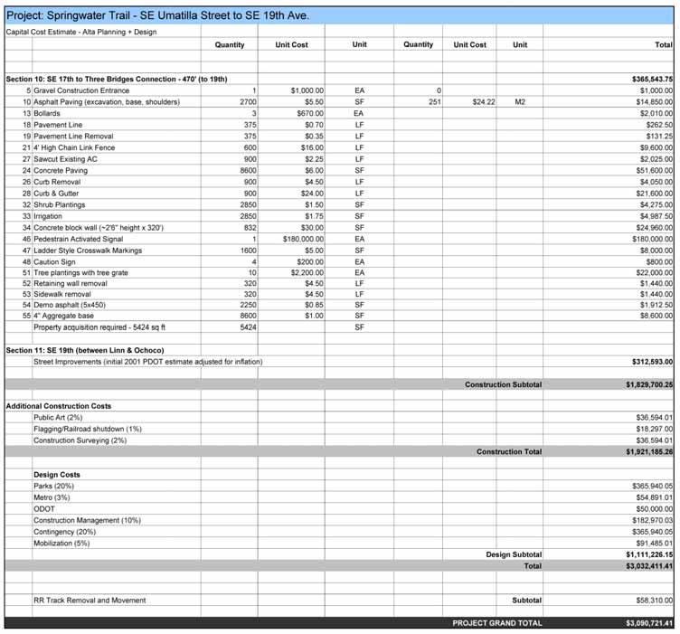
23 20

24 Summary of Individual Costs 21

25 Summary of Power Poles Note: Costs to relocate poles obtained from PGE 22
2.0 Development Driveways. Movin Out June 2017
 Movin Out June 2017 1.0 Introduction The proposed Movin Out development is a mixed use development in the northeast quadrant of the intersection of West Broadway and Fayette Avenue in the City of Madison.
South Lexington Transportation Study Lexington, Massachusetts
 South Lexington Transportation Study Lexington, Massachusetts Preliminary Findings and Options for Consideration Businesses Meeting 10/10/13 Town of Lexington Engineering and Planning Departments Meeting
APPENDIX C. Existing Utilities
 APPENDIX C Existing Utilities THIS PAGE INTENTIONALLY BLANK Existing Utilities Numerous utilities exist within the project area, including natural gas, sewer, water, electric, communications, and street
City of Houston Fondren Road Paving and Drainage
 City of Houston Fondren Road Paving and Drainage From Braeswood Boulevard to Creekbend Drive TRC Meeting March 2016 Location and Vicinity Maps City Council District K Key Map 530 Z, 530 Y Land Use Commercial
NORTHWEST HIGHWAY S-CURVE PEDESTRIAN/BICYCLE ACCESS FEASIBILITY STUDY. Northwest Highway (US 14) From Seegers Road to Western Avenue
 From Seegers Road to Western Avenue") NORTHWEST HIGHWAY SCURVE PEDESTRIAN/BICYCLE ACCESS FEASIBILITY STUDY Northwest Highway (US 14) From Seegers Road to Western Avenue Northwest Highway SCurve Pedestrian/Bicycle Access Feasibility Study City
NORTHWEST HIGHWAY SCURVE PEDESTRIAN/BICYCLE ACCESS FEASIBILITY STUDY Northwest Highway (US 14) From Seegers Road to Western Avenue Northwest Highway SCurve Pedestrian/Bicycle Access Feasibility Study City
Transportation Analysis. Pedestrian Pathways. Sterling District. County Project Manager: Suheili Pérez-Jiménez. Prepared by: J2 Engineers, Inc.
 Transportation Analysis Pedestrian Pathways Prepared for: Loudoun County Department of Transportation and Capital Infrastructure County Project Manager: Suheili Pérez-Jiménez Prepared by: J2 Engineers,
Section III Transportation and Stormwater Projects Receiving Additional Funding Project Detail Sheets Alphabetical Listing by Project Name Five Year
 Section III Transportation and Stormwater Projects Receiving Additional Funding Project Detail Sheets Alphabetical Listing by Project Name Five Year Capital Improvement Plan FY2015/2016 through FY2020
Stormwater and sanitary sewer lines 8 inches in diameter or greater
 3.8 UTILITIES 3.8.1 Affected Environment This section describes the utility crossings and utilities located in the vicinity of the Preferred Alternative. The utilities include electricity, communication,
5. HORIZON YEAR TRANSPORTATION MASTER PLAN-COST ESTIMATES
 5. HORIZON YEAR TRANSPORTATION MASTER PLAN-COST ESTIMATES 5.1 INTRODUCTION This chapter of the TMP presents an opinion of probable cost estimates for the proposed Horizon Year roadway network improvements
2016 PSRC REGIONAL & KING COUNTYWIDE EASTSIDE FUNDING AWARDS. Eastside Transportation Partnership September 9, 2016
 2016 PSRC REGIONAL & KING COUNTYWIDE EASTSIDE FUNDING AWARDS Eastside Transportation Partnership September 9, 2016 1 2 PSRC 2016 Project Selection Process 2018-2020 Estimated FHWA Funds Available: (Summary)
This letter summarizes our observations, anticipated traffic changes, and conclusions.
 Mr. David Jorschumb Project Manager Boulder Valley School District Re: Review of proposed school access improvements at the Foothills Elementary School in Boulder Dear Mr. Jorschumb, At your request, the
ACTION TRANSMITTAL No
 Transportation Advisory Board of the Metropolitan Council of the Twin Cities DATE: January 4, 2016 TO: ACTION TRANSMITTAL No. 2016-19 TAC Funding and Programming Committee PREPARED BY: Joe Barbeau, Senior
Bi-County Transitway/ Bethesda Station Access Demand Analysis
 Bi-County Transitway/ Bethesda Station Access Demand Analysis Prepared for: Washington Metropolitan Area Transit Authority Office of Planning and Project Development May 2005 Prepared by: in conjunction
CNG FUELING STATION INITIAL STUDY FULLERTON JOINT UNION HIGH SCHOOL DISTRICT. Appendices
 CNG FUELING STATION INITIAL STUDY FULLERTON JOINT UNION HIGH SCHOOL DISTRICT Appendices Appendix F Parking Study April 2016 CNG FUELING STATION INITIAL STUDY FULLERTON JOINT UNION HIGH SCHOOL DISTRICT
the importance of its role in local economic business operations that these business operations pursuant
 WHEREAS, City development; recognizes COUNCIL CHAMBER 27, 2018 importance its role in local economic WHEREAS, it is in interest City relocations economic vitality employment opportunities Dallas residents;
FEASIBILITY REPORT. 65 th STREET TRUNK WATER MAIN IMPROVEMENTS INVER GROVE HEIGHTS MINNESOTA DAKOTA COUNTY. October 2, 2017
 FEASIBILITY REPORT 65 th STREET TRUNK WATER MAIN IMPROVEMENTS INVER GROVE HEIGHTS MINNESOTA DAKOTA COUNTY October 2, 2017 Prepared for: City of Inver Grove Heights 8150 Barbara Avenue Inver Grove Heights,
Volume 1 Traffic Impact Analysis Turtle Creek Boulevard Dallas, Texas. Kimley-Horn and Associates, Inc. Dallas, Texas.
 Volume 1 Traffic Impact Analysis 2727 Dallas, Texas June 18, 2018 Kimley-Horn and Associates, Inc. Dallas, Texas Project #064523000 Registered Firm F-928 Traffic Impact Analysis 2727 Dallas, Texas Prepared
Highway 18 BNSF Railroad Overpass Feasibility Study Craighead County. Executive Summary
 Highway 18 BNSF Railroad Overpass Feasibility Study Craighead County Executive Summary October 2014 Highway 18 BNSF Railroad Overpass Feasibility Study Craighead County Executive Summary October 2014 Prepared
US 81 Bypass of Chickasha Environmental Assessment Public Meeting
 US 81 Bypass of Chickasha Environmental Assessment Public Meeting March 14, 2013 Introductions ODOT FHWA SAIC Meeting Purpose Present need for bypass Provide responses to 10/04/11 public meeting comments
IMPROVEMENT CONCEPTS
 IMPROVEMENT CONCEPTS for the South Novato Transit Hub Study Prepared by: January 11, 2010 DKS Associates With Wilbur Smith Associates IMPROVEMENT CONCEPTS Chapter 1: Introduction 1. INTRODUCTION The strategic
Midtown Corridor Alternatives Analysis Capital Cost Estimation Methodology and Assumptions
 Midtown Corridor Alternatives Analysis Capital Cost Estimation Methodology and Assumptions 1/3/2014 Prepared by the SRF Consulting Group Team for Table of Contents Introduction... 1 Alternatives Overview...
EXCEPTION TO STANDARDS REPORT
 EXCEPTION TO STANDARDS REPORT PROJECT DESCRIPTION AND NEED The project is located in Section 6, Township 23 North, Range 9 East and Section 31 Township 24 North, Range 9 East, in the Town of Stockton,
Harlem Avenue between 63 rd and 65 th
 Harlem Avenue between 63 rd and 65 th Community Advisory Group Meeting #3 December 1, 2017 Bedford Park Public Library 1 Meeting Agenda 1. Welcome/Introductions (3 mins) 2. Project Overview and Re-Cap
NAVY YARD BALLPARK STATION ACCESS IMPROVEMENTS STUDY. Final Report. Washington Metropolitan Area Transit Authority
 NAVY YARD BALLPARK STATION ACCESS IMPROVEMENTS STUDY Final Report Washington Metropolitan Area Transit Authority Office of Real Estate and Station Planning April 2016 [This page intentionally left blank]
Location Concept Plan Amendment Recommendation Approved 2011 Concept Plan
 Valley Line West LRT Concept Plan Recommended Amendments Lewis Farms LRT Terminus Site Location Concept Plan Amendment Recommendation Approved 2011 Concept Plan Lewis Farms LRT terminus site, 87 Avenue/West
Detailed Definition of Alternatives
 West Broadway Transit Study Detailed Definition of Alternatives 9/4/2015 DRAFT Prepared by the SRF Consulting Group Team for Table of Contents Introduction... 1 2040 No-Build Alternative... 1 Build Alternatives...
SOUTHERN GATEWAY. Transportation and Trinity River Project Committee 11 May 2015
 SOUTHERN GATEWAY Transportation and Trinity River Project Committee 11 May 2015 Southern Gateway Project History Began in 2001 as a Major Investment Study [ MIS ], Schematic, and Environmental Assessment
4 Circulation & Transportation
 4.1 Mobility Network The mobility network at the new St. Paul s hospital and health campus is comprised of an interconnected system of sidewalks, cycle paths, transit routes and roadways. Figure 4-1: Indicative
Project Description: Georgia Department of Transportation Public Information Open House Handout PI#(s): , County: Muscogee
: , County: Muscogee") Why We Are Here: GDOT s Transportation Improvement Act (TIA) Office, the City of Columbus, and the project delivery team are here this evening to display and answer questions concerning the proposed roadway
Why We Are Here: GDOT s Transportation Improvement Act (TIA) Office, the City of Columbus, and the project delivery team are here this evening to display and answer questions concerning the proposed roadway
DRAFT Design Study Report February 2015 Eagle River Traffic Mitigation Phase 1 MOA Project No Appendix D Utilities
 Appendix D Utilities This page intentionally left blank. Utilities There are numerous utilities present within the project area, including natural gas, sewer, water, electric, communications, and street
Chicago St. Louis High-Speed Rail. Braidwood Construction Public Meeting. August 7, 2014
 Chicago St. Louis High-Speed Rail Braidwood Construction Public Meeting August 7, 2014 1 Chicago-St. Louis Corridor Goals and Benefits» Reduction in travel time by about an hour» Enhanced reliability»
City of Lafayette Staff Report Circulation Commission
 City of Lafayette Staff Report Circulation Commission Meeting Date: September 5, 2016 Staff: Subject: James Hinkamp, Transportation Planner Consideration of a No Parking Zone on Victoria Avenue Summary
DRAFT TRANSPORTATION IMPACT STUDY CASTILIAN REDEVELOPMENT PROJECT
 DRAFT TRANSPORTATION IMPACT STUDY CASTILIAN REDEVELOPMENT PROJECT Prepared for: Submitted by: 299 Lava Ridge Ct. Suite 2 Roseville, CA. 95661 June 212 TABLE OF CONTENTS 1. Introduction... 1 Project Location
INDUSTRIAL DEVELOPMENT
 INDUSTRIAL DEVELOPMENT Traffic Impact Study Plainfield, Illinois August 2018 Prepared for: Seefried Industrial Properties, Inc. TABLE OF CONTENTS Executive Summary 2 Introduction 3 Existing Conditions
Traffic Impact Study Speedway Gas Station Redevelopment
 Traffic Impact Study Speedway Gas Station Redevelopment Warrenville, Illinois Prepared For: Prepared By: April 11, 2018 Table of Contents 1. Introduction... 1 2. Existing Conditions... 4 Site Location...
residents of data near walking. related to bicycling and Safety According available. available. 2.2 Land adopted by
 2. Assessment of Current Conditions and Needs In order to prepare a plan to reach the vision desired by the residents of Texarkana, it is first necessary to ascertain the current situation. Since there
Hudson-Bergen Light Rail Transit System Joint Occupancy-Joint Use
 Hudson-Bergen Light Rail Transit System Joint Occupancy-Joint Use Richard F. Hernon, New Jersey Transit Light rail systems share their rights-of-way with most other modes of ground transportation. The
Public Information Workshop
 Public Information Workshop Charlotte County-Punta Gorda MPO - Meeting Rooms A and B March 29, 2018 Welcome to the Public Information Workshop for Harborview Road Project Development and Environment (PD&E)
Brigham City 1200 West Box Elder Creek Bridge - Widening Project Type Reconstruction
 Brigham City 1200 West Box Elder Creek Bridge - Widening Project Type Reconstruction 550 North to 650 North $ 1,750,000 $ 1,582,113 To widen an existing bridge on 1200 West over Box Elder Creek that will
Chicago to St. Louis High-Speed Rail. IDOT District 8 Crossings. July 29, 2015
 Chicago to St. Louis High-Speed Rail IDOT District 8 Crossings July 29, 2015 1 History: Chicago-St. Louis Corridor» IDOT has actively developed the Chicago to St. Louis corridor since the mid 1980 s» In
CITY of NOVI CITY COUNCIL
 CITY of NOVI CITY COUNCIL Agenda Item 3 July 9, 2018 ci tyofnovi.org SUBJECT: Approval to award design engineering services to AECOM Great Lakes, Inc., for the Flint Street Realignment and Reconstruction
Station Evaluation. Durham-Orange Light Rail Transit Project Spring 2012
 Station Evaluation Durham-Orange Light Rail Transit Project Spring 2012 Key Ingredients for Station Development Platform Designs UNC Hospitals Station The UNC Hospitals Station Option D would be the westerly
Escondido Marriott Hotel and Mixed-Use Condominium Project TRAFFIC IMPACT ANALYSIS REPORT
 Escondido Marriott Hotel and Mixed-Use Condominium Project TRAFFIC IMPACT ANALYSIS REPORT Prepared for Phelps Program Management 420 Sixth Avenue, Greeley, CO 80632 Prepared by 5050 Avenida Encinas, Suite
Construction Realty Co.
 MEMORANDUM TO: FROM : Jeff Pickus Construction Realty Co. Luay R. Aboona, PE Principal 9575 West Higgins Road, Suite 400 Rosemont, Illinois 60018 p: 847-518-9990 f: 847-518-9987 DATE: May 22, 2014 SUBJECT:
Appendix F-1 Description of the Long-Term Alternatives
 Appendix F-1 Description of the Long-Term Alternatives Memorandum Page 1 of 21 Project No. 9309 Phase 280 Date June 2, 2015 From Chris Sidlar (LEA) To Edward Presta / City of Toronto C.C. Terry Wallace
Workshop Agenda. Bransford Roundabout. Bedford Intersection/Roundabout. Section 3 Revisions (Left turn lanes) Roadway Section/Curb Type Discussion
 Roadway Section/Curb Type Discussion") Workshop Agenda Bransford Roundabout Bedford Intersection/Roundabout Section 3 Revisions (Left turn lanes) Roadway Section/Curb Type Discussion Project Phasing Summary of Recommendation Purpose: Provide
Workshop Agenda Bransford Roundabout Bedford Intersection/Roundabout Section 3 Revisions (Left turn lanes) Roadway Section/Curb Type Discussion Project Phasing Summary of Recommendation Purpose: Provide
Lacey Gateway Residential Phase 1
 Lacey Gateway Residential Phase Transportation Impact Study April 23, 203 Prepared for: Gateway 850 LLC 5 Lake Bellevue Drive Suite 02 Bellevue, WA 98005 Prepared by: TENW Transportation Engineering West
June 27, WHEREAS, the City recognizes the importance of its role in local economic development; and
 COUNCIL CHAMBER 181001 June 27, 2018 WHEREAS, the City recognizes the importance its role local economic development; and WHEREAS, it is the terest the City Dallas to support and secure the expansions
Agenda Cover Memorandum
 Agenda Cover Memorandum Meeting Date: August 21, 2017 Meeting Type: COW (Committee of the Whole) City Council Budget Workshop Item Title: Final approval of an Ordinance amending various sections of Article
Technical Memorandum. To: From: Date: October 14 th, 2018 Project #: 1302 Project Name: Subject: Distribution:
 Technical Memorandum To: Tom Hanrahan Jeff Sharp From: Date: October 14 th, 2018 Project #: 1302 Project Name: Subject: Distribution: Barrie Lockhart Road LP Conformity Review Scott Young Sorbara Group
Interstate Operations Study: Fargo-Moorhead Metropolitan Area Simulation Results
 NDSU Dept #2880 PO Box 6050 Fargo, ND 58108-6050 Tel 701-231-8058 Fax 701-231-6265 www.ugpti.org www.atacenter.org Interstate Operations Study: Fargo-Moorhead Metropolitan Area 2025 Simulation Results
Mercer Island Center for the Arts Parking Management Plan
 Parking Stalls Mercer Island Center for the Arts Parking Management Plan June 15, 2016 This Parking Management Plan (P) covers all tenants at the Mercer Island Center for the Arts (MICA) campus, including
3.14 Parks and Community Facilities
 3.14 Parks and Community Facilities 3.14.1 Introduction This section identifies the park and community facility resources in the study area and examines the potential impacts that the proposed Expo Phase
PAPER FOR AREMA 2006 ANNUAL CONFERENCE LOS ANGELES UNION STATION RUN-THROUGH TRACKS UNION STATION TERMINAL IMPROVEMENTS. Paul Mak, PE, SE HDR Inc
 PAPER FOR AREMA 2006 ANNUAL CONFERENCE LOS ANGELES UNION STATION RUN-THROUGH TRACKS UNION STATION TERMINAL IMPROVEMENTS Paul Mak, PE, SE HDR Inc 801 S. Grand Ave. Suite 500, Los Angeles, CA 90017. Tel
Summary of the Alcoa Highway Redevelopment Project
 Appendix B Summary of the Alcoa Highway Redevelopment Project By Marcia Finfer, October 2009 The Timberlake community, along with numerous other concerned citizen groups (including the Lakemoor Hills community)
Table Existing Traffic Conditions for Arterial Segments along Construction Access Route. Daily
 5.8 TRAFFIC, ACCESS, AND CIRCULATION This section describes existing traffic conditions in the project area; summarizes applicable regulations; and analyzes the potential traffic, access, and circulation
Dixie Transportation Planning Office
 A project must be given a yes rating on items 1 & 2 in order to be prioritized. Sponsor: St. George City Project: Pioneer Parkway Type: Road Widening and Reconstruction Rev. 9/17/2010 Dixie Transportation
engineering phase and during the procurement of design build contracts.
 CONSIDERATION OF ALTERNATIVES Below-grade trench alignment along Aviation Boulevard, adjacent to LAX south runways. miles. MOS-Century would extend from the Metro Exposition Line to the Aviation/ Century
King Soopers #116 Thornton, Colorado
 Traffic Impact Study King Soopers #116 Thornton, Colorado Prepared for: Galloway & Company, Inc. T R A F F I C I M P A C T S T U D Y King Soopers #116 Thornton, Colorado Prepared for Galloway & Company
Study Area and Location District PSA Ward ANC Phase Description A Proposed Monroe Street Northeast Eastbound at Rhode Island Avenue
 Speed Limit and Safety Nexus Studies for Automated Enforcement Locations in the District of Columbia Monroe Street NE and Rhode Island Avenue NE Study Area and Location District PSA Ward ANC Phase Description
UBC Watermain as shown on Sheet 202 : Sub total 97,050
 Preliminary Cost Estimate Brock Commons Phase 1 Watermain replacement UBC Portion of Works only Replace existing 150mm dia CI and 200mm dia AC watermain with 200mm & 250mm dia DI (ductile iron) watermain
Validation Study. Proposed Railroad Grade Separation Algonquin Road at the Union Pacific Milwaukee Railroad. May 15, 2008.
 Validation Study Proposed Railroad Grade Separation Algonquin Road at the Union Pacific Milwaukee Railroad May 15, 2008 Prepared for: City of Des Plaines Des Plaines Civic Center 1420 Miner Street Des
WELCOME PUBLIC OPEN HOUSE FOR US-64 FROM THE SH-18 INTERSECTION EAST 6.5 MILES JANUARY 10TH, 2017 PAWNEE CITY HALL, 5:30 PM
 WELCOME PUBLIC OPEN HOUSE FOR US-64 FROM THE SH-18 INTERSECTION EAST 6.5 MILES JANUARY 10TH, 2017 PAWNEE CITY HALL, 5:30 PM 1 PURPOSE OF THIS OPEN HOUSE Present information about the proposed improvements
Challenges in a Post-Katrina Environment East-West Corridor Project Overview February, 2007
 EAST-WEST CORRIDOR Challenges in a Post-Katrina Environment East-West Corridor Project Overview February, 2007 Presentation Agenda Project Overview / Purpose and Need Highway Component Transit Component
Regional Transportation System The regional transportation system is discussed in Chapter 5, Section 5.7.
 6.7 TRAFFIC 6.7.1 Affected Environment Regional Transportation System The regional transportation system is discussed in Chapter 5, Section 5.7. Local Transportation System The proposed Dillingham Trail
Report Date: May 18, 2012 Contact: Al Zacharias Contact No.: RTS No.: 9587 VanRIMS No.: Meeting Date: June 12, 2012
 A5 ADMINISTRATIVE REPORT Report Date: May 18, 2012 Contact: Al Zacharias Contact No.: 604.873.7214 RTS No.: 9587 VanRIMS No.: 08-2000-21 Meeting Date: June 12, 2012 TO: FROM: SUBJECT: Vancouver City Council
CROSSING RAIL PROJECT (P4) RAIL
 RAIL") GRAND CROSSING RAIL PROJECT (P4) Community Advisory Group October 10, 2012 1:30 pm Grand Crossing Park Field House 7655 S. Ingleside Avenue, Chicago GRAND CROSSING RAIL PROJECT (P4) Community Advisory
GRAND CROSSING RAIL PROJECT (P4) Community Advisory Group October 10, 2012 1:30 pm Grand Crossing Park Field House 7655 S. Ingleside Avenue, Chicago GRAND CROSSING RAIL PROJECT (P4) Community Advisory
Environmental Assessment Derry Road and Argentia Road Intersection
 Air and Noise Study Environmental Assessment Derry Road and Argentia Road Intersection Project 11-4295 City of Mississauga, Region of Peel October 17, 2014 1 Region of Peel Environmental Assessment for
Traffic Impact Analysis. Alliance Cole Avenue Residential Site Dallas, Texas. Kimley-Horn and Associates, Inc. Dallas, Texas.
 Traffic Impact Analysis Alliance Cole Avenue Residential Site Dallas, Texas February 15, 2018 Kimley-Horn and Associates, Inc. Dallas, Texas Project #064524900 Registered Firm F-928 Traffic Impact Analysis
Traffic Engineering Study
 Traffic Engineering Study Bellaire Boulevard Prepared For: International Management District Technical Services, Inc. Texas Registered Engineering Firm F-3580 November 2009 Executive Summary has been requested
The Design-Builder shall meet local road criteria provided by the local governing agencies.
 11 ROADWAYS 11.1 General The -Builder shall conduct all Work necessary to meet the requirements of roadways. Roadway classifications include mainline, acceleration lanes, deceleration lanes, auxiliary
Open House. Highway212. Meetings. Corridor Access Management, Safety & Phasing Plan. 5:30 to 6:30 p.m. - Southwest Corridor Transportation Coalition
 Welcome Meetings 5:30 to 6:30 p.m. - Southwest Corridor Transportation Coalition 6:30 to 8:00 p.m. - Open House Why is Highway 212 Project Important? Important Arterial Route Local Support Highway 212
Engineering Report: Shasta-Trinity National Forest. South Fork Management Unit. Analysis of. National Forest System Road 30N44
 Engineering Report: Shasta-Trinity National Forest South Fork Management Unit Analysis of National Forest System Road 30N44 (milepost 0.00 to 0.40) for Motorized Mixed Use Designation Forest: Shasta-Trinity
Study Area and Location District PSA Ward ANC Phase Description C Planned Suitland Parkway Westbound at Stanton Road Southeast
 Speed Limit and Safety Nexus Studies for Automated Enforcement Locations in the District of Columbia Suitland Parkway at Stanton Road SE Study Area and Location District PSA Ward ANC Phase Description
SKIFFES CREEK SPECIAL USE PERMIT AND REZONING APPLICATION
 SKIFFES CREEK SPECIAL USE PERMIT AND REZONING APPLICATION Background 1. The Property Virginia Electric and Power Company ( Dominion Virginia Power or the Company ) owns three parcels of land north of Route
Pace Bus Depot Location Analysis
 Pace Bus Depot Location Analysis Key Notes 1. Options refer to conceptual sketches prepared by Kimley Horn. 2. The depot is assumed to accommodate Pace routes as they currently exist: 17 routes on the
Regional Transportation System The regional transportation system is discussed in Chapter 5, Section 5.7.
 6.7 TRAFFIC 6.7.1 Affected Environment Regional Transportation System The regional transportation system is discussed in Chapter 5, Section 5.7. Local Transportation System The proposed Dillingham Trail
TABLE 4-4 DAILY LRT ALTERNATIVE STATION PASSENGER VOLUMES IN 2030
 Station Volumes and Boardings/Alightings The stations proposed for the LRT Alternative were selected due to their proximity to population and employment centers, major existing transportation facilities,
ROAD SAFETY AUDIT. Salem Road at South Street. Town of Tewksbury. October 3, Prepared For: Massachusetts Department of Transportation
 ROAD SAFETY AUDIT Salem Road at South Street Town of Tewksbury October 3, 2016 Prepared For: Massachusetts Department of Transportation Town of Tewksbury, Massachusetts Prepared By: TEC, Inc. 65 Glenn
Letter EL652 City of Mercer Island. Page 1. No comments n/a
 Letter EL652 City of Mercer Island Page 1 No comments n/a Page 2 Response to comment EL652 1 Section 4.5.3 of the Final EIS presents the range of potential impacts of the project. This project also lists
TECHNICAL MEMORANDUM. Part A: Introduction
 TECHNICAL MEMORANDUM To: David J. Decker Decker Properties, Inc. 5950 Seminole Centre Ct. Suite 200 Madison, Wisconsin 53711 608-663-1218 Fax: 608-663-1226 www.klengineering.com From: Mike Scarmon, P.E.,
Extending TRACKS. Preliminary design plan review underway. Public comment and approval process in May & June. Municipal Consent Process
 Extending TRACKS Issue 5 Spring 2014 Preliminary design plan review underway Public comment and approval process in May & June Residents and businesses along the Southwest LRT (METRO Green Line Extension)
Project Status Update January 2017
 Project Status Update January 2017 1 What is the Purple Line? A new 16 mile east-west light rail line Operates mostly on the surface with 21 stations Connects New Carrollton in Prince George s County and
TRAFFIC MANAGEMENT STANDARDS CITY OF GARLAND TRANSPORTATION DEPARTMENT
 TRAFFIC MANAGEMENT STANDARDS CITY OF GARLAND TRANSPORTATION DEPARTMENT JUNE 1996 TABLE OF CONTENTS 1.0 Street Design Standards 1.1 Right-of-Way Requirements 1.2 Median Openings 1.3 Sidewalks 1.4 Traffic
BOARD OF SUPERVISORS BUSINESS MEETING ACTION ITEM. Design Endorsement for Sterling Boulevard Extension
 Date of Meeting: July 20, 2017 # 6 BOARD OF SUPERVISORS BUSINESS MEETING ACTION ITEM SUBJECT: ELECTION DISTRICT: CRITICAL ACTION DATE: STAFF CONTACTS: Design Endorsement for Sterling Boulevard Extension
Elbert County 500 MW Generation Addition Interconnection Feasibility Study Report OASIS POSTING # GI
 Executive Summary Elbert County 500 MW Generation Addition Interconnection Feasibility Study Report OASIS POSTING # GI-2003-2 Xcel Energy Transmission Planning January 2004 This Interconnection Feasibility
Welcome The City has undertaken a naming exercise for the existing and future LRT lines. The SE to West LRT, as the project has been called to date,
 Welcome The City has undertaken a naming exercise for the existing and future LRT lines. The SE to West LRT, as the project has been called to date, is now called the Valley Line. We are here to present
June WASHINGTON STATE DEPARTMENT OF TRANSPORTATION Alaskan Way Viaduct and Seawall Replacement Program Seattle, Washington
 DESIGN DEVIATION NOs. 1 & 2 Horizontal Stopping Sight Distance and Shoulder Width Reduction SR 99 S. Holgate St to S. King St. Viaduct Replacement Stage 2 MP 29.89 TO MP 30.78 XL-3237 PIN-809936D June
TABLE OF CONTENTS FIGURES: MAP EXHIBITS: TABLES:
 TransWest Express Transmission Project TABLE OF CONTENTS 7.0 DESIGN OPTIONS... 7-1 7.1 OVERVIEW OF DESIGN OPTIONS... 7-1 7.2 DESIGN OPTIONS PURPOSE AND NEED AND DESIGN CHARACTERISTICS... 7-4 7.2.1 Design
Brent Spence Bridge Design Exceptions - Alternative I
 s - Alternative I ITERCHAGE umber Existing Reason(s) For Potential Impact(s) to Eliminate s Potential Mitigation Solutions CURVE O. 5 PI Sta. 24+98.87 Y 1 57 mph (60) 526' (570') 44 mph The line of sight
WARES. October, 2018
 WARES October, 2018 1 Project Overview A new 16 mile east-west light rail line between Bethesda in Montgomery County and New Carrollton in Prince George s County Operates mostly on the surface with 21
2 EXISTING ROUTE STRUCTURE AND SERVICE LEVELS
 2 EXISTING ROUTE STRUCTURE AND SERVICE LEVELS In the Study Area, as in most of the Metro Transit network, there are two distinct route structures. The base service structure operates all day and the peak
Aurora Line/I-225 Rail Project Update Public Meeting. June 4, 2014
 Aurora Line/I-225 Rail Project Update Public Meeting June 4, 2014 FasTracks and I-225 Rail Line Update Danielle Smith I-225 Rail Line Design/Build Coordination Manager 2 The RTD FasTracks Plan 122 miles
Business Advisory Committee. July 7, 2015
 Business Advisory Committee July 7, 2015 1 Today s Topics Outreach Update TI #1 and 2: Target Field Station Connection to I-94: Recommendation 85 th Station Configuration 93 rd Station Configuration DEIS
Figure 1 Map of intersection of SR 44 (Ravenna Rd) and Butternut Rd
 and Butternut Rd") Abbreviated Study District: 12 County: Geauga Route: SR 44 Section: 1.58 GEA 44 1.58 213 HSP # 47 (Rural Intersection) Prepared April 23, 215 By Bryan Emery Existing Conditions This study contains the
Abbreviated Study District: 12 County: Geauga Route: SR 44 Section: 1.58 GEA 44 1.58 213 HSP # 47 (Rural Intersection) Prepared April 23, 215 By Bryan Emery Existing Conditions This study contains the
Current Corridor Characteristics. MN 62 Corridor Performance
 Corridor Context The corridor runs 12 miles between I-494 and MN 55 south of Minneapolis. The corridor serves as an important East-West connection for the Metro area. A portion of the corridor has been
Traffic Impact Analysis West Street Garden Plots Improvements and DuPage River Park Garden Plots Development Naperville, Illinois
 Traffic Impact Analysis West Street Garden Plots Improvements and DuPage River Park Garden Plots Development Naperville, Illinois Submitted by April 9, 2009 Introduction Kenig, Lindgren, O Hara, Aboona,
Purpose of Tonight s Meeting
 Purpose of Tonight s Meeting Point Dume Neighborhood Traffic Calming Project background, goals Resident Safety Concerns Existing Conditions Fact Sheets Map of Proposed Improvements Discussion Next Steps
FREQUENTLY ASKED QUESTIONS
 THE PROJECT Last updated on 2/19/16 FREQUENTLY ASKED QUESTIONS What s happening on Highway 169? The Minnesota Department of Transportation (MnDOT) is planning to rebuild and repair the infrastructure on
Calgary Transit and the Calgary Transportation Plan Chris Jordan, M.Sc., P.Eng. Coordinator, Strategic Transit Planning, Calgary Transit
 Calgary Transit and the Calgary Transportation Plan Chris Jordan, M.Sc., P.Eng. Coordinator, Strategic Transit Planning, Calgary Transit 1. Plan It Calgary the new Municipal Development Plan and Calgary