LAND FOR SALE. LIVE OAK RAILROAD RAIL SPUR 10 Acres & 1 Mile of Track East Basse Road, Suite 100 San Antonio, TX
|
|
|
- Vernon Harmon
- 5 years ago
- Views:
Transcription

 Close proximity to all Eagle Ford activities everal other energy related businesses in the Park ALE PRICE:")
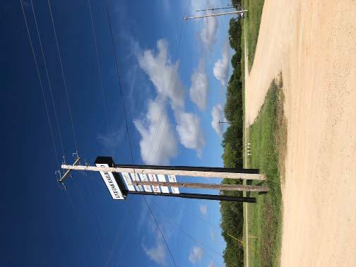
1 LAND FOR ALE RAIL PUR 10 Acres & 1 Mile of Track Three Rivers IH-37 Your ign Here George West 10 acre site including 1 mile of track Dedicated Union Pacific ervice Guaranteed daily service from an Antonio to Houston Easy access to IH-37 Includes switch, track, and all weather surfacing (including road) Frontage on U 281 with signage Located within a master planned rail park (Live Oak Railroad) Close proximity to all Eagle Ford activities everal other energy related businesses in the Park ALE PRICE: $1,810,000, IOR
2 N 00 34'06" W ' N CALE: 1" = 300' 0' 150' 300' ITE (N 80 19'13" E) N 80 20'56" E 96.83' 1 2" CAPPED IRON ROD FOUND TAMPED "KFW" C.M. 40' ROAD RIGHT-OF-WAY PER 29/233 D.R.L.C.T. LIVE OAK RAIL OPERATION. LLC VOLUME 241 PAGE 962 CALLED ACRE 1 2" CAPPED IRON ROD FOUND TAMPED "KFW" C.M. 40' ROAD RIGHT-OF-WAY PER 29/233 D.R.L.C.T ' VICINITY MAP NOT TO CALE ACRE OF LAND ETH CAREY URVEY NUMBER 36, ABTRACT NUMBER 136 & MICHAEL CRONICAN URVEY NUMBER 35, ABTRACT NUMBER 135, LIVE OAK COUNTY, TEXA Field notes to all that certain tract or parcel of land situated in the eth Carey urvey Number 36, Abstract Number 136, and the Michael Cronican urvey Number 35, Abstract Number 135, Live Oak County, Texas, being a part of a called acre tract of land described in the deed from Cuatro Paisanas Ranch, Inc. to LOLC, LLC recorded in Volume 241, Page 973, of the Official Public Records of Live Oak County, Texas, and being a part of Tract 19,20, 21, 27, 47, and 48 of Kittie Block ubdivision recorded in Volume 29, Page 233, of the Deed Records of Live Oak County, Texas the subject tract being more particularly described as follows: ACRE A PART OF A CALLED ACRE VOL. 241, PG. 973, & A PART OF TRACT 19, 20, 21, 27, 47, AND 48 KITTIE BLOCK UBDIVIION VOL. 29, PG. 233, D.R.L.C.T '06" E ' BEGINNING at 1/2-Inch red plastic capped iron rod stamped TOPOGRAPHIC set for the Northwest corner, same being in the North line of said acre tract of land, and in the outh right of way line of gravel road under apparent public use with no name posted, referenced as County Road Number 313 per Volume 241, Page 973, of the Official Public Records of Live Oak County, Texas, a called Forty (40') foot right of way per Volume 29, Page 233, of the Deed Records of Live Oak County, Texas, from which a 1/2-Inch blue plastic capped iron rod stamped KFW found the Northwest corner of said acre tract of land bears outh 80 20'56" West a distance of feet; THENCE North 80 20'56" East with the North line of said acre tract of land and said outh right of way line a distance of feet to a 1/2-Inch red plastic capped iron rod stamped TOPOGRAPHIC set for the Northeast corner, from which a 1/2-Inch blue plastic capped iron rod stamped KFW found for the Northeast corner of said acre tract of land, same being the Northwest corner of a called acre tract of land described in the deed from Cuatro Paisanas Ranch, Inc. to Live Oak Rail Operations, LLC recorded in Volume 241, Page 962, of the Official Public Records of Live Oak County, Texas bears North 80 20'56" East a distance of feet; LOLC, LLC VOLUME 241 PAGE 973 CALLED ACRE THENCE outh 00 34'06" East with the East line of the herein described tract of land a distance of feet to a 1/2-Inch red plastic capped iron rod stamped TOPOGRAPHIC set for corner at the beginning of a tangent curve to the left having a radius of feet, a delta angle of 13 08'56", a chord bearing of outh 07 08'34" East, and a chord length of feet; THENCE outherly with the East line of the herein described tract of land, and with said curve to the left an arc distance of feet to a 1/2-Inch red plastic capped iron rod stamped TOPOGRAPHIC set for corner at the point of tangency of said curve; THENCE outh 13 43'02" East with the East line of the herein described tract of land a distance of feet to a 1/2-Inch red plastic capped iron rod stamped TOPOGRAPHIC set for corner at the beginning of a non-tangent curve to the left having a radius of feet, a delta angle of 09 20'00", a chord bearing of outh 42 51'18" East, and a chord length of feet; THENCE outheast with the East line of the herein described tract of land, and with said curve to the left an arc distance of feet to a 1/2-Inch red plastic capped iron rod stamped TOPOGRAPHIC set for corner at the end of said curve; 300.0' THENCE outh 47 31'18" East with the East line of the herein described tract of land a distance of feet to a 1/2-Inch red plastic capped iron rod stamped TOPOGRAPHIC set for outheast corner, same being in the outh line of said acre tract of land and a Westerly North line of said acre tract of land; ARC LENGTH: ' RADIU: ' DELTA ANGLE: 11 30'18" ARC LENGTH: ' RADIU: ' DELTA ANGLE: 13 08'56" THENCE North 53 52'53" West with the outh line of said acre tract of land and the Westerly North line of said acre tract of land a distance of feet to a 1/2-Inch red plastic capped iron rod stamped TOPOGRAPHIC set for the outhwest corner, from which a 1/2-Inch blue plastic capped iron rod stamped KFW found an interior ell corner of said acre tract of land, same being a corner of said acre tract of land bears North 53 52'53" West a distance of feet; THENCE North 13 43'02" West with the West line of the herein described tract of land a distance of feet to a 1/2-Inch red plastic capped iron rod stamped TOPOGRAPHIC set for corner at the beginning of a non tangent curve to the right having a radius of feet, a delta angle of 11 30'18", a chord bearing of North 07 53'16" West, and a chord length of feet; THENCE Northerly with the West line of the herein described tract of land and said curve to the right an arc distance of feet to a 1/2-Inch red plastic capped iron rod stamped TOPOGRAPHIC set for corner at the point of tangency of said curve; THENCE North 00 34'06" West with the West line of the herein described tract of land a distance of feet to the POINT OF BEGINNING and enclosing acres of land more or less. 1 2" CAPPED IRON ROD FOUND TAMPED "KFW" 13 43'02" E ' NOTE: ORIGINAL DOCUMENT IZE: 18" X 24" THE BEARING AND COORDINATE VALUE CONTAINED HEREIN ARE "GRID" AND BAED UPON THE TEXA TATE PLANE COORDINATE YTEM, TEXA OUTH CENTRAL ZONE, NORTH AMERICAN DATUM 1983 U.. URVEY FOOT, ALL DITANCE ARE GRID AND MAY BE DIVIDED BY A COMBINED CALE FACTOR OF TO CALCULATE URFACE DITANCE. ALL AREA HOWN HEREON ARE URFACE AND MAY BE MULTIPLIED BY THE QUARE OF THE COMBINED CALE FACTOR OF TO CALCULATE GRID AREA. LIVE OAK RAIL OPERATION. LLC VOLUME 241 PAGE 962 CALLED ACRE ABTRACT 136 ETH CAREY URVEY NO. 36 ABTRACT 135 MICHAEL CRONICAN URVEY NO. 35 N 13 43'02" W ' (N 53 52'53" W) N 53 52'53" W ' 300.0' ARC LENGTH: 99.74' RADIU: ' DELTA ANGLE: 09 20'00" 47 31'18" E ' P.O.B. = POINT OF BEGINNING D.R.L.C.T. = DEED RECORD, LIVE OAK COUNTY, TEXA = OFFICIAL PUBLIC RECORD, LIVE OAK COUNTY, TEXA = 1/2-INCH CAPPED IRON ROD TAMPED "TOPOGRAPHIC" ET. THI URVEY WA PERFORMED WITHOUT THE BENEFIT OF A CHEDULE A & B OR CURRENT TITLE BINDER. NOT ALL IMPROVEMENT LOCATED OR HOWN ON URVEY. ONLY THE EAEMENT OF RECORD UPPLIED TO ME BY HAVE BEEN ADDREED IN THI URVEY. THERE MAY BE OTHER EAEMENT OF RECORD THAT AFFECT THE UBJECT TRACT. ADJOINER INFORMATION I HOWN FOR INFORMATIONAL PURPOE ONLY. L T A A T P R R N D O E E G F I OF U T 6357 E E R E I E R V T E D O N L A X A R O Y Eric M. Zollinger, R.P.L.. No October 14, 2013 LEGEND REVIION TANDARD LAND URVEY \\ X OHE C.M. P.O.B. ( ) URVEY/ECTION LINE PROPERTY LINE EXITING PIPELINE FENCE LINE OVERHEAD ELECTRIC ROAD WAY EXITING EAEMENT ADJOINING PROPERTY LINE CONTROLLING MONUMENT POWER/TELEPHONE POLE IRON ROD ET (IR.) IRON ROD FOUND (IRF.) FENCE POT/CORNER POINT OF BEGINNING DEED CALL 1400 EVERMAN PARKWAY, te. 197 FT. WORTH, TEXA TELEPHONE: (817) FAX (817) TEXA FIRM REGITRATION NO BO_LIVE_OAK_RAILROAD_10AC_REV1 ME/EZ EZ 1 1 OF 1 10/14/2013

3 Aerial 1223 N. HACKBERRY

4 Location Map


5 Photos 1223 N. HACKBERRY


6 Photos LIVE OAK RAILROAD
7
Land Title Survey ACRES CITY OF MCKINNEY COLLIN COUNTY, TEXAS SURVEYOR'S CERTIFICATION
 SURVEYED DESCRIPTION: BEING a tract of land situated in the Oliver Hedgecoxe Survey, Abstract No. 392, in the City of McKinney, Texas, being a portion of a tract of land described by deed to TFI McKinney
4.1.2 FORM BASED CODE USE PERMIT APPLICATION 1201 S. SMYTHE STREET
 N/A TANDARD DRAWING LEGEND ENTIRE PLAN ET (NOT TO CALE) TYPICAL NOTE TEXT ONITE PROPERTY LINE / R.O.W. LINE NEIGHBORING PROPERTY LINE / INTERIOR PARCEL LINE EAEMENT LINE ETBACK LINE CONCRETE CURB & GUTTER
the importance of its role in local economic business operations that these business operations pursuant
 WHEREAS, City development; recognizes COUNCIL CHAMBER 27, 2018 importance its role in local economic WHEREAS, it is in interest City relocations economic vitality employment opportunities Dallas residents;
June 27, WHEREAS, the City recognizes the importance of its role in local economic development; and
 COUNCIL CHAMBER 181001 June 27, 2018 WHEREAS, the City recognizes the importance its role local economic development; and WHEREAS, it is the terest the City Dallas to support and secure the expansions
PURCHASE OPPORTUNITY. The following pages include general proximity map, a close proximity map, aerial map, and surveys of the individual parcels.
 Kurt D. Cooper Associate Broker Coldwell Banker Commercial Metro Brokers 3575 Piedmont Road, Suite 950 Atlanta, GA 30305 678.320.4800 Office 404.861.1300 Mobile 404.495.8960 Fax PURCHASE OPPORTUNITY We
CENTENNIAL PARK EXPANSION
 2 working days CITY ELKO EXISTING LEGEND PROPOSED CENTENNIAL PARK EXPANSION SEET LIGHT POWER POLE ELECICAL BOX 1-800-227-2600 AVOID CUTTING UNDERGROUND UTILITIES WATER VALVE GAS VALVE FIRE HYDRANT OWNER/DEVELOPER:
PROPOSED 5' HIGH RETAINING KEYSTONE WALL WITH WROUGHT IRON FENCE ON TOP OF WALL PROPOSED SITE LIGHT (TYP.) PROPOSED FIRE HYDRANT 7.0' 9.
 PROPOSED FIRE HYDRANT 7.0' 9.") LAND USE: VACANT AND ELECTRICAL TRANSMISSION LINES GENERAL PLAN: PLANNED COMMUNITY ZONING: PC (CDP04-01) UTILITIES 3' WIDE BIOFILTRATION WITH UNDERDRAIN. TOP ELEVATION AT 3" BELOW PARKING LOT SURFACE SITE
LAND USE: VACANT AND ELECTRICAL TRANSMISSION LINES GENERAL PLAN: PLANNED COMMUNITY ZONING: PC (CDP04-01) UTILITIES 3' WIDE BIOFILTRATION WITH UNDERDRAIN. TOP ELEVATION AT 3" BELOW PARKING LOT SURFACE SITE
Housing Development Corp of Dekalb
 Housing Development Corp of Dekalb Campaign Contributions Disclosure Form Have you as applicant, agent for applicant, property owner, or person associated with the application for property, located at,
GATTIS SCHOOL RD / SH 130 SUBDIVISION
 AMISTAD DR MEADOWILD DR NO. DESCRIPTION INDEX ROYAL BURGESS DR. E NAKOMA SITE SH 130 CITY LIMITS LITTLE LAKE RD KAATZ LN ESTATE DR DANA DR MARJORIE DR 1 COVER 2 PRELIMINARY PLAT 3 EXISTING CONDITIONS 4
GAYLE MANUFACTURING FACILITY AVAI LABLE FOR S ALE 1455 E. KENTUCKY AVE, WOODLAND, CA 95776
 GAYLE MANUFACTURING FACILITY AVAI LABLE FOR S ALE RAIL SPUR 4 RAIL ANNEX 1 2 3 I-5 5 E Kentucky Ave MINIMUM SALES PRICE: $7,900,000.00 AVAILABLE VACANT 12/12/18 Exclusively Listed By: DRE Lic #: 01264304
LEGAL DESCRIPTION REZONE PARCEL
 Certco, Inc. 5321 Verona Road Madison, WI 53711 LEGAL DESCRIPTION REZONE PARCEL A part of the Southwest Quarter of the Southwest Quarter of Section 05, Township 06 North, Range 09 East, City of Fitchburg,
GarNat Engineering, LLC
 GNE Designing our client s success GarNat Engineering, LLC P.O. Box 116 (72018) 406 West South Street, Suite B Benton, Arkansas 72015 PH: (501) 408-4650 FX: (888) 900-3068 garnatengineering@gmail.com September
REZ Zoning A-1 R-3C A-1 C-1 A-1 R-2AC R-3C A-1 R-5C R-4C O/SC O/SC O/SC R-2AC RTHC O/SC B-2C O-2C B-2C R-6C 400 A-1. OS/C to M-1C Ac.
 56 5500 5429 542 570 Shady Ridge 5420 0 207 202 2008 HOLMAN LN 203 2009 2004 2005 2000 200 5425 9 56 0 54 7 62 5904 70 5 62 8 56 2 6 6 624 67 5700 62 0 620 6 2 72 5560 OLDE COVINGTON WAY 62 4 63 2 70 5704
VIII. INFORMATION ABOUT BROKERAGE SERVICES
 TABLE OF CONTENTS I. ELEVATION SITE PLAN & CONCEPTUAL II. AERIAL OVERVIEW III. PROPERTY INFORMATION IV. LOCATION MAPS V. CITY AND AREA INFORMATION VI. DEMOGRAPHICS VII. DISCLAIMER AGENCY DISCLOSURE VIII.
II. PROJECT DESCRIPTION
 II. PROJECT DESCRIPTION A. PROJECT APPLICANT The project applicants for the proposed Sepulveda/Rosecrans Site Rezoning are: Mar Ventures, Inc., 2050 West 190 th Street, Suite 108, Torrance, California,
Existing Facilities. 9. Bordeaux 10. Slater 11. Chugwater 12. LaGrange 13. Lambert 14. Farthing 15. Altus 16. Horse Creek 17.
 High Plains ECONOMIC DEVELOPMENT D i s t r i c t Rail Transportation Southeast Wyoming Southeast Wyoming is served by both the Burlington Northern Santa Fe Railroad (BNSF) and the Union Pacific Railroad
747 ACRES LAND FOR SALE
 747 ACRES LAND FOR SALE 3400 NORTH PONY EXPRESS PARKWAY, EAGLE MOUNTAIN, UTAH 84005 Salt Lake Count y Lehi 73 Sar atoga Spring s Eagle Mountain Blvd g Eagle Mountain Eagle Mountain Blvd Pony Express Pkwy
INDUSTRIAL DEVELOPMENT SITE DLH PARCEL #34 +/ GROSS ACRES DLH PARCELS #114 & #115 +/ GROSS ACRES
 INDUSTRIAL DEVELOPMENT SITE DLH PARCEL #34 +/- 55.39 GROSS ACRES DLH PARCELS #114 & #115 +/- 133.36 GROSS ACRES YOUR GATEWAY TO GLOBAL DISTRIBUTION LANCASTER-HUTCHINS ROAD HUTCHINS, TEXAS DLH PARCEL #34
FOR SALE OR LEASE EBERHARDT & BARRY INC.
 FOR SALE OR LEASE Property Video: https://vimeo.com/215049252/1384e4fcbe 500,000± SF Manufacturing / Distribution Facility - 25.48± Acres Formerly 1888 Mills 904 N. Hightower Street Thomaston, Upson County,
ORDNANCE NO An ordinance changing the zoning classification on the following property:
 Page 1-20-17 ORDNANCE NO. 0 3 4 4 An ordinance changing the zoning classification on the following property: BEING a tract of land in City Blocks 6865 and 6866; fronting approximately 3,902 feet on the
RED OAK ESTATES II. Offered Exclusively By:
 ATHENS NEWEST AND FINEST RESIDENTIAL SUBDIVISION Offered Exclusively By: STEVE GRANT REAL ESTATE Steve Grant, Listing Broker 406 East Corsicana St. / PO Box 350 Athens, TX 75751 (903) 675-3503 - Office
Black Diamond Business Park
 1544 Fording Island Road Hilton Head Island, SC 29926 843.837.4460 naicarolinacharter.com Executive Summary PROPERTY OVERVIEW Excellent commercial redevelopment opportunity in Bluffton fronting Highway
10/11/2018 Request of LeConte Holdings for a Plan Amendment to General Commercial and Commercial Rezoning to C-4 for 9608 Westland Drive,
 10/11/2018 Request of LeConte Holdings for a Plan Amendment to General Commercial and Commercial Rezoning to C-4 for 9608 Westland Drive, Google Groups Request of LeConte Holdings for a Plan Amendment
 RICHARD GRAHAM RCSS C. "RCCKY" ANDERSCN PUBLIC SERVICES DIRECTQR DEPARTMENT CF" PUBLIC SERVICES MAYOR COUNCIL TRANSMITTAL TO: 'i7~ Rocky Fluhart Chief Administration Officer DATE: July 18,2006 FROM: rvvv
Industrial/Business Parks Weatherford, Texas
 Industrial/Business Parks, Texas FM 920 to Bridgeport FM 51 to Springtown, &Decatur Future East Loop FUTURE East Loop: Est. Start ~ 2016 Est. Complete ~ 2025 (1- years) W/PC EDC Hobson Industrial Park:
STAFF REPORT # CHANGE OF ZONING
 STAFF REPORT #17-2000-0007 CHANGE OF ZONING PLANNING COMMISSION MEETING DATE: November 16, 2017 (Applicant Provided Materials / Traffic Study = Blue) 1. APPLICATION: A public hearing for an application
Partridge Mine (Bob Ciminel 2012)
") Partridge Mine (Bob Ciminel 2012) After passing the siding for Jean Mine, the next eastward station on the Montour Railroad was North Star Junction at Milepost 10.7 (Trail Milepost 9.8). This was the point
Partridge Mine (Bob Ciminel 2012) After passing the siding for Jean Mine, the next eastward station on the Montour Railroad was North Star Junction at Milepost 10.7 (Trail Milepost 9.8). This was the point
5 June 12, 2013 Public Hearing APPLICANT: BARTON HERITAGE, LLC T/A SANDBRIDGE BEACH BUGGIES PROPERTY OWNER: LOWER 40, LLC
 REQUEST: Conditional Use Permit (motor vehicle rentals low speed vehicles) ADDRESS / DESCRIPTION: 3713 Sandpiper Road 5 June 12, 2013 Public Hearing APPLICANT: BARTON HERITAGE, LLC T/A SANDBRIDGE BEACH
Cleary Rd and Belvedere Rd West Palm Beach, FL Great Centralized PB County location. Easy access to I-95 and Fl. Turnpike
 and Belvedere Rd For more information contact: John Hoecker, CCIM, CPM, CSM President 5613668424 John@JupiterRealtyCompany.com Great Centralized PB County location. Easy access to I-95 and Fl. Turnpike
Appendix G Aquilla Lake Pool Rise Recreational Resources
 Appendix G Aquilla Lake Pool Rise Recreational Resources 1. INTRODUCTION The purpose of this appendix is to document the impacts of a 2.5 ft (Alternative A), 4.5 ft (Alternative B), and 6.5 ft. (Alternative
For Sale Exceptional Manufacturing & Office Facility Gasoline Alley Business Park
 Mike Williamson For Sale Exceptional Manufacturing & Office Facility Gasoline Alley Business Park commerciallandsales.com 403-346-6655 mike@advantagecommercial.ca Century Centre, #203, 4807 50 th Avenue
CECO BUILDING SYSTEMS
 Picture does not reflect current roof condition CECO BUILDING SYSTEMS 249,312 + /- Square Feet on 19.51 + /- acres Rocky Mount, North Carolina CECO BUILDING SYSTEMS 100 RED IRON ROAD ROCKY MOUNT, NC 27804
Construction Realty Co.
 MEMORANDUM TO: FROM : Jeff Pickus Construction Realty Co. Luay R. Aboona, PE Principal 9575 West Higgins Road, Suite 400 Rosemont, Illinois 60018 p: 847-518-9990 f: 847-518-9987 DATE: May 22, 2014 SUBJECT:
I-820 (East) Project Description. Fort Worth District. Reconstruct Southern I-820/SH 121 Interchange
 Project Description. Fort Worth District. Reconstruct Southern I-820/SH 121 Interchange") I-820 (East) Project Description Fort Worth District Reconstruct Southern I-820/SH 121 Interchange I-820 from approximately 2,000 feet north of Pipeline Road/Glenview Drive to approximately 3,200 feet
I-820 (East) Project Description Fort Worth District Reconstruct Southern I-820/SH 121 Interchange I-820 from approximately 2,000 feet north of Pipeline Road/Glenview Drive to approximately 3,200 feet
Traffic, Transportation & Civil Engineering Ali R. Khorasani, P.E. P.O. Box 804, Spencer, MA 01562, Tel: (508)
") Associates Traffic, Transportation & Civil Engineering Ali R. Khorasani, P.E. P.O. Box 804, Spencer, MA 01562, Tel: (508) 885-5121 Ms. Teri Ford, Associate 800 Boylston Street, Suite 1570 Boston, MA July
Associates Traffic, Transportation & Civil Engineering Ali R. Khorasani, P.E. P.O. Box 804, Spencer, MA 01562, Tel: (508) 885-5121 Ms. Teri Ford, Associate 800 Boylston Street, Suite 1570 Boston, MA July
DRAFT REPORT TXDOT SH 183 MASTER DRAINAGE STUDY HYDRAULIC ANALYSIS OF ELM FORK OF TRINITY RIVER CROSSING AT SH 183 WITHIN THE ELM FORK WATERSHED
 DRAFT REPORT TXDOT SH 183 MASTER DRAINAGE STUDY HYDRAULIC ANALYSIS OF ELM FORK OF TRINITY RIVER CROSSING AT SH 183 WITHIN THE ELM FORK WATERSHED FOR TEXAS DEPARTMENT OF TRANSPORTATION DALLAS DISTRICT CONTRACT
Traffic Engineering Study
 Traffic Engineering Study Bellaire Boulevard Prepared For: International Management District Technical Services, Inc. Texas Registered Engineering Firm F-3580 November 2009 Executive Summary has been requested
CEE nd Midterm Examination (50 minutes)
") CEE 30 nd Midterm, Fall 009 CEE 30 nd Midterm Examination (50 minute) Pleae write your name on thi cover. Pleae write you lat name on all other exam page You are allowed to ue one 8.5 by heet of note..
CEE 30 nd Midterm, Fall 009 CEE 30 nd Midterm Examination (50 minute) Pleae write your name on thi cover. Pleae write you lat name on all other exam page You are allowed to ue one 8.5 by heet of note..
EXCEPTION TO STANDARDS REPORT
 EXCEPTION TO STANDARDS REPORT PROJECT DESCRIPTION AND NEED The project is located in Section 6, Township 23 North, Range 9 East and Section 31 Township 24 North, Range 9 East, in the Town of Stockton,
A DRAWING LIST ATHLETE TRAINING + HEALTH KATY LOCATION BID PACKAGE #3. BID PACKAGE #1a BID PACKAGE #1 BID PACKAGE #2 TITLE SHEET
 390 KATY FREEWAY; KATY, HARRI COUNTY, TX 77494 JURIDICTION: CITY OF HOUTON ETJ ACCEIBILITY: 0 TEXA ACCEIBILITY TANDARD OCCUPANCY: MIXED, NON-EPARATED FIELD FG 36.66 CONTRUCTION: TYPE II-B (NON-PROTECTED)
2.44 $40,000 per acre. Dillon Cir, Spartanburg, SC. ±2.44 Total Acres Prime Commercial Land
 ±2.44 Total Acres Prime Commercial Land Dillon Cir, Prime Commercial Land Lyons Industrial Properties is pleased to offer ±2.44 acres of prime industrial land located at Dillon Circle in. This site features
One-Hundred-Year Storm Elevation Requirements for Habitable Structures Located Seaward of a Coastal Construction Control Line
 One-Hundred-Year Elevation Requirements for Habitable Structures Located Seaward of a Coastal Construction Control Line ELEVATION CERTIFICATE AND INSTRUCTIONS Prepared by: Florida Department of Environmental
IH 35 FEASIBILITY STUDY
 IH 35 FEASIBILITY STUDY COOKE COUNTY, TEXAS February 1, 2007 Prepared by: Carter & Burgess, Inc. For: The Wichita Falls District of the Texas Department of Transportation INDEX I. INTRODUCTION. 3 II. PURPOSE
ANDERSON PROPERTY SITE ANALYSIS
 ANDERSON PROPERTY SITE ANALYSIS Introduction The Montgomery County Department of Transportation (MCDOT) initiated a feasibility study in the fall of 2012 to evaluate the need for transit service expansion
3. Site Information: Address: TBD Location: Southeast corner of Meridian Rd and Old Meridian Rd Size: 2.48 acres Zoning: CR Commercial Regional
 Address Address Re: Les Schwab Tire Center New Construction Meridian Crossing Lots 3 & 4 Phantom II Partners LLC, 1. This letter is being sent to you because Galloway & Company, Inc. is proposing a land
AUTO DEALERSHIP FOR SALE RETAIL/COMMERCIAL PROPERTY DOVER-FOXCROFT, MAINE
 FOR SALE RETAIL/COMMERCIAL PROPERTY AUTO DEALERSHIP DOVER-FOXCROFT, MAINE Prouty Ford located in Dover-Foxcroft, Maine is a second generation family owned business with a 45 year history of serving parts
San Joaquin Valley Air Pollution Control District Indirect Source Review (ISR) - Air Impact Assessment (AIA) Non-Residential Project Application Form
 - Air Impact Assessment (AIA) Non-Residential Project Application Form") A. Applicant Information Applicant/Business Name: San Joaquin Valley Air Pollution Control District Indirect Source Review (ISR) - Air Impact Assessment (AIA) n-residential Project Application Form Mailing
A. Applicant Information Applicant/Business Name: San Joaquin Valley Air Pollution Control District Indirect Source Review (ISR) - Air Impact Assessment (AIA) n-residential Project Application Form Mailing
PUBLIC INFRASTRUCTURE PROJECTS
 PUBLIC INFRASTRUCTURE PROJECTS FM 664 / OVILLA ROAD WIDENING & IMPROVEMENTS FM 664 / OVILLA ROAD CONNECTS US 287 WITH I-45 (SOURCE: TEXAS DEPARTMENT OF TRANSPORTATION. 2016 FM 664 / OVILLA ROAD WIDENING
City State Zip Code City State Zip Code
 Town of Brighton Office of the Fire Marshal Fire Apparatus Access and Fire Hydrant Worksheet The information contained in this worksheet is provided solely for the convenience of determining compliance
CONCEPTUAL UTILITY REPORT FOR THE CANYONS PHASE 1 CITY OF CASTLE PINES, CO
 CONCEPTUAL UTILITY REPORT FOR THE CANYONS PHASE 1 CITY OF CASTLE PINES, CO PREPARED FOR: SHEA HOMES 9380 STATION ST., SUITE 600 LONE TREE, CO 80124 PHONE: 303-791-8180 CONTACT: RYAN MCDERMED PREPARED BY:
CECO BUILDING SYSTEMS
 Picture does not reflect current roof condition CECO BUILDING SYSTEMS 249,312 + /- Square Feet on 19.51 + /- acres Rocky Mount, North Carolina PRELIMINARY CECO BUILDING SYSTEMS 100 RED IRON ROAD ROCKY
11 October 12, 2011 Public Hearing APPLICANT:
 11 October 12, 2011 Public Hearing APPLICANT: CARING TRANSITIONS PROPERTY OWNER: HARDEE REALTY CORPORATION REQUEST: Conditional Use Permit (motor vehicle rental) STAFF PLANNER: Leslie Bonilla ADDRESS /
SECTION 830 "T-P" - TRAILER PARK RESIDENTIAL DISTRICT
 SECTION 830 "T-P" - TRAILER PARK RESIDENTIAL DISTRICT The "T-P" Trailer Park Residential District is created to provide for the accommodation of residential trailers at a standard consistent with the protection
THE CORNERSTONE APARTMENTS TRAFFIC IMPACT STUDY R&M PROJECT NO
 THE CORNERSTONE APARTMENTS SITUATED AT N/E/C OF STAUDERMAN AVENUE AND FOREST AVENUE VILLAGE OF LYNBROOK NASSAU COUNTY, NEW YORK TRAFFIC IMPACT STUDY R&M PROJECT NO. 2018-089 September 2018 50 Elm Street,
TYPICAL DRIVEWAY CONSTRUCTION PER DOUGLAS COUNTY REGULATIONS AND POLICIES
 TYPICAL DRIVEWAY CONSTRUCTION PER DOUGLAS COUNTY REGULATIONS AND POLICIES This document is a summary of the Douglas County regulations and policies for constructing residential driveways. It is intended
SCHEDULE A. SPEED LIMITS (A part of Section )
") SCHEDULE A SPEED LIMITS (A part of Section 340.0003) A traffic and engineering investigation having been made on the following described highways in Brown County, the maximum permissible speed at which
SCHEDULE A SPEED LIMITS (A part of Section 340.0003) A traffic and engineering investigation having been made on the following described highways in Brown County, the maximum permissible speed at which
RESCHEDULED REGULAR MEETING OF THE BOARD OF DIRECTORS OF THE CITY OF TEXARKANA, ARKANSAS JANUARY 18, 2005
 RESCHEDULED REGULAR MEETING OF THE BOARD OF DIRECTORS OF THE CITY OF TEXARKANA, ARKANSAS JANUARY 18, 2005 MEMBERS PRESENT: The Board of Directors of the City of Texarkana, Arkansas, convened in rescheduled
Highway 18 BNSF Railroad Overpass Feasibility Study Craighead County. Executive Summary
 Highway 18 BNSF Railroad Overpass Feasibility Study Craighead County Executive Summary October 2014 Highway 18 BNSF Railroad Overpass Feasibility Study Craighead County Executive Summary October 2014 Prepared
DISTRICT. Regional Commercial (RC) Light Industrial (LI) No maximum. maximum. 60 acres. Smaller areas may be added to an existing RC area.
 Light Industrial (LI) No maximum. maximum. 60 acres. Smaller areas may be added to an existing RC area.") 7-16-4. Table 2, Table of Standards.,, and Special Purpose Districts. TOOELE CITY, UTAH TABLE 2 TABLE OF STANDARDS MIXED USE, COMMERCIAL, INDUSTRIAL AND SPECIAL PURPOSE S s Maximum Lot Area maximum 25,000
7-16-4. Table 2, Table of Standards.,, and Special Purpose Districts. TOOELE CITY, UTAH TABLE 2 TABLE OF STANDARDS MIXED USE, COMMERCIAL, INDUSTRIAL AND SPECIAL PURPOSE S s Maximum Lot Area maximum 25,000
/ Planning and Zoning Staff Report Lonestar Land, LLC. - Rezone, RZ
 / Planning and Zoning Staff Report Lonestar Land, LLC. - Rezone, RZ2018-0019 Hearing Date: October 18, 2018 Development Services Department Applicant: Lonestar Land, LLC. Representative: Lance Warnick
FINAL UTILITY REPORT Eastcreek Farm Thornton, CO
 FINAL UTILITY REPORT Eastcreek Farm Thornton, CO October 14, 2016 JN: 13049 Prepared for: York 80, LLC 12460 1 st Street Eastelake, CO 80614 P: 303.457.2966 Prepared by: Jansen Strawn Consulting Engineers
FIRE DEPARTMENT ACCESS Based on the 2012 edition of the International Fire Code
 FIRE DEPARTMENT ACCESS Based on the 2012 edition of the International Fire Code The Fire Department is required to respond to a multitude of emergencies in various types of buildings and occupancies. These
(1 ) Active Construction Inc River Road East Tacoma, WA AMOUNT , , ,
 Active Construction Inc River Road East Tacoma, WA AMOUNT , , ,") 78th Avenue Eastl184th Street EastlCRP 5661 I hereby certify this to be a true copy of the tabulation of the bids as received and opened. BID OPENING: FRIDAY, March 3, 2017 County Engine (1 ) Active Construction
78th Avenue Eastl184th Street EastlCRP 5661 I hereby certify this to be a true copy of the tabulation of the bids as received and opened. BID OPENING: FRIDAY, March 3, 2017 County Engine (1 ) Active Construction
OIL AND GAS DOCKET NO
 OIL AND GAS DOCKET NO. 01-0266452 THE APPLICATION OF ANADARKO E&P COMPANY LP TO AMEND THE TEMPORARY FIELD RULES FOR THE BRISCOE RANCH (EAGLEFORD) FIELD, DIMMIT, MAVERICK, WEBB AND ZAVALA COUNTIES, TEXAS
Plan Check Policies and Guidelines
 Plan Check Policies and Guidelines VII. A. INTRODUCTION Traffic signing and striping plans are required for all General Plan Roads and any roadway that is 56-foot wide curb-to-curb (78 R/W) or wider. Transportation
STAFF REPORT. To: Planning Commission Meeting date: April 12, 2017 Item: UN Prepared by: Robert Eastman
 # 5 ) UN-15-17 LA SIERRA AUTO SALES SPECIAL USE PERMIT VEHICLE SALES PUBLIC HEARING STAFF REPORT To: Planning Commission Meeting date: April 12, 2017 Item: UN-15-17 Prepared by: Robert Eastman GENERAL
EMF Readings in Tollgate Crossing community Robert L. Vaessen - 22 Dec 2016
 EMF Readings in Tollgate Crossing community Robert L. Vaessen - 22 Dec 2016 Refer to illustration above for additional information Date: 8 Dec, 2016 / Property: Tollgate Crossing community in Aurora, Colorado
GUIDELINES FOR ADVERTISING SIGNS
 GUIDELINES FOR ADVERTISING SIGNS SIGN PERMITS A Sign Permit is required to install or alter any advertising sign, except for the following exempt types of signs: One identification sign displaying only
ATTACHMENT B.1 VICINITY MAP
 ATTACHMENT B.1 VICINITY MAP Project Site [ 0 1.25 2.5 5 Miles Prepared By SCS Tracer Environmental. Rev 1, June 2, 2015 Source: GCS, NAD 83 Santa Barbara County, California Vicinity Map Las Flores Canyon
Taylors Ferry on Bankhead Lake Off the Grid Cabins
 Taylors Ferry on Bankhead Lake Off the Grid Cabins Successful Development Cabin Examples Interior Examples Interior Examples Latest Solar, Battery and Energy Efficiency Technology Off Grid Cabin Options
FOR LEASE. 900 NORTH GREENFIELD PARKWAY Garner, North Carolina CONTACT: Jackson Rives
 FOR LEASE 900 NORTH Garner, North Carolina 900 NORTH 29,501 SF AVAILABLE 900 NORTH Norfolk Southern Railroad KEY Duke Realty Building Proposed Building Non-Duke Realty Building 45 Trailer Spaces 1300 220'
Big Easy RV & Boat Storage A Green Energy Project Jana Lane Wildomar, California
 Big Easy RV & Boat Storage A Green Energy Project 36215 Jana Lane Wildomar, California 1 PROJECT OVERVIEW Project Description The construction and operation of a solar generation facility consisting of
Cedar View Subdivision No. 2 Hillcrest Dr. Montrose, Colorado 81401
 Cedar View Subdivision No. 2 Hillcrest Dr. 81401 Property Information Packet John Renfrow * Jim Renfrow M b f Renfrow Realty Member of: Rocky Mountain Commercial Brokers www.rmcbrokers.com Page 1 Executive
Plan Check Policies and Guidelines
 VIII. TRAFFIC SIGNING AND STRIPING PLANS A. INTRODUCTION Traffic signing and striping plans are required for all General Plan Roads and any roadway that is 56-foot wide curb-to-curb (78 R/W) or wider.
MAP OR PHOTO. Public Meeting & Open House July 23, Project Roadway Limits From: FM 1957 To: FM 471. Counties Bexar & Medina
 Public Meeting & Open House July 23, 2013 Project Roadway Limits From: FM 1957 To: FM 471 MAP OR PHOTO Counties Bexar & Medina 1 I. Project History II. III. IV. Project Overview Project Alternatives Response
2012 Community Profile
 Eastland County TRANSPORTATION City of Eastland, County of Eastland, State of Texas, located 95 miles West of Fort Worth, 55 miles East of Abilene on Interstate 20 Air Service Abilene Regional Runway Length
Chapter STOPPING, STANDING AND PARKING
 10. 08. 010- -10. 08. 020 Chapter 10.08 STOPPING, STANDING AND PARKING Sections: 10.08.010 Loading zone. 10.08.020 Stopping, parking, or standing prohibited where. 10.08.030 Motor vehicle parking regulations--applicability.
Westland No. 1 Mine (Bob Ciminel 2012)
") Westland No. 1 Mine (Bob Ciminel 2012) Westland Mine No. 1 was owned by the Pittsburgh Coal Company and located at the eastern (timetable) end of the Montour Railroad s Midland Spur/Westland Branch, just
Westland No. 1 Mine (Bob Ciminel 2012) Westland Mine No. 1 was owned by the Pittsburgh Coal Company and located at the eastern (timetable) end of the Montour Railroad s Midland Spur/Westland Branch, just
Municipal District of Taber Synchronized With The Alberta Township System
 Municipal District of Taber Synchronized With The Alberta Township System The Alberta Township System The Alberta Township System is another Name for the Dominion Land Survey System that was developed
TRAFFIC MANAGEMENT STANDARDS CITY OF GARLAND TRANSPORTATION DEPARTMENT
 TRAFFIC MANAGEMENT STANDARDS CITY OF GARLAND TRANSPORTATION DEPARTMENT JUNE 1996 TABLE OF CONTENTS 1.0 Street Design Standards 1.1 Right-of-Way Requirements 1.2 Median Openings 1.3 Sidewalks 1.4 Traffic
DATE: March 21, 2017 REPORT NO. PW TYPE OF REPORT CONSENT ITEM [ ] ITEM FOR CONSIDERATION [ X ] 2.0 TOPIC
![DATE: March 21, 2017 REPORT NO. PW TYPE OF REPORT CONSENT ITEM [ ] ITEM FOR CONSIDERATION [ X ] 2.0 TOPIC](/thumbs/88/115267053.jpg "DATE: March 21, 2017 REPORT NO. PW TYPE OF REPORT CONSENT ITEM [ ] ITEM FOR CONSIDERATION [ X ] 2.0 TOPIC") PUBLIC WORKS COMMISSION PUBLIC WORKS COMMISSION DATE: March 21, 2017 REPORT NO. PW2017-022 TO: FROM: Chair and Members Committee of the Whole Operations and Administration E. (Beth) Goodger, General Manager
PUBLIC WORKS COMMISSION PUBLIC WORKS COMMISSION DATE: March 21, 2017 REPORT NO. PW2017-022 TO: FROM: Chair and Members Committee of the Whole Operations and Administration E. (Beth) Goodger, General Manager
FOR SALE Acres Improved Agricultural Land Former Aquaculture Facility in Martin County, Florida SW Martin Highway, Indiantown, FL 34956
 FOR SALE + 40 Acres Improved Agricultural Land Former Aquaculture Facility in Martin County, Florida N 22205 SW Martin Highway, Indiantown, FL 34956 www.tccommercialre.com For More Information Contact:
Proposed Project I 35 Improvements from SH 195 to I 10
 I 35 ROADWAY Proposed Project I 35 Improvements from SH 195 to I 10 The existing I 35 facility from State Highway 195 (SH 195) north of Georgetown to Interstate 10 (I 10) in San Antonio varies from four
ELASTRIX LLC 95,591 + /- Square Feet on /- acres Pilot Mountain, North Carolina
 ELASTRIX LLC 95,591 + /- Square Feet on 19.13 + /- acres Pilot Mountain, North Carolina ELASTRIX, LLC 523 SOUTH STEPHENS ST. PILOT MOUNTAIN, NC 27041 SIZE: GROUND: NUMBER OF BUILDINGS: DIMENSIONS: Approximately
APPENDIX C. Existing Utilities
 APPENDIX C Existing Utilities THIS PAGE INTENTIONALLY BLANK Existing Utilities Numerous utilities exist within the project area, including natural gas, sewer, water, electric, communications, and street
RAILROAD ACCIDENT INVESTIGATION. Report No THE NEW YORK CENTRAL RAILROAD COMPANY POCA, W. VA. NOVEMBER 21, 1961 INTERSTATE COMMERCE COMMISSION
 RAILROAD ACCIDENT INVESTIGATION Report No. THE NEW YORK CENTRAL RAILROAD COMPANY POCA, W. VA. NOVEMBER 21, 1961 INTERSTATE COMMERCE COMMISSION Washington 2 SUMMARY DATE: November 21, 1961 RAILROAD: New
A B C D E F 113' - 2" 22' - 6" 22' - 6" 22' - 6" 22' - 6" 23' - 2" A A A3.11 A3.
 .09 DASHED LINE INDICATES ROOF OVERHEAD..0 DASHED LINE INDICATE CANOPY OVERHEAD. ' - " ' - " ' - " ' - " ' - " ' - " A. A.0 9' - " ' - 0" ' - 0" ' - 0" ' - 0" ' - 0" ' - 0" ' - 0" A.0 A.0 UNIT 0 UNIT 0
TITLE VII: TRAFFIC CODE 70. GENERAL PROVISIONS 71. TRAFFIC REGULATIONS 72. PARKING REGULATIONS 73. TRAFFIC SCHEDULES 74.
 TITLE VII: TRAFFIC CODE Chapter 70. GENERAL PROVISIONS 71. TRAFFIC REGULATIONS 72. PARKING REGULATIONS 73. TRAFFIC SCHEDULES 74. PARKING SCHEDULES 1 2 Wakarusa - Traffic Code CHAPTER 70: GENERAL PROVISIONS
SOLID WASTE SERVICES OF WEST VIRGINIA, INC.
 .I No. 35 MF-P.S.C. W. Va. No. 8 Canceling MF-P.S.C. W. Va. No. 7 SOLID WASTE SERVICES OF WEST VIRGINIA, INC. OF NEW MARTINSVILLE, WETZEL COUNTY, WEST VIRGINIA Certificate Nos. F-4606, F-5096, F-6027,
Revised DEC STATE OF OKLAHOMA GARFIELD COUNTY PUBLIC SERVICE/PIPELINE OWNER LINE INSTALLATION
 Revised DEC. 2013 STATE OF OKLAHOMA GARFIELD COUNTY PUBLIC SERVICE/PIPELINE CROSSING LINE INSTALLATION Permit# We, the undersigned, hereby petition the Garfield County Board of Commissioners to grant a
Lake County Building Department
 Lake County Building Department P.O. Box 513 505 Harrison Avenue Leadville, CO 80461 (719) 486-2875 Fax (719) 486-4179 Driveway Permit (Resolutions 98-15 and 98-35) PERMIT: To connect a driveway or parking
For Sale or Lease Produce Processing/Cooler Facility Yuma, Arizona
 For Sale or Lease Produce Processing/Cooler Facility Yuma, Arizona 100,000 Sq. Ft. including 80,000 Sq. Ft. of Insulated Cooler Space and USDA approved Processing area and 6,000 Sq. Ft. air conditioned
Plumas County Record of Surveys
 Plumas County Record of Surveys Guidelines & Submittal Requirements 1 Office of the County Engineer Guide to processing a Record of Survey When Required 1) When a material evidence or physical change,
Wildland Solutions RDM Monitoring Procedure Keith Guenther November 2007 version
 Wildland Solutions RDM Monitoring Procedure Keith Guenther November 2007 version Annually create an RDM zone map and a pasture success map with supporting information collected at monitoring reference
TANK BARGE OPPORTUNITIES RELATED TO CRUDE OIL PRODUCTION & MOVEMENT
 TANK BARGE OPPORTUNITIES RELATED TO CRUDE OIL PRODUCTION & MOVEMENT Third Edition A SPECIAL INDUSTRY STUDY Prepared by: November 2014 775 Ridge Lake Boulevard, Suite 400 ~ Memphis, Tennessee 38120-9403
DRIVEWAY/SIDEWALK PERMIT APPLICATION
 JOB INFORMATION CITY OF ALEXANDRIA 704 Broadway Alexandria, MN 56308 Phone: 320-763-6678 Fax: 320-763-3511 DRIVEWAY/SIDEWALK PERMIT APPLICATION Permit Fee: $50.00 Deposit: $300.00 PERMIT NUMBER: ROW DATE:
10-10 TEMPORARY PARKING PROHIBITION FOR SNOW PLOWING AND REMOVAL. Brighton Avenue Both Between Route NJ 71 (Norwood Avenue) and Railroad Avenue.
 and Railroad Avenue.") 10-10 TEMPORARY PARKING PROHIBITION FOR SNOW PLOWING AND REMOVAL Name of Street Sides Location Brighton Avenue Both Between Route NJ 71 (Norwood Avenue) and Railroad Avenue. Campbell Court Both Entire
10-10 TEMPORARY PARKING PROHIBITION FOR SNOW PLOWING AND REMOVAL Name of Street Sides Location Brighton Avenue Both Between Route NJ 71 (Norwood Avenue) and Railroad Avenue. Campbell Court Both Entire
Directions to Mt Pleasant, TX 252 mi about 5 hours 1 min
 Directions to Mt Pleasant, TX 252 mi about 5 hours 1 min Loading... 2013 Google - Map data 2013 Google - https://maps.google.com/maps?f=d&source=s_d&saddr=mt+pleasant,+tx&daddr=diana,+tx+to:marshall,+tx+to:carthage,+tx+to:bossier+city,+la+to:m
ENVIRONMENTAL SETTING
 II. ENVIRONMENTAL SETTING A. OVERVIEW OF ENVIRONMENTAL SETTING This section provides a brief overview of the project site s regional and local setting. Additional descriptions of the environmental setting
Remote, Redesigned Air Bag Special Study FOR NHTSA S INTERNAL USE ONLY Dynamic Science, Inc., Case Number ( E) 1998 Mercury Sable Nebraska
 1998 Mercury Sable Nebraska") Remote, Redesigned Air Bag Special Study FOR NHTSA S INTERNAL USE ONLY Dynamic Science, Inc., Case Number ( 1998-74-804E) 1998 Mercury Sable Nebraska October / 1998 Technical Report Documentation Page
Remote, Redesigned Air Bag Special Study FOR NHTSA S INTERNAL USE ONLY Dynamic Science, Inc., Case Number ( 1998-74-804E) 1998 Mercury Sable Nebraska October / 1998 Technical Report Documentation Page