DRAFT REPORT TXDOT SH 183 MASTER DRAINAGE STUDY HYDRAULIC ANALYSIS OF ELM FORK OF TRINITY RIVER CROSSING AT SH 183 WITHIN THE ELM FORK WATERSHED
|
|
|
- Georgiana Watson
- 6 years ago
- Views:
Transcription

1 DRAFT REPORT TXDOT SH 183 MASTER DRAINAGE STUDY HYDRAULIC ANALYSIS OF ELM FORK OF TRINITY RIVER CROSSING AT SH 183 WITHIN THE ELM FORK WATERSHED FOR TEXAS DEPARTMENT OF TRANSPORTATION DALLAS DISTRICT CONTRACT NO P5027 BY HALFF ASSOCIATES, INC NORTHWEST PLAZA DRIVE DALLAS, TEXAS (214) July 2007 AVO 19474
.")
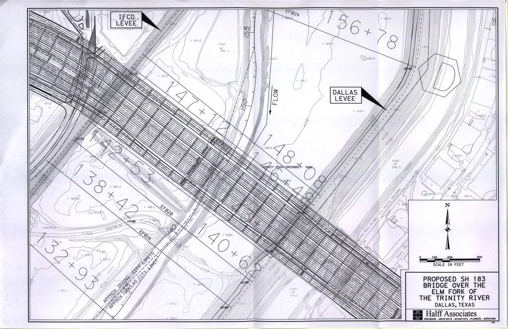
2 I. General Existing Structure Description TxDOT SH 183 Master Drainage Study Elm Fork of the Trinity River The modeled portion of the SH 183 bridge spans approximately 1,530 feet over the Elm Fork of the Trinity River. The modeled bridge is located between two levees. The west levee is in the City of Irving and is maintained by Irving Flood Control District (IFCD). The east levee is maintained by the City of Dallas. The Elm Fork forms the city boundary between Dallas and Irving. The bridge is located approximately 1,800 feet from the Regal Row exit on SH 183. The total width of the existing bridge is 132 feet. Figure 1 shows photographs of the existing bridge. II. Hydrology and Existing CDC Hydraulic Model The existing conditions hydraulic model was created by the U.S. Army Corps of Engineers for Corridor Development Certificate (CDC) evaluations. Per the description in the HEC-RAS model, the last model update was in November The CDC model covers the Upper Trinity River including the Main Stem, West, Clear, and Elm Forks. Elm Fork cross-sections in the vicinity of SH 183 were drawn to the top of the levees. The CDC model was updated by the Corps using HEC-RAS Version 4.0 Beta. The same version was used for the current hydraulic analysis. Downstream Face of Bridge Upstream Face of Bridge at IFCD Levee Figure 1. Photographs of the SH 183 over the Elm Fork of the Trinity River The flows used in this hydraulic analysis are from the CDC model. No new hydrologic analysis was performed to compute flows. The flow file in the CDC model indicates that the flows are based on fully developed conditions in the watershed. The existing CDC model contains two separate RAS geometry files. One geometry file contains the geometry for the 1-yr to 100-yr profiles and the other file contains the geometry for the 500-yr and SPF profiles from the CDC model. The CDC model has separate geometries due to the hydraulic behavior of the Trinity River. Table 1 shows the discharges that were applied at the bridge location. DRAFT 1
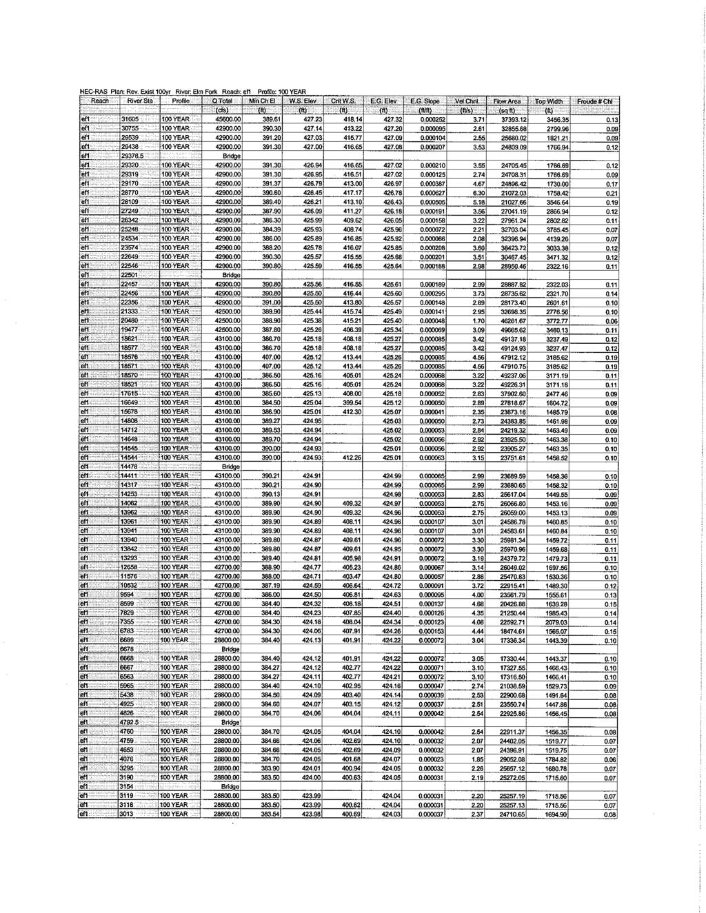
3 TxDOT SH 183 Master Drainage Study Elm Fork of the Trinity River Table 1. Existing CDC Peak Discharges Peak Discharges (cfs) 10-YR 25-YR 50-YR 100-YR 500-YR SPF Ultimate Conditions Elm Fork of the Trinity River at SH ,500 27,400 34,800 43,100 51, ,200 III. Revised Existing Hydraulic Analysis The hydraulic model from the CDC in the immediate vicinity of the SH 183 bridge over the Elm Fork was revised to incorporate data from 1978 Texas Department of Transportation (TxDOT) as-built plans which were verified by field reconnaissance. The existing model showed 23 sets of piers between the Dallas and IFCD levees which were 3 feet to 6 feet in diameter. From field reconnaissance, the number of piers was observed to be 26 and the size of piers was measured to be 2.5 feet with the exception of 4 sets of piers near the channel. The piers near the channel were measured to be 4 feet in diameter at the largest pier. The Manning s roughness values were also modified in the revised existing model based on field observations. Areas between the Dallas levee and the channel were assigned a Manning s n-value of 0.07 in the existing model. This roughness value was changed to 0.03 in the revised existing model because the vegetation in this area is mowed grass. The existing CDC model had a deck width of 130 feet whereas the aerial photo and as-built plans show the deck to be 132 feet wide. Table 2 provides a summary of water surface elevation comparisons between existing CDC and revised existing models for the 100-yr and SPF profiles. Table 2. Revised Existing Hydraulic Results 100-yr Water Surface Elevation Comparison River Station CDC Existing Elevation (ft) Revised Existing Elevation (ft) SPF Water Surface Elevation Comparison River Station CDC Existing Elevation (ft) Revised Existing Elevation (ft) Bridge Bridge DRAFT 2
4 IV. Proposed Bridge Hydraulic Analysis TxDOT SH 183 Master Drainage Study Elm Fork of the Trinity River The proposed TxDOT highway improvements will add new frontage roads and replace the existing SH 183 bridge with a wider and higher bridge. The proposed bridge will be approximately 410 feet wide based on May 2006 TxDOT preliminary schematic plans. The proposed structure span will remain the same as existing conditions. However, the height of bridge above the channel will increase approximately 7 feet. The existing foot and 4 foot diameter piers will be replaced by foot width rectangular piers. Pier locations input into the model were taken from preliminary schematic plans where proposed bent locations are shown. New deck information was entered into the model based on top of road and deck height for the proposed eastbound frontage road. The eastbound frontage road deck information was used because it has the lowest low-chord elevation. Existing cross-sections upstream and downstream were deleted from the model and new ones were added to represent the proposed bridge in the hydraulic model. The new crosssections were cut using Corps 2-foot topographic data that was used in the existing CDC model. Flow lines of the new cross-sections were interpolated between existing crosssection flow lines. Geometry changes were made to both the 1-yr to 100-yr geometry file and 500-yr to SPF geometry file. The hydraulics of the proposed SH 183 bridge were analyzed using the same methods and procedures as the existing structure hydraulics. Table 3 provides a summary of water surface elevation comparisons between revised existing and proposed models for the 100- yr and SPF profiles. Per the results, the 100-yr is contained within the levees; however, the levees do not contain 500-yr and SPF profiles. Table 3. Proposed Hydraulic Results 100-yr Water Surface Elevation Comparison River Station Revised Existing Elevation (ft) Proposed Elevation (ft) SPF Water Surface Elevation Comparison River Station Revised Existing Elevation (ft) Proposed Elevation (ft) Bridge Bridge DRAFT 3
5 V. Conclusions TxDOT SH 183 Master Drainage Study Elm Fork of the Trinity River The water surface elevations from the existing, revised existing, and proposed models were compared for 100-yr, 500-yr and SPF profiles. Due to a decrease in roughness values and size of piers, the water surface elevations were calculated to be slightly lower for the revised existing model compared to the CDC model. Water surface elevation comparisons between proposed and revised existing model results show that proposed elevations are equal to or slightly lower than the revised existing conditions. This is due to the decrease in the number of piers for proposed conditions. The Appendix includes detailed HEC-RAS output as well as a proposed bridge schematic and the existing SH 183 bridge TxDOT as-built plans. DRAFT 4
6 APPENDIX
7
8
9
10
11
12

13
14
15
16
17
18
19
20
21
22
23
24
25 Elm Fork at SH yr WSEL Comparison Existing Revised Existing Proposed Reach River Sta Profile Q Total W.S. Elev Reach River Sta Profile Q Total W.S. Elev Δ WSEL Reach River Sta Profile Q Total W.S. Elev Δ WSEL (cfs) (ft) (cfs) (ft) (ft) (cfs) (ft) (ft) ef YEAR ef YEAR ef YEAR ef YEAR ef YEAR ef YEAR ef YEAR ef YEAR ef YEAR ef YEAR ef YEAR ef YEAR ef Bridge ef Bridge ef Bridge ef YEAR ef YEAR ef YEAR ef YEAR ef YEAR ef YEAR ef YEAR ef YEAR ef YEAR ef YEAR ef YEAR ef YEAR ef YEAR ef YEAR ef YEAR ef YEAR ef YEAR ef YEAR ef YEAR ef YEAR ef YEAR ef YEAR ef YEAR ef YEAR ef YEAR ef YEAR ef YEAR ef YEAR ef YEAR ef YEAR ef YEAR ef YEAR ef YEAR ef YEAR ef YEAR ef YEAR ef Bridge ef Bridge ef Bridge ef YEAR ef YEAR ef YEAR ef YEAR ef YEAR ef YEAR ef YEAR ef YEAR ef YEAR ef YEAR ef YEAR ef YEAR ef YEAR ef YEAR ef YEAR ef YEAR ef YEAR ef YEAR ef YEAR ef YEAR ef YEAR ef YEAR ef YEAR ef YEAR ef YEAR ef YEAR ef YEAR ef YEAR ef YEAR ef YEAR ef YEAR ef YEAR ef YEAR ef YEAR ef YEAR ef YEAR ef YEAR ef YEAR ef YEAR ef YEAR ef YEAR ef YEAR ef YEAR ef YEAR ef YEAR ef YEAR ef YEAR ef YEAR ef YEAR ef YEAR ef YEAR ef YEAR ef YEAR ef YEAR ef YEAR ef Bridge ef Bridge ef Bridge ef YEAR ef YEAR ef YEAR ef YEAR ef YEAR ef YEAR ef YEAR ef YEAR ef YEAR ef YEAR ef YEAR ef YEAR ef YEAR ef YEAR ef YEAR ef YEAR ef YEAR ef YEAR ef YEAR ef YEAR ef YEAR ef YEAR ef YEAR ef YEAR ef YEAR ef YEAR ef YEAR ef YEAR ef YEAR ef YEAR I:\19000s\19474\HH\xls\WSEL Comparison.xls Page 1 of 2 7/20/2007
26 Elm Fork at SH yr WSEL Comparison Existing Revised Existing Proposed Reach River Sta Profile Q Total W.S. Elev Reach River Sta Profile Q Total W.S. Elev Δ WSEL Reach River Sta Profile Q Total W.S. Elev Δ WSEL (cfs) (ft) (cfs) (ft) (ft) (cfs) (ft) (ft) ef YEAR ef YEAR ef YEAR ef YEAR ef YEAR ef YEAR ef YEAR ef YEAR ef YEAR ef YEAR ef YEAR ef YEAR ef YEAR ef YEAR ef YEAR ef YEAR ef YEAR ef YEAR ef YEAR ef YEAR ef YEAR ef YEAR ef YEAR ef YEAR ef Bridge ef Bridge ef Bridge ef YEAR ef YEAR ef YEAR ef YEAR ef YEAR ef YEAR ef YEAR ef YEAR ef YEAR ef YEAR ef YEAR ef YEAR ef YEAR ef YEAR ef YEAR ef YEAR ef YEAR ef YEAR ef YEAR ef YEAR ef YEAR ef Bridge ef Bridge ef Bridge ef YEAR ef YEAR ef YEAR ef YEAR ef YEAR ef YEAR ef YEAR ef YEAR ef YEAR ef YEAR ef YEAR ef YEAR ef YEAR ef YEAR ef YEAR ef YEAR ef YEAR ef YEAR ef Bridge ef Bridge ef Bridge ef YEAR ef YEAR ef YEAR ef YEAR ef YEAR ef YEAR ef YEAR ef YEAR ef YEAR Note: The revised existing model includes XS data from the existing model plus added XS 14808, XS and XS The width of SH183 bridge was changed from 132 to 131 because RAS won't run if reach length is equal to dist to US XS+deck width I:\19000s\19474\HH\xls\WSEL Comparison.xls Page 2 of 2 7/20/2007
27 Elm Fork at SH yr WSEL Comparison Existing Revised Existing Proposed Reach River Sta Profile Q Total W.S. Elev Reach River Sta Profile Q Total W.S. Elev Δ WSEL Reach River Sta Profile Q Total W.S. Elev Δ WSEL (cfs) (ft) (cfs) (ft) (ft) (cfs) (ft) (ft) ef YEAR ef YEAR ef YEAR ef YEAR ef YEAR ef YEAR ef YEAR ef YEAR ef YEAR ef YEAR ef YEAR ef YEAR ef Bridge ef Bridge ef Bridge ef YEAR ef YEAR ef YEAR ef YEAR ef YEAR ef YEAR ef YEAR ef YEAR ef YEAR ef YEAR ef YEAR ef YEAR ef YEAR ef YEAR ef YEAR ef YEAR ef YEAR ef YEAR ef YEAR ef YEAR ef YEAR ef YEAR ef YEAR ef YEAR ef YEAR ef YEAR ef YEAR ef YEAR ef YEAR ef YEAR ef YEAR ef YEAR ef YEAR ef YEAR ef YEAR ef YEAR ef Bridge ef Bridge ef Bridge ef YEAR ef YEAR ef YEAR ef YEAR ef YEAR ef YEAR ef YEAR ef YEAR ef YEAR ef YEAR ef YEAR ef YEAR ef YEAR ef YEAR ef YEAR ef YEAR ef YEAR ef YEAR ef YEAR ef YEAR ef YEAR ef YEAR ef YEAR ef YEAR ef YEAR ef YEAR ef YEAR ef YEAR ef YEAR ef YEAR ef YEAR ef YEAR ef YEAR ef YEAR ef YEAR ef YEAR ef YEAR ef YEAR ef YEAR ef YEAR ef YEAR ef YEAR ef YEAR ef YEAR ef YEAR ef YEAR ef YEAR ef YEAR ef YEAR ef YEAR ef YEAR ef YEAR ef YEAR ef YEAR ef YEAR ef Bridge ef Bridge ef Bridge ef YEAR ef YEAR ef YEAR ef YEAR ef YEAR ef YEAR ef YEAR ef YEAR ef YEAR ef YEAR ef YEAR ef YEAR ef YEAR ef YEAR ef YEAR ef YEAR ef YEAR ef YEAR ef YEAR ef YEAR ef YEAR ef YEAR ef YEAR ef YEAR ef YEAR ef YEAR ef YEAR ef YEAR ef YEAR ef YEAR I:\19000s\19474\HH\xls\WSEL Comparison.xls Page 1 of 2 7/20/2007
28 Elm Fork at SH yr WSEL Comparison Existing Revised Existing Proposed Reach River Sta Profile Q Total W.S. Elev Reach River Sta Profile Q Total W.S. Elev Δ WSEL Reach River Sta Profile Q Total W.S. Elev Δ WSEL (cfs) (ft) (cfs) (ft) (ft) (cfs) (ft) (ft) ef YEAR ef YEAR ef YEAR ef YEAR ef YEAR ef YEAR ef YEAR ef YEAR ef YEAR ef YEAR ef YEAR ef YEAR ef YEAR ef YEAR ef YEAR ef YEAR ef YEAR ef YEAR ef YEAR ef YEAR ef YEAR ef YEAR ef YEAR ef YEAR ef Bridge ef Bridge ef Bridge ef YEAR ef YEAR ef YEAR ef YEAR ef YEAR ef YEAR ef YEAR ef YEAR ef YEAR ef YEAR ef YEAR ef YEAR ef YEAR ef YEAR ef YEAR ef YEAR ef YEAR ef YEAR ef YEAR ef YEAR ef YEAR ef Bridge ef Bridge ef Bridge ef YEAR ef YEAR ef YEAR ef YEAR ef YEAR ef YEAR ef YEAR ef YEAR ef YEAR ef YEAR ef YEAR ef YEAR ef YEAR ef YEAR ef YEAR ef YEAR ef YEAR ef YEAR ef Bridge ef Bridge ef Bridge ef YEAR ef YEAR ef YEAR ef YEAR ef YEAR ef YEAR ef YEAR ef YEAR ef YEAR Note: The revised existing model includes XS data from the existing model plus added XS 14808, XS and XS The width of SH183 bridge was changed from 132 to 131 because RAS won't run if reach length is equal to dist to US XS+deck width I:\19000s\19474\HH\xls\WSEL Comparison.xls Page 2 of 2 7/20/2007
29 Elm Fork at SH183 SPF WSEL Comparison Existing Revised Existing Proposed Reach River Sta Profile Q Total W.S. Elev Reach River Sta Profile Q Total W.S. Elev Δ WSEL Reach River Sta Profile Q Total W.S. Elev Δ WSEL (cfs) (ft) (cfs) (ft) (ft) (cfs) (ft) (ft) ef SPF ef SPF ef SPF ef SPF ef SPF ef SPF ef SPF ef SPF ef SPF ef SPF ef SPF ef SPF ef Bridge ef Bridge ef Bridge ef SPF ef SPF ef SPF ef SPF ef SPF ef SPF ef SPF ef SPF ef SPF ef SPF ef SPF ef SPF ef SPF ef SPF ef SPF ef SPF ef SPF ef SPF ef SPF ef SPF ef SPF ef SPF ef SPF ef SPF ef SPF ef SPF ef SPF ef SPF ef SPF ef SPF ef SPF ef SPF ef SPF ef SPF ef SPF ef SPF ef Bridge ef Bridge ef Bridge ef SPF ef SPF ef SPF ef SPF ef SPF ef SPF ef SPF ef SPF ef SPF ef SPF ef SPF ef SPF ef SPF ef SPF ef SPF ef SPF ef SPF ef SPF ef SPF ef SPF ef SPF ef SPF ef SPF ef SPF ef SPF ef SPF ef SPF ef SPF ef SPF ef SPF ef SPF ef SPF ef SPF ef SPF ef SPF ef SPF ef SPF ef SPF ef SPF ef SPF ef SPF ef SPF ef SPF ef SPF ef SPF ef SPF ef SPF ef SPF ef SPF ef SPF ef SPF ef SPF ef SPF ef SPF ef SPF ef Bridge ef Bridge ef Bridge ef SPF ef SPF ef SPF ef SPF ef SPF ef SPF ef SPF ef SPF ef SPF ef SPF ef SPF ef SPF ef SPF ef SPF ef SPF ef SPF ef SPF ef SPF ef SPF ef SPF ef SPF ef SPF ef SPF ef SPF ef SPF ef SPF ef SPF ef SPF ef SPF ef SPF I:\19000s\19474\HH\xls\WSEL Comparison.xls Page 1 of 2 7/20/2007
30 Elm Fork at SH183 SPF WSEL Comparison Existing Revised Existing Proposed Reach River Sta Profile Q Total W.S. Elev Reach River Sta Profile Q Total W.S. Elev Δ WSEL Reach River Sta Profile Q Total W.S. Elev Δ WSEL (cfs) (ft) (cfs) (ft) (ft) (cfs) (ft) (ft) ef SPF ef SPF ef SPF ef SPF ef SPF ef SPF ef SPF ef SPF ef SPF ef SPF ef SPF ef SPF ef SPF ef SPF ef SPF ef SPF ef SPF ef SPF ef SPF ef SPF ef SPF ef SPF ef SPF ef SPF ef Bridge ef Bridge ef Bridge ef SPF ef SPF ef SPF ef SPF ef SPF ef SPF ef SPF ef SPF ef SPF ef SPF ef SPF ef SPF ef SPF ef SPF ef SPF ef SPF ef SPF ef SPF ef SPF ef SPF ef SPF ef Bridge ef Bridge ef Bridge ef SPF ef SPF ef SPF ef SPF ef SPF ef SPF ef SPF ef SPF ef SPF ef SPF ef SPF ef SPF ef SPF ef SPF ef SPF ef SPF ef SPF ef SPF ef Bridge ef Bridge ef Bridge ef SPF ef SPF ef SPF ef SPF ef SPF ef SPF ef SPF ef SPF ef SPF Note: The revised existing model includes XS data from the existing model plus added XS 14808, XS and XS The width of SH183 bridge was changed from 132 to 131 because RAS won't run if reach length is equal to dist to US XS+deck width I:\19000s\19474\HH\xls\WSEL Comparison.xls Page 2 of 2 7/20/2007
31
Hydraulic Report. County Road 595 Bridge over Second River. Prepared By AECOM Brian A. Hintsala, P.E
 Prepared for: Prepared by: Marquette County Road Commission AECOM Ishpeming, MI Marquette, MI 60240279 December 9, 2011 Hydraulic Report County Road 595 Bridge over Second River Prepared By AECOM Brian
ATTACHMENT D (As referenced in Attachment B ) (Hydrology and Hydraulics Study)
 (Hydrology and Hydraulics Study)") ATTACHMENT D (As referenced in Attachment B ) (Hydrology and Hydraulics Study) Southern California Edison So Cal Gas Sub-transmission Project Hydrology and Hydraulics Study January 2014 2 Hydrology & Hydraulics
ATTACHMENT D (As referenced in Attachment B ) (Hydrology and Hydraulics Study) Southern California Edison So Cal Gas Sub-transmission Project Hydrology and Hydraulics Study January 2014 2 Hydrology & Hydraulics
Appendix C. 5% Design Plan and Profile Drawings/ Additional Design Information. South Oak Cliff Corridor Blue Line Extension
 Appendix C 5% Design Plan and Profile Drawings/ Additional Design Information The 5% plan and profile drawings were provided in a separate volume with the Draft Local EA and have not changed. Hard copies
EAGLE RIVER and COLORADO RIVER
 FLOODPLAIN INFORMATION REPORT EAGLE RIVER and COLORADO RIVER EAGLE COUNTY, COLORADO PREPARED FOR: EAGLE COUNTY, COLORADO and the COLORADO WATER CONSERVATION BOARD This Floodplain Information Report of
PUBLIC INFRASTRUCTURE PROJECTS
 PUBLIC INFRASTRUCTURE PROJECTS FM 664 / OVILLA ROAD WIDENING & IMPROVEMENTS FM 664 / OVILLA ROAD CONNECTS US 287 WITH I-45 (SOURCE: TEXAS DEPARTMENT OF TRANSPORTATION. 2016 FM 664 / OVILLA ROAD WIDENING
I-820 (East) Project Description. Fort Worth District. Reconstruct Southern I-820/SH 121 Interchange
 Project Description. Fort Worth District. Reconstruct Southern I-820/SH 121 Interchange") I-820 (East) Project Description Fort Worth District Reconstruct Southern I-820/SH 121 Interchange I-820 from approximately 2,000 feet north of Pipeline Road/Glenview Drive to approximately 3,200 feet
I-820 (East) Project Description Fort Worth District Reconstruct Southern I-820/SH 121 Interchange I-820 from approximately 2,000 feet north of Pipeline Road/Glenview Drive to approximately 3,200 feet
STRUCTURE S-13. Revised 2/21/02
 STRUCTURE S-13 This structure is a pumping station with a gated spillway which can control flows which bypass the pumps. The structure is located in Canal 11 (South New River Canal) about 300 feet west
SOUTHERN GATEWAY. Transportation and Trinity River Project Committee 11 May 2015
 SOUTHERN GATEWAY Transportation and Trinity River Project Committee 11 May 2015 Southern Gateway Project History Began in 2001 as a Major Investment Study [ MIS ], Schematic, and Environmental Assessment
FREQUENTLY ASKED QUESTIONS
 THE PROJECT Last updated on 2/19/16 FREQUENTLY ASKED QUESTIONS What s happening on Highway 169? The Minnesota Department of Transportation (MnDOT) is planning to rebuild and repair the infrastructure on
Appendix G Aquilla Lake Pool Rise Recreational Resources
 Appendix G Aquilla Lake Pool Rise Recreational Resources 1. INTRODUCTION The purpose of this appendix is to document the impacts of a 2.5 ft (Alternative A), 4.5 ft (Alternative B), and 6.5 ft. (Alternative
FREQUENTLY ASKED QUESTIONS
 THE PROJECT Last updated on 9/8/16 FREQUENTLY ASKED QUESTIONS What s happening on Highway 169? The Minnesota Department of Transportation (MnDOT) is planning to rebuild and repair the infrastructure on
NORTH HOUSTON HIGHWAY IMPROVEMENT PROJECT (NHHIP): SEGMENT 3. April 19, 2018 NHHIP April 19, 2018
: SEGMENT 3. April 19, 2018 NHHIP April 19, 2018") NORTH HOUSTON HIGHWAY IMPROVEMENT PROJECT (NHHIP): SEGMENT 3 April 19, 2018 NHHIP OVERVIEW NHHIP divided into 3 Segments: Segment 1: I-45: Beltway 8 to I-610 (9 mi) 45 Segment 2: I-45: I-610 to I-10 (3
NORTH HOUSTON HIGHWAY IMPROVEMENT PROJECT (NHHIP): SEGMENT 3 April 19, 2018 NHHIP OVERVIEW NHHIP divided into 3 Segments: Segment 1: I-45: Beltway 8 to I-610 (9 mi) 45 Segment 2: I-45: I-610 to I-10 (3
Memorandum October 5, 2017
 614 Magnolia Avenue Ocean Springs, Mississippi 39564 228.818.9626 Memorandum October 5, 2017 To: Gary Miller, U.S. Environmental Protection Agency From: David Keith, John Laplante, Matt Henderson, and
GATTIS SCHOOL RD / SH 130 SUBDIVISION
 AMISTAD DR MEADOWILD DR NO. DESCRIPTION INDEX ROYAL BURGESS DR. E NAKOMA SITE SH 130 CITY LIMITS LITTLE LAKE RD KAATZ LN ESTATE DR DANA DR MARJORIE DR 1 COVER 2 PRELIMINARY PLAT 3 EXISTING CONDITIONS 4
Purpose and Need Report
 Purpose and Need Report State Highway (SH) 29 From Southwestern Boulevard to SH 95 Williamson County, Texas (CSJ: 0337-02-045) Prepared by Blanton & Associates, Inc. Date: November, 2015 The environmental
MASTER THOROUGHFARE PLAN
 MASTER THOROUGHFARE PLAN Roadway Impact Fee July 2016 Prepared for Town of Northlake HALFF ASSOCIATES, INC. ENGINEERS SURVEYORS SCIENTISTS TBPE #F-312 PRELIMINARY FOR INTERIM REVIE ONLY These documents
F:\PROJ\ \dwg\Alt-bridge-alignments.dwg, 17-2, 11/12/ :22:17 PM, saamhu, Acrobat PDFWriter
 F:\PROJ\55211014\dwg\Alt-bridge-alignments.dwg, 17-2, 11/12/2002 03:22:17 PM, saamhu, Acrobat PDFWriter MERRIFIELD RIVER CROSSING METHOD OF CHANGE FROM ID# ISSUES MEASUREMENT UNITS VALUE BASE CONDITIONS
Request for Design Exception (#1) S.M. Wright Phase IIB
 S.M. Wright Phase IIB") Request for Design Exception (#1) S.M. Wright Phase IIB County: Dallas CSJ s: 0092-01-059, 0092-14-088 Project Limits: From Pennsylvania Avenue to North of Al Lipscomb Way Date: June 28, 2016 Proposed
Request for Design Exception (#1) S.M. Wright Phase IIB County: Dallas CSJ s: 0092-01-059, 0092-14-088 Project Limits: From Pennsylvania Avenue to North of Al Lipscomb Way Date: June 28, 2016 Proposed
Projected 2011 Missouri River Flood Elevations
 Projected 2011 Missouri River Flood Elevations Kansas City District, US Army Corps of Engineers The following table presents two water surface profiles based on the likely range of flows that are expected
HYDROLOGIC/HYDRAULIC ANALYSIS REPORT FOR THE TROLLEY BROOK CULVERT ASHLAND, MA
 HYDROLOGIC/HYDRAULIC ANALYSIS REPORT FOR THE TROLLEY BROOK CULVERT ASHLAND, MA Prepared for: THE TOWN OF ASHLAND BOARD OF SELECTMEN AND PLANNING DEPARTMENT Prepared by: June 3, 216 Hydrologic/Hydraulic
MAP OR PHOTO. Public Meeting & Open House July 23, Project Roadway Limits From: FM 1957 To: FM 471. Counties Bexar & Medina
 Public Meeting & Open House July 23, 2013 Project Roadway Limits From: FM 1957 To: FM 471 MAP OR PHOTO Counties Bexar & Medina 1 I. Project History II. III. IV. Project Overview Project Alternatives Response
S.M. Wright Project (I-45, US 175, SH 310) and Road to Work Opportunity Program. Transportation and Trinity River Project Committee May 23, 2016
 and Road to Work Opportunity Program. Transportation and Trinity River Project Committee May 23, 2016") 635 S.M. Wright Project (I-45, US 175, SH 310) and Road to Work Opportunity Program Transportation and Trinity River Project Committee May 23, 2016 Project Scope Increase safety by removing the existing
635 S.M. Wright Project (I-45, US 175, SH 310) and Road to Work Opportunity Program Transportation and Trinity River Project Committee May 23, 2016 Project Scope Increase safety by removing the existing
Traffic Engineering Study
 Traffic Engineering Study Bellaire Boulevard Prepared For: International Management District Technical Services, Inc. Texas Registered Engineering Firm F-3580 November 2009 Executive Summary has been requested
DART Priorities Overview
 City of Dallas Transportation and Trinity River Project Committee DART Priorities Overview Gary C. Thomas President/Executive Director August 10, 2015 City of Dallas Transportation & Trinity River Committee
Appendix I. Canning River Fan Stream Data
 Appendix I Canning River Fan Stream Data Table 1: Available Stream Width and Bankfull Data Collected on the Canning River Fan Within 5 Miles of the Coast Stream Width (ft) Ordinary Top of Flood- Site
City of Peachtree City
 City of Peachtree City Lake Peachtree Spillway Replacement City Council Update September 15, 2016 Project Team Integrated Science & Engineering 1 Spillway Alternatives Analysis Spillway Alternatives Evaluated
ALBENI FALLS DAM AND LAKE PEND OREILLE
 ALBENI FALLS DAM AND LAKE PEND OREILLE Fall Public Meeting 237 237 237 217 217 217 200 200 200 0 0 0 163 163 163 131 132 122 Aug. 7, 2017 255 255 255 239 65 53 80 119 27 252 174.59 83 36 118 110 135 120
PARISH OF ASCENSION OFFICE OF PLANNING AND DEVELOPMENT PLANNING DEPARTMENT
 1. Call To Order 2. Roll Call of Members 3. Introduction of Staff 4. Chairman's Comments PARISH OF ASCENSION OFFICE OF PLANNING AND DEVELOPMENT PLANNING DEPARTMENT Joint Planning and Zoning Meeting March
CTA Blue Line Study Area
 CTA Blue Line Study Area HISTORY OF THE CTA BLUE LINE / I-290 SYSTEM Blue Line / I-290 infrastructure is 55 years old First integrated transit / highway facility in the U.S. PROJECT STUDY AREA EXISTING
Traffic Impact Analysis. Alliance Cole Avenue Residential Site Dallas, Texas. Kimley-Horn and Associates, Inc. Dallas, Texas.
 Traffic Impact Analysis Alliance Cole Avenue Residential Site Dallas, Texas February 15, 2018 Kimley-Horn and Associates, Inc. Dallas, Texas Project #064524900 Registered Firm F-928 Traffic Impact Analysis
Transportation & Traffic Engineering
 Transportation & Traffic Engineering 1) Project Description This report presents a summary of findings for a Traffic Impact Analysis (TIA) performed by A+ Engineering, Inc. for the Hill Country Family
CHINO DESALTER PHASE 3
 CHINO DESALTER PHASE 3 Comprehensive Predesign Report Prepared for Jurupa Community Services District, City of Ontario, and Western Municipal Water District REVISED FINAL December 2010 Jurupa Community
MEMORANDUM. Figure 1. Roundabout Interchange under Alternative D
 MEMORANDUM Date: To: Liz Diamond, Dokken Engineering From: Subject: Dave Stanek, Fehr & Peers Western Placerville Interchanges 2045 Analysis RS08-2639 Fehr & Peers has completed a transportation analysis
Bi-County Transitway/ Bethesda Station Access Demand Analysis
 Bi-County Transitway/ Bethesda Station Access Demand Analysis Prepared for: Washington Metropolitan Area Transit Authority Office of Planning and Project Development May 2005 Prepared by: in conjunction
INDIANA DEPARTMENT OF TRANSPORTATION PAGE 1 NOTICE TO HIGHWAY CONTRACTORS
 INDIANA DEPARTMENT OF TRANSPORTATION PAGE 1 NOTICE TO HIGHWAY CONTRACTORS DATE OF LETTING: March 04, 2015 TIME OF LETTING: 10:00 AM EASTERN STD DESIGN BUILD CONTRACTS Sealed proposals for certain highway
Craig Scheffler, P.E., PTOE HNTB North Carolina, P.C. HNTB Project File: Subject
 TECHNICAL MEMORANDUM To Kumar Neppalli Traffic Engineering Manager Town of Chapel Hill From Craig Scheffler, P.E., PTOE HNTB North Carolina, P.C. Cc HNTB Project File: 38435 Subject Obey Creek TIS 2022
CNG FUELING STATION INITIAL STUDY FULLERTON JOINT UNION HIGH SCHOOL DISTRICT. Appendices
 CNG FUELING STATION INITIAL STUDY FULLERTON JOINT UNION HIGH SCHOOL DISTRICT Appendices Appendix F Parking Study April 2016 CNG FUELING STATION INITIAL STUDY FULLERTON JOINT UNION HIGH SCHOOL DISTRICT
Truss Retrofit to Mitigate Substructure Displacements at I-20 Mississippi River Bridge at Vicksburg
 Truss Retrofit to Mitigate Substructure Displacements at I-20 Mississippi River Bridge at Vicksburg Zolan Prucz, Ph.D., P.E., Modjeski and Masters, Inc. New Orleans, LA 2013 Louisiana Transportation Engineering
2005 City of Santa Paula Potable Water System Master Plan Amendment
 2005 City of Santa Paula Potable Water System Master Plan Amendment City of Santa Paula Project Engineer Randy Toedter, PE Brian Yanez June, 2012 970 Ventura Street Santa Paula, CA 93060 PURPOSE OF THE
Travel Forecasting Methodology
 Travel Forecasting Methodology Introduction This technical memorandum documents the travel demand forecasting methodology used for the SH7 BRT Study. This memorandum includes discussion of the following:
Appendix F-1 Description of the Long-Term Alternatives
 Appendix F-1 Description of the Long-Term Alternatives Memorandum Page 1 of 21 Project No. 9309 Phase 280 Date June 2, 2015 From Chris Sidlar (LEA) To Edward Presta / City of Toronto C.C. Terry Wallace
STATE LOOP 195 PUBLIC MEETING. Footer Text
 STATE LOOP 195 PUBLIC MEETING STATE LOOP 195 From FM 755 to 1 mile west of Loma Blanca Rd Public Meeting Agenda Welcome & Introductions Octavio Saenz TxDOT Public Information Officer Technical Overview
Appendix E Water Supply Modeling
 Supply Modeling Modesto Irrigation District Treatment Plant Expansion Project Modeling I. Introduction The Modesto Irrigation District (MID) is situated adjacent to and north of the Tuolumne River. Over
Subarea Study. Manning Avenue (CSAH 15) Corridor Management and Safety Improvement Project. Final Version 1. Washington County.
 Corridor Management and Safety Improvement Project. Final Version 1. Washington County.") Subarea Study Manning Avenue (CSAH 15) Corridor Management and Safety Improvement Project Final Version 1 Washington County June 12, 214 SRF No. 138141 Table of Contents Introduction... 1 Forecast Methodology
Subarea Study Manning Avenue (CSAH 15) Corridor Management and Safety Improvement Project Final Version 1 Washington County June 12, 214 SRF No. 138141 Table of Contents Introduction... 1 Forecast Methodology
Revising the Historic Monthly Mean Niagara River Flow at Buffalo to Reflect Better Estimates of Maid-of-the-Mist Pool Outflows
 Revising the Historic Monthly Mean Niagara River Flow at Buffalo to Reflect Better Estimates of Maid-of-the-Mist Pool Outflows 1961-2007 Background The Niagara River flow at Buffalo is currently computed
INFLOW DESIGN FLOOD CONTROL SYSTEM PLAN
 INFLOW DESIGN FLOOD CONTROL SYSTEM PLAN CFR 257.82(c) Bottom Ash Complex Mitchell Power Plant Marshall County, West Virginia October, 2016 Prepared for: Wheeling Power Company & Kentucky Power Company
Volume 1 Traffic Impact Analysis Turtle Creek Boulevard Dallas, Texas. Kimley-Horn and Associates, Inc. Dallas, Texas.
 Volume 1 Traffic Impact Analysis 2727 Dallas, Texas June 18, 2018 Kimley-Horn and Associates, Inc. Dallas, Texas Project #064523000 Registered Firm F-928 Traffic Impact Analysis 2727 Dallas, Texas Prepared
Appendix I Draft Transmission Towers and Lines Relocation Options at the Port of Long Beach
 Appendix I Draft Transmission Towers and Lines Relocation Options at the Port of Long Beach Transmission Towers & Lines Relocation Options at the Port of Long Beach December 2008 Prepared by Parsons 2201
NORTH HOUSTON HIGHWAY IMPROVEMENT PROJECT (NHHIP)
") NORTH HOUSTON HIGHWAY IMPROVEMENT PROJECT (NHHIP) Project Overview Briefing Packet March 2017 PROJECT OVERVIEW Environmental Impact Statement (EIS) Project divided into 3 Segments Segment 1: Beltway 8
NORTH HOUSTON HIGHWAY IMPROVEMENT PROJECT (NHHIP) Project Overview Briefing Packet March 2017 PROJECT OVERVIEW Environmental Impact Statement (EIS) Project divided into 3 Segments Segment 1: Beltway 8
CONCEPTUAL UTILITY REPORT FOR THE CANYONS PHASE 1 CITY OF CASTLE PINES, CO
 CONCEPTUAL UTILITY REPORT FOR THE CANYONS PHASE 1 CITY OF CASTLE PINES, CO PREPARED FOR: SHEA HOMES 9380 STATION ST., SUITE 600 LONE TREE, CO 80124 PHONE: 303-791-8180 CONTACT: RYAN MCDERMED PREPARED BY:
Freeway Weaving and Ramp Junction Analysis
 TEXAS TECH UNIVERSITY Freeway Weaving and Ramp Junction Analysis Along IH 27 at Plainview, TX Hao Xu, Jared A. Squyres, Wesley Kumfer, and Hongchao Liu 7/15/2011 Table of Contents Project Description...
Task Force Meeting January 15, 2009
 Task Force Meeting January 15, 2009 Study Update August 14 th Task Force Meeting Update on Traffic Projections and Financial Feasibility Study presented by Kane County and WSA staff The presentation summarized
Harlem Avenue between 63 rd and 65 th
 Harlem Avenue between 63 rd and 65 th Public Meeting #2 March 13, 2018 Summit Park District Welcome to the second Public Meeting for the preliminary engineering and environmental studies of Illinois 43
Elected Officials Briefing. North Metro Rail Line Update. February 9, 2017
 Elected Officials Briefing North Metro Rail Line Update February 9, 2017 Dave Genova, RTD General Manager and CEO Openings 2016-2017 Flatiron Flyer, Jan. 3, 2016 University of Colorado A Line, April 22,
TRAFFIC IMPACT STUDY DERRY GREEN CORPORATE BUSINESS PARK MILTON SECONDARY PLAN MODIFICATION
 TRAFFIC IMPACT STUDY DERRY GREEN CORPORATE BUSINESS PARK MILTON SECONDARY PLAN MODIFICATION TRAFFIC IMPACT STUDY DERRY GREEN CORPORATE BUSINESS PARK MILTON SECONDARY PLAN MODIFICATION DECEMBER 24 UPDATED
MONITORING AND RESEARCH DEPARTMENT
 MONITORING AND RESEARCH DEPARTMENT REPORT NO. 10-01 EVALUATION OF THE SETTLING CHARACTERISTICS OF NORTH SIDE WATER RECLAMATION PLANT COMBINED SOLIDS AND STICKNEY WATER RECLAMATION PLANT PRELIMINARY SLUDGE
Note: The October 2007 version of this report has been updated in this December 2008 report to present costs in year 2007 dollars.
 Sound Transit Phase 2 South Corridor LRT Design Report: SR 99 and I-5 Alignment Scenarios (S 200 th Street to Tacoma Dome Station) Tacoma Link Extension to West Tacoma Prepared for: Sound Transit Prepared
Final Technical. Memorandum
 Federal Emergency Management Agency Task Or rder #34 Final Technical Memorandum HYDROLOGIC REVIEW FOR THE VENTURA RIVER WATERSHED AND SEVERAL TRIBUTARY STREAMS FLOOD INSURANCE STUDY Ventu ra County, CA
Appendix 3 Traffic Technical Memorandum
 Appendix 3 Traffic Technical Memorandum DRAFT TECHNICAL MEMORANDUM Southport Connector Project Traffic Development Comparison of Future Year Model Results Date: September 10, 2015 Project #:11730.030 To:
Exhibit F - UTCRS. 262D Whittier Research Center P.O. Box Lincoln, NE Office (402)
") UTC Project Information Project Title University Principal Investigator PI Contact Information Funding Source(s) and Amounts Provided (by each agency or organization) Exhibit F - UTCRS Improving Safety
UTC Project Information Project Title University Principal Investigator PI Contact Information Funding Source(s) and Amounts Provided (by each agency or organization) Exhibit F - UTCRS Improving Safety
TIMBERVINE TRANSPORTATION IMPACT STUDY FORT COLLINS, COLORADO JANUARY Prepared for:
 TIMBERVINE TRANSPORTATION IMPACT STUDY FORT COLLINS, COLORADO JANUARY 2014 Prepared for: Hartford Companies 1218 W. Ash Street Suite A Windsor, Co 80550 Prepared by: DELICH ASSOCIATES 2272 Glen Haven Drive
NOTIFICATION OF ADDENDUM ADDENDUM NO. 2 DATED 5/03/2013
 NOTIFICATION OF ADDENDUM ADDENDUM NO. 2 DATED 5/03/2013 Control 6237-93-001 Project RMC - 623793001 Highway US0075 County DALLAS Ladies/Gentlemen: Attached please find an addendum on the above captioned
Minimization 36 CFR (b)
") Rico West Dolores Roads and Trails (Travel Management) Project Draft Record of Decision, Attachment 6 Travel Rule for Motor Vehicle designations of trails and areas (Minimization ) As described in the
Rico West Dolores Roads and Trails (Travel Management) Project Draft Record of Decision, Attachment 6 Travel Rule for Motor Vehicle designations of trails and areas (Minimization ) As described in the
APPENDIX A Interstate 26 Widening Traffic Analysis Report
 Interstate 26 Widening MM 85-MM101, Newberry, Lexington, Richland Counties, SC Environmental Assessment APPENDIX A Interstate 26 Widening Traffic Analysis Report Interstate 26 Widening Traffic Analysis
FINAL UTILITY REPORT Eastcreek Farm Thornton, CO
 FINAL UTILITY REPORT Eastcreek Farm Thornton, CO October 14, 2016 JN: 13049 Prepared for: York 80, LLC 12460 1 st Street Eastelake, CO 80614 P: 303.457.2966 Prepared by: Jansen Strawn Consulting Engineers
PROPOSED TRINITY ROUTE -DALLAS TO FORT WORTH- Funding and Traffic Analysis. The Trinity Route proposal of a new traffic facility between the cities
 PROPOSED TRINITY ROUTE -DALLAS TO FORT WORTH- Funding and Traffic Analysis The Trinity Route proposal of a new traffic facility between the cities of Dallas and Ft. Worth can be considered in the light
RE: A Traffic Impact Statement for a proposed development on Quinpool Road
 James J. Copeland, P.Eng. GRIFFIN transportation group inc. 30 Bonny View Drive Fall River, NS B2T 1R2 May 31, 2018 Ellen O Hara, P.Eng. Project Engineer DesignPoint Engineering & Surveying Ltd. 200 Waterfront
Swale Storage/ Length Between Ditch Blocks
 Swale Storage/ Length Between Ditch Blocks Input: Roadway Grade 1.00 % Front Slope 4 :1 Bottom Width 0 ft Back Slope 3 :1 Swale Depth 1.50 ft Calculations: Cross-Sectional Swale Area = 7.88 ft 2 DITCH
BRIDGEBY BURLEIGH LAW, P.E. Bringing Back the Big Four. An unused railroad truss bridge is reinvented as a new pedestrian gateway over the Ohio River.
 An unused railroad truss bridge is reinvented as a new pedestrian gateway over the Ohio River. Bringing Back the Big Four BRIDGEBY BURLEIGH LAW, P.E. PHOTOS BY HNTB Burleigh Law (blaw@hntb.com) is a senior
Improving the Waterway While Using the Waterway ~ The Chelsea Street Bridge Replacement Project
 Improving the Waterway While Using the Waterway ~ The Chelsea Street Bridge Replacement Project An Overview of Chelsea River The Chelsea River- of strategic importance The Port of Boston handles approximately
STH 60 Northern Reliever Route Feasibility Study Report
 #233087 v3 STH 60 Northern Reliever Route Feasibility Study Report Washington County Public Works Committee Meeting September 28, 2016 1 STH 60 Northern Reliever Route Feasibility Study Hartford Area Development
Westland No. 1 Mine (Bob Ciminel 2012)
") Westland No. 1 Mine (Bob Ciminel 2012) Westland Mine No. 1 was owned by the Pittsburgh Coal Company and located at the eastern (timetable) end of the Montour Railroad s Midland Spur/Westland Branch, just
Westland No. 1 Mine (Bob Ciminel 2012) Westland Mine No. 1 was owned by the Pittsburgh Coal Company and located at the eastern (timetable) end of the Montour Railroad s Midland Spur/Westland Branch, just
RESILIENT INFRASTRUCTURE June 1 4, 2016
 RESILIENT INFRASTRUTURE June 1 4, 2016 RE-TESTING OF A FIRE-DAMAGED RIDGE Alexander M.. Au, Senior ridge Engineer, Highway Standards ranch, Ontario Ministry of Transportation, anada ASTRAT A proof load
Alternatives Analysis Findings Report
 6.0 This chapter presents estimates of the potential capital, operations and maintenance costs associated with the alternatives carried forward for detailed evaluation. The methodology used to develop
PUBLIC MEETING. Bear Creek Park Community Center. January 24, :30 pm to 7:30 pm
 PUBLIC MEETING Bear Creek Park Community Center January 24, 2017 5:30 pm to 7:30 pm PURPOSE OF THE MEETING This is an open House No formal presentation Introduce the project to the public Present existing
Downtown Lee s Summit Parking Study
 Downtown Lee s Summit Parking Study As part of the Downtown Lee s Summit Master Plan, a downtown parking and traffic study was completed by TranSystems Corporation in November 2003. The parking analysis
VALUE ENGINEERING STUDIES FINAL REPORT. Portsmouth Bypass, Phase 1 SCI PID 19415
 VALUE ENGINEERING STUDIES FINAL REPORT Portsmouth Bypass, Phase 1 SCI-823-6.81 PID 19415 PREPARED FOR: Ohio Department of Transportation District 9 650 Eastern Avenue Chillicothe, Ohio 45601 PREPARED BY:
Appendix J Traffic Impact Study
 MRI May 2012 Appendix J Traffic Impact Study Level 2 Traffic Assessment Limited Impact Review Appendix J [This page was left blank intentionally.] www.sgm-inc.com Figure 1. Site Driveway and Trail Crossing
Approximately 11,200 mm c/c (field measurement) Two glulam slab girders mm x 1210 mm; 3100 mm clear distance between girders.
 Two glulam slab girders mm x 1210 mm; 3100 mm clear distance between girders.") BRIDGE INSPECTION BRIDGE NO./NAME SI - 3041: Mt. Brenton FSR (2.00 KM) Inspection Date: October 31 st 2012 Inspected By: D. Chen, D. Harrison Year Built: 1995 Number of Spans: 1 Span Lengths: Superstructure
BRIDGE INSPECTION BRIDGE NO./NAME SI - 3041: Mt. Brenton FSR (2.00 KM) Inspection Date: October 31 st 2012 Inspected By: D. Chen, D. Harrison Year Built: 1995 Number of Spans: 1 Span Lengths: Superstructure
1.3 OVERVIEW OF THE CORRIDOR
 while the central option was a tunnel under DFW Airport. As of now, the northern access option appears to be favored. However, airport access options will continue to be studied and evaluated, and are
PERFORMANCE DATA Intermittent Volume (Parallel Flow), Standard Design
, Standard Design") FAN CURVES vs FAN SIZE A AS 05, 06, 07 1/6 H.P. Motor FAN SIZE B AS 06, 07, 08 1/6 H.P. Motor NOTES: 1. External Static Pressure (ESP) consists of down stream ductwork, coils, flex, duct, etc. 2. Pressure
FAN CURVES vs FAN SIZE A AS 05, 06, 07 1/6 H.P. Motor FAN SIZE B AS 06, 07, 08 1/6 H.P. Motor NOTES: 1. External Static Pressure (ESP) consists of down stream ductwork, coils, flex, duct, etc. 2. Pressure
STATE OF NEW HAMPSHIRE Inter-Department Communication
 STATE OF NEW HAMPSHIRE Inter-Department Communication DATE: February 11, 2010 AT (OFFICE): NHPUC FROM: Torn Frantz Director, Electric Division SUBJECT: DE 09-277: Petition by Public Service Company of
The major roadways in the study area are State Route 166 and State Route 33, which are shown on Figure 1-1 and described below:
 3.5 TRAFFIC AND CIRCULATION 3.5.1 Existing Conditions 3.5.1.1 Street Network DRAFT ENVIRONMENTAL IMPACT REPORT The major roadways in the study area are State Route 166 and State Route 33, which are shown
Challenges in a Post-Katrina Environment East-West Corridor Project Overview February, 2007
 EAST-WEST CORRIDOR Challenges in a Post-Katrina Environment East-West Corridor Project Overview February, 2007 Presentation Agenda Project Overview / Purpose and Need Highway Component Transit Component
Section 5. Manhole Inspection Report
 Section 5 Inspection Report Ypsilanti Community Utilities Authority Huron River Interceptor I/I Study Inspection Report Technical Memorandum December, 2008 Introduction Several manholes within the Huron
SECTION 9 STORM SEWER INLETS
 SECTION 9 STORM SEWER INLETS CITY OF WESTMINSTER STORM DRAINAGE DESIGN AND TECHNICAL CRITERIA SECTION 9 STORM SEWER INLETS 9.1 INTRODUCTION There are three types of inlets: curb opening, grated, and combination
APPENDIX C. Existing Utilities
 APPENDIX C Existing Utilities THIS PAGE INTENTIONALLY BLANK Existing Utilities Numerous utilities exist within the project area, including natural gas, sewer, water, electric, communications, and street
SOUTH TEXAS COMMISSION MEETING
 SOUTH TEXAS COMMISSION MEETING September 26, 2013 Pharr District Commission Meeting Pharr District: Overview The Pharr District plans, designs, builds, operates and maintains the state transportation system
State Highway 32 East TIGER Discretionary Grant Application APPENDIX C - BENEFIT COST ANALYSIS REPORT
 State Highway 32 East TIGER Discretionary Grant Application APPENDIX C - BENEFIT COST ANALYSIS REPORT April 2016 I. COST-EFFECTIVENESS ANALYSIS A Benefit-Cost Analysis (BCA) was conducted in conformance
AVERAGE DELAY PER VEHICLE EXISTING CONDITIONS AND NO BUILD ALTERNATIVE
 AVERAGE DELAY PER VEHICLE EXISTING CONDITIONS AND NO BUILD ALTERNATIVE EXISTING CONDITIONS (1) NO BUILD ALTERNATIVE () Compared to existing conditions Peak Hour/Train Scenario No Train 1 With Train No
CTA Blue Line Study Area
 1 CTA Blue Line Study Area HISTORY OF THE CTA BLUE LINE / I-290 SYSTEM Blue Line / I-290 infrastructure is 55 years old First integrated transit / highway facility in the U.S. PROJECT STUDY AREA EXISTING
LAWRENCE TRANSIT CENTER LOCATION ANALYSIS 9 TH STREET & ROCKLEDGE ROAD / 21 ST STREET & IOWA STREET LAWRENCE, KANSAS
 LAWRENCE TRANSIT CENTER LOCATION ANALYSIS 9 TH STREET & ROCKLEDGE ROAD / 21 ST STREET & IOWA STREET LAWRENCE, KANSAS TRAFFIC IMPACT STUDY FEBRUARY 214 OA Project No. 213-542 TABLE OF CONTENTS 1. INTRODUCTION...
The Participant will select one of the two Approval Categories (below) and submit the appropriate documentation.
 and submit the appropriate documentation.") FORM WCCL-PC3 WCCL TEST STAND APPROVAL PROCEDURE AND CHECKLIST AHRI CERTIFICATION PROGRAM FOR WATER-COOLED WATER CHILLING AND HEAT PUMP WATER-HEATING (WCCL) PACKAGES WCCL Participant: Date of Inspection:
FORM WCCL-PC3 WCCL TEST STAND APPROVAL PROCEDURE AND CHECKLIST AHRI CERTIFICATION PROGRAM FOR WATER-COOLED WATER CHILLING AND HEAT PUMP WATER-HEATING (WCCL) PACKAGES WCCL Participant: Date of Inspection:
IH 35 FEASIBILITY STUDY
 IH 35 FEASIBILITY STUDY COOKE COUNTY, TEXAS February 1, 2007 Prepared by: Carter & Burgess, Inc. For: The Wichita Falls District of the Texas Department of Transportation INDEX I. INTRODUCTION. 3 II. PURPOSE
Broward County Intermodal Center And People Mover. AASHTO Value Engineering Conference Presentation. September 1, 2009 San Diego, CA
 Project Development & Environment Study Broward County Intermodal Center And People Mover AASHTO Value Engineering Conference Presentation September 1, 2009 San Diego, CA Background P D & E Study Regional
COMMERCIAL SCHEME Approval No
 COMMERCIAL SCHEME Approval No. 12806 MADE at the City of Calgary, in the Province of Alberta, on ALBERTA ENERGY REGULATOR IN THE MATTER of a commercial scheme of Imperial Oil Resources Ventures Limited
To: File From: Adrian Soo, P. Eng. Markham, ON File: Date: August 18, 2015
 Memo To: From: Adrian Soo, P. Eng. Markham, ON : 165620021 Date: Reference: E.C. Row Expressway, Dominion Boulevard Interchange, Dougall Avenue Interchange, and Howard 1. Review of Interchange Geometry
West Hills Shopping Centre Lowe s Expansion Traffic Impact Study
 West Hills Shopping Centre Lowe s Expansion Traffic Impact Study Prepared for: Armel Corporation January 2015 Paradigm Transportation Solutions Ltd. 22 King Street South, Suite 300 Waterloo ON N2J 1N8
DELAWARE RIVER MAIN CHANNEL DEEPENING PROJECT
 Philadelphia Regional Port Authority U.S. Army Corps of Engineers Philadelphia District DELAWARE RIVER MAIN CHANNEL DEEPENING PROJECT Investigation of Submarine Utility Crossings Stations 249+000 to 515+000
Report Addendum. Terry Keller, SDDOT. Noise Study Technical Report I-29 from Tea Interchange to Skunk Creek Sioux Falls, South Dakota
 Report Addendum To: Terry Keller, SDDOT From: HDR Project: Noise Study Technical Report I-29 from Tea Interchange to Skunk Creek Sioux Falls, South Dakota cc: file Date: May 28, 2010; rev July 16, July