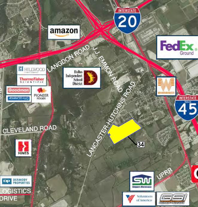
INDUSTRIAL DEVELOPMENT SITE DLH PARCEL #34 +/ GROSS ACRES DLH PARCELS #114 & #115 +/ GROSS ACRES
|
|
|
- Tracy Garrison
- 5 years ago
- Views:
Transcription


1 INDUSTRIAL DEVELOPMENT SITE DLH PARCEL #34 +/ GROSS ACRES DLH PARCELS #114 & #115 +/ GROSS ACRES YOUR GATEWAY TO GLOBAL DISTRIBUTION LANCASTER-HUTCHINS ROAD HUTCHINS, TEXAS
: Eastern portion of Parcel # 34, northern portion of Parcel # 114, and all of Parcel # 115 this zoning category requires a minimum lot size of 7,000 square")
2 DLH PARCEL #34 PROPERTY DETAILS MUNICIPALITY: CITY OF HUTCHINS, TEXAS SITE AREA: TOWN CENTER +/ ACRES SF-7 +/ ACRES TOTAL AREA ACRES ZONING: Single Family 7 ( SF-7 ): Eastern portion of Parcel # 34, northern portion of Parcel # 114, and all of Parcel # 115 this zoning category requires a minimum lot size of 7,000 square feet. Town Center ( TC ): The western portion of Parcel # 34. ROAD ACCESS: Lancaster-Hutchins Road - Along the western frontage of Parcel # 34, Lancaster-Hutchins Road is currently a forty-two-foot (42 ) wide undivided HMAC road section with two lanes and two shoulders. This portion of Lancaster-Hutchins Road has recently been reconditioned or reconstructed. According to the City of Hutchins Master Thoroughfare Plan, Lancaster-Hutchins Road adjacent to these properties will be expanded to a four-lane undivided roadway as traffic warrants. Other Existing Roads In addition to Lancaster Hutchins Road, there are several existing streets which dead end into the Property from the residential subdivision on the north boundary lines Prasifka Street, and South JJ Lemmon Road both of which connect to West Palestine Road, the major east west link to IH-45. UTILITIES: Sanitary Sewer A 12-inch sanitary sewer main is located within the Lancaster-Hutchins Road rightof-way adjacent to Parcel # 34. Currently, this line is only providing service to ADESA Auto Auction; therefore, sufficient sanitary sewer capacity is in place to serve the Subject Tracts. Depth of the sanitary sewer main could require an on-site lift station and force main to provide service. In addition, the adjacent residential subdivision, Hutchins Heights, contains three (3) 6-inch and one (1) 8-inch sanitary sewer stub-outs into Parcel # 34. Depth and capacity of these stub-outs would need to be field verified prior to connection. Water A 16-inch water main is located within the Lancaster-Hutchins Road right-of-way adjacent to Parcel # 29, 30, and 31. This 16-inch main is feed directly feed by the City of Hutchins one-million gallon (1.0MG) elevated storage tank which is located adjacent to Parcel # 28. In addition, an 8-inch water main is located in South J.J. Lemmon Road right-of-way adjacent to Parcel #34. Electric Oncor Electric Delivery ( Oncor ) overhead distribution power is located within Lancaster- Hutchins Road right-of-way. Also, Oncor has a 13.2-acre approximately 3,200 feet southwest of the intersection of Witt Road and Lancaster-Hutchins Road. Telephone AT&T overhead service lines are located within Lancaster-Hutchins Road. Gas ATMOS Energy has a 6-inch intermediate pressure line within Lancaster-Hutchins Road rightof-way. YOUR GATEWAY TO GLOBAL DISTRIBUTION 21 separate parcels totaling +/-627 acres Divisible; sites starting at 5.7 acres to over 114 acres Sites near the Union Pacific intermodal terminal Interstate highway access Lancaster Regional Airport is adjacent Foreign Trade Zone Triple Freeport Tax Exemption EB-5 design program

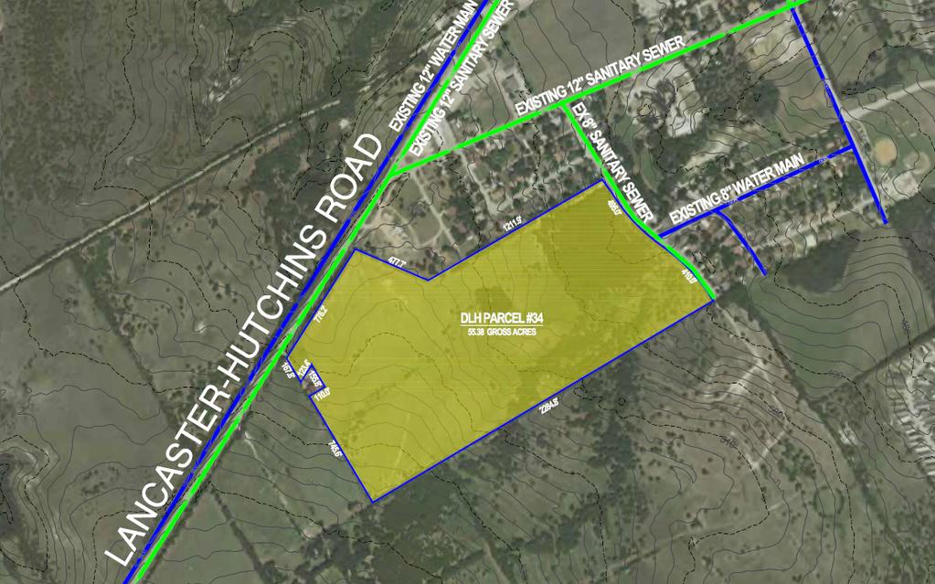
3 DLH PARCEL #34 +/ GROSS ACRES LANCASTER-HUTCHINS ROAD HUTCHINS, TEXAS (CAN BE SUBDIVIDED)
4 DLH PARCEL #114 & #115 PROPERTY DETAILS SITE AREA: DLH MASTER PARCEL # ACRES DLH MASTER PARCEL # ACRES TOTAL AREA ACRES MUNICIPALITY: CITY OF HUTCHINS, TEXAS ZONING: Single Family 7 ( SF-7 ): Northern portion of Parcel # 114 and all of Parcel # 115 This zoning category requires a minimum lot size of 7,000 square feet. Logistics Port B - ( LPB ): The southern portion of Parcel # 114. This zoning designation is a limited industrial zone that provides for a modern type of industrial use or industrial park. Limitations are placed on uses to restrict the outside activities and other potentially adverse influences. APPROXIMATE PARCEL # ZONING ACRES DU/A # OF LOTS 114 SF LPB SF ROAD ACCESS: Lancaster-Hutchins Road - Along the western frontage of Parcel # 34, Lancaster-Hutchins Road is currently a forty-two-foot (42 ) wide undivided HMAC road section with two lanes and two shoulders. This portion of Lancaster-Hutchins Road has recently been reconditioned or reconstructed. According to the City of Hutchins Master Thoroughfare Plan, Lancaster-Hutchins Road adjacent to these properties will be expanded to a four-lane undivided roadway as traffic warrants. Other Existing Roads In addition to Lancaster Hutchins Road, there are several existing streets which dead end into the Property from the residential subdivision on the north boundary lines Prasifka Street, and South JJ Lemmon Road both of which connect to West Palestine Road, the major east west link to IH-45. UTILITIES: Sanitary Sewer A 12-inch sanitary sewer main is located within the Lancaster-Hutchins Road rightof-way adjacent to Parcel # 34. Currently, this line is only providing service to ADESA Auto Auction; therefore, sufficient sanitary sewer capacity is in place to serve the Subject Tracts. Depth of the sanitary sewer main could require an on-site lift station and force main to provide service. In addition, the adjacent residential subdivision, Hutchins Heights, contains three (3) 6-inch and one (1) 8-inch sanitary sewer stub-outs into Parcel # 34. Depth and capacity of these stub-outs would need to be field verified prior to connection. Water A 16-inch water main is located within the Lancaster-Hutchins Road right-of-way adjacent to Parcel # 29, 30, and 31. This 16-inch main is feed directly feed by the City of Hutchins one-million gallon (1.0MG) elevated storage tank which is located adjacent to Parcel # 28. In addition, an 8-inch water main is located in South J.J. Lemmon Road right-of-way adjacent to Parcel #34. Electric Oncor Electric Delivery ( Oncor ) overhead distribution power is located within Lancaster- Hutchins Road right-of-way. Also, Oncor has a 13.2-acre approximately 3,200 feet southwest of the intersection of Witt Road and Lancaster-Hutchins Road. Telephone AT&T overhead service lines are located within Lancaster-Hutchins Road. Gas ATMOS Energy has a 6-inch intermediate pressure line within Lancaster-Hutchins Road rightof-way.


5 DLH PARCEL #114 & #115 +/ GROSS ACRES LANCASTER-HUTCHINS ROAD HUTCHINS, TEXAS (CAN BE SUBDIVIDED) 115


6 As your company plans for future growth, whether it s locating a site for a new build-to-suit facility or looking for readily-available building space in the Dallas/Fort Worth market, the Dallas Logistics Hub is the hot spot in North Texas. The Hub hosts high-tech, eco-friendly buildings in an unparalleled central location. Nowhere else can you find an Inland Port that sits at the forefront of technology, boasts a diminutive environmental footprint, and is surrounded by the most sophisticated rail, intermodal, and highway infrastructure in the country. The Hub provides shovel-ready sites and industrial space for lease to assist in maximizing speed, minimizing costs, and increasing flexibility in your company s supply chain. For additional information: TERRY DARROW Managing Director terry.darrow@am.jll.com RANDY TOUCHSTONE Vice President randy.touchstone@am.jll.com For additional information visit our website at:
PUBLIC INFRASTRUCTURE PROJECTS
 PUBLIC INFRASTRUCTURE PROJECTS FM 664 / OVILLA ROAD WIDENING & IMPROVEMENTS FM 664 / OVILLA ROAD CONNECTS US 287 WITH I-45 (SOURCE: TEXAS DEPARTMENT OF TRANSPORTATION. 2016 FM 664 / OVILLA ROAD WIDENING
Cleary Rd and Belvedere Rd West Palm Beach, FL Great Centralized PB County location. Easy access to I-95 and Fl. Turnpike
 and Belvedere Rd For more information contact: John Hoecker, CCIM, CPM, CSM President 5613668424 John@JupiterRealtyCompany.com Great Centralized PB County location. Easy access to I-95 and Fl. Turnpike
Table of Contents PRIME INDUSTRIAL LAND. Arrowhead Drive /- acres Carson City, Nevada. For Sale $3.95 / SF
 Arrowhead Dr., Carson City, NV Table of Contents Property Description...2 Lot Information...3 Lot Area Maps...4 Parcel Map...5 Powerline Map...6 Site Vicinity...7 Water & Sewer Lines...8 Test Pit Location...9
Tax Increment Reinvestment Zone #1 City of Kaufman, Texas
 Tax Increment Reinvestment Zone #1 City of Kaufman, Texas PRELIMINARY PROJECT AND FINANCING PLAN DECEMBER 2015 Foreword Table of Contents Introduction TIRZ Boundary Current Conditions & Ownership Proposed
I-820 (East) Project Description. Fort Worth District. Reconstruct Southern I-820/SH 121 Interchange
 Project Description. Fort Worth District. Reconstruct Southern I-820/SH 121 Interchange") I-820 (East) Project Description Fort Worth District Reconstruct Southern I-820/SH 121 Interchange I-820 from approximately 2,000 feet north of Pipeline Road/Glenview Drive to approximately 3,200 feet
I-820 (East) Project Description Fort Worth District Reconstruct Southern I-820/SH 121 Interchange I-820 from approximately 2,000 feet north of Pipeline Road/Glenview Drive to approximately 3,200 feet
Project Home - Sites in Central Pennsylvania
 5 Project Home - Sites in Central Pennsylvania Property Report (SEEDCO INDUSTRIAL PARK) Availability For Sale Sale Price $24,000.00 For Lease Sale Price Comments KOZ & KOEZ Sites $23,000 - $25,000/acre
53, ,750 SF INDUSTRIAL STEELE CREEK ROAD CHARLOTTE, NORTH CAROLINA
 53,000-250,750 SF INDUSTRIAL 11130 STEELE CREEK ROAD CHARLOTTE, NORTH CAROLINA sits on 25 acres in Charlotte s premier Southwest submarket near the intersection of Westinghouse Boulevard and Steele Creek
Industrial/Business Parks Weatherford, Texas
 Industrial/Business Parks, Texas FM 920 to Bridgeport FM 51 to Springtown, &Decatur Future East Loop FUTURE East Loop: Est. Start ~ 2016 Est. Complete ~ 2025 (1- years) W/PC EDC Hobson Industrial Park:
11 October 12, 2011 Public Hearing APPLICANT:
 11 October 12, 2011 Public Hearing APPLICANT: CARING TRANSITIONS PROPERTY OWNER: HARDEE REALTY CORPORATION REQUEST: Conditional Use Permit (motor vehicle rental) STAFF PLANNER: Leslie Bonilla ADDRESS /
VACANT LAND FOR SALE: 20.4 Acres
 To Minneapolis > McDonalds U.S. Hwy 169 Enterprise Dr. Coborn s < To Mankato Cambria Matt Saxe Chevrolet Buick Hickory Blvd. This property is ideally located near the U.S. Highway 169 interchange in Belle
Town of Londonderry, New Hampshire NH Route 28 Western Segment Traffic Impact Fee Methodology
 Town of Londonderry, New Hampshire NH Route 28 Western Segment Traffic Impact Fee Methodology Prepared by the Londonderry Community Development Department Planning & Economic Development Division Based
CONCEPTUAL UTILITY REPORT FOR THE CANYONS PHASE 1 CITY OF CASTLE PINES, CO
 CONCEPTUAL UTILITY REPORT FOR THE CANYONS PHASE 1 CITY OF CASTLE PINES, CO PREPARED FOR: SHEA HOMES 9380 STATION ST., SUITE 600 LONE TREE, CO 80124 PHONE: 303-791-8180 CONTACT: RYAN MCDERMED PREPARED BY:
IMAGE DRIVE FOR SALE SPARTANBUBRG SOUTH CAROLINA
 FOR SALE IMAGE DRIVE SPARTANBUBRG SOUTH CAROLINA For More Information, Contact: Meghan McDuff Associate Industrial & Investment Services O 864.301.8379 F 843.725.7201 C 305.720.4403 meghan.mcduff@avisonyoung.com
2005 City of Santa Paula Potable Water System Master Plan Amendment
 2005 City of Santa Paula Potable Water System Master Plan Amendment City of Santa Paula Project Engineer Randy Toedter, PE Brian Yanez June, 2012 970 Ventura Street Santa Paula, CA 93060 PURPOSE OF THE
BOARD OF SUPERVISORS BUSINESS MEETING ACTION ITEM. Design Endorsement for Sterling Boulevard Extension
 Date of Meeting: July 20, 2017 # 6 BOARD OF SUPERVISORS BUSINESS MEETING ACTION ITEM SUBJECT: ELECTION DISTRICT: CRITICAL ACTION DATE: STAFF CONTACTS: Design Endorsement for Sterling Boulevard Extension
TABLE OF CONTENTS EXECUTIVE SUMMARY...1 INTRODUCTION...3 PROJECTED FUTURE GROWTH...3 ROADWAY IMPROVEMENT PROJECTS...4 POTENTIAL FUNDING SOURCES...
 Transportation Impact Fee Study September 2014 TABLE OF CONTENTS EXECUTIVE SUMMARY...1 INTRODUCTION...3 PROJECTED FUTURE GROWTH...3 ROADWAY IMPROVEMENT PROJECTS......4 POTENTIAL FUNDING SOURCES...7 PROPOSED
/ Planning and Zoning Staff Report Lonestar Land, LLC. - Rezone, RZ
 / Planning and Zoning Staff Report Lonestar Land, LLC. - Rezone, RZ2018-0019 Hearing Date: October 18, 2018 Development Services Department Applicant: Lonestar Land, LLC. Representative: Lance Warnick
ATTACHMENT [B] PROJECT DESCRIPTION REQUESTED CITY OF LOS ANGELES ACTIONS
![ATTACHMENT [B] PROJECT DESCRIPTION REQUESTED CITY OF LOS ANGELES ACTIONS](/thumbs/72/67299149.jpg "ATTACHMENT [B] PROJECT DESCRIPTION REQUESTED CITY OF LOS ANGELES ACTIONS") ATTACHMENT [B] PROJECT DESCRIPTION REQUESTED CITY OF LOS ANGELES ACTIONS I. Project Location The Los Angeles International Airport (LAX) Landside Access Modernization Program ( Project ) comprises approximately
ATTACHMENT [B] PROJECT DESCRIPTION REQUESTED CITY OF LOS ANGELES ACTIONS I. Project Location The Los Angeles International Airport (LAX) Landside Access Modernization Program ( Project ) comprises approximately
Prime Commercial Land in Developing Area
 W North Grand Avenue Access Road Prime Commercial Land in Developing Area Retail/Fuel Station Site off Great Access & Exposure On one of Porterville s Major East/West Corridor (North Grand) In High Traffic
The Bakersfield Spectrum
 The Bakersfield Spectrum Freeway 99/Highway 65/Merle Haggard Drive Bakersfield, California. 9 2 N e t A c r e s A v a i l a b l e f o r G r o u n d L e a s e - $ 8 5, 0 0 0 / a n n u a l r e n t Regional
Landside Access Modernization Program (LAMP)
") Landside Access Modernization Program (LAMP) LAX Los Angeles International Airport is the 2 nd busiest airport in the United States and is the largest airport in California. Since the start of the economic
Landside Access Modernization Program (LAMP) LAX Los Angeles International Airport is the 2 nd busiest airport in the United States and is the largest airport in California. Since the start of the economic
II. PROJECT DESCRIPTION
 II. PROJECT DESCRIPTION A. PROJECT APPLICANT The project applicants for the proposed Sepulveda/Rosecrans Site Rezoning are: Mar Ventures, Inc., 2050 West 190 th Street, Suite 108, Torrance, California,
Offering Memorandum. 4333, 4375 and 4415 Bandini Boulevard Vernon, CA June Prepared by: Cresa
 Offering Memorandum 4333, 4375 and 4415 Bandini Boulevard Vernon, CA 90058 June 2015 Prepared by: Cresa Confidentiality Statement The information contained in the following Marketing Brochure is proprietary
Taylor s Falls Business Park
 Site Information Taylor s Falls Business Park County Road 37, Taylors Falls, MN Chisago County HRA-EDA 12/23/2014 Taylors Falls Business Park County Road 37 Taylors Falls, MN 55084 PROPERTY FEATURES: Zoned
CECO BUILDING SYSTEMS
 Picture does not reflect current roof condition CECO BUILDING SYSTEMS 249,312 + /- Square Feet on 19.51 + /- acres Rocky Mount, North Carolina PRELIMINARY CECO BUILDING SYSTEMS 100 RED IRON ROAD ROCKY
Wentzville Parkway South Phase 2 & 2A
 Wentzville Parkway South Phase 2 & 2A Sponsor Wentzville Project No. RB18-000034 Project Type New Road TOTAL FUNDING Phase 2 Total County Sponsor Federal $10,000,000 $8,000,000 $2,000,000 $0 Phase 2A Total
STAFF REPORT # CHANGE OF ZONING
 STAFF REPORT #17-2000-0007 CHANGE OF ZONING PLANNING COMMISSION MEETING DATE: November 16, 2017 (Applicant Provided Materials / Traffic Study = Blue) 1. APPLICATION: A public hearing for an application
STH 60 Northern Reliever Route Feasibility Study Report
 #233087 v3 STH 60 Northern Reliever Route Feasibility Study Report Washington County Public Works Committee Meeting September 28, 2016 1 STH 60 Northern Reliever Route Feasibility Study Hartford Area Development
Water Major Facilities
 Water Major Facilities Water Residential (Units per Acre) Water oversize Residential 2.0 or less $6,842 per unit All Areas except RT Ph 1,2 $1,342 per gross acre Residential 2.1 to 2.5 $6,842 per unit
CHAPTER 9: VEHICULAR ACCESS CONTROL Introduction and Goals Administration Standards
 9.00 Introduction and Goals 9.01 Administration 9.02 Standards 9.1 9.00 INTRODUCTION AND GOALS City streets serve two purposes that are often in conflict moving traffic and accessing property. The higher
DEVELOPMENT PROPERTY 1627 MAXIME STREET CITY OF OTTAWA TRANSPORTATION OVERVIEW. Prepared for: Subhas Bhargava. July 9, Overview_1.
 DEVELOPMENT PROPERTY 1627 MAXIME STREET CITY OF OTTAWA TRANSPORTATION OVERVIEW Prepared for: Subhas Bhargava July 9, 2015 115-620 Overview_1.doc D. J. Halpenny & Associates Ltd. Consulting Transportation
CreekSide XVI & XVIII
 Project Overview CreekSide XVI & XVIII Building Dimensions CreekSide XVI - 155,866 square feet CreekSide XVIII - 236,140 square feet 32 clear height 50 x 54 column spacing and 60 speed bay CreekSide Advantage
Millridge Commercial Real Estate Inventory List February 2014
 Millridge Commercial Real Estate Inventory List February 2014 BUILDINGS WAKE COUNTY or Lease Heritage Office Building 3319 Heritage Trade Drive 2 story 1.01 Acre lot Yr. Built: 2006 Sale Price: $1,500,000
FINAL UTILITY REPORT Eastcreek Farm Thornton, CO
 FINAL UTILITY REPORT Eastcreek Farm Thornton, CO October 14, 2016 JN: 13049 Prepared for: York 80, LLC 12460 1 st Street Eastelake, CO 80614 P: 303.457.2966 Prepared by: Jansen Strawn Consulting Engineers
Station Evaluation. Durham-Orange Light Rail Transit Project Spring 2012
 Station Evaluation Durham-Orange Light Rail Transit Project Spring 2012 Key Ingredients for Station Development Platform Designs UNC Hospitals Station The UNC Hospitals Station Option D would be the westerly
2 MAJOR MACKENZIE DRIVE WEST JOG ELIMINATION AT HUNTINGTON ROAD CITY OF VAUGHAN
 2 MAJOR MACKENZIE DRIVE WEST JOG ELIMINATION AT HUNTINGTON ROAD CITY OF VAUGHAN The Transportation Services Committee recommends the adoption of the recommendations contained in the following report dated
LOTUS RANCH TRAFFIC IMPACT ANALYSIS. LLG Ref Senior Transportation Engineer & Charlene Sadiarin Transportation Engineer II
 TRAFFIC IMPACT ANALYSIS LOTUS RANCH El Centro, California July 31, 2015February 12, 2016 LLG Ref. 3-14-2392 Prepared by: KC Yellapu, P.E Senior Transportation Engineer & Charlene Sadiarin Transportation
Commercial Industrial Land Available
 Commercial Industrial Land Available PID: 200970010 List Price $744,292 Price Per Square Foot: $3.00 Sq. Ft. Property Details Street Address: Laredo St. & South St. Parcel ID: 200970010 City: Belle Plaine
TRAFFIC MANAGEMENT STANDARDS CITY OF GARLAND TRANSPORTATION DEPARTMENT
 TRAFFIC MANAGEMENT STANDARDS CITY OF GARLAND TRANSPORTATION DEPARTMENT JUNE 1996 TABLE OF CONTENTS 1.0 Street Design Standards 1.1 Right-of-Way Requirements 1.2 Median Openings 1.3 Sidewalks 1.4 Traffic
SPECIFICATIONS FOR 456,000 SF
 200 TECHNOLOGY DRIVE CENTERPOINT COMMERCE & TRADE PARK EAST JENKINS TOWNSHIP, PA SITE PLAN 1,038,500 SF SITE PLAN 456,000 SF - 775,000 SF Information shown is purported to be from reliable sources. No
June WASHINGTON STATE DEPARTMENT OF TRANSPORTATION Alaskan Way Viaduct and Seawall Replacement Program Seattle, Washington
 DESIGN DEVIATION NOs. 1 & 2 Horizontal Stopping Sight Distance and Shoulder Width Reduction SR 99 S. Holgate St to S. King St. Viaduct Replacement Stage 2 MP 29.89 TO MP 30.78 XL-3237 PIN-809936D June
CECO BUILDING SYSTEMS
 Picture does not reflect current roof condition CECO BUILDING SYSTEMS 249,312 + /- Square Feet on 19.51 + /- acres Rocky Mount, North Carolina CECO BUILDING SYSTEMS 100 RED IRON ROAD ROCKY MOUNT, NC 27804
For Sale or Lease Produce Processing/Cooler Facility Yuma, Arizona
 For Sale or Lease Produce Processing/Cooler Facility Yuma, Arizona 100,000 Sq. Ft. including 80,000 Sq. Ft. of Insulated Cooler Space and USDA approved Processing area and 6,000 Sq. Ft. air conditioned
A DEVELOPMENT OF & available for lease RECENTLY DELIVERED, STATE-OF-THE-ART LOGISTICS FACILITY. IMMEDIATE ACCESS TO IH-35 WITH INTERSTATE VISIBILITY.
 A DEVELOPMENT OF & available for lease RECENTLY DELIVERED, STATE-OF-THE-ART LOGISTICS FACILITY. IMMEDIATE ACCESS TO IH- WITH INTERSTATE VISIBILITY. 75,000-397,600 Sf available for lease new class a warehouse
STAFF REPORT. To: Planning Commission Meeting date: April 12, 2017 Item: UN Prepared by: Robert Eastman
 # 5 ) UN-15-17 LA SIERRA AUTO SALES SPECIAL USE PERMIT VEHICLE SALES PUBLIC HEARING STAFF REPORT To: Planning Commission Meeting date: April 12, 2017 Item: UN-15-17 Prepared by: Robert Eastman GENERAL
101, 111 and 129 St. Clair Avenue West Part Lot Control Exemption Application Final Report
 STAFF REPORT ACTION REQUIRED 101, 111 and 129 St. Clair Avenue West Part Lot Control Exemption Application Final Report Date: April 20, 2015 To: From: Wards: Reference Number: Toronto and East York Community
PADUCAH TRIPLE RAIL SPEC BUILDING. Paducah, McCracken County, Kentucky N W. Paducah Triple Rail Spec Building
 PADUCAH TRIPLE RAIL SPEC BUILDING 37 05 17.5308 N -88 42 8.9886 W I TABLE OF CONTENTS III. Aerial Map IV. Infrastructure Map V. Regional Map VI. Local Map VII. Street Map VIII. Interior Photo 1 IX. Interior
Big Easy RV & Boat Storage A Green Energy Project Jana Lane Wildomar, California
 Big Easy RV & Boat Storage A Green Energy Project 36215 Jana Lane Wildomar, California 1 PROJECT OVERVIEW Project Description The construction and operation of a solar generation facility consisting of
THE CORNERSTONE APARTMENTS TRAFFIC IMPACT STUDY R&M PROJECT NO
 THE CORNERSTONE APARTMENTS SITUATED AT N/E/C OF STAUDERMAN AVENUE AND FOREST AVENUE VILLAGE OF LYNBROOK NASSAU COUNTY, NEW YORK TRAFFIC IMPACT STUDY R&M PROJECT NO. 2018-089 September 2018 50 Elm Street,
CASE NUMBER: 15SN0627 APPLICANT: Stafford H. Cassell
 CASE NUMBER: 15SN0627 APPLICANT: Stafford H. Cassell STAFF S ANALYSIS AND RECOMMENDATION CHESTERFIELD COUNTY, VIRGINIA Magisterial District: CLOVER HILL Board of Supervisors (BOS) Public Hearing Date:
CITY OF TORRANCE PUBLIC WORKS DEPARTMENT ENGINEERING DIVISION INFRASTRUCTURE UPDATE
 CITY OF TORRANCE PUBLIC WORKS DEPARTMENT ENGINEERING DIVISION INFRASTRUCTURE UPDATE TUESDAY, DECEMBER 5, 2017 1 DISCUSSION TOPICS Update of Infrastructure Action Plan (IAP) o Sidewalk and Roadway projects
Develop ground transportation improvements to make the Airport a multi-modal regional
 Project Overview TRANSPORTATION IMPROVEMENTS WHAT ARE THE PROJECT GOALS? Transportation transportation hub. Develop ground transportation improvements to make the Airport a multi-modal regional Land Use
FREQUENTLY ASKED QUESTIONS
 THE PROJECT Last updated on 9/8/16 FREQUENTLY ASKED QUESTIONS What s happening on Highway 169? The Minnesota Department of Transportation (MnDOT) is planning to rebuild and repair the infrastructure on
Brigham City 1200 West Box Elder Creek Bridge - Widening Project Type Reconstruction
 Brigham City 1200 West Box Elder Creek Bridge - Widening Project Type Reconstruction 550 North to 650 North $ 1,750,000 $ 1,582,113 To widen an existing bridge on 1200 West over Box Elder Creek that will
Volume 1 Traffic Impact Analysis Turtle Creek Boulevard Dallas, Texas. Kimley-Horn and Associates, Inc. Dallas, Texas.
 Volume 1 Traffic Impact Analysis 2727 Dallas, Texas June 18, 2018 Kimley-Horn and Associates, Inc. Dallas, Texas Project #064523000 Registered Firm F-928 Traffic Impact Analysis 2727 Dallas, Texas Prepared
FREQUENTLY ASKED QUESTIONS
 THE PROJECT Last updated on 2/19/16 FREQUENTLY ASKED QUESTIONS What s happening on Highway 169? The Minnesota Department of Transportation (MnDOT) is planning to rebuild and repair the infrastructure on
EL DORADO COUNTY REGIONAL FIRE PROTECTION STANDARD
 EL DORADO COUNTY REGIONAL FIRE PROTECTION STANDARD EMERGENCY APPARATUS ACCESS WAYS STANDARD #B-003 EFFECTIVE 05-05-2009 PURPOSE To establish a consistent guideline for fire access roadways required by
±25,934 SF C-3 ZONED PAD
 ±25,934 SF C-3 ZONED PAD SOUTH 5TH AVENUE, TUCSON, ARIZONA CONTACT US DAVE VOLK Vice President +1 520 323 5102 david.volk@cbre.com BRUCE SUPPES Vice President +1 520 323 5155 bruce.suppes@cbre.com PROPERTY
APPENDIX C. Existing Utilities
 APPENDIX C Existing Utilities THIS PAGE INTENTIONALLY BLANK Existing Utilities Numerous utilities exist within the project area, including natural gas, sewer, water, electric, communications, and street
City of Casselberry Planning Division
 City of Casselberry Planning Division 95 Triplet Lake Drive, Casselberry, Florida 32707 Telephone (407) 262-7700, Ext. 1106 Fax (407) 262-7763 Email: ehanna@casselberry.org SIGN REGUALTIONS SEE ULDR Article
2012 Community Profile
 Eastland County TRANSPORTATION City of Eastland, County of Eastland, State of Texas, located 95 miles West of Fort Worth, 55 miles East of Abilene on Interstate 20 Air Service Abilene Regional Runway Length
Access Management Standards
 Access Management Standards This section replaces Access Control Standards on Page number 300-4 of the Engineering Standards passed February 11, 2002 and is an abridged version of the Access Management
GAINESVILLE PLANNING AND APPEALS BOARD MINUTES OF MEETING OCTOBER 8, 2013
 GAINESVILLE PLANNING AND APPEALS BOARD MINUTES OF MEETING OCTOBER 8, 2013 CALL TO ORDER Members Present: Members Absent: Staff Present: Others Present: Chairman @ 5:30 p.m. Chairman Dean Dadisman, Vice
TRAFFIC DEPARTMENT 404 EAST WASHINGTON BROWNSVILLE, TEXAS City of Brownsville Speed Hump Installation Policy
 A. GENERAL Speed humps are an effective and appropriate device for safely reducing vehicle speeds on certain types of streets when installed accordance with the provisions of this policy. In order for
Workforce Development Rankings Site Selectors Survey E-Commerce Asia Pacific
 Workforce Development Rankings Site Selectors Survey E-Commerce Asia Pacific INVESTMENT PROFILE: DETROIT REGION AEROTROPOLIS How to Fast Track Logistics Airside or landside, this Aerotropolis delivers
Alberta Aerotropolis Overview Booklet Prepared for the Leduc Partnership (City of Leduc & Leduc County)
") Alberta Aerotropolis Overview Booklet Prepared for the Leduc Partnership (City of Leduc & Leduc County) by MXD Development Strategists / Stantec June 2015 WHAT IS AN AEROTROPOLIS? An Aerotropolis is a
Alberta Aerotropolis Overview Booklet Prepared for the Leduc Partnership (City of Leduc & Leduc County) by MXD Development Strategists / Stantec June 2015 WHAT IS AN AEROTROPOLIS? An Aerotropolis is a
FACILITY EXPANDABLE TO 780,000 SF PROPERTY HIGHLIGHTS RESEARCH DR. (PARCEL 43B)
") 520,000 SF ON 104.46 ACRES 460-480 RESEARCH DR. (PARCEL 43B) CENTERPOINT COMMERCE & TRADE PARK EAST PITTSTON TOWNSHIP, PA 18640 FACILITY EXPANDABLE TO 780,000 SF LERTA APPROVED! 10-YEAR, 100% REAL ESTATE
520,000 SF ON 104.46 ACRES 460-480 RESEARCH DR. (PARCEL 43B) CENTERPOINT COMMERCE & TRADE PARK EAST PITTSTON TOWNSHIP, PA 18640 FACILITY EXPANDABLE TO 780,000 SF LERTA APPROVED! 10-YEAR, 100% REAL ESTATE
HIGHWAY 28 FUNCTIONAL DESIGN
 HIGHWAY 28 FUNCTIONAL DESIGN PUBLIC OPEN HOUSE #1 WEDNESDAY, MARCH 12, 2014 Stantec Presenters: Brad Vander Heyden, Project Engineer Neal Cormack, Project Manager Dave Parker, Project Engineer Beth Thola,
Environmental Assessment Derry Road and Argentia Road Intersection
 Air and Noise Study Environmental Assessment Derry Road and Argentia Road Intersection Project 11-4295 City of Mississauga, Region of Peel October 17, 2014 1 Region of Peel Environmental Assessment for
Existing Facilities. 9. Bordeaux 10. Slater 11. Chugwater 12. LaGrange 13. Lambert 14. Farthing 15. Altus 16. Horse Creek 17.
 High Plains ECONOMIC DEVELOPMENT D i s t r i c t Rail Transportation Southeast Wyoming Southeast Wyoming is served by both the Burlington Northern Santa Fe Railroad (BNSF) and the Union Pacific Railroad
3432 AL-20, Trinity, AL 35673
 Steed Business Park-South Parcel 3432 AL-20, Trinity, AL 35673 Listing ID: 30297069 Status: Active Property Type: Vacant Land For Sale Possible Uses: Agricultural, Hospitality Gross Land Area: 5-139 Acres
DRIVEWAY ENTRANCES GENERAL. 1. Description
 GENERAL 1. Description This standard identifies the minimum requirements that shall be met for all driveway entrances in the design and construction of elements for Arlington County Horizontal Design Standards.
FY 2013 Candidate Projects ($ Thousands) Street & Traffic Control Program - Thoroughfares
 Street & Traffic Control Program - Thoroughfares") Need Area: NT032 Alternative No.: 1 Name: Drive Council District: G Limits: Dallas to Dickson Key Map No.: 492M Type: Major Thoroughfare and Collector Super Neighborhood: WBS No.: (To be assigned by the
Need Area: NT032 Alternative No.: 1 Name: Drive Council District: G Limits: Dallas to Dickson Key Map No.: 492M Type: Major Thoroughfare and Collector Super Neighborhood: WBS No.: (To be assigned by the
Solar Farm Leases Q & A
 Cornell Cooperative Extension Sullivan County Gerald J. Skoda Extension Education Center 64 Ferndale-Loomis Road Liberty, NY 12754 p: 845-292-6180 f: 845-292-4946 e: sullivan@cornell.edu w: www.sullivancce.org
Operations Center FAQs
 RICHARDSON INDEPENDENT SCHOOL DISTRICT Where all students learn, grow and succeed Operations Center FAQs Richardson ISD is constructing an operations center on vacant district land between Greenville Avenue
NORTH HOUSTON HIGHWAY IMPROVEMENT PROJECT (NHHIP)
") NORTH HOUSTON HIGHWAY IMPROVEMENT PROJECT (NHHIP) Project Overview Briefing Packet March 2017 PROJECT OVERVIEW Environmental Impact Statement (EIS) Project divided into 3 Segments Segment 1: Beltway 8
NORTH HOUSTON HIGHWAY IMPROVEMENT PROJECT (NHHIP) Project Overview Briefing Packet March 2017 PROJECT OVERVIEW Environmental Impact Statement (EIS) Project divided into 3 Segments Segment 1: Beltway 8
Terminal Alternatives
 Chapter 5 Terminal Alternatives Missoula International Airport Master Plan Update Prepared for Missoula County Airport Authority OCTOBER 2008 Contents Section Page 5 Terminal Alternatives...5-1 5.1 Terminal
Purpose and Need Report
 Purpose and Need Report State Highway (SH) 29 From Southwestern Boulevard to SH 95 Williamson County, Texas (CSJ: 0337-02-045) Prepared by Blanton & Associates, Inc. Date: November, 2015 The environmental
Alberta Infrastructure HIGHWAY GEOMETRIC DESIGN GUIDE AUGUST 1999
 &+$37(5Ã)Ã Alberta Infrastructure HIGHWAY GEOMETRIC DESIGN GUIDE AUGUST 1999 &+$37(5) 52$'6,'()$&,/,7,(6 7$%/(2)&217(176 Section Subject Page Number Page Date F.1 VEHICLE INSPECTION STATIONS... F-3 April
Housing Development Corp of Dekalb
 Housing Development Corp of Dekalb Campaign Contributions Disclosure Form Have you as applicant, agent for applicant, property owner, or person associated with the application for property, located at,
DRIVEWAY/APPROACH PERMIT APPLICATION Applicant Type: Architect/Engineer Contractor Owner
 DRIVEWAY/APPROACH PERMIT APPLICATION Applicant Type: Architect/Engineer Contractor Owner Lake Elmo City Hall 651-747-3900 3880 Laverne Avenue North Lake Elmo, MN 55042 Project Address: Property Owner:
Investment Property. Rancho. Cordova. Peter Winterling CA RE License #
 Investment Property Rancho. Cordova Peter Winterling 916-367-6345 pmw@newmarkccarey.com CA RE License #00992375 Offering Summary Offering Price $2,300.000 Occupancy 100% Building Address City 11230 Trade
Citizens Committee for Facilities
 Citizens Committee for Facilities AGENDA Thursday, December 11, 2014 City Council Chambers 305 3 rd Avenue East -Twin Falls, Idaho 11:30 A.M. AGENDA ITEMS Purpose By 1. Discussion and possible action on
SECTION 830 "T-P" - TRAILER PARK RESIDENTIAL DISTRICT
 SECTION 830 "T-P" - TRAILER PARK RESIDENTIAL DISTRICT The "T-P" Trailer Park Residential District is created to provide for the accommodation of residential trailers at a standard consistent with the protection
EMERGING REQUIREMENTS
 Page of 0 EMERGING REQUIREMENTS EXTERNALLY INITIATED PLANT RELOCATIONS THESL distributes electricity to residential, commercial, and industrial customers via overhead and underground infrastructure. This
12 April Leakes Pty Ltd 211 Waverley Road EAST MALVERN VIC Attention: Joseph Nasr. Dear Joe,
 Our Ref: Contact: CG120569:VG Valentine Gnanakone Leakes Pty Ltd 211 Waverley Road EAST MALVERN VIC 3145 Attention: Joseph Nasr Dear Joe, 690 DERRIMUT ROAD PROPOSED RESIDENTIAL SUBDIVISION Further to our
Dulles Corridor Air Rights Study Investigation
 Dulles Corridor Air Rights Study Investigation Fairfax County Board of Supervisors Transportation Committee September 17, 2013 1 On March 19, 2013 the Fairfax County Board of Supervisors asked FCDOT staff
Fire Department Access & Water Supply
 ROSEBURG FIRE DEPARTMENT FIRE PREVENTION DIVISION fireprevention@cityofroseburg.org 700 SE Douglas Avenue Roseburg, OR 97470 Phone (541) 492-6770 Fire Department Access & Water Supply This brochure is
WAKE TRANSIT PLAN Summer 2018
 WAKE TRANSIT PLAN Summer 2018 Planning for growth WAKE COUNTY s population already exceeds ONE MILLION and grows by more than 60 people a day. That s 23,000 people a year or basically another Morrisville.
EXCEPTION TO STANDARDS REPORT
 EXCEPTION TO STANDARDS REPORT PROJECT DESCRIPTION AND NEED The project is located in Section 6, Township 23 North, Range 9 East and Section 31 Township 24 North, Range 9 East, in the Town of Stockton,
Mississauga Bus Rapid Transit Preliminary Design Project
 Mississauga Bus Rapid Transit Preliminary Design Project PUBLIC INFORMATION CENTRE OCTOBER 2008 WELCOME The Mississauga Bus Rapid Transit (BRT) Project Thank you for attending this Public Information Centre.
residents of data near walking. related to bicycling and Safety According available. available. 2.2 Land adopted by
 2. Assessment of Current Conditions and Needs In order to prepare a plan to reach the vision desired by the residents of Texarkana, it is first necessary to ascertain the current situation. Since there
TRAFFIC IMPACT STUDY DERRY GREEN CORPORATE BUSINESS PARK MILTON SECONDARY PLAN MODIFICATION
 TRAFFIC IMPACT STUDY DERRY GREEN CORPORATE BUSINESS PARK MILTON SECONDARY PLAN MODIFICATION TRAFFIC IMPACT STUDY DERRY GREEN CORPORATE BUSINESS PARK MILTON SECONDARY PLAN MODIFICATION DECEMBER 24 UPDATED
Available Land - Sacramento
 Pacific Tech Park 5995-611 Pacific Street Rocklin, CA 95677 Building SQFT: 36, Max SF: 36, 6,1 Year Built: 218 1 Land SQFT: 183,823 Asking Rate PSF: Sale Price: Land $ Per SQFT: $. $16.8 ±36, SF Total
Plan Check Policies and Guidelines
 Plan Check Policies and Guidelines VII. A. INTRODUCTION Traffic signing and striping plans are required for all General Plan Roads and any roadway that is 56-foot wide curb-to-curb (78 R/W) or wider. Transportation
DRIVEWAY STANDARDS EXHIBIT A. The following definition shall replace the definition of driveway in Section 62:
 1365 S. Camino del Rio Durango, CO 81303 970-382-6363 DRIVEWAY STANDARDS Resolution 2014-40 EXHIBIT A The following definition shall replace the definition of driveway in Section 62: Driveway means a roadway,
10 May 14, 2014 Public Hearing
 10 May 14, 2014 Public Hearing APPLICANT: PROPERTY OWNER: AEGEAN ASSOCIATES CUP-Truck and Trailer Rentals STAFF PLANNER: Kristine Gay REQUEST: Conditional Use Permit for Truck and Trailer Rentals ADDRESS
SKIFFES CREEK SPECIAL USE PERMIT AND REZONING APPLICATION
 SKIFFES CREEK SPECIAL USE PERMIT AND REZONING APPLICATION Background 1. The Property Virginia Electric and Power Company ( Dominion Virginia Power or the Company ) owns three parcels of land north of Route
CROW WING COUNTY HIGHWAY DEPARTMENT APPLICATION FOR PERMIT TO CONSTRUCT DRIVEWAY ACCESS TO ROADS UNDER COUNTY JURISDICTION CONSTRUCTION INFORMATION
 CROW WING COUNTY HIGHWAY DEPARTMENT APPLICATION FOR PERMIT TO CONSTRUCT DRIVEWAY ACCESS TO ROADS UNDER COUNTY JURISDICTION Crow Wing County Highway Department 16589 CR 142 Brainerd, MN 56401 Crow Wing
THE WAY WE MOVE LRT FOR EVERYONE
 THE WAY WE MOVE LRT FOR EVERYONE 2 LRT for Everyone LRT FOR EVERYONE Light rail is about more than transit; it s about transforming Edmonton. As the city grows, so do its transportation needs. LRT is an