ROUTE 85 (WASHINGTON STREET) OVER ASSABET RIVER
|
|
|
- Willa Lamb
- 5 years ago
- Views:
Transcription

 OVER")
1 PROJECT: BRIDGE REPLACEMENT ROUTE 85 (WASHINGTON STREET) OVER ASSABET RIVER
2 INTRODUCTION TWO (2) CONSTRUCTION STAGING ALTERNATIVES ADVANTAGES/DISADVANTAGES CONSTRUCTION SEQUENCING DURATION AND TRAFFIC MANAGEMENT TEMPORARY PEDESTRIAN BRIDGE DETOUR ROUTES TRAFFIC AND IMPACTS 2

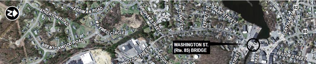
3 3 Route 85 Bridge Replacement


4 F.W. Beers, Hudson Town,


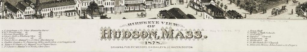
5 Looking Southwest Route 85 Bridge Replacement 5


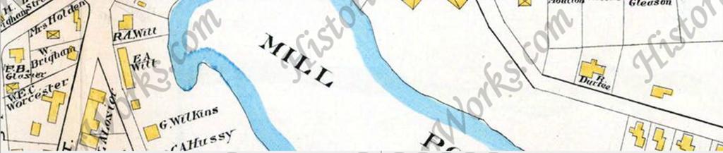
6 N George H. Walker & Co


7 Looking southwest, Bridge H at left, circa 1950s 7


8 8 Route 85 Bridge Replacement
9 BRIDGE CONSTRUCTION STAGING ALTERNATIVES ALTERNATIVE A : SINGLE LANE OPTION MAINTAINS SB TRAFFIC DETOURS NB TRAFFIC TEMPORARY PEDESTRIAN BRIDGE ADVANTAGES SAFER WORK ZONE SHORTER CONSTRUCTION DURATION BETTER FOR UTILITY RELOCATIONS LOWER CONSTRUCTION COST DISADVANTAGES NB TRAFFIC DETOURED FOR 9 MONTHS 9
10 BRIDGE CONSTRUCTION STAGING ALTERNATIVES ALTERNATIVE B : TEMPORARY BRIDGE OPTION MAINTAINS NB & SB TRAFFIC SINGLE LANE TEMPORARY BRIDGE TEMPORARY PEDESTRIAN BRIDGE ADVANTAGES MAINTAINS NB & SB TRAFFIC AT BRIDGE DISADVANTAGES HAZARDOUS WORK ZONE SHORT TERM NB detours LONGER CONSTRUCTION DURATION ADDITIONAL EARTH SUPPORTS DIFFICULT UTILITY RELOCATIONS HIGHER CONSTRUCTION COST 10

11 ALTERNATIVE A : SINGLE LANE OPTION 11

12 ALTERNATIVE A : SINGLE LANE OPTION 12

13 ALTERNATIVE A : SINGLE LANE OPTION 13
14 ALTERNATIVE A : SINGLE LANE OPTION 14
15 ALTERNATIVE B : TEMP. BRIDGE OPTION 15
16 ALTERNATIVE B : TEMP. BRIDGE OPTION 16

17 ALTERNATIVE B : TEMP. BRIDGE OPTION 17
18 ALTERNATIVE B : TEMP. BRIDGE OPTION 18
19 ALTERNATIVE B : TEMP. BRIDGE OPTION 19
20 ALTERNATIVE B : TEMP. BRIDGE OPTION 20
21 Construction Durations and Traffic Management Alternative A Single Lane First Season Stage 1 West side widening; Traffic maintained on existing bridge Second Season Stages 2 and 3 Northbound traffic detoured for approximately 9 months Alternative B Temporary Bridge First Season Stage 1 West side widening; Traffic maintained on existing bridge Second Season Stages 2 and 3 Northbound traffic detoured for 3 weeks during installation of temporary bridge Third Season Stages 4 and 5 Temporary bridge removed, all traffic maintained on new construction 21


22 ALTERNATIVES A & B : Route 85 Bridge Replacement PROPERTY OWNERSHIP AT OPTIONAL REMOTE LOCATION OF TEMP. PED. BRIDGE
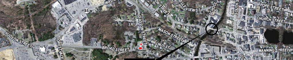

23 ROUTE 85 NORTHBOUND DETOUR ROUTES 23
24 24 Route 85 Bridge Replacement
25 TRAFFIC AND IMPACTS 25 IMPACTS AT BRIDGE SITE McDONALD S HARDWARE STORE GAS STATIONS / AUTO REPAIR SHOPS DETOUR ROUTES TRAFFIC STUDY / VOLUME PROJECTIONS SCHOOL STREET HOUGHTON STREET BROAD STREET INCREASED VOLUMES SIGNAL TIMING ADJUSTMENTS TEMPORARY SIGNING EMERGENCY PRE-EMPTION AT SIGNALS AT SHOPPING PLAZA ACCESS / EGRESS FIRE / POLICE / AMBULANCE EMERGENCY ROUTES SCHOOLS / SCHOOL BUS ROUTES EFFECTS OF CONSTRUCTION AND THE DETOUR ROUTES
26 HUDSON CONSTRUCTION STAGING ALTERNATIVES ALTERNATIVE A - SINGLE LANE OPTION ADVANTAGES SAFER WORK ZONE REDUCED NUMBER OF CONSTRUCTION STAGES LESS TIME FOR DEMOLITION LESS TIME TO BUILD SHORTER CONSTRUCTION DURATION [2 YEARS] BETTER SUITS UTILITY RELOCATIONS COSTS LESS [$2.5M~$1M LESS] STAGE 1 CONSTRUCTION / HOUGHTON ST. COMPLETION DISADVANTAGES ROUTE 85 NB TRAFFIC IS DETOURED DETOUR DURATION [9 MONTHS] Route 85 Bridge Replacement 26
27 HUDSON CONSTRUCTION STAGING ALTERNATIVES ALTERNATIVE B TEMPORARY BRIDGE OPTION ADVANTAGES PROVIDES FOR NB & SB TRAFFIC AT BRIDGE STAGE 1 CONSTRUCTION / HOUGHTON ST. COMPLETION Route 85 Bridge Replacement DISADVANTAGES HAZARDOUS WORK ZONE BETWEEN 2 LANES OF TRAFFIC WILL REQUIRE SHORT TERM NB DETOURS [3 WEEKS FOR TEMPORARY BRIDGE] INCREASED NUMBER OF CONSTRUCTION STAGES ADDITIONAL INSTALLATION & REMOVAL OF EARTH SUPPORTS MORE TIME FOR DEMOLITION WITH INCREASED LEVEL OF DIFFICULTY MORE TIME TO BUILD LONGER CONSTRUCTION DURATION [3 YEARS] MORE DIFFICULT TO RELOCATE UTILITIES COSTS MORE [$3.5M] 27
28 RECOMMENDATIONS/CONCLUSIONS MASSDOT PREFERS CONSTRUCTION STAGING ALTERNATIVE A QUESTIONS (???) CONTACT INFO: GREG STEFANO JACOBS GREG.STEFANO@JACOBS.COM MAURY TAYARANTI MASSDOT MORTEZA.TAYARANTI@DOT.STATE.MA.US 28
I-405 Sepulveda Pass Improvements Project
 I-405 Sepulveda Pass Improvements Project Community Meeting November 15, 2012 1 Wilshire Segment Overview of Wilshire Segment There are a total of 23 bridges being constructed on this project; almost half
I-84 Hartford Project Public Advisory Committee Meeting #19. March 28, 2019
 I-84 Hartford Project Public Advisory Committee Meeting #19 March 28, 2019 Meeting Agenda 1. Welcome / Introduction of New Members (5 min) 2. Construction Staging (50 min) 3. Environmental Documentation
Click to edit Master text styles
 I-405 Sepulveda Pass Improvements Project Quarterly Community Meeting November 17, 2011 1 Wilshire Segment 2 Quarterly Community Meetings 2012 Month Meeting(s) February 16 May 17 Quarterly Quarterly August
I-405 Sepulveda Pass Improvements Project
 I-405 Sepulveda Pass Improvements Project 26, 2012 Click to edit Master title January style Community Advisory Committee 1 Community Meeting Schedule for 2012 26-Jan CAC, Final Meeting Feb 22-Mar Community
US 67 WIDENING PROJECT
 US 67 WIDENING PROJECT From Belt Line Rd. to I-20 History & Background The US 67 improvements from Belt Line Rd to I-20 were originally part of TxDOT s Southern Gateway project, studied as part of the
SOUTH ACCESS TO THE GOLDEN GATE BRIDGE DOYLE DRIVE DOYLE DRIVE. Doyle Drive Presentation Golden Gate Bridge Board Meeting July 24, 2009
 DOYLE DRIVE Doyle Drive Presentation Golden Gate Bridge Board Meeting July 24, 2009 Presentation Overview Introduction Project Acceleration Construction Contracts Construction Activities Lane and Road
IMPROVEMENT CONCEPTS
 IMPROVEMENT CONCEPTS for the South Novato Transit Hub Study Prepared by: January 11, 2010 DKS Associates With Wilbur Smith Associates IMPROVEMENT CONCEPTS Chapter 1: Introduction 1. INTRODUCTION The strategic
30-Day Look Ahead Summary August 2011
 Wilshire Segment 30-Day Look Ahead Summary August 2011 DWP and SCE Utility Relocation Sepulveda reduced to one lane in each direction, Constitution to Ohio, 9pm to 6am Westbound Wilshire reduced to one
Service Planning Open House
 Service Planning Open House Presentation to Community RTA Board Room July 17, 2018 575 EYES See Something, Text Something Transit App RTA CLE Mobile Ticketing Bus Stop Consolidation/Safety Improvement
4.2 Series Station Option Description
 4.2 Series Station Option Description The series station proposal features a new set of side platforms constructed approximately 250 feet north of the existing platforms. The two new platforms would extend
CITY OF BEVERLY HILLS STAFF REPORT
 Meeting Date: July 7, 2011 To: From: Subject: CITY OF BEVERLY HILLS STAFF REPORT Honorable Mayor & City Council Pamela Mottice Muller, Director of Emergency Management 405 Closure Attachments: 1. 1-405
Regulatory Signs in Nomenclature Order
 Regulatory Signs in Nomenclature Order Nomenclature Description Sizes (mm x mm) R 1-1 STOP 600x600 750x750 900x900 1200x1200 R 1-1A RIGHT LANE KEEP MOVING 600x750 750x900 R 1-1B OPPOSING TRAFFIC DOES NOT
Purple Line Extension, Section 2 Southern California Edison, Phase I
 Purple Line Extension, Section 2 Southern California Edison, Phase I 1 Agenda Advance Utility Relocation (AUR) Schedule Southern California Edison (SCE) overview Street Impacts Sunday work: 10am-6pm Left
Existing Conditions Belmont Circle Bourne, MA. Belmont Circle Improvements
 Existing Conditions Belmont Circle Bourne, MA Speakers Pam Haznar, MassDOT Ed Hollingshead, Fay Spofford & Thorndike Heather Ostertog, Fay, Spofford & Thorndike Goals for Group Local Knowledge Work through
Corridor Management Committee. March 7, 2012
 Corridor Management Committee March 7, 2012 2 Today s Topics SWLRT Project Office Update Engineering Services Procurement Update Legislative Leadership Tour Annual New Starts Report Update on Proposed
CAPCOG TRAFFIC SIGNS, POSTS & CONTROL DEVICES
 CAPCOG 2018-19 TRAFFIC SIGNS, POSTS & CONTROL DEVICES Ratified 3/19/18 Winning bid is bold and highlighted. Ordering information is at the end of the document Contract Term April 1, 2018 to March 31, 2019
Greater Cleveland Regional Transit Authority. Bus Stop Design Guidelines
 Greater Cleveland Regional Transit Authority Bus Stop Design Guidelines Contents Purpose... I Bus Stop Design & Location... 1 Bus Stop Planning... 1 Bus Stop Safety & Consolidation... 1 As Needed Basis...
Public Meeting: Metropolitan Washington Airports Authority (MWAA) TNC (Transportation Network Company) Lot on S. Eads Street
 TNC (Transportation Network Company) Lot on S. Eads Street") Public Meeting: Metropolitan Washington Airports Authority (MWAA) TNC (Transportation Network Company) Lot on S. Eads Street Department of Environmental Services, Transportation Division Sept. 27, 2018
Public Meeting: Metropolitan Washington Airports Authority (MWAA) TNC (Transportation Network Company) Lot on S. Eads Street Department of Environmental Services, Transportation Division Sept. 27, 2018
New Jersey Turnpike Authority Interchange 6 to 9 Widening Program
 New Jersey Turnpike Authority Interchange 6 to 9 Widening Program Tuesday, September 18, 2007 Public Hearings: Time: 5:00 PM - 8:00 PM Wednesday, September 19, 2007 Senior Center 3 Municipal Drive Bordentown,
Countdown to the Closure Extended 53-Hour Closure of I-405 Freeway Between U.S. 101 and I-10 Planned in Mid-July for Mulholland Bridge Demolition
 Countdown to the Closure Extended 3-Hour Closure of I-40 Freeway Between U.S. 0 and I-0 Planned in Mid-July for Mulholland Bridge Demolition Work Los Angeles, Calif. Plan Ahead, Avoid The Area, Or Stay
Brent Spence Bridge Design Exceptions - Alternative I
 s - Alternative I ITERCHAGE umber Existing Reason(s) For Potential Impact(s) to Eliminate s Potential Mitigation Solutions CURVE O. 5 PI Sta. 24+98.87 Y 1 57 mph (60) 526' (570') 44 mph The line of sight
Project Description: Georgia Department of Transportation Public Information Open House Handout PI#(s): , County: Muscogee
: , County: Muscogee") Why We Are Here: GDOT s Transportation Improvement Act (TIA) Office, the City of Columbus, and the project delivery team are here this evening to display and answer questions concerning the proposed roadway
Why We Are Here: GDOT s Transportation Improvement Act (TIA) Office, the City of Columbus, and the project delivery team are here this evening to display and answer questions concerning the proposed roadway
Maryland Gets to Work
 I-695/Leeds Avenue Interchange Reconstruction Baltimore County Reconstruction of the I-695/Leeds Avenue interchange including replacing the I-695 Inner Loop bridges over Benson Avenue, Amtrak s Northeast
Purple Line Extension, Section 2 Southern California Edison, Phase I June 7, 2017
 Purple Line Extension, Section 2 Southern California Edison, Phase I June 7, 2017 Agenda Advance Utility Relocation (AUR) Schedule Southern California Edison (SCE) overview Street Impacts Sunday work:
Janice Fortunato Senior Director Business Partnerships
 Janice Fortunato Senior Director Business Partnerships What are Megaprojects? They are large-scale projects distinguished by cost, complexity and the potential impact on the community. Collectively, these
W&OD TRAIL BRIDGE OVER LEE HIGHWAY I-66 EASTBOUND WIDENING INSIDE THE BELTWAY FROM THE DULLES CONNECTOR ROAD (ROUTE 267) TO FAIRFAX DRIVE (ROUTE 237)
 TO FAIRFAX DRIVE (ROUTE 237)") W&OD TRAIL BRIDGE OVER LEE HIGHWAY A COMPONENT OF THE I-66 EASTBOUND WIDENING INSIDE THE BELTWAY FROM THE DULLES CONNECTOR ROAD (ROUTE 267) TO FAIRFAX DRIVE (ROUTE 237) October 11, 2018 Bill Cuttler, PE
W&OD TRAIL BRIDGE OVER LEE HIGHWAY A COMPONENT OF THE I-66 EASTBOUND WIDENING INSIDE THE BELTWAY FROM THE DULLES CONNECTOR ROAD (ROUTE 267) TO FAIRFAX DRIVE (ROUTE 237) October 11, 2018 Bill Cuttler, PE
BID SUMMARY SHEET PUBLIC BID NO TRAFFIC WARNING/STREET SIGNS AND SUPPLIES BIDS RECEIVED: MARCH 29, 2016
 1 EACH R1-1 - 30" X 30" Stop Sign $22.90 $23.62 2 EACH R1-2 - 36" x 36" x 36" Yield Sign $16.29 $18.00 3 EACH R1-2 - 24" x 24" x 24" Yield Sign $12.54 $10.03 4 EACH R1-6a-Ped X-ing $22.80 $43.80 5 EACH
Chapter 17 TRAFFIC AND VEHICLES. Adoption of Uniform Rules of the Road. Temporary Traffic Regulations.
 Chapter 17 TRAFFIC AND VEHICLES Article I. Article II. Article III. In General. Section 17.1 Adoption of Uniform Rules of the Road. Section 17.2 Temporary Traffic Regulations. Section 17.3 Traffic Speed,
Danger Zones. Correct Mirror Adjustment. Outside Left and Right Side Flat Mirrors
 Danger Zones The danger zone is the area on all sides of the bus where children are in the most danger of being hit, either by another vehicle or their own bus. The danger zones may extend as much as 30
Strategies to keep people and goods moving in and through Seattle
 Strategies to keep people and goods moving in and through Seattle SR 99 Closure and the Seattle Squeeze 2018-2024 DON Information Session Department of Transportation Delridge Community Center November
June WASHINGTON STATE DEPARTMENT OF TRANSPORTATION Alaskan Way Viaduct and Seawall Replacement Program Seattle, Washington
 DESIGN DEVIATION NOs. 1 & 2 Horizontal Stopping Sight Distance and Shoulder Width Reduction SR 99 S. Holgate St to S. King St. Viaduct Replacement Stage 2 MP 29.89 TO MP 30.78 XL-3237 PIN-809936D June
I-405 Sepulveda Pass Improvements Project. Community Advisory Committee July 28, 2011
 I-405 Sepulveda Pass Improvements Project Community Advisory Committee July 28, 2011 1 Wilshire Segment 2 Wilshire Segment (National to Waterford) Ramp and Wall Construction at Sepulveda/Wilshire Intersection
AVERAGE DELAY PER VEHICLE EXISTING CONDITIONS AND NO BUILD ALTERNATIVE
 AVERAGE DELAY PER VEHICLE EXISTING CONDITIONS AND NO BUILD ALTERNATIVE EXISTING CONDITIONS (1) NO BUILD ALTERNATIVE () Compared to existing conditions Peak Hour/Train Scenario No Train 1 With Train No
City of Houston Fondren Road Paving and Drainage
 City of Houston Fondren Road Paving and Drainage From Braeswood Boulevard to Creekbend Drive TRC Meeting March 2016 Location and Vicinity Maps City Council District K Key Map 530 Z, 530 Y Land Use Commercial
I-90 ALLSTON INTERCHANGE A MULTIMODAL TRANSPORTATION PROJECT PUBLIC INFORMATION MEETING
 I-90 ALLSTON INTERCHANGE A MULTIMODAL TRANSPORTATION PROJECT PUBLIC INFORMATION MEETING DECEMBER 8, 2015 JACKSON MANN COMMUNITY CENTER Meeting Agenda Welcome & Introductions Introduce Concept 3K West Station
Figure 1 Map of intersection of SR 44 (Ravenna Rd) and Butternut Rd
 and Butternut Rd") Abbreviated Study District: 12 County: Geauga Route: SR 44 Section: 1.58 GEA 44 1.58 213 HSP # 47 (Rural Intersection) Prepared April 23, 215 By Bryan Emery Existing Conditions This study contains the
Abbreviated Study District: 12 County: Geauga Route: SR 44 Section: 1.58 GEA 44 1.58 213 HSP # 47 (Rural Intersection) Prepared April 23, 215 By Bryan Emery Existing Conditions This study contains the
However, due to the location, all garage parkers will need to continue to use the South end garage for entrance and exit.
 We apologize for any inconvenience that this construction may cause and appreciate your patience while we work hard to improve The Crescent for our customers. Effective Tuesday, July 28 Shoring for the
Connect. Thrive. Develop. KC Streetcar Riverfront Extension & Multi-Modal Feasibility Study
 Connect. Thrive. Develop. Why go to the Riverfront? KC Streetcar is a proven catalyst for development & connecting people to Downtown. < $2 billion in adjacent development: new businesses, hotels, apartments
BID SUMMARY SHEET CONTRACT NO
 1 EACH R1-1 - 30" X 30" Stop Sign $23.61 $23.58 2 EACH R1-2 - 36" x 36" x 36" Yield Sign $16.36 $16.61 3 EACH R1-2 - 24" x 24" x 24" Yield Sign $12.55 $13.24 4 EACH R3-1 - 12" x 6" 4-Way $2.76 $1.98 5
RTE. 1 at RTE. 637 & RTE. 639
 INTERSECTION SAFETY STUDY Prepared for: Virginia Department of Transportation Central Region Operations Traffic Engineering (UPC #81378, TO 12-092) DAVENPORT Project Number: 13-368 / /2014 RTE. 1 at RTE.
South Gloucestershire Challenge Fund and Cycle Ambition Fund
 South Gloucestershire Challenge Fund and Cycle Ambition Fund The Challenge Fund A4174 scheme is coordinated and delivered by South Gloucestershire Council who were awarded 14 million pounds from the Department
FREQUENTLY ASKED QUESTIONS
 THE PROJECT Last updated on 2/19/16 FREQUENTLY ASKED QUESTIONS What s happening on Highway 169? The Minnesota Department of Transportation (MnDOT) is planning to rebuild and repair the infrastructure on
MERIVALE PRIORITY SQUARE 2852 MERIVALE ROAD CITY OF OTTAWA TRANSPORTATION BRIEF. Prepared for: ONT Inc. 25 Winding Way Nepean, Ontario K2C 3H1
 MERIVALE PRIORITY SQUARE 2852 MERIVALE ROAD CITY OF OTTAWA TRANSPORTATION BRIEF Prepared for: 2190986ONT Inc. 25 Winding Way Nepean, Ontario K2C 3H1 October 6, 2010 110-502 Report_1.doc D. J. Halpenny
Purple Line Extension Section 1 Construction Community Meeting April 19, 2018
 Purple Line Extension Section 1 Construction Community Meeting April 19, 2018 1 Agenda Section 1 MOW 64 Facility Project Construction Updates: Wilshire/Western Wilshire/La Brea Wilshire/Fairfax Wilshire/La
H/Benning Phase 2 Construction. December 17, 2012
 H/Benning Phase 2 Construction December 17, 2012 Agenda I. Construction Schedule II. Elements of Construction III. Policy and Enforcement IV. Ongoing Communication Construction Schedule Phase 1 (completed
EXECUTIVE SUMMARY. The valet operation, service area, and drop-off lanes provided will be adequate Page i
 EXECUTIVE SUMMARY MacKenzie Engineering and Planning, Inc. performed an analysis of the traffic impacts resulting from the proposed project site located at 25 SE 4th Avenue, Delray Beach, Florida (PCN
Brainstormed Solutions - Passenger
 1-1a Air / Exand: Expand capacity (runway lengths) at BG airport (LOW) find solution! 1-1b Air / fuel: Improve fuel availabilty and reduce cost (LOW) Sound Walls X X X Reduce scatter lighting - more focused
Traffic Signal Timing Diamond Operation. Innovation for better mobility
 Traffic Signal Timing Diamond Operation Classic Diamond Interchange Page 2 2 What is a Diamond? Page 3 3 What is a Diamond? (Signal Terms) Two closely spaced signalized intersections of an arterial with
Detroit River International Crossing Study. The Best Alternative At This Time For Being Considered The Preferred Alternative
 Detroit River International Crossing Study The Best Alternative At This Time For Being Considered The Preferred Alternative Build Alternatives Included in DRIC DEIS Alternative Interchange Plaza Crossing
Central Park Drives Traffic Management Overview
 Central Park Drives Traffic Management Overview Spring 2015 New York City Department of Transportation Existing Traffic Management From Labor Day thru Last Day of NYC Public School: 8-10 AM weekdays (Southbound)
The Corporation of Haldimand County
 Consolidation August 1, 2014 This consolidation is prepared for convenience only. For accurate reference, recourse should be had to the Original By-law and approved corresponding amendments. The Corporation
FREQUENTLY ASKED QUESTIONS
 THE PROJECT Last updated on 9/8/16 FREQUENTLY ASKED QUESTIONS What s happening on Highway 169? The Minnesota Department of Transportation (MnDOT) is planning to rebuild and repair the infrastructure on
TRAFFIC-CALMING SOLUTIONS A SURVEY OF SAFETY PROFESSIONALS
 TRAFFIC-CALMING SOLUTIONS A SURVEY OF SAFETY PROFESSIONALS SURVEY TRAFFIC CALMING OPTIONS In January 27, over 1 traffic engineers, police officers and safety professionals from around the United States
Title 10 VEHICLES AND TRAFFIC
 Chapter 10 10-0 Title 10 VEHICLES AND TRAFFIC Chapters: 10.04 State Law Adopted 10.08 Accident Reports 10.12 Traffic Signs and Signals 10.13 School Buses 10.16 Speed Limits 10.20 Through Highways 10.22
Speed Limit and Safety Nexus Studies for Automated Enforcement Locations in the District of Columbia 400 Block 14th Street SW
 Speed Limit and Safety Nexus Studies for Automated Enforcement Locations in the District of Columbia 4 Block 4th Street SW Study Area and Location District PSA Ward ANC Phase Description 27 6 6D Existing
To: Operations & Scheduling Committee Date: 09/21/2017. From: Ruby Horta, Director of Planning & Marketing Reviewed by:
 To: Operations & Scheduling Committee Date: 09/21/2017 From: Ruby Horta, Director of Planning & Marketing Reviewed by: SUBJECT: Walnut Creek Transit Village Background: Construction at Walnut Creek BART
IH 35 FEASIBILITY STUDY
 IH 35 FEASIBILITY STUDY COOKE COUNTY, TEXAS February 1, 2007 Prepared by: Carter & Burgess, Inc. For: The Wichita Falls District of the Texas Department of Transportation INDEX I. INTRODUCTION. 3 II. PURPOSE
VIADUCT LOCATION STUDY. October 19, 2009
 VIADUCT LOCATION STUDY October 19, 2009 Background Information Traffic Study Alternative Evaluation Public Involvement Preferred Concept Next Steps Evaluate alternatives for the location of a viaduct to
TRAFFIC PARKING ANALYSIS
 TRAFFIC PARKING ANALYSIS NAPA FLEA MARKET COUNTY OF NAPA Prepared for: Tom Harding Napa-Vallejo Flea Market 33 Kelly Road American Canyon, CA 9453 Prepared by: 166 Olympic Boulevard, Suite 21 Walnut Creek,
Appendix J Traffic Impact Study
 MRI May 2012 Appendix J Traffic Impact Study Level 2 Traffic Assessment Limited Impact Review Appendix J [This page was left blank intentionally.] www.sgm-inc.com Figure 1. Site Driveway and Trail Crossing
10-10 TEMPORARY PARKING PROHIBITION FOR SNOW PLOWING AND REMOVAL. Brighton Avenue Both Between Route NJ 71 (Norwood Avenue) and Railroad Avenue.
 and Railroad Avenue.") 10-10 TEMPORARY PARKING PROHIBITION FOR SNOW PLOWING AND REMOVAL Name of Street Sides Location Brighton Avenue Both Between Route NJ 71 (Norwood Avenue) and Railroad Avenue. Campbell Court Both Entire
10-10 TEMPORARY PARKING PROHIBITION FOR SNOW PLOWING AND REMOVAL Name of Street Sides Location Brighton Avenue Both Between Route NJ 71 (Norwood Avenue) and Railroad Avenue. Campbell Court Both Entire
I-225 Rail Line Iliff and Florida Stations Information Meeting
 I-225 Rail Line Iliff and Florida Stations Information Meeting May 15, 2013 FasTracks and I-225 Rail Line Update Chuck Culig I-225 Rail Line Project Manager Chris Hinton I-225 Rail Line Deputy Project
Construction starts this summer on the second and final phase of the Interstate 95 Cottman/
 I-news 2012 Stay current with construction at the Cottman Avenue and Girard Avenue interchanges at www.revive.com. Final Half of Cottman Interchange Project Starts Construction starts this summer on the
SOUTHERN GATEWAY. Transportation and Trinity River Project Committee 11 May 2015
 SOUTHERN GATEWAY Transportation and Trinity River Project Committee 11 May 2015 Southern Gateway Project History Began in 2001 as a Major Investment Study [ MIS ], Schematic, and Environmental Assessment
MEMORANDUM TERESA MCCLISH, DIRECTOR OF COMMUNITY DEVELOPMENT
 MEMORANDUM TO: FROM: BY: CITY COUNCIL TERESA MCCLISH, DIRECTOR OF COMMUNITY DEVELOPMENT MATTHEW DOWNING, PLANNING MANAGER SUBJECT: CONSIDERATION OF TEMPORARY USE PERMIT CASE NO. 18-017; AUTHORIZING HALLOWEEN
Location Concept Plan Amendment Recommendation Approved 2011 Concept Plan
 Valley Line West LRT Concept Plan Recommended Amendments Lewis Farms LRT Terminus Site Location Concept Plan Amendment Recommendation Approved 2011 Concept Plan Lewis Farms LRT terminus site, 87 Avenue/West
RICHMOND OAKS HEALTH CENTRE 6265 PERTH STREET OTTAWA, ONTARIO TRANSPORTATION BRIEF. Prepared for: Guycoki (Eastern) Limited.
 Limited.") RICHMOND OAKS HEALTH CENTRE 6265 PERTH STREET OTTAWA, ONTARIO TRANSPORTATION BRIEF Prepared for: Guycoki (Eastern) Limited June 16, 2016 116-638 Brief_1.doc D. J. Halpenny & Associates Ltd. Consulting
RICHMOND OAKS HEALTH CENTRE 6265 PERTH STREET OTTAWA, ONTARIO TRANSPORTATION BRIEF Prepared for: Guycoki (Eastern) Limited June 16, 2016 116-638 Brief_1.doc D. J. Halpenny & Associates Ltd. Consulting
Public Information Packet FY Fargo-Moorhead Metropolitan Transportation Improvement Program (TIP)
") Public Information Packet FY - Fargo-Moorhead Metropolitan Transportation Improvement Program (TIP) Comment Form Annual Element TIP Projects - TIP Projects Year - Metropolitan Transportation Improvement
Public Information Packet FY - Fargo-Moorhead Metropolitan Transportation Improvement Program (TIP) Comment Form Annual Element TIP Projects - TIP Projects Year - Metropolitan Transportation Improvement
Proposed Inn at Bellefield Traffic Impact Assessment
 Proposed Inn at Bellefield Traffic Impact Assessment Town of Hyde Park Dutchess County, New York Prepared for: T-Rex Hyde Park Owner LLC 500 Mamroneck Avenue, Suite 300 Harrison, NY 10528 June 21, 2017
RESTRICTIONS ON PARKING; POSTED LIMITATIONS.
 CHAPTER 3 Parking Regulations 9-3-1 Restrictions on Parking; Posted Limitations 9-3-2 Parking Restrictions During Street Maintenance or Temporary Snow Removal 9-3-3 Stopping or Parking Prohibited in Certain
2.1.5 Traffic and Circulation. Table Level of Service Criteria for Highway Segment Regulatory Setting Affected Environment
 2.1.5 Traffic and Circulation This section addresses the potential impacts to traffic and circulation associated with construction and long-term operation of the proposed project. The traffic and circulation
Summary of the Alcoa Highway Redevelopment Project
 Appendix B Summary of the Alcoa Highway Redevelopment Project By Marcia Finfer, October 2009 The Timberlake community, along with numerous other concerned citizen groups (including the Lakemoor Hills community)
Brigham City 1200 West Box Elder Creek Bridge - Widening Project Type Reconstruction
 Brigham City 1200 West Box Elder Creek Bridge - Widening Project Type Reconstruction 550 North to 650 North $ 1,750,000 $ 1,582,113 To widen an existing bridge on 1200 West over Box Elder Creek that will
Over-Dimensional Vehicle Restriction Study for US 129 in TN
 Over-Dimensional Vehicle Restriction Study for US 129 in TN July 30,2015 TDOT Region 1 US 129 Location Map US 129 Topography and Scenery Operational and Safety Study August 2014, US129 Operational and
Project Status Update January 2017
 Project Status Update January 2017 1 What is the Purple Line? A new 16 mile east-west light rail line Operates mostly on the surface with 21 stations Connects New Carrollton in Prince George s County and
Tunney s Pasture to Dominion Station Traffic and Transit Detours. April 4, 2017 C. Wheeler/ C. Swail
 Tunney s Pasture to Dominion Station Traffic and Transit Detours April 4, 2017 C. Wheeler/ C. Swail Purpose of Presentation Outline key principles for traffic and transit management Implementation strategies
Project Working Group Meeting #5
 September 17, 2013 Project Working Group Meeting #5 1 September 17, 2013 www.i-80will.com Meeting Purpose Project update Discuss Range of Alternatives Discuss next steps 2 September 17, 2013 www.i-80will.com
Key words School zones, multi-lane road, static sign, enhanced sign, variable speed limit sign, vehicle activated sign.
 Queensland multi-lane school zone trial Rohit Singh Senior Engineer (Road Safety Systems), Safer Roads Unit Department of Transport and Main Roads, Queensland Contact: Phone: (07) 32534177 Fax: (07) 32534110
EXCEPTION TO STANDARDS REPORT
 EXCEPTION TO STANDARDS REPORT PROJECT DESCRIPTION AND NEED The project is located in Section 6, Township 23 North, Range 9 East and Section 31 Township 24 North, Range 9 East, in the Town of Stockton,
Algo Traffic and the Tuscaloosa RTMC. Chris Sewell, P.E. ITS Operations Manager ALDOT West Central Region
 Algo Traffic and the Tuscaloosa RTMC Chris Sewell, P.E. ITS Operations Manager ALDOT West Central Region Outline Partnerships with the University of Alabama Tuscaloosa Traffic Management Center Algo Traffic
Troost Corridor Transit Study
 Troost Corridor Transit Study May 23, 2007 Kansas City Area Transportation Authority Agenda Welcome Troost Corridor Planning Study Public participation What is MAX? Survey of Troost Riders Proposed Transit
CY 2013 and CY 2014 NOVA District Advertisement Schedule Design-Bid-Build
 1 2013 Planned s System Route UPC Category Locality Project Description 395 98836 Bridge Arlington Clean/Re-Paint 7 Bridges I-395 Corridor Arlington/Alexandria 4/9/2013 $ 3.45 HOT Lanes Bicycle/Pedestrian
MGM SPRINGFIELD OFF-SITE MITIGATION - 9/25/17 TO 10/6/17 WORK HOURS: 7:00 AM TO 3:30 PM
 1 A Dwight Street & I-291 Off Ramp 2 B Locust Street & Mill Street No work anticipated 3 B Main Street & East Columbus Avenue No work anticipated 4 C State Street & St. James Avenue No work anticipated
TRAFFIC IMPACT STUDY. USD #497 Warehouse and Bus Site
 TRAFFIC IMPACT STUDY for USD #497 Warehouse and Bus Site Prepared by: Jason Hoskinson, PE, PTOE BG Project No. 16-12L July 8, 216 145 Wakarusa Drive Lawrence, Kansas 6649 T: 785.749.4474 F: 785.749.734
Study Area and Location District PSA Ward ANC Phase Description C Proposed 2600 Block Lincoln Road Northeast Northbound
 Speed Limit and Safety Nexus Studies for Automated Enforcement Locations in the District of Columbia 2600 Block Lincoln Road NE Study Area and Location District PSA Ward ANC Phase Description 5 502 5 5C
Update on Transportation Activities in Fairfax County
 Update on Transportation Activities in Fairfax County Transportation Roundtable Dulles Area Transportation Association June 13, 2018 Tom Biesiadny, Director Fairfax County Continuing Project Implementation
Traffic Feasibility Study
 Traffic Feasibility Study Town Center South Robbinsville Township, Mercer County, New Jersey December 19, 2017 Prepared For Robbinsville Township Department of Community Development 2298 Route 33 Robbinsville,
886 March Road McDonald's Transportation Study
 McDonald's Restaurants of Canada Limited March 2013 886 March Road McDonald's Transportation Study Submitted by: HDR Corporation 100 York Boulevard, Suite 300 Richmond Hill, ON L4B 1J8 (905) 882-4100 www.hdrinc.com
Traffic Impact Analysis West Street Garden Plots Improvements and DuPage River Park Garden Plots Development Naperville, Illinois
 Traffic Impact Analysis West Street Garden Plots Improvements and DuPage River Park Garden Plots Development Naperville, Illinois Submitted by April 9, 2009 Introduction Kenig, Lindgren, O Hara, Aboona,
I I I I I I I SUMMARY REPORT ON HEALTH SCIENCES PARKING RAMP AND RELATED CONNECTOR ROADS UNIVERSITY OF MINNESOTA, MINNEAPOLIS.
 SUMMARY REPORT ON HEALTH SCENCES PARKNG RAMP AND RELATED CONNECTOR ROADS UNVERSTY OF MNNESOTA, MNNEAPOLS Prepared by The Architects Collaborative, nc. With assistance from De Leuw, Cather and Company Traffi
Chapter 11 Route Window NE10 Gidea Park station. Transport for London
 Chapter 11 Route Window NE10 Gidea Park station Transport GIDEA PARK STATION 11 Route Window NE10 Gidea Park station Transport Introduction 11.1 The construction activities in this route window are associated
Construction Staging Area 4 Avenue Road
 REPORT FOR ACTION Construction Staging Area 4 Avenue Road Date: September 27, 2017 To: Toronto and East York Community Council From: Acting Director, Transportation Services, Toronto and East York District
VEHICLE NO.1- Your Vehicle. Began From. License Plate # (Street, Highway, Mile Marker, Terminal or Other Landmark) Near At VEHICLE NO.2.
 Near At VEHICLE NO.2.") Bates College Automobile Accident Report Please notify Security immediately after an incident. Complete and submit this report within 24 hours of the accident to Adam Mayo in Security. Please fill out
Bates College Automobile Accident Report Please notify Security immediately after an incident. Complete and submit this report within 24 hours of the accident to Adam Mayo in Security. Please fill out
vision42
 vision42 www.vision42.org vision42 auto-free light rail boulevard for 42nd Street Roxanne Warren, AIA, Chair George Haikalis, ASCE, Co-Chair Institute for Rational Urban Mobility,Inc. www.vision42.org
Mid-Coast Corridor Transit Project
 San Diego Transportation Development Association Mid Coast Construction Update June 11, 2018 Mid-Coast Corridor Transit Project Mid-Coast Project 11-mile extension of Trolley Blue Line New LRT Infrastructure:
Bus Driver Maps & Information
 Bus Driver Maps & Information 1 P a g e Getting to the University of Idaho (Kibbie Dome) From the North (Coeur d Alene) Continue on Hwy 95 South to 3 rd Street, also known as Highway 8 (3 rd stoplight)
Pace Bus Depot Location Analysis
 Pace Bus Depot Location Analysis Key Notes 1. Options refer to conceptual sketches prepared by Kimley Horn. 2. The depot is assumed to accommodate Pace routes as they currently exist: 17 routes on the
Environmental Assessment Derry Road and Argentia Road Intersection
 Air and Noise Study Environmental Assessment Derry Road and Argentia Road Intersection Project 11-4295 City of Mississauga, Region of Peel October 17, 2014 1 Region of Peel Environmental Assessment for
Swift Green Line April 11, 2019
 Swift Green Line April 11, 2019 Overview Swift BRT Overview Swift Green Line Project Snohomish County Partnership Early Results Swift Washington s first BRT Overlay BRT Stations approx. 3/4-1 mile apart
APPENDIX B. Origin Destination Study Data
 APPENDIX B Origin Destination Study Data - TABLE OF CONTENTS - Page No. EXECUTIVE SUMMARY... 1 Map of the Study area with Site Locations... 2 Summary Table of Results for the TH 14 Corridor Study... 3