5.5 PARKING ENVIRONMENTAL SETTING. Henry Mayo Newhall Memorial Hospital Master Plan Environmental Impact Report
|
|
|
- Joleen Moore
- 5 years ago
- Views:
Transcription

1 Section 5.5 PARKING
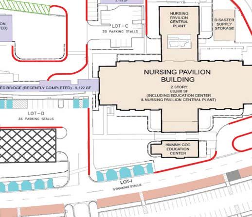
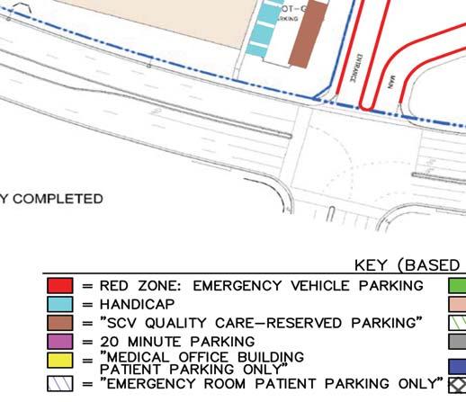
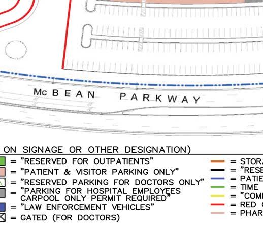
2 5.5 PARKING This section evaluates the impacts of the proposed project in regards to parking at the project site. This analysis summarizes the findings of the Parking Study Report, Henry Mayo Newhall Memorial Hospital Master Plan (Parking Study Report) prepared by Linscott, Law & Greenspan (LLG), dated May 19, For a detailed discussion of assumptions, calculations, and conclusions utilized in the parking analysis, refer to the Parking Study Report included in its entirety in Appendix K of this EIR ENVIRONMENTAL SETTING EXISTING PARKING CONDITIONS The existing (HMNMH) campus is located on a 30.4-acre site within the City of Santa Clarita, at McBean Parkway. Refer to Section 3.0, Project Description, for a detailed description of existing conditions at the site. As part of the Parking Study Report prepared for the proposed project, existing parking conditions at the project site were extensively inventoried for parking provisions, types and restrictions (typically by intended user group and designated by signage and/or pavement markings). As indicated on Exhibit 5.5-1, Existing Parking Layout, there are 12 parking space designation types (quotation marks indicate actual sign legends), and seven types of curb parking characteristics. Table 5.5-1, Existing Parking Supply, summarizes the number of marked spaces in each category. Table distinguishes between actual marked spaces in parking lots, space equivalency for drop off areas (these are located near the hospital main entry, and sometimes used for short-term parking), and on-street spaces along the curb of the internal ring road of the site. Where parking spaces are not explicitly marked along these curbs, the space count is estimated at 22 feet per vehicle. Based upon the comprehensive inventory of on-site spaces in service during the November 2007 field studies, the existing parking supply for the HMNMH totals 1,114 spaces, consisting of 968 spaces in surface lots, and 146 on-street spaces along the internal circulation roadways of the site. It is not unusual for space counts in large campus settings like that of the HMNMH Master Plan site to vary with time and among inventory sources. The City in previously released environmental documents has used an existing condition of 972 surface lot spaces for the site. In LLG s recent field study, they noted a small number of what had been and would likely be again parking spaces that were out of service due to construction activities. From LLG s field review, they concluded that four spaces from the City s prior reported inventory of 972 surface lot spaces are temporarily not in service (these are located in a small lot southwest of the ambulance entrance), but would be again once current construction activity ends, thus reconciling the variation between the City-reported total of 972 surface lot spaces and the 968 surface lot spaces inventoried by LLG. Draft September Parking
3 Table Existing Parking Supply Parking Inventory Category 1 Curb Lots Total SURFACE LOTS MARKED SPACES Unrestricted Regular Handicap Subtotal Restricted Medical Office Patients SVC Quality Care Reserved Parking 8 8 Patient and Visitor Parking Only Reserved for Outpatients Minute Parking 2 2 Reserved Parking for Doctors Only Gated (For Doctors) Parking for Hospital Employees Carpool Only Permit Required Emergency Room Patient Parking Only Red Zone: Emergency Vehicle Parking 4 4 Law Enforcement Vehicles 3 3 Subtotal SURFACE LOTS UNMARKED SPACES Drop-Off Subtotal Subtotal Surface Lots ON-STREET PARKING 2 Regular Yellow ( Commercial Delivery Zone ) 3 3 Green (Time Restricted) White (No Other Signage/Marking) 4 4 Pharmacy 20 Minute 2 2 Reserved Parking for Engineering Vehicles Only Subtotal 146 TOTAL FOR PROJECT SITE ,114 Source: Parking Study Report,, Linscott, Law & Greenspan, May 19, Based on signage or other designation. 2 Estimated at 22 feet per curb space. Note: Date of supply inventory was November 4, EXISTING PARKING DEMAND Parking Demand Surveys In order to determine the existing parking demand characteristics of the HMNMH, parking utilization surveys were performed on-site at various times throughout the days of Wednesday, November 7, 2007 and Thursday, November 8, Based on conversations with HMNMH representatives, Wednesdays and Thursdays were determined to be the most likely days to capture peak week-long representative data for hospital and medical office building (MOB) activity. Data provided by HMNMH indicate that November 7 and 8, 2007 were average to slightly greater than average when compared to annual averages for inpatient, outpatient, and emergency patients/visits to the facility. Draft September Parking


4 Source: Linscott Law and Greenspan; May 9, NOT TO SCALE 06/08 JN REVISED ENVIRONMENTAL IMPACT REPORT HENRY MAYO NEWHALL MEMORIAL HOSPITAL MASTER PLAN Existing Parking Layout Exhibit 5.5-1
5 This page intentionally left blank. Draft September Parking
6 For the purposes of the parking utilization surveys, the HMNMH project site was divided into six subareas (i.e., zones ); refer to Exhibit 5.5-2, Parking Subareas. All vehicles parked within each of the six subareas of the site (both in surface lots [whether in a marked space or not] and in onstreet parking) were counted at the top of every hour, beginning at 6:00 AM and ending at 8:00 PM. Table 5.5-2, Observed Parking Demand vs. Existing Supply, provides a comparison of demand observed during the utilization surveys versus existing on-site parking supply on an hour-by-hour basis. As shown in Table 5.5-2, observed parking demand throughout the site was consistently greater on Wednesday versus Thursday. The peak occurred at 11:00 AM on Wednesday with a site-wide parking demand of 1,051 spaces (921 in lots and 130 at the curb). Peak demand on Thursday (occurring at 11:00 AM, totaling 1,004 spaces) was approximately five percent less than Wednesday. With the exception of the 7:00 AM survey period, all Thursday demand values were higher than Wednesday on an hour-by-hour basis. Table also shows that the observed peak represented an overall 94 percent parking occupancy (calculated as a peak demand of 1,051 spaces versus a supply of 1,114 spaces), and resulted in a 63 space observed space surplus for the site. Figure 3-3 in Appendix K translates the parking demand values of Table to parking profiles for both Wednesday and Thursday by time-of-day, and compares those demands to a supply line at 1,114 spaces. The left margin of Figure 3-3 identifies the scale for actual demand (vehicles parked), while the right margin provides a scale for expressing observed demand as a percent of total supply. From Figure 3-3, it is evident that the mid- to late-morning hours have the greatest relative demand of the day, and on the day identified for this study, Wednesday, ran at greater than 90 percent of supply. Observed demand at mid-day and into the mid-afternoon hours fell just below 90 percent on the same peak day. Additional details regarding the survey results for the site by sub-area and for the combination of subareas that make up each zone are provided in Tables B-1 through B-14 in Appendix K. Table B-13 presents a detailed site-wide breakout of inventory by space type and the observed parking demand in each of those space groupings by time-of-day. As part of the parking utilization survey, the following characteristics were noted: Peak demand conditions are characterized by parking occupancies of 94 percent or greater in Zones 1, 2, 3, and 6. Demand in Zones 4 and 5 peaks at 68 percent. The demand variations among zones result from a combination of factors, including proximity to on-foot destination, space designations/allocations, and availability of attendant-assisted parking (the latter is provided in Zones 1 and 6 during potential peak demand periods, thus adding incrementally to the marked supply in those zones due attendant processing and staging of some arriving vehicles). Regardless of location, spaces explicitly reserved by signage for patients-only parking are fully occupied (100 percent) at peak times. Many other designated space groupings, ranging in size from a few to about 20 spaces, are also full. Draft September Parking
7 Table Observed Parking Demand vs. Existing Supply Wednesday (11/07/07) Thursday (11/08/07) HMNMH (Zones 1-6) HMNMH (Zones 1-6) Time Curb Lots Total Curb Lots Total 6:00 AM :00 AM :00 AM :00 AM , :00 AM , :00 AM * 1,051* 121* 883* 1,004* 12:00 PM 131* :00 PM :00 PM :00 PM :00 PM :00 PM :00 PM :00 PM :00 PM Peak Demand , ,004 Supply , ,114 Percent Occupancy 90% 95% 94% 83% 91% 90% Surplus (+) or Deficiency (-) Peak Day (Wednesday, 11/07/07) Peak Demand ,051 Supply ,114 Percent Occupancy 90% 95% 94% Surplus (+) or Deficiency (-) Source: Parking Study Report,, Linscott, Law & Greenspan, May 19, * Corresponds to peak demand. Text in italics corresponds to peak demand for the two-day survey. At the peak, the 633 regular (otherwise unrestricted) spaces have a combined occupancy of 103 percent. The overage demand occurs entirely in Zone 6, and is facilitated by attendant-assisted parking operations. During peak demand times, attendants will take a visitor s vehicle and stage that vehicle in an aisle until a marked space becomes available. This adds to the functional supply within the Zone 6 lot during those peak times. Among the least used spaces by category, the 74 handicap spaces on the site have a peak demand of 48 vehicles, for a 65 percent occupancy level. Provision of these spaces is required by both State and Federal law, and thus their supply amount cannot be adjusted or rebalanced. The 35 percent surplus (26 spaces) in the handicap category, when combined with other site demand characteristics, tends to improve the overall parking occupancy percentage. Without handicap demand or spaces included, the site parking occupancy grows to 96 percent, versus the 94 percent indicated within Table It is clear that on-street curb spaces play an important role in the parking balance at the site. These clearly are not spaces of last resort, and their use ramps up early in the day, indicated by a demand of 95 spaces at 8:00 AM and 121 spaces at 9:00 AM, versus a daylong peak of 131 spaces. Draft September Parking


8 Source: Linscott Law and Greenspan; May 19, NOT TO SCALE 06/08 JN REVISED ENVIRONMENTAL IMPACT REPORT HENRY MAYO NEWHALL MEMORIAL HOSPITAL MASTER PLAN Parking Subareas Exhibit 5.5-2
9 This page intentionally left blank. Draft September Parking
10 Existing Parking Influencers Ambulatory Care Center/Valencia Medical Office Building The Ambulatory Care Center (ACC) and the Valencia Medical Office Building (MOB) exist on a separate parcel to the north of the project site (north of Avenida Navarre). These buildings are not a part of the existing HMNMH project site, but are potential existing parking influencers of demand for the proposed project. On that basis, the Parking Study Report included an analysis of the ACC/Valencia MOB site concurrently with the HMNMH. The ACC/Valencia MOB includes a total of 306 spaces, with 302 of these being marked spaces, and four spaces attributed to curb loading spaces. The loading zone adjoining the north side of the Valencia MOB is utilized for valet parking operations. Figure 3-5 and Table 3-3 in Appendix K summarizes the existing conditions for the ACC/Valencia MOB site. Table 3-4 in Appendix K presents the parking demand versus supply summary for the ACC/Valencia MOB site; the data for Table 3-4 can be found in Tables B-16 and B-16 in Appendix K. Similar to the HMNMH, the peak total parking demand of 306 spaces was observed on the Wednesday survey day, which represents a 100 percent occupancy condition for parking provisions on the ACC/Valencia MOB site. The peak demand occurred at 10:00 AM, but was nearly the same at both 9:00 AM and 11:00 AM. The data in Table 3-4 in Appendix K suggests that some ACC/Valencia MOB parking demand may be displaced elsewhere during the peak parking demand periods of that site. Qualitative observations suggest this displacement resurfaces as an element of parking demand in Zone 6 of the HMNMH project site. On that basis, observations were made of the on-foot crossing activity between the two sites at Avenida Navarre (extended). These consisted of pedestrian counts compiled by direction. With medical facilities on both sides of the crossing, an on-foot interaction between the two can be expected, so that any crossing of the intervening roadway cannot automatically be presumed to be parking related. On the other hand, the subset of those crossings between the ACC/Valencia MOB site and the HMNMH Zone 6 parking lot can be attributed to visitors to the northern site poaching parking spaces within the southern site (HMNMH Zone 6). The pedestrian survey process revealed that poaching within Zone 6 of the HMNMH peaked in the range of 10 to 15 parking spaces, in the middle to late morning hours, falling to less than 10 during the noon hour. On that basis, it was determined that the peak parking demand at the HMNMH (1,051 spaces during the 11:00 AM hour) included an estimated 15 parkers attributable to the ACC/Valencia MOB site. The data for the pedestrian surveys is provided in Tables 3-5 and 3-6 in Appendix K. Construction Parkers During the November 7-8, 2007 parking utilization surveys conducted at the project site, HMNMH staff identified a range of construction activities occurring on-site. These construction activities required parking for construction workers, which could represent a parking influencer under this analysis. HMNMH staff reported a total of 40 construction workers among various on-going projects whose parking demand was included in the reported field study values. This population Draft September Parking
11 could be converted on a one-for-one basis to parking demand. However, so as not to potentially over-estimate the impacts of construction worker parking, this Parking Study Report utilized a 0.75 conversion multiplier, which results in an assumption of 30 spaces attributable to construction worker parking. Express Bus Park and Ride Activity Express/commuter bus service for the project area is supported by stops along McBean Parkway near the project site (refer to Table 3-7 in Appendix K for the bus service schedule). A total of 23 outbound buses pass by the site, with outbound service all typically in the 5:00 AM to 8:00 AM period. Field review during the November 7-8, 2007 parking utilization surveys revealed little if any interaction between the express/commuter bus service and HMNMH site parking. A review of field data for Zones 2 and 6 within the HMNMH site, including where early morning parkers cluster in the lots, suggest that only a few (less than five) possible parkers park at the site in order to utilize bus services. Given their relative magnitude, these parkers can generally be ignored as a possible adjustment factor for site parking. Hospital Employee Commuting Characteristics As part of the Parking Study Report, hospital employee commuting characteristics (e.g., ridesharing or use of alternative transportation) were identified as a potential influencer on parking demand at the project site. HMNMH recently made its 2008 filing under Rule 2202 to the South Coast Air Quality Management District (SCAQMD). That filing (dated March 12, 2008) included employee survey results regarding existing employee travel patterns compiled for the week of February 4 through 8, The results of the survey noted the following: Only 2.6 percent of the surveyed employees report to the site by means other than conventional private vehicle. These include the alternative modes of bus, walking, and telecommuting. In contrast, 97.4 percent of the surveyed employees travel to the site by conventional private auto. Of these commuters traveling by private vehicle, 95 percent do so by driving alone. Among all conventional private auto commuters, the actual calculated average vehicle occupancy is 1.06 persons per vehicle. For all commuters, regardless of mode, the composite vehicle occupancy is 1.09 persons per vehicle. The above results reveal very little use of alternative travel modes or ridesharing by hospital employees. As noted within the Parking Study Report, this trend results in a very high parking ratio for hospital employees (roughly 0.92 spaces per peak shift employee, calculated as 1 space/1.09 employees). This characteristic suggests significant opportunities for ride share improvements in the future, which in turn could serve to reduce the parking needs of the site for hospital employees. However, the future demand calculations of the Parking Study Report do not presume increases in Draft September Parking
12 ridesharing/alternative transportation, and instead, reflect a continuation of current employee travel mode and parking characteristics. Adjusted Parking Demand Design Value Parking facilities with occupancy levels of 90 to 95 percent or more are typically considered nearly full or full. Therefore, it is common practice to increase actual parking demand values by a contingency factor to account for day-to-day variations as well as convenience/circulation for parkers. The latter consideration avoids the circumstance where the last parker must search most of the site to find the last space. A supply of 5 to 10 percent in excess of expected peak demand contributes to parking convenience and an overall parking equilibrium. In the case of the HMNMH site, a calculated design value resulting from the Parking Study Report analysis of existing peak conditions can yield a preferred sizing for the existing parking supply at the site that may vary from the actual provisions. It should be noted that there are two potential existing scenarios to be considered. The first of these is based on development conditions at the time of the field studies conducted on November 7-8, The second scenario reflects the pending addition of four beds in the Nursing Pavilion, plus remodeling improvements associated with the Radiology Outpatient and Facilities Building. These adjustments carry an additional combined code requirement of 20 spaces. That 20-space requirement has been added to the November 2007 design value, developed below, as part of a May 2008 existing conditions scenario. Besides the contingency factor described above, the actual demand data are subject to other adjustments based on site conditions at the time of the survey. As such, the space components of the design value demand associated with current site buildings and development, using a more aggressive contingency of 10 percent, are as follows in Table 5.5-3, Parking Demand Design Value (2007/2008). Table Parking Demand Design Value (2007/2008) Time Period Spaces November 2007 Actual peak demand 1,051 Less construction vehicles 30 Less Park and Ride vehicles 0 Less ACC/Valencia MOB parking intrusion 15 Net actual peak demand 1,006 Add 10 percent contingency 101 Existing site parking design value 1,107 Variation from inventoried 1,114 (supply exceeds -7 design value by 7spaces) May 2008 Add space requirements for recent construction +20 Adjusted design value 1,127 Variation from inventoried 1, ( design value exceeds supply by 13 spaces) Draft September Parking
13 Based on the information provided above, if the existing site were to be constructed based on November 2007 conditions, a suggested parking supply recommendation would total 1,107 spaces. Such a supply is consistent with actual observed demands at the site, the presence of construction parkers (30 vehicles) at the time of the survey that will eventually be removed from the site, and the presence of parking poachers from the ACC/Valencia MOB site. While the latter may be problematic for their total exclusion, if the poaching continued to occur, the effects would be accounted for by the site contingency factor. Based on the May 2008 scenario, the design value equals 1,127 spaces. The actual supply is 13 spaces less than design value, noting that the latter incorporates a 10 percent contingency factor over the November field study values. With a net actual demand of 1,026 spaces for the projected May 2008 condition, the resulting contingency is approximately 8.6 percent (calculated as {1,114 [1, ]}/ 1,026). Given the attendant assisted parking operations on the site, the variation between 8.6 percent and a suggested target of 10 percent is not considered significant. CITY PARKING REQUIREMENTS The Parking Study Report also includes a section (Section 4.0) that reviews the City of Santa Clarita s parking requirements for medical office buildings and hospital-related parking ratios with 39 other jurisdictions. Table 4-1 in Appendix K concludes that the City of Santa Clarita s parking requirements for hospital and medical office building are among the most conservative of the sample surveyed, with the City of Santa Clarita requirements ranking in the top ten percent. A detailed description of the comparison is provided within Appendix K SIGNIFICANCE THRESHOLD CRITERIA CITY OF SANTA CLARITA LOCAL CEQA GUIDELINES The City of Santa Clarita Local CEQA Guidelines (Resolution 05-38) adopted on April 26, 2005, as well as the City s General Plan and Municipal Code serve as the basis for identifying thresholds determining the significance of the environmental effects of a projects. Where thresholds are not specifically identified, the Initial Study checklist contained in Appendix A of this EIR relating to parking has been utilized to formulate additional significance criteria in this section. Accordingly, a project may create a significant environmental impact if the following occurs: Parking demand exceeds Municipal Code-required parking capacity. In addition to the threshold criteria noted above, the standards noted below will be used to determine whether the proposed project will be providing sufficient parking to comply with the Municipal Code. CITY OF SANTA CLARITA MUNICIPAL CODE CHAPTER 17.18, PARKING STANDARDS The City of Santa Clarita Municipal Code (Chapter 17.18, Parking Standards) provides off-street parking requirements for a range of land uses within the City. More specifically, Chapter requires the following number of spaces for MOB and hospital uses: Draft September Parking
14 Medical Office Building: 1 space per 200 square feet; and Hospital: 2 spaces per each licensed bed; plus 1 space per 400 square feet of outpatient clinic, laboratories, pharmacies and similar uses established in conjunction with the hospital. A minimum of 25 percent of parking should be designated for employees. The proposed HMNMH Master Plan has been evaluated based on the standards described above. Mitigation measures are recommended for potentially significant impacts. If a potentially significant impact cannot be reduced to a less than significant level through the application of mitigation, it is categorized as a significant unavoidable impact IMPACTS AND MITIGATION MEASURES SHORT-TERM CONSTRUCTION PARKING Level of Significance Prior to Mitigation: Potentially Significant Impact. Impact Analysis: The proposed Master Plan would be built out over a 15-year period, with the medical office buildings, Inpatient Building, and parking structures being constructed at various times throughout that time period. The construction of the on-site structures could impact on-site parking as parking would be needed for construction crews, on-site tenants, and visitors. In order to ensure sufficient quantity on the project site to meet projected needs during the construction period, mitigation has been proposed to address parking specifically for the construction period. Therefore, with implementation of Mitigation Measure PRK1, impacts related to providing adequate parking during construction would be less than significant. Mitigation Measures: PRK1 To maximize the on-site parking for non-construction uses, the project applicant shall prepare and implement a Parking Management Plan during the construction phases of the project. The Plan may include provisions for: 1) no construction worker parking on-site, and 2) off-site parking at an existing facility or facilities with a parking surplus, with a shuttle system, or other similar transportation method to and from the hospital campus. The Plan shall be approved by the Director of Community Development prior to the issuance of any building permit included in the HMNMH Master Plan, which is identified in Section 3.0, Project Description, of this EIR. Level of Significance After Mitigation: Less Than Significant Impact. LONG-TERM OPERATIONAL PARKING Level of Significance Prior to Mitigation: Potentially Significant Impact. Draft September Parking
15 Impact Analysis: Parking Demand Methodology Given the project includes hospital as well as medical office building parking components on the site, the application of City Municipal Code parking requirements to each component constitutes a model or formula for determining the City-required parking supply of the site for each increment of Master Plan development. The results of that calculation further represent a benchmark, particularly for the full Master Plan of development, against which the parking demand field study results can be compared for validation of Code-required parking. This constitutes the approach taken in this analysis. City code ratios most commonly use physical attributes of the project description that are discernable from a review of project plans, in this case primarily hospital bed totals and medical office building square footage, as the basis of projecting parking space needs. The peer review compilation of Table 4-1 in Appendix K reveals these parameters to be a common basis for projection, noting further that some jurisdictions also use employee totals when making code parking calculations for hospitals. It is worth noting that none of the code requirements of Table 4-1 in Appendix K are based upon classification of the driver. Field Study Parking Demand Versus Code Existing Conditions Table 5.5-4, Field Study Parking Demand Versus City Code (Existing Development), sorts observed peak parking demand at the site to the two basic categories of medical office and hospital buildings. From Table 5.5-4, existing peak parking demand on the site for the medical office building (including the Foundation Building) uses was isolated to total 442 spaces, versus a Code requirement for those existing uses of 470 spaces (refer to Table 4-2 in Appendix K). Actual demand at the peak was therefore 94 percent of the predicted needed supply as calculated by Code. The Code ratio thus provides for essentially a six percent contingency factor (equivalent to an operational surplus), even at peak demand times. The City s Code ratio for medical office building would result in greater operational surpluses, to varying degrees, for medical office building components during other times of the peak day and other days of the week. Also from Table 5.5-4, actual peak parking demands for the hospital buildings equate to about 126 percent of their theoretical code requirement based on the November 2007 development description of the site. Because all administrative, service and support elements of the hospital would not grow proportionately with the bed increases brought on line by the addition of the Inpatient Building, this is illustrated in the next subsection of this report to be only a near-term condition. Draft September Parking
16 Table Field Study Parking Demand Versus City Code (Existing Development) Allocation Medical Office Description Site Wide (Spaces) Buildings Hospital Buildings Actual Demand (Spaces) 1, Less Construction Vehicles Less Park and Ride Vehicles Less ACC/Valencia MOB Intrusion Net Actual Peak Demand (Spaces) 1, November 2007 Existing Facilities 95,316 SF 217 Beds 4 Code Requirements for November Existing Facilities 3 Existing Peak Demand as a Percentage of Code 108% 94% 126% 1. Zone 1 at 300 spaces plus Zone 2 at 159 spaces less ½ of the 34 spaces at regular curb in Zone 1 at 7:00 AM. 2. Balance of Site Wide demand (1, = 609 spaces). 3. From Table 4-2 in Appendix K using City Code ratios and adjusting to the November 2007 existing facilities description. 4. At time of LLG November 2007 parking demand studies, hospital bed totaled 217 (121 beds at Main Hospital and 96 beds at Nursing Pavilion. Section 3.0, Project Description, of this EIR references the existing condition at 221 beds. Code-Required Parking The proposed project would result in an increased demand for parking due to the construction of new medical office buildings and hospital facilities. However, the proposed project is conditioned to ensure that sufficient parking is provided at each stage of construction to meet Municipal Code requirements. The information provided below analyzes the proposed project s ability to accommodate increased parking demand and consistency with City requirements for parking. Based on existing City standards, the proposed project would be required to provide 2,190 parking spaces in order to comply with the Municipal Code (Chapter 17.18, Parking Standards). Required parking spaces per each proposed component of the Master Plan are shown in Table 5.5-5, City Code Parking Calculation Summary. As shown within Table 5.5-5, the proposed project would include 2,231 spaces in order to comply with the City s Municipal Code and meet anticipated parking demand for proposed Master Plan operations. The proposed 2,231 parking spaces would be provided by four parking structures with at least one subterranean level and surface parking. Table 5.5-6, Proposed Master Plan Parking Provisions, provides a detail of proposed parking facilities and capacities. Parking Structure 1 (PS1) would be located along McBean Parkway within the northeastern corner of the project site, PS2 and PS3 would be located within the southwestern corner of the project site, and PS4 would be located along McBean Parkway at the Orchard Village Road intersection. Proposed parking improvements would be constructed in concert with the anticipated phasing schedule for Master Plan facilities, which are detailed in Section 5.4, Traffic, and in the Development Agreement, to ensure that adequate parking is available during each phase and the proposed project is in compliance with the City s Municipal Code. Implementation of the parking structures would be timed with construction of primary MOB or hospital facilities. Draft September Parking
17 Table City Code Parking Calculation Summary Existing Total Master Plan Description Parking Ratio Basis Requirement (Spaces) Basis Requirement (Spaces) MEDICAL BUILDINGS MOB A-F 5.0 spaces/1,000 SF 87,316 SF 438 NC 438 Foundation 4.0 spaces/1,000 SF 8,000 SF 32-8,000 SF MOB spaces/1,000 SF +77,600 SF 388 MOB spaces/1,000 SF +58,000 SF 290 MOB spaces/1,000 SF +58,000 SF 290 Subtotal 95,316 SF ,600 SF 1,406 HOSPITAL BUILDINGS Main Hospital 2.0 spaces/bed 121 beds beds 278 Nursing Pavilion 2.0 spaces/bed 100 beds beds 218 Emergency 2.5 spaces/1,000 SF 5,518 SF 18 NC 18 Radiology Outpatient 2.5 spaces/1,000 SF 5,857 SF 15 NC 15 Facility Building Office spaces/1,000 SF Warehouse 1.0 spaces/1,000sf 3,118 SF 5 NC 5 Inpatient Building Inpatient 2.0 spaces/bed +120 beds 240 Inpatient Building Outpatient 2.5 spaces/1,000 SF +4,000 SF 10 Subtotal TOTAL REQUIREMENT 950 2,190 SUPPLY 1,114 2,231 SURPLUS (+)/DEFICIENCY (-) Source: Parking Study Report,, Linscott, Law & Greenspan, May 19, NC = No Change SF = Square Feet Draft September Parking
18 In addition to the mitigation measures recommended, the Parking Study Report included several other operational measures for the project applicant to consider to further improve the long-term on-site parking operations: Consider ongoing application of operational measures that encourage increases in average vehicle occupancy and reduced parking demand (transit and other mode promotion, rideshare participation) as well as enhance available supply (assisted and/or valet parking). Consider installation of differential parking counters in new structured parking. These count systems are capable of providing real time parking space availability information to arriving traffic, and also providing summary reports for analysis of parking characteristics and trends. In conclusion, the proposed project would be required to provide 2,190 spaces, and would provide 2,231. This would result in a surplus of 41 parking spaces. Thus, the proposed Master Plan would be in compliance with City requirements for parking, and impacts would be less than significant in this regard upon implementation of the mitigation measure. Table Proposed Master Plan Parking Provisions Description Spaces Provided PS 1 with Subterranean Level 750 PS 2 with Subterranean Level 579 PS 3 with Subterranean Level 278 PS 4 with Subterranean Levels 316 Surface (general) 253 Surface (for physicians gated) 48 Surface (for emergency vehicles) 7 TOTAL PARKING PROVIDED 2,231 Source: Parking Study Report,, Linscott, Law & Greenspan, May 19, PS = Parking Structure Mitigation Measure: PRK2 As part of the plan review process for each phase of Master Plan buildout, the City of Santa Clarita shall ensure that the project applicant accompanies each development phase with adequate parking, in compliance with the City s Municipal Code. Level of Significance After Mitigation: Less Than Significant Impact CUMULATIVE IMPACTS AND MITIGATION MEASURES Level of Significance Prior to Mitigation: Less Than Significant Impact. Draft September Parking

19 Impact Analysis: The cumulative projects identified in Section 4.0 would not increase parking demand within the project parking study area. The individual development projects would be required to provide on-site parking in accordance with the City s Municipal Code. Therefore, increased parking demand at public on-street or off-street parking spaces would not occur with development of the cumulative projects. Additionally, implementation of the proposed project would result in adequate parking for the HMNMH project site. Therefore, the proposed project would not contribute to cumulatively considerable parking impacts. Mitigation Measures: No mitigation measures are required. Level of Significance After Mitigation: Less Than Significant Impact SIGNIFICANT UNAVOIDABLE IMPACTS With imposition of the mitigation measures, implementation of the proposed project would meet the City of Santa Clarita s requirements for parking and would result in less than significant impacts. No significant unavoidable parking impacts would result from implementation of the Henry Mayo Newhall Memorial Hospital Master Plan. Draft September Parking
EXECUTIVE SUMMARY. Introduction
 EXECUTIVE SUMMARY Introduction The purpose of this study is to ensure that the Village, in cooperation and coordination with the Downtown Management Corporation (DMC), is using best practices as they plan
Maine Medical Center Campus-Wide Parking Study
 Overview Maine Medical Center (MMC) retained VHB to conduct a campus-wide parking study that includes an analysis of demand and supply for patient, visitor, and employee parking on MMC s Bramhall Campus.
IV. ENVIRONMENTAL IMPACT ANALYSIS K.2. PARKING
 IV. ENVIRONMENTAL IMPACT ANALYSIS K.2. PARKING ENVIRONMENTAL SETTING The following analysis summarizes the findings and conclusions of the Traffic Analysis (Traffic Study), prepared by The Mobility Group,
appendix 4: Parking Management Study, Phase II
 appendix 4: Parking Management Study, Phase II A4-1 A4-2 Eastlake Parking Management Study Final Phase 2 Report Future Parking Demand & Supply January 6, 2017 Submitted by Denver Corp Center III 7900 E.
Downtown Lee s Summit Parking Study
 Downtown Lee s Summit Parking Study As part of the Downtown Lee s Summit Master Plan, a downtown parking and traffic study was completed by TranSystems Corporation in November 2003. The parking analysis
Trip Generation Study: Provo Assisted Living Facility Land Use Code: 254
 Trip Generation Study: Provo Assisted Living Facility Land Use Code: 254 Introduction The Brigham Young University Institute of Transportation Engineers (BYU ITE) student chapter completed a trip generation
Appendix E TRAFFIC IMPACT ANALYSIS
 Appendix E TRAFFIC IMPACT ANALYSIS HENRY MAYO NEWHALL MEMORIAL HOSPITAL MASTER PLAN Traffic Impact Analysis MAY 2008 HENRY MAYO NEWHALL MEMORIAL HOSPITAL MASTER PLAN TRAFFIC IMPACT ANALYSIS Prepared by:
SITE PLAN REVIEW COMMITTEE MEETING #3 VIRGINIA HOSPITAL CENTER (SP #177 AMENDMENT) Thursday, March 8, 2018 SITE PLAN UPDATES & PARKING
 Thursday, March 8, 2018 SITE PLAN UPDATES & PARKING") SITE PLAN REVIEW COMMITTEE MEETING #3 VIRGINIA HOSPITAL CENTER (SP #177 AMENDMENT) Thursday, March 8, 2018 SITE PLAN UPDATES & PARKING 2 Site Plan Modifications From SPRC #1 &2 3 Current 4.1 Submission
SITE PLAN REVIEW COMMITTEE MEETING #3 VIRGINIA HOSPITAL CENTER (SP #177 AMENDMENT) Thursday, March 8, 2018 SITE PLAN UPDATES & PARKING 2 Site Plan Modifications From SPRC #1 &2 3 Current 4.1 Submission
Appendix S. Shared Parking Analysis
 Appendix S Shared Parking Analysis PARKING DEMAND ANALYSIS 2 ND + PCH PROJECT Long Beach, California April 10, 2017 April 10, 2017 Mr. Stephanie Eyestone-Jones Eyestone Environmental 6701 Center Drive
Table Existing Traffic Conditions for Arterial Segments along Construction Access Route. Daily
 5.8 TRAFFIC, ACCESS, AND CIRCULATION This section describes existing traffic conditions in the project area; summarizes applicable regulations; and analyzes the potential traffic, access, and circulation
IRSCH REEN Hirsch/Green Transportation Consulting, Inc.
 IRSCH REEN Hirsch/Green Transportation Consulting, Inc. February 6, 2013 Mr. David Weil Director of Finance St. Matthew s Parish School 1031 Bienveneda Avenue Pacific Palisades, California 90272 RE: Trip
Escondido Marriott Hotel and Mixed-Use Condominium Project TRAFFIC IMPACT ANALYSIS REPORT
 Escondido Marriott Hotel and Mixed-Use Condominium Project TRAFFIC IMPACT ANALYSIS REPORT Prepared for Phelps Program Management 420 Sixth Avenue, Greeley, CO 80632 Prepared by 5050 Avenida Encinas, Suite
Trip Generation & Parking Occupancy Data Collection: Grocery Stores Student Chapter of Institute of Transportation Engineers at UCLA Spring 2014
 Trip Generation & Parking Occupancy Data Collection: Grocery Stores Student Chapter of Institute of Transportation Engineers at UCLA Spring 2014 Page 1 Introduction The UCLA Institute of Transportation
Energy Technical Memorandum
 Southeast Extension Project Lincoln Station to RidgeGate Parkway Prepared for: Federal Transit Administration Prepared by: Denver Regional Transportation District May 2014 Table of Contents Page No. Chapter
Address Land Use Approximate GSF
 M E M O R A N D U M To: Kara Brewton, From: Nelson\Nygaard Date: March 26, 2014 Subject: Brookline Place Shared Parking Analysis- Final Memo This memorandum presents a comparative analysis of expected
BOARD OF ZONING ADJUSTMENT STAFF REPORT Date: November 7, 2016
 # 2 HOLDOVER Revised ZON2016-01992 BOARD OF ZONING ADJUSTMENT STAFF REPORT Date: November 7, 2016 CASE NUMBER 6065 APPLICANT NAME LOCATION VARIANCE REQUEST ZONING ORDINANCE REQUIREMENT ZONING AREA OF PROPERTY
APPENDIX TR-1 PARKING AND QUEUING ASSESSMENT
 APPENDIX TR-1 PARKING AND QUEUING ASSESSMENT Overland Overland Traffic Consultants, Traffic Consultants, Inc. Inc. Overland Traffic Consultants 952 Manhattan Beach Boulevard, Suite #100 Manhattan Beach,
DRIVER SPEED COMPLIANCE WITHIN SCHOOL ZONES AND EFFECTS OF 40 PAINTED SPEED LIMIT ON DRIVER SPEED BEHAVIOURS Tony Radalj Main Roads Western Australia
 DRIVER SPEED COMPLIANCE WITHIN SCHOOL ZONES AND EFFECTS OF 4 PAINTED SPEED LIMIT ON DRIVER SPEED BEHAVIOURS Tony Radalj Main Roads Western Australia ABSTRACT Two speed surveys were conducted on nineteen
CORE AREA SPECIFIC PLAN
 only four (A, B, D, and F) extend past Eighth Street to the north, and only Richards Boulevard leaves the Core Area to the south. This street pattern, compounded by the fact that Richards Boulevard is
Parking Management Element
 Parking Management Element The State Transportation Planning Rule, adopted in 1991, requires that the Metropolitan Planning Organization (MPO) area implement, through its member jurisdictions, a parking
UC Santa Cruz TAPS 3-Year Fee & Fare Proposal, through
 UC Santa Cruz TAPS 3-Year Fee & Fare Proposal, 2016-17 through 2018-19 Introduction Transportation and Parking Services (TAPS) proposes a three-year series of annual increases to most Parking fees and
PARKING OCCUPANCY IN WINDSOR CENTER
 PARKING OCCUPANCY IN WINDSOR CENTER TOWN OF WINDSOR, CONNECTICUT REPORT JUNE 2017 CONTENTS Background... 3 Other Relevant Data... 3 Parking Survey Design... 6 Parking Supply Inventory... 6 Parking Demand
Clean Harbors Canada, Inc.
 Clean Harbors Canada, Inc. Proposed Lambton Landfill Expansion Environmental Assessment Terms of Reference Transportation Assessment St. Clair Township, Ontario September 2009 itrans Consulting Inc. 260
TRAFFIC PARKING ANALYSIS
 TRAFFIC PARKING ANALYSIS NAPA FLEA MARKET COUNTY OF NAPA Prepared for: Tom Harding Napa-Vallejo Flea Market 33 Kelly Road American Canyon, CA 9453 Prepared by: 166 Olympic Boulevard, Suite 21 Walnut Creek,
Office of Transportation Bureau of Traffic Management Downtown Parking Meter District Rate Report
 Office of Transportation Bureau of Traffic Management 1997 Downtown Parking Meter District Rate Report Introduction The City operates approximately 5,600 parking meters in the core area of downtown. 1
City of Meridian - Limited Parking Supply and Demand Analysis
 City of Meridian - Limited Parking Supply and Demand Analysis Prepared for: City of Meridian, Idaho Planning and Zoning 660 East Watertower, Ste. 202 Meridian, ID 83642 Prepared by: Carl Walker, Inc. 4
ARTICLE 8 OFF-STREET PARKING AND PRIVATE DRIVEWAY STANDARDS
 ARTICLE 8 OFF-STREET PARKING AND PRIVATE DRIVEWAY STANDARDS TABLE OF CONTENTS SECTION PAGE 8.1 GENERAL STANDARDS...8-2 8.2 PRIVATE DRIVEWAY PROVISIONS...8-4 8.3 OFF-STREET PARKING STANDARDS...8-5 8.4 OFF-STREET
THE CORNERSTONE APARTMENTS TRAFFIC IMPACT STUDY R&M PROJECT NO
 THE CORNERSTONE APARTMENTS SITUATED AT N/E/C OF STAUDERMAN AVENUE AND FOREST AVENUE VILLAGE OF LYNBROOK NASSAU COUNTY, NEW YORK TRAFFIC IMPACT STUDY R&M PROJECT NO. 2018-089 September 2018 50 Elm Street,
Construction Realty Co.
 MEMORANDUM TO: FROM : Jeff Pickus Construction Realty Co. Luay R. Aboona, PE Principal 9575 West Higgins Road, Suite 400 Rosemont, Illinois 60018 p: 847-518-9990 f: 847-518-9987 DATE: May 22, 2014 SUBJECT:
Traffic Impact Study Speedway Gas Station Redevelopment
 Traffic Impact Study Speedway Gas Station Redevelopment Warrenville, Illinois Prepared For: Prepared By: April 11, 2018 Table of Contents 1. Introduction... 1 2. Existing Conditions... 4 Site Location...
Bi-County Transitway/ Bethesda Station Access Demand Analysis
 Bi-County Transitway/ Bethesda Station Access Demand Analysis Prepared for: Washington Metropolitan Area Transit Authority Office of Planning and Project Development May 2005 Prepared by: in conjunction
ACCESSIBILITY DETAILS FOR PARKING
 INFORMATION BULLETIN / PUBLIC - BUILDING CODE REFERENCE NO.: LABC Sec.11B-208,11B-228.3,11B-502, Effective: 01/01/2017 11B-812,1113A,1138A DOCUMENT NO.: P/BC 2017-084 Revised: 10/18/2017 Previously Issued
APPENDIX VMT Evaluation
 APPENDIX 2.7-2 VMT Evaluation MEMORANDUM To: From: Mr. Jonathan Frankel New Urban West, Incorporated Chris Mendiara LLG, Engineers Date: May 19, 2017 LLG Ref: 3-16-2614 Subject: Villages VMT Evaluation
Chapter 740, Street Vending One Year Review
 STAFF REPORT ACTION REQUIRED Chapter 740, Street Vending One Year Review Date: April 7, 2015 To: From: Wards: Reference Number: Licensing and Standards Committee Executive Director, Municipal Licensing
CITY OF OMAHA OMAHA, NEBRASKA
 DOWNTOWN PARKING NEEDS ASSESSMENT UPDATE CITY OF OMAHA OMAHA, NEBRASKA Prepared for: City of Omaha Parking Division October 15, 2014 FINAL REPORT TABLE OF CONTENTS EXECUTIVE SUMMARY... 1 Study Purpose...
HUMC/Mountainside Hospital Redevelopment Plan
 Traffic and Parking Analysis HUMC/Mountainside Hospital Redevelopment Plan in Glen Ridge Borough and Montclair Township PREPARED FOR H2M 119 Cherry Hill Road, Suite 110 Parsippany, NJ 07054 862.207.5900
Traffic Management Plan and Queuing Analysis Lakehill Preparatory School Z Hillside Drive, Dallas, TX October 27, 2015
 Traffic Management Plan and Queuing Analysis Lakehill Preparatory School Z145-235 2720 Hillside Drive, Dallas, TX October 27, 2015 Introduction: The Lakehill Preparatory School is located on the northeast
Executive Summary EXECUTIVE SUMMARY Parking Issues Trenton Downtown Parking Policy and Sidewalk Design Standards E.S. Page 1 Final Report 2008
 EXECUTIVE SUMMARY A walkable environment that accommodates market demand while minimizing the negative impacts of growth is an important element in promoting the City s downtown revitalization. There are
Car Sharing at a. with great results.
 Car Sharing at a Denver tweaks its parking system with great results. By Robert Ferrin L aunched earlier this year, Denver s car sharing program is a fee-based service that provides a shared vehicle fleet
UCSF Mount Zion Proposed Garage 2420 Sutter Street. November 18,
 UCSF Mount Zion Proposed Garage 2420 Sutter Street November 18, 2010 1 UCSF Mount Zion UCSF Comprehensive Cancer Center -- only comprehensive cancer center in Northern California, designated by the National
Mercer Island Center for the Arts Parking Management Plan
 Parking Stalls Mercer Island Center for the Arts Parking Management Plan June 15, 2016 This Parking Management Plan (P) covers all tenants at the Mercer Island Center for the Arts (MICA) campus, including
TRANSPORTATION REVIEW
 TRANSPORTATION REVIEW - PROPOSED MIX OF LAND USES IS CONSISTENT WITH THE CITY S UNDER THE GRANVILLE BRIDGE POLICIES THAT AIM TO MEET NEIGHBOURING RESIDENTS SHOPPING NEEDS AND REDUCE RELIANCE ON AUTOMOBILE
Appendix C. Parking Strategies
 Appendix C. Parking Strategies Bremerton Parking Study Introduction & Project Scope Community concerns regarding parking impacts in Downtown Bremerton and the surrounding residential areas have existed
The major roadways in the study area are State Route 166 and State Route 33, which are shown on Figure 1-1 and described below:
 3.5 TRAFFIC AND CIRCULATION 3.5.1 Existing Conditions 3.5.1.1 Street Network DRAFT ENVIRONMENTAL IMPACT REPORT The major roadways in the study area are State Route 166 and State Route 33, which are shown
Appendix C SIP Creditable Incentive-Based Emission Reductions Moderate Area Plan for the 2012 PM2.5 Standard
 Appendix C SIP Creditable Incentive-Based Emission Reductions This page intentionally blank. Appendix C: SIP Creditable Incentive-Based Emission Reductions Appendix C: SIP Creditable Incentive-Based Emission
Traffic Impact Statement (TIS)
") Traffic Impact Statement (TIS) Vincentian PUDA Collier County, FL 10/18/2013 Prepared for: Global Properties of Naples Prepared by: Trebilcock Consulting Solutions, PA 2614 Tamiami Trail N, Suite 615 1205
Traffic Impact Statement (TIS) Vincentian PUDA Collier County, FL 10/18/2013 Prepared for: Global Properties of Naples Prepared by: Trebilcock Consulting Solutions, PA 2614 Tamiami Trail N, Suite 615 1205
Energy Performance Information Request Timeline
 Energy Performance Information Request Timeline Project Title: UT Project # Project Manager: Submitted by: Day Submitted: The timeline below outlines a comprehensive list of required documents and when
Forecast Allocation Methodology. Kitsap 10-Year Update Kitsap County August 2006; Updated November 2006
 Appendix D Methods Forecast Allocation Methodology Kitsap 10-Year Update Kitsap County August 2006; Updated November 2006 Employment and Population Forecast Allocation Methodology Prepared for: Kitsap
DOWNTOWN PARKING STUDY AND STRATEGIC PLAN
 INTRODUCTION This report includes a summary of several key components of the Rapid City Downtown Parking Study and Strategic Plan, including: Current Conditions Analysis (Inventory and Occupancy and Length
San Rafael Civic Center Station Area Plan May 2012 DRAFT FOR PUBLIC REVIEW
 CHAPTER 4. PARKING Parking has been identified as a key concern among neighbors and employers in the area, both in terms of increased demand from potential new development and from SMART passengers that
Waterbury Downtown Parking Study
 Waterbury Downtown Parking Study Downtown Parking Study Waterbury, Vermont Prepared for: Village of Waterbury Prepared by: Stantec Consulting Services Inc. Table of Contents EXECUTIVE SUMMARY... 1 1.0
TRAFFIC IMPACT ANALYSIS
 TRAFFIC IMPACT ANALYSIS Emerald Isle Commercial Development Prepared by SEPI Engineering & Construction Prepared for Ark Consulting Group, PLLC March 2016 I. Executive Summary A. Site Location The Emerald
Town of Londonderry, New Hampshire NH Route 28 Western Segment Traffic Impact Fee Methodology
 Town of Londonderry, New Hampshire NH Route 28 Western Segment Traffic Impact Fee Methodology Prepared by the Londonderry Community Development Department Planning & Economic Development Division Based
Alternatives Analysis Findings Report
 6.0 This chapter presents estimates of the potential capital, operations and maintenance costs associated with the alternatives carried forward for detailed evaluation. The methodology used to develop
CNG FUELING STATION INITIAL STUDY FULLERTON JOINT UNION HIGH SCHOOL DISTRICT. Appendices
 CNG FUELING STATION INITIAL STUDY FULLERTON JOINT UNION HIGH SCHOOL DISTRICT Appendices Appendix F Parking Study April 2016 CNG FUELING STATION INITIAL STUDY FULLERTON JOINT UNION HIGH SCHOOL DISTRICT
Ingraham High School Parking and Traffic Analysis
 Parking and Traffic Analysis Seattle, WA Prepared for: URS Corporation 1501 4th Avenue, Suite 1400 Seattle, WA 98101-1616 Mirai Transportation Planning & Engineering 11410 NE 122nd Way, Suite 320 Kirkland,
ANDERSON PROPERTY SITE ANALYSIS
 ANDERSON PROPERTY SITE ANALYSIS Introduction The Montgomery County Department of Transportation (MCDOT) initiated a feasibility study in the fall of 2012 to evaluate the need for transit service expansion
APPENDIX B Traffic Analysis
 APPENDIX B Traffic Analysis Rim of the World Unified School District Reconfiguration Prepared for: Rim of the World School District 27315 North Bay Road, Blue Jay, CA 92317 Prepared by: 400 Oceangate,
CITY OF LOS ANGELES INTER-DEPARTMENTAL MEMORANDUM
 CITY OF LOS ANGELES INTER-DEPARTMENTAL MEMORANDUM Date: April 11, 2018 To: The Honorable City Council c/o City Clerk, Room 395, City Hall Attention: Honorable Mike Bonin, Chair, Transportation Committee
Missouri Seat Belt Usage Survey for 2017
 Missouri Seat Belt Usage Survey for 2017 Conducted for the Highway Safety & Traffic Division of the Missouri Department of Transportation by The Missouri Safety Center University of Central Missouri Final
APPENDIX E. Traffic Analysis Report
 APPENDIX E Traffic Analysis Report THIS PAGE INTENTIONALLY BLANK EAGLE RIVER TRAFFIC MITIGATION PHASE I OLD GLENN HIGHWAY/EAGLE RIVER ROAD INTERSECTION IMPROVEMENTS TRAFFIC ANALYSIS Eagle River, Alaska
CHAPTER 9. PARKING SUPPLY
 CHAPTER 9. PARKING SUPPLY The goal of this chapter is to provide City and University decision-makers with information about Study Area parking that can be used to determine the amount of parking that should
The Value of Travel-Time: Estimates of the Hourly Value of Time for Vehicles in Oregon 2007
 The Value of Travel-Time: Estimates of the Hourly Value of Time for Vehicles in Oregon 2007 Oregon Department of Transportation Long Range Planning Unit June 2008 For questions contact: Denise Whitney
TRAFFIC MANAGEMENT STANDARDS CITY OF GARLAND TRANSPORTATION DEPARTMENT
 TRAFFIC MANAGEMENT STANDARDS CITY OF GARLAND TRANSPORTATION DEPARTMENT JUNE 1996 TABLE OF CONTENTS 1.0 Street Design Standards 1.1 Right-of-Way Requirements 1.2 Median Openings 1.3 Sidewalks 1.4 Traffic
DOWNTOWN PARKING ANALYSIS PREPARED FOR: THE CITY OF MANITOWOC, WI. MARCH, 2018 ARCHITECTS ENGINEERS PLANNERS
 DOWNTOWN PARKING ANALYSIS PREPARED FOR: THE CITY OF MANITOWOC, WI. MARCH, 218 ARCHITECTS ENGINEERS PLANNERS Downtown Parking Analysis Manitowoc, Wisconsin Draft Final Report Table of Contents EXECUTIVE
2.0 Development Driveways. Movin Out June 2017
 Movin Out June 2017 1.0 Introduction The proposed Movin Out development is a mixed use development in the northeast quadrant of the intersection of West Broadway and Fayette Avenue in the City of Madison.
Final Administrative Decision
 Final Administrative Decision Date: August 30, 2018 By: David Martin, Director of Planning and Community Development Subject: Shared Mobility Device Pilot Program Operator Selection and Device Allocation
Alpine Highway to North County Boulevard Connector Study
 Alpine Highway to North County Boulevard Connector Study prepared by Avenue Consultants March 16, 2017 North County Boulevard Connector Study March 16, 2017 Table of Contents 1 Summary of Findings... 1
3.15 SAFETY AND SECURITY
 3.15 SAFETY AND SECURITY Introduction This section describes the environmental setting and potential effects of the alternatives analyzed in this EIR with regard to safety and security in the SantaClara-Alum
CHAPTER 5 CAPITAL ASSETS
 CHAPTER 5 CAPITAL ASSETS This chapter describes the capital assets of GCTD, including revenue and nonrevenue vehicles, operations facilities, passenger facilities and other assets. VEHICLE REVENUE FLEET
TECHNICAL MEMORANDUM. Part A: Introduction
 TECHNICAL MEMORANDUM To: David J. Decker Decker Properties, Inc. 5950 Seminole Centre Ct. Suite 200 Madison, Wisconsin 53711 608-663-1218 Fax: 608-663-1226 www.klengineering.com From: Mike Scarmon, P.E.,
Southern California Edison Rule 21 Storage Charging Interconnection Load Process Guide. Version 1.1
 Southern California Edison Rule 21 Storage Charging Interconnection Load Process Guide Version 1.1 October 21, 2016 1 Table of Contents: A. Application Processing Pages 3-4 B. Operational Modes Associated
Appendix J Traffic Impact Study
 MRI May 2012 Appendix J Traffic Impact Study Level 2 Traffic Assessment Limited Impact Review Appendix J [This page was left blank intentionally.] www.sgm-inc.com Figure 1. Site Driveway and Trail Crossing
King County Metro. Columbia Street Transit Priority Improvements Alternative Analysis. Downtown Southend Transit Study. May 2014.
 King County Metro Columbia Street Transit Priority Improvements Alternative Analysis Downtown Southend Transit Study May 2014 Parametrix Table of Contents Introduction... 1 Methodology... 1 Study Area...
Traffic Impact Analysis West Street Garden Plots Improvements and DuPage River Park Garden Plots Development Naperville, Illinois
 Traffic Impact Analysis West Street Garden Plots Improvements and DuPage River Park Garden Plots Development Naperville, Illinois Submitted by April 9, 2009 Introduction Kenig, Lindgren, O Hara, Aboona,
3.8 TRANSPORTATION, CIRCULATION AND PARKING
 3.8 TRANSPORTATION, CIRCULATION AND PARKING This section provides an overview of traffic, circulation and parking impacts and evaluates the construction and operational impacts associated with the Proposed
Date: February 7, 2017 John Doyle, Z-Best Products Robert Del Rio. T.E. Z-Best Traffic Operations and Site Access Analysis
 Memorandum Date: February 7, 07 To: From: Subject: John Doyle, Z-Best Products Robert Del Rio. T.E. Z-Best Traffic Operations and Site Access Analysis Introduction Hexagon Transportation Consultants, Inc.
TRAFFIC SIGNAL DESIGN REPORT KING OF PRUSSIA ROAD & RAIDER ROAD RADNOR TOWNSHIP PENNSYLVANIA
 TRAFFIC SIGNAL DESIGN REPORT KING OF PRUSSIA ROAD & RAIDER ROAD RADNOR TOWNSHIP PENNSYLVANIA PREPARED FOR: UNIVERSITY OF PENNSYLVANIA HEALTH SYSTEM 34 CIVIC CENTER BOULEVARD PHILADELPHIA, PA 1987 (61)
Sample Geographic Information System (GIS) Staffing and Response Time Report Virtual County Fire Department GIS Analysis
 Staffing and Response Time Report Virtual County Fire Department GIS Analysis") Sample Geographic Information System (GIS) Staffing and Response Time Report Fire Department GIS Analysis Executive Summary This study examines predicted response times and geographic coverage areas for
Sample Geographic Information System (GIS) Staffing and Response Time Report Fire Department GIS Analysis Executive Summary This study examines predicted response times and geographic coverage areas for
Trip Generation and Parking Study New Californian Apartments, Berkeley
 Trip Generation and Parking Study New Californian Apartments, Berkeley Institute of Transportation Engineers University of California, Berkeley Student Chapter Spring 2012 Background The ITE Student Chapter
La Jolla Community Parking Management Plan A PLAN TO ADDRESS PARKING ISSUES AND TO UNIFY OUR COMMUNITY March 1, 2008
 DRAFT FOR DISCUSSION PURPOSES ONLY La Jolla Community Parking Management Plan A PLAN TO ADDRESS PARKING ISSUES AND TO UNIFY OUR COMMUNITY March 1, 2008 [This is not to be read as a completed or finished
Mercer Island Town Center Parking Study Joint Commission Presentation March 16, 2016
 Mercer Island Town Center Parking Study Joint Commission Presentation March 16, 2016 Mercer Island Town Center Parking Study Study Area Town Center Bordered by Sunset Way, Island Crest Way, SE 32 nd Street,
IV. ENVIRONMENTAL IMPACT ANALYSIS N. TRANSPORTATION AND TRAFFIC
 IV. ENVIRONMENTAL IMPACT ANALYSIS N. TRANSPORTATION AND TRAFFIC The following section summarizes the information provided in the traffic report entitled Traffic Impact Analysis for a Proposed Residential
Parking Study Steering Committee
 DOWNERS GROVE FOUNDED IN 1832 Illinois October, 2011 Parking Consultants - Planners 26877 Northwestern Hwy, Suite 208 Southfield, Michigan 48033 www.richassoc.com Acknowledgements Rich and Associates would
Craig Scheffler, P.E., PTOE HNTB North Carolina, P.C. HNTB Project File: Subject
 TECHNICAL MEMORANDUM To Kumar Neppalli Traffic Engineering Manager Town of Chapel Hill From Craig Scheffler, P.E., PTOE HNTB North Carolina, P.C. Cc HNTB Project File: 38435 Subject Obey Creek TIS 2022
Valet Parking Management Plan
 Valet Parking Management Plan Emergency Department Expansion Lot Application 2550 1 Bay Ave Montclair, NJ 07042 Background HealthPark Valet is a Nashville based company, hired in early 2017 by Mountainside
Access Management Standards
 Access Management Standards This section replaces Access Control Standards on Page number 300-4 of the Engineering Standards passed February 11, 2002 and is an abridged version of the Access Management
Purpose: General Provisions:
 10-19-1 Purpose: The purpose of off-street parking requirements is to promote traffic/pedestrian safety and efficiency and to minimize hard surfaced areas to reduce storm water run-off and visual impacts
DECEMBER 12, Parking Meter and Time Limit Preliminary Evaluation
 Parking Meter and Time Limit Preliminary Evaluation / PAGE 2 Executive Summary The following report evaluates the effects of new SFpark parking meters and extended time limits on meter revenue and parking
Denver Car Share Program 2017 Program Summary
 Denver Car Share Program 2017 Program Summary Prepared for: Prepared by: Project Manager: Malinda Reese, PE Apex Design Reference No. P170271, Task Order #3 January 2018 Table of Contents 1. Introduction...
CHAPTER 9: VEHICULAR ACCESS CONTROL Introduction and Goals Administration Standards
 9.00 Introduction and Goals 9.01 Administration 9.02 Standards 9.1 9.00 INTRODUCTION AND GOALS City streets serve two purposes that are often in conflict moving traffic and accessing property. The higher
Appendix B CTA Transit Data Supporting Documentation
 RED ED-PURPLE BYPASS PROJECT ENVIRONMENTAL ASSESSMENT AND SECTION 4(F) EVALUATION Appendix B CTA Transit Data Supporting Documentation 4( Memorandum Date: May 14, 2015 Subject: Chicago Transit Authority
Key Findings and Recommendations Introduction and Overview Task 1 Existing Conditions Analysis Task 2 Parking Demand Analysis...
 Table of Contents Introduction and Overview... 1 Key Findings and Recommendations... 1 Task 1 Existing Conditions Analysis... 1 Task 2 Parking Demand Analysis... 1 Task 3 Facilities Cost Analysis... 2
Traffic Engineering Study
 Traffic Engineering Study Bellaire Boulevard Prepared For: International Management District Technical Services, Inc. Texas Registered Engineering Firm F-3580 November 2009 Executive Summary has been requested
Proposed location of Camp Parkway Commerce Center. Vicinity map of Camp Parkway Commerce Center Southampton County, VA
 Proposed location of Camp Parkway Commerce Center Vicinity map of Camp Parkway Commerce Center Southampton County, VA Camp Parkway Commerce Center is a proposed distribution and industrial center to be
Special Research Study:
 Special Research Study: Comparison of Water Main Pipe Installation Lengths and Costs in North and South Carolina: Raleigh, Charlotte, and Spartanburg/Greenville Client: American Chemistry Council BCC Research
Transportation Demand Management Element
 Transportation Demand Management Element Over the years, our reliance on the private automobile as our primary mode of transportation has grown substantially. Our dependence on the automobile is evidenced
Article 6: Off Street Parking and Loading Standards. Table of Contents. page
 Article 6: Off Street Parking and Loading Standards Table of Contents page Sec. 601 Purpose of Article 6.... 6-1 Sec. 602 Off-street parking; when required.... 6-1 Sec. 603 Number of parking spaces required....
I-820 (East) Project Description. Fort Worth District. Reconstruct Southern I-820/SH 121 Interchange
 Project Description. Fort Worth District. Reconstruct Southern I-820/SH 121 Interchange") I-820 (East) Project Description Fort Worth District Reconstruct Southern I-820/SH 121 Interchange I-820 from approximately 2,000 feet north of Pipeline Road/Glenview Drive to approximately 3,200 feet
I-820 (East) Project Description Fort Worth District Reconstruct Southern I-820/SH 121 Interchange I-820 from approximately 2,000 feet north of Pipeline Road/Glenview Drive to approximately 3,200 feet
IV. ENVIRONMENTAL IMPACT ANALYSIS L. TRANSPORTATION/TRAFFIC
 IV. ENVIRONMENTAL IMPACT ANALYSIS L. TRANSPORTATION/TRAFFIC INTRODUCTION The following section summarizes the information provided in the traffic report entitled Traffic Impact Analysis for a Proposed