San Rafael Civic Center Station Area Plan May 2012 DRAFT FOR PUBLIC REVIEW
|
|
|
- Dulcie Lang
- 5 years ago
- Views:
Transcription
1 CHAPTER 4. PARKING Parking has been identified as a key concern among neighbors and employers in the area, both in terms of increased demand from potential new development and from SMART passengers that use adjacent on- and off-street parking as park-and-ride lots. Some have raised concerns that the demand for parking in the area will exceed the 130 spaces to be provided by SMART. This chapter discusses existing parking issues and requirements currently imposed on new development in the Study Area. The chapter then summarizes strategies recommended by the Advisory Committee, based on typical planning best practices, related to managing parking for new development, parking adjacent to the station (i.e., park and ride), and other general areawide management strategies. 4.1 EXISTING PARKING CONDITIONS The project team conducted a study of existing on-street parking spaces, and collected data on how many cars were parked during the weekday midday conditions. The weekday midday was selected because that represents the time when most office uses are at their highest level of occupancy. The more residential areas of North San Rafael, such as the area between US 101 and the railroad tracks, experience their peak parking conditions during the evenings. However, the primary purpose of this study was to identify parking conditions during the time when the SMART station will contribute the most to parking demand the midday. Within a ¼-mile radius of the proposed SMART station, there are approximately 200 existing on-street parking spaces and 900 off-street parking spaces. Additionally, there are approximately 300 overflow parking spaces available in the vacant, unimproved lot in the southwest quadrant at the Civic Center Drive/Memorial Drive intersection. Combined, this means there are approximately 1,400 parking spaces within a ¼ mile radius of the SMART station. However, despite the large swaths of land in the Study Area devoted to parking, not all of the parking is available to the public. Three lots at 100 McInnis Parkway, 101 McInnis Parkway, and 3900 Civic Center Drive account for 551 of the total parking spaces. These lots are private property and reserved for employees and/or patrons of the Autodesk buildings and the Embassy Suites. The remaining 662 offstreet (including the 300 overflow parking spaces) and 201 on-street parking spaces are available for the general public and are generally unrestricted, although there are several 30-minute zones within some lots. On-street parking on the west side of US 101 is generally used by the local retail and residential uses. Generally, on non-event days, there is an abundance of available parking in the public County lots. When there are special events, such as the Farmers Market or the Marin Center Auditorium, demand is increased substantially. Thus, while parking supply far exceeds demand on typical weekdays, the parking is necessary to accommodate special events. The Marin Center hosts over 120 events annually, mostly weeknights and weekends, where the lot adjacent to the station is used for overflow parking. 4.2 PARKING REQUIREMENTS FOR NEW LAND USES As discussed in the next chapter, accommodating additional land uses within a reasonable walking and bicycling distance of the Civic Center Station is one of the goals of the Station Area Plan. Along with this 45
2 new development will come increased demand for parking. Table 2, below, summarizes the City s current parking requirements for new development in the Study Area, based on the current Municipal Code. The uses summarized in the Table are those most likely to be considered in the Study Area; the full parking requirements for a number of additional uses are outlined in the City s Municipal Code. TABLE 2 CURRENT SAN RAFAEL PARKING REQUIREMENTS (SELECTED USES) Spaces Land Use Required Residential Single-Family 2 Studio in Duplex (<500 sq. ft.) 1 Studio in Duplex (>500 sq. ft.) 1.5 Studio in Multifamily Building 1 1 Bedroom Unit in Multifamily Building Bedroom Unit in Multifamily Building 2 3+ Bedroom Unit in Multifamily Building 2 Guest Parking (Multifamily Buildings) 0.2 Retail Uses Retail (Non-Bulky Items) 4 Retail (Bulky Items) 2.5 Shopping Centers 4 Restaurants (Excluding Fast Food) 20 Other Commercial Uses Medical Office (Excluding Mental Health) 4.4 Administrative, Business Office 4 Financial Services 5 Source: San Rafael Municipal Code, Title 14, Section Unit of Measure Dwelling Unit 1,000 Square Feet 1,000 Square Feet Parking on the Marin Civic Center property is subject to County parking codes, with maximum lengths that vary by location. 46
3 4.3 PARKING ISSUES A number of strategies could be deployed to better manage parking supply, both for public parking areas near the Station (including both on- and off-street parking), and to manage supply at new development. Parking-related issues that have been identified include: How much SMART parking is needed Commuter parking in residential areas Potential additional parking for SMART patrons Coordination among jurisdictions Parking requirements for new development Bike parking for the station and in new development How Much SMART Parking is Needed Although one of the primary purposes of this Station Area Plan is to identify ways to increase SMART ridership through walking and bicycling to the Station, a substantial number of riders may drive and park near the Station. Forecasts developed for the SMART Project Environmental Impact Report (EIR) predicted that the Station will generate a peak demand for parking of approximately 60 spaces. SMART has committed to providing 130 parking spaces more than twice the projected peak demand near the Civic Center Station. Specifically, SMART and the County are currently discussing a joint use proposal for 130 spaces along Avenue of the Flags to fill this purpose. There are two primary concerns with the proposed parking arrangement. First, residents from the west side of US 101 may park on nearby neighborhood streets, such as Merrydale Road, rather than drive across US 101 to park on the east side of the freeway in the designated spaces. Secondly, the station could be much more successful than projected, and demand for parking could exceed the 130 spaces provided by SMART. This Plan includes recommendations developed in collaboration with the Committee to address these concerns Commuter Parking in Residential Areas Many residential neighborhoods that experience severe parking shortages due to long-term commuter parking have elected to set up Residential Parking Permit programs, accompanied by time limits, to reserve on-street parking for residents and short-term visitor parking. These programs require residents to purchase a permit to use on-street parking within a given district. Permits are purchased from the City, and are only available to residents who live within the district. The cost of the permits is typically based on the cost of administering the program. Drivers who do not have permits can typically park for only a short term, typically two to four hours, during daytime hours. Parking is typically unrestricted during evenings and weekends. Implementing this type of program would ensure that commuter parking due to the SMART station does not severely impact residential neighborhoods. The City of San Rafael does not currently have a Residential Parking Permit program, so implementing this type of program would require some institutional and administrative efforts; however, the City has expressed willingness to consider such a program if it were requested by the affected neighborhood in response to a documented parking problem. 47
4 4.3.3 Potential Additional Parking for SMART Patrons If demand is substantially more than projected, the 130 spaces proposed by SMART may be inadequate. To address this, there are three additional, potential opportunities to provide parking near the SMART station. The locations of this additional parking are shown on Figure McInnis Parkway currently provides approximately 80 on-street parking spaces. Although not explicitly dedicated for use by train patrons, the parking is generally unoccupied during peak weekday periods. There are no time restrictions on these spaces, which means that these 80 spaces would be available for all-day parking by train patrons. In fact, given their proximity to the train station, these spaces may be more desirable than the spaces on Avenue of the Flags that will be dedicated for SMART patrons. 2. Merrydale Road (North) will be configured to allow on-street parking, where feasible. Unlike Merrydale Road (South), there are few adjacent land uses that would be adversely affected by increased on-street parking demand on Merrydale Road (North). Therefore, this parking could be unrestricted so as to allow train patrons to park. Although parking may not be possible on the entirety of Merrydale Road (North) due to the planned Promenade improvements, it may be possible to provide up to 65 additional parking spaces on Merrydale Road (North). 3. There is a vacant parcel northeast of the Station, north of the railroad crossing, between US 101 and Civic Center Drive. Parking could be constructed on this site, as shown on Figure 15. If configured as shown, approximately 30 additional spaces could be provided, including ADA parking for the station Coordination Among Jurisdictions Between the 130 spaces provided by SMART and the 175 additional spaces identified above, over 300 spaces could be used by SMART patrons. If the available parking is shown to be inadequate, SMART, the City, and the County should collaborate to make more efficient use of the existing public and private parking in the area, prior to constructing new parking in the area. The City should take a proactive role in this coordination and annually survey the SMART related parking situation to identify problems and seek solutions Parking Requirements for New Development Parking strategies could reduce the need for new parking associated with new development. However, failure to provide adequate off-street parking for new development could result in additional on-street parking demand, which is already relatively scarce during evenings. Therefore, the concept of providing reduced parking for new developments through the implementation of new strategies that reduce the overall demand are generally recommended, wholesale changes to the City s general parking code for this area are not warranted. Instead, reductions in parking requirements can be considered based on strategies proposed with each new development. Developments seeking to provide less parking than required by City code should demonstrate a parking program that involves periodic reporting to prove a true reduction in parking demand. Exceptions or reductions are subject to review by the Planning Commission as part of the project review process. 48


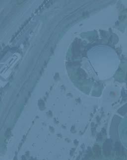
5 2 Up to approximately 60 on-street spaces 1 Approximately 80 on-street spaces Gable Ct Vista Marin Dr Avenue of the Flags Scettrini Dr 3 McInnis Pkwy Approximately 30 off-street spaces could be constructed Civic Center Dr spaces provided by SMART Redwood Hwy Merrydale Rd Las Gallinas Ave Las Flores Ave Merrydale Oc Merrydale Rd Northgate Dr Los Ranchitos Rd LEGEND = 1/4 Mile Radius n Not to Scale SF San Rafael Civic Center SAP\Deliverables\Station Area Plan Report\Graphics_Final_Report POTENTIAL ADDITIONAL PARKING SUPPLY FIGURE 14


6 32 SPACES n nded ering for R O Y S T O N H A N A M O T O A L L E Y & A B E Y 225 Miller Avenue Mill Valley, CA Geary Street, #602 San Francisco, CA SF San Rafael Civic Center SAP\Deliverables\Station Area Plan Report\Graphics_Final_Report POTENTIAL NEW PARKING SITE SMART COMMUTER RAIL PROJECT FIGURE 15
7 Potential strategies could include: Transit incentive programs, whereby employers subsidize the cost of transit passes for employees who elect not to drive Provision of parking spaces for carshare programs Unbundled parking, whereby the cost of a parking space is removed (i.e., unbundled) from the cost of housing, ensuring that residents who do not own cars or who choose to own fewer cars do not have to pay for parking spaces Shared parking, whereby complimentary land uses that do not experience peak parking demands simultaneously can share parking facilities and make more efficient use of parking supply Bike Parking for Station and in New Development SMART will provide 6 bike racks (which could accommodate at least 2 bicycles each, and possibly 8 or more) and 8 bike lockers as part of the station design. The City of San Rafael requires new development to include bike parking of at least five percent of the number of auto parking spaces provided, per Section of the City s Zoning Code. The City and SMART should ensure adequate bike parking is provided at the station and throughout the area. The demand for bike parking provided at the station should be monitored over time and additional space provided if needed. 4.4 RECOMMENDATIONS The parking recommendations in this plan aim to ensure adequate parking for new housing, businesses, and commuters while encouraging transit use. 1. Explore residential parking permits and time limits. Residential parking permits coupled with 2 or 4-hour time limits can protect neighborhoods from long-term commuter parking spillover. 2. Provide more commuter parking opportunities throughout the area. Three additional parking opportunities have been identified for SMART commuter parking. This will be public parking and therefore they will be open to non-smart users as well. They are: a. McInnis Parkway, approximately 80 on-street parking spaces b. Merrydale North, approximately 65 on-street spaces (depending on how the roadway is configured without compromising the planned promenade extension) c. Vacant parcel northeast of station, approximately 32 spaces (can include some ADA parking for SMART and possibly more bike parking for station) d. If more parking is needed, the City and County should pursue the use of public lots for SMART parking e. Consider using new technology as it develops to communicate real-time availability of parking to station users. 51
8 3. Coordinate parking controls. A successful parking strategy will require extensive on-going coordination and planning for increased parking demand between the County of Marin, SMART and the City of San Rafael. The City should survey the SMART related parking situation annually to identify problems and seek solutions. 4. Reduce parking requirements. If coupled with other strategies that can demonstrably show a reduced demand for parking, such as transit incentive programs, carsharing, shuttles, unbundling parking, and shared parking, new development may need less parking than the current ordinance requires. Developments seeking to provide less parking may be subject to periodic review for efficiency. Reduced requirements can also be linked to neighborhood serving uses such as drycleaning and Laundromats, drug stores, and food stores. 5. Provide bike parking. Provide adequate bike parking at the station and in new development. 52
appendix 4: Parking Management Study, Phase II
 appendix 4: Parking Management Study, Phase II A4-1 A4-2 Eastlake Parking Management Study Final Phase 2 Report Future Parking Demand & Supply January 6, 2017 Submitted by Denver Corp Center III 7900 E.
IV. ENVIRONMENTAL IMPACT ANALYSIS K.2. PARKING
 IV. ENVIRONMENTAL IMPACT ANALYSIS K.2. PARKING ENVIRONMENTAL SETTING The following analysis summarizes the findings and conclusions of the Traffic Analysis (Traffic Study), prepared by The Mobility Group,
Address Land Use Approximate GSF
 M E M O R A N D U M To: Kara Brewton, From: Nelson\Nygaard Date: March 26, 2014 Subject: Brookline Place Shared Parking Analysis- Final Memo This memorandum presents a comparative analysis of expected
Denver Car Share Program 2017 Program Summary
 Denver Car Share Program 2017 Program Summary Prepared for: Prepared by: Project Manager: Malinda Reese, PE Apex Design Reference No. P170271, Task Order #3 January 2018 Table of Contents 1. Introduction...
CORE AREA SPECIFIC PLAN
 only four (A, B, D, and F) extend past Eighth Street to the north, and only Richards Boulevard leaves the Core Area to the south. This street pattern, compounded by the fact that Richards Boulevard is
Transportation Sustainability Program
 Transportation Sustainability Program Photo: Sergio Ruiz A Comprehensive Approach to Growing Sustainably Public Investment and Strategies for Existing and Future Population Underway Transit capital and
M E M O R A N D U M INTRODUCTION. POTENTIAL TDM STRATEGIES Marketing & Management. Residents & Employees. Exhibit 6
 Exhibit 6 M E M O R A N D U M To: From: Joe Ernst and Bryan Graves Nelson\Nygaard Date: February 6, 2015 Subject: Preliminary TDM Strategies INTRODUCTION The memorandum provides an overview of potential
ANDERSON PROPERTY SITE ANALYSIS
 ANDERSON PROPERTY SITE ANALYSIS Introduction The Montgomery County Department of Transportation (MCDOT) initiated a feasibility study in the fall of 2012 to evaluate the need for transit service expansion
Downtown Parking/Wayfinding Study. Review of Recommendations to City Council: January 16, 2018
 Downtown Parking/Wayfinding Study Review of Recommendations to City Council: January 16, 2018 Tonight s Focus Objectives & Timeline Recap Study Findings Present Staff Recommendations 2018 Action items
Parking Management Element
 Parking Management Element The State Transportation Planning Rule, adopted in 1991, requires that the Metropolitan Planning Organization (MPO) area implement, through its member jurisdictions, a parking
2.0 Development Driveways. Movin Out June 2017
 Movin Out June 2017 1.0 Introduction The proposed Movin Out development is a mixed use development in the northeast quadrant of the intersection of West Broadway and Fayette Avenue in the City of Madison.
Key Findings and Recommendations Introduction and Overview Task 1 Existing Conditions Analysis Task 2 Parking Demand Analysis...
 Table of Contents Introduction and Overview... 1 Key Findings and Recommendations... 1 Task 1 Existing Conditions Analysis... 1 Task 2 Parking Demand Analysis... 1 Task 3 Facilities Cost Analysis... 2
Mercer Island Town Center Parking Study Joint Commission Presentation March 16, 2016
 Mercer Island Town Center Parking Study Joint Commission Presentation March 16, 2016 Mercer Island Town Center Parking Study Study Area Town Center Bordered by Sunset Way, Island Crest Way, SE 32 nd Street,
Transportation Sustainability Program
 Transportation Sustainability Program Photo: Sergio Ruiz San Francisco 2016 Roads and public transit nearing capacity Increase in cycling and walking despite less than ideal conditions 2 San Francisco
DRAFT Commission, based upon the requirements of comparable uses listed.
 Chapter 345 OFF-STREET PARKING AND LOADING 345.01 Purpose 345.02 General Provisions 345.03 Off-Street Parking Standards 345.04 Off-Street Loading Standards Commission, based upon the requirements of comparable
APPENDIX VMT Evaluation
 APPENDIX 2.7-2 VMT Evaluation MEMORANDUM To: From: Mr. Jonathan Frankel New Urban West, Incorporated Chris Mendiara LLG, Engineers Date: May 19, 2017 LLG Ref: 3-16-2614 Subject: Villages VMT Evaluation
TRANSPORTATION REVIEW
 TRANSPORTATION REVIEW - PROPOSED MIX OF LAND USES IS CONSISTENT WITH THE CITY S UNDER THE GRANVILLE BRIDGE POLICIES THAT AIM TO MEET NEIGHBOURING RESIDENTS SHOPPING NEEDS AND REDUCE RELIANCE ON AUTOMOBILE
Mercer Island Center for the Arts Parking Management Plan
 Parking Stalls Mercer Island Center for the Arts Parking Management Plan June 15, 2016 This Parking Management Plan (P) covers all tenants at the Mercer Island Center for the Arts (MICA) campus, including
THE CORNERSTONE APARTMENTS TRAFFIC IMPACT STUDY R&M PROJECT NO
 THE CORNERSTONE APARTMENTS SITUATED AT N/E/C OF STAUDERMAN AVENUE AND FOREST AVENUE VILLAGE OF LYNBROOK NASSAU COUNTY, NEW YORK TRAFFIC IMPACT STUDY R&M PROJECT NO. 2018-089 September 2018 50 Elm Street,
Off-Street Parking Information
 Off-Street Parking Information City of Richardson, Texas Excerpt from Chapter 21, Subdivision and Development, of the City of Richardson, Texas Code of Ordinances. Note: Due to the adoption of the Main
Executive Summary. Treasure Valley High Capacity Transit Study Priority Corridor Phase 1 Alternatives Analysis October 13, 2009.
 Treasure Valley High Capacity Transit Study Priority Corridor Phase 1 Alternatives Analysis October 13, 2009 Background As the Treasure Valley continues to grow, high-quality transportation connections
EXECUTIVE SUMMARY. Introduction
 EXECUTIVE SUMMARY Introduction The purpose of this study is to ensure that the Village, in cooperation and coordination with the Downtown Management Corporation (DMC), is using best practices as they plan
Appendix C. Parking Strategies
 Appendix C. Parking Strategies Bremerton Parking Study Introduction & Project Scope Community concerns regarding parking impacts in Downtown Bremerton and the surrounding residential areas have existed
3.6 Parking and Loading Conditions
 3.6 Parking and Loading Conditions This section presents vehicle parking and loading supply and demand conditions for the Geary corridor. The study area for this parking and loading analysis includes onstreet
Getting Parking Right. Presented by Lisa Jacobson Rail~Volution Seattle October 2013
 Getting Parking Right Presented by Lisa Jacobson Rail~Volution Seattle October 2013 Parking Wastes Money $20,000 $20,000 $20,000 $20,000 $20,000 $20,000 $20,000 $20,000 $20,000 $20,000 $20,000 $20,000
PARKING MANAGEMENT PLAN PROPOSED MIXED-USE DEVELOPMENT AT URL STAMFORD Parcel 38 Greyrock Place and Tresser Boulevard Stamford, CT April 2, 2014
 PARKING MANAGEMENT PLAN PROPOSED MIXED-USE DEVELOPMENT AT URL STAMFORD Parcel 38 Greyrock Place and Tresser Boulevard Stamford, CT April 2, 2014 This plan has been prepared in support of a proposed mixed-use
METRO Orange Line BRT American Boulevard Station Options
 METRO Orange Line BRT American Boulevard Station Options Bloomington City Council Work Session November 18, 2013 Christina Morrison BRT/Small Starts Project Office Coordinating Planning and Design AMERICAN
Transportation Demand Management Element
 Transportation Demand Management Element Over the years, our reliance on the private automobile as our primary mode of transportation has grown substantially. Our dependence on the automobile is evidenced
CITY OF OMAHA OMAHA, NEBRASKA
 DOWNTOWN PARKING NEEDS ASSESSMENT UPDATE CITY OF OMAHA OMAHA, NEBRASKA Prepared for: City of Omaha Parking Division October 15, 2014 FINAL REPORT TABLE OF CONTENTS EXECUTIVE SUMMARY... 1 Study Purpose...
Executive Summary EXECUTIVE SUMMARY Parking Issues Trenton Downtown Parking Policy and Sidewalk Design Standards E.S. Page 1 Final Report 2008
 EXECUTIVE SUMMARY A walkable environment that accommodates market demand while minimizing the negative impacts of growth is an important element in promoting the City s downtown revitalization. There are
6/6/2018. June 7, Item #1 CITIZENS PARTICIPATION
 June 7, 2018 Item #1 CITIZENS PARTICIPATION 1 Item #2 APPROVAL OF MINUTES Item #3 TRAC GOALS, FRAMEWORK & AGENDA REVIEW 2 COMMITTEE GOALS Learn about Southern Nevada s mobility challenges, new developments
Metra Milwaukee District West Line Transit-Friendly Development Plan
 Metra Milwaukee District West Line Transit-Friendly Development Plan Community Input Workshop April 6, 2011 Overview of Presentation Workshop Goals Study Context Existing Conditions Market Overview Employment
Purpose: General Provisions:
 10-19-1 Purpose: The purpose of off-street parking requirements is to promote traffic/pedestrian safety and efficiency and to minimize hard surfaced areas to reduce storm water run-off and visual impacts
OFF-STREET PARKING REFORM IN MINNEAPOLIS AND ST. PAUL
 OFF-STREET PARKING REFORM IN MINNEAPOLIS AND ST. PAUL MINNESOTA APA October 1, 2014 Minneapolis Zoning Codes 1924 City s first zoning code 1963 City s second zoning code, which included the city s first
Getting Parking Right in Emerging Mixed Use Environments
 Getting Parking Right in Emerging Mixed Use Environments Shana R. Johnson, AICP Senior Transportation Planner Foursquare ITP Makeover Montgomery 2 May 9, 2014 1 Parking today White Flint Mall Photo Source:
Trip Generation & Parking Occupancy Data Collection: Grocery Stores Student Chapter of Institute of Transportation Engineers at UCLA Spring 2014
 Trip Generation & Parking Occupancy Data Collection: Grocery Stores Student Chapter of Institute of Transportation Engineers at UCLA Spring 2014 Page 1 Introduction The UCLA Institute of Transportation
La Jolla Community Parking Management Plan A PLAN TO ADDRESS PARKING ISSUES AND TO UNIFY OUR COMMUNITY March 1, 2008
 DRAFT FOR DISCUSSION PURPOSES ONLY La Jolla Community Parking Management Plan A PLAN TO ADDRESS PARKING ISSUES AND TO UNIFY OUR COMMUNITY March 1, 2008 [This is not to be read as a completed or finished
Attachment D Environmental Justice and Outreach
 Attachment D Environmental Justice and Outreach ATTACHMENT D Environmental Justice and Outreach Indicate whether the project will have disproportionately high and adverse impacts on minority or low income
Otay Ranch Station 2020 MOBILITY SERVICES MAP REGIONAL MOBILITY HUB IMPLEMENTATION STRATEGY
 MAGDALENA REGIONAL MOBILITY HUB IMPLEMENTATION STRATEGY Otay Ranch Station Mobility hubs are transportation centers located in smart growth areas served by high frequency transit service. They provide
Planning Commission Travis Parker, Planning Director DATE: March 7, 2018 SUBJECT: Lakewood Zoning Amendments - Parking
 MEMORANDUM TO: FROM: Planning Commission Travis Parker, Planning Director DATE: March 7, 2018 SUBJECT: Lakewood Zoning Amendments - Parking In August 2017, the Lakewood Development Dialogue process began
Develop ground transportation improvements to make the Airport a multi-modal regional
 Project Overview TRANSPORTATION IMPROVEMENTS WHAT ARE THE PROJECT GOALS? Transportation transportation hub. Develop ground transportation improvements to make the Airport a multi-modal regional Land Use
ARTICLE 501 OFF-STREET PARKING AND LOADING
 ARTICLE 501 OFF-STREET PARKING AND LOADING Sec. 501.01 Applicability. (a) Zoning districts. These requirements for adequate off-street parking, and loading shall be provided in all zoning districts. Such
Saint Paul s Off-Street Parking Revisions. Hilary Holmes City Planner
 Saint Paul s Off-Street Parking Revisions Hilary Holmes City Planner Today: Citywide off-street parking revisions 2009 Bar & restaurant revisions 2012 Establishing maximums Other off-street reductions
Transportation & Traffic Engineering
 Transportation & Traffic Engineering 1) Project Description This report presents a summary of findings for a Traffic Impact Analysis (TIA) performed by A+ Engineering, Inc. for the Hill Country Family
The hidden prices of parking David King Graduate School of Architecture, Planning and Preservation Columbia University
 The hidden prices of parking David King Graduate School of Architecture, Planning and Preservation Columbia University Planning of the automobile city focuses on saving time. Planning for the accessible
6.16 OFF-STREET PARKING AND LOADING REQUIREMENTS
 6.16 OFF-STREET PARKING AND LOADING REQUIREMENTS 6.16.1 Off-Street Parking Off-street parking and loading spaces shall be required for all land uses as set forth in this section. A. Minimum Parking Space
Downtown Lee s Summit Parking Study
 Downtown Lee s Summit Parking Study As part of the Downtown Lee s Summit Master Plan, a downtown parking and traffic study was completed by TranSystems Corporation in November 2003. The parking analysis
ROCHESTER, MINNESOTA
 ROCHESTER, MINNESOTA Rochester Public Works TRANSIT AND PARKING DIVISION Transit and Parking Manager Tony Knauer tknauer@rochestermn.gov SERVICE ATTITUDE CONSISTENCY - TEAMWORK ROCHESTER TRANSIT & PARKING
2.303 OFF-STREET PARKING AND LOADING
 CITY OF KEIZER DEVELOPMENT BULLETIN 2.303 OFF-STREET PARKING AND LOADING 2.303.01 Purpose The purpose of this Section is to provide standards to ensure adequate areas for the parking, maneuvering, loading
ALTERNATIVES FOR REDUCING OR ELIMINATING COMPACT CAR PARKING. City Council Transportation and Environment Committee February 25, 2008
 ALTERNATIVES FOR REDUCING OR ELIMINATING COMPACT CAR PARKING City Council Transportation and Environment Committee February 25, 2008 2 PURPOSE Brief the committee on compact parking allowances and parking
ON-STREET AND OFF-STREET PARKING SURVEY: METHODOLOGY AND RESULTS
 ON-STREET AND OFF-STREET PARKING SURVEY: METHODOLOGY AND RESULTS TOWN OF WINDSOR, CT REPORT JUNE 2016 CONTENTS Parking Survey Design... 3 Parking Supply Inventory... 3 Parking Demand Survey... 3 Surveyed
LEED v4 Building Design and Construction Quiz #3 LT
 LEED v4 Building Design and Construction Quiz #3 LT 1. How are walking and bicycling distance measured? A. Straight-line radius from a main building entrance B. Straight-line radius from any building entrance
Long Bridge Park. Parking Analysis and Transportation Management Plan. Long Range Planning Committee of the Planning Commission Meeting
 Long Bridge Park Parking Analysis and Transportation Management Plan Long Range Planning Committee of the Planning Commission Meeting Thursday, February 7, 2013 Purpose Achieve consensus on parking and
MOTOR VEHICLE PARKING AREA STANDARDS
 1015 PARKING AND LOADING 1015.01 GENERAL STANDARDS A. Inside the Portland Metropolitan Urban Growth Boundary (UGB), parking, loading, and maneuvering areas shall be hard-surfaced, unless a permeable surface
D. Motor vehicle parking, bicycle parking, and loading areas shall be separated from one another.
 1015 PARKING AND LOADING 1015.01 GENERAL STANDARDS A. Inside the Portland Metropolitan Urban Growth Boundary (UGB), parking, loading, and maneuvering areas shall be hard-surfaced, unless a permeable surface
Santa Rosa Downtown Progressive Parking Strategy & Railroad Square Parking Plan. Presented by: Lauren Mattern
 Santa Rosa Downtown Progressive Parking Strategy & Railroad Square Parking Plan Presented by: Lauren Mattern October 2016 Today s Agenda Project Overview Current System Highlights Community Outreach Feedback
CHAPTER 9: VEHICULAR ACCESS CONTROL Introduction and Goals Administration Standards
 9.00 Introduction and Goals 9.01 Administration 9.02 Standards 9.1 9.00 INTRODUCTION AND GOALS City streets serve two purposes that are often in conflict moving traffic and accessing property. The higher
Re: Amend Sections and File No ZA Marcus Lotson, Development Services Planner
 Page 1 To: From: The Planning Commission MPC Staff Date: April 5, 2016 Subject: Re: Amend Sections 8-3082 and 8-3090 Marcus Lotson, Development Services Planner Issue: Proposed amendments to the zoning
Bi-County Transitway/ Bethesda Station Access Demand Analysis
 Bi-County Transitway/ Bethesda Station Access Demand Analysis Prepared for: Washington Metropolitan Area Transit Authority Office of Planning and Project Development May 2005 Prepared by: in conjunction
TR15: Public Outreach
 TR15: Public Outreach Brief Summary: The Public Outreach control measure includes activities to encourage Bay Area residents to make choices that benefit air quality. This measure includes various public
PARKING OCCUPANCY IN WINDSOR CENTER
 PARKING OCCUPANCY IN WINDSOR CENTER TOWN OF WINDSOR, CONNECTICUT REPORT JUNE 2017 CONTENTS Background... 3 Other Relevant Data... 3 Parking Survey Design... 6 Parking Supply Inventory... 6 Parking Demand
CHECKLIST CONDITIONAL USE PERMIT APPLICATION Authority: New Castle Municipal Code & et seq.
 Administration Department (970) 984-2311 Fax: (970) 984-2716 www.newcastlecolorado.org Town of New Castle PO Box 90 450 W. Main Street New Castle, Co 81647 CHECKLIST CONDITIONAL USE PERMIT APPLICATION
APPENDIX C. ISLA VISTA ON-STREET PARKING AVAILBILITY
 APPENDIX C. ISLA VISTA ON-STREET PARKING AVAILBILITY PAGE INTENTIONALLY LEFT BLANK APPENDIX C. ISLA VISTA ON-STREET PARKING AVAILABILITY EXECUTIVE SUMMARY The Appendix is a compilation of updated data
This letter provides SPUR s comments on the Draft Supplemental Environmental Impact Statement/ Subsequent Environmental Impact Report.
 Tom Fitzwater, Environmental Planning Manager VTA Environmental Programs & Resources Management 3331 North First Street, Building B-2 San Jose, CA 95134 March 6, 2017 Submitted Electronically Re: VTA s
71, 75 MONTREAL STREET PARKING STUDY
 71, 75 MONTREAL STREET PARKING STUDY Prepared for: Prepared by: Urban Core Ventures Boulevard Transportation, a division of Watt Consulting Group Our File: 1975 Date: June 20 2016 CONTENTS 1.0 INTRODUCTION...
On-Street Parking Program
 On-Street Parking Program Williamsville Area - Public Information Session January 12, 2017 Project Timeline and Consultation Neighbourhood information session June 2016 Online survey August/September 2016
Mansion Neighborhood Parking Study
 Capital District Transportation Committee Mansion Neighborhood Parking Study Albany, New York Prepared For: Albany Local Development Corporation, and The Capital District Transportation Committee By: Wilbur
EUGENE-SPRINGFIELD, OREGON EAST WEST PILOT BRT LANE TRANSIT DISTRICT
 EUGENE-SPRINGFIELD, OREGON EAST WEST PILOT BRT LANE TRANSIT DISTRICT (BRIEF) Table of Contents EUGENE-SPRINGFIELD, OREGON (USA)... 1 COUNTY CONTEXT AND SYSTEM DESCRIPTION... 1 SYSTEM OVERVIEW... 1 PLANNING
Study Purpose 2 Densely populated neighborhoods and increased rates of car ownership over the years have led to serious parking issues in the Canal, S
 July 12, 2017 Study Purpose 2 Densely populated neighborhoods and increased rates of car ownership over the years have led to serious parking issues in the Canal, Spinnaker, and Baypoint neighborhoods.
Orange Line Transit Neighborhood Planning Effort GOALS. mobility
 Transit Neighborhood ning Effort GOALS mobility walkability mix of uses public space jobs & housing ort h We ntw Gl t ds Transit Neighborhood ning Effort or f nd ks oa en CORRIDOR VISION a Bl Br vd Tampa
APPENDIX TR-1 PARKING AND QUEUING ASSESSMENT
 APPENDIX TR-1 PARKING AND QUEUING ASSESSMENT Overland Overland Traffic Consultants, Traffic Consultants, Inc. Inc. Overland Traffic Consultants 952 Manhattan Beach Boulevard, Suite #100 Manhattan Beach,
Parking Management Strategies
 Parking Management Strategies Policy Program Potential Effectiveness (percent reduction in demand) Comments Parking Pricing Unbundling and Cash-Out Options Reduced Parking Requirements Transit/TOD Supportive
10 May 14, 2014 Public Hearing
 10 May 14, 2014 Public Hearing APPLICANT: PROPERTY OWNER: AEGEAN ASSOCIATES CUP-Truck and Trailer Rentals STAFF PLANNER: Kristine Gay REQUEST: Conditional Use Permit for Truck and Trailer Rentals ADDRESS
OFF-STREET PARKING AND LOADING
 PART 7 OFF-STREET PARKING AND LOADING 701 This section is intended for use at a future date. 702 This section is intended for use at a future date. 703 Non-Conformity in Off-Street Parking or Loading Spaces
Letter EL652 City of Mercer Island. Page 1. No comments n/a
 Letter EL652 City of Mercer Island Page 1 No comments n/a Page 2 Response to comment EL652 1 Section 4.5.3 of the Final EIS presents the range of potential impacts of the project. This project also lists
Equitable transit-oriented development: Tools + Tactics
 Equitable transit-oriented development: Tools + Tactics Yonah Freemark February 18, 2016 Metropolitan Planning Council Chicagoland s growth over time 1950 Population density Fewer than 2,000 ppl/sq. mi.
August 2, 2010 Public Meeting
 Public Meeting LYMMO Expansion Alternatives Analysis Study Purpose of study is to provide a fresh look at potential LYMMO expansion, following Federal Transit Administration (FTA) Alternatives Analysis
Mission Bay Parking Management Strategy OCTOBER 28, 2011
 Mission Bay Parking Management Strategy PAGE 2 Overview Introduction The San Francisco Municipal Transportation Agency (SFMTA), in partnership with the Port of San Francisco (Port), has long planned to
San Rafael Civic Center SMART Station Area Plan. Background Report
 San Rafael Civic Center SMART Station Area Plan This project is funded in part through the Metropolitan Transportation Commission s Station Area Planning Program. The preparation of this report has been
On June 11, 2012, the Park Board approved the installation of three electric vehicle charging stations along Beach Avenue.
 January 8, 2017 TO: Park Board Chair and Commissioners FROM: General Manager Vancouver Board of Parks and Recreation SUBJECT: Electric Vehicle Charging Stations New Park Board Locations RECOMMENDATION
IMPROVEMENT CONCEPTS
 IMPROVEMENT CONCEPTS for the South Novato Transit Hub Study Prepared by: January 11, 2010 DKS Associates With Wilbur Smith Associates IMPROVEMENT CONCEPTS Chapter 1: Introduction 1. INTRODUCTION The strategic
NEW YORK CITY CARSHARE PILOT
 NEW YORK CITY CARSHARE PILOT Community Board Briefing June 2017 1 Concept and Context 1 nyc.gov/dot 2 NEW YORK CITY IS GROWING Largest ever population and employment base 2010-2015: 370,000 new residents
Traffic Impact Analysis West Street Garden Plots Improvements and DuPage River Park Garden Plots Development Naperville, Illinois
 Traffic Impact Analysis West Street Garden Plots Improvements and DuPage River Park Garden Plots Development Naperville, Illinois Submitted by April 9, 2009 Introduction Kenig, Lindgren, O Hara, Aboona,
2018 Long Range Development Plan Update Community Advisory Group- February 21, 2018
 Transportation @ UC San Diego 2018 Long Range Development Plan Update Community Advisory Group- February 21, 2018 Agenda UC San Diego Transportation Services Organizational Overview Current State Parking,
David Martin, Director of Planning and Community Development. Establishment of LAX FlyAway Stop in Santa Monica
 Information Item Date: January 31, 2014 To: From: Subject: Mayor and City Council David Martin, Director of Planning and Community Development Establishment of LAX FlyAway Stop in Santa Monica Introduction
BROWARD BOULEVARD CORRIDOR TRANSIT STUDY
 BROWARD BOULEVARD CORRIDOR TRANSIT STUDY FM # 42802411201 EXECUTIVE SUMMARY July 2012 GOBROWARD Broward Boulevard Corridor Transit Study FM # 42802411201 Executive Summary Prepared For: Ms. Khalilah Ffrench,
Construction Realty Co.
 MEMORANDUM TO: FROM : Jeff Pickus Construction Realty Co. Luay R. Aboona, PE Principal 9575 West Higgins Road, Suite 400 Rosemont, Illinois 60018 p: 847-518-9990 f: 847-518-9987 DATE: May 22, 2014 SUBJECT:
IRONTON MULTIMODAL PARKING STUDY
 INTRODUCTION Due to local economic growth and multimodal transportation needs in Ironton, the Lawrence County Port Authority (LCPA) and the City of Ironton have partnered with KYOVA Interstate Planning
1
 1 2 3 4 5 6 7 8 9 10 11 12 Breakdown of License Changes Definitions First Draft ROW License Changes in Revised Draft Explanation of Change Dockless sharing Shared active transportation vehicle NACTO recommendation
1.963 Report: A Sustainable Transportation Plan for MIT Campus May 2007
 1.963 Report: A Sustainable Transportation Plan for MIT Campus May 2007 Authors: David Block-Schachter Michael Kay Francesca Napolitan Tegin Teich Supervisors: John Attanucci, Lawrence Brutti, Fred Salvucci
Final Report 1.0 INTRODUCTION 2.0 METHODOLOGY
 Final Report Date: December 7, 2015 To: Mitch Moroziuk cc: From: James Donnelly 1.0 INTRODUCTION The City of Penticton has requested that Urban Systems Ltd. investigate the potential parking impacts of
JOINT FACILITIES ADVISORY COMMISSION. ART and APS Bus Parking Informational Session July 27, :30 pm
 ART and APS Bus Parking Informational Session July 27, 2017 7 8:30 pm 2 Agenda Introductions & overview APS Bus Parking APS Bus Facts APS Bus Operations ART Bus Parking Story of ART and its role in County
ARTICLE 9 OFF-STREET PARKING AND LOADING
 ARTICLE 9 OFF-STREET PARKING AND LOADING Section 9.1 Intent and Purpose. The purpose of this section is to ensure the provision of off-street parking facilities that are sufficient in number, adequately
Food Truck Consulting Study of Proposed Food Truck Regulations
 Food Truck Consulting Study of Proposed Food Truck Regulations Introduction The City of San Diego is considering revisions to its mobile vending ordinance. The revised ordinance would, in part, 1) prevent
OFF-STREET PARKING. A. Parking facilities for each use shall be provided in accord with the minimum requirements set forth in Table 9-1.
 09 ARTICLE NINE OFF-STREET PARKING 9-1 Purpose The off-street parking regulations require that developments provide parking in proportion to the need created by each use. The regulations further establish
FROM: CITY MANAGER DEPARTMENT: PLANNING & COMMUNITY ENVIRONMENT
 TO: HONORABLE CITY COUNCIL FROM: CITY MANAGER DEPARTMENT: PLANNING & COMMUNITY ENVIRONMENT DATE: AUGUST 9, 2004 CMR: 380:04 SUBJECT: ZONING ORDINANCE UPDATE ADOPTION OF A NEW AUTOMOBILE DEALERSHIP (AD)
Trip Generation Study: Provo Assisted Living Facility Land Use Code: 254
 Trip Generation Study: Provo Assisted Living Facility Land Use Code: 254 Introduction The Brigham Young University Institute of Transportation Engineers (BYU ITE) student chapter completed a trip generation
* * * * * * * * * * * *
 ORDINANCE NO. 2015-04 AN ORDINANCE OF THE PORT ARANSAS CITY COUNCIL AMENDING CHAPTER 25 ZONING, ARTICLE I. IN GENERAL, SECTION 25-1 DEFINITIONS BY ADDING DEFINITIONS FOR BEDROOM, SLEEPING ROOMS, IMPROVED
ARTICLE 8 OFF-STREET PARKING AND PRIVATE DRIVEWAY STANDARDS
 ARTICLE 8 OFF-STREET PARKING AND PRIVATE DRIVEWAY STANDARDS TABLE OF CONTENTS SECTION PAGE 8.1 GENERAL STANDARDS...8-2 8.2 PRIVATE DRIVEWAY PROVISIONS...8-4 8.3 OFF-STREET PARKING STANDARDS...8-5 8.4 OFF-STREET
Paid Parking at Park & Ride Lots: Framing the Issues. Capital Programs Committee May 2014
 Paid Parking at Park & Ride Lots: Framing the Issues Capital Programs Committee May 2014 Outline Current Status Industry Review DART Case Study Issues Alternatives Mechanics 2 Current Status: All Lots