WESTSIDE SUBWAY EXTENSION PROJECT. Construction Traffic Analysis Report
|
|
|
- Marjorie Townsend
- 6 years ago
- Views:
Transcription

1 PROJECT Construction Traffic Analysis Report August 2011
2 Table of Contents Table of Contents INTRODUCTION Objectives of the Report Project Overview Approach CONSTRUCTION ACTIVITIES AND STAGING Construction Activities Utility Relocation and Property Acquisitions Construction of Stations, Crossovers, and Emergency Exit Shafts Tunnel Construction Construction Staging and Sequencing Construction Laydown Areas Wilshire/Western Station Construction Staging and Laydown Site Wilshire/Crenshaw Construction Staging and Laydown Site Wilshire/La Brea Station Wilshire/Fairfax Station Wilshire/La Cienega Station Wilshire/Rodeo Station Century City Station Westwood/UCLA Station Westwood/VA Hospital Station TRAFFIC HANDLING Traffic Handling Standards and Guidelines State and National Local Agency Requirements and Guidelines Traffic Control Zone Traffic Control Zone Limits Traffic Lane Requirements Temporary Street Closures and Detour Routes Closed Streets Traffic Circulation Routes Traffic Impacts Due to Street Closures and Traffic Diversions Temporary Traffic Signal Plans Temporary Striping and Signing Parking Restriction and Parking Meters Parking Conditions Temporary Parking Locations Loading Zones Bus Stop Locations Pedestrian, Bicycle, and Vehicular Access Pedestrian Detours Bicycle Access Access and Impacts to Commercial and Business Driveways TRUCK HAUL ROUTES Wilshire/Western (TBM Removal Location) Wilshire/Crenshaw (Construction Staging Site) Wilshire/La Brea (Station, Crossovers, TBM Launch Location) Wilshire/Fairfax (Station) August 2011 Page i
3 Table of Contents Wilshire/La Cienega (Station, Crossovers, TBM Removal Location) Wilshire/Rodeo (Station, Crossovers) Century City Century City Santa Monica Boulevard (Station, Crossovers, TBM Launch Location), Scenarios A and B Century City Constellation Boulevard (Station, Crossovers, TBM Launch Location) Scenarios A and B Westwood/UCLA (Station) Westwood/VA Hospital (Station, Crossovers, TBM Launch Location) South Station Location, Scenarios A and B North Station Location GSA Double Crossover Location SUMMARY OF CONSTRUCTION TRAFFIC MITIGATION Impacts on Traffic and Circulation Traffic Control Plans Designated Haul Routes Emergency Vehicle Access Transportation Management Plan Coordination with Planned Roadway Improvements Impacts on Public Transit Temporary Bus Stops and Route Diversions Impacts on Parking Parking Replacement Construction Worker Parking Impacts on Pedestrians and Bicycles Pedestrian Routes and Access Bicycles Paths and Access NEXT STEPS Preliminary Engineering and Design Phase Activities Construction Phase Activities Third-Party Coordination Page ii August 2011
4 Table of Contents List of Figures Figure 1-1: Locally Preferred Alternative (LPA) Figure 2-1: Proposed Construction Sequencing Concept Wilshire/La Brea Station Figure 2-2: Anticipated Trucking Sequencing and Durations List of Tables Table 2-1: Traffic Control Activities during Construction Table 3-1: Traffic Control Zones Table 3-2: Traffic Lane Requirements during Construction Table 3-3: Key Intersections Identified for Evaluation Due to Construction Impacts Table 4-1: Common Roadways in Proposed Haul Routes for Construction Locations Table 4-2: Haul Route Features Table 4-3: Estimated Daily Haul Truck Trips Appendix A Appendix B Construction Laydown Areas Truck Haul Route Concepts List of Appendices August 2011 Page iii
5 Final Construction Traffic Analysis Report Acronyms and Abbreviations Acronyms and Abbreviations CA MUTCD EIS/EIR EPB GSA California Manual of Uniform Traffic Control Devices environmental impact statement/environmental impact report earth-pressure balance tunnel boring machine General Services Administration I-10 Interstate 10 I-405 Interstate 405 LABOE LADOT LAX LPA Metro Project TBM TMP UCLA VA WATCH Manual City of Los Angeles Bureau of Engineering City of Los Angeles Department of Transportation Los Angeles International Airport Locally Preferred Alternative Los Angeles County Metropolitan Transportation Authority Westside Subway Extension Project tunnel boring machine Transportation Management Plan University of California at Los Angeles Veterans Affairs Work Area Traffic Control Handbook Page iv August 2011
6 1.0 Introduction 1.0 INTRODUCTION The Westside Subway Extension Project (Project) will involve major construction activities that will occur over a period of approximately eight to nine years. It is expected that construction of the Project will employ conventional construction techniques and equipment typically used in the Southern California region. All construction-related work activities will conform to accepted industry specifications and standards. The major project elements include tunnels, underground stations, station-related facilities, maintenance and operations yards and buildings, trackwork, ventilation equipment, and specialty systems such as traction power, communications, and signaling equipment. Construction activities, even though temporary and intermittent, could impede the normal flow of traffic, transit, pedestrians, and bicycles due to closures of certain lanes and roadway segments. In addition, truck traffic will increase during certain times of the day on major City arterials due to the hauling of excavated spoil materials (muck) from construction laydown sites to approved off-site disposal areas. In order to minimize potential traffic disruptions, feasible mitigation measures to address temporary traffic impacts will be identified, traffic management plans will be developed, and traffic control measures will be implemented with the coordination and involvement of the Los Angeles County Metropolitan Transportation Authority (Metro), local agencies, and major attractors/employers along the project alignment. 1.1 Objectives of the Report The key objectives of this report are to identify and present transportation-related impacts associated with construction of the Westside Subway Extension Project and summarize the traffic handling approach during the construction period. Transportation elements that will be affected by the Project s construction activities include traffic circulation, transit, parking, pedestrians, and bicycles. Traffic handling and control procedures are required to address potential impacts associated with construction laydown areas, stations, crossovers, mining entry and exit locations, tunnel boring machine (TBM) operations and support activities, truck haul routes, transportation of oversized construction materials, station portals, emergency exit shafts, grout injection, and drop holes. In addition, feasible short-term mitigation measures to address construction-related temporary impacts are discussed, and the next steps to be taken during the design and construction phases of the Project are summarized. 1.2 Project Overview Several alignment alternatives were considered and evaluated in the Draft Environmental Impact Statement/Environmental Impact Report (Draft EIS/EIR). The environmental document was circulated by Metro for public review and comment. In October 2010, the Los Angeles Metro Board of Directors selected Alternative 2, which is the Westwood/VA) Hospital Extension, as the Locally Preferred Alternative (LPA) with several recommendations to the proposed station and alignment options and associated rail support facilities. The LPA, which is the project that will be carried forward for final environmental clearance, consists of an approximate 9-mile extension of the existing Metro Purple Line subway with seven stations, located at approximately 1-mile intervals, extending from its current terminus at the Wilshire/Western Station to a Westwood/VA Hospital Station on Wilshire Boulevard west of the Interstate 405 (I-405) Freeway. August 2011 Page 1-1
7 1.0 Introduction Specifically, the LPA alignment travels westerly beneath Wilshire Boulevard to the Wilshire/Rodeo Station and then southwesterly toward a Century City Station. The alignment will either follow Santa Monica Boulevard to a Century City Santa Monica Station at the intersection of Santa Monica Boulevard and Century Park East or turn southwesterly at Lasky Drive, and then turn westerly to connect to a Century City Constellation Station at the intersection of Constellation Boulevard and Avenue of the Stars. From either Century City Station, the alignment will continue northwesterly, traveling beneath a residential neighborhood, toward a Westwood/UCLA Station. The Westwood/ UCLA Station will either be on-street, beneath Wilshire Boulevard, or off-street, beneath UCLA Lot 36. The LPA then travels westerly, traversing under Veteran Avenue, continuing west under the I-405 Freeway, and terminating at a Westwood/VA Hospital Station that will either be north or south of Wilshire Boulevard on the VA Campus. Figure 1-1 depicts the Westside Subway Extension LPA alignment. Three of the seven stations identified currently have two options. At each of these station locations, one option will be selected following further detailed evaluations. The Century City Station currently has two alignment options between the Wilshire/Rodeo Station and the Century City Station; the final alignment is dependent on the selected option for the Century City Station. Similarly, there are two alignment options from the Westwood/UCLA Station to the Westwood/VA Hospital Station, which is also dependent on the selected option for the Westwood/VA Hospital Station. In addition to the stations, there are six double crossover track locations. The double crossover tracks are located west of either the Westwood/VA Hospital North or South Station locations; at the General Services Administration (GSA) property for the Westwood/VA Hospital South Station location or east of the station box for the Westwood/VA Hospital North Station location; at the Century City Station; at the La Cienega Station; at the Rodeo Station; and at the La Brea Station. Emergency exit shafts will be constructed at the western end of the Project, either south of Wilshire Boulevard and east of Federal Avenue or north of Wilshire Boulevard on San Vicente Boulevard. 1.3 Approach During the Draft EIS/EIR public comment period, comments were received that expressed concerns about construction-related impacts to the transportation system. The approach of the evaluation presented in this document is to focus on construction impacts on traffic circulation, transit, parking, pedestrians, and bicycles due to the LPA alignment. The following sections of the report present a framework of the activities to be conducted during the next phases of the Project to address and respond to the construction-related comments received and issues raised on the Draft EIS/EIR document. In summary, the public comments received reflect concerns that construction of the Project will cause traffic congestion, bus delays, parking impacts, and impacts to emergency access and pedestrian and bicycle movements due to road closures, lane reductions, traffic detours, and limited local access along the LPA alignment. These concerns were raised by entities such as the City of Los Angeles Department of Transportation (LADOT), the City of Los Angeles Bureau of Engineering (LABOE), the City of Beverly Hills, the VA Hospital, the University of California at Los Angeles (UCLA), adjacent schools, local business owners, and residents. Throughout the course of the Project, on-going coordination and dialogue will be maintained with local jurisdictions to keep them informed of project progress and to obtain their guidance, concurrence, and approval on proposed traffic control plans, detour schemes, mitigation measures, parking monitoring, community outreach programs, and adequate signage. This report is organized into six sections. This introductory section (Section 1.0) summarizes the objectives of this report and provides an overview of the Project and the approach. Section 2.0 focuses on proposed construction activities, duration, location of the laydown sites, and sequencing. Section 3.0 presents the anticipated traffic handling approach during the construction period. Page 1-2 August 2011
8 1.0 Introduction Section 4.0 provides a set of preliminary truck haul route concepts for each construction site. Section 5.0 summarizes proposed construction traffic mitigation. The final section (Section 6.0) identifies the steps to be taken during the next phases of the Project to address traffic impacts resulting from construction activities. August 2011 Page 1-3
 Page 1-4")
9 1.0 Introduction Figure 1-1: Locally Preferred Alternative (LPA) Page 1-4 August 2011
10 2.0 Construction Activities and Staging 2.0 Construction Activities and Staging This section describes the proposed construction process for the Project and its effect on the transportation system based on the information known to date. At this time, the advanced conceptual and preliminary engineering phases of the Project are ongoing and will continue to evolve over the next year. Once these phases are completed, the final design phase of the Project will commence and some project elements may be further refined. Consequently, the Final EIS/EIR document assesses the range of construction activities and staging that may be required, using a reasonable worst-case approach throughout, to describe potential impacts. In summary, where a variety of construction techniques could reasonably be used to build a particular project element, the method that will result in the worst overall impacts is the one that has been selected for evaluation. 2.1 Construction Activities In general, conventional construction techniques and equipment will be used, including the use of pressurized-face TBMs to excavate the twin tunnels. The proposed construction process will follow all applicable Federal, State, and local laws for building and safety. Standard construction methods, consistent with all applicable laws, will be used for traffic, noise, vibration, and dust control. Construction on the major project elements, such as tunnels, underground stations, station-related facilities, trackwork, ventilation equipment, and specialty systems, will begin simultaneously at several locations along the LPA alignment. Overlapping construction of the various project elements will be performed to accommodate areas requiring lengthy construction times so that the various segments can be brought to completion at approximately the same time. Working hours will be varied to meet special circumstances and restrictions. In addition, the number of workers present at any one time on a particular site will vary depending on the activities being performed. During peak construction periods, work will be underway at several station sites while tunnel excavation progresses concurrently. To provide an understanding of the likely steps involved, the anticipated construction activities are described below. This potential construction sequence does not imply that the construction activities will be performed in this order or in a linear sequence. Actual construction is a complex process with many simultaneous activities taking place. Some of the construction methods and sequences will be left at the discretion of the contractor Utility Relocation and Property Acquisitions During final design and prior to any construction, pre-construction evaluations will be completed to determine existing conditions that could affect construction methods and timing. In addition, traffic control plans will be prepared for station, tunnel, and some station portal locations, as well as other activities where street closures and excessive truck traffic will disrupt normal street operations. All utilities and underground structures that may conflict with excavations and the construction of the Project will be relocated, modified, or protected in place. Affected utilities are expected to include storm drains, sanitary sewers, water lines, power lines, gas pipelines, oil pipelines, electrical duct banks and transmission lines, lighting, irrigation lines, and communications such as phone, data, and cable TV. In general, shallow utilities, such as maintenance holes or pull boxes, which will interfere with excavation work, will require relocation. Utilities such as high-pressure water mains and gas lines, which could be a hazard during station construction and that are not to be permanently relocated away from the work site, will be re-routed temporarily from the construction area. Utilities that do not require permanent or temporary relocation can be reinforced, if necessary, and supported in-place by August 2011 Page 2-1
11 2.0 Construction Activities and Staging hanging the utilities from deck beams. Temporary interruptions in services (for several hours) could occur during the relocation or re-routing of utilities. Prior to construction, work sites need to be identified and secured for the duration of construction. Consequently, permanent off-street areas will require the acquisition of property. Staging and construction in the street will require temporary easements to secure a portion of the sidewalk, traffic lanes, and/or parking areas. Once these sites are obtained, they will be prepared by the contractor to accept workers, equipment, and materials. This will include clearing, grubbing, and grading, followed by mobilization of initial equipment and materials. At some sites, building demolition may be required to provide adequate space for construction work and storage areas. For more information on potential property acquisitions/building demolitions, please refer to the Real Estate and Acquisitions Supplemental Technical Report Construction of Stations, Crossovers, and Emergency Exit Shafts Construction of underground stations, crossover tracks, and emergency exit shafts will employ the cut-and-cover construction technique. This technique generally begins by opening the ground surface to an adequate depth to permit support of existing utility lines and to install temporary shoring (soldier piles or other earth-retaining structures). The surface opening is then covered with a temporary street decking so traffic and pedestrian movements can continue overhead while excavation proceeds beneath the decking. Adjacent building foundations will also be supported as necessary. A concrete box structure is then built within the excavated space, backfilled up to street level, and the surface is restored Tunnel Construction As noted earlier, tunneling is expected to be performed with pressurized-face TBMs. The TBM type used for different reaches of the tunnels will be subject to varying, site-specific requirements, including geologic conditions. For instance, where hydrocarbons and/or gases are expected to be encountered, it is likely that a slurry-face TBM will be required. Where there is less contamination, it is expected that either a slurry-face or earth-pressure balance (EPB) TBM will be used. Both these machines are classified as soft ground pressurized face TBMs and in that respect, only one type of machine will be used. Within the class of soft ground pressurized face machines, there are two broad machine types: the slurry machine and the EPB machine. Please refer to the Final EIS/EIR Appendix E, Construction Methods, for more details on the tunnel machines. The Project will consist of two circular tunnels bored side-by-side and separated by a pillar of ground in between. Tunnel excavation generally will range from six to ten months for the typical 1-mile length between stations, but will vary, depending on the ground conditions encountered, site and work area constraints, length of tunnel, and the number of TBMs used. It is anticipated that the LPA alignment from the existing Wilshire/Western Station to the Westwood/VA Hospital Station will be constructed predominantly from west to east in three segments that will commence simultaneously. The construction segments are from the Westwood/VA Hospital to Century City and from Century City to Wilshire/La Cienega. However, the third segment will commence from Wilshire/La Brea tunneling from east to west toward Wilshire/La Cienega. At Wilshire/La Cienega, the TBMs will be dismantled and transported back to the Wilshire/La Brea site. The TBMs will be reassembled at Wilshire/La Brea and used to tunnel from west to east to the existing Wilshire/Western Station. Construction is expected to take about eight to nine years from the existing Wilshire/Western Station to the Westwood/VA Hospital Station. Page 2-2 August 2011
12 2.0 Construction Activities and Staging 2.2 Construction Staging and Sequencing The proposed construction staging and sequencing scenarios for the Project will determine transportation-related construction impacts. Overlapping construction of the various project elements and the duration of each construction phase will establish the appropriate traffic control activities and truck haul routes. Section 4.0 discusses preliminary haul route concepts. Information on truck haul routes, including potential consolidation of truck routings to address overlapping activities at multiple stations, will be refined as the construction staging information is updated during the Project s design phase. The worksite traffic control plans to be developed for the Project will provide an opportunity to identify appropriate details on specific routes for detours and for hauling materials, keeping in mind the necessary and required coordination with affected local jurisdictions, public transportation systems, and other local parties such as business owners and residents. This coordination may result in further details on actual detour routes and haul truck volumes on the roadway network in the study area. The traffic control activities associated with the construction activity for each of the construction phases at station locations are summarized in Table 2-1. The table also shows an estimate of the duration where temporary full and partial street closures are in effect. It should be noted that the duration shown depends on the method of construction to be used and the construction area required. The specific street closure locations will be identified in close coordination with local agencies during the final design phase. During installation of temporary shoring for the station box, two to three roadway lanes will be temporarily closed for an extended period of time along Wilshire Boulevard and Santa Monica Boulevard or Constellation Boulevard, as shown in the table. This will reduce the existing roadway capacity and potentially modify existing traffic patterns as motorists look for alternate routes to bypass congested areas. However, it should be noted that at a minimum, two lanes will be maintained in each direction during the morning and afternoon peak periods. At major intersections, signals may be modified to split phase operations and left turns may be prohibited, if required, resulting in significant, although temporary, impacts during construction. Prior to initiating the excavation for stations, utilities will be relocated, which may require closure of traffic lanes. In some instances, block-long sections of streets might be closed temporarily. The extent of the time duration for relocation of utilities and/or road closures will depend on designs and work schedules on the part of the contractor and utility company. The duration of potential closures could range between days and weeks depending on the design and schedules. Pedestrian access (sidewalks) will generally remain open, and vehicular traffic will be diverted. Special facilities, such as handrails, fences, and walkways, will be provided for the safety of pedestrians. Temporary nighttime sidewalk closures may be necessary in some locations for the delivery of oversized materials. Minor cross streets and alleyways may also be temporarily closed, but access to adjacent properties will be maintained. Major cross streets will require partial closures while relocating utilities. August 2011 Page 2-3
13 2.0 Construction Activities and Staging Table 2-1: Traffic Control Activities during Construction Construction Phasing Stage 0 Stage 1 Stage 2 Stage 3 Stage 4 Stage 5 Construction Activity Traffic Control Activities Duration Utility relocation Street improvements Removal of existing raised medians Temporary shoring installation (north or west half of the street) for the sides and ends of the station box Temporary shoring installation (south or east half of the street) for the sides and ends of the station box Decking installation (half or full length of the station) Decking installation (the other half length of the station) Removal of the decking and street restoration Provide traffic control per local agency requirements (some utility companies will develop their own traffic control plans) Close two to three roadway lanes Shift traffic to south or east side of roadway and maintain two-way traffic circulation Close two to three roadway lanes Shift traffic to north or west side of roadway and maintain two-way traffic circulation Close all roadway lanes and provide a detour route Close all roadway lanes and provide a detour route Close all roadway lanes and provide a detour route 24 months 20 to 70 days 20 to 70 days 85 to 140 days 85 to 140 days 85 to 140 days The primary traffic impact related to the construction of a station is usually associated with the time it takes to install temporary shoring prior to station excavation and install the decking over the station box using methods similar to the construction of stations on the Metro Gold Line Eastside Extension. For stations built under existing streets, temporary shoring will be installed along the perimeter of the station box at the edge of the roadway for half the street as well as half the short ends of the station box. During this period, two-way traffic circulation is maintained but shifted away from the side of the street where the work is taking place. Once this operation is completed for the full length of the station box or station box and crossover tracks (as is the case at the Wilshire/La Brea, Wilshire/ La Cienega, Wilshire/Rodeo, Wilshire/Century City, and Westwood/VA Hospital stations), traffic is shifted to the opposite half of the street and the temporary shoring is constructed along the perimeter of the other half of the station box and the remaining half of the short ends. Once the shoring is sufficiently advanced, installation of decking can commence. Decking will be flush with the existing street to allow traffic to operate at posted speeds. The top 6 to 10 feet of soil below the existing roadway will be excavated as the decking is installed to create space for the beams and decking panels. Decking will be installed over an approximate two to three month period. Once decking has been installed, construction of the station will continue while traffic travels on the decking. This procedure will require temporary off-peak, nighttime, and/or weekend street closures, for the durations presented in Table 2-1. As these street closure requirements are identified, traffic will be diverted to nearby intersections and arterials with detours clearly signed and marked. Once the decking is in place the area beneath the deck will be excavated to the depth of the station. Assuming the use of 15 cubic yard haul trucks, generally, and 10 cubic yard haul trucks at restricted locations, the total number of excavation trips required for one station will be approximately 12,000 to 25,000 trucks. For a typical station configuration, this will be approximately 60 to 100 truck trips per day, which will be operating during the off-peak and nighttime hours. This equates to about 10 to 16 truck trips per hour during the off-peak and nighttime hours. During station construction, approximately 10 to 20 concrete trucks per day are anticipated. Large pours of concrete will also be needed, requiring 30 to 50 trucks per day. The larger pours are expected to be performed at night to ensure supply and delivery of concrete and to minimize traffic impacts. Other support and delivery trucks, up to 10 to 20 per day, are expected during peak station construction periods to deliver Page 2-4 August 2011
14 2.0 Construction Activities and Staging materials such as rails, structural steel, and mechanical and electrical equipment. A preliminary set of designated haul routes have been identified and are presented in Section 4.0. Construction of the station box will be performed in the excavated area followed by the installation of the station elements and the architectural features. Finally, the station box will be backfilled; the decking will be removed; and the street will be restored and repaved and opened to normal traffic flow. TBM components will be shipped to the tunnel construction site by truck. Several oversize deliveries will be required, some during nights and weekends. However, these large component deliveries are limited to the initial setup period for the TBM, as well as during the removal period. If a TBM is to be re-used to excavate a subsequent tunnel (which is the case once the Wilshire/La Brea to Wilshire/ La Cienega tunneling is complete), the entire machine and support equipment will be transported by road from one site to the next. This will require full or partial road closures, typically at night or on weekends. Oversize loads may also be required to transport beams for station decking and for deliveries of rail, trackwork sections, and large mechanical equipment. Traffic and/or pedestrian controls will be required for various ground surface openings. These openings include construction of emergency exit stairs and other related openings to the ground surface that will be located outside the station box footprint. In general, the procedure for staging this work will be similar to the methods used for the main station box. Typically, these openings will be directly adjacent or very close to the main station excavation and will be constructed concurrently with the station work. Because these excavations are smaller in size and depth to the main station excavation, the duration of this work will be relatively short. However, because such openings extend farther beyond the station area, there will be additional traffic-related impacts to address. Temporary drop pipes (holes drilled from the surface down into the tunnel) may be used to improve logistics within the tunnels. They generally will be located in the street away from station locations above the tunnel structure and will be used for delivering concrete and grout for tunnel lining. These temporary drop pipes are also anticipated in residential areas. Drop pipes are normally used to reduce the distance that concrete and grout need to be transported from the station box to the location where needed. Long tunnel drives (section of tunnel to be bored by a particular TBM) occur between the Westwood/UCLA and Century City Stations and also between the Wilshire/La Brea Station and Wilshire/Western access shaft. These drives, which pass through residential areas, are good candidates for the use of drop shafts. However, drop shafts could be used at other locations to solve particular logistical issues within the tunnels or to support the construction of cross passages that occur at 800-foot intervals throughout the project corridor. Drop pipes to cross passages could occur anywhere within the project limits. In general, access to the drop pipe will take place during a single work shift. The holes will basically be located away from intersections and likely near the middle of a block face or side of a block between two intersections. While use of drop pipes will likely be short term, perhaps no greater than two weeks, a traffic control plan will be implemented using the City of Los Angeles and City of Beverly Hills guidelines, including the Work Area Traffic Control Handbook (WATCH Manual). Grouting to improve the ground at cross passages will be done from street level and from within the tunnels. Where grouting does have to be done from street level, it will be done from the street above the tunnel (mainly Wilshire Boulevard) with grouting operations likely to be set up in the parking lanes or the center median. Grouting operations will be continuous and extend 24 hours per day for a short period (up to approximately two weeks). For work in the street, the operation will typically be sequenced so that existing traffic controls for station work can be extended. When this extended area affects an intersection, the work in the intersection area will need to be staged so that traffic controls within the intersection are limited to August 2011 Page 2-5
15 2.0 Construction Activities and Staging off-peak periods. Often these additional surface openings affect sidewalks, which require temporary diversion of pedestrians. Typically, this work can be done such that a minimum sidewalk width is still provided during the daytime. Full sidewalk closures, where necessary, will be limited to nights and weekends or as permitted by the local jurisdictions. Figure 2-1 shows for a typical location (Wilshire/La Brea) the work required to excavate and construct the station separately from the work associated with tunnel boring. For those stations that are non- TBM support locations, namely Westwood/UCLA Station, Wilshire/Rodeo Station, Wilshire/ La Cienega Station, and Wilshire/Fairfax Station, the overall duration of work will be similar to that shown for the Wilshire/La Brea Station, but there will be little activity at the station location during the period of TBM tunnel excavation. Work will be underway at several station sites concurrently. Stations are planned to be excavated ahead of the arrival of TBMs to that location, and the TBMs will be pulled through the excavated station. This reduces the time needed to complete the station once tunneling has been completed. The general sequence of events will be to commence the excavation at the stations where the TBMs will be launched, namely Westwood/VA Hospital, Century City, and Wilshire/La Brea. The work at other stations will be scheduled such that the excavation of the station will be completed before the TBMs arrives. Stations close to the end of a particular tunnel drive, therefore, have some flexibility in the excavation schedule, and street works that disrupt traffic, such as shoring and decking, can be scheduled to a certain extent to reduce disruption to traffic along Wilshire Boulevard and on major north-south arterials. However, as station excavation and removal of tunnel spoils extend well beyond the time needed for the installation of shoring and street decking, there will be significant trucking from multiple stations proceeding concurrently. Figure 2-2 shows anticipated trucking durations and locations. 2.3 Construction Laydown Areas Contractor work and storage (laydown) areas will be necessary for construction of station box excavations, station portals, crossover boxes, pocket tracks, mid-line structures, traction power substations (TPSS) and emergency exit shaft locations. In addition, off-street space is needed for offstreet stations and entry areas from which mining operations and the insertion/extraction of TBMs will be conducted. This includes the handling of precast-concrete tunnel segment supply, spoil (excavated materials) disposal, tunnel wastewater removal, power supply, and other utilities. Page 2-6 August 2011
16 2.0 Construction Activities and Staging Figure 2-1: Proposed Construction Sequencing Concept Wilshire/La Brea Station August 2011 Page 2-7
17 2.0 Construction Activities and Staging Figure 2-2: Anticipated Trucking Sequencing and Durations Page 2-8 August 2011
18 2.0 Construction Activities and Staging Staging areas are used principally for the operation of contractors equipment, storage of materials and for site offices, and for access to the station excavation. At TBM sites, the staging areas will also be used for storage and preparation of precast concrete segments, temporary spoil storage, ventilation lines, shaft support (air, water, electricity, spoil hoisting), workshops, mixing and processing slurry for excavation support or tunnel excavation, and post excavation slurry treatment (separation), which will include filters, centrifuges, and vibrator equipment. The Final EIS/EIR Appendix E, Construction Methods, provides a detailed discussion of construction activities that are planned for each station site and construction staging and laydown area. Spoils will be disposed of at off-site locations that are usually selected by the construction contractor with the concurrence of applicable authorities based on the types of soils involved. However, because all tunneling will be performed with pressure-face TBMs, the spoils must undergo partial on-site treatment (drying of EPB-TBM spoils; or de-sanding and other processing of Slurry-TBM spoil) before being loaded on trucks for off-site disposal. Suitable disposal sites will be identified by the contractor to ensure the excavated material can be removed and transported to the disposal area in a timely and efficient operation. An initial set of construction laydown areas have been identified at each construction location and are discussed in the following sections. As the Project evolves and moves forward, these locations may be revised or changed to meet project needs and to address potential concerns that may be raised by the affected local jurisdictions and adjacent stakeholders. Maps of the proposed construction laydown areas for each construction location are included in Appendix A Wilshire/Western Station Construction Staging and Laydown Site At the existing Wilshire/Western Purple Line Station, a construction laydown area is needed to retrieve and dismantle the two TBMs after completion of mining operations. These machines will be heading eastward from the Wilshire/La Brea Station. There are two options for the proposed site located either on the north or south side of Wilshire Boulevard west of Western Avenue. The north option is located at the northeast corner of Wilshire Boulevard and Manhattan Place and the south option is between Western Avenue and St. Andrews Place. An access shaft will be constructed in the middle of the street to retrieve the TBMs which will require a laydown area adjacent to the shaft to store materials and equipment used during construction. Temporary lane closures are anticipated during the construction of the access shaft and will follow the lane requirements presented in Table 3-1 under Section 3.3. In addition, full street closures, which will follow the approach presented in Section 3.4.1, are expected during retrieval of the TBMs. Once the TBMs have been retrieved, the shaft can be used by personnel to access the western end of the tunnels without the need to pass through the Wilshire/Western Station and to move materials into and out of the tunnels. The laydown area will also serve as a location for contractor field offices, for off-street parking, to store the decking and amenities for the site-based workforce, and for any equipment needed for treatment of dewatering effluent Wilshire/Crenshaw Construction Staging and Laydown Site This proposed construction laydown area is located at the Metro-owned property on the south side of Wilshire Boulevard between Lorraine Boulevard and Crenshaw Boulevard. The property will be used for construction staging activities by the contractor such as storage of materials not immediately required at work sites or for sites where the available laydown area is scarce. The site will also be used as a location for the contractor s office. The laydown area will also serve as a location for offstreet parking and amenities for the site-based workforce, and for any equipment needed for treatment of dewatering effluent. This site will also serve to store and process fossil bones removed during the Wilshire/Fairfax Station excavation. August 2011 Page 2-9
19 2.0 Construction Activities and Staging Wilshire/La Brea Station Two construction laydown areas are proposed at the Wilshire/La Brea Station to accommodate construction of the station as well as a launch site for the two TBMs required to tunnel from both east to west toward the Wilshire/La Cienega Station and west to east toward the existing Wilshire/ Western Station. The laydown areas will be used for storage and removal of excavated materials, assembling of the two TBMs, staging of precast concrete segments, fan or ventilation line, muck storage, and shaft support (air, water, electricity, muck hoisting, offices, and shops). One of the proposed construction staging and laydown areas is located at the Metro-owned property on the north side of Wilshire Boulevard between Detroit Street and La Brea Avenue. The other proposed construction laydown area is on the south side of Wilshire Boulevard, also between Detroit Street and La Brea Avenue. It should be noted that the site on the north side of Wilshire Boulevard will also require the temporary closure of the public alley that intersects the site. Two locations for the station portal are under consideration. The first option would locate the station portal on the northwest corner of the Wilshire Boulevard and La Brea Avenue intersection on Metro-owned property. Alternatively, the station portal would be located on the southwest corner of the Wilshire Boulevard and La Brea Avenue intersection, at the current location of the Bank of America building. In both cases, the portal construction is within the laydown area and will not require any additional traffic control treatments Wilshire/Fairfax Station Two construction laydown areas are proposed for the Wilshire/Fairfax Station. One of the construction laydown areas is on the north side of Wilshire Boulevard, just west of Fairfax Avenue. The second site is on the south side of Wilshire Boulevard east of Fairfax Avenue between Orange Grove Avenue and Ogden Drive. The laydown areas will be needed to support construction of the station and for the storage of boxed fossils removed during station excavation. Three potential station portal locations are under consideration. One location would be immediately west of Johnie s Coffee Shop on the northwest corner of Wilshire Boulevard and Fairfax Avenue. Alternatively, the station portal would be retrofitted into LACMA West (the former May Company Building) on the northeast corner of Wilshire Boulevard and Fairfax Avenue. The third option would be to locate the station portal on the south side of Wilshire Boulevard, between Ogden Drive and Orange Grove Avenue. For the second and third station portal options temporary lane closures on Wilshire Boulevard and Orange Grove Avenue, respectively, may be needed during construction Wilshire/La Cienega Station The Wilshire/La Cienega Station construction site will be used as an end point where the two TBMs tunneling from east to west will be dismantled and returned to the Wilshire/La Brea Station and also an end point for removal of the two TBMs from Century City. Two laydown areas are proposed at this location and will be used for storage materials for station construction and to support disassembly of the TBMs. One of the two sites is on the northeast corner of the Wilshire Boulevard and La Cienega Boulevard intersection. The other site is on the northwest corner of the Wilshire Boulevard and Gale Drive intersection. The proposed station portal would be located on the northeast corner of the Wilshire Boulevard and La Cienega Boulevard intersection at the current site of the Citibank building. The portal construction is within the laydown area and will not require any additional traffic control treatment Wilshire/Rodeo Station There are two construction laydown areas for the Wilshire/Rodeo Station located on both the north and south sides of Wilshire Boulevard. One area is at the northeast corner of the Wilshire Boulevard Page 2-10 August 2011
20 2.0 Construction Activities and Staging and Canon Drive intersection, and the other area is located at the southwest corner of Wilshire Boulevard and Reeves Drive at the site of the Ace Gallery. Three potential station portal locations are under consideration. One location would be at the southwest corner of Wilshire Boulevard and Reeves Drive at the current site of the Ace Gallery. This portal construction is located within the laydown area and would not require any additional traffic control treatment. Alternatively, the station portal would be located on the northwest corner of Wilshire Boulevard and Beverly Drive, adjacent to the Bank of America Building. In order to construct this portal, both parking lanes on Beverly Drive would be removed as well as the southbound right-turn lane and the northbound left-turn pocket into the Bank of America parking garage. Temporary lane closures on Beverly Drive may be needed during construction. The third option would be to locate the station portal on the southeast corner of the Wilshire Boulevard and El Camino Drive intersection at the current site of the Union Bank Building. Temporary lane closures on El Camino Drive may be needed during construction Century City Station Currently, two station location options are being carried forward for further evaluation for the Century City Station. The Century City Station construction site will also be used as a launch site for the two TBMs that will be used to tunnel from west to east. The construction laydown areas proposed at this location will be used for storage and removal of excavated materials, assembling of the two TBMs, staging of precast concrete segments, fan or ventilation line, muck storage, and shaft support (air, water, electricity, muck hoisting, offices, and shops) Century City-Santa Monica Boulevard Station Location Option Two alternatives for the construction staging and laydown area are proposed for the Century City- Santa Monica Boulevard Station location option. One scenario consists of a laydown area located at the current site of the Robinson May parking garage on the north side of Santa Monica Boulevard, just east of the Los Angeles Country Club Golf Course. In addition to the parking structure, the public right-of-way along the median between Santa Monica and South Santa Monica Boulevards would be used for construction staging and laydown. However, the private properties along the median would not be used. Alternatively, the construction staging and laydown area would be fully located in the median between Santa Monica and South Santa Monica Boulevards from Avenue of the Stars to Lasky Drive/Wilshire Boulevard. Both the public right-of-way as well as the private properties located along the median would be used. For either one of the proposed laydown area alternatives, the bus lane will be temporarily closed during the construction period and buses will be expected to operate along the general purpose lanes. Existing bus stops would also be temporarily relocated. The proposed station portal will be located on the southwest corner of Santa Monica Boulevard and Century Park East. Construction of the portal will require temporary lane closures on South Santa Monica Boulevard and Century Park East Century City Constellation Boulevard Station Location Option There are two construction staging and portal location scenarios for this station location. The first scenario consists of two temporary construction site locations. A large site on the northeast quadrant of Constellation Boulevard and Avenue of the Stars is proposed. This laydown area would extend along the north side of Constellation Boulevard to Century Park East. In addition, a laydown area would be located on the east side of Century Park East at Constellation Boulevard, which would facilitate the removal of an oil well. In this scenario, the station portal would be located at the northeast corner of Constellation Boulevard and Avenue of the Stars. Construction of this portal is within the laydown area and would not require any additional traffic control treatments. August 2011 Page 2-11
21 2.0 Construction Activities and Staging The second scenario proposes two construction laydown areas along the east side of Century Park East, at the eastern end of Constellation Boulevard and to the south of the Constellation Boulevard and Century Park East intersection. Additionally, construction staging would occur in the Constellation Boulevard street right-of-way from Century Park East to MGM Drive. The construction staging would require the closure of the middle traffic lanes, leaving the far northern westbound and southern eastbound lanes open. The traffic lanes would be closed for the duration of the construction phase. In this scenario, the station portal would be located at the southwest corner of Constellation Boulevard and Avenue of the Stars near the Century Plaza Hotel. Construction of this portal would require temporary lane closures on the west side of Avenue of the Stars south of Constellation Boulevard and the temporary closure of the eastbound lane between MGM Drive and Avenue of the Stars Westwood/UCLA Station One large construction laydown area is proposed for the Westwood/UCLA Station (for either the onstreet or off-street location). The proposed site is on the southern half of UCLA Lot 36 on the north side of Wilshire Boulevard between Veteran Avenue and Gayley Avenue. Given the high ridership projections for this station, two portals will be constructed. For the off-street station location, the portals will be on the northwest corner of the Wilshire Boulevard and Gayley Avenue intersection, and the northeast corner of the Wilshire Boulevard and Veteran Avenue intersection. This portal construction is within the laydown area and will not require any additional traffic control treatments. For the on-street station location, two scenarios for the portal locations are under consideration. In the first option, both station portals would be located on the north side of Wilshire Boulevard. One station portal would be located at the north side of Wilshire Boulevard between Gayley Avenue and Veteran Avenue in Lot 36 and the other would be on the northwest corner of the Wilshire Boulevard and Westwood Boulevard intersection. This portal construction may require the partial closure of the westbound curb lane on Wilshire Boulevard during off-peak and nighttime hours after the station box decking is in place. In the second option, the station portal on the northwest corner of Wilshire Boulevard and Gayley Avenue in Lot 36 would be in the same location, but the station portal at the Wilshire Boulevard and Westwood Boulevard intersection would be split between the north and south sides of Wilshire Boulevard. Construction of the south portal would be performed after the main station box is excavated and decking is in place. This approach would require the partial closure of Wilshire Boulevard temporarily during off-peak and nighttime hours. The proposed traffic handling concept would maintain three lanes in each direction along the north side of the construction area Westwood/VA Hospital Station Currently, two station location options are being carried forward for further evaluation for the Westwood/VA Hospital Station. In addition, the construction site for the Westwood/VA Hospital Station will also be used as a launch site for the two TBMs that will be used to tunnel from west to east. The construction laydown areas proposed at this location will be used for storage and removal of excavated materials, assembling of the two TBMs, staging of precast concrete segments, fan or ventilation line, muck storage, and shaft support (air, water, electricity, muck hoisting, offices, and shops). Double crossover tracks will be installed for operational efficiency and safety. The double crossover tracks will be located on both ends of the station. For the North Station location, the eastern double crossover tracks would be located east of the station and west of the I-405 Freeway. For the South Station location, the eastern double crossover tracks will be located east of the I-405 freeway on GSA and Caltrans property in front of the Federal Building. Page 2-12 August 2011
22 2.0 Construction Activities and Staging South Station Location A comprehensive station access circulation study was conducted for this station due to feedback from both the VA and the public. This station circulation study resulted in a detailed urban design concept. The station area design concept will require the relocation of existing roadways and the reconfiguration of the Wilshire Boulevard overpass. Detailed traffic handling concepts will be developed to minimize impacts during construction of the reconfigured roadways. There are two proposed options for the construction laydown areas south of Wilshire Boulevard. The laydown area for the first option would be located on the VA Hospital parking lot east of Bonsall Avenue and south of the station box and at the cloverleaf of the I-405 on/off-ramps south of Wilshire Boulevard. Coordination with Caltrans would be required for construction in the I-405 right-of-way and under the on/off-ramps at Wilshire Boulevard. Alternatively, the laydown area would be located on the Army Reserve and VA property. The Army Reserve site would be used for staging and laydown if the VA Hospital parking lot is developed before construction on the Westwood/VA Hospital Station begins. The proposed station portal would be located on the Bonsall Avenue level, beneath the bus drop-off area to the north of the VA Hospital parking lot. The station portal construction is within the laydown area and would not require any additional traffic control treatments North Station Location The proposed Westwood/VA Hospital North Station option would be located below Eisenhower Avenue in the vicinity of Wadsworth Theater. Similar to the Westwood/VA Hospital South Station, a comprehensive station access circulation study was conducted and an urban design concept was developed. The station area design would require the relocation of existing roadways and the reconfiguration of the access road from Wilshire Boulevard to Bonsall Avenue on both the north and south sides of Wilshire Boulevard. Detailed traffic handling concepts would be developed to minimize impacts during construction of the reconfigured roadways. A large temporary construction easement laydown area is proposed north of Wilshire Boulevard between Wadsworth Theater and the I-405 southbound freeway on/off-ramps. The station portal would be located along the north side of Wilshire Boulevard, just west of Bonsall Avenue and south of the station box on the Bonsall Avenue level. The station portal construction is within the laydown area and would not require any additional traffic control treatments Double Crossover Location For the South Station location, the proposed double crossover tracks east of the station are located on the south side of Wilshire Boulevard, east of the I-405 Freeway and partially under the reconfigured I-405 northbound freeway on/off-ramps and the General Services Administration (Federal Building) property. Two temporary construction easement laydown areas are proposed immediately around the crossover to the east and west of the reconfigured I-405 northbound freeway on/off-ramps. During construction, temporary partial or full closures of the I-405 northbound freeway ramps are required during off-peak and nighttime hours. A set of double crossover tracks would also be located immediately west of the station. Tail tracks and the exit shaft location would be located west of the station to just past Bonsall Avenue. An emergency exit shaft would be located in the Wilshire Boulevard right-of-way to the west of Bonsall Avenue. Construction of the emergency exit shaft may require the partial closure of the eastbound curb lane on Wilshire Boulevard during off-peak and nighttime hours. For the North Station location, the proposed double crossover tracks are located on the north side of Wilshire Boulevard, west of the I-405 southbound freeway on/off-ramps and east of the proposed station box location. The same large temporary construction easement laydown area, which is proposed for the North Station location and situated north of Wilshire Boulevard between Wadsworth Theater and the I-405 southbound freeway ramps, will be used. Tail tracks and another set of double crossover tracks would be located on the western end of the station. In addition, there is August 2011 Page 2-13
23 2.0 Construction Activities and Staging an area north of Wilshire Boulevard and east of San Vicente Boulevard for the construction of an emergency exit shaft at the end of the tail tracks. Construction of the emergency exit shaft may require the partial closure of the northbound curb lane on San Vicente Boulevard during off-peak and nighttime hours. Page 2-14 August 2011
24 3.0 Traffic Handling 3.0 Traffic Handling The following sections present the proposed traffic handling approach and specific requirements and guidelines to be followed during construction in order to maintain a safe environment and minimize disruptions. 3.1 Traffic Handling Standards and Guidelines Traffic control guidelines and standards are directed to provide for the reasonably safe and efficient movement of road users, including pedestrians and bicyclists, through or around the permanent or temporary construction work areas. The design, application, installation, maintenance, and removal of all types of traffic control devices must conform to the latest editions of the documents listed below State and National Caltrans California Manual of Uniform Traffic Control Devices (CA MUTCD) Caltrans Standard Plans and Specifications American Public Work Association Work Area Traffic Control Handbook (WATCH Manual) Local Agency Requirements and Guidelines City of Los Angeles CA MUTCD, WATCH Manual, The Standard Specifications for Public Works Construction, Brown Book Special Provisions and Standard Drawings (City of Los Angeles), and Standard Worksite Traffic Control Plans (City of Los Angeles) City of Beverly Hills CA MUTCD and WATCH Manual County of Los Angeles CA MUTCD and WATCH Manual Caltrans CA MUTCD 3.2 Traffic Control Zone A traffic control zone is an area of a roadway where road user (vehicles, buses, pedestrians, and bicyclists) conditions are changed due to a construction activity or by a direction of uniformed law enforcement officers. Most traffic control zones are divided into four areas: the advance warning area, the transition area, the construction activity area, and the termination area. The traffic control zone also includes the streets identified as the detour routes on the approved traffic control plans. The following sections describe the traffic control zones that will be required at construction areas for the Westside Subway Extension Project Traffic Control Zone Limits In order to better facilitate traffic flow and avoid major disruptions and bottlenecks due to construction, Traffic Control Zones (in particular Advance Warning Areas) should extend beyond one arterial street to either side of station construction sites. This will better disperse heavy traffic flows on the major arterials and help the roadway network better absorb the traffic impacts from construction. Table 3-1 provides an overview of the traffic control zone limits at each station area of the LPA. For each station, the type of project-related construction is presented along with the limits of the traffic control zones. August 2011 Page 3-1
25 3.0 Traffic Handling Location Type of Construction Activity Table 3-1: Traffic Control Zones Limits of Traffic Control Zone Wilshire/Western TBM removal Wilshire Boulevard between Vermont Avenue and Crenshaw Boulevard Western Avenue between Beverly Boulevard and Pico Boulevard Wilshire/La Brea Station, crossovers and TBM launch site Wilshire Boulevard between Rossmore Avenue and San Vicente Boulevard La Brea Avenue between Beverly Boulevard and Pico Boulevard Wilshire/Fairfax Station Wilshire Boulevard between Highland Avenue and La Cienega Boulevard Fairfax Avenue between Beverly Boulevard and Pico Boulevard Wilshire/La Cienega Station, crossovers and TBM removal Wilshire Boulevard between Fairfax Avenue and Beverly Drive La Cienega Boulevard between Beverly Boulevard and Pico Boulevard Wilshire/Rodeo Station and crossovers Wilshire Boulevard between La Cienega Boulevard and Beverly Glen Boulevard Beverly Drive between Sunset Boulevard and Pico Boulevard Rodeo Drive between Sunset Boulevard and Wilshire Boulevard Canon Drive between Sunset Boulevard and Pico Boulevard Century City (Santa Monica Boulevard) Century City (Constellation Boulevard) Westwood/UCLA (On- Street Option) Westwood/UCLA (Off- Street Option) Station, crossovers and TBM launch site Station, crossovers and TBM launch site Station Station GSA property (with Crossovers Westwood/VA Hospital South Station Option only) Westwood/VA Hospital (South or North Station Options) Station, crossovers and TBM launch site Santa Monica Boulevard between Beverly Drive and Overland Avenue Century Park East between Santa Monica Boulevard and Pico Boulevard Avenue of the Stars between Santa Monica Boulevard and Pico Boulevard Constellation Boulevard between Century Park West and Century Park East Century Park West and Century Park East between Santa Monica Boulevard and Olympic Boulevard Wilshire Boulevard between Barrington Avenue and Beverly Glen Boulevard Veteran Avenue between Santa Monica Boulevard and Sunset Boulevard Gayley Avenue between Le Conte Avenue and Wilshire Boulevard Midvale Avenue between Rochester Avenue and Wilshire Boulevard Wilshire Boulevard between Gayley Avenue and Veteran Avenue I-405 northbound ramps to/from eastbound Wilshire Boulevard between the freeway mainline and the ramp terminal intersection I-405 southbound ramps to/from eastbound Wilshire Boulevard between the freeway mainline and the ramp terminal intersection (for the South Option only) Bonsall Avenue otherwise off-street site (no traffic control zone necessary) 3.3 Traffic Lane Requirements Traffic lane maintenance during construction will follow local agency requirements and standards with respect to lane widths, number of lanes and duration of temporary lane closures. During nonworking hours, existing traffic lanes, including turn lanes and two-way left-turn lanes, should be restored to the pre-construction/original condition unless otherwise authorized by the local jurisdiction or the construction status at the end of the work shift will prohibit such restoration. Worksite traffic control and construction will be planned to be staged to satisfy the following traffic lane requirements within the traffic control zone, as shown in Table 3-2. Page 3-2 August 2011
26 3.0 Traffic Handling Table 3-2: Traffic Lane Requirements during Construction Station Location Agency Street Traffic Lane(s) Maintained Wilshire/Western TBM Removal Los Angeles Wilshire Boulevard 2 EB, 2 WB Wilshire/La Brea Station Los Angeles Wilshire Boulevard 2 EB, 2 WB Wilshire/Fairfax Station Los Angeles Wilshire Boulevard 2 EB, 2 WB Wilshire/La Cienega Station Beverly Hills Wilshire Boulevard 2 EB, 2 WB Wilshire/Rodeo Station Beverly Hills Wilshire Boulevard 2 EB, 2 WB Century City Station (Santa Monica Boulevard) Century City Station (Constellation Boulevard) Los Angeles, Beverly Hills Santa Monica Boulevard 3 EB, 3 WB Los Angeles Constellation Boulevard 2 EB, 2 WB Westwood/UCLA Station (Off-Street) Los Angeles Wilshire Boulevard 4 EB, 3 WB Westwood/UCLA Station (On-Street) Los Angeles Wilshire Boulevard 3 EB, 3 WB Westwood/VA Hospital Crossover (GSA South of Wilshire Only) Westwood/VA Hospital Station (South or North of Wilshire) EB = eastbound, WB = westbound Los Angeles (City and County) Wilshire Boulevard 4 EB, 4 WB Los Angeles (City and County) Wilshire Boulevard 4 EB, 4 WB 3.4 Temporary Street Closures and Detour Routes The traffic handling task includes coordination with affected State, regional and local governmental agencies to identify the intersections for each station location that are to be analyzed regarding the peak-period traffic impacts during construction. These State, regional and local governmental agencies include Caltrans, the County of Los Angeles, LADOT, LABOE, and the City of Beverly Hills. State, regional and local agency traffic handling requirements and guidelines are listed in Section 3.1 of this document. Coordination and interaction with these agencies will determine which streets can be closed and the detour routes to be used should streets need to be closed for a limited period of time. The expected year at which construction will take place will be determined so that constructionrelated peak-period traffic impacts can be assessed based on the forecasted traffic volumes for that year Closed Streets Full street closures will generally be limited to nighttime and weekend closures. However, it should be noted that full street closures are not anticipated at the Westwood/UCLA or the Century City Santa Monica Boulevard Stations. Partial street closures will be limited to the nighttime, weekend, and/or off-peak periods, except during installation of the temporary shoring when the closure will be continuous throughout the day. Partial street closures along Wilshire Boulevard will be temporary, of short-term durations, and minimized during peak travel periods. Potential street closure locations will be developed based on the proposed station and portal construction methods, duration, and sequencing. These locations will be identified in close coordination with the local agencies having jurisdiction. Station decks can be installed and removed with minimal (weekend only) street closures by decking a few deck sections along the length of the station for the full street width at a time. However, this approach takes longer and involves a greater duration of traffic disruption than if the street were completely closed for a longer period of time. In recent Metro projects, merchants, community groups, council districts, and government agencies have agreed to total street closures to install and remove decks to shorten the overall duration of disruption. A decision of this type will have to be made in cooperation with all affected groups during the next phases of the Project. August 2011 Page 3-3
27 3.0 Traffic Handling The current duration estimate is that construction activities of a typical station with crossovers and a TBM launch site will take about 72 to 84 months using cut-and-cover construction methods, although the primary impact to traffic is usually associated with the time it takes to install temporary shoring and decking for the station box support system. For stations built under existing streets, the top 6 to 10 feet of the roadway will be removed and decking will be installed over an approximate 4 to 6 month period. Construction of the station will continue while traffic travels on the decking. This procedure will require full street closures during nighttime and weekend hours to install the decking. As full street closure requirements are identified, traffic will be rerouted to adjacent intersections and the impact of the additional traffic will be determined. In addition, partial street closures will be required during the construction of some station portal locations, which are proposed outside the laydown areas. Specific closures at station areas due to construction will be identified and presented in the next phases of the Project once the construction sequencing and proposed construction approach are defined Traffic Circulation Routes Traffic projections may be prepared for key intersections to provide information on expected construction-related traffic volumes. Based on these traffic projections, the proposed construction staging areas, the number of haul trucks, and the proposed construction sequencing at adjacent sites, the appropriate detour routes to bypass the area and to haul muck will be developed in conjunction with appropriate agencies Traffic Impacts Due to Street Closures and Traffic Diversions If a street is expected to require partial or full closure, the projected traffic will be detoured to other streets in the vicinity of the construction area and the potential impacts of the additional traffic will be evaluated for the peak periods only to see if mitigations are necessary. Preliminary peak-hour traffic evaluations may be performed for key intersections at each station area. In addition, diversion of traffic is anticipated due to full street closures during off-peak and night periods. Candidate intersection locations that maybe evaluated during the peak hours due to construction impacts are presented in Table 3-3. As a result of project construction activities, emergency vehicle access (such as police, fire, rescue and ambulance), in and around the individual construction work sites, may be affected by lane closures and/or temporary street closures. Alternate access points and detour routes will be identified to maintain emergency vehicle access. Page 3-4 August 2011
28 3.0 Traffic Handling Table 3-3: Key Intersections Identified for Evaluation Due to Construction Impacts No. Intersecting Streets 1 Wilshire Boulevard Western Avenue 2 Wilshire Boulevard Crenshaw Boulevard 3 Wilshire Boulevard Highland Avenue 4 3rd Street La Brea Avenue 5 Wilshire Boulevard La Brea Avenue 6 Olympic Boulevard La Brea Avenue 7 Wilshire Boulevard Hauser Boulevard 8 3rd Street Fairfax Avenue 9 Wilshire Boulevard Fairfax Avenue 10 San Vicente Boulevard Fairfax Avenue 11 Wilshire Boulevard San Vicente Boulevard 12 3rd Street La Cienega Boulevard 13 Wilshire Boulevard La Cienega Boulevard 14 Olympic Boulevard La Cienega Boulevard 15 Wilshire Boulevard Robertson Boulevard 16 Olympic Boulevard Robertson Boulevard 17 Santa Monica Boulevard Beverly Drive 18 Wilshire Boulevard Beverly Drive 19 Olympic Boulevard Beverly Drive 20 Wilshire Boulevard Rodeo Drive 21 Wilshire Boulevard Santa Monica Boulevard 22 Santa Monica Boulevard Century Park East 23 Constellation Boulevard Century Park East 24 Santa Monica Boulevard Avenue of the Stars 25 Constellation Boulevard Avenue of the Stars 26 Olympic Boulevard Avenue of the Stars 27 Santa Monica Boulevard Century Park West 28 Constellation Boulevard Century Park West 29 Santa Monica Boulevard Beverly Glen Boulevard 30 Wilshire Boulevard Glendon Avenue 31 Wilshire Boulevard Westwood Boulevard 32 Wilshire Boulevard Gayley Avenue 33 Wilshire Boulevard Veteran Avenue 34 Wilshire Boulevard Sepulveda Boulevard 35 Wilshire Boulevard Federal Avenue 3.5 Temporary Traffic Signal Plans Temporary traffic signal plans are required when: Traffic signal equipment is temporarily relocated due to construction August 2011 Page 3-5
29 3.0 Traffic Handling Traffic signal operation is modified to facilitate construction Existing intersection lane configuration is changed Visibility of traffic signal equipment is obscured by construction As directed by local agencies having jurisdiction Temporary traffic signal plans will be prepared by the construction contractor as part of the worksite traffic control plans. These temporary traffic signal plans must conform to the CA MUTCD and be applicable to state and local agency standards and guidelines. Within the City of Los Angeles, reference will be made to the City of Los Angeles Special Provisions and Standard Drawings for Installation and Modification of Traffic Signals. Plans shall be reviewed and approved by each responsible agency prior to implementation. 3.6 Temporary Striping and Signing Each affected agency will determine the need for temporary striping installation or modifications. Temporary striping will be considered for the following conditions: When traffic is to be diverted to the left of an existing centerline for two or more consecutive nights When the work area is adjacent to an intersection and results in a transition within the intersection When there is an unusual situation where traffic and physical conditions, such as speed or restricted visibility, occur Temporary signs will be implemented per the approved traffic control plans. Temporary sign devices include the following: Traffic signs (regulatory, warning, and guide) Changeable message signs Arrow panels High-level warning devices When signs in a traffic control zone conflict with the implemented traffic control, the signs must be covered by the local agency s approved method to avoid confusion to motorists. Temporary striping and signing plans shall be prepared by the construction contractor and approved by the agency having jurisdiction. 3.7 Parking Restriction and Parking Meters When the construction activity impacts the existing on-street parking spaces, a parking monitoring and community outreach program will be established by Metro to monitor the availability of adequate on-street parking. The program will be reviewed and approved by the local agency having jurisdiction. In addition, the proposed parking program must be coordinated with each impacted property representative. Page 3-6 August 2011
30 3.0 Traffic Handling Parking Conditions During construction activities at stations, it may be necessary to prohibit on-street curb parking when traffic lanes are closed or eliminated temporarily. Existing on-street parking spaces and loading stalls will be temporarily removed for the duration of the construction period. Parking meters affected by this construction that are located within the traffic control zone of influence, will be removed or covered as directed by the local agency having jurisdiction. Contractors will be required to have all employees park off-street at Metro-approved locations to minimize the loss of crucial commercial parking. In addition to these construction period on-street impacts, a number of off-street spaces will be removed to accommodate construction. The removal of off-street parking spaces during construction of the Wilshire/Rodeo, Century City (Santa Monica Boulevard Option), Westwood/UCLA, and Westwood/VA Hospital Stations will incur temporary but significant impacts. In some cases, the project features will address potential impacts but in others, mitigation measures will be required. The following paragraphs further describe potential parking-related impacts during construction. For the South Option of the Westwood/VA Hospital Station, a parking structure providing both permanent and temporary replacement parking will be located in the existing physician s parking lot, east of the VA Hospital. As part of the Project, temporary replacement parking will also be located in a new lot south of the VA Hospital and east of Bonsall Avenue. In addition, at the Westwood/ VA Hospital Station in the parking lot north of the VA Hospital, existing parking for persons with disabilities will not be displaced during construction. For the North Option of the Westwood/VA Hospital Station, existing parking for persons with disabilities would not be displaced during construction. However, a number of spaces would be removed to accommodate the construction laydown area north of Wilshire Boulevard. In addition, a number of off-street parking spaces in Lot 36 at the Westwood/UCLA Station site would be removed to accommodate construction activities. For construction of the Century City Santa Monica Boulevard Station portal, parking would be temporarily displaced in the underground garage located at the southwest corner of Santa Monica Boulevard and Century Park East. Depending on the location of the Wilshire/Rodeo Station portal, off-street parking spaces will be temporarily displaced at the Union Bank Building underground garage for construction of the station portal located on the southeast corner of the Wilshire Boulevard and El Camino Drive intersection and at the Bank of America Building underground garage for construction of the station portal at the northwest corner of the Wilshire Boulevard and Beverly Drive intersection. Unless the proposed replacement parking is adequate, the temporary loss of parking spaces at these station locations will be considered significant and unavoidable Temporary Parking Locations As part of the proposed parking replacement strategy to offset the loss of on-street parking spaces during construction, temporary parking spaces can be considered for the impacted business or residents during the construction period. Metro will work with the affected property owners to find suitable replacement parking or develop suitable parking management strategies. A construction period parking mitigation plan will be developed by Metro and reviewed by the affected local agencies and property owners prior to construction to identify strategies to minimize on-street parking impacts. This plan will include a comprehensive community outreach program to inform residents of the locations and duration of the temporary loss of on-street parking spaces during construction activities. An example parking strategy may be to sequence construction activities so that multiple August 2011 Page 3-7
31 3.0 Traffic Handling blocks of on-street parking spaces are not temporarily removed at one time. Adjacent unrestricted parking will be identified and used. Another strategy for consideration will be to develop a temporary shared parking program with operators of off-street parking facilities to accommodate parking demand during the construction period Loading Zones When the construction activity affects the curb-side passenger loading or commercial loading zones, loading zone circulation plans shall be prepared by the construction contractor in association with Metro and approved by the local agency having jurisdiction. The loading zone plan must be coordinated with each impacted property representative. When the construction activity affects existing newspaper stands, mail boxes, or bus shelters, an arrangement should be made with each impacted owner for relocation or removal. 3.8 Bus Stop Locations Temporary street closures will require the temporary rerouting of bus routes and additional temporary bus stop locations. The rerouting of bus routes will increase travel time for bus riders. Prior to implementation of any temporary street closures or any changes affecting bus stop locations and operations, the following transit providers will be contacted at least 100 days in advance. Emergency bus stop relocations will require a contractor employee to visit the office of the impacted bus agency (a list of which is provided below) to negotiate the needed change and in no event shall less than 14 days notice be provided: Metro LADOT DASH LADOT Commuter Express UCLA Campus Shuttle LAX FlyAway Santa Clarita Transit Culver City Bus Santa Monica Big Blue Bus Antelope Valley Transportation Authority See Transportation Impacts Technical Report, including technical addenda, for the existing transit operation information and proposed transit mitigations (Final Transit Impact Assessment Report, Task , Deliverable 244C). 3.9 Pedestrian, Bicycle, and Vehicular Access When construction activity encroaches into a sidewalk, walkway, or crosswalk area, special consideration must be given to pedestrian safety, and the following items should be considered for pedestrians in temporary traffic control zones: Pedestrians should not be led into conflicts with work site vehicles, equipment, or operations Pedestrians should not be led into conflicts with vehicles moving through or around the work site Page 3-8 August 2011
32 3.0 Traffic Handling Pedestrians should be provided with a safe, convenient, adequate and accessible path Pedestrian Detours In general, sidewalk access will be maintained on both sides of the street at Metro construction sites throughout the construction period. Access to all businesses for pedestrians will also be maintained during essential business operating hours without any requirement for the business owners to make such a request. All temporary sidewalk designs shall be submitted to Metro and agencies having jurisdiction for approval prior to installation. Temporary sidewalks must be well built of approved material (wood or other), compliant with the requirements of the Americans with Disabilities Act (ADA), and have a well built cover. No rough edges or damaged wood will be allowed. When pedestrians are diverted into the street or adjacent to an open trench, K-rail type concrete barriers or other approved barrier types would be used to separate pedestrians and vehicular traffic. During certain circumstances sidewalk closures, may be necessary for limited time periods. At these specific locations, limited closures will be implemented after acceptance and approval by the affected agency having jurisdiction, and only one side of the street will be closed at a time Bicycle Access During the construction phase, bike routes will be maintained past all construction sites, whether via widened sidewalks or signed or striped bike detour routes Access and Impacts to Commercial and Business Driveways When construction activity affects existing business driveways, maintenance of traffic plans will be prepared by the construction contractor showing how vehicular access will be maintained to businesses, and any such plans must be approved by the agency having jurisdiction. The construction activity must be coordinated with each impacted property representative. During construction, driveway entrances and exits will be maintained during essential hours. If acceptable alternate access points (approved by the applicable agency) are provided, the impacted driveway may be closed. The local agency may restrict the left-turn and/or right-turn vehicular movements entering and/or exiting driveways during construction. August 2011 Page 3-9
33 4.0 Truck Haul Routes 4.0 Truck Haul Routes Anticipated truck haul routes consist of the major city arterial streets that trucks will use to transport spoils, muck, material, and equipment between the construction laydown site locations, station portal locations, and the off-site disposal location using the nearest freeway interchange. Haul routes were chosen where feasible to avoid the residential areas. In order to minimize peak-period traffic disruptions, haul truck activity is anticipated to take place during off-peak and nighttime periods. The proposed routes identified in the following sections are conceptual and may be updated and revised once additional information such as construction sequencing is finalized. In addition, the proposed routes will be subject to the approval of Metro, LADOT and/or the local jurisdiction s transportation department. An overall summary of the truck haul routes is provided below. Location Portions of all identified haul routes are located with the City of Los Angeles. Haul routes for the Wilshire/La Cienega, and Wilshire/Rodeo station construction locations are also within the City of Beverly Hills. Haul routes for Westwood/UCLA, Westwood/VA Hospital South Station, Westwood/VA Hospital North Station, and GSA Double Crossover are partially within the unincorporated area of the County of Los Angeles. Length The shortest haul route length is 0.2 mile (Westwood/VA Hospital South Station), and the longest haul route length is 6.2 miles (Wilshire/Rodeo Station) Overlaps Table 4-1 provides an overview of the relationships between common roadways proposed as haul routes and locations of construction activities. Haul route overlaps occur for the following: Haul routes for the Wilshire/Western and Wilshire/Crenshaw construction locations share Western Avenue. Haul routes for the Wilshire/La Brea, Wilshire/Fairfax, and Wilshire/La Cienega station construction locations all use portions of La Brea Avenue. Haul routes for Wilshire/Fairfax and Wilshire/La Cienega station construction locations share portions of La Cienega Boulevard. Haul routes for the Wilshire/Rodeo, Century City (Constellation), Century City (Santa Monica), Westwood/VA Hospital South Station, and GSA Double Crossover construction locations share Santa Monica Boulevard. Haul routes for the Wilshire/Western, Wilshire/Crenshaw, Wilshire/Fairfax, Wilshire/ La Cienega, Wilshire/Rodeo, Westwood/UCLA, Westwood/VA Hospital South Station, Westwood/VA Hospital North Station and GSA Double Crossover construction locations share portions of Wilshire Boulevard. Haul routes for Wilshire/Rodeo, Westwood/UCLA, and GSA Double Crossover use Westwood Boulevard (although different segments). Haul routes for Westwood/VA Hospital South Station and GSA Double Crossover construction locations share Sepulveda Boulevard. Page 4-10 August 2011
34 4.0 Truck Haul Routes Table 4-1: Common Roadways in Proposed Haul Routes for Construction Locations Construction Location Western Avenue La Brea Avenue La Cienega Boulevard Overlapping Haul Routes Santa Monica Boulevard Wilshire Boulevard Wilshire/Western X X Wilshire/Crenshaw X X Wilshire/La Brea X Wilshire/Fairfax X X X Wilshire/La Cienega X X X Westwood Boulevard Wilshire/Rodeo X X X Century City (Santa Monica) X Century City (Constellation) X Westwood/UCLA (each station option) X X Sepulveda Boulevard Westwood/VA Hospital (South) X X X Westwood/VA Hospital (North) X Westwood/VA Hospital GSA Double Crossover X X X X Land Uses Land use is mostly commercial along arterial streets used for haul routes. However, clusters of residential units are along the following: St. Andrews Place (between West 6th Street and Wilshire Boulevard), multi-dwelling units, for Wilshire/Western. La Brea Avenue (between Venice Boulevard and Washington Boulevard), multi-dwelling units, for Wilshire/La Brea, Wilshire/Fairfax and Wilshire/La Cienega La Brea Avenue (Between Washington Boulevard and I-10 Freeway), single-dwelling units, for Wilshire/La Brea, Wilshire/Fairfax and Wilshire/La Cienega. 3rd street (between La Cienega Boulevard and Robertson Boulevard), multi-dwelling units, for Wilshire/La Cienega. Pico Boulevard (between Beverwil Drive and Roxbury Drive), multi-dwelling residential and a high-rise apartment building are located on the south side, for Wilshire/Rodeo. Sepulveda Boulevard (between Santa Monica Boulevard and Wilshire Boulevard), a lowincome housing unit is located on the west side, for Westwood/VA Hospital South and GSA Double Crossover. Barrington Avenue (Between Santa Monica and Wilshire Boulevards), multi-dwelling units, for Westwood/VA Hospital South. An overview of each route is provided in the following sections. Maps and additional information for each route are provided in Appendix B. In addition, Table 4-2 summarizes the haul route features at each site, listing major intersections crossed by the proposed haul route and major land uses along the route. August 2011 Page 4-11
35 4.0 Truck Haul Routes Table 4-2: Haul Route Features (continued) Table 4-2: Haul Route Features TRUCK HAUL ROUTES Route From To Major Land Uses along Route Wilshire/Western (TBM Removal Location) Wilshire Boulevard Western Avenue St. Andrews Place Commercial Manhattan Place Wilshire Boulevard West 6th Street Commercial West 6th Street St. Andrews Place Western Avenue Commercial St. Andrew Place Wilshire Boulevard West 6th Street Commercial with multi-dwelling residential Western Avenue West 6th Street I-10 Freeway Commercial Wilshire/Crenshaw (Construction Staging Site) Wilshire Boulevard Crenshaw Boulevard Western Avenue Commercial Western Avenue Wilshire Boulevard I-10 Freeway Commercial Wilshire/La Brea (Station, Crossovers, TBM Launch Location) La Brea Avenue Wilshire Boulevard Venice Boulevard Commercial Venice Boulevard Washington Boulevard Multi-dwelling Residential Washington Boulevard I-10 Freeway Commercial with a few singledwelling units Wilshire/Fairfax (Station) La Brea Avenue Wilshire Boulevard Venice Boulevard Commercial Venice Boulevard Washington Boulevard Multi-dwelling Residential Washington Boulevard I-10 Freeway Commercial with a few singledwelling units Wilshire Boulevard La Brea Avenue La Cienega Boulevard Commercial La Cienega Boulevard Wilshire Boulevard I-10 Freeway Commercial Wilshire/La Cienega ( Station, Crossovers, TBM Removal Location) La Brea Avenue Wilshire Boulevard Venice Boulevard Commercial Venice Boulevard Washington Boulevard Multi-dwelling Residential Washington Boulevard I-10 Freeway Commercial with a few singledwelling units Wilshire Boulevard La Cienega Boulevard La Brea Avenue Commercial La Cienega Boulevard Wilshire Boulevard I-10 Freeway Commercial 3rd Street La Cienega Boulevard Robertson Boulevard Commercial; Multi-dwelling Residential unit at the corner of 3rd Street/Burton Way Robertson Boulevard 3rd Street Pico Boulevard Commercial Pico Boulevard Robertson Boulevard La Cienega Boulevard Commercial Wilshire/Rodeo (Station, Crossovers) Santa Monica Boulevard I-405 Freeway Wilshire Boulevard Commercial Wilshire Boulevard Santa Monica Boulevard Robertson Boulevard Commercial Robertson Boulevard Wilshire Boulevard Pico Boulevard Commercial Pico Boulevard Robertson Boulevard Westwood Boulevard Commercial; Multi-dwelling Residential between Beverwil Drive and Roxbury Drive; Highrise apartment building Westwood Boulevard Pico Boulevard Santa Monica Boulevard Commercial Page 4-12 August 2011
36 4.0 Truck Haul Routes TRUCK HAUL ROUTES Route From To Century City Santa Monica (Station, Crossovers, TBM Launch Location), Scenarios A and B Santa Monica Boulevard I-405 Freeway Charleville Boulevard Commercial Century City Constellation (Station, Crossovers, TBM Launch Location), Scenarios A and B Santa Monica Boulevard I-405 Freeway Century Park East Commercial Constellation Boulevard Century Park West Century Park East Commercial Century Park East Constellation Boulevard Santa Monica Boulevard Commercial Century Park West Constellation Boulevard Santa Monica Boulevard Commercial Avenue of the Stars Santa Monica Boulevard Constellation Boulevard Commercial Westwood/UCLA (Station) Kinross Avenue Veteran Avenue Gayley Avenue Commercial Major Land Uses along Route Veteran Avenue Kinross Avenue Wilshire Boulevard UCLA Parking Lot 36; Open Space on west side Gayley Avenue Wilshire Boulevard Kinross Avenue Commercial Lindbrook Drive Gayley Avenue Westwood Boulevard Commercial Westwood Boulevard Lindbrook Drive Wilshire Boulevard Commercial Wilshire Boulevard Westwood Boulevard I-405 Freeway Commercial; Open Space Westwood/VA Hospital (South Station Location), Scenarios A and B Barrington Avenue Wilshire Boulevard Santa Monica Boulevard Multi-dwelling Residential; High School; Commercial Wilshire Boulevard Barrington Avenue I-405 Freeway/Sepulveda Boulevard Los Angeles National Veterans Park (Open Space); Commercial Sepulveda Boulevard Santa Monica Boulevard Wilshire Boulevard Open Space; Recreation Center; Multi-dwelling; Residential Unit(west side); Commercial Santa Monica Boulevard Barrington Avenue Sepulveda Boulevard Commercial; Senior Citizen Center Bonsall Avenue Wilshire Boulevard Dowlen Drive Los Angeles National Veterans Park (Open Space) Dowlen Drive Bonsall Avenue Driveway Entrance/Exit VA Hospital Westwood/VA Hospital (North Station Location) San Vicente Boulevard Kiowa Avenue Wilshire Boulevard Los Angeles National Veterans Park (Open Space); Commercial Wilshire Boulevard San Vicente Boulevard I-405 Freeway Los Angeles National Veterans Park (Open Space) Westwood/VA Hospital (GSA Double Crossover Location) Wilshire Boulevard I-405 Freeway Westwood Boulevard Commercial; Open Space Westwood Boulevard Wilshire Boulevard Santa Monica Boulevard Commercial Sepulveda Boulevard Santa Monica Boulevard Wilshire Boulevard Open Space; Recreation Center; Multi-dwelling Residential Unit(west side); Commercial Santa Monica Boulevard Westwood Boulevard I-405 Freeway Commercial August 2011 Page 4-13
37 Final Construction Traffic Analysis Report 4.0 Truck Haul Routes 4.1 Wilshire/Western (TBM Removal Location) From the construction laydown areas indentified in Section 2.3.1, the anticipated haul route will be along Western Avenue from the Interstate 10 (I-10)/Western Avenue interchange to the Wilshire/ Western Station, and West 6th Street. A portion of Western Avenue between Venice Boulevard and the I-10 freeway interchange allows six-lanes of traffic during peak hours and four-lanes with onstreet parking during off-peak hours. The longest route is approximately 2.0 miles in length, and the route is within the City of Los Angeles. 4.2 Wilshire/Crenshaw (Construction Staging Site) From the construction staging site indicated in Section 2.3.2, the anticipated haul route will be along Wilshire Boulevard from Crenshaw Boulevard to Western Avenue and continuing on Western Avenue to the I-10/Western Avenue interchange, which is approximately 2.3 miles in length and is within the City of Los Angeles. 4.3 Wilshire/La Brea (Station, Crossovers, TBM Launch Location) From the construction laydown areas indicated in Section 2.3.3, the anticipated haul route will be along La Brea Avenue from the I-10/La Brea Avenue interchange to the Wilshire/La Brea Station, which is approximately 2 miles in length and within the City of Los Angeles. A portion of La Brea Avenue between Wilshire Boulevard and San Vicente Boulevard allows six-lanes of traffic during peak hours and four-lanes with on-street parking during off-peak hours. 4.4 Wilshire/Fairfax (Station) From the construction laydown areas indicated in Section 2.3.4, the anticipated haul route will be along Wilshire Boulevard, La Cienega Boulevard to the I-10/La Cienega interchange and La Brea Avenue to the I-10/La Brea interchange to the Wilshire/Fairfax Station. The longest haul route is approximately 3 miles in length and within the cities of Los Angeles and Beverly Hills. A portion of La Brea Avenue between Wilshire Boulevard and San Vicente Boulevard as well as La Cienega Boulevard from Wilshire Boulevard to the I-10 Interchange allow six-lanes of traffic during peak hours and four-lanes with on-street parking during off-peak hours. 4.5 Wilshire/La Cienega (Station, Crossovers, TBM Removal Location) From the construction laydown areas indicated in Section 2.3.5, the anticipated haul route will be along La Cienega Boulevard, 3rd Street, Robertson Boulevard, Pico Boulevard, Wilshire Boulevard, and La Brea Avenue between the I-10 freeway and the Wilshire/La Cienega Station. La Brea Avenue from Wilshire Boulevard to San Vicente Boulevard as well as La Cienega Boulevard from Wilshire Boulevard to the I-10/La Cienega interchange allow six lanes of traffic during peak hours and four lanes with on-street parking during off-peak hours. The longest haul route is approximately 4 miles in length within the Cities of Los Angeles and Beverly Hills. 4.6 Wilshire/Rodeo (Station, Crossovers) From the construction laydown areas indicated in Section 2.3.6, the anticipated haul route will be along Santa Monica Boulevard, Wilshire Boulevard, Robertson Boulevard, Pico Boulevard, and Westwood Boulevard from the I-405/Santa Monica Boulevard interchange to the Wilshire/Rodeo Station, which is approximately 6.2 miles in length and within the Cities of Los Angeles and Beverly Hills. Page 4-14 August 2011
38 4.0 Truck Haul Routes 4.7 Century City Two station location options are being carried forward for further evaluation for the Century City Station Century City Santa Monica Boulevard (Station, Crossovers, TBM Launch Location), Scenarios A and B For the two construction laydown area scenarios indicated in Section , the anticipated haul route will be along Santa Monica Boulevard, from the I-405/Santa Monica Boulevard interchange to the Century City (Santa Monica) Station, which is approximately 2.5 miles in length and is within the Cities of Los Angeles and Beverly Hills Century City Constellation Boulevard (Station, Crossovers, TBM Launch Location) Scenarios A and B For the two construction laydown area scenarios indicated in Section , the anticipated haul route will be along Santa Monica Boulevard from the I-405/Santa Monica Boulevard interchange to the Century City (Constellation) Station, which is approximately 2.5 miles in length and within the City of Los Angeles. 4.8 Westwood/UCLA (Station) From the construction laydown areas indicated in Section 2.3.8, the anticipated haul route will be along Wilshire Boulevard, Veterans Avenue, Kinross Avenue, Gayley Avenue, Lindbrook Drive and Westwood Boulevard from the I-405/Wilshire Boulevard interchange to Westwood/UCLA On- or Off-Street Station, which is approximately 0.5 mile in length and within the City of Los Angeles and County of Los Angeles 4.9 Westwood/VA Hospital (Station, Crossovers, TBM Launch Location) Two station location options are being carried forward for further evaluation for the Westwood/ VA Hospital Station: one north and one south of Wilshire Boulevard. In addition, double crossover tracks, located on both ends of the station, will be installed for operational efficiency and safety South Station Location, Scenarios A and B For the two construction laydown area scenarios indicated in Section , the anticipated haul route will be along Wilshire Boulevard from the I-405/Wilshire Boulevard interchange to the Westwood/VA Hospital Station (South Station), which is approximately 0.2 mile in length and within the City of Los Angeles and the County of Los Angeles. For the proposed parking garage the haul route will be along Bonsall Avenue and Dowlen Drive from the station. An additional haul route along Sepulveda Boulevard, Santa Monica Boulevard, Barrington Avenue and easterly along Wilshire Boulevard will also be needed for the proposed Vertical Emergency Exit Shaft on the south side of Wilshire Boulevard approximately 1/4 mile west of the I-405/Wilshire Boulevard interchange. This haul route is approximately 2.5 miles in length and is within the City of Los Angeles and County of Los Angeles. For the alternative Army Reserve Site construction laydown area option, the anticipated haul route will be along Sepulveda Boulevard, South Santa Monica Boulevard, Barrington Avenue and Wilshire Boulevard, which is approximately 2.5 miles in length and is within the City of Los Angeles and the County of Los Angeles. This haul route will also encompass the Vertical Emergency Exit Shaft. August 2011 Page 4-15
39 Final Construction Traffic Analysis Report 4.0 Truck Haul Routes North Station Location From the construction laydown areas and emergency exit shaft indicated in Section , the anticipated haul route will be along San Vicente Boulevard and Wilshire Boulevard from the I-405/ Wilshire Boulevard interchange to the Westwood/VA Hospital Station (North Station) and the Vertical Emergency Exit Shaft, which is approximately 0.7 mile in length, and within the City of Los Angeles and the County of Los Angeles GSA Double Crossover Location From the construction laydown areas for the Westwood/VA Hospital South Station GSA double crossover option indicated in Section , the anticipated haul route will be along Wilshire Boulevard, Westwood Boulevard, Sepulveda Boulevard and Santa Monica Boulevard between the I-405/Wilshire Boulevard and I-405/Santa Monica Boulevard interchanges to the Westwood/ VA Hospital GSA double crossover tracks location, which is approximately 2.3 miles in length and within the City of Los Angeles and the County of Los Angeles. Haul truck activity is anticipated to occur during off-peak and nighttime periods to minimize peakperiod traffic disruptions. The estimated daily haul truck trips at each construction site location are presented in Table 4-3. The number of trips differs depending on the type of construction activity. A variety of activities generate haul truck trips, including station box excavation, tunneling operations, and other station-related construction, such as cross passages, invert, walkways, and trackwork. The estimated daily haul truck trips shown in Table 4-3 depend on the method of construction to be used and the truck hauling capacity. Table 4-3: Estimated Daily Haul Truck Trips Location Station Box Construction Tunnel Boring Machine Activity Station and Other Related Construction Wilshire/Western TBM Removal Location N/A Wilshire/Crenshaw Construction Staging Site location N/A 25 Wilshire/La Brea Station and TBM Launch Location Wilshire/Fairfax Station N/A Wilshire/La Cienega Station N/A Wilshire/Rodeo Station N/A Century City Station and TBM Launch Location Westwood/UCLA Station N/A GSA Double Track Crossover N/A Westwood/VA Hospital Station and TBM Launch Location Emergency Exit Shaft Westwood/VA Hospital 25 N/A The estimated daily haul truck trips assume a swell of 30 percent. 2. Highway doubles to be used at Westwood/VA Hospital, GSA Crossover, Westwood/UCLA, Century City, Wilshire/ La Cienega, Wilshire/Fairfax, and Wilshire/La Brea the truck capacity is 15 cubic yards/load. 3. Highway end dumps to be used at Wilshire/Rodeo Station the truck capacity is 10 cubic yards/load. Page 4-16 August 2011
40 5.0 Summary of Construction Traffic Mitigation 5.0 Summary of Construction Traffic Mitigation This section summarizes construction traffic mitigation, taking into account issues and concerns raised during the Westside Subway Extension Draft EIS/EIR public comment period. The official public comment period began on September 3, 2010, and closed on October 18, Issues addressed include construction-related impacts to traffic and circulation, buses, parking, pedestrians, and bicycles. 5.1 Impacts on Traffic and Circulation Traffic Control Plans Site-specific traffic control plans will be developed to minimize impacts to the degree feasible for each work zone location. These locations will include, but not be limited to, utility relocations, stations, crossovers, laydown areas, TBM launch and removal locations, emergency exit shafts, station portals, drop pipes, and grout injection. Traffic control plans will follow state and/or local jurisdiction guidelines and standards. Traffic control plans will be developed for Wilshire Boulevard, Santa Monica Boulevard, Constellation Boulevard, and north/south streets, such as but not limited to Western Avenue, La Brea Avenue, Fairfax Avenue, La Cienega Boulevard, Rodeo Drive, Beverly Drive, Canon Drive, Century Park East, Avenue of the Stars, Westwood Boulevard, Veteran Avenue, Sepulveda Boulevard, I405 ramps to/from eastbound Wilshire Boulevard, and Bonsall Avenue. Traffic control plans will encompass the following: Minimum lane widths Number of available travel lanes (two lanes minimum in each direction during peak periods) Number, length, and location of temporary right and left-turn lanes Temporary street closures and detour routes Traffic control devices (signing and striping) Temporary traffic signals and street lighting Temporary pedestrian access and routes Temporary bicycle routes Temporary driveway access Temporary business access Construction site phasing To facilitate traffic flow and mitigate major disruption and bottlenecks due to construction, advanced traffic control will extend one arterial street to either side of each station construction location. This will help disperse peak-hour traffic flows onto the adjacent arterial street network. Businesses owners will be interviewed to identify their type of business, delivery and shipping schedules, and critical days/times of year for their businesses. Traffic control plans will incorporate this information. Specific street closures will be developed in close coordination with local jurisdictions during the final design phase. August 2011 Page 5-1
41 Final Construction Traffic Analysis Report 5.0 Summary of Construction Traffic Mitigation Although the majority of the construction impacts identified may be temporary, they will be considered significant and unavoidable Designated Haul Routes Designated truck haul routes will be identified for each work zone location during the final design phase. These designated routes will use arterial streets and be mapped to minimize noise, vibration, and other possible impacts to adjacent businesses, schools, major commercial developments, and residential neighborhoods. Metro will incorporate the following measures into its truck haul routes: Establish night time truck haul operations times/days for each route. Truck haul operations will not be allowed in the AM and PM peak hours, in residential neighborhoods (where feasible), during noise restriction hours, and special events, holiday season restrictions, and as restricted by State/local jurisdiction mandates. Establish truck haul headways to avoid platoons of trucks on local arterial streets and freeways. Establish a vehicle dispatching system at construction laydown areas and off-site locations to monitor and address truck headway issues as they arise. Coordinate with, and obtain approval from, State/local jurisdictions regarding development of truck haul routes for each site. Incorporate comments and issues made by State/local jurisdictions into the final approved truck haul routes and truck haul operation schedules. Oversize deliveries, such as TBM components, subway track sections, and beams for station decking will be conducted during nights and weekends and will require Caltrans and local jurisdiction permits Emergency Vehicle Access Emergency vehicle access will be maintained at all times to the construction work site, adjacent businesses, and residential neighborhoods. In addition, emergency vehicle access will be maintained at all times to and from fire stations, hospitals, and medical facilities near the construction sites and along haul routes. Project construction activities and haul route operations will be coordinated with local law enforcement representatives and fire department officials during the final design phase Transportation Management Plan Once subway construction sequencing/phasing and the truck haul routes have been concurred upon by Metro and reviewed by local jurisdictions and Caltrans, an overall project Transportation Management Plan (TMP) will be developed with and approved by Metro and other appropriate agencies. The TMP will include the following: Public information (media alerts, website, etc.) Traveler information (traffic advisory radio, changeable message signs, etc.) Incident management Transportation Management Center coordination (tow truck services, etc.) Construction (detour routes, haul routes, mitigation, construction times, etc.) Demand management (carpooling, express bus service, variable work hours, parking management, etc.) Coordination with concurrent projects Page 5-2 August 2011
42 5.0 Summary of Construction Traffic Mitigation The TMP will also address individual and overlapping haul route impacts and will also address impacts resulting from concurrent and/or overlapping station(s) and tunnel excavation work Coordination with Planned Roadway Improvements Construction of the subway and new station locations will be coordinated with local jurisdictions for future programmed projects, such as the Wilshire Bus Rapid Transit (BRT) Project. 5.2 Impacts on Public Transit Temporary Bus Stops and Route Diversions Construction impacts to local and regional transit operations (e.g., Metro Bus, Santa Monica Big Blue Bus, Culver City Bus, LAX Flyaway, DASH, UCLA Campus Shuttle, etc.) will need to be mitigated to minimize impacts to the degree feasible at each station construction location. Impacts to local and regional transit can be mitigated through, but not be limited to, the use of temporary relocated bus stop locations and temporary route diversions. Impacts to local and regional transit operations will need to be coordinated with each transit agency and/or provider. In addition, the selected mitigation measures will need to be approved by the transit agency and/or provider and the local jurisdictions and incorporated into the TMP. Although the majority of the construction impacts on public transit identified will be temporary, impacts and/or residual impacts will remain significant and unavoidable during the construction period. 5.3 Impacts on Parking Parking Replacement On and off street parking closed or eliminated by construction activities or within the construction work zone limits will be replaced as needed. Replacement parking will be located within a reasonable distance from the affected parking locations. If replacement parking cannot be provided within a reasonable distance, then a shuttle service may be provided for the user or other transportation demand management (TDM) strategy will be developed. Development of replacement parking locations and TDM strategies will be analyzed and coordinated with the parking provider and operators, users, and local jurisdictions. In addition, a parking monitoring and community outreach program will be established during the construction phase of the Project to monitor on-street parking activity. If a parking shortage is identified during construction, Metro will work with the appropriate local jurisdiction and affected communities or property owners to assess the shortage level and implement potential solutions, such as replacement parking locations. Replacement parking locations and spaces will be approved by the local jurisdictions. Although the majority of the construction impacts on parking identified will be temporary, impacts and/or residual impacts will remain significant and unavoidable during the construction period Construction Worker Parking Metro will require that all construction contractors identify adequate off-street parking, at a Metro approved location, for each construction site in order to minimize additional loss of parking. Metro will work with the construction contractors on the implementation of adequate off-street construction worker parking. 5.4 Impacts on Pedestrians and Bicycles August 2011 Page 5-3
43 Final Construction Traffic Analysis Report 5.0 Summary of Construction Traffic Mitigation Pedestrian Routes and Access Safe pedestrian routes and access will be provided through and/or adjacent to construction work areas. Pedestrian routes and access, including temporary pedestrian facilities, will comply with the requirements of the American with Disabilities Act and must be properly signed and lighted. Special facilities such as handrails, fences, and walkways will be provided for pedestrian safety. Temporary pedestrian routes and access concerns will be addressed with, but not limited to, local residents, the VA Hospital, schools, and businesses and approved by the local jurisdiction. Pedestrian routes and access will be monitored and maintained throughout construction. Although the majority of the construction impacts on pedestrians identified will be temporary, impacts and/or residual impacts will remain significant and unavoidable during the construction period Bicycles Paths and Access Bicycle traffic (e.g., paths, lanes, or routes) will be maintained safely through and adjacent to construction work areas. If bicycle traffic cannot be maintained, then alternative temporary bicycle routes will be identified, signed, and lighted. These alternative routes should be on adjacent streets that can safely accommodate bicycle traffic. Development of these routes will be coordinated with bicycle groups and local jurisdictions. Temporary routes will require approval by the local jurisdiction. Bicycle access will be monitored and maintained throughout construction. Although the majority of the construction impacts on bicycles identified will be temporary, impacts and/or residual impacts will remain significant and unavoidable during the construction period. Page 5-4 August 2011
44 6.0 Next Steps 6.0 Next Steps The next step is for the construction traffic issues and concerns raised by project stakeholders and the public to be further evaluated during the next phases of the Project. Some of these issues will be addressed by Metro during the design phase and others will be addressed by the contractor during the construction phase. The activities discussed in the following sections will be undertaken during the next phases of the Westside Subway Extension Project. 6.1 Preliminary Engineering and Design Phase Activities Finalize the proposed construction laydown sites. Develop a construction sequencing schedule and identify locations where construction activities overlap. Estimate the duration of construction at each location. Identify partial street closures during weekdays and full street closures during nighttime and weekends. Refine the estimate the number of daily trucks required to haul spoils and muck from each site. Update the proposed haul route concepts to take into consideration truck volumes and construction sequencing. Develop detour routes for partial and full street closures that take into consideration construction sequencing. Prepare a TMP that identifies and details ways and means to mitigate the construction impacts. TMP measures will include, but not be limited to, a public awareness campaign including radio and newspaper announcements, motorist information strategies such as changeable message signs and highway advisory radio, traffic control measures such as reduced speeds and construction area signs, construction strategies such as lane closures, detours, and manual traffic incident management. The TMP will be reviewed and concurred by the affected agencies, including the City of Los Angeles, the City of Beverly Hills, the County of Los Angeles, and Caltrans. Prepare a combined Project Study Report/Project Report (PSR/PR), per Caltrans requirements and guidelines, to fully disclose the cut and cover construction impacts to the northbound onand off-ramps at the I-405/Wilshire Boulevard interchange. During the final design phase of the Project, develop site and street specific Worksite Traffic Control Plans in cooperation with LADOT s Temporary Traffic Control office and City of Beverly Hills to accommodate the required traffic movements. Develop special facilities, such as handrails, fences, and walkways, for pedestrian safety in areas where construction activities will impact sidewalks. Develop signage to encourage bicyclists to ride with caution in the streets and on sidewalks, or choose other routes during construction activities. During the preliminary engineering phase, continue to evaluate and mitigate potential construction-period impacts to pedestrians, bicyclists, transit, parking, and traffic circulation, including local access needs such as student drop-off and pick-up areas, and parking for schools located adjacent to construction sites. August 2011 Page 6-1
45 Final Construction Traffic Analysis Report 6.0 Next Steps During the preliminary engineering phase, prepare a site-specific traffic and pedestrian analysis for the VA Hospital site on the north and south sides of Wilshire Boulevard west of I-405. The analysis shall encompass construction activities and station operations on the existing and future VA property development. 6.2 Construction Phase Activities Implement a Construction Mitigation Program that will coordinate the preparation of traffic control plans with community reviews and approvals. Identify specific construction techniques that may be used by the contractor to minimize construction impacts on traffic circulation, buses, parking, pedestrians, and bicycles. Develop transit mitigation plans in close coordination with the affected transit operators. Bus lines affected by partial street closures due to construction activities will continue to operate where feasible in the remaining traffic lanes. Bus stops that will be affected by sidewalk construction will be temporarily relocated, and construction activities will be phased to consider the maintenance of bus service and minimize its disruption. During full street closures, bus lines will be re-routed to adjacent streets and bus stops will be temporarily relocated in a manner that minimizes inconvenience to bus passengers. Establish a parking monitoring and community outreach program, in conjunction with Metro and the affected local jurisdictions, prior to construction to minimize impacts on both curb (onstreet) and off-street parking. Parking activities will be monitored and if a parking shortage is identified during construction, the contractor and Metro shall work together with the appropriate local jurisdiction and affected communities or property owners to assess the shortage level and implement potential solutions. Develop an employee parking plan that avoids impacts to the local parking supply. Develop a construction impact program for the benefit of the community to be administered by Metro s Public Affairs staff. The objective is to keep the community informed of all construction activities and will include a hotline number directly connected to Metro Public Affairs staff. Minimize construction impacts to the on- and off-ramps at the I-405/Wilshire Boulevard interchange by implementing temporary ramp closures at nights and on weekends, providing clear signage for ramp detours, and coordinating with and receiving approval from Caltrans regarding temporary ramp closures. 6.3 Third-Party Coordination Throughout the design and construction phases of the Project, maintain continuous third-party coordination activities, including progress meetings, working sessions, and approval of various deliverables with the affected stakeholders, such as the following: State, regional and local jurisdictions LADOT, LABOE, City of Los Angeles Bureau of Street Services, City of Beverly Hills, County of Los Angeles, Caltrans Utility companies water, power, sewer, gas, telephone, cable TV Transit operators Metro, LADOT, Santa Monica Big Blue Bus, Culver City Bus, LAX FlyAway Major land uses UCLA, VA Hospital, GSA, museums along Wilshire near Fairfax Local business owners Local residents Page 6-2 August 2011
46 Final Construction Traffic Analysis Report Appendices APPENDICES August 2011
47
48 Final Construction Traffic Analysis Report Appendix A Appendix A CONSTRUCTION LAYDOWN AREAS August 2011
49
50
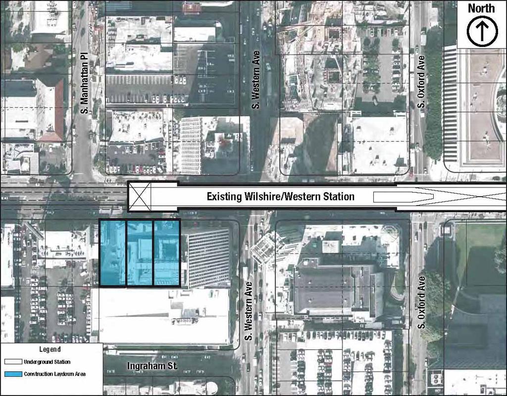
51
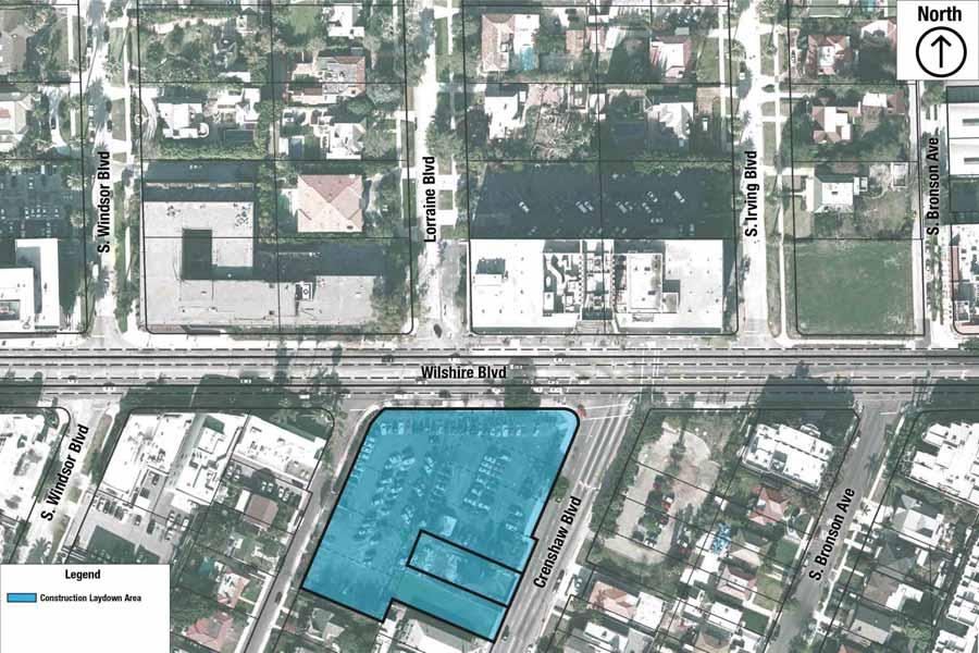
52

53
54
55
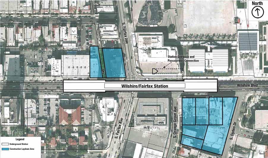
56
57
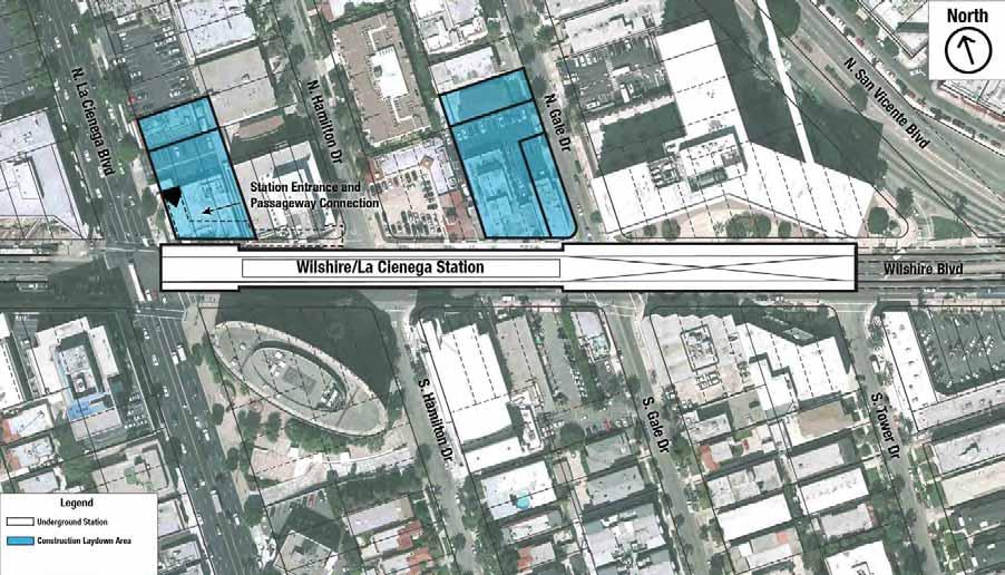
58
59
60
61

62

63
64

65
66
67

68

69
70

71
72
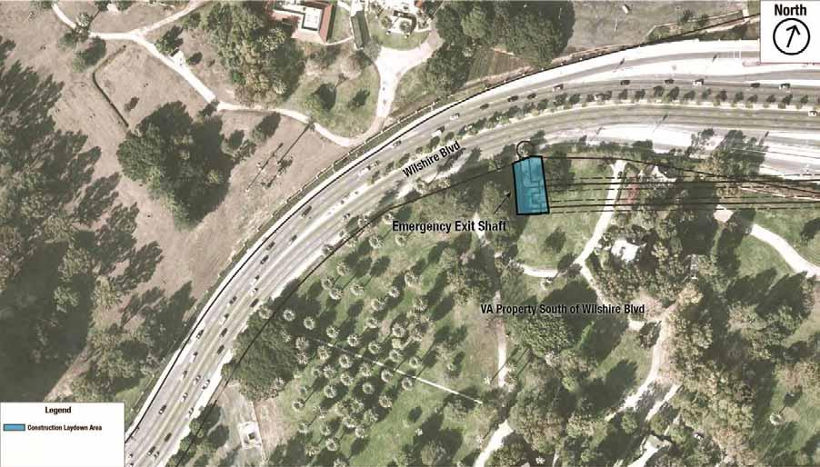
73
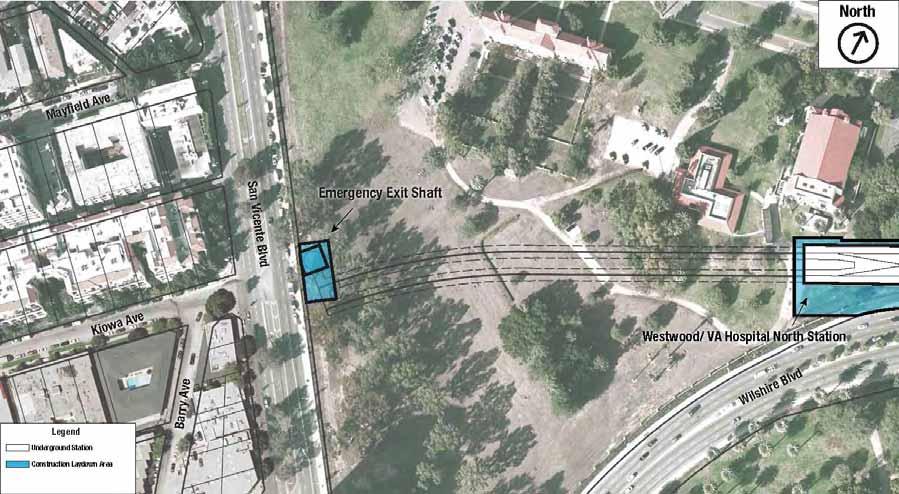
74
Chapter 2 Alternatives Considered
 Beverly Center Area Station Figure 2-54. Santa Monica/San Vicente Station This station would be under San Vicente Boulevard, extending from just south of Gracie Allen Drive to south of Third Street (Figure
Westside Subway Extension Final EIS/EIR. January 2011 Community Update Meetings
 Westside Subway Extension Final EIS/EIR January 2011 Community Update Meetings Purpose of Tonight s Meeting Background information on planning to date Clarify Locally Preferred Alternative (LPA) under
Purple Line Extension Section 1 Construction Community Meeting April 19, 2018
 Purple Line Extension Section 1 Construction Community Meeting April 19, 2018 1 Agenda Section 1 MOW 64 Facility Project Construction Updates: Wilshire/Western Wilshire/La Brea Wilshire/Fairfax Wilshire/La
2.4 Build Alternatives
 Table 2-1. Future Transit Network Changes between No Build and TSM Alternatives Operator Route Group No. Route ID and Description Peak Headway (min) No Build Off-peak Headway (min) Peak Headway (min) TSM
Purple Line Extension Section 1 Construction Community Meeting January 17, 2019
 Purple Line Extension Section 1 Construction Community Meeting January 17, 2019 1 Agenda Section 1 MOW 64 Facility Project Construction Updates: Fossils Project-wide Tunneling Wilshire/Western Wilshire/La
WESTSIDE SUBWAY EXTENSION August 23, 2010 Page 4-61
 4.0 Summary of Construction Methods, Techniques, and Equipment * Figure 4-27: Century City Station to Wilshire/Bundy August 23, 2010 Page 4-61 4.0 Summary of Construction Methods, Techniques, and Equipment
WESTSIDE SUBWAY EXTENSION PROJECT. Updated Off-street Parking Analysis Memorandum
 WESTSIDE SUBWAY EXTENSION PROJECT Updated Off-street Analysis Memorandum April 2011 Table of Contents 1.0 INTRODUCTION... 1 2.0 DATA SOURCE... 1 3.0 OFF-STREET LAND USE & PARKING ANALYSIS... 2 3.1 Station
Purple Line Extension Section 1 Construction Community Meeting January 18, 2018
 Purple Line Extension Section 1 Construction Community Meeting January 18, 2018 1 Agenda Section 1 2017 Accomplishments TBM Art and Naming Contest MOW 64 Facility Project Construction Updates: Wilshire/Western
WESTSIDE SUBWAY EXTENSION. Traffic Analysis Impact Report
 Traffic Analysis Impact Report August 2010 Table of Contents Table of Contents 1.0 INTRODUCTION/SUMMARY...1-1 1.1 Existing (Year 2006) Setting... 1-1 1.2 Future (Year 2035) Setting... 1-2 2.0 PROJECT
Table Existing Traffic Conditions for Arterial Segments along Construction Access Route. Daily
 5.8 TRAFFIC, ACCESS, AND CIRCULATION This section describes existing traffic conditions in the project area; summarizes applicable regulations; and analyzes the potential traffic, access, and circulation
Table of Contents. Visual and Aesthetic Resources Impact Technical Report Table of Contents
 Table of Contents Table of Contents 1.0 INTRODUCTION... 1-1 2.0 PROJECT DESCRIPTION... 2-1 2.1 No Build Alternative... 2-1 2.2 TSM Alternative... 2-1 2.3 Build Alternatives... 2-1 2.3.1 Alternative 1 Westwood/UCLA
Purple Line Extension, Section 2 Southern California Edison, Phase I
 Purple Line Extension, Section 2 Southern California Edison, Phase I 1 Agenda Advance Utility Relocation (AUR) Schedule Southern California Edison (SCE) overview Street Impacts Sunday work: 10am-6pm Left
Purple Line Extension Updates on La Cienega and Rodeo Stations January 10, 2018
 Purple Line Extension Updates on La Cienega and Rodeo Stations January 10, 2018 1 Agenda Project Overview Section 1 Construction Updates 2017 Accomplishments Wilshire/La Cienega Station Decking and Jet
Purple Line Extension, Section 2 Southern California Edison, Phase I June 7, 2017
 Purple Line Extension, Section 2 Southern California Edison, Phase I June 7, 2017 Agenda Advance Utility Relocation (AUR) Schedule Southern California Edison (SCE) overview Street Impacts Sunday work:
WESTSIDE SUBWAY EXTENSION
 Table of Contents Table of Contents 1.0 INTRODUCTION... 1-1 2.0 PROJECT DESCRIPTION... 2-1 2.1 No Build Alternative... 2-1 2.2 TSM Alternative... 2-1 2.3 Build Alternatives... 2-1 2.3.1 Alternative 1 Westwood/UCLA
Purple Line Extension Updates on La Cienega and Rodeo Stations December 13, 2017
 Purple Line Extension Updates on La Cienega and Rodeo Stations December 13, 2017 1 Agenda Project Overview Section 1 Construction Updates Wilshire/La Cienega Station La Cienega Decking Decking Overview
Letter EL652 City of Mercer Island. Page 1. No comments n/a
 Letter EL652 City of Mercer Island Page 1 No comments n/a Page 2 Response to comment EL652 1 Section 4.5.3 of the Final EIS presents the range of potential impacts of the project. This project also lists
Executive Summary. Draft Environmental Impact Statement/Environmental Impact Report ES-1
 Executive Summary Introduction The Eastside Transit Corridor Phase 2 Project is a vital public transit infrastructure investment that would provide a transit connection to the existing Metro Gold Line
Project Scoping Report Appendix B Project Web Site. APPENDIX B Project Web Site
 Project Scoping Report Appendix B Project Web Site APPENDIX B Project Web Site WESTSIDE EXTENSION TRANSIT CORRIDOR STUDY February 4, 2008 News and Info of 1 http://metro.net/projects_programs/westside/news_info.htm#topofpage
Purple Line Extension. Rodeo Station AUR MOA October 24, 2017
 Purple Line Extension Rodeo Station AUR MOA October 24, 2017 1 Agenda Project Overview Section 2 Pre-Construction Updates Rodeo Drive Station Advance Utility Relocation (AUR) SCE Phase I, underway SCE
Appendix H - Response to Comments. March 2012 Page H
 593-1 Your support for Alternative 3 (Santa Monica Extension) has been noted. On October 28, 2010, the Metro Board of Directors identified Alternative 2 (Westwood/VA Hospital Extension) as the Locally
King County Metro. Columbia Street Transit Priority Improvements Alternative Analysis. Downtown Southend Transit Study. May 2014.
 King County Metro Columbia Street Transit Priority Improvements Alternative Analysis Downtown Southend Transit Study May 2014 Parametrix Table of Contents Introduction... 1 Methodology... 1 Study Area...
Expo Light Rail Line Project Status Update Meeting Holman United Methodist Church January 27, 2011
 Project Status Update Meeting Project Status Update Meeting Holman United Methodist Church January 27, 2011 Phase 1 Project Description Phase 1 from Downtown Los Angeles to Culver City: 8.6 mile corridor
Table of Contents. Comparative Benefits and Costs Analysis Table of Contents
 Table of Contents Table of Contents 1.0 INTRODUCTION...1-1 2.0 PROJECT DESCRIPTION...2-1 2.1 No Build Alternative... 2-1 2.2 TSM Alternative... 2-1 2.3 Build Alternatives... 2-1 2.3.1 Alternative 1 Westwood/UCLA
Mobility Corridor Updates. Transit & Active Transportation Projects
 Mobility Corridor Updates Transit & Active Transportation Projects Laura Cornejo, DEO Regional Planner Regional Operator Metro is LA County s Regional Builder/Funder Rail Bus Service (Metro/Muni/Local)
Mobility Corridor Updates. Transit & Active Transportation Projects
 Mobility Corridor Updates Transit & Active Transportation Projects Manjeet Ranu, SEO East San Fernando Valley Transit Corridor Metro Board LPA selection: June 2018 Recently awarded $200 million in Senate
IV. ENVIRONMENTAL IMPACT ANALYSIS N. TRANSPORTATION AND TRAFFIC
 IV. ENVIRONMENTAL IMPACT ANALYSIS N. TRANSPORTATION AND TRAFFIC The following section summarizes the information provided in the traffic report entitled Traffic Impact Analysis for a Proposed Residential
WESTSIDE SUBWAY EXTENSION. Final Smart Growth Evaluation Report
 Final Smart Growth Evaluation Report August 2010 Table of Contents Table of Contents 1.0 INTRODUCTION... 1-1 1.1 4Ds... 1-2 1.2 Direct Ridership Model (DRM)... 1-2 2.0 4DS... 2-1 2.1 Inputs... 2-1 2.2
Location Concept Plan Amendment Recommendation Approved 2011 Concept Plan
 Valley Line West LRT Concept Plan Recommended Amendments Lewis Farms LRT Terminus Site Location Concept Plan Amendment Recommendation Approved 2011 Concept Plan Lewis Farms LRT terminus site, 87 Avenue/West
2.0 Development Driveways. Movin Out June 2017
 Movin Out June 2017 1.0 Introduction The proposed Movin Out development is a mixed use development in the northeast quadrant of the intersection of West Broadway and Fayette Avenue in the City of Madison.
I-405 Sepulveda Pass Improvements Project
 I-405 Sepulveda Pass Improvements Project Community Meeting November 15, 2012 1 Wilshire Segment Overview of Wilshire Segment There are a total of 23 bridges being constructed on this project; almost half
IMPROVEMENT CONCEPTS
 IMPROVEMENT CONCEPTS for the South Novato Transit Hub Study Prepared by: January 11, 2010 DKS Associates With Wilbur Smith Associates IMPROVEMENT CONCEPTS Chapter 1: Introduction 1. INTRODUCTION The strategic
engineering phase and during the procurement of design build contracts.
 CONSIDERATION OF ALTERNATIVES Below-grade trench alignment along Aviation Boulevard, adjacent to LAX south runways. miles. MOS-Century would extend from the Metro Exposition Line to the Aviation/ Century
IV. ENVIRONMENTAL IMPACT ANALYSIS B. TRAFFIC AND CIRCULATION
 IV. ENVIRONMENTAL IMPACT ANALYSIS B. TRAFFIC AND CIRCULATION 1. INTRODUCTION This section is based on the technical report, Traffic Study for 10131 Constellation Boulevard Residential Project, prepared
PAPER FOR AREMA 2006 ANNUAL CONFERENCE LOS ANGELES UNION STATION RUN-THROUGH TRACKS UNION STATION TERMINAL IMPROVEMENTS. Paul Mak, PE, SE HDR Inc
 PAPER FOR AREMA 2006 ANNUAL CONFERENCE LOS ANGELES UNION STATION RUN-THROUGH TRACKS UNION STATION TERMINAL IMPROVEMENTS Paul Mak, PE, SE HDR Inc 801 S. Grand Ave. Suite 500, Los Angeles, CA 90017. Tel
CNG FUELING STATION INITIAL STUDY FULLERTON JOINT UNION HIGH SCHOOL DISTRICT. Appendices
 CNG FUELING STATION INITIAL STUDY FULLERTON JOINT UNION HIGH SCHOOL DISTRICT Appendices Appendix F Parking Study April 2016 CNG FUELING STATION INITIAL STUDY FULLERTON JOINT UNION HIGH SCHOOL DISTRICT
Traffic Management Plan and Queuing Analysis Lakehill Preparatory School Z Hillside Drive, Dallas, TX October 27, 2015
 Traffic Management Plan and Queuing Analysis Lakehill Preparatory School Z145-235 2720 Hillside Drive, Dallas, TX October 27, 2015 Introduction: The Lakehill Preparatory School is located on the northeast
WILSHIRE/RODEO. Westside Subway Extension - DRAFT IMAGES FOR DISCUSSION PURPOSES ONLY. Torti Gallas and Partners, Inc. June SAAG Workshops 2011
 WILSHIRE/RODEO 1 WILSHIRE/RODEO: BANK OF AMERICA FULL PORTAL (OPTION A) Note for Option A: Beverly Drive: Retains 2 northbound & 2 southbound lanes Loss of 40 Bank of America underground parking spaces
Sepulveda Pass Corridor Systems Planning Study
 Los Angeles County Metropolitan Transportation Authority Sepulveda Pass Corridor Systems Planning Study Streets and Freeways Subcommittee January 17, 2013 1 Sepulveda Pass Study Corridor Extends for 30
RECOMMENDATION PAPER TO THE DULLES CORRIDOR COMMITTEE
 DULLES RAIL RECOMMENDATION PAPER TO THE DULLES CORRIDOR COMMITTEE ANALYSIS OF ALTERNATIVE AIRPORT ALIGNMENTS FOR METRORAIL AT WASHINGTON DULLES INTERNATIONAL AIRPORT MARCH 2011 PURPOSE This paper presents
Exposition Corridor Transit Project
 Exposition Corridor Transit Project Phase 2 Environmental Planning Community Meeting June 9, 2008 Exposition Corridor Transit Project Phase 2 AGENDA Remaining Grade Crossing Recommendations June 9, 2008
4.1 Traffic, Circulation, and Parking
 4.1 Traffic, This section describes the existing transportation and parking conditions within and adjacent to the project area. A traffic report describing the potential impacts of the proposed project
Construction Staging Area 4 Avenue Road
 REPORT FOR ACTION Construction Staging Area 4 Avenue Road Date: September 27, 2017 To: Toronto and East York Community Council From: Acting Director, Transportation Services, Toronto and East York District
Highway 18 BNSF Railroad Overpass Feasibility Study Craighead County. Executive Summary
 Highway 18 BNSF Railroad Overpass Feasibility Study Craighead County Executive Summary October 2014 Highway 18 BNSF Railroad Overpass Feasibility Study Craighead County Executive Summary October 2014 Prepared
T-THIRD PHASE 3 CONCEPT STUDY C: DETAILED DESCRIPTIONS OF CONCEPT ALIGNMENTS D: CONSTRUCTABILITY ANALYSIS AND COST ESTIMATES (HNTB CONSULTANTS)
") A: 2014 SFMTA TRANSIT SERVICE INFORMATION B: SFMTA TRAFFIC COUNT DATA C: DETAILED DESCRIPTIONS OF CONCEPT ALIGNMENTS D: CONSTRUCTABILITY ANALYSIS AND COST ESTIMATES (HNTB CONSULTANTS) E: LAND USE AND VALUE
A: 2014 SFMTA TRANSIT SERVICE INFORMATION B: SFMTA TRAFFIC COUNT DATA C: DETAILED DESCRIPTIONS OF CONCEPT ALIGNMENTS D: CONSTRUCTABILITY ANALYSIS AND COST ESTIMATES (HNTB CONSULTANTS) E: LAND USE AND VALUE
FINAL. Sound Transit Long-Range Plan Update. Issue Paper S.1: Tacoma Link Integration with Central Link. Prepared for: Sound Transit
 Sound Transit Long-Range Plan Update Issue Paper S.1: Tacoma Link Integration with Central Link Prepared for: Sound Transit Prepared by: Quade & Douglas, Inc. FINAL March 2005 Foreword This issue paper
The major roadways in the study area are State Route 166 and State Route 33, which are shown on Figure 1-1 and described below:
 3.5 TRAFFIC AND CIRCULATION 3.5.1 Existing Conditions 3.5.1.1 Street Network DRAFT ENVIRONMENTAL IMPACT REPORT The major roadways in the study area are State Route 166 and State Route 33, which are shown
Crenshaw-Prairie Transit Corridor Study Public Meetings
 Crenshaw-Prairie Transit Corridor Study Public Meetings Darby Park: Wednesday, February 20, 2008 6:30 8:00 PM US Bank Community Room: Thursday, February 21, 2008 6:30 8:00 PM Nate Holden Performing Arts
Escondido Marriott Hotel and Mixed-Use Condominium Project TRAFFIC IMPACT ANALYSIS REPORT
 Escondido Marriott Hotel and Mixed-Use Condominium Project TRAFFIC IMPACT ANALYSIS REPORT Prepared for Phelps Program Management 420 Sixth Avenue, Greeley, CO 80632 Prepared by 5050 Avenida Encinas, Suite
Westside Subway Extension Draft Environmental Impact Statement/ Environmental Impact Report
 Los Angeles County Metropolitan Transportation Authority Westside Subway Extension Draft Environmental Impact Statement/ Environmental Impact Report > Executive Summary September 2010 The U.S. Department
PAPER FOR AREMA 2004 ANNUAL CONFERENCE LOS ANGELES UNION STATION RUN-THROUGH TRACKS. Paul Mak, PE, SE - DMJM HARRIS
 1 PAPER FOR AREMA 2004 ANNUAL CONFERENCE LOS ANGELES UNION STATION RUN-THROUGH TRACKS Paul Mak, PE, SE - DMJM HARRIS 515 S. Flower Street 9th Floor, Los Angeles, CA 90071. Tel 213-593-8337 Fax 213-593-8622
Traffic Engineering Study
 Traffic Engineering Study Bellaire Boulevard Prepared For: International Management District Technical Services, Inc. Texas Registered Engineering Firm F-3580 November 2009 Executive Summary has been requested
SOUTH ACCESS TO THE GOLDEN GATE BRIDGE DOYLE DRIVE DOYLE DRIVE. Doyle Drive Presentation Golden Gate Bridge Board Meeting July 24, 2009
 DOYLE DRIVE Doyle Drive Presentation Golden Gate Bridge Board Meeting July 24, 2009 Presentation Overview Introduction Project Acceleration Construction Contracts Construction Activities Lane and Road
ATTACHMENT [B] PROJECT DESCRIPTION REQUESTED CITY OF LOS ANGELES ACTIONS
![ATTACHMENT [B] PROJECT DESCRIPTION REQUESTED CITY OF LOS ANGELES ACTIONS](/thumbs/72/67299149.jpg "ATTACHMENT [B] PROJECT DESCRIPTION REQUESTED CITY OF LOS ANGELES ACTIONS") ATTACHMENT [B] PROJECT DESCRIPTION REQUESTED CITY OF LOS ANGELES ACTIONS I. Project Location The Los Angeles International Airport (LAX) Landside Access Modernization Program ( Project ) comprises approximately
ATTACHMENT [B] PROJECT DESCRIPTION REQUESTED CITY OF LOS ANGELES ACTIONS I. Project Location The Los Angeles International Airport (LAX) Landside Access Modernization Program ( Project ) comprises approximately
5.9 TRANSPORTATION AND TRAFFIC
 5.9 TRANSPORTATION AND TRAFFIC This section evaluates transportation- and traffic-related impacts that have the potential to result from the construction and operation of the Project. Information and analysis
Diablo Vista Pumping Plant Replacement
 Diablo Vista Pumping Plant Replacement Traffic Study PHA Transportation Consultants 12-05-359 October 2012 Diablo Vista Pumping Plant Replacement Traffic Study For EBMUD October 2012 PHA Transportation
Preliminary Definition of Alternatives. 3.0 Preliminary Definition of Alternatives
 3.0 What preliminary alternatives are being evaluated? The alternatives for the East San Fernando Valley Transit Corridor project that were considered for screening include the No Build Alternative, Transportation
ANDERSON PROPERTY SITE ANALYSIS
 ANDERSON PROPERTY SITE ANALYSIS Introduction The Montgomery County Department of Transportation (MCDOT) initiated a feasibility study in the fall of 2012 to evaluate the need for transit service expansion
Mercer Island Center for the Arts Parking Management Plan
 Parking Stalls Mercer Island Center for the Arts Parking Management Plan June 15, 2016 This Parking Management Plan (P) covers all tenants at the Mercer Island Center for the Arts (MICA) campus, including
Sound Transit East Link: Bus/LRT System Integration Study
 Sound Transit East Link: Bus/LRT System Integration Study Prepared For: Sound Transit King County Metro Mercer Island WSDOT Prepared By: CH2M HILL July, 2014 1 SOUND TRANSIT EAST LINK: BUS/LRT SYSTEMES
Study Area, Related Projects and Travel Markets
 Study Area, Related Projects and Travel Markets Study area and related projects Travel between Valley and Westside North San Fernando Valley BRT (Alignment TBD) East San Fernando Valley Transit Corridor
3.14 Parks and Community Facilities
 3.14 Parks and Community Facilities 3.14.1 Introduction This section identifies the park and community facility resources in the study area and examines the potential impacts that the proposed Expo Phase
Dallas CBD Second Light Rail Alignment (D2)
") Dallas CBD Second Light Rail Alignment (D2) Subway Project Refinement Stakeholder Meeting December 7, 2016 Discussion Items Background Schedule Public/Stakeholder Involvement Comments/Questions from Audience
Dallas CBD Second Light Rail Alignment (D2) Subway Project Refinement Stakeholder Meeting December 7, 2016 Discussion Items Background Schedule Public/Stakeholder Involvement Comments/Questions from Audience
2. Valley Circle Boulevard/Andora Avenue/Baden Avenue and Lassen Street
 IV.J TRANSPORTATION 1. INTRODUCTION This section presents an overview of the existing traffic and circulation system in and surrounding the project site. This section also discusses the potential impacts
Kendall Drive Premium Transit PD&E Study Project Kick-Off Meeting SR 94/Kendall Drive/SW 88 Street Project Development and Environment (PD&E) Study
 Study") Florida Department of Transportation District Six Kendall Drive Premium Transit PD&E Study Project Kick-Off Meeting SR 94/Kendall Drive/SW 88 Street Project Development and Environment (PD&E) Study What
Florida Department of Transportation District Six Kendall Drive Premium Transit PD&E Study Project Kick-Off Meeting SR 94/Kendall Drive/SW 88 Street Project Development and Environment (PD&E) Study What
FREQUENTLY ASKED QUESTIONS
 THE PROJECT Last updated on 2/19/16 FREQUENTLY ASKED QUESTIONS What s happening on Highway 169? The Minnesota Department of Transportation (MnDOT) is planning to rebuild and repair the infrastructure on
Summary of the Alcoa Highway Redevelopment Project
 Appendix B Summary of the Alcoa Highway Redevelopment Project By Marcia Finfer, October 2009 The Timberlake community, along with numerous other concerned citizen groups (including the Lakemoor Hills community)
Table of Contents INTRODUCTION... 3 PROJECT STUDY AREA Figure 1 Vicinity Map Study Area... 4 EXISTING CONDITIONS... 5 TRAFFIC OPERATIONS...
 Crosshaven Drive Corridor Study City of Vestavia Hills, Alabama Table of Contents INTRODUCTION... 3 PROJECT STUDY AREA... 3 Figure 1 Vicinity Map Study Area... 4 EXISTING CONDITIONS... 5 TRAFFIC OPERATIONS...
Restoration of Historic Streetcar Services in Downtown Los Angeles
 Restoration of Historic Streetcar Services in Downtown Los Angeles Alternatives Analysis Community Update Meeting August 2, 2011 Introduction Key players Local lead agency: Metro Federal lead agency: Federal
Midtown Corridor Alternatives Analysis Capital Cost Estimation Methodology and Assumptions
 Midtown Corridor Alternatives Analysis Capital Cost Estimation Methodology and Assumptions 1/3/2014 Prepared by the SRF Consulting Group Team for Table of Contents Introduction... 1 Alternatives Overview...
FREQUENTLY ASKED QUESTIONS
 THE PROJECT Last updated on 9/8/16 FREQUENTLY ASKED QUESTIONS What s happening on Highway 169? The Minnesota Department of Transportation (MnDOT) is planning to rebuild and repair the infrastructure on
Click to edit Master text styles
 I-405 Sepulveda Pass Improvements Project Quarterly Community Meeting November 17, 2011 1 Wilshire Segment 2 Quarterly Community Meetings 2012 Month Meeting(s) February 16 May 17 Quarterly Quarterly August
King Soopers #116 Thornton, Colorado
 Traffic Impact Study King Soopers #116 Thornton, Colorado Prepared for: Galloway & Company, Inc. T R A F F I C I M P A C T S T U D Y King Soopers #116 Thornton, Colorado Prepared for Galloway & Company
TRAFFIC PARKING ANALYSIS
 TRAFFIC PARKING ANALYSIS NAPA FLEA MARKET COUNTY OF NAPA Prepared for: Tom Harding Napa-Vallejo Flea Market 33 Kelly Road American Canyon, CA 9453 Prepared by: 166 Olympic Boulevard, Suite 21 Walnut Creek,
TRANSPORTATION STUDY FOR THE 8899 BEVERLY BOULEVARD PROJECT
 DRAFT TRANSPORTATION STUDY FOR THE 8899 BEVERLY BOULEVARD PROJECT WEST HOLLYWOOD, CALIFORNIA NOVEMBER 2013 PREPARED FOR BEVERLY BOULEVARD ASSOCIATION PREPARED BY DRAFT TRANSPORTATION STUDY FOR THE 8899
Sherman Oaks Community Traffic Plan
 Sherman Oaks is a community that is geographically bound by the Santa Monica mountains on its southern boundary, and the ever-expanding San Fernando Valley on its western, northern, and eastern boundaries.
Construction Realty Co.
 MEMORANDUM TO: FROM : Jeff Pickus Construction Realty Co. Luay R. Aboona, PE Principal 9575 West Higgins Road, Suite 400 Rosemont, Illinois 60018 p: 847-518-9990 f: 847-518-9987 DATE: May 22, 2014 SUBJECT:
Sepulveda Pass Corridor Systems Planning Study Update
 Los Angeles County Metropolitan Transportation Authority Sepulveda Pass Corridor Systems Planning Study Update June 20, 2012 Measure R Transit Corridors One of 12 Measure R Transit Corridors approved by
APPENDIX C-2. Traffic Study Supplemental Analysis Memo
 APPENDIX C-2 Traffic Study Supplemental Analysis Memo The Mobility Group Transportation Strategies & Solutions Memorandum To: From: Subject: Tomas Carranza, LADOT Matthew Simons Traffic Review - Revised
Madison BRT Transit Corridor Study Proposed BRT Operations Plans
 Madison BRT Transit Corridor Study Proposed BRT Operations Plans This paper presents a description of the proposed BRT operations plan for use in the Madison BRT Transit Corridor Study. The objective is
I-405 Sepulveda Pass Improvements Project
 I-405 Sepulveda Pass Improvements Project 26, 2012 Click to edit Master title January style Community Advisory Committee 1 Community Meeting Schedule for 2012 26-Jan CAC, Final Meeting Feb 22-Mar Community
TRAFFIC IMPACT STUDY. USD #497 Warehouse and Bus Site
 TRAFFIC IMPACT STUDY for USD #497 Warehouse and Bus Site Prepared by: Jason Hoskinson, PE, PTOE BG Project No. 16-12L July 8, 216 145 Wakarusa Drive Lawrence, Kansas 6649 T: 785.749.4474 F: 785.749.734
30-Day Look Ahead Summary August 2011
 Wilshire Segment 30-Day Look Ahead Summary August 2011 DWP and SCE Utility Relocation Sepulveda reduced to one lane in each direction, Constitution to Ohio, 9pm to 6am Westbound Wilshire reduced to one
4.0 TIER 2 ALTERNATIVES
 4.0 TIER 2 ALTERNATIVES The Tier 2 Alternatives represent the highest performing Tier 1 Alternatives. The purpose of the Tier 2 Screening was to identify the LPA utilizing a more robust list of evaluation
Countdown to the Closure Extended 53-Hour Closure of I-405 Freeway Between U.S. 101 and I-10 Planned in Mid-July for Mulholland Bridge Demolition
 Countdown to the Closure Extended 3-Hour Closure of I-40 Freeway Between U.S. 0 and I-0 Planned in Mid-July for Mulholland Bridge Demolition Work Los Angeles, Calif. Plan Ahead, Avoid The Area, Or Stay
REGIONAL TRANSPORTATION SETTING
 CIRCULATION ELEMENT WHITE PAPER NO. 1 REGIONAL TRANSPORTATION SETTING INTRODUCTION According to the Southern California Association of Governments (SCAG), by 2030 the six- County region will be home to
Restoration of Historic Streetcar Services in Downtown Los Angeles
 Restoration of Historic Streetcar Services in Downtown Los Angeles Early Scoping Meeting for Alternatives Analysis (AA) May 17, 2011 Introduction Key players Local lead agency: Metro Federal lead agency:
Trip Generation & Parking Occupancy Data Collection: Grocery Stores Student Chapter of Institute of Transportation Engineers at UCLA Spring 2014
 Trip Generation & Parking Occupancy Data Collection: Grocery Stores Student Chapter of Institute of Transportation Engineers at UCLA Spring 2014 Page 1 Introduction The UCLA Institute of Transportation
IV. ENVIRONMENTAL IMPACT ANALYSIS M. TRANSPORTATION AND TRAFFIC
 IV. ENVIRONMENTAL IMPACT ANALYSIS M. TRANSPORTATION AND TRAFFIC INTRODUCTION This section of the (Draft EIR) addresses the subject of traffic and transportation with respect to the proposed (Project or
THE WILSHIRE CORRIDOR: RAIL AND ITS ALTERNATIVES. Prepared By: Jacki Murdock Transportation and Environmental Planner
 THE WILSHIRE CORRIDOR: RAIL AND ITS ALTERNATIVES Prepared By: Jacki Murdock Transportation and Environmental Planner December 13 th, 2012 Overview Characteristics of Wilshire Boulevard Overview of the
Project Status Update January 2017
 Project Status Update January 2017 1 What is the Purple Line? A new 16 mile east-west light rail line Operates mostly on the surface with 21 stations Connects New Carrollton in Prince George s County and
This letter summarizes our observations, anticipated traffic changes, and conclusions.
 Mr. David Jorschumb Project Manager Boulder Valley School District Re: Review of proposed school access improvements at the Foothills Elementary School in Boulder Dear Mr. Jorschumb, At your request, the
East San Fernando Valley Transit Corridor. TAC Briefing December 4, 2013
 East San Fernando Valley Transit Corridor TAC Briefing December 4, 2013 Overview Measure R Project Long Range Transportation Plan Reserves $170.1 Million 2018 Revenue Operations Date Coordination with
Develop ground transportation improvements to make the Airport a multi-modal regional
 Project Overview TRANSPORTATION IMPROVEMENTS WHAT ARE THE PROJECT GOALS? Transportation transportation hub. Develop ground transportation improvements to make the Airport a multi-modal regional Land Use
INDUSTRIAL DEVELOPMENT
 INDUSTRIAL DEVELOPMENT Traffic Impact Study Plainfield, Illinois August 2018 Prepared for: Seefried Industrial Properties, Inc. TABLE OF CONTENTS Executive Summary 2 Introduction 3 Existing Conditions
Chapter 9 Recommended Locally Preferred Alternative and Alternatives for Evaluation in Draft SEIS/SEIR
 Chapter 9 Recommended Locally Preferred Alternative and Alternatives for Evaluation in Draft SEIS/SEIR 9.0 RECOMMENDED LOCALLY PREFERRED ALTERNATIVE AND ALTERNATIVES FOR EVALUATION IN DRAFT SEIS/SEIR
Addendum No. 2 to Supplemental Environmental Impact Statement/ Supplemental Environmental Impact Report
 Addendum No. 2 to Supplemental Environmental Impact Statement/ Supplemental Environmental Impact Report REMARKS Addendum Date: Case No.: 1996.281E_13 Project Title: - Phase 2 of the Third Street Light
Appendix G Traffic and Parking Report
 Appendix G Traffic and Parking Report TABLE OF CONTENTS SECTION PAGE Executive Summary... v 1.0 Introduction... 1 1.1 Study Area... 3 2.0 Project Description... 4 2.1 Site Location... 4 2.2 Existing Project
II. PROJECT DESCRIPTION
 II. PROJECT DESCRIPTION A. PROJECT APPLICANT The project applicants for the proposed Sepulveda/Rosecrans Site Rezoning are: Mar Ventures, Inc., 2050 West 190 th Street, Suite 108, Torrance, California,
800 Access Control, R/W Use Permits and Drive Design
 Table of Contents 801 Access Control... 8-1 801.1 Access Control Directives... 8-1 801.2 Access Control Policies... 8-1 801.2.1 Interstate Limited Access... 8-1 801.2.2 Limited Access... 8-1 801.2.3 Controlled