Taylor s Falls Business Park
|
|
|
- Todd Haynes
- 5 years ago
- Views:
Transcription

1 Site Information Taylor s Falls Business Park County Road 37, Taylors Falls, MN Chisago County HRA-EDA 12/23/2014


2 Taylors Falls Business Park County Road 37 Taylors Falls, MN PROPERTY FEATURES: Zoned Commercial/Industrial Full Municipal Utilities In Place Located Just 50 Miles North of Twin Cities Land for $1.00, Includes All Assessments Lots Sized For Your Business Needs Business Friendly Development Process Plenty of Room For Expansions AVAILABLE AREA: 10 Acres Divisible 2
3 TABLE OF CONTENTS CONTACT INFORMATION 4 -Owner -Realtor - More Info/Marketing PARCELS..5 -Block One -Block Two -Outlots LAND USE & ZONING.9 -Land Use -Current and Planned Zoning - Zoning Map - Permits - Zoning Ordinance TRANSPORTATION..13 -Chisago County Highway Map -Location & Distances - Ports & Airports -Rail Access -County Rail Access - Traffic Counts UTILITIES Electric -Natural Gas - Telecommunications - Water & Sewer ENVIRONMENTAL Contact Information -Soils Map -Wetlands Map - Floodplains Map - Elevation Map EASEMENTS..28 FINANCIAL RESOURCES
4 CONTACT INFORMATION OWNER City of Taylors Falls th Street Taylors Falls, MN Contact: Jo Everson Phone: Web: LISTING REALTOR MORE INFO/MARKETING Chisago County HRA/EDA th Avenue North Branch, MN Contact: Nancy Hoffman Phone: Web: 4


5 PARCELS BLOCK ONE Lot 1 PIN: Acres: 0.85 Square Feet: 36,595 Lot 2 PIN: Acres: Square Feet: 7,907 5


6 BLOCK TWO Lot 1 PIN: Acres: 1.42 Square Feet: 61,696 Lot 2 PIN: Acres: 1.42 Square Feet: 61,947 6


7 OUT-LOTS Outlot A PIN: Acres: 1.52 Square Feet: 65,852 Outlot C PIN: Acres: 2.52 Square Feet: 109,485 7

8 Outlot B PIN: Acres: 8.87 Square Feet: 386,377 8
9 LAND USE & ZONING LAND USE: Previous Uses of Site: Unused Current and previous uses of adjacent parcels: Farmstead to the West, Electrical Substation to the East CURRENT AND PLANNED ZONING: Current and planned zoning designation for the site: Current: B+I- Business and Industrial Planned: B+I- Business and Industrial Current zoning designations for land within 500 feet of the site: RC- Rural Countryside RT- Residential Transitional Shafer Township- AG- Agriculture 9

10 ZONING MAP Zoning Map- PDF 10
11 PERMITS Building Permit- PDF 11
12 ZONING ORDINANCE Zoning Ordinance- City of Taylors Falls 12

13 TRANSPORTATION Chisago County Highway Map CHISAGO COUNTY HIGHWAY MAP 13
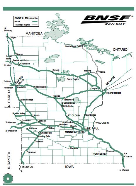
14 LOCATION AND DISTANCES Location to nearest major highway: 2 miles to Highway 8 2 miles to Highway 95 Distance to closest north/south interstate highway: 26 miles to I-35 in Forest Lake, MN Distance to closest east/west interstate highway: 40 miles to I-694 Distance to Minneapolis: 50 miles PORTS & AIRPORTS Does the site have access to a navigable river, inland or seat port? No Distance to closest port: 47 miles to Port of St. Paul 50 miles to Port of Minneapolis 130 miles to Port of Duluth Distance to closest international airport: 48 miles to Minneapolis/St. Paul International Airport Distance to local/regional airports: L.O Simenstad Municipal Airport: 11 miles Osceola, WI 5,000 ft runway Navigational Aids: Beacon Rush City, MN Regional Airport: 33 miles 4,400 ft runway Navigational Aids: Beacon RAIL ACCESS Does the site have access to rail? No Distance to closest rail: North Branch, MN: 20 miles BNSF Rail St. Paul, MN: 47 miles Intermodal Facility 14

15 CHISAGO COUNTY RAIL ACCESS 15
16 16
17 TRAFFIC COUNTS INFORMATION FROM MNDOT C.R. 37: 1,550 daily traffic counts 17
18 UTILITIES ELECTRIC POWER PROVIDERS AND SERVICE DESCRIPTION XCEL ENERGY Contact Name: Colette Jurek Address: 1700 East County Road E City/State/Zip: White Bear Lake, MN Phone: Fax: Colette.c.jurek@xcelenergy.com Is three-phase electric service currently at or within the boundary of this site? Yes Voltages available: 34.5 kv Is existing service overhead or underground: Overhead Is a loop (underground loop with two different delivery points) available at this site? It can be built What is the approximate distance to the nearest substation servicing this site? Next to site Is there potential for dual feed to the site from two different substations? Yes at a cost What is the largest demand that can be served at this site using existing system? Xcel Energy cannot release this information 18
19 NATURAL GAS PROVIDERS AND SERVICE DESCRIPTION Xcel Energy Contact Name: Collette Jurek Phone: Fax: Address: 1700 East County Road E City/State/Zip: White Bear Lake, MN Colette.c.jurek@xcelenergy.com Is there natural gas service currently available at the site? Yes If yes, what is the natural gas line size to the site? 2 inches, 6 inch main within 800 feet Line Capacity: Xcel Energy cannot release this information Pressure (PSI): 60 PSI 19
20 TELECOMMUNICATIONS PROVIDERS AND SERVICE DESCRIPTION Contact Name: Steve Johnson, Business Development Manager Company: Midcontinent Communications Business Solutions Address: 402 N Red River Ave, Suite 5 City/State/Zip: Cold Spring, MN Phone: steve_johnson@mmi.net Is there telecommunications service currently available at this site? No- but is passing by on the road Does the site have broadband service? No- but is passing by on the road If there is broadband service, what is the upstream bandwidth? Mbps What is the downstream broadband width? Mbps What is the type of delivery medium? Fiber If service is not available, how soon can it be installed? Days Contact Name: Mike Konop Company: Frontier Communications Address: st Avenue N City/State/Zip: Lindstrom, MN Phone: mike.konop@ftr.com Is there telecommunications service currently available at this site? No-but is passing by on the road Does the site have broadband service? No- but is passing by on the road If there is broadband service, what is the upstream bandwidth? 6 Mbps (Higher on ICB) What is the downstream broadband width? 24 Mbps (Higher on ICB) What is the type of delivery medium? Access to both copper and fiber. Not presently in the development. If service is not available, how soon can it be installed? 3-4 weeks after firm order 20
21 WATER & SEWER Municipality: City of Taylors Falls Address: st Street City/State/Zip: Taylors Falls, MN Phone: WATER Head pressure at closest hydrant: 80 PSI Flow rate at nearest hydrant: 1000 GPM Attach chemical profile of water: No Is water from surface or groundwater source? Ground (2 wells) Is water source part of looped system with feed from two sources? Yes Any planned upgrades, if so, when? No SEWER Sewer line in place near/at site? Yes Diameter of line at site: 8 inches Depth of sewer in public right-of-way: 8 inches Size of sewer main in public right-of-way? 9 feet Any special pre-treatment? No Any incremental treatment capacity planned? If yes, note additional capacity: No 21
22 STORM SEWER Any additional storm water treatment or rate of discharge control required for this site? No MPCA MS4 (SMALL SEPARATE STORM SEWER SYSTEMS) PROGRAM COMPLIANCE Are you required to obtain permit coverage for storm water discharges? No Have you satisfied the MS4 permit conditions to develop/implement storm management program and report on status/effectiveness? Are you required to obtain a NPDES (National Pollutant Discharge Elimination System) permit for storm water during construction? No If yes, have you prepared a Storm Water Pollution Prevention Plan (SWPPP) for erosion prevention/sediment control? 22
23 ENVIRONMENTAL CONTACT INFORMATION Chisago County Soil and Water Conservation District Contact: Craig Mell rd Ave North Branch, MN craig.mell@mn.nacdnet.net Chisago County Environmental Services Contact: Kurt Schneider 313 N Main Street, Room 243 Center City, MN kmschne@co.chisago.mn.us 23

24 SOILS MAP Chisago County. (n.d.). Interactive Map. Retrieved December 1, 2014, from Soil Descriptions: 346- Nebish loam, 2 to 6 percent slopes Drainage Class: Well Drained Permeability: Moderate Available water capacity: High Organic matter content: Moderately low Surface runoff: Medium Depth to the water table: More than 6 feet 678- Beltrami loam, thick solum Drainage Class: Somewhat poorly drained Permeability: Moderate Available water capacity: High Organic Matter Content: Moderate Surface runoff: Slow Depth to the water table: 2 to 4 feet 40B- Nebish loam, 2 to 6 percent slopes Drainage Class: Well Drained Permeability: Moderate Available water capacity: High Organic matter content: Moderately low Surface runoff: Medium Depth to the water table: More than 6 feet 24
25 WETLANDS MAP Chisago County. (n.d.). Interactive Map. Retrieved December 29, 2014, from 25
26 FLOODPLAINS MAP Chisago County. (n.d.). Interactive Map. Retrieved December 29, 2014, from 26

27 ELEVATION MAP MN DNR. (n.d.). MnTOPO. Retrieved December 1, 2014, from 27
28 EASEMENTS 28
29 FINANCIAL RESOURCES Chisago County HRA/EDA Resources 29
PADUCAH TRIPLE RAIL SPEC BUILDING. Paducah, McCracken County, Kentucky N W. Paducah Triple Rail Spec Building
 PADUCAH TRIPLE RAIL SPEC BUILDING 37 05 17.5308 N -88 42 8.9886 W I TABLE OF CONTENTS III. Aerial Map IV. Infrastructure Map V. Regional Map VI. Local Map VII. Street Map VIII. Interior Photo 1 IX. Interior
Table of Contents PRIME INDUSTRIAL LAND. Arrowhead Drive /- acres Carson City, Nevada. For Sale $3.95 / SF
 Arrowhead Dr., Carson City, NV Table of Contents Property Description...2 Lot Information...3 Lot Area Maps...4 Parcel Map...5 Powerline Map...6 Site Vicinity...7 Water & Sewer Lines...8 Test Pit Location...9
Commercial Industrial Land Available
 Commercial Industrial Land Available PID: 200970010 List Price $744,292 Price Per Square Foot: $3.00 Sq. Ft. Property Details Street Address: Laredo St. & South St. Parcel ID: 200970010 City: Belle Plaine
Plan and Profile for the Black Dog Natural Gas Pipeline Project Docket No. G002/GP
 414 Nicollet Mall Minneapolis, MN 55401 March 13, 2017 Daniel P. Wolf Executive Secretary Minnesota Public Utilities Commission 121 7 th Place East, Suite 350 St. Paul, MN 55101 Via Electronic Filing RE:
Purpose and Need Report
 Purpose and Need Report State Highway (SH) 29 From Southwestern Boulevard to SH 95 Williamson County, Texas (CSJ: 0337-02-045) Prepared by Blanton & Associates, Inc. Date: November, 2015 The environmental
A Salt Marsh Advancement Zone Assessment of Greenwich, Connecticut
 A Salt Marsh Advancement Zone Assessment of Greenwich, Connecticut Front cover image: Open space and unprotected parcels critical to the conservation of marsh advancement corridors in Greenwich; from the
CROW WING COUNTY HIGHWAY DEPARTMENT APPLICATION FOR PERMIT TO CONSTRUCT DRIVEWAY ACCESS TO ROADS UNDER COUNTY JURISDICTION CONSTRUCTION INFORMATION
 CROW WING COUNTY HIGHWAY DEPARTMENT APPLICATION FOR PERMIT TO CONSTRUCT DRIVEWAY ACCESS TO ROADS UNDER COUNTY JURISDICTION Crow Wing County Highway Department 16589 CR 142 Brainerd, MN 56401 Crow Wing
Beneficial Use Designations for Stream Reaches: Lower St. Croix River Watershed ( )
") Beneficial Use Designations for Stream Reaches: Lower St. Croix River Watershed (07030005) Beneficial Use Legend 1A Domestic Consumption (does not require treatment) 1B Domestic Consumption (requires moderate
Beneficial Use Designations for Stream Reaches: Lower St. Croix River Watershed (07030005) Beneficial Use Legend 1A Domestic Consumption (does not require treatment) 1B Domestic Consumption (requires moderate
INDUSTRIAL DEVELOPMENT SITE DLH PARCEL #34 +/ GROSS ACRES DLH PARCELS #114 & #115 +/ GROSS ACRES
 INDUSTRIAL DEVELOPMENT SITE DLH PARCEL #34 +/- 55.39 GROSS ACRES DLH PARCELS #114 & #115 +/- 133.36 GROSS ACRES YOUR GATEWAY TO GLOBAL DISTRIBUTION LANCASTER-HUTCHINS ROAD HUTCHINS, TEXAS DLH PARCEL #34
DRIVEWAY/APPROACH PERMIT APPLICATION Applicant Type: Architect/Engineer Contractor Owner
 DRIVEWAY/APPROACH PERMIT APPLICATION Applicant Type: Architect/Engineer Contractor Owner Lake Elmo City Hall 651-747-3900 3880 Laverne Avenue North Lake Elmo, MN 55042 Project Address: Property Owner:
FEASIBILITY REPORT. 65 th STREET TRUNK WATER MAIN IMPROVEMENTS INVER GROVE HEIGHTS MINNESOTA DAKOTA COUNTY. October 2, 2017
 FEASIBILITY REPORT 65 th STREET TRUNK WATER MAIN IMPROVEMENTS INVER GROVE HEIGHTS MINNESOTA DAKOTA COUNTY October 2, 2017 Prepared for: City of Inver Grove Heights 8150 Barbara Avenue Inver Grove Heights,
VACANT LAND FOR SALE: 20.4 Acres
 To Minneapolis > McDonalds U.S. Hwy 169 Enterprise Dr. Coborn s < To Mankato Cambria Matt Saxe Chevrolet Buick Hickory Blvd. This property is ideally located near the U.S. Highway 169 interchange in Belle
Summary of Current Corridor Alternatives. January 4, 2012
 Summary of Current Corridor Alternatives January 4, 2012 INITIAL CORRIDORS FOR ANALYSIS (grouped by corridor families ) P-1 P-2 P-3 P-4 T-5 T-6 T-7 Pleasant Hill Road Family Tennessee Avenue Family M-8
Project Home - Sites in Central Pennsylvania
 5 Project Home - Sites in Central Pennsylvania Property Report (SEEDCO INDUSTRIAL PARK) Availability For Sale Sale Price $24,000.00 For Lease Sale Price Comments KOZ & KOEZ Sites $23,000 - $25,000/acre
PRELIMINARY UTILITY REPORT FOR TOPGOLF INTERNATIONAL, INC.
 PRELIMINARY UTILITY REPORT FOR TOPGOLF INTERNATIONAL, INC. THORNTON, COLORADO Prepared for: ARCO Murray Contact: Rachel Bohac Phone: 331.251.2726 Prepared by: 1225 17 th Street, Suite 514 Denver, CO 80202
747 ACRES LAND FOR SALE
 747 ACRES LAND FOR SALE 3400 NORTH PONY EXPRESS PARKWAY, EAGLE MOUNTAIN, UTAH 84005 Salt Lake Count y Lehi 73 Sar atoga Spring s Eagle Mountain Blvd g Eagle Mountain Eagle Mountain Blvd Pony Express Pkwy
Effective [one year after date of adoption] the provisions of this rule shall apply to:
![Effective [one year after date of adoption] the provisions of this rule shall apply to:](/thumbs/87/96358654.jpg "Effective [one year after date of adoption] the provisions of this rule shall apply to:") VENTURA COUNTY AIR POLLUTION CONTROL DISTRICT RULE 55.1 PAVED ROADS AND PUBLIC UNPAVED ROADS (Adopted / / ) A. Applicability Effective [one year after date of adoption] the provisions of this rule shall
VENTURA COUNTY AIR POLLUTION CONTROL DISTRICT RULE 55.1 PAVED ROADS AND PUBLIC UNPAVED ROADS (Adopted / / ) A. Applicability Effective [one year after date of adoption] the provisions of this rule shall
HIGHWAY 28 FUNCTIONAL DESIGN
 HIGHWAY 28 FUNCTIONAL DESIGN PUBLIC OPEN HOUSE #1 WEDNESDAY, MARCH 12, 2014 Stantec Presenters: Brad Vander Heyden, Project Engineer Neal Cormack, Project Manager Dave Parker, Project Engineer Beth Thola,
STAFF REPORT # CHANGE OF ZONING
 STAFF REPORT #17-2000-0007 CHANGE OF ZONING PLANNING COMMISSION MEETING DATE: November 16, 2017 (Applicant Provided Materials / Traffic Study = Blue) 1. APPLICATION: A public hearing for an application
COLLEGE TOWNSHIP CENTRE COUNTY, PENNSYLVANIA ORDINANCE O ZONING REQUIREMENTS FOR STORAGE TANKS ORDINANCE
 COLLEGE TOWNSHIP CENTRE COUNTY, PENNSYLVANIA ORDINANCE O-06-20 ZONING REQUIREMENTS FOR STORAGE TANKS ORDINANCE PROPOSED ORDINANCE TO AMEND THE COLLEGE TOWNSHIP CODE, CHAPTER 200 TO REGULATE THE LOCATION
Big Easy RV & Boat Storage A Green Energy Project Jana Lane Wildomar, California
 Big Easy RV & Boat Storage A Green Energy Project 36215 Jana Lane Wildomar, California 1 PROJECT OVERVIEW Project Description The construction and operation of a solar generation facility consisting of
FOR SALE Acres Improved Agricultural Land Former Aquaculture Facility in Martin County, Florida SW Martin Highway, Indiantown, FL 34956
 FOR SALE + 40 Acres Improved Agricultural Land Former Aquaculture Facility in Martin County, Florida N 22205 SW Martin Highway, Indiantown, FL 34956 www.tccommercialre.com For More Information Contact:
TYPICAL DRIVEWAY CONSTRUCTION PER DOUGLAS COUNTY REGULATIONS AND POLICIES
 TYPICAL DRIVEWAY CONSTRUCTION PER DOUGLAS COUNTY REGULATIONS AND POLICIES This document is a summary of the Douglas County regulations and policies for constructing residential driveways. It is intended
City of. Bird s Eye View of Pasadena, circa CAPitAL improvement PRoGRAM BUDGEt
 Title pages 09 print.qnd:layout 8/7/8 : PM Page 7 City of Bird s Eye View of Pasadena, circa 890-90 CAPitAL improvement PRoGRAM BUDGEt FISCAL YEAR 09-0 The Capital Improvement Program (CIP) is a 5-year
Adams County, Iowa ~ always creative
 1. Site Information Blue Grass Industrial Park Corning, Iowa Maps: Site is zoned industrial There are no limiting factors (flood plain, creeks, wetlands, flight paths, easements, liens or other encumbrances,
CITY OF PORTSMOUTH DEPARTMENT OF PUBLIC WORKS (DPW) DRIVEWAY RULES AND PROCEDURES
 DRIVEWAY RULES AND PROCEDURES") CITY OF PORTSMOUTH DEPARTMENT OF PUBLIC WORKS (DPW) DRIVEWAY RULES AND PROCEDURES The purpose of a driveway permit is to secure access from a private property to the public right-of-way. It is required
CITY OF PORTSMOUTH DEPARTMENT OF PUBLIC WORKS (DPW) DRIVEWAY RULES AND PROCEDURES The purpose of a driveway permit is to secure access from a private property to the public right-of-way. It is required
Community Advisory Committee. October 5, 2015
 Community Advisory Committee October 5, 2015 1 Today s Topics Hennepin County Community Works Update Project Ridership Estimates Technical Issue #4:Golden Valley Rd and Plymouth Ave Stations Technical
Lake County Building Department
 Lake County Building Department P.O. Box 513 505 Harrison Avenue Leadville, CO 80461 (719) 486-2875 Fax (719) 486-4179 Driveway Permit (Resolutions 98-15 and 98-35) PERMIT: To connect a driveway or parking
Ex.-Applicants-Stevenson-22
 Mississippi River WAB AS HA W INONA City of Alma WABA SHA 61 Alma Lizzy Pauls Pond City of Buffalo BU FFALO Belvidere Village of Cochrane Lincoln Fountain City Bay 88 Bensel Pond Milton 35 Waumandee Waumandee
ST. CROIX RIVER CROSSING PROJECT 2004 SUPPLEMENTAL ENVIRONMENTAL IMPACT STATEMENT TECHNICAL MEMORANDUM SUPPLEMENT FOR THE PREFERRED ALTERNATIVE:
 ST. CROIX RIVER CROSSING PROJECT 2004 SUPPLEMENTAL ENVIRONMENTAL IMPACT STATEMENT TECHNICAL MEMORANDUM SUPPLEMENT FOR THE PREFERRED ALTERNATIVE: TRAVEL DEMAND FORECASTS May 12, 2005 Prepared for Minnesota
Beneficial Use Designations for Stream Reaches: Minnesota River - Mankato Watershed ( )
") Beneficial Use Designations for Stream Reaches: Minnesota River - Mankato Watershed (07020007) Beneficial Use Legend 1A Domestic Consumption (does not require treatment) 1B Domestic Consumption (requires
Beneficial Use Designations for Stream Reaches: Minnesota River - Mankato Watershed (07020007) Beneficial Use Legend 1A Domestic Consumption (does not require treatment) 1B Domestic Consumption (requires
ANDERSON PROPERTY SITE ANALYSIS
 ANDERSON PROPERTY SITE ANALYSIS Introduction The Montgomery County Department of Transportation (MCDOT) initiated a feasibility study in the fall of 2012 to evaluate the need for transit service expansion
DRAFT Design Study Report February 2015 Eagle River Traffic Mitigation Phase 1 MOA Project No Appendix D Utilities
 Appendix D Utilities This page intentionally left blank. Utilities There are numerous utilities present within the project area, including natural gas, sewer, water, electric, communications, and street
Operations Center FAQs
 RICHARDSON INDEPENDENT SCHOOL DISTRICT Where all students learn, grow and succeed Operations Center FAQs Richardson ISD is constructing an operations center on vacant district land between Greenville Avenue
APPLICATION FOR PERMIT to construct, operate, maintain, use and/or remove within a county road right-of-way
 IONIA COUNTY ROAD COMMISSION 170 E. Riverside Drive; P.O. Box 76, Ionia MI 48846 (616) 527-1700 (office) or (616) 527-8848 (fax) APPLICATION FOR PERMIT to construct, operate, maintain, use and/or remove
A Visionary Review of the Land Treatment of Septage International Pumper & Cleaner Environmental Expo Louisville, Kentucky
 A Visionary Review of the Land Treatment of Septage 2008 International Pumper & Cleaner Environmental Expo Louisville, Kentucky Presenter: Stephen Rohm, MS, CET Feb.27, 2008 OBJECTIVES Overview septage
US 81 Bypass of Chickasha Environmental Assessment Public Meeting
 US 81 Bypass of Chickasha Environmental Assessment Public Meeting March 14, 2013 Introductions ODOT FHWA SAIC Meeting Purpose Present need for bypass Provide responses to 10/04/11 public meeting comments
Municipal District of Taber Synchronized With The Alberta Township System
 Municipal District of Taber Synchronized With The Alberta Township System The Alberta Township System The Alberta Township System is another Name for the Dominion Land Survey System that was developed
B2. Fueling Operations
 B2. Fueling Operations Commercial / Industrial / Institutional & Municipal Pollution Prevention Goal: Prevent or reduce the risk of discharge of pollutants to stormwater from vehicle and equipment fueling
A demonstration project for recharge in the Upper San Pedro subwatershed COMMUNITY DEVELOPMENT DEPARTMENT
 A demonstration project for recharge in the Upper San Pedro subwatershed COMMUNITY DEVELOPMENT DEPARTMENT Highway and Floodplain Cochise County Grant Grant amount- up to $1,693,265 over 3 years Components:
ATTACHMENT [B] PROJECT DESCRIPTION REQUESTED CITY OF LOS ANGELES ACTIONS
![ATTACHMENT [B] PROJECT DESCRIPTION REQUESTED CITY OF LOS ANGELES ACTIONS](/thumbs/72/67299149.jpg "ATTACHMENT [B] PROJECT DESCRIPTION REQUESTED CITY OF LOS ANGELES ACTIONS") ATTACHMENT [B] PROJECT DESCRIPTION REQUESTED CITY OF LOS ANGELES ACTIONS I. Project Location The Los Angeles International Airport (LAX) Landside Access Modernization Program ( Project ) comprises approximately
ATTACHMENT [B] PROJECT DESCRIPTION REQUESTED CITY OF LOS ANGELES ACTIONS I. Project Location The Los Angeles International Airport (LAX) Landside Access Modernization Program ( Project ) comprises approximately
US 10 Corridor Performance
 Corridor Context The corridor runs northwest 18 miles from I-35W to the edge of Anoka County. The corridor connects the cities of Ramsey, Anoka,, Mounds View, and Blaine. Current Corridor Characteristics
SOLID WASTE AND RECYCLING ENCLOSURE STANDARDS
 SOLID WASTE AND RECYCLING ENCLOSURE STANDARDS Kitsap County Public Works July 2019 If you have any questions regarding the Standards or have recommendations for improvement, please contact: Sarah Olson
Appendix G Aquilla Lake Pool Rise Recreational Resources
 Appendix G Aquilla Lake Pool Rise Recreational Resources 1. INTRODUCTION The purpose of this appendix is to document the impacts of a 2.5 ft (Alternative A), 4.5 ft (Alternative B), and 6.5 ft. (Alternative
City of Greenfield WWTP
 General Information County: Highland Counties Served: Highland Type of System: Public: X Private: Year Established: 1936 Year of Upgrades: 1985, 2005 EPA District: Southwest City of Greenfield WWTP Treatment
Decision D ATCO Electric Ltd. Decommissioning of Transmission Line 6L82
 Decision 21447-D01-2016 August 23, 2016 Decision 21447-D01-2016 Proceeding 21447 Application 21447-A001 August 23, 2016 Published by the: Fifth Avenue Place, Fourth Floor, 425 First Street S.W. Calgary,
AUTO DEALERSHIP FOR SALE RETAIL/COMMERCIAL PROPERTY DOVER-FOXCROFT, MAINE
 FOR SALE RETAIL/COMMERCIAL PROPERTY AUTO DEALERSHIP DOVER-FOXCROFT, MAINE Prouty Ford located in Dover-Foxcroft, Maine is a second generation family owned business with a 45 year history of serving parts
Develop ground transportation improvements to make the Airport a multi-modal regional
 Project Overview TRANSPORTATION IMPROVEMENTS WHAT ARE THE PROJECT GOALS? Transportation transportation hub. Develop ground transportation improvements to make the Airport a multi-modal regional Land Use
Alberta Electric System Operator Needs Identification Document Application. Mowat 2033S Substation
 Decision 21781-D01-2016 Alberta Electric System Operator Needs Identification Document Application Facility Applications September 7, 2016 Alberta Utilities Commission Decision 21781-D01-2016: Alberta
City of Ironton WWTP. General Information County: Lawrence Counties Served: Lawrence. Type of System: Public: X Private: Year Established: 1953
 City of Ironton WWTP General Information County: Lawrence Counties Served: Lawrence Type of System: Public: X Private: Year Established: 1953 Year of Upgrades: 1987 EPA District: Southeast Treatment Plant
3432 AL-20, Trinity, AL 35673
 Steed Business Park-South Parcel 3432 AL-20, Trinity, AL 35673 Listing ID: 30297069 Status: Active Property Type: Vacant Land For Sale Possible Uses: Agricultural, Hospitality Gross Land Area: 5-139 Acres
355,100 Sq. Ft. Manufacturing/Warehouse Facility
 Industrial Manufacturing/Distribution Building, Pennsauken, New Jersey 355,100 Sq. Ft. Manufacturing/Warehouse Facility Manufacturing/Warehouse 336,500 sq. ft. Office/Finished Space 18,600 sq. ft. Divisible
Business Advisory Committee. July 7, 2015
 Business Advisory Committee July 7, 2015 1 Today s Topics Outreach Update TI #1 and 2: Target Field Station Connection to I-94: Recommendation 85 th Station Configuration 93 rd Station Configuration DEIS
For Sale Exceptional Manufacturing & Office Facility Gasoline Alley Business Park
 Mike Williamson For Sale Exceptional Manufacturing & Office Facility Gasoline Alley Business Park commerciallandsales.com 403-346-6655 mike@advantagecommercial.ca Century Centre, #203, 4807 50 th Avenue
ARKANSAS DEPARTMENT OF ENVIRONMENTAL QUALITY STATE INDUSTRIAL PERMIT INSPECTION FORM. Permit No.: 4369-WR-1 Inspection Date: September 7,2006
 ARKANSAS DEPARTMENT OF ENVIRONMENTAL QUALITY STATE INDUSTRIAL PERMIT INSPECTION FORM Page 1 of 3 AFIN: 68-00040 Log No.: N36'15'31.4" W91'32'41.1" Permit No.: 4369-WR-1 Inspection Date: September 7,2006
EXECUTIVE SUMMARY Lube Stop 980 E Waterloo Rd. Akron OH
 Commercial Real Estate ROBERT WILSON Principal / Licensed Broker www.crestgrp.com 458 Saunders Ave. # 100 Akron OH 44319-2248 PH 330-644-3200 Fax 866.867.5336 E-Mail RWilson@Crestgrp.com EXECUTIVE SUMMARY
ACTION TRANSMITTAL No
 Transportation Advisory Board of the Metropolitan Council of the Twin Cities DATE: January 4, 2016 TO: ACTION TRANSMITTAL No. 2016-19 TAC Funding and Programming Committee PREPARED BY: Joe Barbeau, Senior
Citizens Committee for Facilities
 Citizens Committee for Facilities AGENDA Thursday, December 11, 2014 City Council Chambers 305 3 rd Avenue East -Twin Falls, Idaho 11:30 A.M. AGENDA ITEMS Purpose By 1. Discussion and possible action on
DRIVEWAY DESIGN AND CONSTRUCTION GUIDELINES
 DRIVEWAY DESIGN AND CONSTRUCTION GUIDELINES These guidelines are provided to assist you in the construction of your driveway to help you determine: The best location on your property. What you need to
FINAL UTILITY REPORT Eastcreek Farm Thornton, CO
 FINAL UTILITY REPORT Eastcreek Farm Thornton, CO October 14, 2016 JN: 13049 Prepared for: York 80, LLC 12460 1 st Street Eastelake, CO 80614 P: 303.457.2966 Prepared by: Jansen Strawn Consulting Engineers
Trip Generation and Parking Utilization Data Collection at Mini-Mart with Gas Station
 Trip Generation and Parking Utilization Data Collection at Mini-Mart with Gas Station Final Report 2013 ITE District 6 - Data Collection Project Institute of Transportation Engineers Student Chapter at
30.70+/- Acre Development. Opportunity th Street SW. Byron Center, MI M DEVELOPMENT OPPORTUNITY. Clyde Park Ave SW
 DEVELOPMENT OPPORTUNITY Clyde Park Ave SW - Utilities near site - Byron Township - Near M-6 and - MP Master planned Industrial 6 M PRESENTED BY: David Rapp Associate Vice President Investment MOBILE +
Committee Report. Transportation Committee. Business Item No
 Committee Report Business Item No. 2015-280 Transportation Committee For the Metropolitan Council meeting of December 9, 2015 Subject: METRO Blue Line Extension (Bottineau Light Rail Transit) Revised Scope
RESOLUTION NO NOW, THEREFORE, BE IT RESOLVED BY THE MAYOR AND COMMON COUNCIL OF THE TOWN OF PRESCOTT VALLEY, ARIZONA, AS FOLLOWS:
 RESOLUTION NO. 1873 A RESOLUTION OF THE MAYOR AND COMMON COUNCIL OF THE TOWN OF PRESCOTT VALLEY, A MUNICIPAL CORPORATION OF ARIZONA, APPROVING A PLAN, POLICY OR PROCEDURE IN ACCORDANCE WITH ARS 9-471(O)
Metropolitan Freeway System 2013 Congestion Report
 Metropolitan Freeway System 2013 Congestion Report Metro District Office of Operations and Maintenance Regional Transportation Management Center May 2014 Table of Contents PURPOSE AND NEED... 1 INTRODUCTION...
WHY ACCURATE RUNWAY SURFACE FRICTION MEASUREMENT SHOULD MATTER TO Airports How this information can help set your airport apart
 March 6 th, 2018 // SAFETY BY DESIGN WHY ACCURATE RUNWAY SURFACE FRICTION MEASUREMENT SHOULD MATTER TO Airports How this information can help set your airport apart 2 FRICTION UNRAVELED // WHY FRICITON
Re: Application for Approval of Route Permit Amendment, Spans 89-93, 95-97, and
 January 11, 2011 VIA ELECTRONIC FILING and U.S. MAIL Dr. Burl W. Haar Executive Secretary Minnesota Public Utilities Commission 350 Metro Square Building 121 Seventh Place East St. Paul, MN 55101 Dear
Utilities. 77 Powell River Community Profile
 Utilities 77 Powell River Community Profile Water and Sewer British Columbia is widely recognized as having some of the best water quality in the world. The City of Powell River s water originates from
CENTENNIAL PARK EXPANSION
 2 working days CITY ELKO EXISTING LEGEND PROPOSED CENTENNIAL PARK EXPANSION SEET LIGHT POWER POLE ELECICAL BOX 1-800-227-2600 AVOID CUTTING UNDERGROUND UTILITIES WATER VALVE GAS VALVE FIRE HYDRANT OWNER/DEVELOPER:
Stormwater and sanitary sewer lines 8 inches in diameter or greater
 3.8 UTILITIES 3.8.1 Affected Environment This section describes the utility crossings and utilities located in the vicinity of the Preferred Alternative. The utilities include electricity, communication,
Subarea Study. Manning Avenue (CSAH 15) Corridor Management and Safety Improvement Project. Final Version 1. Washington County.
 Corridor Management and Safety Improvement Project. Final Version 1. Washington County.") Subarea Study Manning Avenue (CSAH 15) Corridor Management and Safety Improvement Project Final Version 1 Washington County June 12, 214 SRF No. 138141 Table of Contents Introduction... 1 Forecast Methodology
Subarea Study Manning Avenue (CSAH 15) Corridor Management and Safety Improvement Project Final Version 1 Washington County June 12, 214 SRF No. 138141 Table of Contents Introduction... 1 Forecast Methodology
Trip Generation & Parking Occupancy Data Collection: Grocery Stores Student Chapter of Institute of Transportation Engineers at UCLA Spring 2014
 Trip Generation & Parking Occupancy Data Collection: Grocery Stores Student Chapter of Institute of Transportation Engineers at UCLA Spring 2014 Page 1 Introduction The UCLA Institute of Transportation
Bidwell Porter WWTP. General Information County: Gallia Counties Served: Gallia. Type of System: Public: X Private: Year Established: 1999
 Bidwell Porter WWTP General Information County: Gallia Counties Served: Gallia Type of System: Public: X Private: Year Established: 1999 Year of Upgrades: None EPA District: Southeast Treatment Plant Type:
Right-of-Way Obstruction Permit Fee Structure Minneapolis Department of Public Works May 10, 2001
 Right-of-Way Obstruction Permit Fee Structure Minneapolis Department of Public Works May 10, 2001 Revised April 5, 2005 Revised January 27, 2006 Prepared by: Steve Collin, Engineer 2.5 Revised by Douglas
LAKE ELMO BUSINESS PARK
 LAKE ELMO BUSINESS PARK NEQ of I-94 & Lake Elmo Ave N PREMIER EAST METRO DEVELOPMENT CONTACT US > Bill Ritter CCIM SIOR 952 897 7743 bill.ritter@colliers.com Eric Rossbach CCIM 952 897 7872 eric.rossbach@colliers.com
Electrical Design of Residential Services
 Electrical Design of Residential Services 2006 North Central R.E.C. Engineering Conference Fortune Bay Casino March 8-9, 8 2006 Connexus Energy Facts North Metro area of Twin Cities Mpls.. & St. Paul 1,000
Recommended Transportation. Capital Improvement Program
 Recommended 2018-2022 Transportation Capital Improvement Program 1 Overview 2017 Review 2018-2022 Considerations 2018-2022 Recommended CIP 2 Limited Resources are Directed to the Highest Priority Number
SECTION 9 STORM SEWER INLETS
 SECTION 9 STORM SEWER INLETS CITY OF WESTMINSTER STORM DRAINAGE DESIGN AND TECHNICAL CRITERIA SECTION 9 STORM SEWER INLETS 9.1 INTRODUCTION There are three types of inlets: curb opening, grated, and combination
PROPOSED AMENDMENTS TO RESIDENTIAL PARKING STANDARDS
 PROPOSED AMENDMENTS TO RESIDENTIAL PARKING STANDARDS To review the proposed amendments Approval of the amendments (5-3) Ogden City Planning is proposing several amendments and clarifications to the parking
WPS SERVICE MANUAL. Section 7 Clearances. 7-1 Basic Electric Clearances - Services Miscellaneous Clearances Antenna Clearances...
 Revised 03/2016 Section 7 CLEARANCES Page 1 of 9 Section 7 Clearances 7-1 Basic Electric Clearances - Services... 2 7-2 Miscellaneous Clearances... 7 7-3 Antenna Clearances... 9 Revised 03/2016 Section
/ Planning and Zoning Staff Report Lonestar Land, LLC. - Rezone, RZ
 / Planning and Zoning Staff Report Lonestar Land, LLC. - Rezone, RZ2018-0019 Hearing Date: October 18, 2018 Development Services Department Applicant: Lonestar Land, LLC. Representative: Lance Warnick
Assisted Living / Memory Care - South Forsyth
 ! Assisted Living / Memory Care - South Forsyth LOCATION: 6388 Post Road, Cumming, GA 30040 - Forsyth County Parcel ID - 037-012 2 nd District, 1 st Section, Land Lot 317 SIZE: 5.4723 acres +/- ZONING:
Existing Facilities. 9. Bordeaux 10. Slater 11. Chugwater 12. LaGrange 13. Lambert 14. Farthing 15. Altus 16. Horse Creek 17.
 High Plains ECONOMIC DEVELOPMENT D i s t r i c t Rail Transportation Southeast Wyoming Southeast Wyoming is served by both the Burlington Northern Santa Fe Railroad (BNSF) and the Union Pacific Railroad
Public Information Centre
 Junction Street Wastewater Pumping Station & Forcemain Schedule B Municipal Class Environmental Assessment Study Public Information Centre June 28, 2017. 6:00 to 8:00 pm. The Burlington Performing Arts
Cleary Rd and Belvedere Rd West Palm Beach, FL Great Centralized PB County location. Easy access to I-95 and Fl. Turnpike
 and Belvedere Rd For more information contact: John Hoecker, CCIM, CPM, CSM President 5613668424 John@JupiterRealtyCompany.com Great Centralized PB County location. Easy access to I-95 and Fl. Turnpike
MUNICIPAL CLASS EA PROCESS 1
 PHASE 1 PROBLEM OR OPPORTUNITY PHASE 2 PHASE 3 PHASE 4 PHASE 5 ALTERNATIVE SOLUTIONS ALTERNATIVE DESIGN CONCEPTS FOR PREFERRED SOLUTION ENVIRONMENTAL STUDY REPORT IMPLEMENTATION 1. Identify problem or
Section Operations Section Organizational Guidance
 1 2 3 4 5 6 7 8 9 10 Section 9315 Operations Section Organizational Guidance 11 12 1 2 3 4 5 6 7 8 9 10 11 T able of Contents Section Page 12 13 14 15 16 17 18 9315 Operations Section Organizational Guidance...
CHAPTER 4 TRANSPORTATION AND INFRASTRUCTURE ELEMENT
 CHAPTER 4 TRANSPORTATION AND INFRASTRUCTURE ELEMENT CHAPTER 4 TRANSPORTATION AND INFRASTRUCTURE GUIDING PRINCIPLE 1.0 INTRODUCTION The City of Carson is committed to providing a safe and efficient circulation
Prime Commercial Land in Developing Area
 W North Grand Avenue Access Road Prime Commercial Land in Developing Area Retail/Fuel Station Site off Great Access & Exposure On one of Porterville s Major East/West Corridor (North Grand) In High Traffic
ROCKY MOUNTAIN POWER A DIVISION OF PACIFICORP
 ROCKY MOUNTAIN POWER A DIVISION OF PACIFICORP January 29, 2014 201 South Main, Suite 2300 Salt Lake City, Utah 84111 VIA ELECTROl.fiC FILI1VG AND OVERNIGHT DELIVERY Wyoming Public Service Commission 2515
STATE OF MINNESOTA ENVIRONMENTAL QUALITY BOARD
 STATE OF MINNESOTA ENVIRONMENTAL QUALITY BOARD In the Matter of Xcel Energy s Application for a Route Permit for a 345- kv High Voltage Transmission Line and a 115-kV High-Voltage Transmission Line in
FRESNO COUNTY SUBSECTION OF THE CALIFORNIA HIGH- SPEED TRAIN (HST)
") FRESNO COUNTY SUBSECTION OF THE CALIFORNIA HIGH- SPEED TRAIN (HST) The Fresno County subsection of the California High- Speed Train System (HST) is analyzed in two separate EIR/EISs the Merced-Fresno EIR/EIS
FRESNO COUNTY SUBSECTION OF THE CALIFORNIA HIGH- SPEED TRAIN (HST) The Fresno County subsection of the California High- Speed Train System (HST) is analyzed in two separate EIR/EISs the Merced-Fresno EIR/EIS
STATE OF NEW HAMPSHIRE Inter-Department Communication
 STATE OF NEW HAMPSHIRE Inter-Department Communication DATE: February 11, 2010 AT (OFFICE): NHPUC FROM: Torn Frantz Director, Electric Division SUBJECT: DE 09-277: Petition by Public Service Company of
CECO BUILDING SYSTEMS
 Picture does not reflect current roof condition CECO BUILDING SYSTEMS 249,312 + /- Square Feet on 19.51 + /- acres Rocky Mount, North Carolina PRELIMINARY CECO BUILDING SYSTEMS 100 RED IRON ROAD ROCKY
Marion County Board of County Commissioners
 Marion County Board of County Commissioners Office of the County Engineer 412 SE 25th Ave. Ocala, FL 34471 Phone: 352-671-8686 Fax: 352-671-8687 DEVELOPMENT REVIEW COMMITTEE WAIVER REQUEST FORM Date: 08/04/2016
PUBLIC UTILITY DISTRICT NO. 1 OF CHELAN COUNTY
 Fees and Charges PUBLIC UTILITY DISTRICT NO. 1 OF CHELAN COUNTY 1 SECTION TABLE OF CONTENTS Fees and Charges PAGE TABLE OF CONTENTS... 2 DELEGATED AUTHORITY... 3 ELECTRICAL FEES AND CHARGES... 4 SERVICE
Powering Our Future: Energy to Build on in Your Township
 Powering Our Future: Energy to Build on in Your Township Commissioner John Tuma Minnesota Association of Townships Educational Conference and Annual Meeting November 15-17, 2018 Minnesota Railroad and
The Airport s busiest months are October through May. There are NO sprinkled structures on the property - This includes the hangars
 Frogmore International is a regional airport for public and limited commercial air traffic The airport is open daily 0700 to 1900 (7am-7pm) *Note: Airplanes can however takeoff/land 24hrs a day The airport
Hydraulic Report. County Road 595 Bridge over Second River. Prepared By AECOM Brian A. Hintsala, P.E
 Prepared for: Prepared by: Marquette County Road Commission AECOM Ishpeming, MI Marquette, MI 60240279 December 9, 2011 Hydraulic Report County Road 595 Bridge over Second River Prepared By AECOM Brian
SOLD VISIT OUR WEBSITE
 SOLD Table of Contents Arrowhead Dr., Carson City, NV Property Description... 2 Pictures... 3 Parcel Map & Availability... 4 Powerline Map... 5 Site Vicinity... 6 Water & Sewer Lines... 7 Test Pit Location...