Progress Update June 11, 2014
|
|
|
- Helena Peters
- 5 years ago
- Views:
Transcription


1 Bob Hope Area Transportation/Land Use Project A Joint Study by Bob Hope Airport and the City of Burbank Progress Update June 11,
2 Ontario Hollywood Way LINKBURBANK CONTEXT OVERVIEW 49-ACRE AIRPORT ADJACENT PARCEL (PROPOSED REPLACEMENT TERMINAL) 8-ACRE OPPORTUNITY SITE (PROPOSED DEVELOENT) HOLLYWOOD WAY METROLINK STATION (PLANNED) AIRPORT TERMINAL (EXISTING) Winona STUDY AREA Thornton EMPIRE AVENUE / I- IMPROVEMENTS (PLANNED) BOB HOPE AIRPORT METROLINK STATION (EXISTING) EMPIRE AVENUE PEDESTRIAN BRIDGE (PLANNED) Empire Ave EMPIRE CENTER RITC + ELEVATED PED. WALKWAY TO TERMINAL (OPENS JUNE 27, 2014) 2

3 Hollywood Way EXISTING CONDITIONS The study area covers 40 acres east and south of the airport. It is the largest cluster of industrial land in the City of Burbank. Fifty percent of the study area is occupied by surface lots and vacant land. In 2010, the study area provided almost 10,000 jobs - up 6% from STUDY AREA The study area has witnessed recent growth in the media + technology industry, comprise over 2% of jobs now. 3

4 WHAT WE HEARD IMPROVE TRAFFIC! Vehicular access to the airport needs to be improved. RESPECT BURBANK S VILLAGE-LIKE FEEL! Large skyscrapers are neither appropriate nor desired in Burbank. CREATE A DESTINATION! New development should attract people and give them a reason to stay in the area. ATTRACT AND RETAIN JOBS! Create a major employment center and connect it to transit. CRAFT AN IDENTITY FOR BOB HOPE AIRPORT. Flying into Burbank is not the same as flying into LAX. 4


5 Land Use Framework 1 LAND 2 CORRIDORS 3 NETWORK UTILIZATION OF ACTIVITY & ACCESS OF SPECIAL PLACES
6 1 EXPLORATION THEMES Bus Bus Rapid Transit Light Rail Commuter Rail Passenger Rail High Speed Rail Air Travel Transit-Oriented Development TRANSIT ACCESS ADDS VALUE TO ADJACENT PARCELS DEVELOENTS CAPTURE THIS VALUE IN TURN, SUPPORT TRANSIT NETWORK BY SUSTAINING RIDERSHIP EXPAND TRADITIONAL UNDERSTANDING OF TOD
7 1 EXPLORATION THEMES Bus Bus Rapid Transit Light Rail Commuter Rail Passenger Rail High Speed Rail Air Travel Transit-Oriented Development TRANSIT ACCESS ADDS VALUE TO ADJACENT PARCELS DEVELOENTS CAPTURE THIS VALUE IN TURN, SUPPORT TRANSIT NETWORK BY SUSTAINING RIDERSHIP EXPAND TRADITIONAL UNDERSTANDING OF TOD

.")

8 1 LAND UTILIZATION Portland Seattle Bob Hope Airport is located at the intersection of multiple transportation networks. It s unique set of connections is setting a trend in transit-oriented development (TOD). Expanded understanding to include air travel in addition to rail and bus Salt Lake City Oakland San Francisco San Jose Sacramento Bob Hope Airport Las Vegas Phoenix A. Airport Synergy District B. Rail Synergy District C. Flex District D. Industrial District 8
 to")
.")
, hotel, and retail. o Residential uses not allowed (incompatible with airport).")
.")
9 A. Airport Synergy District Class A/ Creative/ Tech Office Supporting Retail Hotel NO Multi-Family Residential Why? Regional airports, like Bob Hope Airport, are changing the understanding of the traditional notion of transit-oriented development (TOD) to include air-travel. Some airports can add value to parcels within a 10-minute walk. Premium for office space (users that need quick access to air travel for day-trip meetings). These airports can be engines of local and regional economic development. What is in an airport hotel and convention synergy district? o Office (class A, creative, and tech), hotel, and retail. o Residential uses not allowed (incompatible with airport). o Residents will not necessarily perceive any added benefits of living adjacent to an airport terminal (unless they commute by air on a daily basis). MARRIOTT BURBANK creative/tech offices CPUS AT PLAYA VISTA PLAYA VISTA class A office buildings o Public realm standards (for streets, sidewalks, and landscape) should be elevated to shape the arrival experience of air travelers. MEDIA STUDIOS NORTH BURBANK MEDIA STUDIOS NORTH BURBANK 9


, residential, hotel, and retail.")

10 B. Rail Synergy District Class A/ Creative/ Tech Office Supporting Retail Hotel Multi-Family Residential Why? This is a traditional approach. Rail adds value to parcels within a 10-minute walk. Private development captures this value by clustering jobs and homes in the synergy district. These uses, in turn, provide the ridership necessary to sustain the transit system. Allowing greater density of jobs and homes in a rail synergy district can help make rail transit successful. What is in a rail synergy district? o Office (class A, creative, and tech), residential, hotel, and retail. o Allow for traditional mixed-use zoning (i.e. ground floor retail with residential above). HOLLYWOOD VINE LOS ANGELES transit plaza and supporting retail DEL MAR STATION PASADENA rail adjacent mix of uses o New public realm standards are needed (for streets, sidewalks, and landscape) to shape the arrival experience of rail travelers and enhance first/last mile movements to final destinations. DEL MAR STATION PASADENA WILSHIRE VERMONT LOS ANGELES 10


.")
11 C. Flex District Class A/ Creative/ Tech Office Light Industrial Hotel and Multi-Family Residential Supporting Retail Why? Flexibility should be imbedded into industrial land. If and when demand for industrial uses shifts, parcels do not need to remain vacant or underutilized. What is in a flex district? Rehabilitated warehouse turned craft brewery o Light industrial, warehousing, wholesale, office, retail, hotel, and residential. These uses can coexist on the same parcel akin to traditional mixed use zoning (i.e. retail plus residential). o Ground-floor pedestrian-level activity uses should be restricted to retail, industrial, and office to allow for ground floor activity. o Rigorous development standards should facilitate future flexibility. All new construction should have 1 foot height clearances (so as not to preclude future flexibility). GOLDEN ROAD LOS ANGELES rehabilitated warehouse turned live/work lofts URTH CAFÉ ARTS DISTRICT rehabilitated warehouse turned creative office o Construction type should allow easy reconfiguration and remodeling of internal layouts (i.e. from office to residential, and vice versa). BARKER BLOCK ARTS DISTRICT HAYDEN PLACE CULVER CITY 11
12 C. Flex District Class A/ Creative/ Tech Office Light Industrial Hotel and Multi-Family Residential Supporting Retail ADAPTIVE REUSE OPPORTUNITY ON ONTARIO STREET 12


13 C. Flex District Class A/ Creative/ Tech Office Light Industrial Hotel and Multi-Family Residential Supporting Retail ADAPTIVE REUSE OPPORTUNITY ON ONTARIO STREET 13

.")


14 D. Industrial District Light Industrial Tech/ Creative Office Supporting Retail NO Residential Why? Industrial jobs, although declining in share, constitute 2% of the employment in the study area. By adding flexibility or new uses to an area, industrial uses are often unable to continue to economically compete (even if stable and self-sustaining). This district provides an area where currently permitted uses will not face those pressures. What is in an industrial district? o Restricted to industrial (as the status quo) which is currently mostly low-density. LIMA ST BURBANK o Tech/creative office and supporting retail in some areas of the district. CALIFORNIA ST BURBANK o No residential (single- or multi-family) allowed. SAN FERNANDO BLVD BURBANK ONTARIO ST BURBANK 14

15 DRAFT Summary of Alternatives ALT #1 Golden State Industrial ALT #2 Golden State Flex (Corridor) ALT #3 Golden State Flex (District) ALT #4 Golden State Tech 0.2 FAR 0.2 FAR 0.2 FAR 0.2 FAR 0.2 FAR 1.0 FAR 0. FAR 1.0 FAR 0. FAR 0. FAR 0. FAR Retain existing Airport Terminal Preserve Industrial Uses NO Residential New, relocated Airport Terminal Market-determined program (Flex) Some residential allowed New, relocated Airport Terminal Market-determined program (Flex) Some residential allowed New, relocated Airport Terminal Maximize Airport/Rail/HSR Synergies Some residential Allowed Minimal Change Maximum Change 1
16 2 CORRIDORS OF ACTIVITY & ACCESS A street is NOT just the paved area from curb to curb, which moves vehicles efficiently from one point to another. A street is ALSO a place where people live, work, play, and move. It is a place for pedestrians, bicyclists, motorists, transit riders, and the buildings and spaces that define its shape and form. 16 SANTA MONICA BLVD WEST HOLLYWOOD, CA

17 What are the elements of a good street? street trees active street edge bike lanes landscaped medians mid-block pedestrian crossings street parking Well maintained, well lit sidewalks street furniture 17 SANTA MONICA BLVD WEST HOLLYWOOD, CA

18 2 CORRIDORS OF ACTIVITY & ACCESS HOLLYWOOD WAY - Study area s primary spine/artery - Someone s first impression of Burbank WINONA AVE - If airport terminal moves, can provide direct access - Could require modifications to freeway ramps at Buena Vista. ONTARIO ST - Local access street - Can be a pedestrian-oriented local destination THORNTON AVE - May provide access to airport, but not ideal - Activity limited by adjoining residential uses EMPIRE AVE - With new I- interchange, main access route to airport - Capitalizes on current freeway interchange improvements 18
19 Hollywood Way Why? This is the study area s primary artery. For someone leaving the airport or getting off a train, it is their first impression of Burbank. HOLLYWOOD WAY 19


20 Hollywood Way Why? This is the study area s primary artery. For someone leaving the airport or getting off a train, it is their first impression of Burbank. HOLLYWOOD WAY 20
21 Thornton Avenue Why? This is primarily a residential street currently impacted by airport traffic As alternate access routes to the airport are implemented, Thornton Avenue should be improved to provide it the character of a residential street. Emphasize residential character of Thornton Avenue 21


22 Thornton Avenue Why? This is primarily a residential street currently impacted by airport traffic As alternate access routes to the airport are implemented, Thornton Avenue should be improved to provide it the character of a residential street. Emphasize residential character of Thornton Avenue 22


23 2 CORRIDORS OF ACTIVITY & ACCESS ground level and sidewalk activity short-term angled parking fronting active ground floor retail landscaped medians sidewalk curb extension for safer pedestrian crossings WILSHIRE BLVD LOS ANGELES strong active street edge retail SAN FERNANDO BLVD BURBANK WILSHIRE BLVD SANTA MONICA SAN FERNANDO BLVD BURBANK COLORADO BLVD PASADENA 23

24 3 NETWORK OF SPECIAL PLACES Special places require a suitably elevated sense of place and arrival a first class guest experience. The thoughtful design of this experience will shape a visitor s first impression of Burbank (and Southern California). 24
 - Needs well-designed arrival experience HOLLYWOOD WAY - Improvements to public realm should enhance level of amenities and")
25 3 NETWORK OF SPECIAL PLACES METROLINK STATION (ANTELOPE VALLEY) - Regional arrival experience - Well-designed transit plaza to welcome visitors and provide ease movement to final destination NEW AIRPORT TERMINAL - Someone s first impression of Burbank (and So Cal) - Needs well-designed arrival experience HOLLYWOOD WAY - Improvements to public realm should enhance level of amenities and experiences for a prominent sense of arrival and departure METROLINK STATION (VENTURA) - Regional arrival experience - Well-designed transit plaza to welcome visitors and provide ease of movement to final destination 2


26 3 NETWORK OF SPECIAL PLACES prominent sense of arrival to the airport terminal intermodal transit plaza landscaped medians LAX TOM BRADLEY TERMINAL LOS ANGELES PATSAOURAS PLAZA, UNION STATION LOS ANGELES generous sidewalks public art arrival plaza SANTA MONICA BLVD WEST HOLLYWOOD COLORADO BLVD PASADENA DEL MAR STATION PASADENA 26

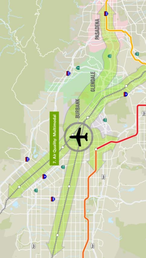
27 TRANSPORTATION IMPROVEMENTS Project Goal: Develop ground transportation improvements that will allow Bob Hope Airport to serve as a multimodal regional transportation hub. 27
28 TRANSPORTATION IMPROVEMENTS 1 2 Improve 3 Improve 4 Bring Coordinate 6 Better 7 Enhance Study Area Roadways Address Roadway Congestion Issues near Airport Burbank Glendale Pasadena Connection Regional Connections to Airport North Hollywood Connection Metro Rail/Busway Connections Consolidated Rail and Bus Connections Together Transit Lines for Easy Transfer Airport-Focused Transit Schedules Airport, Metro and Metrolink Hours of Operation and Frequency Airport Terminal Connectivity Connect Terminal to Other Uses in Area Bicycle/Pedestrian Infrastructure Multimodal Options to Reduce GHG emissions 28


29 1 Study Area Roadways LOS A B C D E F Underused road capacity Efficient use of road capacity Severely congested Intersection LOS Peak Hr 2010 Traffic 203 Predicted Traffic Key Corridors Serving Airport 29


30 Pasadena Glendale Bob Hope Airport On-demand SuperShuttle AIRPORT SHUTTLE EXPRESS BUS WITH ROAD IMPROVEMENTS Infrastructure improvements Median running light rail Space for luggage EXPRESS BUS Existing lanes for car traffic EXPRESS BUS OR low-boarding; interior space for luggage AT-GRADE LIGHT RAIL TRANSIT Light rail going below- grade BELOW-GRADE LIGHT RAIL TRANSIT 30


31 North Hollywood Bob Hope Airport Shared lanes Bus priority lanes MIXED TRAFFIC EXPRESS BUS MIXED TRAFFIC EXPRESS BUS Signal Priority SUPER SHUTTLE Existing free, ondemand van service HEAVY RAIL SUBWAY Fully dedicated right-of -way BUS-RAPID TRANSIT (DEDICATED RIGHT-OF-WAY) Dedicated lanes 31


32 4 Coordinate/Connect Transit Services Central transfer point for transit services Existing services converge in multiple locations Empire Ave pedestrian bridge Helpful signs at stations/stops REGIONAL INTERMODAL TRANSPORTATION CENTER, BURBANK BOB HOPE AIRPORT Maps and schedules of complementary services BURBANK BOB HOPE AIRPORT Real-time arrival info METRO EXPO STATION BURBANK METROLINK METRO EXPO STATION METRO EXPO STATION 32
33 METROLINK VENTURA COUNTY LINE / TRAK PACIFIC SURFLINER Existing Airport Service: Metrolink METROLINK ANTELOPE VALLEY LINE Flights/ Hour Flights/ Hour = Northbound trains per hour = Airport employee shift change = Northbound trains per hour = Airport employee shift change = Southbound trains per hour = Flights per hour = Southbound trains per hour = Flights per hour Each train symbol represents 1 train Ventura Line Trains include Amtrak operations serving BHA 33
34 Existing Airport Service: Metro Bus METRO BUS SERVICE NORTH/SOUTH METRO BUS SERVICE EAST/WEST Flights/ Hour Flights/ Hour = Northbound buses per hour = Airport employee shift change = Westbound buses per hour = Airport employee shift change = Southbound buses per hour = Flights per hour = Eastbound buses per hour = Flights per hour * Each bus symbol represents 2 buses. 34


 BELOW-GRADE REGIONAL")
35 6 Airport Terminal Connectivity luggage racks on shuttle Low, easy boarding Real-time arrival info METRO EXPO STATION AIRPORT CIRCULATOR BUS Frequent, easy connection between terminals Helpful signs at airport arrivals EXPO STATION Transit to Terminal Pedestrian Bridge Easy boarding with luggage AUTOMATED PEOPLE MOVER (A) BELOW-GRADE REGIONAL INTERMODAL TRANSPORTATION CENTER, BHA 3

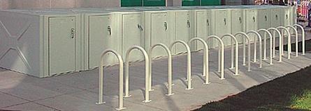
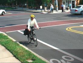
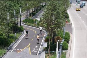
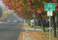


36 7 Improve Bike/Ped. Infrastructure First mile Transit trip Last mile Street-deck or parklet activates the street Secured bike parking for airport employees Directional curb cut Class 1 Bike Path Class 2 Bike Lane Class 3 Bike Route LONG BEACH, CA Bulb-out shields pedestrians/shortens crossing 36
37 MOVING FORWARD ALTERNATIVES NEAR-TERM LONG-TERM LOW-COST HIGH-COST Final Public Workshop: Wednesday, July 16 th, 2014, :30-7:30 City of Burbank Community Services Building 37
Develop ground transportation improvements to make the Airport a multi-modal regional
 Project Overview TRANSPORTATION IMPROVEMENTS WHAT ARE THE PROJECT GOALS? Transportation transportation hub. Develop ground transportation improvements to make the Airport a multi-modal regional Land Use
Service Quality: Higher Ridership: Very Affordable: Image:
 Over the past decade, much attention has been placed on the development of Bus Rapid Transit (BRT) systems. These systems provide rail-like service, but with buses, and are typically less expensive to
Executive Summary. Draft Environmental Impact Statement/Environmental Impact Report ES-1
 Executive Summary Introduction The Eastside Transit Corridor Phase 2 Project is a vital public transit infrastructure investment that would provide a transit connection to the existing Metro Gold Line
Sepulveda Pass Corridor Systems Planning Study Update
 Los Angeles County Metropolitan Transportation Authority Sepulveda Pass Corridor Systems Planning Study Update June 20, 2012 Measure R Transit Corridors One of 12 Measure R Transit Corridors approved by
REGIONAL TRANSPORTATION SETTING
 CIRCULATION ELEMENT WHITE PAPER NO. 1 REGIONAL TRANSPORTATION SETTING INTRODUCTION According to the Southern California Association of Governments (SCAG), by 2030 the six- County region will be home to
METRO Orange Line BRT American Boulevard Station Options
 METRO Orange Line BRT American Boulevard Station Options Bloomington City Council Work Session November 18, 2013 Christina Morrison BRT/Small Starts Project Office Coordinating Planning and Design AMERICAN
East San Fernando Valley Transit Corridor. TAC Briefing December 4, 2013
 East San Fernando Valley Transit Corridor TAC Briefing December 4, 2013 Overview Measure R Project Long Range Transportation Plan Reserves $170.1 Million 2018 Revenue Operations Date Coordination with
Community Open Houses November 29 December 7, 2017
 Community Open Houses November 29 December 7, 2017 1 Community Open House Agenda 6:00 PM Open House 6:30-7:30 PM Presentation and Q&A 7:30-8:00 PM Open House Resumes after the presentation and Q&A Thank
QUALITY OF LIFE EXECUTIVE SUMMARY REPORT I O N S TAT I O N
 QUALITY OF LIFE EXECUTIVE SUMMARY REPORT UN I O N S TAT I O N T R AV E L by TR A I N Published September 2017 2015 PROGRESS MAP This document reports FasTracks progress through 2015 BACKGROUND RTD The
A Transit Plan for the Future. Draft Network Plan
 A Transit Plan for the Future Draft Network Plan Project Overview and Status Completed Market Analysis and Service Evaluation. Developed Plan Framework and Guiding Principles. Developed a draft Five Year
Study Area, Related Projects and Travel Markets
 Study Area, Related Projects and Travel Markets Study area and related projects Travel between Valley and Westside North San Fernando Valley BRT (Alignment TBD) East San Fernando Valley Transit Corridor
6/6/2018. June 7, Item #1 CITIZENS PARTICIPATION
 June 7, 2018 Item #1 CITIZENS PARTICIPATION 1 Item #2 APPROVAL OF MINUTES Item #3 TRAC GOALS, FRAMEWORK & AGENDA REVIEW 2 COMMITTEE GOALS Learn about Southern Nevada s mobility challenges, new developments
DOWNTOWN CONCORD SPECIFIC PLAN
 Timeline Next Milestones Alternatives Analysis Draft Report to MTC - July 30 Draft Specific Plan Outline July 31 First Draft Specific Plan Report September 15 Schedule and Agendas July 22 nd DSC #5 Evaluation
IMPROVEMENT CONCEPTS
 IMPROVEMENT CONCEPTS for the South Novato Transit Hub Study Prepared by: January 11, 2010 DKS Associates With Wilbur Smith Associates IMPROVEMENT CONCEPTS Chapter 1: Introduction 1. INTRODUCTION The strategic
ATTACHMENT [B] PROJECT DESCRIPTION REQUESTED CITY OF LOS ANGELES ACTIONS
![ATTACHMENT [B] PROJECT DESCRIPTION REQUESTED CITY OF LOS ANGELES ACTIONS](/thumbs/72/67299149.jpg "ATTACHMENT [B] PROJECT DESCRIPTION REQUESTED CITY OF LOS ANGELES ACTIONS") ATTACHMENT [B] PROJECT DESCRIPTION REQUESTED CITY OF LOS ANGELES ACTIONS I. Project Location The Los Angeles International Airport (LAX) Landside Access Modernization Program ( Project ) comprises approximately
ATTACHMENT [B] PROJECT DESCRIPTION REQUESTED CITY OF LOS ANGELES ACTIONS I. Project Location The Los Angeles International Airport (LAX) Landside Access Modernization Program ( Project ) comprises approximately
Sherman Oaks Community Traffic Plan
 Sherman Oaks is a community that is geographically bound by the Santa Monica mountains on its southern boundary, and the ever-expanding San Fernando Valley on its western, northern, and eastern boundaries.
Preliminary Definition of Alternatives. 3.0 Preliminary Definition of Alternatives
 3.0 What preliminary alternatives are being evaluated? The alternatives for the East San Fernando Valley Transit Corridor project that were considered for screening include the No Build Alternative, Transportation
Sepulveda Pass Corridor Systems Planning Study
 Los Angeles County Metropolitan Transportation Authority Sepulveda Pass Corridor Systems Planning Study Streets and Freeways Subcommittee January 17, 2013 1 Sepulveda Pass Study Corridor Extends for 30
Chapter 4 : THEME 2. Transportation
 Chapter 4 : THEME 2 Strengthen connections to keep the Central Area easy to reach and get around 55 Figure 4.2.1 Promote region-wide transit investments. Metra commuter rail provides service to the east,
Countdown to the Closure Extended 53-Hour Closure of I-405 Freeway Between U.S. 101 and I-10 Planned in Mid-July for Mulholland Bridge Demolition
 Countdown to the Closure Extended 3-Hour Closure of I-40 Freeway Between U.S. 0 and I-0 Planned in Mid-July for Mulholland Bridge Demolition Work Los Angeles, Calif. Plan Ahead, Avoid The Area, Or Stay
West Santa Ana Branch Transit Corridor. Informational Briefing Gateway Cities Service Council April 13, 2017
 West Santa Ana Branch Transit Corridor Informational Briefing Gateway Cities Service Council April 13, 2017 Project Study Area 98 square miles 20 individual cities plus unincorporated LA County 1.2 million
Passenger rail service is returning to Greenfield!
 Passenger rail service is returning to Greenfield! How do we take advantage of this opportunity to boost our economy? Greenfield s train station circa 1920 Greenfield s train stop in 2014 Current Passenger
Community Meetings June 2018
 Community Meetings June 2018 1 Welcome and Agenda Thank you for joining us! 6:00 pm Open House 6:30 pm Welcome & Presentation 7:00 pm Q&A 7:15 pm Open House Resumes 8:00 pm Meeting Concludes 2 Purpose
Welcome and Agenda. Thank you for joining us! 6:00 pm Open House. 6:30 pm Welcome & Presentation. 7:00 pm Q&A. 7:15 pm Open House Resumes
 1 Welcome and Agenda Thank you for joining us! 6:00 pm Open House 6:30 pm Welcome & Presentation 7:00 pm Q&A 7:15 pm Open House Resumes 8:00 pm Meeting Concludes 2 Purpose of this Meeting Introduce project
Why coordinate the Van Nuys and Sepulveda Pass project studies together?
 Southern California's Leading Transit Advocacy Group P.O. Box 567 * San Fernando, CA 91341-0567 Voice: 818.362.7997 * Fax: 818.364.2508 www.transitcoalition.org The Transit Coalition (a project of LACBC)
4.1 Land Use. SECTION CONTENTS Land Use Transit Transportation Technology
 4 FUTURE CHANGES IN THE CORRIDOR Over the next 30 years, Santa Clara County will grow by roughly 637,000 residents and 303,500 jobs increases of 31 percent and 43 percent, respectively. 1 Changes in land
Newmarket GO Station Mobility Hub Study. Open House #1 MAY 18, 2017
 Newmarket GO Station Mobility Hub Study Open House #1 Naren Garg Metrolinx Advisor, RER Project Planning Amy Shepherd IBI Group Associate, Manager, Planning INTRODUCTIONS - METROLINX Metrolinx is an agency
King County Metro. Columbia Street Transit Priority Improvements Alternative Analysis. Downtown Southend Transit Study. May 2014.
 King County Metro Columbia Street Transit Priority Improvements Alternative Analysis Downtown Southend Transit Study May 2014 Parametrix Table of Contents Introduction... 1 Methodology... 1 Study Area...
2.0 Development Driveways. Movin Out June 2017
 Movin Out June 2017 1.0 Introduction The proposed Movin Out development is a mixed use development in the northeast quadrant of the intersection of West Broadway and Fayette Avenue in the City of Madison.
TRANSPORTATION REVIEW
 TRANSPORTATION REVIEW - PROPOSED MIX OF LAND USES IS CONSISTENT WITH THE CITY S UNDER THE GRANVILLE BRIDGE POLICIES THAT AIM TO MEET NEIGHBOURING RESIDENTS SHOPPING NEEDS AND REDUCE RELIANCE ON AUTOMOBILE
Troost Corridor Transit Study
 Troost Corridor Transit Study May 23, 2007 Kansas City Area Transportation Authority Agenda Welcome Troost Corridor Planning Study Public participation What is MAX? Survey of Troost Riders Proposed Transit
Landside Access Modernization Program (LAMP)
") Landside Access Modernization Program (LAMP) LAX Los Angeles International Airport is the 2 nd busiest airport in the United States and is the largest airport in California. Since the start of the economic
Landside Access Modernization Program (LAMP) LAX Los Angeles International Airport is the 2 nd busiest airport in the United States and is the largest airport in California. Since the start of the economic
Project Scoping Report Appendix B Project Web Site. APPENDIX B Project Web Site
 Project Scoping Report Appendix B Project Web Site APPENDIX B Project Web Site WESTSIDE EXTENSION TRANSIT CORRIDOR STUDY February 4, 2008 News and Info of 1 http://metro.net/projects_programs/westside/news_info.htm#topofpage
SUBREGIONAL MOBILITY MATRIX SAN FERNANDO VALLEY Project No. PS YY0101. Executive Summary
 SUBREGIONAL MOBILITY MATRIX SAN FERNANDO VALLEY Project No. PS40103041YY0101 Prepared for: Prepared by: STV Incorporated 1055 West Seventh Street Suite 3150 Los Angeles, CA 90017 1.0 EXECUTIVE SUMMARY
What is the Connector?
 What is the Connector? The Connector is a plan for a high-capacity transit system from northeast to south Ann Arbor, connecting major destinations including downtown, commercial, and residential areas,
This letter provides SPUR s comments on the Draft Supplemental Environmental Impact Statement/ Subsequent Environmental Impact Report.
 Tom Fitzwater, Environmental Planning Manager VTA Environmental Programs & Resources Management 3331 North First Street, Building B-2 San Jose, CA 95134 March 6, 2017 Submitted Electronically Re: VTA s
Green Line Long-Term Investments
 Enhancements Short-term improvements to keep Austin moving. Investments Long-term projects to support our future. Mobility Hubs MetroRapid MetroRail MetroExpress Connectors Circulators Project Connect
Overview: Division of Rail & Mass Transportation
 Page 2 Overview: Division of Rail & Mass Transportation Mass Transit Funding Programs Federal Transit Grants & Procurement State Transit Programs Cap & Trade Funding Passenger Rail Program Rail Planning
Bus Rapid Transit. Jennifer Flynn and Cheryl Thole Senior Research Associates Commuter Choice Workshop January 2012 Tampa, FL
 Bus Rapid Transit Jennifer Flynn and Cheryl Thole Senior Research Associates Commuter Choice Workshop January 2012 Tampa, FL What is Bus Rapid Transit? BRT is an enhanced bus system that operates on bus
Mobility Corridor Updates. Transit & Active Transportation Projects
 Mobility Corridor Updates Transit & Active Transportation Projects Manjeet Ranu, SEO East San Fernando Valley Transit Corridor Metro Board LPA selection: June 2018 Recently awarded $200 million in Senate
PAPER FOR AREMA 2006 ANNUAL CONFERENCE LOS ANGELES UNION STATION RUN-THROUGH TRACKS UNION STATION TERMINAL IMPROVEMENTS. Paul Mak, PE, SE HDR Inc
 PAPER FOR AREMA 2006 ANNUAL CONFERENCE LOS ANGELES UNION STATION RUN-THROUGH TRACKS UNION STATION TERMINAL IMPROVEMENTS Paul Mak, PE, SE HDR Inc 801 S. Grand Ave. Suite 500, Los Angeles, CA 90017. Tel
Community Meetings Welcome
 Community Meetings Welcome Thank you for joining us! Community Meetings Agenda 6pm Open House 6:30pm Welcome & Presentation 7pm Q&A 7:15pm Open House Resumes 8pm Meeting Concludes Community Meetings Agenda
IV. ENVIRONMENTAL IMPACT ANALYSIS N. TRANSPORTATION AND TRAFFIC
 IV. ENVIRONMENTAL IMPACT ANALYSIS N. TRANSPORTATION AND TRAFFIC The following section summarizes the information provided in the traffic report entitled Traffic Impact Analysis for a Proposed Residential
3. PRELIMINARY DEFINITION OF ALTERNATIVES
 3. PRELIMINARY DEFINITION OF ALTERNATIVES The purpose of the Preliminary Definition of Alternatives is to introduce the alternatives, including modes and off- and on-airport routes that will be carried
Metra Milwaukee District West Line Transit-Friendly Development Plan
 Metra Milwaukee District West Line Transit-Friendly Development Plan Community Input Workshop April 6, 2011 Overview of Presentation Workshop Goals Study Context Existing Conditions Market Overview Employment
Valley Metro Overview. ITE/IMSA Spring Conference March 6, 2014
 Valley Metro Overview ITE/IMSA Spring Conference March 6, 2014 Valley Metro Who Are We? Operate Regional Transit Services Valley Metro and Phoenix are region s primary service providers Light Rail and
Otay Ranch Station 2020 MOBILITY SERVICES MAP REGIONAL MOBILITY HUB IMPLEMENTATION STRATEGY
 MAGDALENA REGIONAL MOBILITY HUB IMPLEMENTATION STRATEGY Otay Ranch Station Mobility hubs are transportation centers located in smart growth areas served by high frequency transit service. They provide
San Rafael Civic Center Station Area Plan May 2012 DRAFT FOR PUBLIC REVIEW
 CHAPTER 4. PARKING Parking has been identified as a key concern among neighbors and employers in the area, both in terms of increased demand from potential new development and from SMART passengers that
DOWNTOWN CONCORD SPECIFIC PLAN
 Timeline 21-month process Tasks 1-3; Basis for the preparation of the plan (Jan. through March) Tasks 4-5; Development and Evaluation of Alternatives. Selection of Preferred Alternative. Preparation of
Public Meeting. City of Chicago Department of Transportation & Department of Housing and Economic Development
 Public Meeting City of Chicago Department of Transportation & Department of Housing and Economic Development Funded by Regional Transportation Authority September 12, 2011 In partnership with Presentation
Executive Summary. Treasure Valley High Capacity Transit Study Priority Corridor Phase 1 Alternatives Analysis October 13, 2009.
 Treasure Valley High Capacity Transit Study Priority Corridor Phase 1 Alternatives Analysis October 13, 2009 Background As the Treasure Valley continues to grow, high-quality transportation connections
Conceptual renderings subject to change
 Conceptual renderings subject to change OCTA Special Needs Committee Presentation Tuesday, Project Presenter Jamie Lai, P.E. Transit Manager, City of Anaheim The ARTIC Project Manager 2 The ARTIC Project
Measure R Funded Transit Projects
 Measure R Funded ransit Projects Crenshaw/LAX ransit Corridor New Potential LAWA erminal & Ground Access Facilities ypes of Connections Direct Light Rail ransit (LR) Branch Metro goes to the airport Metro
6/11/2018. June 7, Item #1 CITIZENS PARTICIPATION
 June 7, 2018 Item #1 CITIZENS PARTICIPATION 1 Item #2 APPROVAL OF MINUTES Item #3 TRAC GOALS, FRAMEWORK & AGENDA REVIEW 2 COMMITTEE GOALS Learn about Southern Nevada s mobility challenges, new developments
Transit and Job Growth: Lessons for SB 375. Jed Kolko Public Policy Institute of California
 Transit and Job Growth: Lessons for SB 375 Jed Kolko Public Policy Institute of California Outline Approaches to reducing VMT The land use transportation connection California s experience with transit-oriented
Mobility Corridor Updates. Transit & Active Transportation Projects
 Mobility Corridor Updates Transit & Active Transportation Projects Laura Cornejo, DEO Regional Planner Regional Operator Metro is LA County s Regional Builder/Funder Rail Bus Service (Metro/Muni/Local)
Central Loop Bus Rapid Transit
 Central Loop Bus Rapid Transit Transportation Goals of the Chicago Central Area ACTION Plan, page 2-6 Central Area Plan Improve Transit in Central Area Improve Pedestrian Environment Manage Traffic Circulation
Pedestrians, Cars, Buses and Trains? Considerations for Rapid Transit Service at Western University
 Pedestrians, Cars, Buses and Trains? Considerations for Rapid Transit Service at Western University Shift: The City of London s Rapid Transit Proposal Shift: The City of London s Rapid Transit Proposal
David Martin, Director of Planning and Community Development. Establishment of LAX FlyAway Stop in Santa Monica
 Information Item Date: January 31, 2014 To: From: Subject: Mayor and City Council David Martin, Director of Planning and Community Development Establishment of LAX FlyAway Stop in Santa Monica Introduction
A report on unmet San Fernando Valley. Wednesday, January 2, 2013
 A report on unmet San Fernando Valley Transportation Needs Wednesday, January 2, 2013 About The Transportation Tiger Team The team consists of CSUN Urban Planning students concerned about public transportation
TRAFFIC IMPACT STUDY. USD #497 Warehouse and Bus Site
 TRAFFIC IMPACT STUDY for USD #497 Warehouse and Bus Site Prepared by: Jason Hoskinson, PE, PTOE BG Project No. 16-12L July 8, 216 145 Wakarusa Drive Lawrence, Kansas 6649 T: 785.749.4474 F: 785.749.734
Bi-County Transitway/ Bethesda Station Access Demand Analysis
 Bi-County Transitway/ Bethesda Station Access Demand Analysis Prepared for: Washington Metropolitan Area Transit Authority Office of Planning and Project Development May 2005 Prepared by: in conjunction
LOS ANGELES COUNTY METROPOLITAN TRANSPORTATION AUTHORITY (LACMTA) AND FEDERAL TRANSIT ADMINISTRATION (FTA)
 AND FEDERAL TRANSIT ADMINISTRATION (FTA)") LOS ANGELES COUNTY METROPOLITAN TRANSPORTATION AUTHORITY (LACMTA) AND FEDERAL TRANSIT ADMINISTRATION (FTA) NOTICE OF PREPARATION (NOP)/NOTICE OF INTENT (NOI) OF AN ENVIRONMENTAL IMPACT STATEMENT (EIS)/ENVIRONMENTAL
LOS ANGELES COUNTY METROPOLITAN TRANSPORTATION AUTHORITY (LACMTA) AND FEDERAL TRANSIT ADMINISTRATION (FTA) NOTICE OF PREPARATION (NOP)/NOTICE OF INTENT (NOI) OF AN ENVIRONMENTAL IMPACT STATEMENT (EIS)/ENVIRONMENTAL
Midtown Corridor Alternatives Analysis Key Issues Memo
 Midtown Corridor Alternatives Analysis Key Issues Memo 1/4/2013 Prepared by the SRF Consulting Group Team for Table of Contents Introduction... 1 1. Markets... 1 External Markets... 1 Intra-Corridor Travel...
Restoration of Historic Streetcar Services in Downtown Los Angeles
 Restoration of Historic Streetcar Services in Downtown Los Angeles Alternatives Analysis Community Update Meeting August 2, 2011 Introduction Key players Local lead agency: Metro Federal lead agency: Federal
Status of Plans March Presented by CAPITOL REGION COUNCIL OF GOVERNMENTS
 Status of Plans March 2011 Presented by CAPITOL REGION COUNCIL OF GOVERNMENTS Transit project update Project rationale The system New Britain Hartford Busway New Haven/Hartford/ Springfield Passenger Rail
The Engineering Department recommends Council receive this report for information.
 CORPORATE REPORT NO: R161 COUNCIL DATE: July 23, 2018 REGULAR COUNCIL TO: Mayor & Council DATE: July 19, 2018 FROM: General Manager, Engineering FILE: 8740-01 SUBJECT: Surrey Long-Range Rapid Transit Vision
BROWARD BOULEVARD CORRIDOR TRANSIT STUDY
 BROWARD BOULEVARD CORRIDOR TRANSIT STUDY FM # 42802411201 EXECUTIVE SUMMARY July 2012 GOBROWARD Broward Boulevard Corridor Transit Study FM # 42802411201 Executive Summary Prepared For: Ms. Khalilah Ffrench,
Metro Green Line to LAX Alternatives Analysis. March 2012
 Metro Green Line to LAX Alternatives Analysis 1 2 The Crenshaw/LAX Project Foundation for Metro Green Line to LAX 8.5 mile extension Metro Exposition Line (Crenshaw Exposition) to Metro Green Line (Aviation/LAX
Waco Rapid Transit Corridor (RTC) Feasibility Study
 Feasibility Study") Waco Rapid Transit Corridor (RTC) Feasibility Study Chris Evilia, Director of Waco Metropolitan Planning Organization Allen Hunter, General Manager Waco Transit System Jimi Mitchell, Project Manager AECOM
Waco Rapid Transit Corridor (RTC) Feasibility Study Chris Evilia, Director of Waco Metropolitan Planning Organization Allen Hunter, General Manager Waco Transit System Jimi Mitchell, Project Manager AECOM
Kendall Drive Premium Transit PD&E Study Project Kick-Off Meeting SR 94/Kendall Drive/SW 88 Street Project Development and Environment (PD&E) Study
 Study") Florida Department of Transportation District Six Kendall Drive Premium Transit PD&E Study Project Kick-Off Meeting SR 94/Kendall Drive/SW 88 Street Project Development and Environment (PD&E) Study What
Florida Department of Transportation District Six Kendall Drive Premium Transit PD&E Study Project Kick-Off Meeting SR 94/Kendall Drive/SW 88 Street Project Development and Environment (PD&E) Study What
DEVELOPMENT OF RIDERSHIP FORECASTS FOR THE SAN BERNARDINO INFRASTRUCTURE IMPROVEMENT STUDY
 APPENDIX 1 DEVELOPMENT OF RIDERSHIP FORECASTS FOR THE SAN BERNARDINO INFRASTRUCTURE IMPROVEMENT STUDY INTRODUCTION: This Appendix presents a general description of the analysis method used in forecasting
Revised Evaluation Scores. System Preservation
 Revised Evaluation s System Preservation This page provides a summary of any revisions made to the draft scores presented at the October th Attributable Funds mmittee meeting. The information below highlights
Location Concept Plan Amendment Recommendation Approved 2011 Concept Plan
 Valley Line West LRT Concept Plan Recommended Amendments Lewis Farms LRT Terminus Site Location Concept Plan Amendment Recommendation Approved 2011 Concept Plan Lewis Farms LRT terminus site, 87 Avenue/West
4 Circulation & Transportation
 4.1 Mobility Network The mobility network at the new St. Paul s hospital and health campus is comprised of an interconnected system of sidewalks, cycle paths, transit routes and roadways. Figure 4-1: Indicative
PAPER FOR AREMA 2004 ANNUAL CONFERENCE LOS ANGELES UNION STATION RUN-THROUGH TRACKS. Paul Mak, PE, SE - DMJM HARRIS
 1 PAPER FOR AREMA 2004 ANNUAL CONFERENCE LOS ANGELES UNION STATION RUN-THROUGH TRACKS Paul Mak, PE, SE - DMJM HARRIS 515 S. Flower Street 9th Floor, Los Angeles, CA 90071. Tel 213-593-8337 Fax 213-593-8622
1 Downtown LRT Connector: Draft Concept
 Downtown LRT Connector: Draft Concept Plan November 2010 We re moving forward. Get involved. On June 21, 2010, City Council approved a street-level downtown LRT route, including a connector for the future
BRT: What is it & Where Does it Fit? Sam Zimmerman
 BRT: What is it & Where Does it Fit? Sam Zimmerman 1 BRT: Bus Rapid Transit Flexible, permanently integrated, high performance system with a quality image and a strong ID Package of components appropriate
Public Meeting. June 15, :30 7:30 p.m.
 Public Meeting June 15, 2017 5:30 7:30 p.m. Welcome 2015 Naval Station Norfolk Transit Extension Study 2015 Naval Station Norfolk Transit Extension Study 2017 Norfolk Westside Transit Study HRT and the
Fresno Yosemite International Airport to 2233 Ventura St, Fresno, CA Google Maps
 Fresno Yosemite International Airport to 2233 Ventura St, Fresno, CA 93721 - Google Maps http://maps.google.com/maps?f=d&source=s_d&saddr=fresno+air+terminal,+east+clinton+way,+fresno... Page 2 of 2 Fresno
Maryland Gets to Work
 I-695/Leeds Avenue Interchange Reconstruction Baltimore County Reconstruction of the I-695/Leeds Avenue interchange including replacing the I-695 Inner Loop bridges over Benson Avenue, Amtrak s Northeast
APPENDIX I: [FIXED-GUIDEWAY TRANSIT FEASIBILITY]
![APPENDIX I: [FIXED-GUIDEWAY TRANSIT FEASIBILITY]](/thumbs/83/87090921.jpg "APPENDIX I: [FIXED-GUIDEWAY TRANSIT FEASIBILITY]") APPENDIX I: [FIXED-GUIDEWAY TRANSIT FEASIBILITY] Jackson/Teton Integrated Transportation Plan 2015 Appendix I. Fixed-Guideway Transit Feasibility Jackson/Teton County Integrated Transportation Plan v2
APPENDIX I: [FIXED-GUIDEWAY TRANSIT FEASIBILITY] Jackson/Teton Integrated Transportation Plan 2015 Appendix I. Fixed-Guideway Transit Feasibility Jackson/Teton County Integrated Transportation Plan v2
EUGENE-SPRINGFIELD, OREGON EAST WEST PILOT BRT LANE TRANSIT DISTRICT
 EUGENE-SPRINGFIELD, OREGON EAST WEST PILOT BRT LANE TRANSIT DISTRICT (BRIEF) Table of Contents EUGENE-SPRINGFIELD, OREGON (USA)... 1 COUNTY CONTEXT AND SYSTEM DESCRIPTION... 1 SYSTEM OVERVIEW... 1 PLANNING
Click to edit Master title style
 Nelson/Nygaard Consulting Associates SERVICE IMPROVEMENT STRATEGIES September 22, 2015 1 PROJECT OVERVIEW & WORK TO DATE 1. Extensive stakeholder involvement Throughout 2. System and market assessment
Rail alignment and benefits (rab) study
 study") Rail alignment and benefits (rab) study previously known as railyard alternatives & i-280 boulevard study June 5, 2018 CONNECTING CALIFORNIA 4,300 lane miles + 115 Airport gates would be needed to create
Rail alignment and benefits (rab) study previously known as railyard alternatives & i-280 boulevard study June 5, 2018 CONNECTING CALIFORNIA 4,300 lane miles + 115 Airport gates would be needed to create
We Want Your Input! Review the design alternatives and tell us what s important to you in the design of these areas of the approved BRT Network:
 We Want Your Input! Review the design alternatives and tell us what s important to you in the design of these areas of the approved BRT Network: Richmond North of Oxford Street Richmond Row Dundas Street
vision42
 vision42 www.vision42.org vision42 auto-free light rail boulevard for 42nd Street Roxanne Warren, AIA, Chair George Haikalis, ASCE, Co-Chair Institute for Rational Urban Mobility,Inc. www.vision42.org
Introducing the Solution to LA s Airport Congestion Problem
 Presentation by Roger J. Rudick Introducing the solution to the County s airport congestion problem Introducing the Solution to LA s Airport Congestion Problem Existing infrastructure, off-the-shelf technology,
Rail~Volution 2005 Hal Ryan Johnson, AICP, Bus Rapid Transit Project Manager Utah Transit Authority September 7, 2005
 Rail~Volution 2005 Hal Ryan Johnson, AICP, Bus Rapid Transit Project Manager Utah Transit Authority September 7, 2005 Public Transit District Utah Transit Authority Linear Geographic Area - 130 miles by
The Latest on Joint Development Policy Guidance
 Panelists The Latest on Joint Development Policy Guidance Moderator: Jonathan Davis Deputy General Manager and Chief Financial Officer Massachusetts Bay Transportation Authority James Blakesley, Attorney-Advisor,
Rail~Volution 2012 R. Gregg Albright
 CALIFORNIA HIGH-SPEED RAIL AUTHORITY October 16 th, 2012 Rail~Volution 2012 R. Gregg Albright WHAT IS CALIFORNIA HIGH-SPEED TRAIN PROJECT (CHSTP) and HOW WILL IT BE IMPLEMENTED? 2 CALIFORNIA HIGH SPEED
East San Fernando Valley Transit Corridor. Information Session, October 10, 2017
 East San Fernando Valley Transit Corridor Information Session, October 10, 2017 1 Welcome and Meeting Purpose Introductions Metro Transit Corridors Planning Metro Real Estate Metro Community Relations
Metro. Board Report. B. PROGRAM AND AMEND the FY 17 budget to add $900,000 in Measure R Commuter Rail service funds to conduct this study; and
 Metro Board Report Los Angeles County Metropolitan Transportation Authority One Gateway Plaza 3rd Floor Board Room Los Angeles, CA File #:2016-0284, File Type:Motion / Motion Agenda Number:9. REVISED PLANNING
Kenosha-Racine-Milwaukee (KRM)
") Kenosha-Racine-Milwaukee (KRM) Commuter Rail #147925 November 6, 2009 1 Guidance of KRM Commuter Rail Studies Intergovernmental Partnership Technical Steering Committee Temporary and Limited Authority
Kenosha-Racine-Milwaukee (KRM) Commuter Rail #147925 November 6, 2009 1 Guidance of KRM Commuter Rail Studies Intergovernmental Partnership Technical Steering Committee Temporary and Limited Authority
Hennepin County Transit Oriented Development Program. The Ellipse, St. Louis Park, 2009
 Hennepin County Transit Oriented Development Program The Ellipse, St. Louis Park, 2009 What is Transit Oriented Development (TOD)? Development within walking distance of transit Typically ¼ to ½ mile 10
Rail alignment and benefits (rab) study
 study") Rail alignment and benefits (rab) study previously known as railyard alternatives & i-280 boulevard study May 22, 2018 CONNECTING CALIFORNIA 4,300 lane miles + 115 Airport gates would be needed to create
Rail alignment and benefits (rab) study previously known as railyard alternatives & i-280 boulevard study May 22, 2018 CONNECTING CALIFORNIA 4,300 lane miles + 115 Airport gates would be needed to create
2/1/2018. February 1, Item #1 CITIZENS PARTICIPATION
 February 1, 2018 Item #1 CITIZENS PARTICIPATION 1 Item #2 APPROVAL OF MINUTES Item #3 TRAC GOALS, FRAMEWORK & AGENDA REVIEW 2 COMMITTEE GOALS Learn about Southern Nevada s mobility challenges, new developments
SUPPORTING TOD IN METRO CHICAGO
 www.rtachicago.org SUPPORTING TOD IN METRO CHICAGO Tuesdays at APA November 18, 2014 OVERVIEW OF RTA 2 11/18/2014 Tuesdays at APA: Supporting TOD in Metro Chicago RTA Region 8.5 million people 3,700 square
THE FUTURE OF VANCOUVER S VIADUCTS
 THE FUTUE OF VANCOUVE S VIADUCTS Welcome to our information session on the future of Vancouver s viaducts. Over the past two years City staff have been testing the replacement of the Georgia and Dunsmuir
Pomona Rotary December 19, 2017
 Pomona Rotary December 19, 2017 Los Angeles County s population will grow by 5.9% to 10.7 million by 2024 During that same period, the San Gabriel Valley will grow by 7.6% to more than 1.5 million; taking