Appendix E Written Comments
|
|
|
- Lizbeth Robbins
- 5 years ago
- Views:
Transcription
1 Appendix E Written Comments
2 Appendix E - Contents Agency Written Comments Public Written Comments
3 Agency Written Comments
4 Nancy Stavish/Minneapolis/URSCorp 09/01/ :13 PM To cc bcc Subject Fw: ER-10/ Cotton Belt Corridor -- no comments "John Hoppie" 08/30/ :43 AM Subject To "Judson Meshack" cc Fwd: ER-10/ Cotton Belt Corridor -- no comments >>> 8/30/ :30 AM >>> The National Park Service has reviewed this project, and determined that no parks will be affected; therefore, we have no comments. Thank you! Julie ~~~~~~~~~~~~~~~~~~~~~~~~~~~~~ Julie Sharp Planning Tech/Environmental Protection Assistant National Park Service - Intermountain Regional Office Denver, CO ph
5

6
7


8
9 Public Written Comments


10


11
12

13


14


15


16


17


18

19


20

21

22

23


24


25

26
27

28


29


30


31

32

33

34


35


36


37

38


39


40

41


42

43


44

45


46
47
48
49
50
51
52
53
54
55
56
57
58
59
60
61
62
63
64
65
66
67
68
69
70
71
72
73
74
75
76
77
78
79
80
81
82
83
84
85
86
87
88
89
90
91
92
93
94
95
96
97
98
99
100
101
102
103
104
105
106
107
108
109
110
111
112
113
114
115
116
117
118
119
120
121

122


123


124
125

126
127
128
129


130
131
132
133
134
135
136
137
138
139
140

141
142
143
144
145
146
147
148
149

150
151
152

153
154
155
156
157
158


159
160
161
162
163
164

165
166


167
168
169
170


171
172
173

174
175
176
177
178


179
180
181
182
183
184
185
186
187
188

189
190
191
192
193
194


195


196
197
198
199
200
201
202
203
204
205
206
207
208
209
210
211
212

213
214
215
216
217
218

219
220
221


222
223
224
225
226
227
228
229
230


231
232
233
234

235
236
237
238
239
240
241
242
243
244
245
246
247
248
249
250
251

252
253
254
255
256
257

258
259
260
261
262
263

264
265
266
267
268
269
270
271
272

273
274
275
276
277
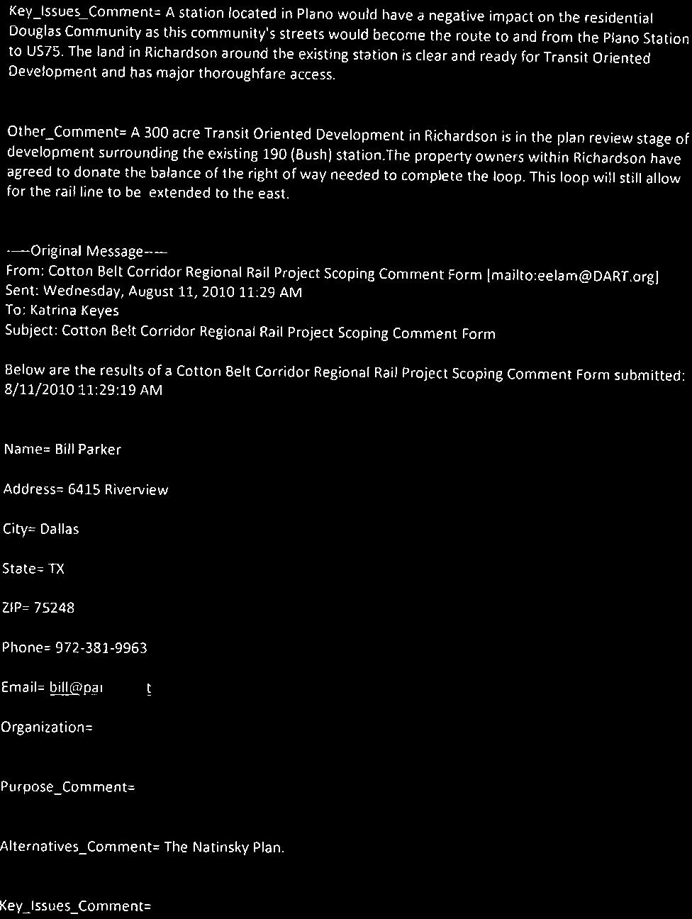
278 DART Cottonbelt Scoping Comments August 30, It is imperative that Addison have a rail station within the city limits to build on Addison s long term commitment to DART and Transit Oriented Development within the Addison Circle Development. The bus transit station was built and the documents reference a future rail station. 2. The cost of construction should not be excessive for construction of a new rail line. 3. Consider quiet zoning the corridor where warranted to mitigate impacts to residential neighborhoods. Nancy Straub Cline, P.E. Director of Public Works Town of Addison (972)
279


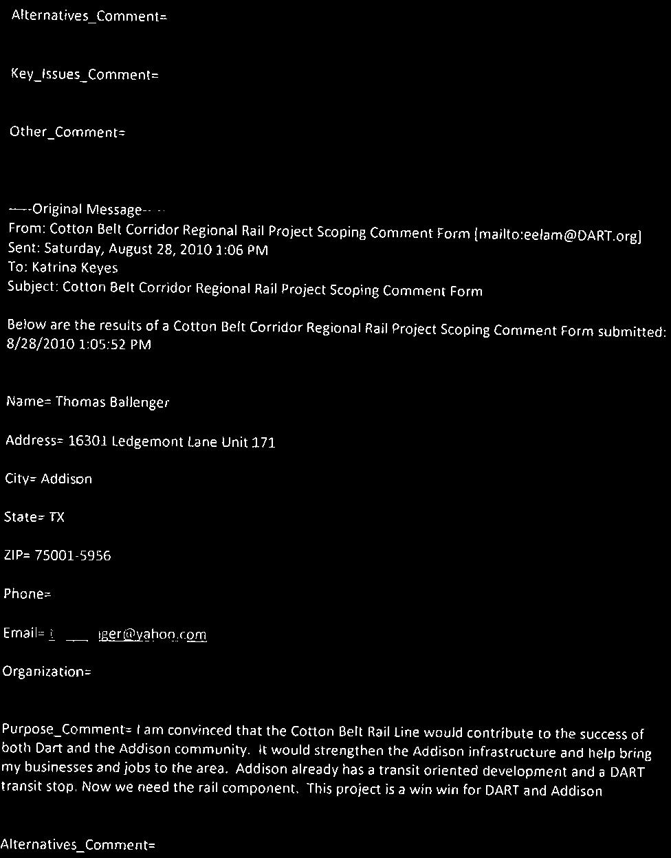
280


281


282
283 YOUR IMMEDIATE ACTION IS NEEDED!!! Urge DART to incorporate the elements of the Natinsky Plan into the Cotton Belt rail line. Deadline for public imput is August 30, 2010 N A T I N S K Y COTTON BELT It is critical that each of you John Hoppie at jhoppie@dart.org and urge DART to incorporate all elements of the Natinsky Plan into the financing and implementation of the Cotton Belt line. On Thursday, July 29 DART unveiled a possible new timetable for the project. They requested input from the public, and that is you. The public comment period ends August 30, This is the last time public comments will be taken during what is known as the scoping period. Many residents worked for years to design safeguards to help protect the neighborhood. Those safeguards were incorporated into the Natinsky Plan. DART today and let them know the Natinsky Plan must be followed. As DART s website on the Cotton Belt ( provides: Your input, whether oral or written, will help shape your community s quality of life. Those of you who have lived in the neighborhood prior to 2006 know the efforts it took to reach a compromise on the implementation of the Cotton Belt rail line. For those of you newer to the neighborhood, or for an update on the issue, please see below. The Cotton Belt Corridor is a 26-mile rail line right of way owned by DART which extends from the DFW Airport to Central Expressway. Rail service along the line is proposed for the system s 2030 transit plan. However, DART is exploring new funding that could make implementation of the line possible in the next several years. In and near our neighborhood, the rail line crosses the following streets (from east to west): Coit, Meandering Way, McCallum, Hillcrest, Davenport, Campbell, Davenport (again) and Preston. Trains would run every 20 minutes during peak hours, and every hour during non-peak hours. Prior to 2006, DART s plan was to put heavy commuter diesel trains on the line which would have co-existed with the freight train. The noise, vibration and pollution from such trains were totally unacceptable to the neighborhoods along the Cotton Belt. In 2006, Councilmember Natinsky proposed a plan (now known as the Natinsky Plan ) for responsible development. NATINSKY PLAN Light rail technology A below grade trench from at least 1500 feet east of Meandering Way to 2000 feet west of Preston Road Elimination of freight trains Specified neighborhood stations Enhanced landscaping and sound attenuation Integration with the hike and bike system. The Natinsky Plan was incorporated into a Dallas City Council Resolution passed in June Several elements of the Natinsky Plan have already been achieved. The freight is off the tracks in the residential corridor of the Cotton Belt this is a milestone. Second, new technology in rail vehicles makes it possible for the trains to be self propelled with engines running as quietly as light rail and with emission levels consistent with light rail technology, but without the overhead wires. For more specific information on the process of implementing rail along the Cotton Belt, you may go to DART s website: Please support the Natinsky Plan while you re there.
284 Nancy Stavish/Minneapolis/URSCorp 11/16/ :56 PM To cc bcc Subject Fw: Cotton Belt Eastern Terminus From: "John Hoppie" Sent: 07/13/ :39 AM EST To: Dan Meyers; Megan Inman Subject: Fwd: Cotton Belt Eastern Terminus >>> Steve Salin 7/13/2010 8:06 AM >>> >>> "Frank Turner" 7/12/2010 4:13 PM >>> Attached is a preliminary report prepared by the City of Plano staff on the eastern temporary terminus of the Cotton Belt Line. It relies primarily on the findings of NCTCOG s study of the Cotton Belt Line and an analysis of the potential for a 12 th Street Station in Plano prepared by Parsons. We understand that DART is actively engaged in preparing preliminary engineering plans and environmental studies essential to the next level of decision making. Nevertheless, we believe the proposed 12 th Street Station offers many advantages to the overall design of the system. We hope this report will benefit DART s efforts in considering various alternatives. We look forward to working together on this and many other projects to improve regional mobility. Frank F. Turner, FAICP Deputy City Manager Phone: (972) Frankt@plano.gov
285

286 Cotton Belt Corridor Study and Eastern Terminus Alternatives July 1, 2010 Overview DART owns 54 miles of the Cotton Belt Corridor from Fort Worth to Wylie. The majority of the rail line is used for freight movement by commercial operators. This east-west corridor has been on the regional mobility plan for many years for future commuter rail service. The Fort Worth Transportation Authority (the T) is currently preparing plans to develop the western half of the corridor to provide passenger service from Ft. Worth to D/FW International Airport (D/FW). The North Central Texas Council of Governments (NCTCOG) recently completed a study of the eastern half of the corridor to examine its potential for passenger service from D/FW to a junction with the DART Light Rail Transit (LRT) Red Line in either Plano or Richardson. In a future phase, Cotton Belt passenger service could be extended to Wylie. The NCTCOG Cotton Belt study identifies issues, conceptual alternative alignments and stations, and it estimates ridership and capital development costs for each alternative. This information is currently being used by DART for the preparation of preliminary engineering plans, environmental studies and implementation strategies. A summary of certain key points from the study are discussed below. Of particular concern are alternative locations for the temporary eastern terminus of the Cotton Belt Line. Cotton Belt Corridor 1
 for their crash worthiness should they collide with a freight train.")
287 Rail Technology While portions of the Cotton Belt Corridor have been abandoned for freight traffic, the majority of the corridor will remain in use for freight movement. Because of this, passenger vehicles used in the corridor must be reviewed by the Federal Railroad Administration (FRA) for their crash worthiness should they collide with a freight train. Passenger vehicles meeting the standards are certified as being FRA compliant. The T and DART are working together to obtain FRA approval of a self-propelled diesel-electric vehicle that is similar in appearance and performance to a light rail vehicle. The vehicle currently favored is similar to vehicles used by Capital Metro in Austin and the Denton County Transportation Authority (DCTA). The vehicle is slightly larger than DART LRT vehicles. The proposed vehicle can run as a single car or as a two to four car train. NCTCOG calls the vehicle technology Light-Rail New Technology (LRNT). DART refers to it as Regional Rail. Light Rail Compatibility - Under existing federal regulations, the proposed LRNT vehicle cannot share tracks with a LRT vehicle because it is too heavy and sturdy. The junction of the Cotton Belt and Red Line will require aligning separate tracks and platforms so passengers can transfer from one mode to the other. Even if federal regulations were changed to permit a LRNT vehicle to share tracks with a LRT vehicle, the grade and curvature of existing DART tracks and the platform design specifications are not compatible with the LRNT car design. Passenger Capacity and Volumes - Each LRNT car can carry approximately 200 passengers (seated and standing). The current plan is for trains to stop at each station every 20 minutes during weekday peak hours and every 60 minutes during weekday off-peak hours. Weekend headways would range from 60 to 90 2
288 minutes. NCTCOG projects approximately 6,000 to 7,000 weekday passenger trips (each direction is a separate trip) by the year 2030 on the Cotton Belt s 22 mile eastern segment (D/FW to the DART Red Line.) By comparison, the DART Red Line from Mockingbird to Parker Road currently averages 14,000 weekday trips. Transit Oriented Development The Cotton Belt operating plan and projected ridership are not sufficient to produce successful urban mixed-use development. Assuming alternate station configurations (see below), the Cotton Belt study estimates in the year 2030 the weekday daily ridership at the proposed 12 th Street Station to be 450 people. Substituting the Bush Station as the temporary terminus, the Bush Station weekday daily ridership in the year 2030 is estimated to be 810 riders (current Bush ridership on the DART Red Line is 1,087). Less than 5% of the riders are estimated to begin or complete their trip on foot. Hopefully, these numbers underestimate the passenger demand, especially the number of people who walk to and from the stations. But even if the actual traffic were three or four times the estimates, Cotton Belt trips alone would be insufficient to create successful development. What drives successful urban mixed-use development? Most successful urban mixed-use projects have an exceptional location, proximity to employment, good accessibility, proximity to high volume regional arterials and excellent design. Addison Circle, Legacy Town Center, Southlake Town Square and the West Village are just a few examples of successful transitless urban mixed-use development. Successful transitoriented developments share the same location and design characteristics, and a well designed and integrated transit station complements the development and enhances its likelihood of success. Transit Ridership DART 2009 Cotton Belt 2030 Alternative Estimates Station Passengers Station Passengers #5 Passengers #6 Lovers Lane 1,151 DFW A/B Park Lane 1,923 Airport North Walnut Hill 1,125 North Lake Forest Lane 1,503 Carrollton 1,400 1,610 LBJ/Central 888 Addison Spring Valley 1,095 Knoll Trail X X Arapaho Center 1,124 Preston Road Galatyn Park 398 Renner Village X 710 Bush Turnpike 1,087 UTD/Synergy Downtown Plano 652 Bush 810 X Parker Road 2, th Street X 450 Total 13,915 5,600 5,800 3
289 Development Cost The NCTCOG study attempts to estimate the cost of various alternatives for developing the Cotton Belt from D/FW to its temporary eastern terminus. Each alternative adds and removes stations, and with the exception of two alternatives that include an extension to McKinney, all the alternatives range from $800 to $900 million. All of the estimates were based on typical costs and multipliers. No actual engineering studies were conducted of station locations, grade crossings or other site factors that will significantly affect costs. DART is currently preparing a preliminary engineering design to further understand alternatives and their costs. Long Term Expansion Plans The NCTCOG study does not assess the longterm plan to extend rail service to southeast Collin County. Job growth in Plano s Research/Technology District and residential development in Murphy, Wylie and Sachse are increasing the need for transit service. While DART owns the Cotton Belt corridor to Wylie, station locations have not been determined. Unless they are purchased soon, the best sites may not be available when the line is extended. Temporary Eastern Terminus Locations - The NCTCOG Cotton Belt study identifies two locations for the temporary eastern terminus the existing Bush Station and the new proposed 12 th Street Station. Both stations could serve as a transfer between the DART Red Line and the Cotton Belt. DART has begun preliminary engineering design and environmental studies that will be used to determine the final station locations, rail design elements and cost estimates. The Plano City Council has passed a resolution that supports the Cotton Belt Study and commits available resources to obtain and reserve land if the proposed 12 th Street Station is chosen. The City of Richardson passed a similar resolution supporting the Bush Station. Both the Bush and the 12 th Street Station have advantages and disadvantages that must be considered by DART in evaluating and finally deciding which location is chosen. The following discussion will identify and explain the advantages and disadvantages for each station location: 4

290 Temporary Eastern Terminus Options 12 Street Station - The proposed 12 th Street Station would be located along the existing Cotton Belt alignment immediately east of its intersection with the DART Red Line at the southwest corner of 12 th Street and Avenue K. No additional right-of-way would be required for the rail line or the station platform. The station would require two vertically separated platforms. The Cotton Belt Platform (green below) would be located at ground level on the south side of 12 th Street before its intersection with Avenue K. The DART LRT Redline Platform (red below) would be located on a reconstructed overpass crossing 12 th Street. The two platforms would be connected by stairs and elevator or escalator. Reconstruction of the existing overpass is likely needed to provide a long flat section for the passenger platform and to carry the additional weight of the platform. More study is needed to determine how the construction would be conducted. It may be possible to bypass the existing overpass or rely on a single track during phased construction of the new structure. It is also possible that DART Red Line service to the Downtown Plano and Parker Road Stations would need to be temporarily suspended. Approximately three to four acres would be needed on the north side of 12 th Street for 300 to 400 parking spaces. The Plano City Council has approved a resolution supporting the 12th Street Station and committing to acquire or protect land needed for parking. 5
 have already made major investments in the area.")
291 12 th Street Station The 12 th Street Station could further encourage redevelopment of property located south of 14 th Street. Property owners and developers (the Sheas, Holt- Lunsford Company) have already made major investments in the area. A 12 th Street Station would benefit the Douglass neighborhood by improving access to employment and services. Another benefit of the station is providing overnight storage of trains at the end of the line. DART could easily store trains east of the 12 th Street Station and Avenue K within the Cotton Belt right-of-way it owns. This would allow beginning daily service without costly and inefficient deadheading of trains. Bush Station The City of Richardson proposes using the Bush Station as the temporary eastern terminus to the Cotton Belt Line. Despite being located at the high volume intersection of US 75 and the President George Bush Turnpike, the existing Bush Station service the DART Red Line, the Bush Station only ranks 8 th in ridership of the 11 LRT stations north of the Mockingbird Station. This may be primarily because the station is surrounded by open fields and there are only a few jobs and no housing within walking distance. Richardson is working with area property owners to plan and develop a large scale mixed-use urban center connected to the transit center. However, the larger problem may be station parking and accessibility. The primary ridership shed served by this station lies to the north. Because of the design of the US 75/Bush interchange, it is hard for south and eastbound traffic on these facilities to access the station. In addition, DART parking for the Bush Station is located under the interchange between two service roads. Presuming the proposed development is successful, increased traffic on the service roads will make it even more difficult for commuters to walk between the platform and parking lot. 6

292 Cotton Belt Southern Connection to the Bush Station Cotton Belt US 75 Crossing - A critical factor in determining the best interim eastern terminus of the Cotton Belt Line is tied to the line s future crossing of US 75. Today, the Cotton Belt crosses US 75 immediately south of Plano Parkway. 7 Reconstructed Crossing - TxDOT is currently preparing plans to reconstruct the existing Cotton Belt crossing over US 75 as a part of a larger set of improvements to US 75/Bush interchange. TxDOT is coordinating the design with DART. TxDOT will construct the abutments and footings to support additional tracks for passenger service. DART will be responsible for adding the spans and tracks as needed. This crossing must be rebuilt for existing and future freight service. TXDOT s work will make it cheaper and quicker for DART to modify the crossing for transit service than to build a new crossing over US 75. This crossing is within the existing DART Cotton Belt right-of-way and the alignment leads directly to the proposed 12 th Street Station. New Crossing - Richardson is proposing a new additional crossing over US 75 to access the Bush Station. This alternative veers the rail line south from the existing alignment beginning east of where the existing rail line crosses Alma Road. The new elevated crossing would abut Spring Creek, apartments, transmission lines and planned open space trail improvements in Richardson. The elevated crossing would need to clear US 75 and its service roads. The crossing would likely need to be supported by a column in the center of US 75. The column would require
293 redesign of the HOV lanes and possibly the main lanes in both directions. After the new crossing returns to grade on the east side of US 75, the rail line will turn north to parallel the DART Red Line. A new Cotton Belt platform would be constructed next to the DART platform. The complications and constraints associated with the new crossing may significantly increase total project cost and delay the project to obtain approvals from TXDOT and numerous federal agencies. Northern Alternate Crossing - Richardson has also proposed an alternate northern alignment to access the Bush Station. This alternative calls for the Cotton Belt Line to cross US 75 using the reconstructed railroad bridge described above. However, after crossing Plano Parkway at US 75 the track would veer east and cross Avenue F at a sharp angle and then curve south to parallel the DART Red Line. A new additional elevated crossing of Plano Parkway would be needed; however, the distance to Plano Parkway may be too short to build an overpass with acceptable vertical clearance. If that is true, the Cotton Belt will need to cross Plano Parkway at grade. With or without an elevated crossing over Plano Parkway, additional right-of-way may be required. After crossing Plano Parkway, the line would continue south at grade under the Bush Turnpike and across the Bush service roads ending at a platform adjacent to the existing DART LRT station. The Avenue F crossing and the possible at grade crossing of Plano Parkway raise concerns about car and truck traffic that should be studied further. Future Eastern Extension The regional transportation plan calls for the future eastern extension of the Cotton Belt Line to Wylie and perhaps beyond. The proposed 12 th Street Station maintains the existing rail alignment and creates no barrier or additional cost for future extension. The proposed Bush Cotton Belt Station moves the tracks away from the existing alignment resulting in additional future cost to extend the line to the east. Reconnecting to the existing Cotton Belt alignment requires building a new track parallel to the Red Line from the Bush Station 4,300 feet to 12 th Street. A second elevated crossing over Plano Parkway would be needed. It appears that the DART right-of-way on the north side of Plano Parkway may not be wide enough to accommodate a second grade separated crossing. If true, a portion of a retail center would have to be purchased and demolished. The elevated rail line would need to return to grade before reaching 10 th Street to avoid closing that street. The rail line would curve east at 12 th Street to connect to the existing Cotton Belt alignment. Platforms can only be constructed on straight and level sections of the line. The curve in the line needed to reconnect to the existing freight track likely eliminates the possibility of a 12 th Street station. Cost - The NCTCOG study estimates the cost of the 12th Street Station option to be $46,000,000 more than the Bush station option, primarily because of the need for reconstructing the 12 th Street overpass. We believe the NCTCOG study did 8
294 not fully account for the cost of the new US 75 crossing proposed by Richardson. We also believe the study omitted the substantial cost of connecting the Bush Station to the existing eastern Cotton Belt Corridor to provide service to eastern Plano, Murphy and Wylie. The NCTCOG study also did not address the need for over-night train storage which can be inexpensively provided at the 12 th Street Station. Why Not Both? It is unlikely that both stations would be placed on the plan for the Cotton Belt. Both stations would be serving the same ridership and adding a second station would increase construction cost and trip time. As stated earlier, the rail line curvature required to connect the Bush Station to the existing eastern alignment would likely eliminate the 12 th Street Station. If the Bush Station were built as a temporary terminus, it is possible that the design constraints and cost of reconnecting to the existing Cotton Belt alignment would be a significant barrier to extending the line further east. Conclusion The 12 th Street Station would be the only Cotton Belt Station located in Plano. With direct access and exposure to Avenue K, the 12 th Street Station would be easily accessible to residents in eastern Plano and employment centers along US 75, Avenue K and Plano Parkway. The Bush Station is difficult for many potential passengers to access and users are forced to walk across the Bush eastbound service road to reach the rail platform. The 12 th Street Station does not require an expensive second rail crossing of US 75, nor would it require modification of the existing HOV lanes. Further, the 12 th Street Station is the logical temporary eastern terminus consistent with the goal of extending service to Wylie without having to build an expensive connection from the Bush station to the existing Cotton Belt alignment. Both station alternatives will stimulate development. Downtown Plano has already demonstrated how transit-oriented development works to create sustainable urban mixed-use development. The 12 th Street Station will ensure continued reinvestment in the southern portion of downtown and the Avenue K corridor by improving mobility and replacing blight and underutilized properties with jobs and housing. 9


295 Alliance Transportation Group Arredondo, Zepeda & Brunz Bowman Engineering Connetics Transportation Group Cox McLain Environmental Consulting CP&Y Criado & Associates Dunbar Transportation Consulting HMMH KAI Texas K Strategies Group Legacy Resource Group Mas-Tek Engineering & Associates Nathan D. Maier Consulting Engineers Pacheco Koch Consulting Engineers Parsons Schrader & Cline Spartan Solutions Stantec Consulting Services Inc.
DART Priorities Overview
 City of Dallas Transportation and Trinity River Project Committee DART Priorities Overview Gary C. Thomas President/Executive Director August 10, 2015 City of Dallas Transportation & Trinity River Committee
Cotton Belt Corridor. Area Focus Group (AFG) Richardson/Plano April 27, John Hoppie, Capital Planning
 Richardson/Plano April 27, John Hoppie, Capital Planning") Cotton Belt Corridor Area Focus Group (AFG) Richardson/Plano April 27, 2017 John Hoppie, Capital Planning 0 Agenda Introductions Area Focus Group (AFG) Purpose Project Background Project Scope Richardson/Plano
Cotton Belt Corridor Area Focus Group (AFG) Richardson/Plano April 27, 2017 John Hoppie, Capital Planning 0 Agenda Introductions Area Focus Group (AFG) Purpose Project Background Project Scope Richardson/Plano
Dallas Area Rapid Transit (DART) Cotton Belt Regional Rail Project
 Cotton Belt Regional Rail Project") Dallas Area Rapid Transit (DART) Cotton Belt Regional Rail Project Kick-Off Meeting - Richardson and Plano Community Stakeholders Richardson Civic Center March 28, 2019 0 How to Stay Informed Visit www.dart.org/cottonbelt
Dallas Area Rapid Transit (DART) Cotton Belt Regional Rail Project Kick-Off Meeting - Richardson and Plano Community Stakeholders Richardson Civic Center March 28, 2019 0 How to Stay Informed Visit www.dart.org/cottonbelt
STH 60 Northern Reliever Route Feasibility Study Report
 #233087 v3 STH 60 Northern Reliever Route Feasibility Study Report Washington County Public Works Committee Meeting September 28, 2016 1 STH 60 Northern Reliever Route Feasibility Study Hartford Area Development
UTA Transportation Equity Study and Staff Analysis. Board Workshop January 6, 2018
 UTA Transportation Equity Study and Staff Analysis Board Workshop January 6, 2018 1 Executive Summary UTA ranks DART 6 th out of top 20 Transit Agencies in the country for ridership. UTA Study confirms
5. OPPORTUNITIES AND NEXT STEPS
 5. OPPORTUNITIES AND NEXT STEPS When the METRO Green Line LRT begins operating in mid-2014, a strong emphasis will be placed on providing frequent connecting bus service with Green Line trains. Bus hours
QUALITY OF LIFE EXECUTIVE SUMMARY REPORT I O N S TAT I O N
 QUALITY OF LIFE EXECUTIVE SUMMARY REPORT UN I O N S TAT I O N T R AV E L by TR A I N Published September 2017 2015 PROGRESS MAP This document reports FasTracks progress through 2015 BACKGROUND RTD The
Proposed Program of Interrelated Projects
 DALLAS AREA RAPID TRANSIT Proposed Program of Interrelated Projects Federal Transit Administration Capital Investment Program Summer 204 INTRODUCTION The current federal transportation bill, Moving Ahead
Executive Summary. Treasure Valley High Capacity Transit Study Priority Corridor Phase 1 Alternatives Analysis October 13, 2009.
 Treasure Valley High Capacity Transit Study Priority Corridor Phase 1 Alternatives Analysis October 13, 2009 Background As the Treasure Valley continues to grow, high-quality transportation connections
Bi-County Transitway/ Bethesda Station Access Demand Analysis
 Bi-County Transitway/ Bethesda Station Access Demand Analysis Prepared for: Washington Metropolitan Area Transit Authority Office of Planning and Project Development May 2005 Prepared by: in conjunction
Executive Summary. Draft Environmental Impact Statement/Environmental Impact Report ES-1
 Executive Summary Introduction The Eastside Transit Corridor Phase 2 Project is a vital public transit infrastructure investment that would provide a transit connection to the existing Metro Gold Line
DFW HSR Station Plans People Movers Hyperloop
 DFW HSR Station Plans People Movers Hyperloop Transit-Oriented Development Task Force Meeting May 1, 2018 Automated Transportation Systems (People Movers) Traditional People Movers Fixed, Closed Guideways
Energy Technical Memorandum
 Southeast Extension Project Lincoln Station to RidgeGate Parkway Prepared for: Federal Transit Administration Prepared by: Denver Regional Transportation District May 2014 Table of Contents Page No. Chapter
BROWARD BOULEVARD CORRIDOR TRANSIT STUDY
 BROWARD BOULEVARD CORRIDOR TRANSIT STUDY FM # 42802411201 EXECUTIVE SUMMARY July 2012 GOBROWARD Broward Boulevard Corridor Transit Study FM # 42802411201 Executive Summary Prepared For: Ms. Khalilah Ffrench,
EUGENE-SPRINGFIELD, OREGON EAST WEST PILOT BRT LANE TRANSIT DISTRICT
 EUGENE-SPRINGFIELD, OREGON EAST WEST PILOT BRT LANE TRANSIT DISTRICT (BRIEF) Table of Contents EUGENE-SPRINGFIELD, OREGON (USA)... 1 COUNTY CONTEXT AND SYSTEM DESCRIPTION... 1 SYSTEM OVERVIEW... 1 PLANNING
appendix 4: Parking Management Study, Phase II
 appendix 4: Parking Management Study, Phase II A4-1 A4-2 Eastlake Parking Management Study Final Phase 2 Report Future Parking Demand & Supply January 6, 2017 Submitted by Denver Corp Center III 7900 E.
US 81 Bypass of Chickasha Environmental Assessment Public Meeting
 US 81 Bypass of Chickasha Environmental Assessment Public Meeting March 14, 2013 Introductions ODOT FHWA SAIC Meeting Purpose Present need for bypass Provide responses to 10/04/11 public meeting comments
Green Line Long-Term Investments
 Enhancements Short-term improvements to keep Austin moving. Investments Long-term projects to support our future. Mobility Hubs MetroRapid MetroRail MetroExpress Connectors Circulators Project Connect
6/6/2018. June 7, Item #1 CITIZENS PARTICIPATION
 June 7, 2018 Item #1 CITIZENS PARTICIPATION 1 Item #2 APPROVAL OF MINUTES Item #3 TRAC GOALS, FRAMEWORK & AGENDA REVIEW 2 COMMITTEE GOALS Learn about Southern Nevada s mobility challenges, new developments
West Broadway Reconstruction/LRT Design. March 19, 2015
 West Broadway Reconstruction/LRT Design March 19, 2015 1 Meeting Agenda 6:05 6:30 PM Brief presentation What we heard Project overview 6:30 8:00 PM Visit Six Topic Areas Road and LRT design elements Pedestrian
V03. APTA Multimodal Operations Planning Workshop August Green Line LRT
 V03 APTA Multimodal Operations Planning Workshop August 2016 Green Line LRT 2 Presentation Outline Past Present Future 3 16/03/2016 RouteAhead Update 4 4 16/03/2016 RouteAhead Update 5 5 16/03/2016 6 6
Committee Report. Transportation Committee. Business Item No
 Committee Report Business Item No. 2015-280 Transportation Committee For the Metropolitan Council meeting of December 9, 2015 Subject: METRO Blue Line Extension (Bottineau Light Rail Transit) Revised Scope
DART Capital Program Update
 DART Capital Program Update CMAA North Texas April 30, 2015 David Ehrlicher Assistant Vice President, Program Delivery Overview of DART System Multimodal System: 120 + bus routes 90 miles of Light Rail
Click to edit Master title style
 Nelson/Nygaard Consulting Associates SERVICE IMPROVEMENT STRATEGIES September 22, 2015 1 PROJECT OVERVIEW & WORK TO DATE 1. Extensive stakeholder involvement Throughout 2. System and market assessment
FINAL. Sound Transit Long-Range Plan Update. Issue Paper S.1: Tacoma Link Integration with Central Link. Prepared for: Sound Transit
 Sound Transit Long-Range Plan Update Issue Paper S.1: Tacoma Link Integration with Central Link Prepared for: Sound Transit Prepared by: Quade & Douglas, Inc. FINAL March 2005 Foreword This issue paper
Restoration of Historic Streetcar Services in Downtown Los Angeles
 Restoration of Historic Streetcar Services in Downtown Los Angeles Alternatives Analysis Community Update Meeting August 2, 2011 Introduction Key players Local lead agency: Metro Federal lead agency: Federal
Tunney s Pasture Station Bus Loop and Lay-up Area Design
 2017 Canadian Consulting Engineer Award Submission Tunney s Pasture Station Bus Loop and Lay-up Area Design Presented to: Canadian Consulting Engineer 80 Valleybrook Drive Toronto, Ontario M3B 2S9 April
Location Concept Plan Amendment Recommendation Approved 2011 Concept Plan
 Valley Line West LRT Concept Plan Recommended Amendments Lewis Farms LRT Terminus Site Location Concept Plan Amendment Recommendation Approved 2011 Concept Plan Lewis Farms LRT terminus site, 87 Avenue/West
Develop ground transportation improvements to make the Airport a multi-modal regional
 Project Overview TRANSPORTATION IMPROVEMENTS WHAT ARE THE PROJECT GOALS? Transportation transportation hub. Develop ground transportation improvements to make the Airport a multi-modal regional Land Use
Attachment D Environmental Justice and Outreach
 Attachment D Environmental Justice and Outreach ATTACHMENT D Environmental Justice and Outreach Indicate whether the project will have disproportionately high and adverse impacts on minority or low income
Business Advisory Committee. July 7, 2015
 Business Advisory Committee July 7, 2015 1 Today s Topics Outreach Update TI #1 and 2: Target Field Station Connection to I-94: Recommendation 85 th Station Configuration 93 rd Station Configuration DEIS
Craig Scheffler, P.E., PTOE HNTB North Carolina, P.C. HNTB Project File: Subject
 TECHNICAL MEMORANDUM To Kumar Neppalli Traffic Engineering Manager Town of Chapel Hill From Craig Scheffler, P.E., PTOE HNTB North Carolina, P.C. Cc HNTB Project File: 38435 Subject Obey Creek TIS 2022
SUMMARY OF COMMENTS AT PUBLIC OPEN HOUSES SCOPING OF ALTERNATIVES GATEWAY CORRIDOR ALTERNATIVES ANALYSIS
 SUMMARY OF COMMENTS AT PUBLIC OPEN HOUSES SCOPING OF ALTERNATIVES GATEWAY CORRIDOR ALTERNATIVES ANALYSIS A second series of four public open houses was held for the Gateway Corridor Alternatives Analysis
1.3 OVERVIEW OF THE CORRIDOR
 while the central option was a tunnel under DFW Airport. As of now, the northern access option appears to be favored. However, airport access options will continue to be studied and evaluated, and are
Letter EL652 City of Mercer Island. Page 1. No comments n/a
 Letter EL652 City of Mercer Island Page 1 No comments n/a Page 2 Response to comment EL652 1 Section 4.5.3 of the Final EIS presents the range of potential impacts of the project. This project also lists
Restoration of Historic Streetcar Services in Downtown Los Angeles
 Restoration of Historic Streetcar Services in Downtown Los Angeles Early Scoping Meeting for Alternatives Analysis (AA) May 17, 2011 Introduction Key players Local lead agency: Metro Federal lead agency:
Station Evaluation Summary
 Station Evaluation Summary Preferred Site Location 10/1/00 Loop 1 Station Points 70 Key Issues: Potential Master Plan Development suggests a strong economic development potential for the larger property
Midtown Corridor Alternatives Analysis Key Issues Memo
 Midtown Corridor Alternatives Analysis Key Issues Memo 1/4/2013 Prepared by the SRF Consulting Group Team for Table of Contents Introduction... 1 1. Markets... 1 External Markets... 1 Intra-Corridor Travel...
Welcome. Green Line in Your Community
 Welcome Green Line in Your Community Today's session will provide you with information about Administration's recommendation for connecting the Green Line in the Beltline to Victoria Park and Inglewood/Ramsay
CEDAR AVENUE TRANSITWAY Implementation Plan Update
 CEDAR AVENUE TRANSITWAY Implementation Plan Update EECUTIVE SUMMARY DECEMBER 2015 Executive Summary In 2013, the Twin Cities metropolitan area s first bus rapid transit (BRT) line, the METRO Red Line,
THE WAY WE MOVE LRT FOR EVERYONE
 THE WAY WE MOVE LRT FOR EVERYONE 2 LRT for Everyone LRT FOR EVERYONE Light rail is about more than transit; it s about transforming Edmonton. As the city grows, so do its transportation needs. LRT is an
D2 - CBD Second Alignment
 D2 - CBD Second Alignment Joint Meeting of DART Board of Directors/City of Dallas Transportation and Trinity River Project Council Committee 28 October 2013 Steve Salin, AICP Vice President, Rail Planning
SOUTHERN GATEWAY. Transportation and Trinity River Project Committee 11 May 2015
 SOUTHERN GATEWAY Transportation and Trinity River Project Committee 11 May 2015 Southern Gateway Project History Began in 2001 as a Major Investment Study [ MIS ], Schematic, and Environmental Assessment
4.0 TIER 2 ALTERNATIVES
 4.0 TIER 2 ALTERNATIVES The Tier 2 Alternatives represent the highest performing Tier 1 Alternatives. The purpose of the Tier 2 Screening was to identify the LPA utilizing a more robust list of evaluation
I-20 EAST TRANSIT INITIATIVE Tier 1 and Tier 2 Alternatives Screening Report EXECUTIVE SUMMARY
 EXECUTIVE SUMMARY The purpose of this report is to document the results of the Tier 1 and Tier 2 Screening of alternatives for the I-20 East Transit Initiative. The two-tier screening process presented
METRO Light Rail Update
 American Society of Highway Engineers METRO Light Rail Update Brian Buchanan Director, Design and Construction October 13, 2009 1 High Capacity Transit System 2 20-Mile Light Rail Line 3 Operations Operations
Comprehensive Regional Goods Movement Plan and Implementation Strategy Goods Movement in the 2012 RTP/SCS
 Comprehensive Regional Goods Movement Plan and Implementation Strategy Goods Movement in the 2012 RTP/SCS Annie Nam Southern California Association of Governments September 24, 2012 The Goods Movement
Open House. Highway212. Meetings. Corridor Access Management, Safety & Phasing Plan. 5:30 to 6:30 p.m. - Southwest Corridor Transportation Coalition
 Welcome Meetings 5:30 to 6:30 p.m. - Southwest Corridor Transportation Coalition 6:30 to 8:00 p.m. - Open House Why is Highway 212 Project Important? Important Arterial Route Local Support Highway 212
Mississauga Bus Rapid Transit Preliminary Design Project
 Mississauga Bus Rapid Transit Preliminary Design Project PUBLIC INFORMATION CENTRE OCTOBER 2008 WELCOME The Mississauga Bus Rapid Transit (BRT) Project Thank you for attending this Public Information Centre.
Sound Transit East Link: Bus/LRT System Integration Study
 Sound Transit East Link: Bus/LRT System Integration Study Prepared For: Sound Transit King County Metro Mercer Island WSDOT Prepared By: CH2M HILL July, 2014 1 SOUND TRANSIT EAST LINK: BUS/LRT SYSTEMES
Needs and Community Characteristics
 Needs and Community Characteristics Anticipate Population and Job Growth in the City Strongest density of population and jobs in Ann Arbor are within the Study Area Population expected to grow 8.4% by
Submission to Greater Cambridge City Deal
 What Transport for Cambridge? 2 1 Submission to Greater Cambridge City Deal By Professor Marcial Echenique OBE ScD RIBA RTPI and Jonathan Barker Introduction Cambridge Futures was founded in 1997 as a
Bedford/Franklin Regional Rail Initiative (BFRRI) Rationale for a Bedford Amtrak Station June 30, 2015
 Rationale for a Bedford Amtrak Station June 30, 2015") Bedford/Franklin Regional Rail Initiative (BFRRI) Rationale for a Bedford Amtrak Station June 30, 2015 SUBJECT: Bedford Amtrak Station Why an Amtrak station in Bedford makes sense. I. BACKGROUND: In January
Bedford/Franklin Regional Rail Initiative (BFRRI) Rationale for a Bedford Amtrak Station June 30, 2015 SUBJECT: Bedford Amtrak Station Why an Amtrak station in Bedford makes sense. I. BACKGROUND: In January
Midtown Corridor Alternatives Analysis. Policy Advisory Committee Meeting February 12, 2014
 Midtown Corridor Alternatives Analysis Policy Advisory Committee Meeting February 12, 2014 Today s Agenda Introductions Outreach efforts and survey results Other updates since last meeting Evaluation results
Community Advisory Committee. October 5, 2015
 Community Advisory Committee October 5, 2015 1 Today s Topics Hennepin County Community Works Update Project Ridership Estimates Technical Issue #4:Golden Valley Rd and Plymouth Ave Stations Technical
Development of the Preferred Option and Implementation Plan
 Presentation To RMRA Peer Panel Day #1 Preferred Option and Risk Assessment August 25, 2009 TEMS, Inc. / Quandel Consultants, LLC 0 Development of the Preferred Option and Implementation Plan 1 1 Results
Attachment 5 Eglinton West LRT Planning and Technical Update
 Eglinton West LRT Planning and Technical Update 1. Introduction In July 2016, City Council approved an Eglinton West LRT with between 8 and 12 stops between Mount Dennis and Renforth Gateway, and up to
Travel Demand Modeling at NCTCOG
 Travel Demand Modeling at NCTCOG Arash Mirzaei North Central Texas Council Of Governments for Southern Methodist University The ASCE Student Chapter October 24, 2005 Contents NCTCOG DFW Regional Model
CITY OF ANN ARBOR, MICHIGAN 301 E. Huron St., P.O. Box 8647 Ann Arbor, Michigan
 Date: Wednesday, June 24, 2014 Location: Ann Arbor District Library Attendees: 40 citizen attendees Ann Arbor Station Environmental Review Public Meeting Meeting Notes Meeting #2 The second public meeting
Background Information for MPRB Community Advisory Committee for 2010 Southwest Light Rail Transit Project DEIS Comment Letter Section 2
 Background Information for MPRB Community Advisory Committee for 2010 Southwest Light Rail Transit Project DEIS Comment Letter Section 2 1 2. SW LRT Corridor Overview Source: http://www.southwesttransitway.org/home.html
Background Information about the Metrobus 29 Lines Study
 Background Information about the Metrobus 29 Lines Study Questions Overview of Existing Service Q. Why is the study being conducted? A. The 29 Lines provide an important connection between Annandale and
CTA Blue Line Study Area
 CTA Blue Line Study Area HISTORY OF THE CTA BLUE LINE / I-290 SYSTEM Blue Line / I-290 infrastructure is 55 years old First integrated transit / highway facility in the U.S. PROJECT STUDY AREA EXISTING
Green Line LRT: Beltline Recommendation Frequently Asked Questions
 Green Line LRT: Beltline Recommendation Frequently Asked Questions June 2017 Quick Facts Administration has evaluated several alignment options that would connect the Green Line in the Beltline to Victoria
Rail alignment and benefits (rab) study
 study") Rail alignment and benefits (rab) study previously known as railyard alternatives & i-280 boulevard study June 5, 2018 CONNECTING CALIFORNIA 4,300 lane miles + 115 Airport gates would be needed to create
Rail alignment and benefits (rab) study previously known as railyard alternatives & i-280 boulevard study June 5, 2018 CONNECTING CALIFORNIA 4,300 lane miles + 115 Airport gates would be needed to create
Federal Way Link Extension
 Federal Way Link Extension Draft EIS Summary Route & station alternatives and impacts Link Light Rail System Map Lynnwood Mountlake Terrace Lynnwood Link Extension Shoreline 14th Northgate 40 Northgate
Madison BRT Transit Corridor Study Proposed BRT Operations Plans
 Madison BRT Transit Corridor Study Proposed BRT Operations Plans This paper presents a description of the proposed BRT operations plan for use in the Madison BRT Transit Corridor Study. The objective is
Rocky Mount. Transportation Plan. Transportation Planning Division. Virginia Department of Transportation
 2020 Transportation Plan Developed by the Transportation Planning Division of the Virginia Department of Transportation in cooperation with the U.S. Department of Transportation, Federal Highway Administration
CITY OF LONDON STRATEGIC MULTI-YEAR BUDGET ADDITIONAL INVESTMENTS BUSINESS CASE # 6
 2016 2019 CITY OF LONDON STRATEGIC MULTI-YEAR BUDGET ADDITIONAL INVESTMENTS BUSINESS CASE # 6 STRATEGIC AREA OF FOCUS: SUB-PRIORITY: STRATEGY: INITIATIVE: INITIATIVE LEAD(S): BUILDING A SUSTAINABLE CITY
IV. ENVIRONMENTAL IMPACT ANALYSIS K.2. PARKING
 IV. ENVIRONMENTAL IMPACT ANALYSIS K.2. PARKING ENVIRONMENTAL SETTING The following analysis summarizes the findings and conclusions of the Traffic Analysis (Traffic Study), prepared by The Mobility Group,
Town of Londonderry, New Hampshire NH Route 28 Western Segment Traffic Impact Fee Methodology
 Town of Londonderry, New Hampshire NH Route 28 Western Segment Traffic Impact Fee Methodology Prepared by the Londonderry Community Development Department Planning & Economic Development Division Based
Parks and Transportation System Development Charge Methodology
 City of Sandy Parks and Transportation System Development Charge Methodology March, 2016 Background In order to implement a City Council goal the City of Sandy engaged FCS Group in January of 2015 to update
Green Line LRT: Beltline Segment Update April 19, 2017
 Green Line LRT: Beltline Segment Update April 19, 2017 Quick Facts On April 11, 2017, City Council approved Administration s recommendation for the Green Line to be underground in the Beltline from 2 Street
Valley Metro Overview. ITE/IMSA Spring Conference March 6, 2014
 Valley Metro Overview ITE/IMSA Spring Conference March 6, 2014 Valley Metro Who Are We? Operate Regional Transit Services Valley Metro and Phoenix are region s primary service providers Light Rail and
Chapter 7: Travel Demand Analysis. Chapter 8. Plan Scenarios. LaSalle Community Center. Image Credit: Town of LaSalle
 Chapter 7: Travel Demand Analysis Chapter 8 Plan Scenarios LaSalle Community Center. Image Credit: Town of LaSalle 164 Chapter 8: Plan Scenarios Moving Ahead for Progress in the 21 st Century Act (MAP
West Broadway Transit Study. Community Advisory Committee September 17, 2015
 West Broadway Transit Study Community Advisory Committee September 17, 2015 Introductions Community Engagement Summer Outreach Fall Outreach Technical Analysis Process Update Alternatives Review Economic
Table of Contents INTRODUCTION... 3 PROJECT STUDY AREA Figure 1 Vicinity Map Study Area... 4 EXISTING CONDITIONS... 5 TRAFFIC OPERATIONS...
 Crosshaven Drive Corridor Study City of Vestavia Hills, Alabama Table of Contents INTRODUCTION... 3 PROJECT STUDY AREA... 3 Figure 1 Vicinity Map Study Area... 4 EXISTING CONDITIONS... 5 TRAFFIC OPERATIONS...
The Engineering Department recommends Council receive this report for information.
 CORPORATE REPORT NO: R161 COUNCIL DATE: July 23, 2018 REGULAR COUNCIL TO: Mayor & Council DATE: July 19, 2018 FROM: General Manager, Engineering FILE: 8740-01 SUBJECT: Surrey Long-Range Rapid Transit Vision
MetroExpress Improvements
 Improvements Enhancements Short-term improvements to keep Austin moving. Investments Long-term projects to support our future. Mobility Hubs MetroRapid MetroRail Commuters Connectors Circulators Project
SH 249 IN GRIMES COUNTY. Open House April 3, 2014
 SH 249 IN GRIMES COUNTY Open House April 3, 2014 Meeting Agenda Purpose of Meeting Today: Review the purpose and need for the SH 249 Grimes County project Review the proposed project and alternatives Discuss
Transit in Bay Area Blueprint
 Rail~Volution 2010 Click to edit Master title style Transit in Bay Area Blueprint October 21, 2010 0 Bottom Line State-of-Good Repair essential for reliable transit service large funding shortfalls BART
Waco Rapid Transit Corridor (RTC) Feasibility Study
 Feasibility Study") Waco Rapid Transit Corridor (RTC) Feasibility Study Chris Evilia, Director of Waco Metropolitan Planning Organization Allen Hunter, General Manager Waco Transit System Jimi Mitchell, Project Manager AECOM
Waco Rapid Transit Corridor (RTC) Feasibility Study Chris Evilia, Director of Waco Metropolitan Planning Organization Allen Hunter, General Manager Waco Transit System Jimi Mitchell, Project Manager AECOM
The Eastern Connector Study November, 2007 planning for the future
 The Eastern Connector Study November, 2007 planning for the future In late 2006, Albemarle County and the City of Charlottesville jointly initiated the Eastern Connector Corridor Study. The Project Team
Challenges in a Post-Katrina Environment East-West Corridor Project Overview February, 2007
 EAST-WEST CORRIDOR Challenges in a Post-Katrina Environment East-West Corridor Project Overview February, 2007 Presentation Agenda Project Overview / Purpose and Need Highway Component Transit Component
West LRT. Alignment Update and Costing Report May Calgary Transit Transportation Planning Clifton ND Lea Consultants
 West LRT Alignment Update and Costing Report 2006 May Calgary Transit Transportation Planning Clifton ND Lea Consultants West LRT Update Background The service area for West LRT is generally described
Independence Institute Denver West Parkway, Suite 185 Golden, Colorado i2i.org/cad.aspx BRT = BTR
 Independence Institute 14142 Denver West Parkway, Suite 185 Golden, Colorado 80401 303-279-6536 i2i.org/cad.aspx BRT = BTR Bus-Rapid Transit Is Better Than Rail: The Smart Alternative to Light Rail Joseph
ANDERSON PROPERTY SITE ANALYSIS
 ANDERSON PROPERTY SITE ANALYSIS Introduction The Montgomery County Department of Transportation (MCDOT) initiated a feasibility study in the fall of 2012 to evaluate the need for transit service expansion
Mobility 2045 Plan Workshop
 Mobility 2045 Plan Workshop Regional Transportation Council October 12, 2017 Agenda Mobility Planning Mobility 2045 Innovative Funding and Strategic Partnerships Public Outreach Efforts Next Steps 2 Mobility
CITY OF ANN ARBOR, MICHIGAN 301 E. Huron St., P.O. Box 8647 Ann Arbor, Michigan
 Date: Wednesday, June 18, 2014 Location: Ann Arbor District Library Attendees: 14 citizen attendees Ann Arbor Station Environmental Review Citizen Working Group Meeting Notes Meeting #3 The third meeting
FREQUENTLY ASKED QUESTIONS
 THE PROJECT Last updated on 2/19/16 FREQUENTLY ASKED QUESTIONS What s happening on Highway 169? The Minnesota Department of Transportation (MnDOT) is planning to rebuild and repair the infrastructure on
Operating & Maintenance Cost Results Report
 Operating & Maintenance Cost Results Report Prepared for: Hennepin County Regional Railroad Authority Prepared by: Connetics Transportation Group Under Contract To: Kimley-Horn and Associates FINAL June
Maryland Gets to Work
 I-695/Leeds Avenue Interchange Reconstruction Baltimore County Reconstruction of the I-695/Leeds Avenue interchange including replacing the I-695 Inner Loop bridges over Benson Avenue, Amtrak s Northeast
Chicago Milwaukee Intercity Passenger Rail Corridor
 Chicago Milwaukee Intercity Passenger Rail Corridor Past, Present, and Future Arun Rao, Passenger Rail Manager Wisconsin Department of Transportation Elliot Ramos, Passenger Rail Engineer Illinois Department
City of Meridian - Limited Parking Supply and Demand Analysis
 City of Meridian - Limited Parking Supply and Demand Analysis Prepared for: City of Meridian, Idaho Planning and Zoning 660 East Watertower, Ste. 202 Meridian, ID 83642 Prepared by: Carl Walker, Inc. 4
NAVY YARD BALLPARK STATION ACCESS IMPROVEMENTS STUDY. Final Report. Washington Metropolitan Area Transit Authority
 NAVY YARD BALLPARK STATION ACCESS IMPROVEMENTS STUDY Final Report Washington Metropolitan Area Transit Authority Office of Real Estate and Station Planning April 2016 [This page intentionally left blank]
THE CORNERSTONE APARTMENTS TRAFFIC IMPACT STUDY R&M PROJECT NO
 THE CORNERSTONE APARTMENTS SITUATED AT N/E/C OF STAUDERMAN AVENUE AND FOREST AVENUE VILLAGE OF LYNBROOK NASSAU COUNTY, NEW YORK TRAFFIC IMPACT STUDY R&M PROJECT NO. 2018-089 September 2018 50 Elm Street,
Revised Strategy for Downtown Parking
 Revised Strategy for Downtown Parking December 4, 2017 Council Workshop Presented by Jennifer McCoy, P.E., City Traffic Engineer City-Owned Parking Today 3,500 metered parking spaces Parking meters charge
Troost Corridor Transit Study
 Troost Corridor Transit Study May 23, 2007 Kansas City Area Transportation Authority Agenda Welcome Troost Corridor Planning Study Public participation What is MAX? Survey of Troost Riders Proposed Transit
PEACHTREE CORRIDOR PARTNERSHIP. Current Status & Next Steps
 PEACHTREE CORRIDOR PARTNERSHIP Current Status & Next Steps PEACHTREE CORRIDOR PARTNERSHIP Why Peachtree? Why Now? I. THE CONTEXT High Level View of Phasing Discussion Potential Ridership Segment 3 Ease
FREQUENTLY ASKED QUESTIONS
 THE PROJECT Last updated on 9/8/16 FREQUENTLY ASKED QUESTIONS What s happening on Highway 169? The Minnesota Department of Transportation (MnDOT) is planning to rebuild and repair the infrastructure on
Note: The October 2007 version of this report has been updated in this December 2008 report to present costs in year 2007 dollars.
 Sound Transit Phase 2 South Corridor LRT Design Report: SR 99 and I-5 Alignment Scenarios (S 200 th Street to Tacoma Dome Station) Tacoma Link Extension to West Tacoma Prepared for: Sound Transit Prepared