Funding Application. Project Information. Contact Information. Project Description. 1 of 13. April 19th, :37 PM
|
|
|
- Megan Freeman
- 5 years ago
- Views:
Transcription

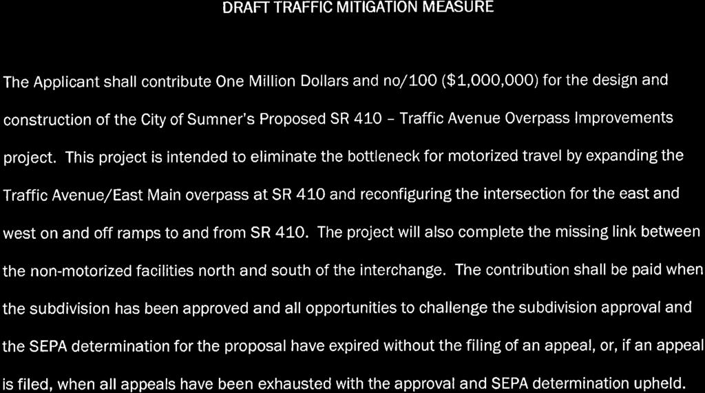
1 1 of 13 Funding Application Competition Application Type Status Submitted: Prepopulated with screening form? Regional FHWA Corridors Serving Centers submitted April 19th, :37 PM Yes Project Information 1. Project Title SR 410/Traffic Ave Bottleneck Improvements 2. Regional Transportation Plan ID Sponsoring Agency Sumner 4. Cosponsors N/A 5. Does the sponsoring agency have "Certification Acceptance" status from WSDOT? Yes 6. If not, which agency will serve as your CA sponsor? N/A Contact Information 1. Contact name Michael Kosa 2. Contact phone Contact Project Description 1. Project Scope The City of Sumner, in conjunction with funding partners, is seeking PSRC funds needed to construct a parallel bridge over SR 410. This project will add capacity to Traffic Avenue and improve the functional operation of the SR 410/Traffic Avenue Interchange. This project will reconfigure two intersections of a congested highway interchange and add two lanes plus a shared-use path on a new parallel bridge structure across SR 410. The improvements will facilitate the movement of vehicles, freight, pedestrians, and bicycles safely and efficiently through the interchange while encouraging ridership on Sound Transit commuter trains and support for South Sound businesses both independent Main Street businesses and large regional and national distribution centers. This project s diverse benefits reflects its diverse funding partners, who, to date, include Sound Transit, the Washington State Legislature, Federal STP funds supporting design efforts, the Washington State Freight Mobility Strategic Investment Board, the Port of Tacoma, and private development. In the spirit of WSDOT's Practical Design concept, the project will repurpose the existing, structurally sound bridge to accommodate two southbound lanes while eliminating the
2 structurally sound bridge to accommodate two southbound lanes while eliminating the bottleneck by adding two northbound lanes and shared-use path on a parallel forwardcompatible bridge structure, resulting in a four-lane roadway section. This project will reconfigure intersections at each end of the existing SR 410 overpass, providing access to the SR 410 ramps and connecting to SR 167 and SR 512. The project will connect to Puyallup s Riverwalk Trail, the Sumner Link Trail and Pierce County s Foothills Trail system. Non-motorized facilities, consisting of sidewalk improvements and a new 14-foot shared use path on the bridge structure, will be constructed to provide an ADA-compliant pathway along Traffic Avenue to the Sound Transit Sounder Train Station. The improved facility will support access to the expanding Sumner Sounder Station, further development and improved operation the Sumner-Pacific Manufacturing Industrial Center, and more opportunities for regional commerce and family-wage jobs in the South Sound where housing is booming. 2. Project Justification, Need, or Purpose This project will eliminate the final bottleneck on a major corridor for vehicular traffic, freight, transit commuters, and bicycle routes. Tens of millions in transportation dollars were invested to widen roads and build trails on either side, but now, Traffic Avenue's outdated two-lane bridge over SR 410 and associated ramp terminal intersections causes substantial delays, backing up traffic over 1/2 mile in Sumner, Puyallup, from Edgewood and even from Bonney Lake onto the SR 410 ramps. Caught in the delays are 11,000 commuters headed to jobs in the Sumner-Pacific Manufacturing Industrial Center, freight traffic on a designated truck route, local traffic accessing Sumner Town Center, East Pierce Fire's response to accidents on SR 410, SR 167, and SR 512 and commuters for Sound Transit trains and buses as well as the buses themselves. Presently, backups from this intersection not only impact flow on Sumner s and Puyallup s arterial streets, but queuing on the SR 410 off-ramps extend to the point of impacting mainline travel on westbound SR 410 as well as the SR 512/SR 167 interchange west of the project. This section of the transportation network presently serves a wide variety of key transportation needs. 1) FREIGHT MOBILITY & EMPLOYMENT: The project serves as one of three truck access points for the Sumner/Pacific Manufacturing Industrial Center and the closest access point to the Port of Tacoma. It has a T-2 designation, carrying over 4 million tons of freight each year. In conjunction with other recently completed transportation projects immediately to the south, this project will see significant freight and commuter traffic increases with the development of Puyallup's future Shaw-Pioneer manufacturing area. 2) RESIDENTIAL/RECREATIONAL TRAFFIC: This interchange is a primary highway access point for residential communities in Sumner, Edgewood, and the Shaw Road area of Puyallup and Pierce County. In addition, during the Washington State Fair, WSDOT routes all traffic coming from King County through this interchange to access the fairgrounds. 3) TRANSIT ACCESS: This route is the primary highway access point for commuters and regional buses utilizing the Sumner Station Sounder rail and bus service, connecting nearby communities with Seattle and Tacoma. Resolution of these bottleneck issues has been identified within State Environmental Policy Checklist (SEPA) completed for the construction of additional parking facilities at Sound Transit's Sounder Train Station. 4) NON-VEHICULAR TRAVEL: Existing non-motorized facilities in the project area do not meet current ADA or City standards. The Traffic Avenue overpass contains a single five-foot (5') wide sidewalk. Pedestrians are forced from the sidewalk onto the narrow, paved shoulder of Traffic Avenue leading to approximately 280 feet of path prior to connecting to Sumner's pedestrian sidewalk network. 5) EMERGENCY SERVICES: This interchange is East Pierce Fire and Rescue s main route for responding to emergencies on the SR 410, SR 167 and SR 512 highways, all main commuter routes that routinely experience collisions. This interchange is also the main route for evacuation or services to/from the valley floor in the event of a major emergency such as a train derailment or lahar. 6) ENVIRONMENTAL SUSTAINABILITY: Reductions in congestion due to this bottleneck will improve regional connectivity, and reduce commercial vehicle idling times with corresponding reductions in air quality due to emissions. Project Location 1. Project Location Traffic Avenue at SR 410 Interchange 2. Please identify the county(ies) in which the project is located. Pierce 3. Crossroad/landmark nearest the beginning of the project Puyallup River Bridge 4. Crossroad/landmark nearest the end of the project Thompson Street 5. Map and project graphics Map_and_Project_Graphics.pdf 2 of 13
3 Plan Consistency 3 of Is the project specifically identified in a local comprehensive plan? Yes 2. If yes, please indicate the (1) plan name, (2) relevant section(s), and (3) page number where it can be found. Sumner Six-Year Transportation Improvement Plan, Item A2 The Sumner Transportation Plan 2015, Item R11, Page 91 identifies, "The Plan Identifies a need for major widening of the Traffic Avenue/SR 410 interchange. The improvement would include additional lanes on the eastbound off-ramp and westbound on-ramp, in conjunction with additional turn lanes at the ramp intersections. These improvements would serve traffic from Sumner as well as Pierce County and Puyallup." Specific references to the project within the Sumner Transportation Plan can be found on pages 86, 89, 91, 118, 128, 132, 133, and 134. Traffic Avenue is identified as an Existing Truck Route on both the Sumner and Puyallup Transportation Plans. 3. If no, please describe how the project is consistent with the applicable local comprehensive plan, including specific local policies and provisions the project supports. In addition, please describe how the project is consistent with a transit agency plan or state plan, if applicable. N/A Federal Functional Classification 1. Functional class name 14 Urban Principal Arterial Support for Centers 1. Describe the relationship of the project to the center(s) it is intended to support. For example, is it located within a designated regional, countywide or local center, or is it located along a corridor connecting to one of these areas? This project will support regional and local centers as a vital corridor link between the regional Sumner-Pacific Manufacturing Industrial Center and a number of other manufacturing and residential centers. The project limits are within Sumner Town Center, a designated center of local importance. It also supports the development of centers throughout Pierce County by being the main connection for transit service, employment and emergency services. Criteria: Benefit to Regional Growth or Manufacturing/Industrial Center 1. Describe how this project will benefit or support the housing and employment development in a regional growth center(s) and/or employment growth in a manufacturing/industrial center(s). Does it support multiple centers? Please provide a citation of the relevant policies and/or specific project references in a subarea plan or in the comprehensive plan. This project supports the continued employment growth in the Sumner/ Pacific Manufacturing Industrial Center. Currently, the MIC includes an estimated 11,000 employees. It can grow to 20,000, but potential employers first ask what s being done to relieve congestion. Being strategically located within 8 miles of the Port of Tacoma and 45 miles from the Port of Seattle and served by 2 railroads and freeway access with developable land, the Sumner-Pacific MIC has potential for future growth. The SR 410 Traffic Avenue Interchange project will serve the Sumner-Pacific MIC with improved access to the Port of Tacoma via SR 410 and other markets to the south via SR 512 and I-5. The improvements will also serve the City of Sumner s Town Center area which is a Center of Local Importance designated for housing growth around the Sumner Commuter Rail Station and historic downtown, expected to add dwelling units. This project also improves access to employment opportunities in Puyallup's future Shaw-Pioneer manufacturing area. This connection allows thousands of commuters to access jobs in the employment centers of Seattle and Tacoma. This project s importance was highlighted when it was directly identified in the 2015 Sumner Transportation Plan, Project ID R11-Traffic Ave/SR 410. In addition, the SEPA documents for the proposed Sound Transit parking garage in Sumner has identified this project as the most significant access barrier to the station. Sumner s long-planned parking garage does not get built if this interchange is not fixed or underway because it does no good to build a garage that no one can access. This station, and its planned expansion, is critical for serving the booming housing areas of Bonney Lake, Tehaleh, Orting, South Hill, Edgewood and unincorporated Pierce County. The region s growth will only be successful if residents can
4 unincorporated Pierce County. The region s growth will only be successful if residents can 4 of 13 access transit options to access jobs, recreation and other services. Comprehensive Plan, Land Use Element Policies: 5.13 Create new housing units in the town center in close proximity to the train station and existing businesses; 5.15 Encourage more mixed commercial/service/housing uses in the Town Center, along Traffic and Fryar Avenues. Reduce light industrial zoning in the Town Center in favor of mixed-use zoning; 5.16 Market to and attract new business compatible with long-range plan and zoning intents, and strengthen and increase the variety of commercial shopping and service opportunities for the community. Comprehensive Plan, Transportation Element Policy: 2.1 Coordinate the development and implementation of the Sumner Transportation Plan with the State Highway Systems Plan Working with the State to fund and implement improvements such as improvements to Traffic Avenue and SR 410 interchange in Sumner. 2. Describe how the project provides or benefits a range of travel modes to users traveling to/from centers, or if it provides a missing mode. The project will improve pedestrian and bicycle access to the Town Center and to the Sounder Commuter Rail Station. Currently there are bike trails and sidewalks that are brought within ¼ mi. of the Sounder Station from the Foothills Trail, Sumner Link Trail, and sidewalks. However, the existing overpass has narrow sidewalks and lacks a sidewalk connection from north of the interchange to the station and neighborhoods. The project would substantially improve these conditions by providing a 14 wide shared use path, with plenty of room for two-way pedestrian and non-motorized vehicle transportation. The project will benefit a large number of users traveling by the following modes: Pedestrian where there is currently a 5 sidewalk on one side of the SR 410 overpass and no walkway between the overpass and the City s sidewalk network, the project will provide a 14 shared use path providing safe and comfortable connections. Bike there are currently no bicycle facilities on the bridge, so cyclists must share the narrow travel lanes with vehicles and tractor-trailers to cross the bridge. The project will provide a 14 shared use path which will provide a separated facility for bikes and will fill a gap in the regional trail network. Bus This interchange is a key component of Sound Transit s Bus Routes 578 connecting Puyallup and Sumner to Auburn, Federal Way and Seattle and 596, linking the consistently-full Bonney Lake Park & Ride with Sounder trains. This same route is used by Beyond the Borders, offering daily transit for seniors, disabled and low-income individuals to connect to jobs, medical appointments and the Pierce Transit system. These services will be benefitted by relieved congestion. Train Sound Transit s Sounder service is extremely popular, and the majority of Sounder riders come through the interchange to access the Sumner Station. The project will benefit train riders by reducing the delay and variability of travel time to and from the station. Automobile Motorized users gain two general purpose lanes, eliminating a bottleneck that has been leading five lanes of traffic to a two-lane bridge for over a decade. The interchange operates at a LOS F during PM peak commuting and residents and regional commuters alike are stuck in the traffic radiating in every direction. Commercial Vehicles This interchange provides a primary route to commercial traffic traveling from the Sumner/ Pacific Manufacturing Center to the Port of Tacoma and other South Puget Sound destinations. An indirect effect of this project will be to reduce commercial vehicle dependence on the section of SR 167 between 24th Street and the SR 512 interchange. That section of SR 167 is already over capacity and experiences significant delays throughout the day as trucks reroute to avoid this bottleneck. 3. Describe how the project will benefit a variety of user groups, including commuters, residents, and/or commercial users. The project will benefit a variety of user groups. Commuters will have substantially improved access to the Sumner Commuter Rail Station in all modes, especially automobiles. The improvements will reduce back-ups and delays at intersections because of improved efficiencies and flow. Residents, likewise, will benefit from these improvements, especially during the PM peak hour times. Currently, residents are caught in back-ups with commuters at that time. Finally, improved efficiencies will benefit commercial truck operations serving the Sumner-Pacific MIC and the downtown businesses, including car dealerships in the area. This project serves two distinct groups of commuters: 1) Those using Sound Transit to commute regionally - the Sound Transit SEPA process determined that this project is a condition of building a much needed parking garage to get more commuters off the highway and onto mass transit. Currently, approximately 1,000 riders access the station daily. Sound Transit estimates that to increase to 1,500 riders by ) Those accessing jobs in East Pierce County - These include over 11,000 jobs in Sumner s Manufacturing Industrial Center with diverse employers including GKN Aerospace (building Boeing winglets) to Costco distribution. These are key, family-wage jobs that are often available to individuals with less education than the high-tech communities north of Sumner. Another Pierce County Employment zone served by this project is the future Shaw-Pioneer Manufacturing Area, anticipated to add over 3 million square feet of manufacturing area in the near future. Residents: This project is the main access from regional highways to historic, downtown Sumner, typically home to older, lower-income households. This route also serves residents trying to access South Hill as well as Bonney Lake, Orting, Tehaleh, Edgewood and downtown Puyallup.
5 Puyallup. 5 of 13 Commercial small business: This project is the main access point for Sumner s historic downtown business district, comprised of small, independent businesses and services including dentists, doctors, lawyers, and pharmacy. Congestion backs into the downtown, tying up Main Street, as well as surrounding larger, regional businesses such as Sunset Chevrolet, McLendon Hardware and The Old Cannery Furniture Store. Commercial-Industrial: Project is a primary truck route for the Sumner-Pacific MIC, especially to access Port of Tacoma, already a funding partner for this project. Trucks may also use the 24th Street interchange to travel south on SR 167; however, that same stretch now experiences routine congestion through significant portions of the day. The project has already been awarded $2.5 Million in construction from the Freight Mobility Strategic Investment Board due to its importance to the freight community. Emergency Response: East Pierce Fire & Rescue s busy Station 13 is located two blocks from this project. The Sumner Police station is approximately half a mile away. This interchange is the route emergency vehicles use to respond to collisions/incidents on SR 410, SR 167 and SR Describe how the project will benefit minority and low-income populations as identified in the President s Order for Environmental Justice, seniors, people with disabilities, those located in highly impacted communities, and/or areas experiencing high levels of unemployment or chronic underemployment; please be specific and provide data where applicable. The project will benefit seniors, people with disabilities and areas located within close Pierce County that may be experiencing higher than normal levels of unemployment. The project improves access to a regional transit facility and employment center and thereby improving transportation and commute options for groups that may have difficulty accessing these jobs or other resources. Per the PSRC Project Selection Resource Map, the population immediately surrounding the project is 17% disabled, 14% below the poverty level, 17% elderly, and 21% minority. The area is categorized by a low opportunity index, which includes most of Sumner and extends west to Edgewood and Fife. Some areas to the west of the project are characterized by a very low opportunity index. Areas labeled as highly impacted communities are located nearby to the north and east of the project. In addition, according to the Association of Washington Cities (AWC), the immediately adjacent residential area on the Sumner side of this interchange has a Diversity Index of This interchange also serves neighborhoods to the north and east, which are and On the Puyallup side of this interchange, the immediately adjacent areas register an index of Given that the Diversity Index map shows that most of Eastern Pierce County ranges from 4 to 28, the areas directly served by this project are more diverse than is typical in this region. Benefits to Senior/Disabled: Sumner and Pierce County work together to provide Beyond the Borders, a free shuttle service for low-income, youth, seniors and disabled individuals. Fixed routes and even door-to-door service help get individuals to jobs, doctor s appointments and connect to the Pierce Transit system. The shuttle uses this overpass and two intersections to make that connection. Congestion can hinder the shuttle s ability to make connection to Pierce Transit, negatively impacting its ability to serve these vulnerable populations. Benefits to Minority/Low-Income/Senior: PSRC s Resource Map indicates that Sumner is considered a Low Opportunity community and Pierce County between Sumner and Puyallup is considered Very Low Opportunity. The Kirwan Institute report further analyzes that Sumner s Education Opportunity is high, Economic Health is moderate to low, Housing is moderate to low, Health & Environment is very high. Only transportation/mobility rates very low for all of Sumner and its surrounding environment. Relieving congestion that hinders the Beyond the Borders shuttle also benefits these populations. In addition, this project builds safe, easy access to 11,000 family-wage industrial jobs via vehicle, non-vehicular access and transit. The best way to benefit low-income and minority groups is to eliminate obstacles to good jobs that require hard work rather than high degrees. Of note, AWC s data shows that in 2013, Pierce County had an in-state migration of over 2,400 people, most of whom came from King County. King County lost over 6,000 people who moved within state in that same year. The numbers back up the regional acknowledgement that Pierce County is King County s affordable housing program, and the growth is primarily going to eastern Pierce County. Many of those residents seeking affordable housing travel through this interchange to access local jobs, regional jobs, and commercial services. 5. Describe how the project will support the establishment of new jobs/businesses or the retention of existing jobs/businesses including those in the industry clusters identified in the adopted regional economic strategy. The Sumner-Pacific MIC boasts 11,000 jobs and companies continue to move here and expand here due to the access to the ports, affordable housing, and their labor force. The MIC contains jobs 3,400 jobs in transportation, distribution and logistics, 640 in food and beverage processing, 540 in wood products, and over 300 in aerospace. The aerospace cluster alone includes 6 firms such as AIM Aerospace, Composite Solutions and GKN. The project will improve transportation access for these businesses both for commuters and would reduce freight and transportation costs. These benefits would also apply to Sumner s downtown businesses. As discussed on page 16 of Amazing Place: Growing Jobs and Opportunity in the Central
6 As discussed on page 16 of Amazing Place: Growing Jobs and Opportunity in the Central Puget Sound Region, the South Sound has a strong Transportation and Logistics sector and Building on these strengths and supporting these industries and businesses is a key component to any effort to develop the sub-economies of the region. Finding synergies between the industries and sub-regions will strengthen both the parts and the whole. The Sumner-Pacific MIC is built primarily on the Transportation and Logistic sector with distributions facilities for Costco, McDonald s, Amazon, and other major distributers. Primarily trucking-based, these businesses need sufficient transportation infrastructure facilities to operate effectively and draw future business to the region. Small cities are also identified as key to growth, with these areas offering proximity to recreation, natural resources, and workforce vital to surrounding urban centers. (Page 17, Amazing Place: Growing Jobs and Opportunity in the Central Puget Sound Region). The opportunities of small business growth, emerging industry development, and living wage jobs provided by centers like the Sumner-Pacific MIC and Sumner Town Center of Local Importance are a key strategy to achieving the regional goal of providing economic opportunities to everyone. With the region expanding at an increased rate, thousands of homes are being planned just south of Sumner. The new 4.5-story Sound Transit parking garage that relies on this project to be built is expected to be full on opening day. Our entire region has a vital need to remove the bottleneck of SR 410/Traffic Avenue interchange to improve transportation infrastructure and facilitate regional growth. From an employer prospective, companies ranging from GKN Aerospace to SEFNCO have already asked what s being done to keep freight and people moving efficiently through this region. They identify this bottleneck as one of the worst barriers to efficient routes and effective business models. The regional MIC designation process already identified that this area is one of the last remaining spaces to develop large manufacturing within the Puget Sound region. 6 of 13 Criteria: System Continuity/Long-Term Benefit and Sustainability 1. Describe how this project supports a long-term strategy to maximize the efficiency of the corridor, including TDM and activities and ITS improvements that use advanced technologies or innovative approaches to improve traffic flow. Describe the problem and how this project will remedy it. This project clearly improves the short- and long-term strategy for the corridor. By removing the bottleneck at a major interchange, this project eliminates the congestion that significantly hampers traffic through the area. The project will entirely replace both signals at the on-and off-ramps and provide modern signals with the most up-to-date technology. The signals will be compatible with the rest of WSDOT s ITS system and can be connected in the future as desired. The system will also be able to be tied to the other signals on Traffic Avenue if needed, leading to further signal efficiencies in the corridor. The project will utilize Transportation Demand Management (TDM) by leaving the existing, structurally sound facilities in place while the new overpass structure is constructed, minimizing further disruption to existing traffic patterns. Transportation System Management (TSM) can be incorporated into the project by detouring Sound Transit's Bus Service from Bonney Lake through the Valley Avenue/ SR 410 interchange during construction, thereby reducing traffic demand on the work zone during construction activities. 2. Describe how this project provides a logical segment that links to a regional growth or manufacturing/industrial center. There is no question that this project provides a logical segment. Surrounded by SR 167 and SR 410, the Traffic Avenue MIC access point is one of five highway interchange Sumner roadway access points. Given other constraints such as the Puyallup and White Rivers and designated truck routes, this project is one of three truck access points to the Sumner- Pacific MIC. The access point is the closest route for freight to and from the Port of Tacoma and commuters to and from Puyallup s Downtown or South Hill growth centers. Previous capacity improvements on Traffic Avenue and East Main have widened the roads serving this corridor to five (5) lane arterials. This project would complete the final and central segment of Transportation 2040 Project 500. Other significant regional projects include: The East Main Bridge over the Puyallup River immediately adjacent to the project, Shaw Road Widening Project (PSRC Transportation 2040 Project 494), The Shaw Road extension that provides a grade separation over BNSF rail tracks (PSRC Transportation 2040 Project 1222), The Bridge Street Bridge Replacement Project north of the project that will connect this area to southwest portion of the Sumner Pacific MIC (PSRC Transportation 2040 Project 499), Sound Transit's Sumner Station Improvements (PSRC Transportation 2040 Project 4083) The project is also a logical connection from the Sumner Link Trail, the Riverwalk Trail, and the Foothills Trail to the Sound Transit Sounder Train Station. 3. Describe how the project fills in a missing link or removes barriers to/from a center. This project would be the final component of the PSRC Project identified as Transportation
7 This project would be the final component of the PSRC Project identified as Transportation 7 of ID 500. This project widened E. Main/Traffic Avenue to accommodate five (5) travel lanes over the Puyallup River and five (5) travel lanes between Harrison and Main Street. This project would add additional travel lanes in between, linking these two sections to remove a barrier between SR 410 and the Sumner/ Pacific Manufacturing Industrial Center. Until this final segment is complete, all the previous investments will not recognize their full benefit to increasing regional mobility. The project also provides non-motorized facilities to fill a gap in the system and connects the Sumner Link Trail, Riverside Trail, and Foothills Trail to the Sound Transit Sounder Train Station. Presently, the Traffic Avenue overpass above SR 410 is a non-ada compliant sidewalk that frighteningly discharges onto a narrow roadway shoulder. This project would provide the missing link between the City's sidewalk system and the three trailheads. 4. Describe how this project will relieve pressure or remove a bottleneck on the regional transportation system and how this will positively impact overall system performance. This project is a picture-perfect example of a bottleneck on a regional transportation system. The two-lane bridge limits transportation into Sumner for residents, commuters, and commerce alike. Removing this bottleneck will free users from gridlock and improve the pedestrian facilities to provide more opportunities for all users to access Sumner and the Sumner-Pacific MIC. SR 167 commuters and train riders that utilize the Sounder station will be of particular benefit, as the new 4.5-story parking garage will be able to be built and accessed more easily, increasing the appeal of commuter train operations. The project will improve two intersections presently operating at Level of Service F. Backups from these intersections extend to Shaw Road in the South (approx. 0.6 mi); to Puyallup Street in the North (0.5 miles), across Bridge Street to the west, Main Street and Thompson Street to the east; and onto the SR 410 access ramps where queuing can extend onto westbound SR 410 and the SR 512/ SR 167 interchange to the west. By increasing access to and facilitating the expansion of the Sound Transit Sounder Train Station, the project will decrease the region's reliance on the highway system and reduce traffic on SR 167 which already is already over capacity. 5. Describe how this project addresses safety and security. The new parallel bridge will meet current roadway and bridge design standards, improving roadway and pedestrian safety alike. Bridge rails will be constructed to meet current safety standards, and concrete barriers and guardrail will have appropriate terminal end sections. The bridge structure itself will be designed to survive current earthquake design events, a great benefit to anyone in the area as Traffic Avenue is a volcano/lahar evacuation route. The existing bridge, which met current bridge standards at the time it was constructed, is on a timber pile foundation and was not designed to current earthquake standards. Regarding security, the shared-use path will be separated from vehicles by a concrete barrier, a substantial improvement to the existing condition. New fencing will protect people and the roadway below from anything falling from the existing or proposed structure. Intersections will be constructed to meet current ADA standards, increasing the safety of the intersection and standardizing the intersection to provide an up-to-date user experience. The signal phasing will provide improved control over vehicles and provide a safer experience than the existing permissive left turns. The project will greatly improve non-motorized safety by providing non-motorized facilities to replace the unsafe and narrow walkway on the existing overpass and the narrow shoulder of Traffic Avenue. In field visits with Sound Transit's staff, several refused to walk the corridor citing safety concerns. The project will improve East Pierce Fire and Rescue's ability to respond to emergencies in Sumner, Bonney Lake, East Puyallup, and in significant stretches of SR 410, SR 512, and SR Describe how the project provides opportunities for active transportation that can lead to public health benefits. Active transportation is a key benefit of this project. The project provides the final missing pedestrian link between Sumner and Puyallup across SR 410 and connects the Sumner Link Trail and Puyallup s Riverwalk trail to the Sound Transit station and Sumner Town Center. Without these improvements utilizing only paved walking surfaces, a 1/8th-mile walk from the west side of the bridge to the Sumner station turns into a ¾-mile walk, increasing walking travel time by 10 minutes or more. Adding this important connection also provides another regional link between Sumner Town Center and the Foothills Trail, and important recreational trail. The health benefits of walking, biking, or hiking for recreational purposes are significant, and the ability to transport commuters to the Sumner Station via a new trail connection will lower congestion and improve air quality due to a reduction of vehicles through the intersection. Air Quality and Climate Change: Element Selection 1. Please select one or more elements in the list below that are included in the project s scope of work, and provide the requested information in the pages to follow. Roadway Improvement, Bicycle and Pedestrian Facilities, Intelligent Transportation Systems
8 Air Quality and Climate Change: Roadway Improvement 8 of What is the length of the project? 0.4 Miles along Traffic Ave 2. What is the average daily traffic before and after the project? The average daily traffic is 18,500 in the project area and is not expected to change after completion of the project outside of typical background growth rates. 3. What is the average speed before and after the project? The posted speed limit along Traffic Avenue is 25 mph. During the PM peak hour of the design year 2035, the average speed will improve from 15 mph to 34 mph for northbound Traffic Ave and from 3 mph to 21 mph for southbound Traffic Ave. 4. What is the average daily transit ridership along the corridor? N/A 5. How many daily peak period transit trips serve the corridor? N/A 6. What is the expected increase in transit speed due to the BAT/HOV lanes? N/A 7. What is the expected increase in transit ridership due to the BAT/HOV lanes? N/A 8. What is the percentage of freight truck traffic on the facility? AM Peak 4.5% EB Ramps, 6% WB Ramps 9. Will the project result in shorter trips and reduced VMT? If so, please explain. The project will greatly reduce delays, but will not reduce the distance travelled. Both intersections in the project area are expected to experience shorter delays, so the project will result in shorter trips for all users, including Sound Transit bus service and freight truck traffic to manufacturing and industrial areas. The project will also remove nearly a ¼ mile of parallel parking, which will encourage users to seek alternative modes of transportation and reduce the vehicle miles traveled. 10. Please describe the source of the project data provided above (e.g., Environmental Impact Statement, EPA/DOE data, traffic study, survey, previous projects, etc.). The speed data (question 3) comes from the Transportation Technical Report for the Sumner Sounder Station Access Improvements Project, dated March The heavy vehicle data (question 8) and trip length data (question 9) come from the SR 410/Traffic Avenue Overpass Improvements Intersection Control Analysis, dated August Air Quality and Climate Change: Bicycle and Pedestrian Facilities 1. Describe the facilities being added or improved Non-motorized improvements include a new 14 wide shared-use path, two reconstructed traffic islands at the SR 410 WB Ramps and Thompson Street, and reconstructed sidewalk and curb ramps along Traffic Avenue. 2. What is the length of the proposed facility? Approximately 750 feet 3. Describe the connections to existing bicycle/pedestrian facilities and transit. The new bicycle pedestrian facilities will connect to the Sumner Link Trail, Puyallup Riverwalk Trail, and Pierce County Foothills Trail on the south end of the project and to the Sound Transit Sounder Train Station and the City of Sumner s sidewalk system and Sumner Town Center on the north end of the project. 4. Describe the current bicycle/pedestrian usage in the project area. If known, provide information on the shift from single occupancy vehicles. Bicycle/pedestrian traffic is limited in the project area, with less than 100 bicyclists and pedestrians per day. Currently, some Sound Transit commuters park on the widened shoulder of E Main Avenue south of the project and walk to the Sounder Train Station. The existing path is not ADA accessible and is not separated from motorized vehicles. 5. What is the expected increase in bicycle/pedestrian usage from the project? If known, provide information on the shift from single occupancy vehicles Ridership at the Sound Transit Sounder Train Station is expected to increase from 1,000 daily riders to approximately 1,500 by Non-motorized travel is expected to double in proportion to the Sounder Station growth and may increase substantially as residential densities increase in the Sumner Town Center area. The presence of a bicycle facility crossing SR 410 is estimated to increase commuter bike
9 The presence of a bicycle facility crossing SR 410 is estimated to increase commuter bike travel to the Sounder Station by an additional 40 daily round trips during the week. Recreational bike ridership has not been estimated, but it is expected to increase substantially once the connection between the Sumner residential areas and the Puyallup Riverwalk Trail and Pierce County Foothills Trails is completed. 6. What is the average bicycle trip length? N/A 7. What is the average pedestrian trip length? N/A 8. Please describe the source of the project data provided above (e.g., Environmental Impact Statement, EPA/DOE data, traffic study, survey, previous projects, etc.) Sound Transit ridership data (question 5) comes from the Land Use Targets Maintenance Release 1, dated April Commuter bicycle data (question 5) comes from the Sound Transit Sounder Station Access Study, dated September of 13 Air Quality and Climate Change: Intelligent Transportation Systems and Corridor Efficiency 1. What is the existing level of service? LOS D EB ramps during PM peak 2. What are the existing number of lanes (in one direction)? Single lane in each direction 3. What is the existing average daily traffic? 18, What is the existing average speed? 15 MPH NB/3 MPH SB during PM Peak 5. What are the ITS improvements being provided? Improvements include traffic signal interconnect and spare conduits that may be used for futured closed circuit video cameras, changeable message signs, highway advisory radio and/or ramp meter/data stations. 6. How many intersections are being improved? 2 7. What is the length of the project? 0.4 Miles 8. What is the percentage of freight truck traffic in the project area? 3% 9. What is the expected improvement to level of service? The project will result in improved level of service for both intersections. During the PM peak hour of the design year 2035, both intersections are expected to operate at LOS C. Without improvement, both intersections are expected to operate at LOS F in What is the expected improvement to average speed? During the PM peak hour of the design year 2035, the average speed is expected to be 34 mph for northbound Traffic Ave and 21 mph for southbound Traffic Ave. 11. What is the expected improvement to average vehicle delay? The project will result in improved average vehicle delay for both intersections. During the PM peak hour of the design year 2035, the Traffic Avenue/SR 410 EB Ramps intersection is expected to experience a 25-second delay (compared to 150 seconds for the future no-build condition) and the Traffic Avenue/SR 410 WB Ramps intersection is expected to experience a 30-second delay (compared to 100 seconds for the future no-build condition). 12. Please describe the source of the project data provided above (e.g., Environmental Impact Statement, EPA/DOE data, traffic study, survey, previous projects, etc.) The speed data (questions 4 and 10) comes from the Transportation Technical Report for the Sumner Sounder Station Access Improvements Project, dated March The level of service data (questions 1 and 9), heavy vehicle data (question 8) and vehicle delay data (question 11) come from the SR 410/Traffic Avenue Overpass Improvements Intersection Control Analysis, dated August PSRC Funding Request 1. What is the PSRC funding source being requested?
10 STP 2. Has this project received PSRC funds previously? No 3. If yes, please provide the project's PSRC TIP ID N/A 10 of 13 Phase Year Alternate Year Amount construction $4,700, Total Request: $4,700, Total Estimated Project Cost and Schedule Planning Funding Source Secured/Unsecured Amount Local Secured $90, Other State Secured $300, Expected year of completion for this phase: 2018 PE $390, Funding Source Secured/Unsecured Amount STP Reasonably Expected $313, Local Secured $11, Local Secured $75, Local Secured $1,564, Other State Secured $500, Expected year of completion for this phase: 2018 Construction Funding Source Secured/Unsecured Amount $2,463, FMSIB Secured $2,500, STP(U) Unsecured $4,700, Local Secured $1,000, TIB Unsecured $1,945, Local Secured $3,436, Expected year of completion for this phase: 2021 Summary 1. Estimated project completion date Total project cost $16,434, Funding Documentation $13,581,046.00
11 1. Documents Funding_Support_Data_ _Flat.pdf Please describe the secure or reasonably expected funds identified in the supporting documentation. For funds that are reasonably expected, an explanation of procedural steps with milestone dates for completion which will be taken to secure the funds for the project or program should also be included. The following is submitted in support of the Planning Phase funding sources listed: Local, $90,000 - The City of Sumner's executed budget worksheet showing funding authorized in 2017 for this project. As has been the case with past projects, the City anticipates authorizing funding to ensure that local participation matches required in federal and state funding awards are met or exceeded. Other State, $300,000 - Documentation from Washington State 2016 Supplemental Transportation Funding is provided in the form of an award letter showing project support and identifying the awarded funds. The following is submitted in support of the Preliminary Engineering Phase funding sources listed: Federal STP, $313,000 - The Pierce County Regional Council (PCRC) Transportation Coordinating Committee (TCC) recommended that PCRC direct $313,000 in available STP Contingency funds to the project at a meeting on April 5, A letter from the TCC chairman is provided, which is the most recent formal documentation available. The PCRC will be reviewing TCC's recommendation at their meeting on April 19, Local, $11,500 - Documentation from the Port of Tacoma is provided in the form of a letter showing project support and identifying the awarded funds. Local, $75,000 - Documentation from Schnitzer West is provided in the form of a letter showing project support and identifying the funds committed. Local, $1,564,000 Documentation from Sound Transit is provided in the form of an approved motion by Sound Transit to the City of Sumner committing $150,000 and $1,523,000 to the project design phase for a design phase total $1,673,000. Unused design funds can be rolled into construction funds, so the project shows $1,564,000 in PE and $3,436,000 in the construction phase (When added to construction phase, Sound Transit s contribution totals $5,000,000). Other State, $500,000 - Documentation from Washington State 2018 Supplemental Transportation Funding is provided in the form of an award letter showing project support and identifying the awarded funds. The following is submitted in support of the Construction Phase funding sources listed: FMSIB, $2,500,000 Documentation from FMSIB is provided in the form of an award letter showing project support and identifying the awarded funds. STP, $4,700,000 This request Local, $1,000,000 Documentation from Knutson development is provided in the form of a letter showing project support and identifying the funds committed. TIB, $1,945,046 Funds are unsecured. The project will be applying for funds during the 2018 funding cycle. Local $3,436,000 - Documentation from Sound Transit is provided in the form of an approved motion by Sound Transit to the City of Sumner committing a minimum $3,327,000 to the construction phase. Unused design funds can be rolled into construction funds, so the project shows $1,564,000 in PE and $3,436,000 in the construction phase (When added to the design phase, Sound Transit s contribution totals $5,000,000). If this project is selected by PSRC to receive the full funding request, the overall project will be nearly 90% funded. If TIB construction funds are not awarded (and there are multiple cycles of TIB awards before the STP funds are available), support from other partners such as the Washington State Legislature, the City of Puyallup, WSDOT, Pierce County, Sound Transit, and others would be potential funding partners. The City of Sumner will also weigh its ability to commit transportation funds to this important and regionally significant project. It is doubtful that this project will not be able to be successful in securing a final $2 million dollars from another source if TIB funds are not awarded. Regarding the developer funds, per the MDNS issued by Pierce County dated April 26, 2017, the funds will need to be paid to the City of Sumner prior to occupancy of the first building within the Knutson Farms Short Plat. It is expected that construction of this development will begin within the timeframe of the project, so funds should be available. If no funds are available at the time of construction, the City will have to find an additional funding source or provide construction funds until the development moves forward. Project Readiness: PE 1. Are you requesting funds for ONLY a planning study or preliminary engineering? No 2. Is preliminary engineering complete? No 11 of 13
12 3. What was the date of completion (month and year)? 04/ Have preliminary plans been submitted to WSDOT for approval? Yes 5. Are there any other PE/Design milestones associated with the project? Please identify and provide dates of completion. You may also use this space to explain any dates above. Design is 60% complete with WSDOT development services and local programs being involved in reviews and monthly meetings. Preliminary documents including an Intersection Control Analysis (ICA), a Transportation Technical Report (TTR), and a Basis of Design (BOD) with Plans For Approval (PFA) have been formally approved by WSDOT. The project has received a Design Approval (DA) from WSDOT as well, marking the completion of the preliminary design process. The only remaining approval is the Project Development Approval (PDA), which cannot be fully approved until construction funds are in place. We expect to have final design for WSDOT review by mid-summer 2018 (this year), years in advance of any PSRC construction funds becoming available. 6. When are preliminary plans expected to be complete? Project Readiness: NEPA 1. What is the current or anticipated level of environmental documentation under the National Environmental Policy Act (NEPA) for this project? Documented Categorical Exclusion (DCE) 2. Has the NEPA documentation been approved? No 3. Please provide the date of NEPA approval, or the anticipated date of completion (month and year) Project Readiness: Right of Way 1. Will Right of Way be required for this project? No 2. How many parcels do you need? N/A 3. What is the zoning in the project area? N/A 4. Discuss the extent to which your schedule reflects the possibility of condemnation and the actions needed to pursue this. N/A 5. Does your agency have experience in conducting right of way acquisitions of similar size and complexity? N/A 6. If not, when do you expect a consultant to be selected, under contract, and ready to start (month and year)? N/A 7. In the box below, please identify all relevant right of way milestones, including the current status and estimated completion date of each. N/A Project Readiness: Construction 1. Are funds being requested for construction? Yes 2. Do you have an engineer's estimate? Yes 3. Engineers estimate document SR410-Traffic_Ave_IC_60 Est_with_Contingencies_ pdf 4. Identify the environmental permits needed for the project and when they are 12 of 13
13 4. Identify the environmental permits needed for the project and when they are scheduled to be acquired. NEPA Approval Are Plans, Specifications & Estimates (PS&E) approved? No 6. Please provide the date of approval, or the date when PS&E is scheduled to be submitted for approval (month and year) When is the project scheduled to go to ad (month and year)? Other Considerations 1. Describe any additional aspects of your project not requested in the evaluation criteria that could be relevant to the final project recommendation and decisionmaking process. N/A 2. Describe any innovative components included in your project: these could include design elements, cost saving measures, or other innovations. Practical design was implemented, and through that process it was determined that the existing bridge would continue to be used rather than demolished. The new bridge consists of 2 additional lanes instead of a 5-lane structure and will be constructed parallel to the existing bridge. The new bridge has been designed to be widened to a 5-lane structure when the existing bridge reaches the end of its useful life and needs to be replaced, resulting in one structure instead of two. These design considerations will reduce funds needed for current project construction and will allow for the project bridge to be widened to carry all traffic when the existing bridge needs to be replaced. 3. Describe the process that your agency uses to determine the benefits of projects; this could include formal cost-benefit analysis, practical design, or some other process by which the benefits of projects are determined. Practical design was implemented, and through that process it was determined that the existing bridge would continue to be used rather than demolished. The new bridge consists of 2 additional lanes instead of a 5-lane structure and will be constructed parallel to the existing bridge. The new bridge has been designed to be widened to a 5-lane structure when the existing bridge reaches the end of its useful life and needs to be replaced, resulting in one structure instead of two. These design considerations will reduce funds needed for current project construction and will allow for the project bridge to be widened to carry all traffic when the existing bridge needs to be replaced. 4. Final documents 2018_Traffic_Ave_Resource_Maps.pdf, Other_Graphics.pdf, _City_of_Sumner_SR_410_Traffic_Ave._Bottleneck_Improvements.pdf 13 of 13

14 Sumner/Pacific Manufacturing Industrial Center South East Edgewood Residential Area EDGEWOOD DR E VALLEY HWY E 167 VALLEY AVE E Sumner Town Center W MAIN ST TRAFFIC AVE Sounder Station Fire Station Sumner VALLEY AVE Puyallup s E Main Commercial Corridor THIS PROJECT E MAIN AVE 410 PUYALLUP RIVER SHAW RD E Puyallup s Future Shaw-Pioneer Manufacturing Area 162 E PIONEER Puyallup Puyallup s South Hill Residential Area PIONEER WAY E Community Context

15 0 SCALE IN FEET 150 RIVERWALK TRAIL SUMNER TRAIL SR 410 APPROX BNSF ROW THOMPSON ST TRAFFIC AVE SUMNER SOUNDER STATION SR410/TRAFFIC AVE. INTERCHANGE IMPROVEMENTS EXISTING CONDITION STATION LANE

16 4 SR 10 VE A FIC AF TR SUMNER SOUNDER STATION R NE M SU SO NS T STA MP TIO NL AN E L AI TR THO APPROX BNSF ROW K AL RW VE RI L AI TR E. M A AIN VE REVISED LEGEND: SCALE IN FEET PROPOSED: STRIPING EDGE OF PAVEMENT PROPOSED NON-MOTORIZED ROUTE EXISTING NON-MOTORIZED ROUTE EXISTING BRIDGE TO REMAIN NEW BRIDGE FOUR 12' GENERAL PURPOSE LANES 14' SHARED USE PATH SR410/TRAFFIC AVE. INTERCHANGE IMPROVEMENTS
17
18 PSRC 2018 Project Selection Resource Map Disabled Legend Sumner City Limits Sumner Town Center Sumner-Pacific MIC 11% Disabled ÜScale: 0 1,000 2,000 Feet E D G E W O O D SR % Disabled 6% Disabled 11% Disabled 5% Disabled A U B U R N S U M N E R 13% Disabled 17% Disabled 13% Disabled P U Y A L L U P Project Location 12% Disabled SR % Disabled 18% Disabled 7% Disabled
19 PSRC 2018 Project Selection Resource Map Elderly Legend Sumner City Limits Sumner Town Center Sumner-Pacific MIC 15% Elderly ÜScale: 0 1,000 2,000 Feet E D G E W O O D SR % Elderly 11% Elderly 10% Elderly 9% Elderly A U B U R N S U M N E R 20% Elderly 10% Elderly P U Y A L L U P 10% Elderly 17% Elderly Project Location SR % Elderly 15% Elderly 5% Elderly
20 PSRC 2018 Project Selection Resource Map Highly Impacted Communities Legend Sumner City Limits Sumner Town Center Sumner-Pacifc MIC ÜScale: 0 1,000 2,000 Feet E D G E W O O D A U B U R N SR-167 S U M N E R Top 10% Impacted Community P U Y A L L U P Project Location SR-410
21 PSRC 2018 Project Selection Resource Map Minority Legend Sumner City Limits Sumner Town Center Sumner-Pacific MIC Ü Scale: 0 1,000 2,000 Feet 34% Minority A U B U R N 12% Minority 16% Minority E D G E W O O D SR % Minority 11% Minority S U M N E R 22% Minority 31% Minority P U Y A L L U P 21% Minority Project Location 17% Minority SR % Minority 18% Minority 23% Minority
22 PSRC 2018 Project Selection Resource Map Opportunity Index Opportunity Index High Opportunity Low Opportunity Moderate Opportunity Very High Opportunity Legend Sumner City Limits Sumner Town Center Sumner-Pacific MIC High Opportunity A U B U R N Very Low Opportunity Ü 0 2,000 Scale: 1,000 Feet Low Opportunity Moderate Opportunity E D G E W O O D SR-167 Low Opportunity Very Low Opportunity S U M N E R P U Y A L L U P Low Opportunity Project Location SR-410 Moderate Opportunity
23 PSRC 2018 Project Selection Resource Map Households in Poverty Legend Sumner City Limits Sumner Town Center Sumner-Pacific MIC 6% Households In Poverty ÜScale: 0 1,000 2,000 Feet E D G E W O O D SR % Households in Poverty 1% Households in Poverty A U B U R N 1% Households in Poverty 8% Households in Poverty S U M N E R 13% Households in Poverty 14% Households in Poverty P U Y A L L U P 5% Households in Poverty 14% Households in Poverty Project Location SR % Households in Poverty 8% Households in Poverty 8% Households in Poverty


24 SR 167 SB HOV/HOT Lane Project to 8th St E ED GE DD RE LLE VA WO O 167 YH WY E Stuck River Bridge PSRC PROJ #499 Y AV EE Sumner Trail SR 167 Corridor PSRC PROJ #2914 Completion PSRC PROJ #1659 & TR AF FIC AV E W MAIN ST 410 Sumner Station Improvements PSRC PROJ #4083 Sounder Station Sumner VALLEY AVE VALL E EM AI N AV E Traffic Ave/Puyallup River Bridge Replacement PSRC PROJ #500 THIS PROJECT 410 P LU L YA PU Puyallup R NEER E RIV E PIO 162 RD E SHAW Shaw Road Extension PSRC PROJ #1222 Shaw Road Widening PSRC PROJ #494 PIONEER WAY E Adjacent Transportation Investments

25 VALLEY AVE E LEGEND Trails 10 Sidewalks Street with Sidewalks EDGEWOOD DR E Sumner Link Trail VALLEY HWY E 167 W MAIN ST TRAFFIC AVE Sounder Station Sumner VALLEY AVE Riverfront Trail THIS PROJECT E MAIN AVE 410 PUYALLUP RIVER SHAW RD E 162 E PIONEER Foothills Trail Puyallup PIONEER WAY E Non-Motorized Facilities


26 Existing Non-Motorized Facilities at the Traffic Avenue/East Main Bottleneck Non-Motorized Facilities between the Existing SR410 Overpass and Thompson Avenue Non-Motorized Facilities at the North end of the Existing SR410 Overpass


27 Existing Non-Motorized Facilities at the Traffic Avenue/East Main Bottleneck Existing SR410 Overpass South Approach Existing SR410 Overpass West Guardrail and Missing Sidewalk


28 Traffic Avenue/East Main Bottleneck Thompson Street from Sound Transit Station on a Typical Evening Commute Traffic Avenue Traveling South on a Typical Evening Commute from Bonney Lake-Sumner Courier-Herald
29 167 JOVITA BLVD E Sumner Recommended Evacuation Routes 8TH ST E 18TH ST E 24TH ST E STEWART RD SW VALENTINE AV SE 136TH AV E 24TH ST E 8TH ST E LAKE TAPPS PKWY E FOREST CANYON RD E Miles 16TH ST E 32ND ST E 36TH ST E WEST VALLEY HWY E 142ND AV E 166TH AV E 122ND AV E 48TH ST E?u@ 167 EAST VALLEY HWY E SUMNER-TAPPS HWY E WEST TAPPS DR E EDGEWOOD DR E SOUTH TAPPS DR E VALLEY AV E?u@ 512?u@ 410 TRAFFIC AV FRYAR AV MAIN ST VALLEY AV MAIN ST E 160TH AV E 64TH ST E E MAIN E PIONEER SHAW RD 74TH ST E Themapfeaturesareapproximateandareintendedonlytoprovideanindicationofsaidfeature.Additional areasthathavenotbeenmappedmaybe present.thisisnotasurvey.orthophotosandotherdatamaynotalign.thecountyasumesnoliabilityforvariationsascertainedbyactual survey. ALLDATAISEXPRESSLYPROVIDED ASIS AND WITH ALLFAULTS.TheCountymakesnowarantyoffitnesforaparticularpurpose.?u@ 162 RIVERSIDE DR E 166TH AV E?u@ 410 MYERS RD E
30 Accident Data Summary Traffic Avenue between Thompson Street and the Puyallup River Bridge Year Number of Accidents (1 st Quarter) 3 Source: Sumner Police Department Accident Report Database Page 1 of 1 Printed: 4/12/2018
31 SR TRAFFIC AVE INTERCHANGE IMPROVEMENTS 60% Cost Estimate Estimate revised 1/30/2018 Total Total Std. Item Unit Item Quantity Unit Price Cost Preparation 0001 LS Mobilization (See Below) 0025 Acre Clearing and Grubbing 1.50 $ 20,000 $ 30, Est Removing Shaft Obstructions 60, $ 1.00 $ 60, Est. Removing Traffic Signal Shaft Obstructions 10, $ 1.00 $ 10, SY Removing Cement Conc. Sidewalk $ $ 5, LF Removing Cement Conc. Curb and Gutter $ $ 5, LF Removing Asphalt Conc. Curb 1, $ $ 11, LF Removing Traffic Island $ $ 21, LF Removing Guardrail $ $ 3, EACH Removing Guardrail Anchor 4.00 $ $ 1, LF Removing Paint Line 3, $ 1.00 $ 3, Each Removing Painted Traffic Marking 6.00 $ $ 2,280 LF Removing Fence $ $ 2,500 Each Removing Signal System 2.00 $ 15,000 $ 30,000 Grading 0310 CY Roadway Excavation Incl. Haul 4,360 $ 30 $ 130, CY Unsuitable Foundation Excavation Incl. Haul 2,180 $ 30 $ 65, Ton Gravel Borrow Incl. Haul 8,300 $ 30 $ 249, CY Embankment Compaction 4,150 $ 12 $ 49,800 Drainage/Storm Sewer 3091 Each Catch Basin Type $ 2,000 $ 22, Each Catch Basin Type 2 48 In. Diam 8.00 $ 7,000 $ 56, LF Schedule A Storm Sewer Pipe 12 In. Diam $ 80 $ 74, LF Schedule A Storm Sewer Pipe 24In. Diam $ 100 $ 6,000 LS Treatment/Detention 131, $ 1.00 $ 131,500 Utilities (See Below) LS Relocation AC Sanitary Sewer and Force Main 105, $ 1.00 $ 105,000 LS Relocation of Water Transmission Main 95, $ 1.00 $ 95,000 Structure 4006 CY Structure Excavation Class A Incl. Haul 1,807 $ 30 $ 54, LS Shoring or Extra Excavation Cl. A 34,738 $ 1 $ 34, LF Constructing 8 FT. Diam Shaft 1,047,459 $ 1 $ 1,047, Each QA Shaft Test 4 $ 2,000 $ 8, LS Superstructure - Traffic Ave Bridge 959,111 $ 1 $ 959, LF Bridge Railing Type BP 141 $ 80 $ 11, LF Traffic Barrier 281 $ 150 $ 42, LF SEW Traffic Barrier 433 $ 315 $ 136,395 LF Railing at East side of Bridge 141 $ 100 $ 14, SF Structural Earth Wall 4,276 $ 60 $ 256, SY Bridge Approach Slab 276 $ 250 $ 69,000 Surfacing 5100 Ton Crushed Surfacing Base Course 1,720 $ 45 $ 77,400
32 Hot Mix Asphalt 5711 SY Planing Bituminous Pavement 5,678 $ 5.00 $ 28, Ton HMA for Preleveling CL. 1/2 In. PG 280 $ 230 $ 64, Ton HMA Cl. 1/2 In. PG 2,580 $ 100 $ 258, Ton HMA Cl. 1/2 In PG (for Overlay) 560 $ 100 $ 56, Ton HMA C. 1/2 In PG (for Traffic Island) 60 $ 100 $ 5, CALC Compaction Price Adjustment 6,840 $ 1 $ 6, Irrigation and Water Distribution 6071 LS Irrigation System 100,000 $ 1.00 $ 100,000 Erosion Control and Roadside Planting 6403 Day ESC LEAD 240 $ 100 $ 24, EACH Inlet Protection 24 $ 93 $ 2, Hr. Street Cleaning 480 $ 160 $ 76, LF Silt Fence 1,700 $ 6.00 $ 10, Est Erosion /Water Pollution Control 120,000 $ 1.00 $ 120, Acre Seeding, Fertilizing and Mulching 0 $ 4,300 $ 1,720 LS Landscaping 350,000 $ 1.00 $ 350,000 Traffic 6700 LF Cement Conc. Traffic Curb and Gutter 1,700 $ 45 $ 76, LF Beam Guardrail Type $ 30 $ 15, Each Beam Guardrail Type 31 Non-Flared Terminal 3 $ 3,000 $ 9, LF Cast-in-Place Conc. Barrier 240 $ 70 $ 16, LF Temporary Barrier 1,400 $ 15 $ 21, LF Paint Line 15,140 $ 1.00 $ 15, LF Painted Wide Lane Line 1,105 $ 1.00 $ 1, SF Painted Crosswalk Line 500 $ 1.00 $ LF Painted Stop Line 215 $ 1.00 $ Each Painted Traffic Arrow 28 $ 1.00 $ Each Painted Drainage Marking 12 $ 1.00 $ LS Permanent Signing 75,000 $ 1.00 $ 75, LF Temporary Pavement Marking- Long Duration 13,410 $ 1.00 $ 13, LS Temporary Illumination System 80,000 $ 1.00 $ 80, LS Illumination System 420,000 $ 1.00 $ 420,000 LS Temporary Signal Modifications 100,000 $ 1.00 $ 100, LS Traffic Signal System 180,000 $ 1.00 $ 180, LS ITS 100,000 $ 1.00 $ 100, LS Project Temporary Traffic Control 612,340 $ 1.00 $ 612, LS Pedestrian Traffic Control 57,200 $ 1.00 $ 57,200 Other Items 7003 LS Type B Progress Schedule 10,000 $ 1.00 $ 10, CY Structure Excavation Class B Incl. Haul 970 $ $ 24, SF Shoring or Extra Excavation Cl. B 7,770 $ 2.00 $ 15, LS Structure Surveying 50,000 $ 1.00 $ 50, LS Roadway Surveying 40,000 $ 1.00 $ 40, LS ADA Features Surveying 10,000 $ 1.00 $ 10, SY Cement Conc. Sidewalk 900 $ 80 $ 72, Each Cement Conc. Curb Ramp Type 4 $ 2,500 $ 10, LF Chain Link Fence Type $ 20 $ 6, EACH Connection to Drainage Structure 3 $ 1,450 $ 4, Each Adjust Manhole 9 $ 750 $ 6, Each Adjust Catch Basin 6 $ 720 $ 4,320 Each Adjust Water Valve 2 $ 630 $ 1,260
33 Each Adjust Utility Box 11 $ 770 $ 8, Est Roadside Cleanup 10,000 $ 1.00 $ 10, Est Reimbursement for Third Party Damages 1 $ 5.00 $ Calc Minor Change 3 $ (1.00) $ (3) 7736 LS SPCC Plan 5,000 $ 1.00 $ 5, LS Field Office Building 60,000 $ 1.00 $ 60,000 SF Geosynthetic Reinforced Slope 5,050 $ $ 101, Est Force Account Pot Holing 12,000 $ 1.00 $ 12,000 Item Based Subtotal: $ 7,231,783 Percentage Based Items: Utilities (5%) $ 361,589 Miscellaneous Items (20%) $ 1,446,357 Subtotal: $ 9,039,729 Mobilization: 10% of Construction total, 11.11% of Subtotal used for calculation) $ 1,004,414 Construction Total: $ 10,044,143 Sales Tax (9.3%) $ 934,105 Construction Engineering/Contract Administration (12%) $ 1,205,297 Planning and Preliminary Engineering $ 2,100,000 BNSF Coordination & RR Flagging $ 300,000 Washington State Patrol SR 410 Traffic Control $ 100,000 Environmental Permits $ 60,000 Subtotal Before Contingency $ 14,743,546 Contingency (15%) $ 2,211,532 PROJECT TOTAL* $ 16,955,078 *Assumptions: In 2017 dollars, no inflation to year of construction is included, no risk is included


34


35
 and Puget Sound Regional Council")
36 April 10, 2018 Milt Tremblay, Chair Pierce County Regional Council C/O Pierce County Planning and Public Works Cindy Anderson 2401 S 35th St Tacoma, WA Re: 2016 Funding Program Contingency List Dear Chair Tremblay, This letter is to forward a recommended allocation of 2016 funds to the Contingency List approved by the Pierce County Regional Council (PCRC) and Puget Sound Regional Council (PSRC) in This recommendation was formulated by the Transportation Coordinating Committee at its regular meeting on April 5, Action Item: Endorse or modify TCC s recommendations, which are as follow (scores in parentheses): $13,121 Pierce Transit Clean Fuels Bus Replacement/Expansion Purchase one bus (39) $1,785,000 University Place 56 th St/Cirque Corridor Improvements Phase 3 Construction (55) $313,444 Sumner Traffic Ave/E Main Bottleneck at SR 410 Design (54) $2,111,565 TOTAL Background Information: A total of $2,111,565 was returned for reallocation. Of this amount, $13,121 was in Congestion Management and Air Quality (CMAQ) funds and $2,098,444 was in Surface Transportation Program (STP) funds. A copy of the Funds Returned from Close-Outs table provided by the PSRC is attached. Most funds were returned because projects were completed below the budgeted amount, though the largest return, FIF-19, was returned because an alternative funding source paid for the project. Discussion began with review of the Pierce County Prioritized Contingency List; a copy of that document is attached. Only Pierce Transit stated any interest in the $13,121 of CMAQ funds. This low dollar amount was not likely to pay for the cost of federalizing any other project, let alone fully fund a project phase. Pierce Transit stated that they would use the available $13,121 to partially fund the purchase of one bus. Page 1 of 2
37 April 10, 2018 TCC Recommendations to PCRC Page 2 of 2 The University Place 56 th St/Cirque Corridor Improvements Phase 3 project completes construction and represents the final piece of the multi-phase corridor improvement project developed jointly by the Cities of University Place and Tacoma. The Sumner Traffic Ave/E Main Bottleneck at SR 410 project is in design, funded by Sumner and Sound Transit; funds would allow completion of design of a second two-lane bridge over SR 410 to match the total through lanes on either side of the interchange. Before funding decisions were made, other high on the STP list were reviewed. The sponsors of the following high-scoring projects stated that they were not in a position to accept STP funds (scores in parentheses): Tacoma Thea Foss Site 10 Esplanade (57) Bonney Lake Fennel Creek Trail Segment 2 (48) Tacoma Union Avenue Overlay (47) University Place 67 th Avenue Improvements Phase 2 right of way (44) Tacoma s Union Avenue Overlay was the only preservation project on the contingency list. Because preservation projects are funded from a set-aside, and because most of the returned STP funds were in preservation, several TCC members may have supported the funding of this project if Tacoma had been in a position to accept the funds. Pierce County staffers present emphasized that Pierce County was eager for funding of the Canyon Road East Freight Corridor Improvements. This project, which scored 45, competed well at the regional competition in 2016, and the project has been endorsed to move forward in the regional competition in County staff argued that partial funding of the right-of-way phase through the countywide contingency would improve the project s standing in the 2018 regional competition. While I cannot speak to the individual decisions of the TCC s voting members, it seemed that the project scores carried a lot of weight. The TCC vote was to fund projects scoring 55 and 54, each at least nine points higher than Pierce County s Canyon Road project. I will be pleased to discuss the contingency fund allocation process and recommendations, and the regional list of projects when I attend the Pierce County Regional Council meeting on April 19. Thank you, Russ Blount, PE Public Works Director. Pierce County Transportation Coordinating Committee Chair

38

39
40 MOTION NO. M Increase Amount Authorized under the Agreement with the City of Sumner for the Sumner Station Improvements Project MEETING: DATE: TYPE OF ACTION: STAFF CONTACT: Capital Committee Board PROPOSED ACTION 05/11/ /25/2017 Recommend to Board Final Action Ahmad, DECM Executive Director Mark Johnson, Project Director Ken Lee, Senior Project Manager Authorizes the chief executive officer to increase the amount authorized under the Sumner Station Agreement with the City of Sumner by $4,850,000, for a total not to exceed Agreement amount of $7,550,000. KEY FEATURES SUMMARY The Sumner Station Agreement between the City of Sumner and Sound Transit covers Sound Transit s financial contributions to the City of Sumner as part of the Sumner Station Access Improvements project. The Agreement was authorized by the Board in January 2017 and included a contribution of up to $2.55 million for pedestrian and lighting improvements in the Sumner station area and a $5 million contribution for non-motorized improvements as part of the Traffic Avenue/SR 410 Project, a separate city-led project. The Agreement was executed February 4, To date, Sound Transit has contributed the $2.55 million for pedestrian and lighting improvements, and $150,000 for preliminary engineering and environmental analysis of the non-motorized improvements. The proposed action authorizes the additional $4,850,000 for final design and construction of the non-motorized improvements consistent with the Sumner Station Agreement. The City has completed the environmental review for the Traffic Avenue/SR 410 project, so final design and construction of the improvements can proceed. Per a detailed funding agreeement, the funding BACKGROUND was specified to be split $1,673,000 Design, The Sumner Station Improvements project will build bicycle, pedestrian, lighting, and parking access improvements at the Sounder Sumner Station. $3,327,000 Construction In November 2008, the voter-approved ST2 Plan included funding for access improvements to the Sumner Sounder Station. During the process of refining the projects included in the ST2 plan, the Sound Transit Board responded to community concerns by calling for a Sounder Access and Demand Study. The Study evaluated potential access improvements to eight existing Sounder stations including Sumner. The study provided a range of potential access improvement projects that Sound Transit could implement in full or in part, that would allow riders to use alternative modes of travel to the Sumner Station. The Sumner Station Improvement project completed environmental review in compliance with the National Environmental Policy Act (NEPA) and State Environmental Policy Act (SEPA) with approval of a NEPA Documented Categorical Exclusion on May 4, 2016, by the Federal Transit Administration and a SEPA Mitigated Determination of Nonsignificance (MDNS) was issued by Sound Transit on March 31, 2016.
41 On May 26, 2016, the Board selected the following Sumner Station Improvements to be built: A new parking garage at the current Sound Transit parking site with approximately 623 stalls and approximately 234 existing surface parking stalls among three areas. The total number of parking stalls at completion of the project would be 857. Sidewalk improvements in the station area. Lighting improvements in the station area. A contribution for non-motorized improvements to the Traffic Avenue/SR 410 Interchange project, a separate project led by the City of Sumner in partnership with the Washington State Department of Transportation and Sound Transit. The City of Sumner issued a revised SEPA Checklist and Mitigated Determination of Nonsignificance (MDNS) for the Traffic Avenue/SR 410 project on April 3, Sound Transit will rely on the City s MDNS for SEPA compliance in support of the contribution for non-motorized improvements consistent with the Sumner Station Agreement for final design and construction of the non-motorized improvements. PROJECT STATUS Project Identification Alternatives Identification Conceptual Engineering Preliminary Engineering Final Design Construction Projected Completion Date for Preliminary Engineering: 1Q 2018 Project scope, schedule, and budget summary located on page 112 of the December 2016 Agency Progress Report. FISCAL INFORMATION This action is within the authorized project allocation to date and sufficient monies remain after approval of this action to fund the remaining work in the third party agreements phase as contained in the current cost estimates. The authorized project allocation to date for the Sumner Station Improvement project is $17,042,135. Within the third party agreement phase, $7,650,000 has been allocated to the budget line item for the City of Sumner. The proposed action would commit $4,850,000 to this line item and leave a remaining budget balance of $100,000. Motion No. M Page 2 of 3 Staff Report
42 Sumner Station Improvements (in thousands) Authorized Project Allocation to Date Board Approvals This Action Board Approved Plus Action Uncommitted / (Shortfall) Agency Administration $1,433 $622 $ $622 $811 Preliminary Engineering 2,996 2,545 2, Final Design Third Party Agreements 7,658 2,700 4,850 7, Right of Way 4,414 2,935 2,935 1,479 Construction Construction Services Vehicles Total Current Budget $17,042 $8,900 $4,850 $13,750 $3,292 Phase Detail Third Party Agreements City of Sumner $7,650 $2,700 $4,850 $7,550 $100 Other Third Party Agreements 8 8 Total Phase $7,658 $2,700 $4,850 $7,550 $108 Agreement Detail City of Sumner Board Approvals to Date Current Approved Agreement Status Proposed Action Proposed Total for Board Approval Agreement Amount $2,700 $2,700 $4,850 $7,550 Contingency Amount Total Contract $2,700 $2,700 $4,850 $7,550 Percent Contingency 0% 0% Notes: Amounts are expressed in Year of Expenditure. Board approvals = Committed to-date + contingency as of Mar 17, and includes pending Board actions. For detailed project information, see page 37 or 147 in the Adopted 2017 Transit Improvement Plan. SMALL BUSINESS/DBE PARTICIPATION AND APPRENTICESHIP UTILIZATION Not applicable to this action. PUBLIC INVOLVEMENT Not applicable to this action. TIME CONSTRAINTS A one-month delay would create a significant impact to the project schedule. PRIOR BOARD/COMMITTEE ACTIONS Motion No. M : Authorizing the chief executive officer to execute the Sumner Station Agreement with the City of Sumner for an authorized agreement amount not to exceed $2,700,000. Resolution No. M : Selecting the Sumner Station Improvements Project Motion No. M : (1) Identifies the preferred package of access improvements for the Sumner Station Access Improvement Project to advance into environmental review, and; (2) approves Gate 2: Identify Alternatives and Gate 3: Identify Preferred Alternative within Sound Transit s Phase Gate process. ENVIRONMENTAL REVIEW JI 5/2/2017 LEGAL REVIEW SS 5/4/2017 Motion No. M Page 3 of 3 Staff Report
43 MOTION NO. M A motion of the Board of the Central Puget Sound Regional Transit Authority authorizing the chief executive officer to increase the amount authorized under the Sumner Station Agreement with the City of Sumner by $4,850,000, for a total not to exceed Agreement amount of $7,550,000. BACKGROUND: The Sumner Station Improvements project will build bicycle, pedestrian, lighting, and parking access improvements at the Sounder Sumner Station. In November 2008, the voter-approved ST2 Plan included funding for access improvements to the Sumner Sounder Station. During the process of refining the projects included in the ST2 plan, the Sound Transit Board responded to community concerns by calling for a Sounder Access and Demand Study. The Study evaluated potential access improvements to eight existing Sounder stations including Sumner. The study provided a range of potential access improvement projects that Sound Transit could implement in full or in part, that would allow riders to use alternative modes of travel to the Sumner Station. The Sumner Station Improvement project completed environmental review in compliance with the National Environmental Policy Act (NEPA) and State Environmental Policy Act (SEPA) with approval of a NEPA Documented Categorical Exclusion on May 4, 2016, by the Federal Transit Administration and a SEPA Mitigated Determination of Nonsignificance (MDNS) was issued by Sound Transit on March 31, On May 26, 2016, the Board selected the following Sumner Station Improvements to be built: A new parking garage at the current Sound Transit parking site with approximately 623 stalls and approximately 234 existing surface parking stalls among three areas. The total number of parking stalls at completion of the project would be 857. Sidewalk improvements in the station area. Lighting improvements in the station area. A contribution for non-motorized improvements to the Traffic Avenue/SR 410 Interchange project, a separate project led by the City of Sumner in partnership with the Washington State Department of Transportation and Sound Transit. The City of Sumner issued a revised SEPA Checklist and Mitigated Determination of Nonsignificance (MDNS) for the Traffic Avenue/SR 410 project on April 3, Sound Transit will rely on the City s MDNS for SEPA compliance in support of the contribution for non-motorized improvements consistent with the Sumner Station Agreement for final design and construction of the non-motorized improvements. The Sumner Station Agreement between the City of Sumner and Sound Transit covers Sound Transit s financial contributions to the City of Sumner as part of the Sumner Station Access Improvements project. The Agreement was authorized by the Board in January 2017 and included a contribution of up to $2.55 million for pedestrian and lighting improvements in the Sumner station area and a $5 million contribution for non-motorized improvements as part of the Traffic Avenue/SR 410 Project, a separate city-led project. The Agreement was executed February 4, 2017.

44 To date, Sound Transit has contributed the $2.55 million for pedestrian and lighting improvements, and $150,000 for preliminary engineering and environmental analysis of the non-motorized improvements. The proposed action authorizes the additional $4,850,000 for final design and construction of the non-motorized improvements consistent with the Sumner Station Agreement. The City has completed the environmental review for the Traffic Avenue/SR 410 project, so final design and construction of the improvements can proceed. MOTION: It is hereby moved by the Board of the Central Puget Sound Regional Transit Authority that the chief executive officer is authorized to increase the amount authorized under the Sumner Station Agreement with the City of Sumner by $4,850,000, for a total not to exceed Agreement amount of $7,550,000. APPROVED by the Board of the Central Puget Sound Regional Transit Authority at a regular meeting thereof held on May 25, ATTEST: Dave Somers Board Chair /&4 Fathryn F1 ores Board Administrator Motion No. M Page 2 of 2

45


46

47
48


49
MOTION NO. M Preferred Alternative for the Puyallup Station Access Improvement Project
 MOTION NO. M2014 64 Preferred Alternative for the Puyallup Station Access Improvement Project MEETING: DATE: TYPE OF ACTION: STAFF CONTACT: Capital Committee Board PROPOSED ACTION 8/14/14 8/28/14 Recommendation
Exhibit A Sound Transit Board Resolution R Selecting the bicycle, pedestrian, and parking access improvements to be built for the Puyallup
 Exhibit A Sound Transit Board Resolution R2016-07 Selecting the bicycle, pedestrian, and parking access improvements to be built for the Puyallup Access Improvement Project. RESOLUTION NO. R2016-07 Selecting
RTID Travel Demand Modeling: Assumptions and Method of Analysis
 RTID Travel Demand Modeling: Assumptions and Method of Analysis Overall Model and Scenario Assumptions The Puget Sound Regional Council s (PSRC) regional travel demand model was used to forecast travel
Executive Summary. Draft Environmental Impact Statement/Environmental Impact Report ES-1
 Executive Summary Introduction The Eastside Transit Corridor Phase 2 Project is a vital public transit infrastructure investment that would provide a transit connection to the existing Metro Gold Line
Sales and Use Transportation Tax Implementation Plan
 Sales and Use Transportation Tax Implementation Plan Transportation is more than just a way of getting from here to there. Reliable, safe transportation is necessary for commerce, economic development,
Dixie Transportation Planning Office
 A project must be given a yes rating on items 1 & 2 in order to be prioritized. Sponsor: St. George City Project: Pioneer Parkway Type: Road Widening and Reconstruction Rev. 9/17/2010 Dixie Transportation
Comprehensive Regional Goods Movement Plan and Implementation Strategy Goods Movement in the 2012 RTP/SCS
 Comprehensive Regional Goods Movement Plan and Implementation Strategy Goods Movement in the 2012 RTP/SCS Annie Nam Southern California Association of Governments September 24, 2012 The Goods Movement
BROWARD BOULEVARD CORRIDOR TRANSIT STUDY
 BROWARD BOULEVARD CORRIDOR TRANSIT STUDY FM # 42802411201 EXECUTIVE SUMMARY July 2012 GOBROWARD Broward Boulevard Corridor Transit Study FM # 42802411201 Executive Summary Prepared For: Ms. Khalilah Ffrench,
DRAFT Evaluation Scores. Transit
 DRAFT Evaluation s The criteria for evaluating applications for new funding commitments are used to measure how well they advance the six goals identified for the MTP. Through transportation: Reduce per
Letter EL652 City of Mercer Island. Page 1. No comments n/a
 Letter EL652 City of Mercer Island Page 1 No comments n/a Page 2 Response to comment EL652 1 Section 4.5.3 of the Final EIS presents the range of potential impacts of the project. This project also lists
Transportation Demand Management Element
 Transportation Demand Management Element Over the years, our reliance on the private automobile as our primary mode of transportation has grown substantially. Our dependence on the automobile is evidenced
US 29 Bus Rapid Transit Planning Board Briefing. February 16, 2017
 US 29 Bus Rapid Transit Planning Board Briefing February 16, 2017 Project Goals Improve the quality of transit service Improve mobility opportunities and choices Enhance quality of life Support master
SOUTHERN GATEWAY. Transportation and Trinity River Project Committee 11 May 2015
 SOUTHERN GATEWAY Transportation and Trinity River Project Committee 11 May 2015 Southern Gateway Project History Began in 2001 as a Major Investment Study [ MIS ], Schematic, and Environmental Assessment
2016 PSRC REGIONAL & KING COUNTYWIDE EASTSIDE FUNDING AWARDS. Eastside Transportation Partnership September 9, 2016
 2016 PSRC REGIONAL & KING COUNTYWIDE EASTSIDE FUNDING AWARDS Eastside Transportation Partnership September 9, 2016 1 2 PSRC 2016 Project Selection Process 2018-2020 Estimated FHWA Funds Available: (Summary)
Service Quality: Higher Ridership: Very Affordable: Image:
 Over the past decade, much attention has been placed on the development of Bus Rapid Transit (BRT) systems. These systems provide rail-like service, but with buses, and are typically less expensive to
STH 60 Northern Reliever Route Feasibility Study Report
 #233087 v3 STH 60 Northern Reliever Route Feasibility Study Report Washington County Public Works Committee Meeting September 28, 2016 1 STH 60 Northern Reliever Route Feasibility Study Hartford Area Development
Transportation Sustainability Program
 Transportation Sustainability Program Photo: Sergio Ruiz San Francisco 2016 Roads and public transit nearing capacity Increase in cycling and walking despite less than ideal conditions 2 San Francisco
Central Loop Bus Rapid Transit
 Central Loop Bus Rapid Transit Transportation Goals of the Chicago Central Area ACTION Plan, page 2-6 Central Area Plan Improve Transit in Central Area Improve Pedestrian Environment Manage Traffic Circulation
Executive Summary. Treasure Valley High Capacity Transit Study Priority Corridor Phase 1 Alternatives Analysis October 13, 2009.
 Treasure Valley High Capacity Transit Study Priority Corridor Phase 1 Alternatives Analysis October 13, 2009 Background As the Treasure Valley continues to grow, high-quality transportation connections
IMPROVEMENT CONCEPTS
 IMPROVEMENT CONCEPTS for the South Novato Transit Hub Study Prepared by: January 11, 2010 DKS Associates With Wilbur Smith Associates IMPROVEMENT CONCEPTS Chapter 1: Introduction 1. INTRODUCTION The strategic
METRO Orange Line BRT American Boulevard Station Options
 METRO Orange Line BRT American Boulevard Station Options Bloomington City Council Work Session November 18, 2013 Christina Morrison BRT/Small Starts Project Office Coordinating Planning and Design AMERICAN
Parking Management Element
 Parking Management Element The State Transportation Planning Rule, adopted in 1991, requires that the Metropolitan Planning Organization (MPO) area implement, through its member jurisdictions, a parking
Organization. SDOT Date and Commute Seattle. Dave Sowers, Deputy Program Administrator
 Organization SDOT Date and Commute Seattle Dave Sowers, Deputy Program Administrator October 22, 2018 TODAY S FOCUS The big picture #Realign99 closure/opening the tunnel Removal, decommissioning, surface
New Jersey Turnpike Authority Interchange 6 to 9 Widening Program
 New Jersey Turnpike Authority Interchange 6 to 9 Widening Program Tuesday, September 18, 2007 Public Hearings: Time: 5:00 PM - 8:00 PM Wednesday, September 19, 2007 Senior Center 3 Municipal Drive Bordentown,
Table of Contents INTRODUCTION... 3 PROJECT STUDY AREA Figure 1 Vicinity Map Study Area... 4 EXISTING CONDITIONS... 5 TRAFFIC OPERATIONS...
 Crosshaven Drive Corridor Study City of Vestavia Hills, Alabama Table of Contents INTRODUCTION... 3 PROJECT STUDY AREA... 3 Figure 1 Vicinity Map Study Area... 4 EXISTING CONDITIONS... 5 TRAFFIC OPERATIONS...
Metropolitan Freeway System 2013 Congestion Report
 Metropolitan Freeway System 2013 Congestion Report Metro District Office of Operations and Maintenance Regional Transportation Management Center May 2014 Table of Contents PURPOSE AND NEED... 1 INTRODUCTION...
Revised Evaluation Scores. System Preservation
 Revised Evaluation s System Preservation This page provides a summary of any revisions made to the draft scores presented at the October th Attributable Funds mmittee meeting. The information below highlights
TRANSPORTATION REVIEW
 TRANSPORTATION REVIEW - PROPOSED MIX OF LAND USES IS CONSISTENT WITH THE CITY S UNDER THE GRANVILLE BRIDGE POLICIES THAT AIM TO MEET NEIGHBOURING RESIDENTS SHOPPING NEEDS AND REDUCE RELIANCE ON AUTOMOBILE
Sound Transit East Link: Bus/LRT System Integration Study
 Sound Transit East Link: Bus/LRT System Integration Study Prepared For: Sound Transit King County Metro Mercer Island WSDOT Prepared By: CH2M HILL July, 2014 1 SOUND TRANSIT EAST LINK: BUS/LRT SYSTEMES
I-820 (East) Project Description. Fort Worth District. Reconstruct Southern I-820/SH 121 Interchange
 Project Description. Fort Worth District. Reconstruct Southern I-820/SH 121 Interchange") I-820 (East) Project Description Fort Worth District Reconstruct Southern I-820/SH 121 Interchange I-820 from approximately 2,000 feet north of Pipeline Road/Glenview Drive to approximately 3,200 feet
I-820 (East) Project Description Fort Worth District Reconstruct Southern I-820/SH 121 Interchange I-820 from approximately 2,000 feet north of Pipeline Road/Glenview Drive to approximately 3,200 feet
Policy Note. Vanpools in the Puget Sound Region The case for expanding vanpool programs to move the most people for the least cost.
 Policy Note Vanpools in the Puget Sound Region The case for expanding vanpool programs to move the most people for the least cost Recommendations 1. Saturate vanpool market before expanding other intercity
Leadership NC. November 8, 2018
 v Leadership NC November 8, 2018 Planning for our region s growth The Triangle is one of the fastestgrowing regions in the nation. More than 2 million people are already part of the equation, and the
King County Metro. Columbia Street Transit Priority Improvements Alternative Analysis. Downtown Southend Transit Study. May 2014.
 King County Metro Columbia Street Transit Priority Improvements Alternative Analysis Downtown Southend Transit Study May 2014 Parametrix Table of Contents Introduction... 1 Methodology... 1 Study Area...
2016 Congestion Report
 2016 Congestion Report Metropolitan Freeway System May 2017 2016 Congestion Report 1 Table of Contents Purpose and Need...3 Introduction...3 Methodology...4 2016 Results...5 Explanation of Percentage Miles
Strategies to keep people and goods moving in and through Seattle
 Strategies to keep people and goods moving in and through Seattle SR 99 Closure and the Seattle Squeeze 2018-2024 DON Information Session Department of Transportation Delridge Community Center November
UTA Transportation Equity Study and Staff Analysis. Board Workshop January 6, 2018
 UTA Transportation Equity Study and Staff Analysis Board Workshop January 6, 2018 1 Executive Summary UTA ranks DART 6 th out of top 20 Transit Agencies in the country for ridership. UTA Study confirms
5. OPPORTUNITIES AND NEXT STEPS
 5. OPPORTUNITIES AND NEXT STEPS When the METRO Green Line LRT begins operating in mid-2014, a strong emphasis will be placed on providing frequent connecting bus service with Green Line trains. Bus hours
FINAL. Sound Transit Long-Range Plan Update. Issue Paper S.1: Tacoma Link Integration with Central Link. Prepared for: Sound Transit
 Sound Transit Long-Range Plan Update Issue Paper S.1: Tacoma Link Integration with Central Link Prepared for: Sound Transit Prepared by: Quade & Douglas, Inc. FINAL March 2005 Foreword This issue paper
3.1 Introduction Transportation Elements and Study Area Meeting the Need for the Project
 Chapter 3 Transportation Environment and Consequences 3. Introduction This chapter summarizes the characteristics of the transportation system in the East Link Project vicinity and discusses potential
Transportation Technical Report
 Transportation Technical Report Puyallup Station Access Improvements Transportation Technical Report 4 South Jackson Street Seattle, WA 984 2826 February 26 This Page Intentionally Left Blank Puyallup
Waco Rapid Transit Corridor (RTC) Feasibility Study
 Feasibility Study") Waco Rapid Transit Corridor (RTC) Feasibility Study Chris Evilia, Director of Waco Metropolitan Planning Organization Allen Hunter, General Manager Waco Transit System Jimi Mitchell, Project Manager AECOM
Waco Rapid Transit Corridor (RTC) Feasibility Study Chris Evilia, Director of Waco Metropolitan Planning Organization Allen Hunter, General Manager Waco Transit System Jimi Mitchell, Project Manager AECOM
Improving Accessibility of Regional Bus Stops and Pathways
 Customer Service and Operations Committee Board Information Item III-A March 13, 2014 Improving Accessibility of Regional Bus Stops and Pathways Page 3 of 17 Washington Metropolitan Area Transit Authority
Chapter 7: Travel Demand Analysis. Chapter 8. Plan Scenarios. LaSalle Community Center. Image Credit: Town of LaSalle
 Chapter 7: Travel Demand Analysis Chapter 8 Plan Scenarios LaSalle Community Center. Image Credit: Town of LaSalle 164 Chapter 8: Plan Scenarios Moving Ahead for Progress in the 21 st Century Act (MAP
Harlem Avenue between 63 rd and 65 th
 Harlem Avenue between 63 rd and 65 th Public Meeting #2 March 13, 2018 Summit Park District Welcome to the second Public Meeting for the preliminary engineering and environmental studies of Illinois 43
Committee Report. Transportation Committee. Business Item No
 Committee Report Business Item No. 2015-280 Transportation Committee For the Metropolitan Council meeting of December 9, 2015 Subject: METRO Blue Line Extension (Bottineau Light Rail Transit) Revised Scope
ANDERSON PROPERTY SITE ANALYSIS
 ANDERSON PROPERTY SITE ANALYSIS Introduction The Montgomery County Department of Transportation (MCDOT) initiated a feasibility study in the fall of 2012 to evaluate the need for transit service expansion
Kendall Drive Premium Transit PD&E Study Project Kick-Off Meeting SR 94/Kendall Drive/SW 88 Street Project Development and Environment (PD&E) Study
 Study") Florida Department of Transportation District Six Kendall Drive Premium Transit PD&E Study Project Kick-Off Meeting SR 94/Kendall Drive/SW 88 Street Project Development and Environment (PD&E) Study What
Florida Department of Transportation District Six Kendall Drive Premium Transit PD&E Study Project Kick-Off Meeting SR 94/Kendall Drive/SW 88 Street Project Development and Environment (PD&E) Study What
EXECUTIVE SUMMARY. The following is an outline of the traffic analysis performed by Hales Engineering for the traffic conditions of this project.
 EXECUTIVE SUMMARY This study addresses the traffic impacts associated with the proposed Shopko redevelopment located in Sugarhouse, Utah. The Shopko redevelopment project is located between 1300 East and
Submission to Greater Cambridge City Deal
 What Transport for Cambridge? 2 1 Submission to Greater Cambridge City Deal By Professor Marcial Echenique OBE ScD RIBA RTPI and Jonathan Barker Introduction Cambridge Futures was founded in 1997 as a
Open House. Highway212. Meetings. Corridor Access Management, Safety & Phasing Plan. 5:30 to 6:30 p.m. - Southwest Corridor Transportation Coalition
 Welcome Meetings 5:30 to 6:30 p.m. - Southwest Corridor Transportation Coalition 6:30 to 8:00 p.m. - Open House Why is Highway 212 Project Important? Important Arterial Route Local Support Highway 212
TRAFFIC IMPACT ANALYSIS
 TRAFFIC IMPACT ANALYSIS Emerald Isle Commercial Development Prepared by SEPI Engineering & Construction Prepared for Ark Consulting Group, PLLC March 2016 I. Executive Summary A. Site Location The Emerald
Attachment F Transportation Technical Memorandum
 Attachment F Transportation Technical Memorandum Sounder Yard and Shops Facility Project Transportation Technical Memorandum March 25, 216 Prepared for: Sound Transit Prepared by: Parsons Brinckerhoff
Corridor Sketch Summary
 Corridor Sketch Summary SR 241: I-82 Jct (Sunnyside) to SR 24 Jct Corridor Highway No. 241 Mileposts: 7.53 to 25.21 Length: 17.65 miles Corridor Description The seventeen and one-half mile corridor begins
Transportation 2040: Plan Performance. Transportation Policy Board September 14, 2017
 Transportation 2040: Plan Performance Transportation Policy Board September 14, 2017 Today Background Plan Performance Today s Meeting Background Board and Committee Direction 2016-2017 Transportation
Brigham City 1200 West Box Elder Creek Bridge - Widening Project Type Reconstruction
 Brigham City 1200 West Box Elder Creek Bridge - Widening Project Type Reconstruction 550 North to 650 North $ 1,750,000 $ 1,582,113 To widen an existing bridge on 1200 West over Box Elder Creek that will
CEDAR AVENUE TRANSITWAY Implementation Plan Update
 CEDAR AVENUE TRANSITWAY Implementation Plan Update EECUTIVE SUMMARY DECEMBER 2015 Executive Summary In 2013, the Twin Cities metropolitan area s first bus rapid transit (BRT) line, the METRO Red Line,
Highway 18 BNSF Railroad Overpass Feasibility Study Craighead County. Executive Summary
 Highway 18 BNSF Railroad Overpass Feasibility Study Craighead County Executive Summary October 2014 Highway 18 BNSF Railroad Overpass Feasibility Study Craighead County Executive Summary October 2014 Prepared
Citizens Committee for Facilities
 Citizens Committee for Facilities AGENDA Thursday, December 11, 2014 City Council Chambers 305 3 rd Avenue East -Twin Falls, Idaho 11:30 A.M. AGENDA ITEMS Purpose By 1. Discussion and possible action on
appendix 4: Parking Management Study, Phase II
 appendix 4: Parking Management Study, Phase II A4-1 A4-2 Eastlake Parking Management Study Final Phase 2 Report Future Parking Demand & Supply January 6, 2017 Submitted by Denver Corp Center III 7900 E.
2 VALUE PROPOSITION VALUE PROPOSITION DEVELOPMENT
 2 VALUE PROPOSITION The purpose of the Value Proposition is to define a number of metrics or interesting facts that clearly demonstrate the value of the existing Xpress system to external audiences including
Green Line Long-Term Investments
 Enhancements Short-term improvements to keep Austin moving. Investments Long-term projects to support our future. Mobility Hubs MetroRapid MetroRail MetroExpress Connectors Circulators Project Connect
Attachment D Environmental Justice and Outreach
 Attachment D Environmental Justice and Outreach ATTACHMENT D Environmental Justice and Outreach Indicate whether the project will have disproportionately high and adverse impacts on minority or low income
Funding Scenario Descriptions & Performance
 Funding Scenario Descriptions & Performance These scenarios were developed based on direction set by the Task Force at previous meetings. They represent approaches for funding to further Task Force discussion
August 2, 2010 Public Meeting
 Public Meeting LYMMO Expansion Alternatives Analysis Study Purpose of study is to provide a fresh look at potential LYMMO expansion, following Federal Transit Administration (FTA) Alternatives Analysis
CITY OF LONDON STRATEGIC MULTI-YEAR BUDGET ADDITIONAL INVESTMENTS BUSINESS CASE # 6
 2016 2019 CITY OF LONDON STRATEGIC MULTI-YEAR BUDGET ADDITIONAL INVESTMENTS BUSINESS CASE # 6 STRATEGIC AREA OF FOCUS: SUB-PRIORITY: STRATEGY: INITIATIVE: INITIATIVE LEAD(S): BUILDING A SUSTAINABLE CITY
We Want Your Input! Review the design alternatives and tell us what s important to you in the design of these areas of the approved BRT Network:
 We Want Your Input! Review the design alternatives and tell us what s important to you in the design of these areas of the approved BRT Network: Richmond North of Oxford Street Richmond Row Dundas Street
TORONTO TRANSIT COMMISSION REPORT NO.
 Form Revised: February 2005 TORONTO TRANSIT COMMISSION REPORT NO. MEETING DATE: October 24, 2012 SUBJECT: DOWNTOWN RAPID TRANSIT EXPANSION STUDY (DRTES) PHASE 1 STRATEGIC PLAN ACTION ITEM RECOMMENDATIONS
Lacey Gateway Residential Phase 1
 Lacey Gateway Residential Phase Transportation Impact Study April 23, 203 Prepared for: Gateway 850 LLC 5 Lake Bellevue Drive Suite 02 Bellevue, WA 98005 Prepared by: TENW Transportation Engineering West
Develop ground transportation improvements to make the Airport a multi-modal regional
 Project Overview TRANSPORTATION IMPROVEMENTS WHAT ARE THE PROJECT GOALS? Transportation transportation hub. Develop ground transportation improvements to make the Airport a multi-modal regional Land Use
Background Information for MPRB Community Advisory Committee for 2010 Southwest Light Rail Transit Project DEIS Comment Letter Section 2
 Background Information for MPRB Community Advisory Committee for 2010 Southwest Light Rail Transit Project DEIS Comment Letter Section 2 1 2. SW LRT Corridor Overview Source: http://www.southwesttransitway.org/home.html
Fresno County. Sustainable Communities Strategy (SCS) Public Workshop
 Public Workshop") Fresno County Sustainable Communities Strategy (SCS) Public Workshop Project Background Senate Bill 375 Regional Transportation Plan (RTP) Greenhouse gas emission reduction through integrated transportation
Fresno County Sustainable Communities Strategy (SCS) Public Workshop Project Background Senate Bill 375 Regional Transportation Plan (RTP) Greenhouse gas emission reduction through integrated transportation
2.0 Development Driveways. Movin Out June 2017
 Movin Out June 2017 1.0 Introduction The proposed Movin Out development is a mixed use development in the northeast quadrant of the intersection of West Broadway and Fayette Avenue in the City of Madison.
Town of Londonderry, New Hampshire NH Route 28 Western Segment Traffic Impact Fee Methodology
 Town of Londonderry, New Hampshire NH Route 28 Western Segment Traffic Impact Fee Methodology Prepared by the Londonderry Community Development Department Planning & Economic Development Division Based
TRAFFIC IMPACT STUDY. USD #497 Warehouse and Bus Site
 TRAFFIC IMPACT STUDY for USD #497 Warehouse and Bus Site Prepared by: Jason Hoskinson, PE, PTOE BG Project No. 16-12L July 8, 216 145 Wakarusa Drive Lawrence, Kansas 6649 T: 785.749.4474 F: 785.749.734
Major Widening/New Roadway
 Revised Evaluation s Major Widening/New Roadway This page provides a summary of any revisions made to the draft scores presented at the October th Attributable Funds Committee meeting. The information
Energy Technical Memorandum
 Southeast Extension Project Lincoln Station to RidgeGate Parkway Prepared for: Federal Transit Administration Prepared by: Denver Regional Transportation District May 2014 Table of Contents Page No. Chapter
Note: The October 2007 version of this report has been updated in this December 2008 report to present costs in year 2007 dollars.
 Sound Transit Phase 2 South Corridor LRT Design Report: SR 99 and I-5 Alignment Scenarios (S 200 th Street to Tacoma Dome Station) Tacoma Link Extension to West Tacoma Prepared for: Sound Transit Prepared
Rocky Mount. Transportation Plan. Transportation Planning Division. Virginia Department of Transportation
 2020 Transportation Plan Developed by the Transportation Planning Division of the Virginia Department of Transportation in cooperation with the U.S. Department of Transportation, Federal Highway Administration
3.0 Transportation Environment and Consequences
 3.0 Transportation Environment and Consequences 3.1 Summary This chapter describes the characteristics of the transportation system in the FWLE vicinity and discusses potential impacts and mitigation measures
FREQUENTLY ASKED QUESTIONS
 FREQUENTLY ASKED QUESTIONS 2018 What is the More MARTA Atlanta program? The More MARTA Atlanta program is a collaborative partnership between MARTA and the City of Atlanta to develop and implement a program
Maryland Gets to Work
 I-695/Leeds Avenue Interchange Reconstruction Baltimore County Reconstruction of the I-695/Leeds Avenue interchange including replacing the I-695 Inner Loop bridges over Benson Avenue, Amtrak s Northeast
Breakout Session. The Mobility Challenges of Our Growing & Sprawling Upstate
 Breakout Session The Mobility Challenges of Our Growing & Sprawling Upstate The Mobility Challenges of Our Growing & Sprawling Upstate Why is our suburban and sprawling development pattern a challenge
TIMBERVINE TRANSPORTATION IMPACT STUDY FORT COLLINS, COLORADO JANUARY Prepared for:
 TIMBERVINE TRANSPORTATION IMPACT STUDY FORT COLLINS, COLORADO JANUARY 2014 Prepared for: Hartford Companies 1218 W. Ash Street Suite A Windsor, Co 80550 Prepared by: DELICH ASSOCIATES 2272 Glen Haven Drive
residents of data near walking. related to bicycling and Safety According available. available. 2.2 Land adopted by
 2. Assessment of Current Conditions and Needs In order to prepare a plan to reach the vision desired by the residents of Texarkana, it is first necessary to ascertain the current situation. Since there
Alpine Highway to North County Boulevard Connector Study
 Alpine Highway to North County Boulevard Connector Study prepared by Avenue Consultants March 16, 2017 North County Boulevard Connector Study March 16, 2017 Table of Contents 1 Summary of Findings... 1
Business Advisory Committee. July 7, 2015
 Business Advisory Committee July 7, 2015 1 Today s Topics Outreach Update TI #1 and 2: Target Field Station Connection to I-94: Recommendation 85 th Station Configuration 93 rd Station Configuration DEIS
Puyallup Station Access Improvements Project
 Puyallup Station Access Improvements Project Presentation Overview Project Overview and Schedule Preview of May 14 Open House o Improvement Packages o Evaluation of Packages o Cost Estimates 2 Project
West Broadway Reconstruction/LRT Design. March 19, 2015
 West Broadway Reconstruction/LRT Design March 19, 2015 1 Meeting Agenda 6:05 6:30 PM Brief presentation What we heard Project overview 6:30 8:00 PM Visit Six Topic Areas Road and LRT design elements Pedestrian
Parks and Transportation System Development Charge Methodology
 City of Sandy Parks and Transportation System Development Charge Methodology March, 2016 Background In order to implement a City Council goal the City of Sandy engaged FCS Group in January of 2015 to update
7 COMPARATIVE EVALUATION OF ALTERNATIVES
 7 COMPARATIVE EVALUATION OF ALTERNATIVES 7.1 INTRODUCTION This chapter presents the comparative analysis of the four Level 2 build alternatives along with a discussion of the relative performance of the
CLRP. Performance Analysis of The Draft 2014 CLRP. Long-Range Transportation Plan For the National Capital Region
 NATIONAL CAPITAL REGION TRANSPORTATION PLANNING BOARD Item 12 CLRP Financially Constrained Long-Range Transportation Plan For the National Capital Region 2014 Performance Analysis of The Draft 2014 CLRP
Bi-County Transitway/ Bethesda Station Access Demand Analysis
 Bi-County Transitway/ Bethesda Station Access Demand Analysis Prepared for: Washington Metropolitan Area Transit Authority Office of Planning and Project Development May 2005 Prepared by: in conjunction
April 2010 April 2010 Presented by Alan Eirls
 April 2010 April 2010 Presented by Alan Eirls A Partnership Between the Coeur d Alene Tribe, the State of Idaho, the KMPO, and Kootenai County. Current System The Citylink system began on the Coeur d Alene
City of Grand Forks Staff Report
 City of Grand Forks Staff Report Service/Safety Committee December 15, 2015 City Council December 21, 2015 Agenda Item: Amendment No. 1 to Engineering Services Agreement with CPS for City Project No. 7143,
Address Land Use Approximate GSF
 M E M O R A N D U M To: Kara Brewton, From: Nelson\Nygaard Date: March 26, 2014 Subject: Brookline Place Shared Parking Analysis- Final Memo This memorandum presents a comparative analysis of expected
TRAFFIC SIGNAL DESIGN REPORT KING OF PRUSSIA ROAD & RAIDER ROAD RADNOR TOWNSHIP PENNSYLVANIA
 TRAFFIC SIGNAL DESIGN REPORT KING OF PRUSSIA ROAD & RAIDER ROAD RADNOR TOWNSHIP PENNSYLVANIA PREPARED FOR: UNIVERSITY OF PENNSYLVANIA HEALTH SYSTEM 34 CIVIC CENTER BOULEVARD PHILADELPHIA, PA 1987 (61)
EUGENE-SPRINGFIELD, OREGON EAST WEST PILOT BRT LANE TRANSIT DISTRICT
 EUGENE-SPRINGFIELD, OREGON EAST WEST PILOT BRT LANE TRANSIT DISTRICT (BRIEF) Table of Contents EUGENE-SPRINGFIELD, OREGON (USA)... 1 COUNTY CONTEXT AND SYSTEM DESCRIPTION... 1 SYSTEM OVERVIEW... 1 PLANNING
Denver Car Share Program 2017 Program Summary
 Denver Car Share Program 2017 Program Summary Prepared for: Prepared by: Project Manager: Malinda Reese, PE Apex Design Reference No. P170271, Task Order #3 January 2018 Table of Contents 1. Introduction...
US 81 Bypass of Chickasha Environmental Assessment Public Meeting
 US 81 Bypass of Chickasha Environmental Assessment Public Meeting March 14, 2013 Introductions ODOT FHWA SAIC Meeting Purpose Present need for bypass Provide responses to 10/04/11 public meeting comments
Art Griffith, Capital Projects Manager, ,
 Part 1 Base Information 1. Project Title Broadway & Highlands Ranch Pkwy. Intersection Capacity and Safety Improvement Project 2. Project Start/End points or Geographic Area Provide a map with submittal,