UAV for participatory mapping in Haiti
|
|
|
- Dortha Bell
- 6 years ago
- Views:
Transcription
1 UAV for participatory mapping in Haiti
 to")
2 OpenStreetMap - OSM Use of GPS and satellite imagery (Bing) to build the map
 communities ; COSMHA : Community OSM Haiti : - Port-au-Prince : COSMHA-PaP - Saint-Marc : COSMHA-STM - North - North-East : COSMHA-NNE Support of")
3 History January 12 th, 2010 : earthquake - intensity deads, 1.5 million of IDP Creation of OpenStreetMap (OSM) communities ; COSMHA : Community OSM Haiti : - Port-au-Prince : COSMHA-PaP - Saint-Marc : COSMHA-STM - North - North-East : COSMHA-NNE Support of different organizations : HOT/Cap103, IOM, Drone Adventure, OSM-Fr, CartONG, and OSM volunteers contributors! participatory mapping OSM project in Haiti One week before the earthquake One week after the earthquake
 Create an accurate Digital Elevation")
 Inspection Topographic surveys of landfills Agriculture Mining")

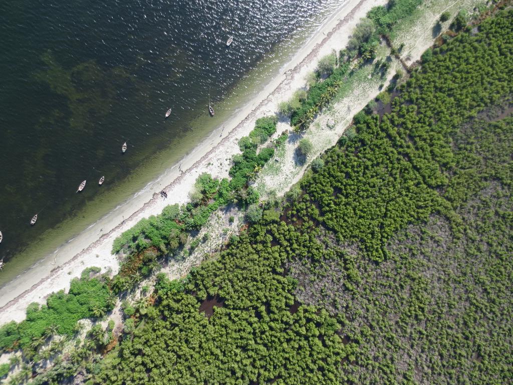
4 TITRE DE LA SLIDE A brand new tool : the UAV (Unmanned Aerial Vehicle) UAV, what for? Take aerial images with high resolution (4-10 cm/pix) Create an accurate Digital Elevation Model (15-20 cm) Top vision - high resolution Various uses of UAVs : Natural hazards Disaster Risk Reduction (DRR) Inspection Topographic surveys of landfills Agriculture Mining / quarrying Environmental Management Hydrological analyzes Research and rescue missions Coastal surveillance Monitoring of hazardous areas or difficult to access Monitoring of refugee camps (IDP) DEM
 Canaan,")

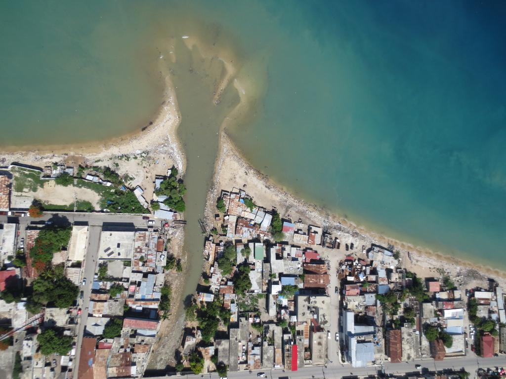
5 TITRE DE LA SLIDE A brand new tool : the UAV (Unmanned Aerial Vehicle) Canaan, November 2010 Time evolution Updated image The same area in June 2010 (5 months before)

 Lines levels")

6 TITRE DE LA SLIDE A new tool : the UAV (Unmanned Aerial Vehicle) Lines levels with 1 meter of resolution Digital Elevation Model (DEM)


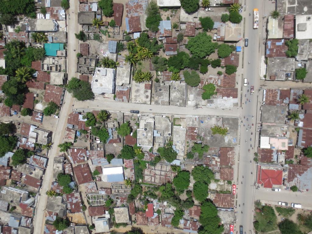
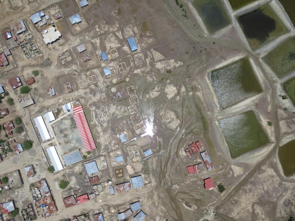
7 UAV for participatory mapping in Haiti UAV deployable for participatory mapping like OSM : Project with C.OSM.HA CartONG OSM Fr in May-June 2014 Bing satellite imagery UAV image
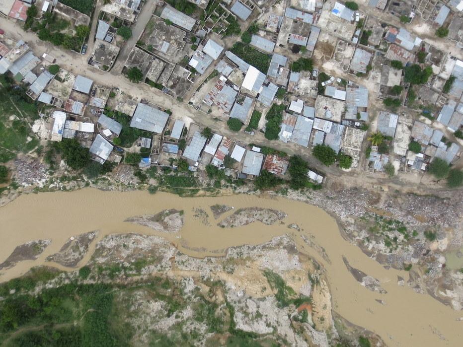
8 TITRE DE LA SLIDE Mission of May-June flights (70 sq km) with 3 communities : - 18 over PaP, Rivière Grise (30 sq km, 8 cm/pix) - 9 over St-Marc (14 sq km, 6-10 cm/pix) - 15 over North & Nort-East departments

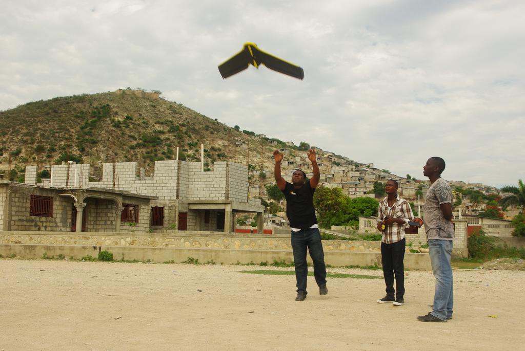
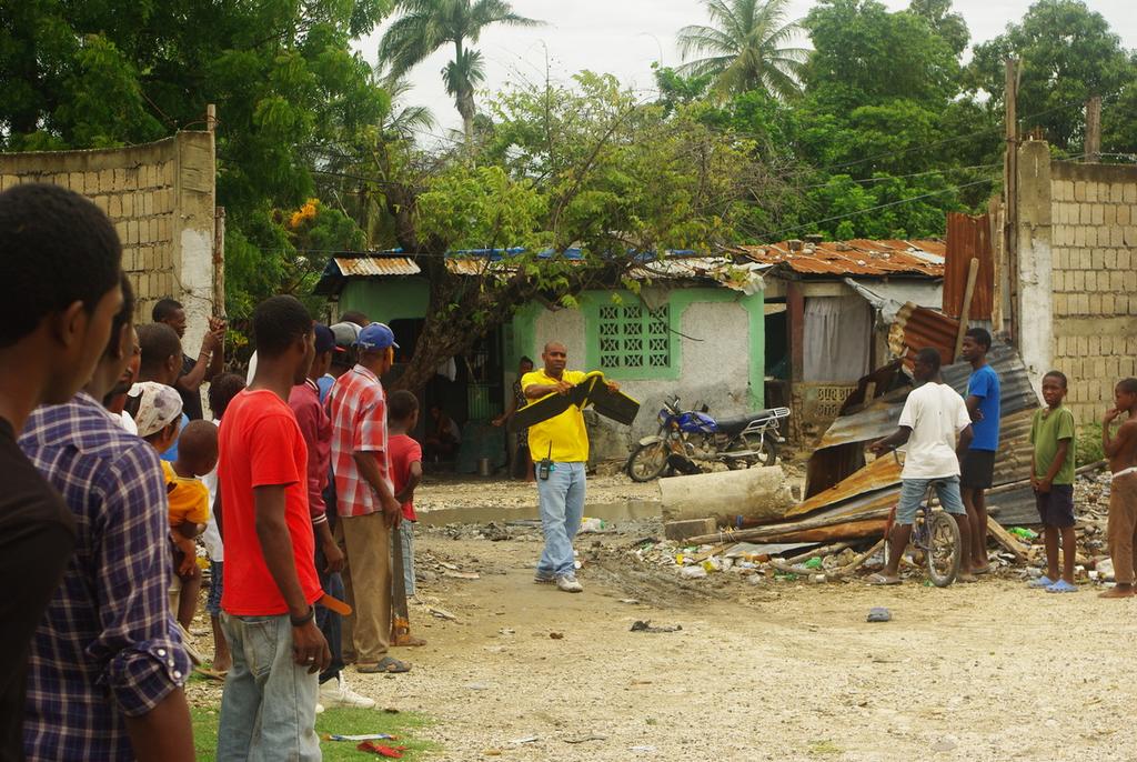
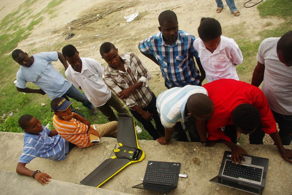
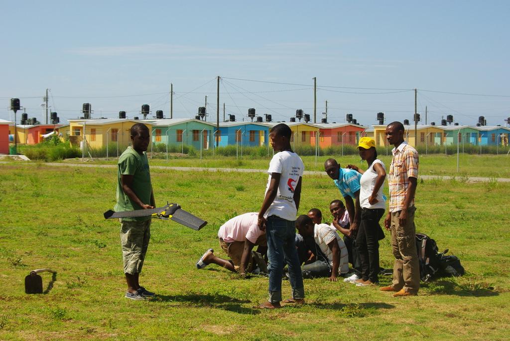
9 Some pictures

10 TITRE DE LA SLIDE Mission of May-June 2014 Knowing the territory : the first step to act for the communities Aerial imagery to uphold the field actors vision of the territory and to put the communities at the center UAV is a uniting tool that brings communities together Train the communities to map and use the UAV Participatory mapping makes possible to update geographic information and plan interventions together Participative mapping is a powerful tool to enhance the communities' resilience facing natural disasters, but also to engage a dynamic for the local development of the territory. It induces change from and with the local communities, despite difficulties 42 flights (70 sq km) with 3 communities : - 18 over PaP, Rivière Grise (30 sq km, 8 cm/pix) - 9 over St-Marc (14 sq km, 6-10 cm/pix) - 15 over North & Nort-East departments Salon des Soidarités Juin 2014


11 TITRE DE LA SLIDE Example of community work Cleaning of wastewater canals Soley Leve, quartier by quartier change on the ground, in Cité Soleil. Blocks organize to improve their own neighborhood. This map traces their progress,,,
12 UAV for participatory mapping in Haiti Some links : Communautary mapping/uav project in Haiti (Cartong) Using UAVs for Community Mapping and Disaster Risk Reduction in Haiti (irevolution) UAV participative mapping in Haiti - COSMHA / CartONG / OSM (video project) UAV-HAITI (Wiki OpenStreetMap) Using OSM for community work (konbit) ; example of Soley Leve Mapping & Aerial image OpenStreetMap Haiti (Map of UAV s activity in Haiti)


13 Thank You CartONG : +33 (0)
14 TITRE DE LA SLIDE Appendix #1 Main features of «ebee» UAV 2 functions : Aerial image high resolution (4-10 cm/pix) Accurate Digital Elevation Model (15-20 cm) Flights supervised and secured by remote control with computer Manual take-off Battery life of 30 min : o 1 sq km of coverage with 4 cm / pix (altitude of 130 m) o 2 sq km of coverage with 8 cm / pix (altitude of 260 m) Wind resistant up to 12 m/s (45 km/h) Lightweight (700g), no crash risk (security) Range up to 3 km, depending of the field Easy to use, although requires a minimal experience
15 TITRE DE LA SLIDE Appendix #2 Technical strenghts and weaknesses of the UAV Strenghts : Quick intervention, even on cloudy days Response to specific requests Setting of the flight characteristics Ability to change the flight plan during a mission Automated post-processing to build DEM & mosaic picture Weaknesses : Superficy cover restricted Wind < 12 m/s Landing fragilised Not static more suitable for imagery than video
GEO-7851 USING UAVS TO INCREASE PRODUCTIVITY AND SAFETY IN THE CONSTRUCTION INDUSTRY. Emmanuel de Maistre
 GEO-7851 USING UAVS TO INCREASE PRODUCTIVITY AND SAFETY IN THE CONSTRUCTION INDUSTRY Emmanuel de Maistre Better data. Better decisions. Using UAVs to increase productivity and safety in the construction
DRONE & UAV.
 www.erapkorea.co.kr DRONE & UAV Extended flight time Proven to be reliable, safe and easy to use Various fields of operation Completely autonomous, and manually controlled ERAP DRONE & UAV WHY ERAP s MAPPING
In 2003, A-Level Aerosystems (ZALA AERO) was founded by current company President Alexander Zakharov, since then he has led
 was founded by current company President Alexander Zakharov, since then he has led") A-Level Aerosystems In 2003, A-Level Aerosystems (ZALA AERO) was founded by current company President Alexander Zakharov, since then he has led the company to be a leader in the micro UAV market in Russian
A-Level Aerosystems In 2003, A-Level Aerosystems (ZALA AERO) was founded by current company President Alexander Zakharov, since then he has led the company to be a leader in the micro UAV market in Russian
THE FALCON REDUNDANCY HIGH WIND TOLERANCE BEST USED FOR SURVEILLANCE & SECURITY DELIVERY & TRANSPORT
 THE FALCON REDUNDANCY HIGH WIND TOLERANCE The Falcon's new air frame and motor configuration is the new best in its class of light payloads with flight times of up to 50 minutes. This makes the Falcon
Fire Fighting Equipment Development - Unmanned Aerial Vehicle Trials. Ripley Valley Rural Fire Brigade - August 2010
 Fire Fighting Equipment Development - Unmanned Aerial Vehicle Trials Ripley Valley Rural Fire Brigade - August 2010 The Brigade offered to help evaluate the capabilities of an Unmanned Aerial Vehicle (UAV)
SURVEYOR-H. Technical Data. Max speed 120 km/h. Engine power 7.2 hp. Powerplant Modified Zenoah G29E. Fuel tank volume 3.6 l
 rev. 28.10.14 * features & specifications are subject to change without notice. Technical Data Max speed 120 km/h Engine power 7.2 hp Powerplant Modified Zenoah G29E Fuel tank volume 3.6 l Payload with
Design and Navigation of Flying Robots
 Design and Navigation of Flying Robots Roland Siegwart, ETH Zurich www.asl.ethz.ch Drones: From Technology to Policy, Security to Ethics 30 January 2015, ETH Zurich Roland Siegwart 06.11.2014 1 ASL ETH
BY HOEYCOMB AEROSPACE TECHNOLOGIES. HC-330 HYBRID-POWERED ALL- ELECTRICITY DRIVEN four-rotor UAV
 BY HOEYCOMB AEROSPACE TECHNOLOGIES HC-330 HYBRID-POWERED ALL- ELECTRICITY DRIVEN four-rotor UAV Content SYSTEM SPECIFICATI- ON TYPICAL USING PROCESS OVERVIEW SUBSYSTEM SPECIFICATI- ON 1 OVERVIEW System
THE ULTIMATE DRONE SOLUTION
 THE ULTIMATE DRONE SOLUTION LX-1 ECHELON LiDAR MULTIROTOR Brochure & Technical Specifications OVERVIEW The LX-1 Echelon is a professional-grade hexacopter equipped with a LiDAR sensing payload, and designed
Building Efficiency of UAV Image Processing for ASEAN Countries - THAILAND. August 21-25, 2017 Space Krenovation Park, Chonburi, Thailand
 Building Efficiency of UAV Image Processing for ASEAN Countries - THAILAND August 21-25, 2017 Space Krenovation Park, Chonburi, Thailand Participants from Thailand Sarun Apichontrakul Jaturong Som-ard
FLYEYE Unmanned Aerial System
 FLYEYE Unmanned Aerial System FLYEYE Unmanned Aerial System About Flytronic FLYTRONIC is a dynamic modern engineering company focussed on developing Unmanned Aerial Systems to provide observation and reconnaissance
suas in CAP Delaware Wing HQ, Civil Air Patrol Development of small Unmanned Aerial Systems
 Delaware Wing HQ, Civil Air Patrol suas in CAP Development of small Unmanned Aerial Systems Advent of the suas Small Unmanned Aerial Systems have become very common recently Sophisticated microprocessors
DSSI UAV. Unmanned Aerial Vehicle. Research & Development Project
 UAV Unmanned Aerial Vehicle HISTORY AND SKILLS of Small UAV with electrically powered propeller Description of the solution: Airframe,electronics, 2 battery sets 1 spare Airframe, battery charger Transport
Design and Simulation of New Versions of Tube Launched UAV
 21st International Congress on Modelling and Simulation, Gold Coast, Australia, 29 Nov to 4 Dec 2015 www.mssanz.org.au/modsim2015 Design and Simulation of New Versions of Tube Launched UAV Y. Zhou and
Table of Contents. Abstract... Pg. (2) Project Description... Pg. (2) Design and Performance... Pg. (3) OOM Block Diagram Figure 1... Pg.
 Project Description... Pg. (2) Design and Performance... Pg. (3) OOM Block Diagram Figure 1... Pg.") March 5, 2015 0 P a g e Table of Contents Abstract... Pg. (2) Project Description... Pg. (2) Design and Performance... Pg. (3) OOM Block Diagram Figure 1... Pg. (4) OOM Payload Concept Model Figure 2...
March 5, 2015 0 P a g e Table of Contents Abstract... Pg. (2) Project Description... Pg. (2) Design and Performance... Pg. (3) OOM Block Diagram Figure 1... Pg. (4) OOM Payload Concept Model Figure 2...
UAV Drones. Team RamRod: Tyler Barry James Bohn Daniel Ramirez Hari Shrestha Arlo Swanson Garret Wilbanks
 UAV Drones Team RamRod: Tyler Barry James Bohn Daniel Ramirez Hari Shrestha Arlo Swanson Garret Wilbanks Outline Introduction History Technology and Applications Current Future Economics and Marketability
WingtraOne Technical Specifications
 WingtraOne Technical Specifications wingtra.com The all-in-one drone: large coverage, high resolution and accuracy WingtraOne Resolution Accuracy Coverage down to 0.7 cm/px (0.3 in/px) GSD down to 1 cm
Content. Introduction. Technology. Type of unmanned vehicle. Past, Present, Future. Conclusion
 Introduction Content Technology Type of unmanned vehicle Past, Present, Future Conclusion What is unmanned vehicles? l Without a person on board l Remote controlled l Remote guided vehicles Reduce casualty
UAV Systems Comparison. Planes, Frames and Autopilots
 UAV Systems Comparison Planes, Frames and Autopilots Presenter: Robert Lefebvre BASc Mechanical Engineering, University of Ottawa Managing Director NOVAerial Robotics Inc. Ardupilot Developer 6 Years UAV
Innovating the future of disaster relief
 Innovating the future of disaster relief American Helicopter Society International 33rd Annual Student Design Competition Graduate Student Team Submission VEHICLE OVERVIEW FOUR VIEW DRAWING INTERNAL COMPONENTS
We are for your safety
 EIMS CALENDAR 2017 We are for your safety ENVIRONMENT DIVISION DEM for proposed 200MW Solar Power Plant in Teknaf Study Area of Brahmaputra River Basin DEM of the Brahmaputra River Basin January New Year's
Analysts/Fund Managers Visit 19 April Autonomous Systems and Future Capability Mark Kane
 Analysts/Fund Managers Visit 19 April 2007 Autonomous Systems and Future Capability Mark Kane The Rationale for UAVs The Rationale for UAVs UAVs generally seen to carry out the dull, dirty, and dangerous
Damage Mapping of April 2015 Nepal Earthquake using Small UAV
 Final Workshop on J-RAPID-Nepal June 21-22, 2016, Kathmandu Damage Mapping of April 2015 Nepal Earthquake using Small UAV Hiroshi Inoue *1, Tsuneo Ohsumi *1, Hiromichi Fukui *2, Ramesh Guragain *3, Gopi
The requirements for unmanned aircraft operating in oil, gas and mineral exploration and production
 AUVSI Unmanned Systems North America 2013 Conference August 14, 2013 The requirements for unmanned aircraft operating in oil, gas and mineral exploration and production Dr Joseph Barnard joseph.barnard@barnardmicrosystems.com
Ejemplos de aeronaves existentes similares a las propuestas en los RFP 2007
 Ejemplos de aeronaves existentes similares a las propuestas en los RFP 2007 UAV Sergio Esteban sesteban@us.es 1 Advanced Technologies and Engineering Co (Pty) Ltd (ATE). Vulture Production: Production
Marine Robotics. Alfredo Martins. Unmanned Autonomous Vehicles in Air Land and Sea Politecnico Milano June 2016
 Marine Robotics Unmanned Autonomous Vehicles in Air Land and Sea Politecnico Milano June 2016 INESC TEC / ISEP Portugal alfredo.martins@inesctec.pt Multiple autonomous vehicles at sea 2 Multiple coordinated
SPECIAL MISSION AIRCRAFT
 SPECIAL MISSION AIRCRAFT precision from above FACTS AND SPECIFICATIONS DA42 MPP Guardian - Facts and Specifications Power plant Engine Propeller Fuel grades 2x AUSTRO ENGINE AE300 (168 hp, turbo charged)
In recent years, multirotor helicopter type autonomous UAVs are being used for aerial photography and aerial survey. In addition, various
 25 6 18 In recent years, multirotor helicopter type autonomous UAVs are being used for aerial photography and aerial survey. In addition, various applications such as buildings maintenance, security and
Austrian Show Case Disaster Relief. Diamond Aircraft, Hanoi February DAI-Marketing/Mandl
 Austrian Show Case Disaster Relief Diamond Aircraft, Hanoi 20 21 February 2012 Multiple requirements Multi Purpose Platform 1. Company Movie 2. Company presentation 3. Disaster relief 4. Security 5. One-stop
DEVELOPMENT OF INFRASTRUCTURE-BASED AUTONOMOUS DRIVING SUPPORT SYSTEM USING DYNAMIC MAPS
 24th Annual ITS World Congress 2017 TS72 : Traffic Management Case Studies 01 November 2017 DEVELOPMENT OF INFRASTRUCTURE-BASED AUTONOMOUS DRIVING SUPPORT SYSTEM USING DYNAMIC MAPS Yoshiaki Tsuda +), Keisuke
CORINE Title Land Cover. First name SURNAME György BÜTTNER Position Senior advisor
 CORINE Title Land Cover First name SURNAME György BÜTTNER Position Senior advisor Name EEA/ IDM4 of the entity Place, Copenhagen, date 19/10/2015 Outline CLC basics Geographic coverage of CLC2012 Methodology
komatsu.com.au komatsu.co.nz /KomatsuAustralia/
 INNOVATIVE INTELLIGENT INTEGRATED komatsu.com.au komatsu.co.nz /KomatsuAustralia/ intelligent MACHINE CONTROL Introducing intelligent Machine Control Komatsu s innovative intelligent Machine Control (imc)
Small UAV A French MoD perspective and planning
 Small UAV A French MoD perspective and planning French ISTAR segmentation portable transportable infrastructure System volume Tactical Small UAV Contact Combat Helicopters (MTI) Fighter Aircrafts Land
Monitoring Bank Erosion On the Missouri River, Lower Brule Reservation
 Monitoring Bank Erosion On the Missouri River, Lower Brule Reservation A cooperative study between the Lower Brule Sioux Tribe s Environmental Protection Office and the U.S. Geological Survey, with assistance
Unmanned Surface Vessels - Opportunities and Technology
 Polarconference 2016 DTU 1-2 Nov 2016 Unmanned Surface Vessels - Opportunities and Technology Mogens Blanke DTU Professor of Automation and Control, DTU-Elektro Adjunct Professor at AMOS Center of Excellence,
INSTYTUT TECHNICZNY WOJSK LOTNICZYCH Air Force Institute of Technology
 1953-2014 INSTYTUT TECHNICZNY WOJSK LOTNICZYCH Air Force Institute of Technology 01 Aircraft Engines Division Airworthiness Division IT Logistics Support Systems Division Aeroplanes & Helicopters Division
Hawaii Fire Risk Mapping Project
 HIGICC Conference September 24, 2009 Hawaii Fire Risk Mapping Project Rich Nezelek, Sr. Imagery Analyst Chris Chiesa, Chief Information Officer Pacific Disaster Center www.pdc.org Presentation Overview
Supplemental Historical Background for Lake Sangraco and the Kershaw Ditch, Adams County, Colorado
 Supplemental Historical Background for Lake Sangraco and the Kershaw Ditch, Prepared for: Regional Transportation District 1560 Broadway, Suite 700 Denver, Colorado 80202 303-299-2426 Prepared by: Thomas
Prototyping Collision Avoidance for suas
 Prototyping Collision Avoidance for Michael P. Owen 5 December 2017 Sponsor: Neal Suchy, FAA AJM-233 DISTRIBUTION STATEMENT A: Approved for public release; distribution is unlimited. Trends in Unmanned
UAV Magnetometry for Mineral Exploration
 UAV Magnetometry for Mineral Exploration Case Study: Île Calumet, QC JC Ricard, CEO Devbrio Géophysique C. Mercier, Jr. Eng. J. Blanchard, M.Sc. Geophysics Devbrio UAV magnetometer 1 Developed by Devbrio
Deliverable 3 Autonomous Flight Record
 Deliverable 3 Autonomous Flight Record 2012 UAV Outback Challenge Search and Rescue Challenge www.canberrauav.com Proudly Sponsored by: Paul Tridgell Terry Porter Grant Morphett Ron Graham Page 1 of 11
ARCHIVED REPORT. For data and forecasts on current programs please visit or call
 Radar Forecast ARCHIVED REPORT For data and forecasts on current programs please visit www.forecastinternational.com or call +1 203.426.0800 Outlook ZPQ-1 is being replaced on newer UAVs with more modern
MAV and UAV Research at Rochester Institute of Technology. Rochester Institute of Technology
 MAV and UAV Research at Andrew Streett 5 th year BS/MS Student 2005-2006 MAV Team Lead Jason Grow BS/MS Graduate of RIT 2003-2004 MAV Team Lead Boeing Phantom Works, HB 714-372-9026 jason.a.grow@boeing.com
4.5 HOURS ENDURANCE 21 KG MAX. TAKE-OFF WEIGHT IP-56 WATER/DUST RESISTANT FULLY AUTOMATIC 5 KG PAYLOAD IMC-SHIELDED +50 KM RANGE WITH HD VIDEO
 HEF32 UAV System 4.5 HOURS ENDURANCE 21 KG MAX. TAKE-OFF WEIGHT IP-56 WATER/DUST RESISTANT FULLY AUTOMATIC 5 KG PAYLOAD IMC-SHIELDED +50 KM RANGE WITH HD VIDEO CERTIFIED OPERATIONS MANUAL PART 145 MAINTENANCE
Tactical Technology Office. Tactical Technology Office. Programs. DARPATech 2000 Dr. David Whelan Director Whelan Darpatech
 Programs DARPATech 2000 Dr. David Whelan Director dwhelan@darpa.mil Global Surveillance Land Systems Aerospace Systems Embedded Processing & Control Global Surveillance Objectives: Birth-to-Death Track
Supplementary Information for Optimal Altitude, Overlap, and Weather Conditions for Computer Vision UAV Estimates of Forest Structure Remote Sensing
 Supplementary Information for Optimal Altitude, Overlap, and Weather Conditions for Computer Vision UAV Estimates of Forest Structure Remote Sensing 2015, 7, 13895 13920 Table S1. List of UAV flight configurations
Using ground based high resolution photography for seasonal snow and ice dynamics (Austre Lovénbreen, Svalbard, 79 N)
") Using ground based high resolution photography for seasonal snow and ice dynamics (Austre Lovénbreen, Svalbard, 79 N) 1 BERNARD E., 2 FRIEDT J. M., 1 TOLLE F., 3 MARLIN Ch., 1 GRISELIN M. 1 CNRS UMR ThéMA,
Using ground based high resolution photography for seasonal snow and ice dynamics (Austre Lovénbreen, Svalbard, 79 N) 1 BERNARD E., 2 FRIEDT J. M., 1 TOLLE F., 3 MARLIN Ch., 1 GRISELIN M. 1 CNRS UMR ThéMA,
AEM 4321 / EE4231 Automatic Control Systems
 AEM 4321 / EE4231 Automatic Control Systems Course Overview 1/31 Outline Course Objectives Applications of Control Examples: Cruise Control and Aircraft Autopilots Terminology Block Diagrams Summary 2/31
PENGUIN C UAS OPERATIONS & MAINTENANCE TRAINING 20 HOURS FLIGHT ENDURANCE 100KM RANGE ITAR - FREE CREW OF TWO
 PENGUIN C UAS LONG ENDURANCE UNMANNED AERIAL SYSTEM 20 HOURS FLIGHT ENDURANCE OPERATIONS & MAINTENANCE TRAINING 100KM RANGE ITAR - FREE CREW OF TWO U AV FAC T O RY LT D., E U R O P E U AV FAC T O RY U
Mars Surface Mobility Proposal
 Mars Surface Mobility Proposal Jeremy Chavez Ryan Green William Mullins Rachel Rodriguez ME 4370 Design I October 29, 2001 Background and Problem Statement In the 1960s, the United States was consumed
9/11/2018. UAS110 Intro to UAV Systems. UAS110 Intro to Unmanned Aerial Systems. Overview. Impetus. 3: UAV Classification
 UAS110 Intro to Unmanned Aerial Systems 2018 J. Sumey California University of PA rev. 9/11/18 Overview UAVs may be classified according to various metrics scale (size) method of lift generation range/endurance
Republic of Korea Airworthiness Certification of Unmanned Aerial System
 Republic of Korea Airworthiness Certification of Unmanned Aerial System Name : Maj. Na, Kyeong-min(ROK), Hwang, Ki-Lyong(KAL) E-mail : kminn@korea.kr, klhwang@koreanair.com Contents PART I Introduction
Palos Verdes High School 1
 Abstract: The Palos Verdes High School Institute of Technology (PVIT) Unmanned Aerial Vehicle team is proud to present Condor. Condor is a hexacopter weighing in at 1664g including the 4 cell 11.1 volt,
Investigative Technologies and Techniques
 Investigative Technologies and Techniques Using Drones In Accident Investigation (Aerial Photography) Drone used in accident investigation Technical specifications and performance Flat 8 motor configuration
Aeronautical Systems Center
 Aeronautical Systems Center Global Hawk Program Overview Michael Johnston 303 AESG/LG DSN: 787-4047 Comm: 937-255-4047 michael.johnston@wpafb.af.mil RQ-4A Global Hawk System Global Hawk: High-altitude,
Cooperative EVA/Telerobotic Surface Operations in Support of Exploration Science
 Cooperative EVA/Telerobotic Surface Operations in Support of Exploration Science David L. Akin http://www.ssl.umd.edu Planetary Surface Robotics EVA support and autonomous operations at all physical scales
MA THOR SolarLight UAS
 Marques Aviation Ltd Advanced-technology Hybrid Propulsion Air Platform Advanced-technology innovative air platform project that supersedes the capabilities of the majority of MALE UAVs. Hybrid solar-electric-hydrogen
Release Enhancements GXP Xplorer GXP WebView
 Release Enhancements GXP Xplorer GXP WebView GXP InMotionTM v2.3.4 An unrivaled capacity for discovery, exploitation, and dissemination of mission critical geospatial and temporal data The v2.3.4 release
Eye In The Sky: The Future of Risk Assessment From Above
 Eye In The Sky: The Future of Risk Assessment From Above Property Insurance Report National Conference 15 November 2010 Timothy E. Carone, Ph.D. Director, Global Climate Monitoring Systems Advanced Programs
SMART ROAD. The innovative road that runs with progress
 SMART ROAD The innovative road that runs with progress What is a Smart Road? SAFETY COMFORT CONNECTIVITY INFORMATION 2 Smart Road ANAS Anas has launched the Smart Road programme ~ 3000 km The project concerns
IST Sounding Rocket Momo User Guide
 2 Table of contents Revision History Note 1.Introduction 1 1.Project Overview 1 2. About the Momo Sounding Rocket 1 3.Launch Facility 2.Mission Planning Guide 2 1. Flight stages 2 2. Visibility from the
Masts, telescopic and sectional
 Masts, telescopic and sectional Communication Masts Sectional composite masts for manportable applications up to 9 metres Telescopic push-up masts up to 10 metres Telescopic aluminium, composite & carbon
Development of a Low Cost DIY UAV Mapping Platform
 Development of a Low Cost DIY UAV Mapping Platform James Parkes Tritan Survey CC, Engineering and Hydrographic Surveyors, Cape Town, South Africa +27 21 797 2081 - jamesp@tritan.co.za Abstract In the past
VEDECOM. Institute for Energy Transition. Prénom - Nom - Titre. version
 VEDECOM Institute for Energy Transition Prénom - Nom - Titre version VEDECOM: COLLABORATIVE RESEARCH HUB 2 Foundation of the Université de Versailles Saint-Quentin-en-Yvelines (UVSQ) Certified as Institute
Oil on Water Exercise 2017 Sarah Hall, Development & Assurance Advisor for Surveillance, Modelling and Visualisation (SMV)
") Oil on Water Exercise 2017 Sarah Hall, Development & Assurance Advisor for Surveillance, Modelling and Visualisation (SMV) Copyright 2017. Oil Spill Response Limited. Content Why an oil on water exercise?
Oil on Water Exercise 2017 Sarah Hall, Development & Assurance Advisor for Surveillance, Modelling and Visualisation (SMV) Copyright 2017. Oil Spill Response Limited. Content Why an oil on water exercise?
REPORT A-008/2008 DATA SUMMARY
 REPORT A-008/2008 DATA SUMMARY LOCATION Date and time Wednesday, 5 March 2008; 08:25 local time 1 Site Yaiza (Island of Lanzarote) AIRCRAFT Registration Type and model EC-FJV AEROSPATIALE AS-350B2 Operator
UAVs UK - factsheet. The Variants. Desert Hawk
 FS 70 UAVs UK - factsheet The Variants Desert Hawk Battery powered and hand launched. Can fly for around one hour at 200-800 feet within a 15km radius of its ground control system. Used for battlefield
Challenges facing the satellite community. Vice President, Spectrum Management & Development Americas SES
 Challenges facing the satellite community November 2, 2012 Kimberly Baum Vice President, Spectrum Management & Development Americas SES Agenda This presentation will look to the past (WRC-03, WRC-07 &
Open & Evolutive UAV Architecture
 Open & Evolutive UAV Architecture 13th June UAV 2002 CEFIF 16-juin-02 Diapositive N 1 / 000 Report Documentation Page Form Approved OMB No. 0704-0188 Public reporting burden for the collection of information
Data acquisition within T-AI DSS
 Data acquisition within T-AI DSS Tamara Ivelja 1, Ivan Racetin¹, Andrija Krtalic¹ Abstract The module of T-AI DSS for data acquisition should provide the stability and reliability of (aerial) data acquisition
THE AIRCRAFT FLEET. UV 18-A Twin Otter (2) Pelican (2) Sentry BK 30 UAV (5) SPA-10
 Pelican (2) Sentry BK 30 UAV (5) SPA-10") THE AIRCRAFT FLEET UV 18-A Twin Otter (2) Pelican (2) Sentry BK 30 UAV (5) SPA-10 Marina Facility 3500 ft runway - manned operations only 30,000 sq ft maintenance hangar Instrumentation and Calibration
THE AIRCRAFT FLEET UV 18-A Twin Otter (2) Pelican (2) Sentry BK 30 UAV (5) SPA-10 Marina Facility 3500 ft runway - manned operations only 30,000 sq ft maintenance hangar Instrumentation and Calibration
Lockheed Martin. Team IDK Seung Soo Lee Ray Hernandez Chunyu PengHarshal Agarkar
 Lockheed Martin Team IDK Seung Soo Lee Ray Hernandez Chunyu PengHarshal Agarkar Abstract Lockheed Martin has developed several different kinds of unmanned aerial vehicles that undergo harsh forces when
FLYING CAR NANODEGREE SYLLABUS
 FLYING CAR NANODEGREE SYLLABUS Term 1: Aerial Robotics 2 Course 1: Introduction 2 Course 2: Planning 2 Course 3: Control 3 Course 4: Estimation 3 Term 2: Intelligent Air Systems 4 Course 5: Flying Cars
SHRP 2 RID. Roadway Information Database
 SHRP 2 RID Roadway Information Database Research Team CTRE/Iowa State University: Omar Smadi Neal Hawkins Zach Hans Basak Bektas Nick Burdine Cambridge Systematics: Bruce Spear Kevin Howard Goal Design,
French National electro-mobility association Joseph Beretta Business opportunity and challenges
 French National electro-mobility association Joseph Beretta Business opportunity and challenges The Association history: After the first oil shock, the question of the independence of mobility to fossil
For Missions Accomplished. Whatever the missions, whatever the times, wherever the places, we ll get you where you re going.
 For Missions Accomplished Whatever the missions, whatever the times, wherever the places, we ll get you where you re going. A Swiss Made Helicopter Kopter Group was founded for the purpose of developing,
Airport Report on Regional Air Service Efforts & UAV Test Site Designation. January 21, 2015 Elko County Commission
 Airport Report on Regional Air Service Efforts & UAV Test Site Designation January 21, 2015 Elko County Commission PRESENTATION ADDRESSING 1. Small Airport s without EAS Are at a High Risk to Lose Air
Latest technology in specialty crop production. Good coverage + ~ 0 drift
 Latest technology in specialty crop production Good coverage + ~ 0 drift Unmanned Aircraft for Agricultural Spraying of Specialty Crops Ken Giles Ryan Billing UC-Davis Biological & Agricultural Engineering
SeaRobotics Facility. Integrated Facility for the Design and Build and Test. Location. Facility. Test Capability
 1 SeaRobotics Facility Location Located in Stuart, Florida 26 miles north of Riviera Beach ¼ mile from I-95 Facility 1400 square meters in Treasure Coast Commerce Park 400 m2, Engineering, Integration
UNMANNED AIR VEHICLE ( UAV ) USE IN THE MUNICIPAL GOVERNMENT ENVIRONMENT RECOMMENDATION
 USE IN THE MUNICIPAL GOVERNMENT ENVIRONMENT RECOMMENDATION") TO: FROM: CHAIR AND MEMBERS CIVIC WORKS COMMITTEE MEETING ON SEPTEMBER 7, 2016 JOHN BRAAM, P.ENG. MANAGING DIRECTOR, ENVIRONMENTAL & ENGINEERING SERVICES AND CITY ENGINEER SUBJECT: UNMANNED AIR VEHICLE
TO: FROM: CHAIR AND MEMBERS CIVIC WORKS COMMITTEE MEETING ON SEPTEMBER 7, 2016 JOHN BRAAM, P.ENG. MANAGING DIRECTOR, ENVIRONMENTAL & ENGINEERING SERVICES AND CITY ENGINEER SUBJECT: UNMANNED AIR VEHICLE
ISSUE Construction and ROV Professionals Q2 / A Breakthrough in Hybrid Underwater Vehicles. The ECA Mine Counter Measure System
 8. A Breakthrough in Hybrid Underwater Vehicles 25. The ECA Mine Counter Measure System 31. The SeaTrepid Story 34. The Evolution of Single Beam Sonars for ROVs 11 The magazine of choice for Subsea ISSUE
Camera Drones Lecture 5 Regulations for camera drones in Austria
 Camera Drones Lecture 5 Regulations for camera drones in Austria Ass.Prof. Friedrich Fraundorfer WS 2017 1 Outline Categories and Permits No-Fly zones Toy planes Example cases 2 Regulations in Austria
ITS deployment for connected vehicles and people
 Session 1: Global ITS update ITS deployment for connected vehicles and people June 27, 2013 Hajime AMANO President, ITS Japan 2 CACS(1973~1979) CACS: The Comprehensive Automobile Traffic Control System
Study Report. McCredie-Overton Transmission Line Right-of-Way Analysis. City of Columbia, Missouri. prepared for the (S49)
") Study Report McCredie-Overton Transmission Line Right-of-Way Analysis prepared for the City of Columbia, Missouri (S49) May, 2017 S49 McCredie-Overton Transmission Line Right-of-Way Study Report Table
Study Report McCredie-Overton Transmission Line Right-of-Way Analysis prepared for the City of Columbia, Missouri (S49) May, 2017 S49 McCredie-Overton Transmission Line Right-of-Way Study Report Table
Yulia Zarayskaya Rochelle Wigley
 for the On behalf of the GEBCO-NF Alumni Team Yulia Zarayskaya geozar@yandex.ru Geological Institute RAS Rochelle Wigley rochelle@ccom.unh.edu Center for Coastal and Ocean Mapping Non-profit organization
UAV KF-1 helicopter. CopterCam UAV KF-1 helicopter specification
 UAV KF-1 helicopter The provided helicopter is a self-stabilizing unmanned mini-helicopter that can be used as an aerial platform for several applications, such as aerial filming, photography, surveillance,
'Prototype' Commission Regulation on Unmanned Aircraft Operations. FAI proposal for model flying activities
 Lausanne, 17 January 2017 'Prototype' Commission Regulation on Unmanned Aircraft Operations FAI proposal for model flying activities Annexes: 1- Article 15 - Provisions for model aircraft operations 2-
European Workshop on Aircraft Design Education 2002
 From Specification & Design Layout to Control Law Development for Unmanned Aerial Vehicles Lessons Learned from Past Experience Zdobyslaw Goraj WUT, Poland Philip Ransom, Paul Wagstaff Kingston University,
Human Factors of UAVs: Manning the Unmanned
 Human Factors of UAVs: Manning the Unmanned Opening Session Overview Welcome (0830-0840) Opening Remarks (0840-0900) The Operator s Perspective (0900-1000) Welcome! Introductions Logistics Opening Remarks
THE PERFECT MOBILE VSHORAD SOLUTION
 THE PERFECT MOBILE VSHORAD SOLUTION Ground Based Air Defence System Solutions Anders Linder, Head of Surface Radar Solutions Michael Höglund, Head of Marketing & Sales, Missile Systems This document and
Unmanned Air Vehicles (UAVs): Classification, Legislation and Future applications Presenter: Dr-Ing Dimitrios E. Mazarakos
: Classification, Legislation and Future applications Presenter: Dr-Ing Dimitrios E. Mazarakos") Unmanned Air Vehicles (UAVs): Classification, Legislation and Future applications Presenter: Dr-Ing Dimitrios E. Mazarakos The presenter Dr-Ing Dimitrios E. Mazarakos Dipl. in Mechanical Engineering and
Unmanned Air Vehicles (UAVs): Classification, Legislation and Future applications Presenter: Dr-Ing Dimitrios E. Mazarakos The presenter Dr-Ing Dimitrios E. Mazarakos Dipl. in Mechanical Engineering and
G4 RECON ONE Product overview and performance features
 G4 RECON ONE Product overview and performance features Today MULTIROTOR is one of the leading manufacturers of advanced UAV systems. In the field of geodesy the MULTIROTOR G4 has become one of the most
NATIONAL SPACE PROGRAM. February 10 th, 2016 Capua, ITALY
 NATIONAL SPACE PROGRAM February 10 th, 2016 Capua, ITALY The National Space Program Space Information Cycle (To go to space to see the Earth ) An opportunity for national technology development 2 The National
Intelligent Vehicle Systems Southwest Research Institute
 Intelligent Vehicle Systems Southwest Research Institute State-of-the-Art: Self Driving Cars (aka Automated Vehicles) Josh Johnson Assistant Director R&D Intelligent Systems 1 Motivation for This Presentation
EMERGENCY RESPONSE & EXPEDITIONARY SOLAR SAFETY LIGHTING PRODUCTS
 EMERGENCY RESPONSE & EXPEDITIONARY SOLAR SAFETY LIGHTING PRODUCTS AIRFIELDS BUILDING & ROADWAY OBSTRUCTION MARINE PERIMETER AND GENERAL AREA LIGHTING Choose solar-powered solutions for rapid deployment
Toyota s トヨタの安全への取り組み
 2016 Technology Media Trip Toyota s トヨタの安全への取り組み Safety Initiatives Toyota Motor Corporation Assistance Chief Safety Technology Office Seigo Kuzumaki 29 August, 2016 1 Transition of Traffic Accident Fatalities(Global)
Smart City/Smart Mobility Strategy. Hans Larsen, Fremont Public Works Director May 2, 2018
 Smart City/Smart Mobility Strategy Hans Larsen, Fremont Public Works Director May 2, 2018 About Fremont 230,000 Population; 4 th Largest City in Bay Area About Fremont #1 Happiest Place to Live in America
LOON LAKE HYDRO ACOUSTIC SURVEY RESULTS AND TREATMENT DATA 2012
 LOO LAKE HYDRO ACOUSTIC SURVEY RESULTS AD TREATMET DATA 212 632 W. Eastwood Drive Mequon, WI Hydro acoustics utilizes sound energy to detect objects and contours underwater. By integrating digital echo
First results and next steps in Kazakhstan Earth Observation missions in cooperation with SSTL
 First results and next steps in Kazakhstan Earth Observation missions in cooperation with SSTL M.Moldabekov (1), M.Nurguzhin (2), V.Ten (3), S.Murushkin (3), H.Lambert (3), A.da Silva Curiel (4), D.King
Introduction of Overseas Technologies to JR East Track Maintenance
 Introduction of Overseas Technologies to JR East Track Maintenance Katsumi Ise Introduction JR East makes great efforts in track maintenance to ensure stable transport, especially in the Tokyo capital