Monitoring Bank Erosion On the Missouri River, Lower Brule Reservation
|
|
|
- Christian Carson
- 6 years ago
- Views:
Transcription

1 Monitoring Bank Erosion On the Missouri River, Lower Brule Reservation A cooperative study between the Lower Brule Sioux Tribe s Environmental Protection Office and the U.S. Geological Survey, with assistance from the Oglala Lakota College. U.S. Department of the Interior U.S. Geological Survey

2 This study was designed to monitor the physical changes that occur along the Missouri River bank during the study s twoyear period, beginning Jan


3 Construction of the main stem dams on the Missouri River were completed under the Flood Control Act of Ft. Randall Dam Construction began in 1946 Completed in 1956 Formed Lake Francis Case Big Bend Dam Construction began in 1959 Completed in 1963 Formed Lake Sharpe The dams created reservoirs that flooded large areas and consumed forests, prairie, farms and communities.
 in the original Lower Brule community.")
4 Sonar picture of St. Mary s Church (top structure) in the original Lower Brule community. (courtesy of Lower Brule tribal personnel, summer 2012)


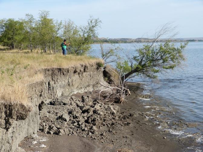
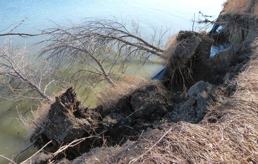
5 Cultural, historical, infrastructural, recreational and riparian areas have been lost to the Missouri River and the erosion continues today.


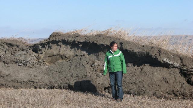
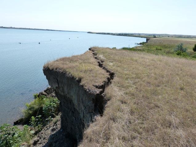
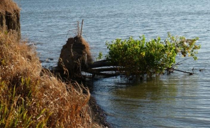

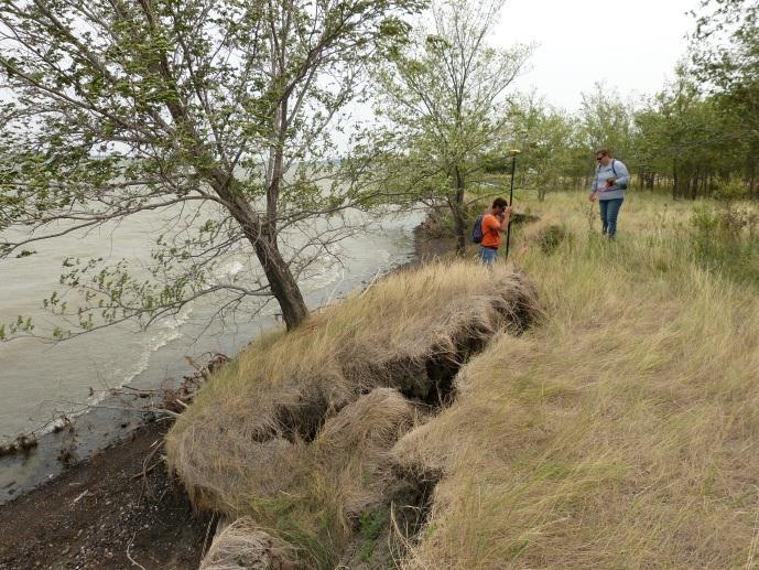
6 Bank erosion takes on many forms.

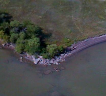
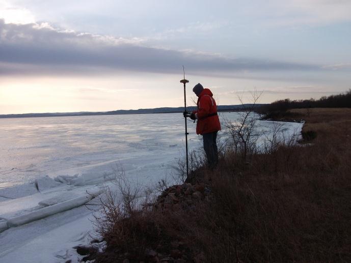
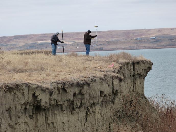
7 Seven-Mile Study Area
")


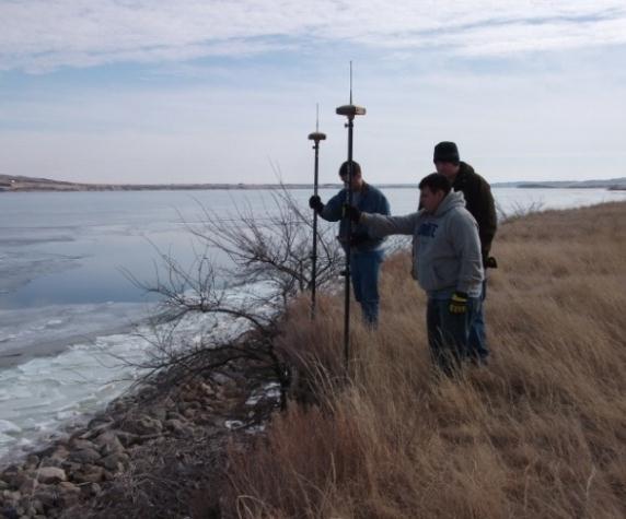
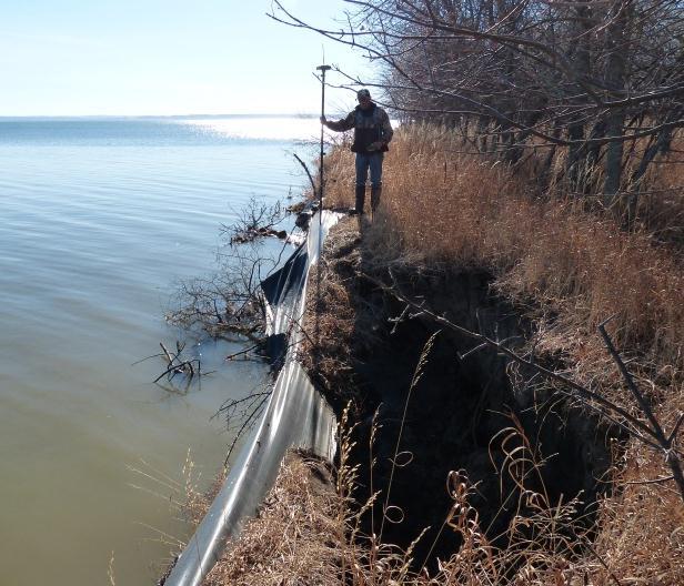
8 3 Types of Significant Digital Data: Light Detection And Ranging (LiDAR) measurements (in collaboration with Oglala Lakota College, Oglala Sioux Tribe, SD) Unmanned aerial system (UAS) to collect aerial photography (with assistance from the USGS UAS Project Office Rocky Mountain Geographic Science Center, Denver, CO) RTK measurements


9 LiDAR LiDAR was used to obtain precise land-surface elevation data at two locations in March, The LiDAR objective called for a comparison of the 2011 data to data collected in 2012, then to develop a measurement of the volume of soil that may have eroded.


10 LiDAR The Oglala Lakota College (OLC) is collaborating with the LBST & USGS on the LiDAR objective of this study, providing the LiDAR equipment and assisting with the collection and postprocessing. File version: 4 Temperature: Pressure: ppm: use ppm: 0 Time of the scan: Fri Feb 18 15:50: Scan 1 P HDS3000, Regular Scan Jim Sanovia, OLC Professor, has been working with us, and a student is also involved.


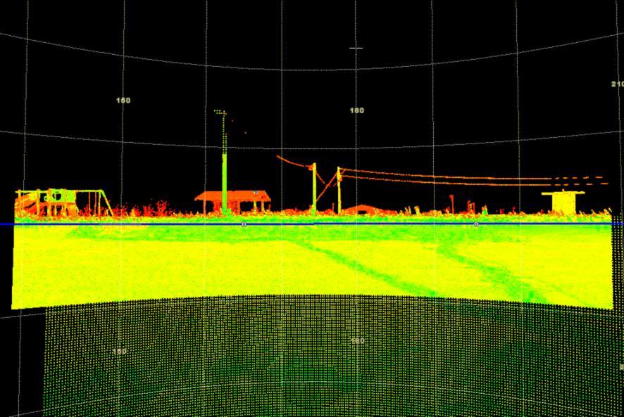
11 Examples of images collected during the LiDAR effort.
 the image created by")

 a")
12 Post-processing LiDAR Data Comparing: 1) a photo at the high-bank area to (2) the image created by one of the test LiDAR scans, (note the resolution from one meter on the far left to 0.3-meter resolution on the center & right), to (3) the point-cloud data imported to ArcGIS, to (4) a zoomed image.

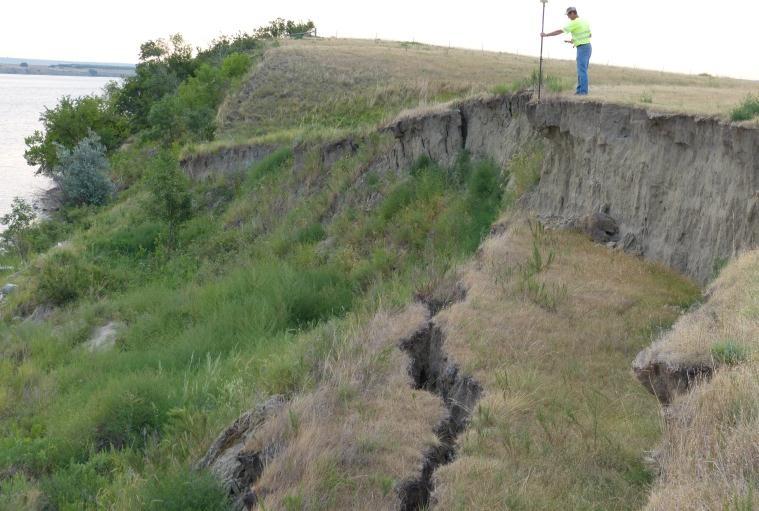
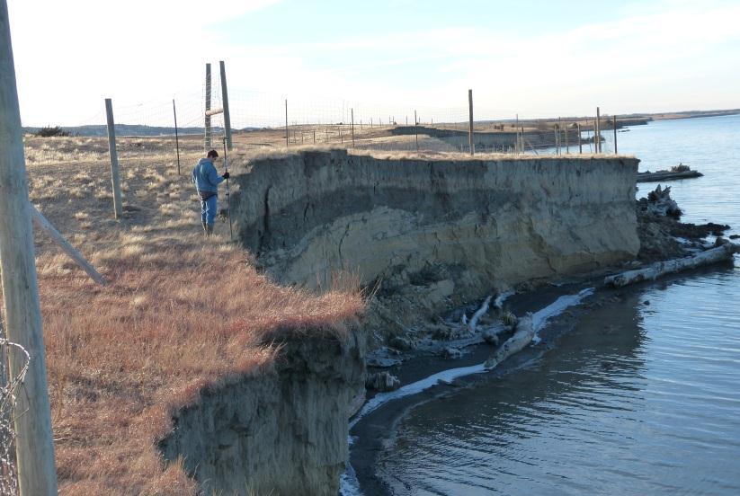
13 The 2012 effort could not be completed as the Winter of 2012 was extremely warm and there was insufficient safe ice. Thus we have extended the study s ending date to the end of April, 2013, allowing us to hopefully complete this effort in March of Update: During a May, 2012 site visit, we found we will definitely have a measureable loss of soil as we found we had lost our LiDAR tree to erosion).


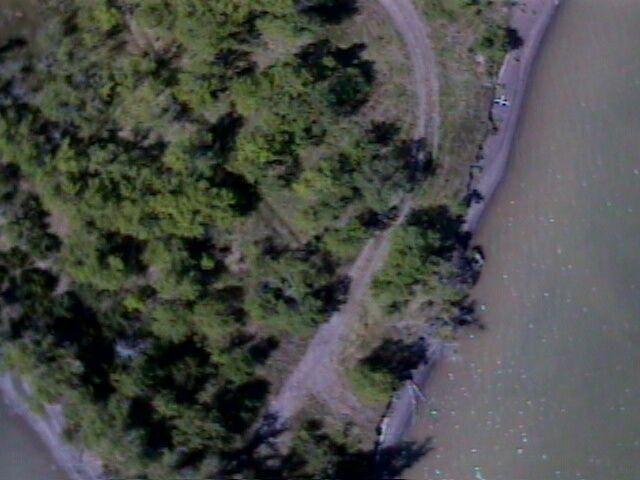
14 Unmanned Aerial System (UAS) Flights were conducted during August, 2011 and The small, unmanned aerial vehicle (UAV), used for this study was a Raven RQ-11A. The study s fly-zone includes a no-fly zone over Lower Brule. The flight path is along the shoreline.


15 The USGS Rocky Mountain UAS Project Office has provided support to guide us through the required FAA & military procedures and provide pilots. An additional proof-of-concept trial included the first boat launch, and the hand-off of control to a 2 nd pilot (located at the base tent).


16 Aerial targets are placed in strategic locations for the UAS flights. Target locations 2012


17 The laptop allows the mission controller to set flight points and view the UAS s location. The video window allows the controller to see to video that is being captured. Once the UAS is in the air, it can also be flown by the laptop only, by moving the flight points. Live-streaming was utilized in The Lower Brule High School Science Class interacted with USGS personnel.


18 Captures from IR camera looking at the lagoons: Black-hot and White-hot. Examples of electro-optical (EO) camera photos.
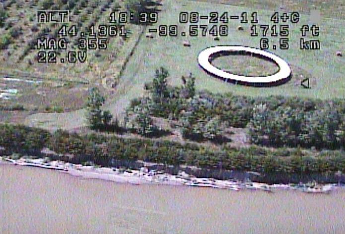

19 Example of still-pictures captured from the video. Example of data captured with each real-time picture saved.


20 Comparing Results of Annual Flights 2011 flights provided baseline data. This playground equipment is obviously in danger, but how long will it take to reach the bordering wood frame that is approx. 2 to 4 feet back? 2012 flights documented that the bank had eroded, allowing the front of the wood frame and surrounding soil to disappear during the year around this playground equipment.
, revealing the loss of shoreline in those")

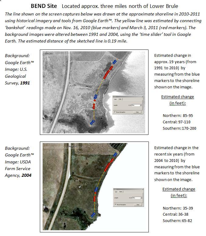
21 Comparing UAS Results With Other Types of Data The final product was then overlaid with the 2004 shoreline (illustrated from 2004 NAIP data), revealing the loss of shoreline in those six years. A technique called 'Rubber-Sheeting' was used to match the screen captures with the 2011 National Agriculture Imagery Program (NAIP) data by visually examining the photos & metadata.

22 The UAS Project Office is using a new software package to postprocess the 2012 data, allowing for faster and improved output.
23


 Fort")
24 Target Areas 3 sites were monitored on a quarterly basis. Seven-mile (the original, primary study area) Fort George Island
25

26 Results from the quarterly RTK monitoring were severe in many areas during the nine months from Nov., 2011 to Aug., Loss of bank ranged from zero to over 14 feet in the seven-mile study area. Estimated maximum amount of lost shoreline: 14 ft 11 ft 12 ft 13 ft


27 Future plans: Originally funded through The UAS efforts have been completed and the results are being investigated The LiDAR effort has been amended due to the lack of ice in 2012, extended through April, The phase II portion was also extended, to run through Plans are to collect annual RTK measurements and UAS flights. A new UAS, the T-Hawk, will be used during the next flights, along with new and improved cameras.
Content. Introduction. Technology. Type of unmanned vehicle. Past, Present, Future. Conclusion
 Introduction Content Technology Type of unmanned vehicle Past, Present, Future Conclusion What is unmanned vehicles? l Without a person on board l Remote controlled l Remote guided vehicles Reduce casualty
Austrian Show Case Disaster Relief. Diamond Aircraft, Hanoi February DAI-Marketing/Mandl
 Austrian Show Case Disaster Relief Diamond Aircraft, Hanoi 20 21 February 2012 Multiple requirements Multi Purpose Platform 1. Company Movie 2. Company presentation 3. Disaster relief 4. Security 5. One-stop
THE ULTIMATE DRONE SOLUTION
 THE ULTIMATE DRONE SOLUTION LX-1 ECHELON LiDAR MULTIROTOR Brochure & Technical Specifications OVERVIEW The LX-1 Echelon is a professional-grade hexacopter equipped with a LiDAR sensing payload, and designed
Table of Contents. Abstract... Pg. (2) Project Description... Pg. (2) Design and Performance... Pg. (3) OOM Block Diagram Figure 1... Pg.
 Project Description... Pg. (2) Design and Performance... Pg. (3) OOM Block Diagram Figure 1... Pg.") March 5, 2015 0 P a g e Table of Contents Abstract... Pg. (2) Project Description... Pg. (2) Design and Performance... Pg. (3) OOM Block Diagram Figure 1... Pg. (4) OOM Payload Concept Model Figure 2...
March 5, 2015 0 P a g e Table of Contents Abstract... Pg. (2) Project Description... Pg. (2) Design and Performance... Pg. (3) OOM Block Diagram Figure 1... Pg. (4) OOM Payload Concept Model Figure 2...
Missouri River Mainstem Reservoirs Runoff Volumes for Annual Operating Plan Studies RCC Technical Report Jy-08
 Missouri River Region Since 1953 US Army Corps of Engineers Reservoir Control Center Missouri River Region Northwestern Division Reservoir Control Center July 2008 Missouri River Basin Fort Peck Montana
suas in CAP Delaware Wing HQ, Civil Air Patrol Development of small Unmanned Aerial Systems
 Delaware Wing HQ, Civil Air Patrol suas in CAP Development of small Unmanned Aerial Systems Advent of the suas Small Unmanned Aerial Systems have become very common recently Sophisticated microprocessors
April 2010 April 2010 Presented by Alan Eirls
 April 2010 April 2010 Presented by Alan Eirls A Partnership Between the Coeur d Alene Tribe, the State of Idaho, the KMPO, and Kootenai County. Current System The Citylink system began on the Coeur d Alene
NWIC Space Center s 2017 First Nations Launch Achievements
 NWIC Space Center s 2017 First Nations Launch Achievements On April 18, 2017, we were on two airplanes to Milwaukee, Wisconsin by 6:30 am for a long flight. There were 12 students, 3 mentors, 2 toddlers
Appendix E Water Supply Modeling
 Supply Modeling Modesto Irrigation District Treatment Plant Expansion Project Modeling I. Introduction The Modesto Irrigation District (MID) is situated adjacent to and north of the Tuolumne River. Over
FLYEYE Unmanned Aerial System
 FLYEYE Unmanned Aerial System FLYEYE Unmanned Aerial System About Flytronic FLYTRONIC is a dynamic modern engineering company focussed on developing Unmanned Aerial Systems to provide observation and reconnaissance
SIERRA PROJECT Surveillance for Intelligent Emergency Response Robotic Aircraft
 SIERRA PROJECT Surveillance for Intelligent Emergency Response Robotic Aircraft University of Cincinnati - College of Engineering and Applied Science Supervisor: Dr. Kelly Cohen, Dr. Manish Kumar Team
Aeronautical Systems Center
 Aeronautical Systems Center Global Hawk Program Overview Michael Johnston 303 AESG/LG DSN: 787-4047 Comm: 937-255-4047 michael.johnston@wpafb.af.mil RQ-4A Global Hawk System Global Hawk: High-altitude,
Appendix G Aquilla Lake Pool Rise Recreational Resources
 Appendix G Aquilla Lake Pool Rise Recreational Resources 1. INTRODUCTION The purpose of this appendix is to document the impacts of a 2.5 ft (Alternative A), 4.5 ft (Alternative B), and 6.5 ft. (Alternative
CUSHMAN HYDROELECTRIC PROJECT. Pat McCarty, Generation Manager
 CUSHMAN HYDROELECTRIC PROJECT Pat McCarty, Generation Manager AGENDA A picture tour of Cushman Relicense history Relicense requirements Fisheries Flows & reservoir elevations Cultural/historical resources
Prototyping Collision Avoidance for suas
 Prototyping Collision Avoidance for Michael P. Owen 5 December 2017 Sponsor: Neal Suchy, FAA AJM-233 DISTRIBUTION STATEMENT A: Approved for public release; distribution is unlimited. Trends in Unmanned
Sophisticated Mapping for Increasing Railway Capacity
 Sophisticated Mapping for Increasing Railway Capacity April 17, 2012 Engineering Architecture Design-Build Surveying GeoSpatial Solutions Workshop Agenda Introductions Corporate Overview Market Drivers
Mr. John Aitken June 6, 2017 Page 2
 Mr. John Aitken June 6, 2017 Page 2 quarterly period of 2016. Fluctuations in noise exposure from reporting period to reporting period are to be expected due to ongoing changes in aircraft activity levels,
4.5 HOURS ENDURANCE 21 KG MAX. TAKE-OFF WEIGHT IP-56 WATER/DUST RESISTANT FULLY AUTOMATIC 5 KG PAYLOAD IMC-SHIELDED +50 KM RANGE WITH HD VIDEO
 HEF32 UAV System 4.5 HOURS ENDURANCE 21 KG MAX. TAKE-OFF WEIGHT IP-56 WATER/DUST RESISTANT FULLY AUTOMATIC 5 KG PAYLOAD IMC-SHIELDED +50 KM RANGE WITH HD VIDEO CERTIFIED OPERATIONS MANUAL PART 145 MAINTENANCE
UNCLASSIFIED R-1 ITEM NOMENCLATURE. FY 2014 FY 2014 OCO ## Total FY 2015 FY 2016 FY 2017 FY 2018
 COST ($ in Millions) Years FY 2012 FY 2013 # ## FY 2015 FY 2016 FY 2017 FY 2018 To Program Element 335.638 51.642 9.122 3.326-3.326 1.396 0.930 0.279 0.284 0.000 402.617 675143: Predator 335.638 51.642
Unmanned Air Vehicles (UAVs): Classification, Legislation and Future applications Presenter: Dr-Ing Dimitrios E. Mazarakos
: Classification, Legislation and Future applications Presenter: Dr-Ing Dimitrios E. Mazarakos") Unmanned Air Vehicles (UAVs): Classification, Legislation and Future applications Presenter: Dr-Ing Dimitrios E. Mazarakos The presenter Dr-Ing Dimitrios E. Mazarakos Dipl. in Mechanical Engineering and
Unmanned Air Vehicles (UAVs): Classification, Legislation and Future applications Presenter: Dr-Ing Dimitrios E. Mazarakos The presenter Dr-Ing Dimitrios E. Mazarakos Dipl. in Mechanical Engineering and
UAV Drones. Team RamRod: Tyler Barry James Bohn Daniel Ramirez Hari Shrestha Arlo Swanson Garret Wilbanks
 UAV Drones Team RamRod: Tyler Barry James Bohn Daniel Ramirez Hari Shrestha Arlo Swanson Garret Wilbanks Outline Introduction History Technology and Applications Current Future Economics and Marketability
Memorandum October 5, 2017
 614 Magnolia Avenue Ocean Springs, Mississippi 39564 228.818.9626 Memorandum October 5, 2017 To: Gary Miller, U.S. Environmental Protection Agency From: David Keith, John Laplante, Matt Henderson, and
ALBENI FALLS DAM AND LAKE PEND OREILLE
 ALBENI FALLS DAM AND LAKE PEND OREILLE Fall Public Meeting 237 237 237 217 217 217 200 200 200 0 0 0 163 163 163 131 132 122 Aug. 7, 2017 255 255 255 239 65 53 80 119 27 252 174.59 83 36 118 110 135 120
Fire Fighting Equipment Development - Unmanned Aerial Vehicle Trials. Ripley Valley Rural Fire Brigade - August 2010
 Fire Fighting Equipment Development - Unmanned Aerial Vehicle Trials Ripley Valley Rural Fire Brigade - August 2010 The Brigade offered to help evaluate the capabilities of an Unmanned Aerial Vehicle (UAV)
Design and Simulation of New Versions of Tube Launched UAV
 21st International Congress on Modelling and Simulation, Gold Coast, Australia, 29 Nov to 4 Dec 2015 www.mssanz.org.au/modsim2015 Design and Simulation of New Versions of Tube Launched UAV Y. Zhou and
WOLVERINE TO BHP JANSEN NEW TRANSMISSION LINE PROJECT FALL 2017
 WOLVERINE TO BHP JANSEN NEW TRANSMISSION LINE PROJECT FALL 2017 TODAY WE LL TALK ABOUT Our challenges and how we re meeting them Why we re building this project Our planning process and considerations
All Annual Operating Plan Recipients
 To: All Annual Operating Plan Recipients From: Lower Colorado Region Boulder Canyon Operations Office River Operations Group Daniel Bunk P.O. Box 647 Boulder City, NV 896-47 Phone: 72-293-83 The operation
REASONABLE FURTHER PROGRESS REPORT FOR THE MONO BASIN PM-10 STATE IMPLEMENTATION PLAN
 REASONABLE FURTHER PROGRESS REPORT FOR THE MONO BASIN PM-10 STATE IMPLEMENTATION PLAN September 2001 This document provides a progress report on air quality trends in the Mono Basin federal PM-10 1 nonattainment
Missouri River Incremental Flows Below Gavins Point Technical Report
 Missouri River Incremental Flows Below Gavins Point Technical Report Fort Peck Garrison Oahe Big Bend Fort Randall Gavins Point Missouri River Basin Water Management Division Omaha, Nebraska July 214 Missouri
A complete hybrid VTOL autopilot solution. Start anywhere, fly everywhere.
 Key Features A complete hybrid VTOL autopilot solution. Start anywhere, fly everywhere. Supported Vehicle Types s Multirotors Fixed-wings Bi-, tri- and quadcopter tailsitters, quadplanes and tiltrotors.
'Prototype' Commission Regulation on Unmanned Aircraft Operations. FAI proposal for model flying activities
 Lausanne, 17 January 2017 'Prototype' Commission Regulation on Unmanned Aircraft Operations FAI proposal for model flying activities Annexes: 1- Article 15 - Provisions for model aircraft operations 2-
An overview of the on-going OSU instrumented probe vehicle research
 An overview of the on-going OSU instrumented probe vehicle research Benjamin Coifman, PhD Associate Professor The Ohio State University Department of Civil, Environmental, and Geodetic Engineering Department
PENGUIN C UAS OPERATIONS & MAINTENANCE TRAINING 20 HOURS FLIGHT ENDURANCE 100KM RANGE ITAR - FREE CREW OF TWO
 PENGUIN C UAS LONG ENDURANCE UNMANNED AERIAL SYSTEM 20 HOURS FLIGHT ENDURANCE OPERATIONS & MAINTENANCE TRAINING 100KM RANGE ITAR - FREE CREW OF TWO U AV FAC T O RY LT D., E U R O P E U AV FAC T O RY U
UNMANNED AIR VEHICLE ( UAV ) USE IN THE MUNICIPAL GOVERNMENT ENVIRONMENT RECOMMENDATION
 USE IN THE MUNICIPAL GOVERNMENT ENVIRONMENT RECOMMENDATION") TO: FROM: CHAIR AND MEMBERS CIVIC WORKS COMMITTEE MEETING ON SEPTEMBER 7, 2016 JOHN BRAAM, P.ENG. MANAGING DIRECTOR, ENVIRONMENTAL & ENGINEERING SERVICES AND CITY ENGINEER SUBJECT: UNMANNED AIR VEHICLE
TO: FROM: CHAIR AND MEMBERS CIVIC WORKS COMMITTEE MEETING ON SEPTEMBER 7, 2016 JOHN BRAAM, P.ENG. MANAGING DIRECTOR, ENVIRONMENTAL & ENGINEERING SERVICES AND CITY ENGINEER SUBJECT: UNMANNED AIR VEHICLE
Human Factors of UAVs: Manning the Unmanned
 Human Factors of UAVs: Manning the Unmanned Opening Session Overview Welcome (0830-0840) Opening Remarks (0840-0900) The Operator s Perspective (0900-1000) Welcome! Introductions Logistics Opening Remarks
Using Technology to Manage Sewer and Light Infrastructure. LED Lighting. Jerry Jongeling Light & Power Superintendent
 Using Technology to Manage Sewer and Light Infrastructure LED Lighting Jerry Jongeling Light & Power Superintendent Municipal Street Lights Lighting Up the World Benefits of LED Sioux Falls Pilot Projects
Forget self-driving cars. A CMU spinoff is helping to make self-piloted, flying taxis.
 Forget self-driving cars. A CMU spinoff is helping to make self-piloted, flying taxis. August 23, 2017 3:30 PM By Courtney Linder / Pittsburgh Post-Gazette Sure, you can hail a self-driving Uber with the
LONG RANGE PERFORMANCE REPORT. Study Objectives: 1. To determine annually an index of statewide turkey populations and production success in Georgia.
 State: Georgia Grant Number: 08-953 Study Number: 6 LONG RANGE PERFORMANCE REPORT Grant Title: State Funded Wildlife Survey Period Covered: July 1, 2010 - June 30, 2011 Study Title: Wild Turkey Production
Alvin Upgrade Project
 Alvin Upgrade Project Kurt Uetz Susan Humphris Project Manager Principal Investigator 101 Staged Approach Upgrade Alvin using the 6,500m rated personnel sphere while: Satisfying as many original HOV design
Rosebud Sioux Tribe. ROSEBUD SIOUX TRIBE Traffic Crash Information: 2003/2004/ Tribal Crime Data & Information Sharing Conference 1
 Rosebud Sioux Tribe ROSEBUD SIOUX TRIBE Traffic Crash Information: /24/25 Traffic Crash Information /24/25 Introduction This edition of the Rosebud Sioux Tribe s Traffic Crash Information reviews traffic
Pilot Hybrid Utility Trucks Assessment
 Pilot Hybrid Utility Trucks Assessment Advanced Transportation Technologies Clean Transportation SM Solutions Jasna Tomić Fuels Program Manager HTUF National Meeting Seattle September 20, 2007 Hybrid Electric
DRONE PRODUCTS LINEUP
 DATA S H E E T DRONE PRODUCTS LINEUP COMPANY OVERVIEW Ainstein is the cutting-edge UAV/UAS radar sensor and advanced flight controller provider for autonomous and beyond visual line of sight (BVLOS) flight
Kelly Redmond Regional Climatologist, Western Regional Climate Center Atmospheric Sciences Division
 Kelly Redmond Regional Climatologist, Western Regional Climate Center Atmospheric Sciences Division Climate and the Colorado and Columbia River Basins Presented at The Aspen Global Change Institute June
UAV Enabled Measurement for Spatial Magnetic Field of Smart Rocks in Bridge Scour Monitoring
 INSPECTING AND PRESERVING INFRASTRUCTURE THROUGH ROBOTIC EXPLORATION UAV Enabled Measurement for Spatial Magnetic Field of Smart Rocks in Bridge Scour Monitoring Genda Chen, PhD. P.E., Professor and INSPIRE
Euro Hawk. EuroHawk GmbH. Prerequisites for a Successful Transatlantic Cooperation
 EuroHawk GmbH Euro Hawk Prerequisites for a Successful Transatlantic Cooperation Heinz J. Rommel National Press Club Washington, DC, September 9th, 2009 Agenda Business Processes Soft Facts Wrap-Up 15.09.2009
Supplemental Historical Background for Lake Sangraco and the Kershaw Ditch, Adams County, Colorado
 Supplemental Historical Background for Lake Sangraco and the Kershaw Ditch, Prepared for: Regional Transportation District 1560 Broadway, Suite 700 Denver, Colorado 80202 303-299-2426 Prepared by: Thomas
Jay Gundlach AIAA EDUCATION SERIES. Manassas, Virginia. Joseph A. Schetz, Editor-in-Chief. Blacksburg, Virginia. Aurora Flight Sciences
 Jay Gundlach Aurora Flight Sciences Manassas, Virginia AIAA EDUCATION SERIES Joseph A. Schetz, Editor-in-Chief Virginia Polytechnic Institute and State University Blacksburg, Virginia Published by the
In 2003, A-Level Aerosystems (ZALA AERO) was founded by current company President Alexander Zakharov, since then he has led
 was founded by current company President Alexander Zakharov, since then he has led") A-Level Aerosystems In 2003, A-Level Aerosystems (ZALA AERO) was founded by current company President Alexander Zakharov, since then he has led the company to be a leader in the micro UAV market in Russian
A-Level Aerosystems In 2003, A-Level Aerosystems (ZALA AERO) was founded by current company President Alexander Zakharov, since then he has led the company to be a leader in the micro UAV market in Russian
EARTHQUAKE ACTIVITY IN THE YELLOWSTONE REGION. Preliminary Epicenters. April 1 June 30, 2017
 EARTHQUAKE ACTIVITY IN THE YELLOWSTONE REGION Preliminary Epicenters April 1 June 30, 2017 Prepared by the University of Utah Seismograph Stations and funded by the U.S. Geological Survey (Cooperative
The Development of an Autonomous Shuttle Ferry in Trondheim Associate Professor Egil Eide, Department of Electronics Systems, NTNU
 The Development of an Autonomous Shuttle Ferry in Trondheim Associate Professor Egil Eide, Department of Electronics Systems, NTNU Technologically feasible Scalable and reconfigurable A new tourist attraction
KenTec Denmark LIDAR WIND MEASUREMENT
 KenTec Denmark LIDAR WIND MEASUREMENT Our solution in remote sensing contain build-in Lidar with autonomous power supply allowing unmanned automatic operation on remote locations. The complete system is
Remotely Piloted Aircraft Systems (RPAS) Beyond Line Of Sight (BLOS) Applications. Royal Aeronautical Society HQ Lecture 11 March 2015
 Beyond Line Of Sight (BLOS) Applications. Royal Aeronautical Society HQ Lecture 11 March 2015") Remotely Piloted Aircraft Systems (RPAS) Beyond Line Of Sight (BLOS) Applications Royal Aeronautical Society HQ Lecture 11 March 2015 Dr Joseph Barnard joseph.barnard@barnardmicrosystems.com Barnard Microsystems
Remotely Piloted Aircraft Systems (RPAS) Beyond Line Of Sight (BLOS) Applications Royal Aeronautical Society HQ Lecture 11 March 2015 Dr Joseph Barnard joseph.barnard@barnardmicrosystems.com Barnard Microsystems
Denver International Airport
 Denver International Airport Noise Abatement Noise Office Abatement Annual Office Report Annual Report 199 1999 Includes 1999 Quarterly Breakdown & Results of the 1999 Weather Impact Study Introduction
Exploratory Use of Raster Images for Freight Modeling
 Exploratory Use of Raster Images for Freight Modeling Pedro Camargo PhD Student University of California, Irvine TRB SHRP2 SYMPOSIUM Innovations in Freight Demand Modeling and Data Improvement October
2015 AUVSI UAS Competition Journal Paper
 2015 AUVSI UAS Competition Journal Paper Abstract We are the Unmanned Aerial Systems (UAS) team from the South Dakota School of Mines and Technology (SDSM&T). We have built an unmanned aerial vehicle (UAV)
European Workshop on Aircraft Design Education 2002
 From Specification & Design Layout to Control Law Development for Unmanned Aerial Vehicles Lessons Learned from Past Experience Zdobyslaw Goraj WUT, Poland Philip Ransom, Paul Wagstaff Kingston University,
BY HOEYCOMB AEROSPACE TECHNOLOGIES. HC-330 HYBRID-POWERED ALL- ELECTRICITY DRIVEN four-rotor UAV
 BY HOEYCOMB AEROSPACE TECHNOLOGIES HC-330 HYBRID-POWERED ALL- ELECTRICITY DRIVEN four-rotor UAV Content SYSTEM SPECIFICATI- ON TYPICAL USING PROCESS OVERVIEW SUBSYSTEM SPECIFICATI- ON 1 OVERVIEW System
Southern Nevada Water Authority Lake Mead Intake No. 3. The Last Straw?
 Southern Nevada Water Authority Lake Mead Intake No. 3 The Last Straw? WESTCAS October 29, 2015 Underlying Intake No. 3 Factors Lake Mead is the primary water source for So. Nevada 90% of supply No guarantees
Republic of Korea Airworthiness Certification of Unmanned Aerial System
 Republic of Korea Airworthiness Certification of Unmanned Aerial System Name : Maj. Na, Kyeong-min(ROK), Hwang, Ki-Lyong(KAL) E-mail : kminn@korea.kr, klhwang@koreanair.com Contents PART I Introduction
Airtanker. Drop Guides. Ground Pattern Performance of the Western Pilot Services Dromader. Figure 1 39% 4 7/8 x 3 Original Photo 9.25 x 6.
 United States Department of Agriculture Forest Service Technology & Development Program Airtanker 57-2834-MTDC April 5/57 Drop Guides Ground Pattern Performance of the Western Pilot Services Dromader Gregg
Cedar View Subdivision No. 2 Hillcrest Dr. Montrose, Colorado 81401
 Cedar View Subdivision No. 2 Hillcrest Dr. 81401 Property Information Packet John Renfrow * Jim Renfrow M b f Renfrow Realty Member of: Rocky Mountain Commercial Brokers www.rmcbrokers.com Page 1 Executive
Missouri River Mainstem Reservoir System Hydrologic Statistics on Inflows Technical Report
 Missouri River Mainstem Reservoir System Hydrologic Statistics on Inflows Technical Report Fort Peck Garrison Oahe Big Bend Fort Randall Gavins Point Missouri River Basin Water Management Division Omaha,
Alvin Upgrade Project
 Alvin Upgrade Project Susan Humphris Principal Investigator 1 Milestones 07/04: NSF establishes Replacement HOV Oversight Committee (RHOC) 08/04: WHOI receives initial funding for construction of a 6500m
University Student Launch Initiative
 University Student Launch Initiative HARDING UNIVERSITY Critical Design Review February 4, 2008 The Team Dr. Edmond Wilson Brett Keller Team Official Project Leader, Safety Officer Professor of Chemistry
Oil on Water Exercise 2017 Sarah Hall, Development & Assurance Advisor for Surveillance, Modelling and Visualisation (SMV)
") Oil on Water Exercise 2017 Sarah Hall, Development & Assurance Advisor for Surveillance, Modelling and Visualisation (SMV) Copyright 2017. Oil Spill Response Limited. Content Why an oil on water exercise?
Oil on Water Exercise 2017 Sarah Hall, Development & Assurance Advisor for Surveillance, Modelling and Visualisation (SMV) Copyright 2017. Oil Spill Response Limited. Content Why an oil on water exercise?
Flows Atlas. Compilation of instream flow & estuary inflow statistics for the Sabine and Neches River Basins and Sabine Lake
 Compilation of instream flow & estuary inflow statistics for the Sabine and Neches River Basins and Sabine Lake April 2010 FLOWS ATLAS Compilation of instream flow & estuary inflow statistics for the Sabine
MA THOR SolarLight UAS
 Marques Aviation Ltd Advanced-technology Hybrid Propulsion Air Platform Advanced-technology innovative air platform project that supersedes the capabilities of the majority of MALE UAVs. Hybrid solar-electric-hydrogen
Design and Development of the UTSA Unmanned Aerial System ACE 1
 Design and Development of the UTSA Unmanned Aerial System ACE 1 For use in the 2010 AUVSI Student UAS Competition Ilhan Yilmaz Department of Mechanical Engineering (Team Lead) Christopher Weldon Department
SPECIAL FLIGHT OPERATING CERTIFICATE
 Unmanned Transport SPECIAL FLIGHT OPERATING CERTIFICATE Certificate Number A TS- 16-17-00052795 File Number: T 5812-9 U Pursuant to section 603.67 of the Canadian Aviation Regulations, this constitutes
WARES. October, 2018
 WARES October, 2018 1 Project Overview A new 16 mile east-west light rail line between Bethesda in Montgomery County and New Carrollton in Prince George s County Operates mostly on the surface with 21
Wide Area Motion Imagery (WAMI) for Multi-INT Situational Awareness
 for Multi-INT Situational Awareness") Place image here (10 x 3.5 ) Wide Area Motion Imagery (WAMI) for Multi-INT Situational Awareness Bernard Brower, Harris Corporation bbrower@harris.com This document is not subject to the controls of the
Place image here (10 x 3.5 ) Wide Area Motion Imagery (WAMI) for Multi-INT Situational Awareness Bernard Brower, Harris Corporation bbrower@harris.com This document is not subject to the controls of the
April 10, Dear Customer:
 Dear Customer: April 10, Attached is the monthly water supply outlook and projected operations for Yellowtail Dam and Powerplant. If you have any questions or concerns, please feel free to call me at 406-247-7334
generate + manage + store + share
 generate + manage + store + share COMMUNITY ENERGY STARTER PACK for businesses and homes mondo.com.au CONNECTING COMMUNITIES Your guide to navigating the new energy landscape, energy hubs, mini grids and
Marine Debris. Education and Outreach. Dodie Sanders University of Georgia Marine Extension Service
 Marine Debris Education and Outreach Dodie Sanders University of Georgia Marine Extension Service Overview Where we started. Where we are now. The current project, the components and the importance of
REDUCING THE OCCURRENCES AND IMPACT OF FREIGHT TRAIN DERAILMENTS
 REDUCING THE OCCURRENCES AND IMPACT OF FREIGHT TRAIN DERAILMENTS D-Rail Final Workshop 12 th November - Stockholm Monitoring and supervision concepts and techniques for derailments investigation Antonella
The requirements for unmanned aircraft operating in oil, gas and mineral exploration and production
 AUVSI Unmanned Systems North America 2013 Conference August 14, 2013 The requirements for unmanned aircraft operating in oil, gas and mineral exploration and production Dr Joseph Barnard joseph.barnard@barnardmicrosystems.com
Airport Report on Regional Air Service Efforts & UAV Test Site Designation. January 21, 2015 Elko County Commission
 Airport Report on Regional Air Service Efforts & UAV Test Site Designation January 21, 2015 Elko County Commission PRESENTATION ADDRESSING 1. Small Airport s without EAS Are at a High Risk to Lose Air
AeroVironment, Inc. Corporate Overview. Background
 AeroVironment, Inc. Corporate Overview Background AeroVironment (NASDAQ: AVAV) is a technology solutions provider at the intersection of future-defining capabilities that include robotics,, software analytics
LOON LAKE HYDRO ACOUSTIC SURVEY RESULTS AND TREATMENT DATA 2012
 LOO LAKE HYDRO ACOUSTIC SURVEY RESULTS AD TREATMET DATA 212 632 W. Eastwood Drive Mequon, WI Hydro acoustics utilizes sound energy to detect objects and contours underwater. By integrating digital echo
DRONE & UAV.
 www.erapkorea.co.kr DRONE & UAV Extended flight time Proven to be reliable, safe and easy to use Various fields of operation Completely autonomous, and manually controlled ERAP DRONE & UAV WHY ERAP s MAPPING
PEAK DEMAND MANAGEMENT IN NEW ENGLAND A DYNAMIC SOLUTION TO MANAGING PEAK DEMAND CHARGES
 PEAK DEMAND MANAGEMENT IN NEW ENGLAND A DYNAMIC SOLUTION TO MANAGING PEAK DEMAND CHARGES What are peak demand (capacity) charges? Every month your business is charged a fee called a capacity charge or
Analysts/Fund Managers Visit 19 April Autonomous Systems and Future Capability Mark Kane
 Analysts/Fund Managers Visit 19 April 2007 Autonomous Systems and Future Capability Mark Kane The Rationale for UAVs The Rationale for UAVs UAVs generally seen to carry out the dull, dirty, and dangerous
Cordova Psychrophiles Bio-Digester. Benefit-Cost and Sensitivity Analysis
 Cordova Psychrophiles Bio-Digester Benefit-Cost and Sensitivity Analysis December 2012 Prepared by: Sohrab Pathan, Alejandra Villalobos Meléndez and Ginny Fay Institute of Social and Economic Research
Effects of Smart Grid Technology on the Bulk Power System
 Effects of Smart Grid Technology on the Bulk Power System Rana Mukerji Senior Vice President Market Structures New York Independent System Operator Union College 2013 Environmental Science, Policy & Engineering
TABLE OF CONTENTS. Thank you for your interest in CUAir
 SPONSORSHIP INFORMATION 2018-2019 TABLE OF CONTENTS The Team Subteams The Competition Theia II Accomplishments 2019 Air System Outreach Why Contribute Sponsorship Levels 2017-2018 Sponsors Contact Us 3
Presented by Eric Englert Puget Sound Energy September 11, 2002
 Results from PSE s First Year of Time of Use Program Presented by Eric Englert Puget Sound Energy September 11, 2002 Puget Sound Energy Overview 973,489 Total Electric Customers 908,949 are AMR Capable
Development of a Low Cost DIY UAV Mapping Platform
 Development of a Low Cost DIY UAV Mapping Platform James Parkes Tritan Survey CC, Engineering and Hydrographic Surveyors, Cape Town, South Africa +27 21 797 2081 - jamesp@tritan.co.za Abstract In the past
HEF 32 UNMANNED HELICOPTER SYSTEM
 HEF 32 UNMANNED HELICOPTER SYSTEM > 4 HOURS ENDURANCE 50 KM LINE OF SIGHT RANGE IP-67 WATER/DUST RESISTANT 5 KG PAYLOAD 21.5 KG MAX. TAKE-OFF WEIGHT EMI-SHIELDED ITAR FREE FULLY AUTOMATIC OPERATION ENCRYPTED
April 2011 April 2011 Presented by Robert Spaulding & Alan Eirls
 April 2011 April 2011 Presented by Robert Spaulding & Alan Eirls A Partnership Between the Coeur d Alene Tribe, FTA, the State of Idaho, the Local MPO, and Kootenai County. Current System The Citylink
Using ArcGIS to Identify Hog Farms that Pose a Risk to Cause Eutrophication in the Neuse River Basin. Nolan Kirkwood 12/5/2014 GEOG 591
 Using ArcGIS to Identify Hog Farms that Pose a Risk to Cause Eutrophication in the Neuse River Basin Nolan Kirkwood 12/5/2014 GEOG 591 Introduction Eutrophication was first defined by SW Nixon in his 1995
LiDAR for Automotive and Industrial Applications Challenges and markets opportunities
 From Technologies to Markets LiDAR for Automotive and Industrial Applications Challenges and markets opportunities SAMPLE Market report 2018 REPORT OBJECTIVES (1/2) Provide a clear understanding of applications
Supplementary Information for Optimal Altitude, Overlap, and Weather Conditions for Computer Vision UAV Estimates of Forest Structure Remote Sensing
 Supplementary Information for Optimal Altitude, Overlap, and Weather Conditions for Computer Vision UAV Estimates of Forest Structure Remote Sensing 2015, 7, 13895 13920 Table S1. List of UAV flight configurations
Investigative Technologies and Techniques
 Investigative Technologies and Techniques Using Drones In Accident Investigation (Aerial Photography) Drone used in accident investigation Technical specifications and performance Flat 8 motor configuration
THE FALCON REDUNDANCY HIGH WIND TOLERANCE BEST USED FOR SURVEILLANCE & SECURITY DELIVERY & TRANSPORT
 THE FALCON REDUNDANCY HIGH WIND TOLERANCE The Falcon's new air frame and motor configuration is the new best in its class of light payloads with flight times of up to 50 minutes. This makes the Falcon
Test like you Train Train like you Fight
 War-Winning Winning Capabilities On Time, On Cost Test like you Train Train like you Fight How Today s s Complexity Drives Future Range Requirements Major General David J. Eichhorn AFFTC Commander This
EARTHQUAKE ACTIVITY IN THE YELLOWSTONE REGION. Preliminary Epicenters. January 1 March 31, 2014
 EARTHQUAKE ACTIVITY IN THE YELLOWSTONE REGION Preliminary Epicenters January 1 March 31, 2014 Prepared by the University of Utah Seismograph Stations and funded by the U.S. Geological Survey (Cooperative
OPTIMAL GAP DISTANCE BETWEEN ROTORS OF MINI QUADROTOR HELICOPTER
 8th International DAAAM Baltic Conference INDUSTRIAL ENGINEERING 19-21 April 2012, Tallinn, Estonia OPTIMAL GAP DISTANCE BETWEEN ROTORS OF MINI QUADROTOR HELICOPTER Aleksandrov, D.; Penkov, I. Abstract:
SNOHOMISH COUNTY PUBLIC UTILITY DISTRICT NO.1. Your Northwest renewables utility
 SNOHOMISH COUNTY PUBLIC UTILITY DISTRICT NO.1 Your Northwest renewables utility May 17, 2013 VIA ELECTRONIC FILING Kimberly D. Bose, Secretary Federal Energy Regulatory Commission (FERC) 888 First Street
Omineca Region Stocked Lake Assessment Report
 Executive Mackenzie Lake #1 West 2004 Stocking assessments were conducted at Mackenzie Lake #1 West in 2000, 2003 and 2004 to determine the status of the fishery. Mackenzie Lake #1 West is 16.9 ha and