Sophisticated Mapping for Increasing Railway Capacity
|
|
|
- Moses Fleming
- 5 years ago
- Views:
Transcription


1 Sophisticated Mapping for Increasing Railway Capacity April 17, 2012 Engineering Architecture Design-Build Surveying GeoSpatial Solutions
2 Workshop Agenda Introductions Corporate Overview Market Drivers LiDAR Technology Review Project Challenges GIS Data Integration Project Benefits LiDAR Eye Candy Presenter Bios / Q & A
 ~ 500 employees at 10 national and 3 international offices Market Focus Energy Security Life Sciences")

3 Corporate Overview Corporate headquarters: Aurora, Colorado Founded in 1955; employee-owned $115M annual revenue (FY11) ~ 500 employees at 10 national and 3 international offices Market Focus Energy Security Life Sciences Infrastructure Business Units GeoSpatial Solutions Civil Engineering Solutions Military / Gov t Facilities Fuels & Energy Science & Technology Nuclear Services & Technology PREXXXX 3 Copyright 2010 Merrick & Company All rights reserved.
 Mexico City, Mexico (MAPA) PREXXXX 4 Copyright 2010 Merrick & Company All rights reserved.")
4 Merrick s Office Locations Aurora, CO (Headquarters) Colorado Springs, CO Los Alamos, NM Albuquerque, NM Ottawa, Canada Washington, DC Charlotte, NC Oak Ridge, TN Duluth, GA Atlanta, GA San Antonio, TX Guadalajara, Mexico (MAPA) Mexico City, Mexico (MAPA) PREXXXX 4 Copyright 2010 Merrick & Company All rights reserved.
5 Market Drivers Significant increase (50%) in Class I carloads over the past two decades; intermodal traffic (rail, ship, truck) has more than doubled in the same period Rail transport has become more fuel efficient over the last decade; overall rail is the most environmentally friendly form of freight transport Railroad freight transport becoming more appealing with increased energy costs and current (+ future!) clean air and water initiatives

 Railway planning phase for significant improvements requires high-precision,")
6 Market Drivers With the increasing rail traffic, railroad companies are under more pressure to increase rail capacities within their corridors Case Study: Barstow-to-Oakland route (BNSF Railway Co.) Railway planning phase for significant improvements requires high-precision, sophisticated map products to accurately describe rail network and facilities
 Digital Orthophotography Ground Surveying GIS Application")
7 Solution Project completed using a combination of advanced airborne and ground-based geospatial technologies: Airborne Light Detection and Ranging (LiDAR) Digital Orthophotography Ground Surveying GIS Application Development
 is an active optical technology that uses pulses of laser light to strike the surface of the earth and measure the time of each pulse return to derive an accurate")
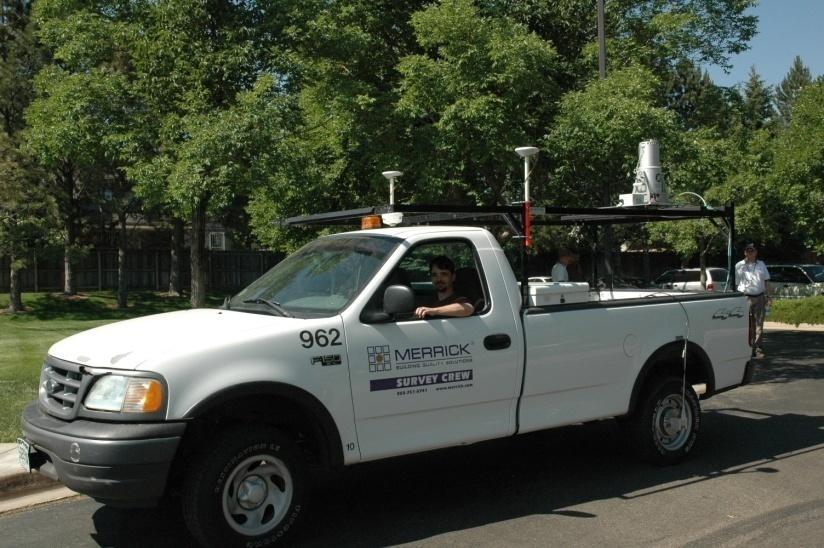
8 What is LiDAR? LiDAR (Light detection and ranging) is an active optical technology that uses pulses of laser light to strike the surface of the earth and measure the time of each pulse return to derive an accurate elevation. Airborne LiDAR data acquisition system includes: LiDAR sensor Digital camera(s) Airborne GPS IMU (Inertial Measurement Unit) Power Supply / Data Storage Pilot / Flight Operator


9 LiDAR Acquisition Platforms

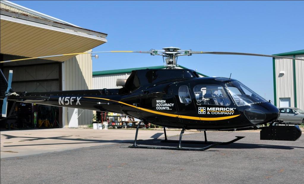
10 LiDAR Platform - Benefits Airborne Fixed Wing Ideal for large, contiguous areas with low ground sample distance (GSD); 1 8 points per square meter Supports simultaneous collection of LiDAR & digital imagery Airborne Helicopter Well-suited for narrow corridors (ex. utility, transportation) and small area, high-density collections; 10 1,000+ points per square meter Ideal for high precision mapping required for additional corridor tracks, highway lane widening, and utility corridor construction Mobile High GSD with survey grade accuracy Ideal for complex railroad environments


11 Data Differences Higher LiDAR Density Fixed Wing LiDAR Example Approx. 1-2 points / square meter Helicopter LiDAR Example Approx points / square meter

 Flight Time Over target = 0.")
12 Flight Efficiencies Powerline project flown by Merrick s Cessna 402C; 24 miles in length; 0.5 meter GSD Fixed Wing Results: Turn Radius: 4 7 miles Turn Length: 9 20 miles Turn Time: 4 8 minutes each Flight Time Over target = 0.5 hours (15%) Flight Turns = 1.8 hours (59%) Flight Taxi = 0.8 hours (26%) TOTAL = 3.1 hours Helicopter Results: Flight Time: 20 minutes each 9x savings in flight time (over fixed wing) Flight Time Over target = 0.2 hours (61%) Flight Turns = 0.1 hours (30%) Flight Taxi = 0.03 hours (9%) TOTAL = 0.34 hours

13 Project Challenges Base Station Placement Proper placement of GPS base stations required within the long, thin ROW to maintain accuracy of the LiDAR data Changing Zones Railroad corridor passes through three California state plane zones and requires 15 modification factors within the state plane zones
 GPS base stations need")
14 Ground Survey Support Base Stations To achieve the required one-foot contour interval in the final mapping products, the aircraft should never fly more than 25 miles from a GPS base station To optimize data accuracy, a 15 mile limit was set for the BNSF project, thus, base stations would have to be set-up about 30 miles apart along the ROW corridor Per day, six (6) GPS base stations need to be placed so the aircraft could cover significant area per flight

15 Ground Survey Support Thinking ahead to GPS-based machine grading during construction, the client requested to have base station validation points set every mile within the ROW corridor At every fifth mile, crews drove 7 foot stainless steel rods into the ground near the railroad track Each mile in between was marked with a 2 foot length of #5 rebar Both rods were topped with 2 inch aluminum caps bearing the control point number

16 Modification Factors 15 modification factors required to support moving from state plane projection to ground coordinates without introducing error in the process The 453 mile ROW corridor was divided into 24 segments determined by combined factors that would yield less than one-tenth of a foot error along its entire length
17 GIS Data Integration Utilizing the high-precision LiDAR data and orthophotography, Merrick delivered highly accurate planimetric basemap features in compatible formats for ESRI ArcGIS and Microstation hardware platforms Modified Projection Files were established for each of the 24 ROW corridor segments Customized ESRI ArcReader viewer application developed to support client s internal needs Merrick provided application training to BNSF personnel; user feedback helped refine functionality of application

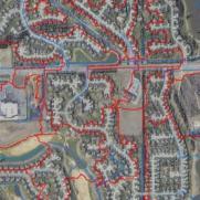
18 GIS Data Viewer

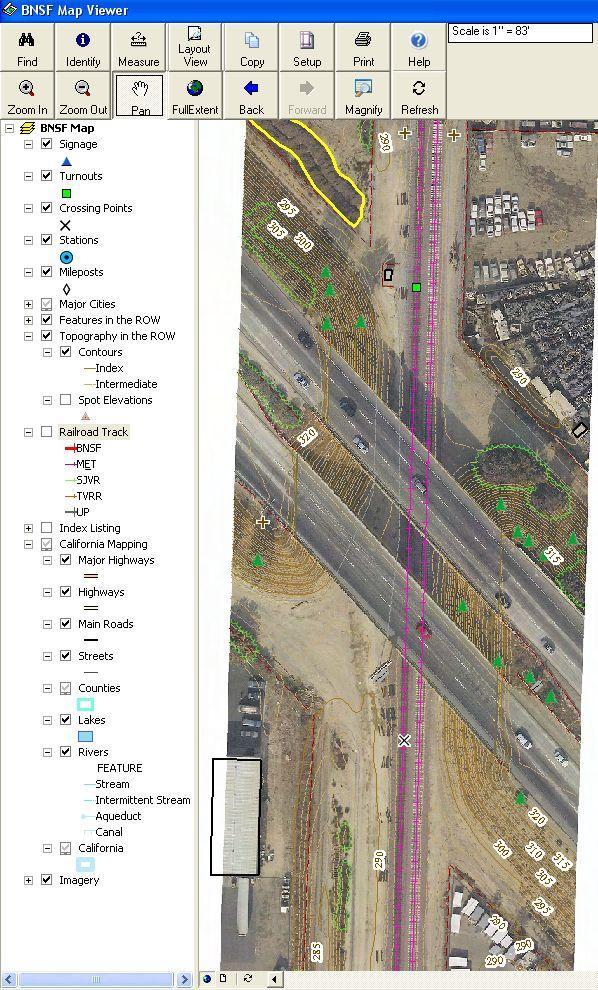
19 GIS Data Viewer

20 GIS Data Viewer

21 GIS Data Viewer
22 Project Benefits to BNSF Optimized Route Design and Selection Railway Modeling (congestion points) Proactive positioning to expedite engineering design Enhanced project estimation capabilities All project data available from external hard drive for on-call and pre-qualified consultants Participating End-users: BNSF Engineering / Public Projects / Environmental CA Div. of Rail, CA High Speed Rail, Amtrak Engineering Consultants (Design, Environmental)


23 LiDAR in Railroad Corridor

24 3D View of LiDAR in Railroad Corridor


25 Railroad Corridor LiDAR Data Rendering
26 Advanced Data Modeling


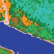
27 Railroad Corridor Breakline Compilation Stream Water Feature Stream defined by breakline; contour display Stream displayed in orthophoto
28 Railroad Corridor Grade Analysis Profile View of LiDAR


29 Railroad Corridor Bridge Feature View of Bridge Profile Oblique View of Bridge
30 Presenter Bio Bill Emison Senior Account Mgr. / MARS Product Mgr. (GeoSpatial Solutions) Professional experience includes solutions consulting, software / service sales and technical marketing B.S., Business Administration, University of Louisville, (Louisville, Kentucky) M.S., City Planning (GIS), Georgia Institute of Technology, (Atlanta, Georgia) bill.emison@merrick.com Direct: (303) Twitter
31 Presenter Bio Troy Kelts Project Engineer, Civil Engineering Solutions (CES) Focused on public and private infrastructure projects Registered Professional Engineer (PE) in Colorado, Louisiana, and Alaska B.S., Civil Engineering, Michigan State University, (East Lansing, Michigan) Direct: (303)
Methane to Markets Partnership Expo. Remote Sensing - Aerial Leak Detection and Measurement. ANGEL Service Airborne Natural Gas Emission Lidar
 Methane to Markets Partnership Expo. Remote Sensing - Aerial Leak Detection and Measurement ANGEL Service Airborne Natural Gas Emission Lidar Wednesday, October 31, 2007 Daniel Brake Director, ANGEL Service
THE ULTIMATE DRONE SOLUTION
 THE ULTIMATE DRONE SOLUTION LX-1 ECHELON LiDAR MULTIROTOR Brochure & Technical Specifications OVERVIEW The LX-1 Echelon is a professional-grade hexacopter equipped with a LiDAR sensing payload, and designed
Electric Vehicle Infrastructure Location Tool and Visualization Map
 Electric Vehicle Infrastructure Location Tool and Visualization Map NASEO Northeast Regional Meeting April 12, 2018 Agenda Electric Vehicle Fast Charging Infrastructure Planning Tools Overview & Analysis
Harris Geospatial Solutions
 Harris Geospatial Solutions Esri India User Conference December 13-14, 2017 Delhi Cherie Muleh Software & Technology Geospatial software solutions and supporting technologies to get the most from your
An Overview of High Speed Rail. David Randall Peterman Congressional Research Service
 An Overview of High Speed Rail David Randall Peterman Congressional Research Service 1 Defining High Speed Rail in the U.S. What is High Speed Rail? Allusions to world-class European and Asian systems
Final Series of Public Meetings
 Final Series of Public Meetings Public Meeting Locations City Date Jasper Monday, September 26 Livingston Tuesday, September 27 Huntsville Wednesday, September 28 Bryan Thursday, September 29 Eldorado
Comprehensive Regional Goods Movement Plan and Implementation Strategy Goods Movement in the 2012 RTP/SCS
 Comprehensive Regional Goods Movement Plan and Implementation Strategy Goods Movement in the 2012 RTP/SCS Annie Nam Southern California Association of Governments September 24, 2012 The Goods Movement
Monitoring Bank Erosion On the Missouri River, Lower Brule Reservation
 Monitoring Bank Erosion On the Missouri River, Lower Brule Reservation A cooperative study between the Lower Brule Sioux Tribe s Environmental Protection Office and the U.S. Geological Survey, with assistance
Electric Vehicle Infrastructure Location Tool and Visualization Map
 Electric Vehicle Infrastructure Location Tool and Visualization Map Analysis and Methodology Overview February 2018 Agenda Electric Vehicle Fast Charging Infrastructure Planning Tools Overview & Analysis
House Committee on Transportation Policy Public Hearing HB April 5, 2017
 REPRESENTATIVE RICH VIAL OREGON HOUSE OF REPRESENTATIVES HOUSE DISTRICT 26 House Committee on Transportation Policy Public Hearing HB 3231 April 5, 2017 Background House District 26 Wilsonville Sherwood
David Chow, P.E., AICP Director, IBI Group
 David Chow, P.E., AICP Director, IBI Group Existing Conditions get worst ROADWAY CONDITIONS IN 2030 Daily delay goes from 2.2 to up to 5.4 million hours lost in congestion Unreliability of the roadway
mileage fees primer vmt fees are in your future
 mileage fees primer vmt fees are in your future background vmt fees traffic growth (esp trucks) CAFE + battery cars + efficient trucks = declining $$$ gas tax inflation vs. /gallon taxes system management
ALAMEDA CORRIDOR. A A Project of National Significance. TRB Summer Conference MTS as a Component of the Nation s Transportation System June 25, 2002
 ALAMEDA CORRIDOR A A Project of National Significance TRB Summer Conference MTS as a Component of the Nation s Transportation System June 25, 2002 Top U.S. Container Ports (2001) LOS ANGELES 5.18 LONG
Electric Vehicle Infrastructure Location Tool and Visualization Map. July 17, 2018
 Electric Vehicle Infrastructure Location Tool and Visualization Map Version 2.0 Analysis Summary July 17, 2018 Contents Electric Vehicle Fast Charging Infrastructure Planning Tools Overview & Analysis
NORTH HOUSTON HIGHWAY IMPROVEMENT PROJECT (NHHIP): SEGMENT 3. April 19, 2018 NHHIP April 19, 2018
: SEGMENT 3. April 19, 2018 NHHIP April 19, 2018") NORTH HOUSTON HIGHWAY IMPROVEMENT PROJECT (NHHIP): SEGMENT 3 April 19, 2018 NHHIP OVERVIEW NHHIP divided into 3 Segments: Segment 1: I-45: Beltway 8 to I-610 (9 mi) 45 Segment 2: I-45: I-610 to I-10 (3
NORTH HOUSTON HIGHWAY IMPROVEMENT PROJECT (NHHIP): SEGMENT 3 April 19, 2018 NHHIP OVERVIEW NHHIP divided into 3 Segments: Segment 1: I-45: Beltway 8 to I-610 (9 mi) 45 Segment 2: I-45: I-610 to I-10 (3
Emerging Technologies & Autonomous Vehicle Readiness Planning. Georgia Planning Association Conference Jekyll Island, GA September 5, 2018
 Emerging Technologies & Autonomous Vehicle Readiness Planning Georgia Planning Association Conference Jekyll Island, GA September 5, 2018 Agenda 1 U.S. Context 2 U.S. Survey on Emerging Technologies &
Exhibit F - UTCRS. 262D Whittier Research Center P.O. Box Lincoln, NE Office (402)
") UTC Project Information Project Title University Principal Investigator PI Contact Information Funding Source(s) and Amounts Provided (by each agency or organization) Exhibit F - UTCRS Improving Safety
UTC Project Information Project Title University Principal Investigator PI Contact Information Funding Source(s) and Amounts Provided (by each agency or organization) Exhibit F - UTCRS Improving Safety
TRANSFORMING TRANSPORTATION
 TRANSFORMING TRANSPORTATION WITH ELECTRICITY: STATE ACTION MARCH 3, 2014 KRISTY HARTMAN ENERGY POLICY SPECIALIST NCSL NCSL OVERVIEW Bipartisan organization Serves the 7,383 legislators and 30,000+ legislative
PORTS-TO-PLAINS. Corridor Planning. Ports-to-Plains Stakeholder Meeting
 PORTS-TO-PLAINS Corridor Planning Stakeholder Workshop - Agenda 1 Purpose of Stakeholder Workshops 3 2 Rural Transportation System Overview 4 3 Ports-to-Plains 8 4 5 6 7 I-27 Expansion Key Considerations
US DOE Community Partner Projects: U.S. Fuels Across America's Highways -- Michigan to Montana (M2M)
") US DOE Community Partner Projects: U.S. Fuels Across America's Highways -- Michigan to Montana (M2M) Ted Barnes, P.E. Gas Technology Institute April 2018 Company Overview Independent, not-for-profit established
US DOE Community Partner Projects: U.S. Fuels Across America's Highways -- Michigan to Montana (M2M) Ted Barnes, P.E. Gas Technology Institute April 2018 Company Overview Independent, not-for-profit established
Training Course Catalog
 Geospatial exploitation Products (GXP ) Training Course Catalog Revised: June 15, 2016 www.baesystems.com/gxp All scheduled training courses held in our regional training centers are free for current GXP
Transportation Infrastructure WGF 2017
 Transportation Infrastructure WGF 2017 Stuart Woods VP Geospatial Division Leica Geosystems AG. Growing Population THE WORLD'S POPULATION IS GROWING TODAY 7.4BN - 10BN IN 40 YEARS 2 Mapping the Unknown
Point A Point B Point C Point D. Fulton County Board of Commissioners and Mayors Meeting December 14, 2017
 Fulton County Board of Commissioners and Mayors Meeting December 14, 2017 Master Plan Overview Phase 1 Community Vision and Existing Transit Conditions Phase 2 Scenario Development Phase 3 Transit Master
Gamuda Berhad (GAMUDA) - Financial and Strategic SWOT Analysis Review
 - Financial and Strategic SWOT Analysis Review") Gamuda Berhad (GAMUDA) - Financial and Strategic SWOT Analysis Review Gamuda Berhad (GAMUDA) - Financial and Strategic SWOT Analysis Review Sector Publishing Intelligence Limited (SPi) has been marketing
Gamuda Berhad (GAMUDA) - Financial and Strategic SWOT Analysis Review Gamuda Berhad (GAMUDA) - Financial and Strategic SWOT Analysis Review Sector Publishing Intelligence Limited (SPi) has been marketing
FLYING CAR NANODEGREE SYLLABUS
 FLYING CAR NANODEGREE SYLLABUS Term 1: Aerial Robotics 2 Course 1: Introduction 2 Course 2: Planning 2 Course 3: Control 3 Course 4: Estimation 3 Term 2: Intelligent Air Systems 4 Course 5: Flying Cars
Kenosha-Racine-Milwaukee (KRM)
") Kenosha-Racine-Milwaukee (KRM) Commuter Rail #147925 November 6, 2009 1 Guidance of KRM Commuter Rail Studies Intergovernmental Partnership Technical Steering Committee Temporary and Limited Authority
Kenosha-Racine-Milwaukee (KRM) Commuter Rail #147925 November 6, 2009 1 Guidance of KRM Commuter Rail Studies Intergovernmental Partnership Technical Steering Committee Temporary and Limited Authority
CITY OF ANN ARBOR, MICHIGAN 301 E. Huron St., P.O. Box 8647 Ann Arbor, Michigan
 Date: Wednesday, June 18, 2014 Location: Ann Arbor District Library Attendees: 14 citizen attendees Ann Arbor Station Environmental Review Citizen Working Group Meeting Notes Meeting #3 The third meeting
MnDOT s Experience with IRI Specifications
 MnDOT s Experience with IRI Specifications Spring 2013 NCC Meeting April 4, 2013 Philadelphia, PA Maria Masten, P.E. MnDOT Concrete Engineer Evolution of Smoothness No Equipment Certification 2002 Profiler
East San Fernando Valley Transit Corridor. Community Meetings April/May, 2012
 East San Fernando Valley Transit Corridor Community Meetings April/May, 2012 Meeting Format Sign-In/Open-House 6:00 P.M. to 6:30 P.M. Welcome/Presentation 6:30 P.M. to 7 P.M. Open-House 7:00 P.M. to 8:00
High-Speed Intercity Passenger Rail
 September 13, 2011 LTRC Seminar Series: Congestion Management Baton Rouge New Orleans High-Speed Intercity Passenger Rail AGENDA LTRC Seminar Series: Congestion Management Baton Rouge, Louisiana Project
Successful Passenger Rail in the State of California
 Successful Passenger Rail in the State of California Texas Transportation Forum Austin, Texas Eugene K. Skoropowski, Managing Director Capitol Corridor Joint Powers Authority (CCJPA) Oakland, California
U.S. Rail Crude Oil Traffic
 U.S. Rail Crude Oil Traffic Association of American Railroads November 215 Summary U.S. crude oil production has risen sharply in recent years, with much of the increased output moving by rail. In 28,
ORANGELINE HIGH SPEED MAGLEV
 ORANGELINE HIGH SPEED MAGLEV Infrastructure Investment Opportunity 50-year Financial Projection Project Cash Surplus $23,312,080,297 Operating Reserves $2,000,132,327 Station-area Improvements and Feeder
Orange Line Bus Rapid Transit (BRT) Improvements San Fernando Valley Service Council April 3, 2019
 Improvements San Fernando Valley Service Council April 3, 2019") Orange Line Bus Rapid Transit (BRT) Improvements San Fernando Valley Service Council April 3, 2019 1 Measure M Transit Projects in San Fernando Valley 2 1 2 Measure M Transit Projects Schedule Project
Orange Line Bus Rapid Transit (BRT) Improvements San Fernando Valley Service Council April 3, 2019 1 Measure M Transit Projects in San Fernando Valley 2 1 2 Measure M Transit Projects Schedule Project
RETURN ON INVESTMENT LIQUIFIED NATURAL GAS PIVOTAL LNG TRUCK MARKET LNG TO DIESEL COMPARISON
 RETURN ON INVESTMENT LIQUIFIED NATURAL GAS PIVOTAL LNG TRUCK MARKET LNG TO DIESEL COMPARISON Year 1 Year 2 Year 3 Year 4 Year 5 Year 6 Year 7 Year 8 Year 9 Year 10 RETAIL BREAK EVEN AND IRR EXAMPLE FOR
6/6/2018. June 7, Item #1 CITIZENS PARTICIPATION
 June 7, 2018 Item #1 CITIZENS PARTICIPATION 1 Item #2 APPROVAL OF MINUTES Item #3 TRAC GOALS, FRAMEWORK & AGENDA REVIEW 2 COMMITTEE GOALS Learn about Southern Nevada s mobility challenges, new developments
Eye In The Sky: The Future of Risk Assessment From Above
 Eye In The Sky: The Future of Risk Assessment From Above Property Insurance Report National Conference 15 November 2010 Timothy E. Carone, Ph.D. Director, Global Climate Monitoring Systems Advanced Programs
Journal of Emerging Trends in Computing and Information Sciences
 Pothole Detection Using Android Smartphone with a Video Camera 1 Youngtae Jo *, 2 Seungki Ryu 1 Korea Institute of Civil Engineering and Building Technology, Korea E-mail: 1 ytjoe@kict.re.kr, 2 skryu@kict.re.kr
Bus Rapid Transit. Jennifer Flynn and Cheryl Thole Senior Research Associates Commuter Choice Workshop January 2012 Tampa, FL
 Bus Rapid Transit Jennifer Flynn and Cheryl Thole Senior Research Associates Commuter Choice Workshop January 2012 Tampa, FL What is Bus Rapid Transit? BRT is an enhanced bus system that operates on bus
UCLA Lake Arrowhead Conference. October 18, 2010
 BART Click to Capacity edit Master Overview title style for UCLA Lake Arrowhead Conference October 18, 2010 0 BART Basics 360,000 daily riders 104 miles 43 stations 1.3 billion annual passenger miles 1
Jay Gundlach AIAA EDUCATION SERIES. Manassas, Virginia. Joseph A. Schetz, Editor-in-Chief. Blacksburg, Virginia. Aurora Flight Sciences
 Jay Gundlach Aurora Flight Sciences Manassas, Virginia AIAA EDUCATION SERIES Joseph A. Schetz, Editor-in-Chief Virginia Polytechnic Institute and State University Blacksburg, Virginia Published by the
Impact of Autonomous Vehicles on a Typical Canadian City
 Impact of Autonomous Vehicles on a Typical Canadian City Barrie Kirk, P.Eng. Paul Godsmark May 27, 2013 Globis Consulting ITSC ACGM May 2013 2 Globis Consulting ITSC ACGM May 2013 3 Globis Consulting ITSC
Kendall Drive Premium Transit PD&E Study Project Kick-Off Meeting SR 94/Kendall Drive/SW 88 Street Project Development and Environment (PD&E) Study
 Study") Florida Department of Transportation District Six Kendall Drive Premium Transit PD&E Study Project Kick-Off Meeting SR 94/Kendall Drive/SW 88 Street Project Development and Environment (PD&E) Study What
Florida Department of Transportation District Six Kendall Drive Premium Transit PD&E Study Project Kick-Off Meeting SR 94/Kendall Drive/SW 88 Street Project Development and Environment (PD&E) Study What
D-25 Speed Advisory System
 Report Title Report Date: 2002 D-25 Speed Advisory System Principle Investigator Name Pesti, Geza Affiliation Texas Transportation Institute Address CE/TTI, Room 405-H 3135 TAMU College Station, TX 77843-3135
Sustainable Transportation Award Winner. UC/CSU Sustainability Conference Santa Barbara, 2006
 Sustainable Transportation Award Winner UC/CSU Sustainability Conference Santa Barbara, 2006 Translocator (Transit Locator) San Jose State University CSU: Transportation Demand Management Eyedin Zonobi,
Super Squadron technical paper for. International Aerial Robotics Competition Team Reconnaissance. C. Aasish (M.
 Super Squadron technical paper for International Aerial Robotics Competition 2017 Team Reconnaissance C. Aasish (M.Tech Avionics) S. Jayadeep (B.Tech Avionics) N. Gowri (B.Tech Aerospace) ABSTRACT The
Proposed Project I 35 Improvements from SH 195 to I 10
 I 35 ROADWAY Proposed Project I 35 Improvements from SH 195 to I 10 The existing I 35 facility from State Highway 195 (SH 195) north of Georgetown to Interstate 10 (I 10) in San Antonio varies from four
SPECIAL MISSION AIRCRAFT
 SPECIAL MISSION AIRCRAFT precision from above FACTS AND SPECIFICATIONS DA42 MPP Guardian - Facts and Specifications Power plant Engine Propeller Fuel grades 2x AUSTRO ENGINE AE300 (168 hp, turbo charged)
SHRP 2 RID. Roadway Information Database
 SHRP 2 RID Roadway Information Database Research Team CTRE/Iowa State University: Omar Smadi Neal Hawkins Zach Hans Basak Bektas Nick Burdine Cambridge Systematics: Bruce Spear Kevin Howard Goal Design,
Clarksville Street Department. Fiscal Year 2018 Budget Presentation
 Clarksville Street Department Fiscal Year 2018 Budget Presentation Clarksville Street Department FY 2018 Proposed Budget 4.2% 42.0% Salaries/Benefits 53.8% Operating Expenses Capital Outlay Clarksville
DIVISION V SURFACINGS AND PAVEMENTS
 36-3.01 GENERAL DIVISION V SURFACINGS AND PAVEMENTS 36 GENERAL 04-20-18 Replace section 36-3 with: 36-3 PAVEMENT SMOOTHNESS 36-3.01A Summary Section 36-3 includes specifications for measuring the smoothness
Goods Movement Plans. Summary of Needs Assessments. January 21, 2015 GOODS MOVEMENT COLLABORATIVE AND GOODS MOVEMENT PLAN 6
 Goods Movement Plans Summary of Needs Assessments January 21, 2015 GOODS MOVEMENT COLLABORATIVE AND GOODS MOVEMENT PLAN 6 Goods Movement Vision and Goals GOODS MOVEMENT COLLABORATIVE AND GOODS MOVEMENT
Task Force Meeting January 15, 2009
 Task Force Meeting January 15, 2009 Study Update August 14 th Task Force Meeting Update on Traffic Projections and Financial Feasibility Study presented by Kane County and WSA staff The presentation summarized
Quarterly Update Meeting
 Quarterly Update Meeting December 6, 2011 www.dcstreetcar.com / hotline: (855)413-2954 Agenda I. Welcome II. System Overview III. Project Update IV. Upcoming Meetings V. Stay Connected Provided by DC Streetcar
Update of the Midwest Regional Rail Initiative. Tim Hoeffner Michigan Department of Transportation Director, Office of Rail Lansing, MI
 Update of the Midwest Regional Rail Initiative Tim Hoeffner Michigan Department of Transportation Director, Office of Rail Lansing, MI Key Presentation Take-Aways Status of Midwest Regional Rail Initiative
TRAFFIC VOLUME TRENDS
 Page 1 U. S. Department Transportation Federal Highway Administration Office Highway Policy Information TRAFFIC VOLUME TRENDS September Travel on all roads and streets changed by +2.5 (5.8 billion vehicle
Open House. Highway212. Meetings. Corridor Access Management, Safety & Phasing Plan. 5:30 to 6:30 p.m. - Southwest Corridor Transportation Coalition
 Welcome Meetings 5:30 to 6:30 p.m. - Southwest Corridor Transportation Coalition 6:30 to 8:00 p.m. - Open House Why is Highway 212 Project Important? Important Arterial Route Local Support Highway 212
WASHINGTON STATE ROAD USAGE CHARGE ASSESSMENT
 1 WASHINGTON STATE ROAD USAGE CHARGE ASSESSMENT Anthony L. Buckley Director, Office of Innovative Partnerships Washington State Department of Transportation Overview: Washington State Infrastructure 2
AUTONOMOUS VEHICLES & HD MAP CREATION TEACHING A MACHINE HOW TO DRIVE ITSELF
 AUTONOMOUS VEHICLES & HD MAP CREATION TEACHING A MACHINE HOW TO DRIVE ITSELF CHRIS THIBODEAU SENIOR VICE PRESIDENT AUTONOMOUS DRIVING Ushr Company History Industry leading & 1 st HD map of N.A. Highways
SEPULVEDA PASS CORRIDOR
 SEPULVEDA PASS CORRIDOR PUBLIC PRIVATE PARTNERSHIP DELIVERY PRE-DEVELOPMENT AGREEMENT PDA Sepulveda Pass Mobility Issues Most congested highway segment in the U.S. 295,000 vehicles per day (2010) 430,000
AUTOPILOT Webinar Series (II): Developing Automated Driving Pilots for IoT: Brainport
: Developing Automated Driving Pilots for IoT: Brainport") AUTOPILOT Webinar Series (II): Developing Automated Driving Pilots for IoT: Brainport 31 May 2018 16.00-17.00 CET 31/05/2018 This project has received funding from the European Union s Horizon 2020 research
AUTOPILOT Webinar Series (II): Developing Automated Driving Pilots for IoT: Brainport 31 May 2018 16.00-17.00 CET 31/05/2018 This project has received funding from the European Union s Horizon 2020 research
SH 249 IN GRIMES COUNTY. Open House April 3, 2014
 SH 249 IN GRIMES COUNTY Open House April 3, 2014 Meeting Agenda Purpose of Meeting Today: Review the purpose and need for the SH 249 Grimes County project Review the proposed project and alternatives Discuss
4 COSTS AND OPERATIONS
 4 COSTS AND OPERATIONS 4.1 INTRODUCTION This chapter summarizes the estimated capital and operations and maintenance (O&M) costs for the Modal and High-Speed Train (HST) Alternatives evaluated in this
Efficiency Matters for Mobility. Presented at A3PS ECO MOBILITY 2018 Vienna, Austria November 12 th and 13 th, 2018
 Efficiency Matters for Mobility High-Performance, Ann M. Schlenker Agent-Based Director, Simulation Center for of Transportation Travelers Research and Transportation Argonne National Laboratory Systems
TRAFFIC VOLUME TRENDS July 2002
 TRAFFIC VOLUME TRENDS July 2002 Travel on all roads and streets changed by +2.3 percent for July 2002 as compared to July 2001. Estimated Vehicle-Miles of Travel by Region - July 2002 - (in Billions) West
Dynamic Hard Shoulder Running
 Dynamic Hard Shoulder Running Lessons Learned from the US and UK Experience Ryan Gulick, PE David Kamnitzer 1 Overview What is Hard Shoulder Running? HSR in the US Washington State DOT Experience HSR in
I-95 Corridor Coalition Vehicle Probe Project: HERE, INRIX and TOMTOM Data Validation. Report for North Carolina (#08) I-240, I-40 and I-26
 I-240, I-40 and I-26") I-95 Corridor Coalition Vehicle Probe Project: HERE, INRIX and TOMTOM Data Validation Report for North Carolina (#08) I-240, I-40 and I-26 Prepared by: Masoud Hamedi, Sanaz Aliari University of Maryland,
I-95 Corridor Coalition Vehicle Probe Project: HERE, INRIX and TOMTOM Data Validation Report for North Carolina (#08) I-240, I-40 and I-26 Prepared by: Masoud Hamedi, Sanaz Aliari University of Maryland,
PACIFIC AEROSTAR L.L.C.
 PACIFIC AEROSTAR L.L.C. EXECUTIVE SUMMARY PACIFIC AEROSTAR L.L.C. WAS FORMED PRIMARILY TO PROVIDE LEADING EDGE FLIGHT AND GROUND TRAINING FOR THE AEROSTAR OWNER/OPERATOR. THE COMPANY S SECONDARY GOAL IS
The connected vehicle is the better vehicle!
 AVL Tagung Graz, June 8 th 2018 Dr. Rolf Bulander 1 Bosch GmbH 2018. All rights reserved, also regarding any disposal, exploitation, reproduction, editing, distribution, as well as in the event of applications
Harlem Avenue between 63 rd and 65 th
 Harlem Avenue between 63 rd and 65 th Community Advisory Group Meeting #3 December 1, 2017 Bedford Park Public Library 1 Meeting Agenda 1. Welcome/Introductions (3 mins) 2. Project Overview and Re-Cap
Public Information Workshop
 Public Information Workshop Charlotte County-Punta Gorda MPO - Meeting Rooms A and B March 29, 2018 Welcome to the Public Information Workshop for Harborview Road Project Development and Environment (PD&E)
Content. Introduction. Technology. Type of unmanned vehicle. Past, Present, Future. Conclusion
 Introduction Content Technology Type of unmanned vehicle Past, Present, Future Conclusion What is unmanned vehicles? l Without a person on board l Remote controlled l Remote guided vehicles Reduce casualty
MPO Staff Report Technical Advisory Committee: July 12, 2017
 MPO Staff Report Technical Advisory Committee: July 12, 2017 RECOMMENDED ACTION: 2 nd TAC Meeting with Kimley-Horn/WSB in Updating the Street/Highway Element of 2045 Metropolitan Transportation Plan. Matter
Harlem Avenue between 63 rd and 65 th
 Harlem Avenue between 63 rd and 65 th Public Meeting #2 March 13, 2018 Summit Park District Welcome to the second Public Meeting for the preliminary engineering and environmental studies of Illinois 43
Austrian Show Case Disaster Relief. Diamond Aircraft, Hanoi February DAI-Marketing/Mandl
 Austrian Show Case Disaster Relief Diamond Aircraft, Hanoi 20 21 February 2012 Multiple requirements Multi Purpose Platform 1. Company Movie 2. Company presentation 3. Disaster relief 4. Security 5. One-stop
Chicago Milwaukee Intercity Passenger Rail Corridor
 Chicago Milwaukee Intercity Passenger Rail Corridor Past, Present, and Future Arun Rao, Passenger Rail Manager Wisconsin Department of Transportation Elliot Ramos, Passenger Rail Engineer Illinois Department
An overview of the on-going OSU instrumented probe vehicle research
 An overview of the on-going OSU instrumented probe vehicle research Benjamin Coifman, PhD Associate Professor The Ohio State University Department of Civil, Environmental, and Geodetic Engineering Department
Aircraft Pollution Monitoring Project
 National Institute for Aerospace Research Elie Carafoli INCAS Bucharest Aircraft Pollution Monitoring Project Authors: Andreea BOSCORNEA Violeta Andreea ANASTASE Sorin Nicolae VAJAIAC London, 4 th November
Deep Learning Will Make Truly Self-Driving Cars a Reality
 Deep Learning Will Make Truly Self-Driving Cars a Reality Tomorrow s truly driverless cars will be the safest vehicles on the road. While many vehicles today use driver assist systems to automate some
Soldier Summit + Salt Lake City Route Extension Scenario Pack 01
 Realistic Contemporary and Historical Scenarios for Train Simulator About High Iron Simulations We began serving the Train Simulator community in October 2012 by developing and publishing free Train Simulator
Pomona Rotary December 19, 2017
 Pomona Rotary December 19, 2017 Los Angeles County s population will grow by 5.9% to 10.7 million by 2024 During that same period, the San Gabriel Valley will grow by 7.6% to more than 1.5 million; taking
6/11/2018. June 7, Item #1 CITIZENS PARTICIPATION
 June 7, 2018 Item #1 CITIZENS PARTICIPATION 1 Item #2 APPROVAL OF MINUTES Item #3 TRAC GOALS, FRAMEWORK & AGENDA REVIEW 2 COMMITTEE GOALS Learn about Southern Nevada s mobility challenges, new developments
The Implications of Automated Vehicles for the Public Transit Industry
 The Implications of Automated Vehicles for the Public Transit Industry June 22, 2016 Presentation to I-95 Corridor Coalition Jerome M. Lutin, Ph.D., P.E. Senior Director of Statewide & Regional Planning
Bild : Bernhard Mühr German Aerospace Center Flight Operations
 German Aerospace Center Flight Operations Bild : Bernhard Mühr www.wolkenatlas.de Introduction DLR is Germany s aerospace research center and space agency with about 4700 employees in 31 research institutes
Plan Check Policies and Guidelines
 Plan Check Policies and Guidelines VII. A. INTRODUCTION Traffic signing and striping plans are required for all General Plan Roads and any roadway that is 56-foot wide curb-to-curb (78 R/W) or wider. Transportation
American Center for Mobility
 American Center for Mobility Pennsylvania Transportation Engineering And Safety Conference December 5, 2018 Mark Chaput, P.E. VP of Facility Operations and Construction American Center for Mobility Restricted
CROSSING RAIL PROJECT (P4) RAIL
 RAIL") GRAND CROSSING RAIL PROJECT (P4) Community Advisory Group October 10, 2012 1:30 pm Grand Crossing Park Field House 7655 S. Ingleside Avenue, Chicago GRAND CROSSING RAIL PROJECT (P4) Community Advisory
GRAND CROSSING RAIL PROJECT (P4) Community Advisory Group October 10, 2012 1:30 pm Grand Crossing Park Field House 7655 S. Ingleside Avenue, Chicago GRAND CROSSING RAIL PROJECT (P4) Community Advisory
UCLA Lake Arrowhead Conference. October 18, 2010
 BART Click to Capacity edit Master Overview title style for UCLA Lake Arrowhead Conference October 18, 2010 0 BART Basics 360,000 daily riders 104 miles 43 stations 1.3 billion annual passenger miles 1
UCLA Lake Arrowhead Conference. October 18, 2010
 BART Click to Capacity edit Master Overview title style for UCLA Lake Arrowhead Conference October 18, 2010 0 BART Basics 360,000 daily riders 104 miles 43 stations 1.3 billion annual passenger miles 1
Robots on Our Roads: The Coming Revolution in Mobility. Ohio Planning Conference July 27, 2016 Richard Bishop
 Robots on Our Roads: The Coming Revolution in Mobility Ohio Planning Conference July 27, 2016 Richard Bishop Myths! The roads need to be changed to make automated driving possible. WRONG! All vehicles
Aurora Line/I-225 Rail Project Update Public Meeting. June 4, 2014
 Aurora Line/I-225 Rail Project Update Public Meeting June 4, 2014 FasTracks and I-225 Rail Line Update Danielle Smith I-225 Rail Line Design/Build Coordination Manager 2 The RTD FasTracks Plan 122 miles
Analysts/Fund Managers Visit 19 April Autonomous Systems and Future Capability Mark Kane
 Analysts/Fund Managers Visit 19 April 2007 Autonomous Systems and Future Capability Mark Kane The Rationale for UAVs The Rationale for UAVs UAVs generally seen to carry out the dull, dirty, and dangerous
Introduction Projects Basic Design Perception Motion Planning Mission Planning Behaviour Conclusion. Autonomous Vehicles
 Dipak Chaudhari Sriram Kashyap M S 2008 Outline 1 Introduction 2 Projects 3 Basic Design 4 Perception 5 Motion Planning 6 Mission Planning 7 Behaviour 8 Conclusion Introduction Unmanned Vehicles: No driver
This corridor section will carry commuter trains from Portland to Longview/Kelso, CHSR inter-city and inter-city express trains.
 Alignment is double tracked for 186 mph speeds. This corridor section will carry commuter trains from Portland to Longview/Kelso, CHSR inter-city and inter-city express trains. BNSF right-of-way will be
THE CITY OF CHATTANOOGA SMART TRANSPORTATION SYSTEMS
 THE CITY OF CHATTANOOGA SMART TRANSPORTATION SYSTEMS SMART TRANSPORTATION SYSTEMS What comes to mind when we mention the term Smart Transportation? or its more generic term ITS. (Intelligent Transportation
A Transit Plan for the Future. Draft Network Plan
 A Transit Plan for the Future Draft Network Plan Project Overview and Status Completed Market Analysis and Service Evaluation. Developed Plan Framework and Guiding Principles. Developed a draft Five Year
The Role of Research in Transit Operations
 The Role of Research in Transit Operations Rod Diridon, Sr. President and Founder (1968-77) Decision Research Institute Member (1994-04) and Past Chair Transit Cooperative Research Program Executive Director
Port Terminal Railroad Association. Committed to Safety and Service
 Port Terminal Railroad Association Committed to Safety and Service Port Terminal Railroad History Port Terminal Railroad History The Port Terminal Railroad Association (PTRA), formed in 1924, is the culmination
Engineering Dept. Highways & Transportation Engineering
 The University College of Applied Sciences UCAS Engineering Dept. Highways & Transportation Engineering (BENG 4326) Instructors: Dr. Y. R. Sarraj Chapter 4 Traffic Engineering Studies Reference: Traffic
Plan Check Policies and Guidelines
 VIII. TRAFFIC SIGNING AND STRIPING PLANS A. INTRODUCTION Traffic signing and striping plans are required for all General Plan Roads and any roadway that is 56-foot wide curb-to-curb (78 R/W) or wider.