SHRP 2 RID. Roadway Information Database
|
|
|
- Madeleine Harrison
- 5 years ago
- Views:
Transcription


1 SHRP 2 RID Roadway Information Database
2 Research Team CTRE/Iowa State University: Omar Smadi Neal Hawkins Zach Hans Basak Bektas Nick Burdine Cambridge Systematics: Bruce Spear Kevin Howard

3 Goal Design, Build, and Populate Roadway Information Database Linked to Support Safety Analysis NDS Database


4 6 NDS Sites
")


5 Data Sources (6 Sites) Existing (readily available DOT information) Supplemental Information Critical in further characterizing or analyzing operations of a roadway segment Collected (using a mobile van ~ 25,000 collection miles)
6 Database Design
7 Roadway Information Database Design Assumptions: (3) 1.0 Roadway features and attributes 3.5 will be Route #1 # Lanes Data will be linked to (2) 3.3a geospatial (4) 3.5 roadway network (i.e., Geodatabase) locationally referenced as linear or point events along the roadway network All linear and point event data will be stored as tables in a relational database management Intersection system (RDBMS) Road Network (2) 5.0
8 Roadway Information Database Design Assumptions (continued): Roadway network and route system will initially be built using ESRI ArcGIS software. Roadway data tables will initially be constructed using SQL Server 2008 software. Supports large tables (> 1 million rows) Facilitates creation of queries and data views Allows geometry to be stored within the tables Final database will be software neutral to the extent possible.
9 Roadway Data Model 5.0 # Lanes (2) 3.3 (4) 3.5 (2) (3) Route #1 Intersection Road Network
10 Roadway Data Model Overview Route System Roadway Attributes Table LRMEquivalency Line feature class Roads Line feature class Routes Table LRMPosition Attributed relationship class LRMPositionHasGeoPosition Table Alignment Table Aspect Table Intersection Table Lane Table AspectType Many to Point feature class GeoPosition many Table SignAssembly Table Shoulder Table Sign Locations 10
11 Data
12 Existing Data

")


 for local")
13 Existing Data 1. Acquire a consistent base center line network (6 NDS sites and beyond) 2. Work with the DOT in each area to: Acquire readily available data Develop a list of resources (contacts, data) for local governments within the study areas

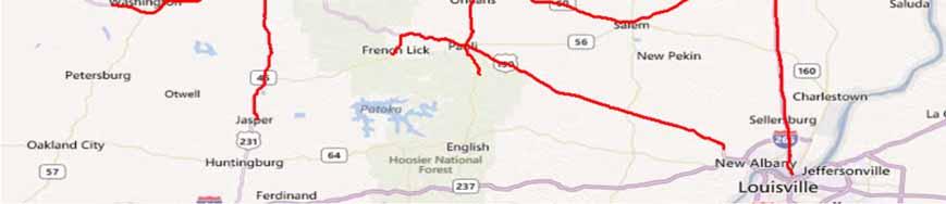
14 Acquired DOT Data (to date)
15 Supplemental Data
16 # Item Category Anticipated NDS Site Coverage Cost to acquire/integrate NY FL PA IN NC WA 1 Crash Data Common All Traffic Information - AADT Safety All Work Zone Common Partial Winter Road Conditions (DOT) Common Partial Local Climatological Data (LCD) NOAA Common All Nonrecurring Congestion Reliability Partial Travel Time Data Reliability Partial Aerial Imagery Common All Speed Limit Data Safety All Speed Limit Laws Policy All Cell phone and text messaging laws Policy All Automated enforcement laws Policy All Alcohol-Impaired and Drugged Drivers laws Policy All A blank does not mean that an item will not be acquired. KEY: Anticipated costs/effort to acquire and integrate: No information 1. 0 Low Medium High
17 # Item Category Anticipated NDS Site Coverage Cost to acquire/integrate NY FL PA IN NC WA 14 Graduated driver licensing (GDL) laws Policy All State motor cycle helmet use laws Policy All Seat Belt Use laws Policy All Cooperative Weather Observer/Other Sources Common All Traffic Data - Continuous Counts (ATR) Safety Partial Traffic Data -Short Duration Counts Safety Partial Automated Enforcement Safety Partial Changes to existing infrastructure condition Safety Partial Roadway Capacity Improvements Common Partial Innovative Treatments Safety Partial Information Common Partial Recurring Congestion Reliability Partial 2.0 KEY: Anticipated costs/effort to acquire and integrate: No information 1. 0 Low Medium High
18 Mobile Data Collection
19 Mobile Data Scope: Approximately 25,000 collection miles in the 6 NDS sites Method: Instrumented Van (Fugro- Roadware)
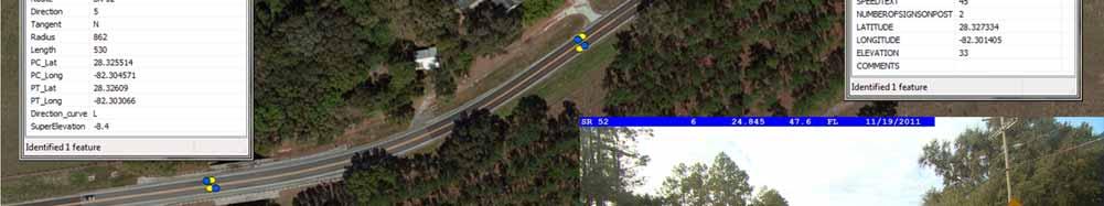
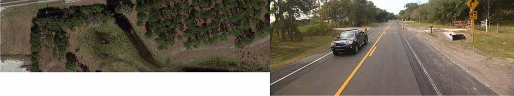
20 Mobile Data Data Element Curvature Length Curvature Radius PC/PT Grade (+ or ) and Cross Slope/Super Elevation Lane Width/Type Paved Shoulder Width/Type Speed Limit Signs (location) Intersection Information Presence of Lighting/Medians/Rumble Strips Front ROW Video Log

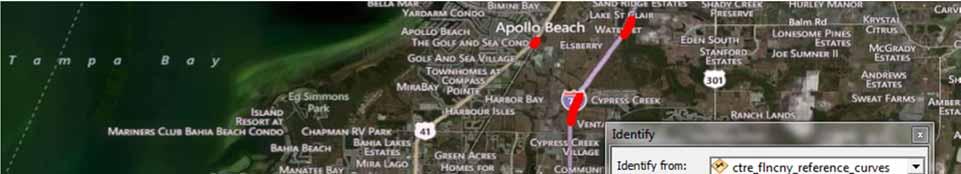
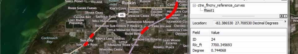
21 Mobile Data Collection Data Collection Plan Which roads to collect? Routing: Maximize collection to match where the NDS participants are driving Not just 1 driver Worked with VTTI to get GPS traces

22 Traces from VTTI (NC)
23 Mobile Data Collection NY: 520 collection miles NC: 615 collection miles FL: 705 collection miles A total of about 1,840 miles

24 Mobile Data Collection Developed routing plans for: NC: FL: WA: NY: IN: 3,200 miles 3,600 miles 4,160 miles 3,200 miles 2,900 miles 2012 collection started in NC and FL in June and was completed in October


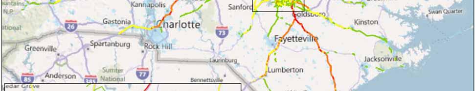
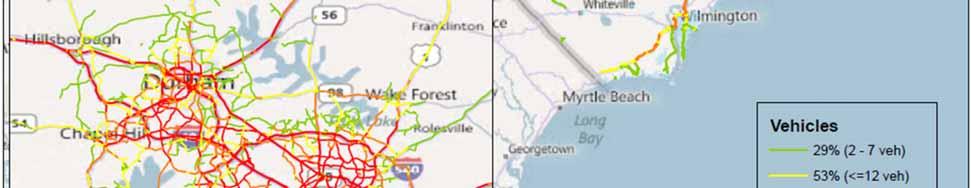
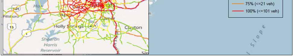
25 North Carolina 615 miles in miles in % Urban 72% Rural


26 Florida Blue: Collected in 2011 Red: proposed for miles in miles in % Urban 40% Rural
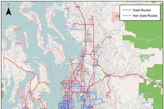
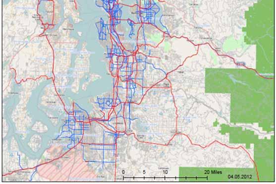

27 Washington 4160 miles in % Urban 28% Rural


28 New York Blue: Collected in 2011 Red: proposed for miles in ,300 miles in % Urban 70% Rural


29 Indiana 2,900 miles in % Urban 67% Rural
30
31 Lighting: N/A Rumble Strips: N/A Unpaved Shoulder: N/A Grade, Cross Slope Paved Shoulder 3 Mix/Combo N/A 3 Mix/Combo 4 Mix/Combo Median Flush Paint. N/A Flush (Painted) N/A Flush (Painted) N/A Flush Paint. Lanes Thru Lane: 1 (12 ) Thru Lane: 1 (11 ) Right Turn: 1 Thru Lane: 1 (12 ) Flush Paint. Lanes Median Thru Lane: 1 (12 ) Left Turn Lane: 1 Thru Lane: 1 (14 ) Deccel. Lane: 1 Thru Lane: 2 (11 ) Deccel. Lane: 1 Thru Lane: 1 (12 ) Accel. Lane: 1 N/A Flush (Painted) N/A Flush (Painted) N/A Thru Lane: 1 (21 ) Flush Paint. Paved Shoulder 2 Mix/Combo 0 Mix/Combo 3 Mix/Combo 2 Mix/Combo Grade, Cross Slope Unpaved Shoulder: N/A Rumble Strips: N/A Lighting: N/A


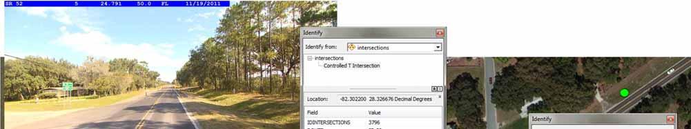
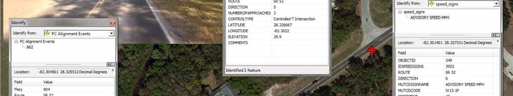
32 Front ROW Images Route Name Direction Chainage State Collection Date
33


34 Data Linking Roadway Information Database NDS Database


35 SHRP 2 S-04A Roadway Information Database Development and Technical Coordination and Quality Assurance of the Mobile Data Collection Project (S04B)
Background. Speed Prediction in Work Zones Using the SHRP 2 Naturalistic Driving Study Data
 Speed Prediction in Work Zones Using the SHRP 2 Naturalistic Driving Study Data Minnesota Towards Zero Deaths Conference October 2017 Shauna Hallmark, Amrita Goswamy, Omar Smadi, Sue Chrysler Background
Florida Strategic Highway Safety Planning Florida Strategic Highway Safety Plan (SHSP) Update and Performance Overview
 Update and Performance Overview") Session 1 Florida Strategic Highway Safety Planning Florida Strategic Highway Safety Plan (SHSP) Update and Performance Overview Joe Santos, PE, FDOT, State Safety Office October, 23, 2013 Florida Statistics
Session 1 Florida Strategic Highway Safety Planning Florida Strategic Highway Safety Plan (SHSP) Update and Performance Overview Joe Santos, PE, FDOT, State Safety Office October, 23, 2013 Florida Statistics
Federal Motor Carrier Safety Administration
 Federal Motor Carrier Safety Administration Earl Hardy Senior Policy Advisor Office of the Assistant Administrator and Chief Safety Officer 2 Who We Are FMCSA Regulates 551,000 active motor carriers 13,000
TRANSPORTATION RESEARCH BOARD. TRB Straight to Recording for All. Rumble Strips/Stripes: Practices and Challenges
 TRANSPORTATION RESEARCH BOARD TRB Straight to Recording for All Rumble Strips/Stripes: Practices and Challenges NCHRP Synthesis Report 490: Practice of Rumble Strips and Rumple Stripes NCHRP Project 20-05,
Regulatory Parking Signs Inventory and Parking Space Count RFP
 Regulatory Parking Signs Inventory and Parking Space Count RFP RFP-2018-04 Questions and Answers 1. What is the desired horizontal accuracy desired for the GPS coordinates 1-3, 5-10, < 30? GPS Coordinates
GIS-Based Safety Bus Stops Serdang and Seri Kembangan Case Study
 GIS-Based Safety Bus Stops Serdang and Seri Kembangan Case Study Khaled Hazaymeh University Putra Malaysia Abstract Enhancing a bus transit system is a possible solution to the growth of congestion in
1400 MISCELLANEOUS Traffic Engineering Manual
 TABLE OF CONTENTS Part 14 - MISCELLANEOUS 1400 GENERAL... 14-3 1415 RUMBLE STRIPS (INCLUDING STRIPES) IN THE ROADWAY... 14-4 1415-1 General... 14-4 1415-2 Transverse Rumble Strips... 14-4 1415-2.1 General...
NCDOT Report on Improving Safety on Secondary Roads
 April 8, 2016 NCDOT Report on Improving Safety on Secondary Roads Kevin Lacy, PE, State Traffic Engineer Overview Crash data and Safety Performance on Secondary Roads Driver Behavior Roadway Environment
Future Vehicle Safety: Connected, Cooperative, or Autonomous? Christopher Poe, Ph.D., P.E. Assistant Agency Director
 Future Vehicle Safety: Connected, Cooperative, or Autonomous? Christopher Poe, Ph.D., P.E. Assistant Agency Director TexITE Meeting August 30, 2012 Presentation Outline Connected Vehicle Program Connected
APPENDIX C1 TRAFFIC ANALYSIS DESIGN YEAR TRAFFIC ANALYSIS
 APPENDIX C1 TRAFFIC ANALYSIS DESIGN YEAR TRAFFIC ANALYSIS DESIGN YEAR TRAFFIC ANALYSIS February 2018 Highway & Bridge Project PIN 6754.12 Route 13 Connector Road Chemung County February 2018 Appendix
TTI TRAFFIC SAFETY CONFERENCE. John A. Barton, P.E.
 TTI TRAFFIC SAFETY CONFERENCE John A. Barton, P.E. Introduction TxDOT Mission Work with others to provide safe and reliable transportation solutions for Texas. 2 Mission Zero Is a Journey toward: Zero
TOWARD SAFE AND RELIABLE ROADWAYS. Jill Ryan, MPH Eagle County Commissioner
 TOWARD SAFE AND RELIABLE ROADWAYS Jill Ryan, MPH Eagle County Commissioner Where Does CDOT Money Go? FY2012 (in CDOT millions) Expenditures $1,104,588,163* $684.3 [63%] MAINTAIN What We Have 15% 14% 5%
EXCEPTION TO STANDARDS REPORT
 EXCEPTION TO STANDARDS REPORT PROJECT DESCRIPTION AND NEED The project is located in Section 6, Township 23 North, Range 9 East and Section 31 Township 24 North, Range 9 East, in the Town of Stockton,
Collect and analyze data on motorcycle crashes, injuries, and fatalities;
 November 2006 Highway Safety Program Guideline No. 3 Motorcycle Safety Each State, in cooperation with its political subdivisions and tribal governments and other parties as appropriate, should develop
AusRAP assessment of Peak Downs Highway 2013
 AusRAP assessment of Peak Downs Highway 2013 SUMMARY The Royal Automobile Club of Queensland (RACQ) commissioned an AusRAP assessment of Peak Downs Highway based on the irap protocol. The purpose is to
S06 Update 7th SHRP 2 Safety Research Symposium Washington, DC July 12, Driving Transportation with Technology VTTI 7/12/2012 1
 S06 Update 7th SHRP 2 Safety Research Symposium Washington, DC July 12, 2012 1 Executive Overview: Original NDS Targets Largest Naturalistic Driving Study Ever Undertaken ca. 3,100 primary drivers, all
Course Syllabus. Time Requirements. Course Timeline. Grading Policy. Contact Information Online classroom Instructor: Kyle Boots
 Course Syllabus Course Overview This course is designed to meet the classroom requirement of your driver s education experience. It is approved by the State of Indiana. Time Requirements The State of Indiana
Work Zone Safety & New Interstate Resurfacing Provision
 2017 CAPA Presentation Work Zone Safety & New Interstate Resurfacing Provision Steve Kite, PE State Work Zone Engineer Work Zone Safety Data In 2016, Approximately 600 construction projects across NC (not
Variable Speed Limit Pilot Project in BC
 Variable Speed Limit Pilot Project in BC Road Safety Engineering Award Nomination Project Description and Road Safety Benefits British Columbia is unique in its challenges. The highways network has more
Understanding and Identifying Crashes on Curves for Safety Improvement Potential in Illinois
 Understanding and Identifying Crashes on Curves for Safety Improvement Potential in Illinois Priscilla Tobias, P.E. Mouyid Islam, Ph.D. Kim Kolody, P.E. Optional Agenda Image Title Background Workflow
I-95 Corridor-wide safety data analysis and identification of existing successful safety programs. Traffic Injury Research Foundation April 22, 2010
 I-95 Corridor-wide safety data analysis and identification of existing successful safety programs Traffic Injury Research Foundation April 22, 2010 Overview Background Methodology Purpose Crash analysis
Defensive Driving Training
 Defensive Driving Training Department of Administrative Services Loss Control Services Why is this training presentation needed? Because people like this are taking their Driver s Test. Customer was on
Naturalistic Drive Cycles Analysis and Synthesis for Pick-up Trucks. Zifan Liu Dr. Andrej Ivanco Dr. Zoran Filipi
 Naturalistic Drive s Analysis and Synthesis for Pick-up Trucks Zifan Liu Dr. Andrej Ivanco Dr. Zoran Filipi Introduction to CU-ICAR Greenville, South Carolina 95% of students gainfully employed in the
Alberta Infrastructure HIGHWAY GEOMETRIC DESIGN GUIDE AUGUST 1999
 &+$37(5Ã)Ã Alberta Infrastructure HIGHWAY GEOMETRIC DESIGN GUIDE AUGUST 1999 &+$37(5) 52$'6,'()$&,/,7,(6 7$%/(2)&217(176 Section Subject Page Number Page Date F.1 VEHICLE INSPECTION STATIONS... F-3 April
Conventional Approach
 Session 6 Jack Broz, PE, HR Green May 5-7, 2010 Conventional Approach Classification required by Federal law General Categories: Arterial Collector Local 6-1 Functional Classifications Changing Road Classification
Act 229 Evaluation Report
 R22-1 W21-19 W21-20 Act 229 Evaluation Report Prepared for Prepared by Table of Contents 1. Documentation Page 3 2. Executive Summary 4 2.1. Purpose 4 2.2. Evaluation Results 4 3. Background 4 4. Approach
SUCCESSFUL PERFORMANCE PAVEMENT PROJECTS 2015 TxAPA Annual Meeting September 23, 2015 Austin District Mike Arellano, P.E. Date
 SUCCESSFUL PERFORMANCE PAVEMENT PROJECTS 2015 TxAPA Annual Meeting September 23, 2015 Austin District Mike Arellano, P.E. Date AUSTIN DISTRICT SAFETY PERFORMANCE OF HIGH- FRICTION MIXTURES Mike Arellano,
Agenda. Puerto Rico s Highway System. An Overview of Puerto Rico
 Motorcycle Crashes and its Implications to Local Roads Dr. Alberto Figueroa Dr. Benjamin Colucci University of Puerto Rico at Mayagüez Puerto Rico LTAP Southeast Local Roads Conference (SELRC) Orange Beach,
2017 MDTSEA Manual - How it Corresponds to the ADTSEA 3.0 Curriculum for Segment 1 and 2 Classroom Education
 2017 MDTSEA - How it Corresponds to the ADTSEA 3.0 Curriculum for Segment 1 and 2 Classroom Education Section 5A Segment 1 Classroom Content, Objectives, and Resources 1 Introduction to Novice Driver Responsibilities
Median Barriers in North Carolina
 Median Barriers in North Carolina AASHTO Subcommittee on Design - 2006 June 13-16, 2006 Jay A. Bennett North Carolina DOT State Roadway Design Engineer Brian Murphy, PE Traffic Safety Engineer Safety Evaluation
Pavement Surface Properties Consortium Phase II (TPF-5[345])
![Pavement Surface Properties Consortium Phase II (TPF-5[345])](/thumbs/92/109191131.jpg "Pavement Surface Properties Consortium Phase II (TPF-5[345])") Pavement Surface Properties Consortium Phase II (TPF-5[345]) OBJECTIVES A research program focused on enhancing the level of service provided by the roadway transportation system through optimized pavement
Pavement Surface Properties Consortium Phase II (TPF-5[345]) OBJECTIVES A research program focused on enhancing the level of service provided by the roadway transportation system through optimized pavement
s Contact the Area Construction Engineer at for RAP sample location. Page 2 of 10
 Page 1 of 10 Page 2 of 10 Page 3 of 10 Ú City limit or Urban boundary No Centerline rumble strips Centerline rumble strips City connecting link or Urbanized (Unincorporated city) TYPICAL CITY CONNECTING
Leading the way to seamless mobility November th, 2017 Tampa, Florida
 Leading the way to seamless mobility November 14-15 th, 2017 Tampa, Florida usa.siemens.com/intelligenttraffic Urban mobility challenges A view on safety and congestion Trend Challenges + 2 Cities grow
Automated Vehicle Research
 Automated Vehicle Research Advancing Transportation through Innovation Andy Schaudt, M.S., M.B.A. Project Director, Automated Vehicle Systems June 20 th Chattanooga, TN It s not just a motto We are innovators
Textbook Alignment to the Advanced Placement (AP) Environmental Science Course Description
 Environmental Science Course Description") Textbook Alignment to the Advanced Placement (AP) Environmental Science Course Description This alignment has been completed using an Independent Alignment Vendor from the USOE approved list (www.schools.utah.gov/curr/imc/indvendor.html.)
Textbook Alignment to the Advanced Placement (AP) Environmental Science Course Description This alignment has been completed using an Independent Alignment Vendor from the USOE approved list (www.schools.utah.gov/curr/imc/indvendor.html.)
The Role of Intelligent Transport Systems in Road Safety and Logistics
 The Role of Intelligent Transport Systems in Road Safety and Logistics Mike van Tonder Aurecon and President ITS SA PRESENTATION CONTENT 1. What are Intelligent Transport Systems (ITS)? 2. What Types of
Activity-Travel Behavior Impacts of Driverless Cars
 January 12-16, 2014; Washington, D.C. 93 rd Annual Meeting of the Transportation Research Board Activity-Travel Behavior Impacts of Driverless Cars Ram M. Pendyala 1 and Chandra R. Bhat 2 1 School of Sustainable
FHWA Motorcycle Crash Causation Study
 Office of Safety Research and Development FHWA Motorcycle Crash Causation Study Carol H. Tan, Ph.D Office of Safety Research & Development 2017 SMSA Sept 28, 2017 1 Presentation Overview Background Data
ODOT Transportation Safety. It All Starts With Crash Data
 ODOT Transportation Safety Programs It All Starts With Crash Data Robin Ness, Mgr. Crash Analysis & Reporting Unit Oregon Department of Transportation (ODOT) 17 th Annual Northwest Tribal Symposium Red
Traffic Safety Facts 2002
 DOT HS 89 616 U.S. Department of Transportation National Highway Traffic Safety Administration Traffic Safety Facts 22 A Public Information Fact Sheet on Motor Vehicle and Traffic Safety Published by the
SCRIM Friction Testing in the USA. Edgar de León Izeppi, Research Scientist Virginia Tech Transportation Institute Nashville, October 13 th 2,016
 SCRIM Friction Testing in the USA Edgar de León Izeppi, Research Scientist Virginia Tech Transportation Institute Nashville, October 13 th 2,016 Outline Introduction: What is the SCRIM? Background and
COUNTERMEASURES THAT WORK:
 COUNTERMEASURES THAT WORK: A HIGHWAY SAFETY COUNTERMEASURE GUIDE FOR STATE HIGHWAY SAFETY OFFICES NINTH EDITION, 2017 AT A GLANCE SUMMARY DOCUMENT ACCESS THE FULL REPORT HERE: Richard, C. M., Magee, K.,
2016 Community Report New Mexico
 216 Produced for the Department of Transportation, Traffic Safety Division, Traffic Records Bureau, Under Contract 581 by the University of, Geospatial and Population Studies, Traffic Research Unit Distributed
HIGHWAY SAFETY RESEARCH GROUP. Safety Analysis Tools Used for Coalitions and Districtwide Safety Investment Plans
 Safety Analysis Tools Used for Coalitions and Districtwide Safety Investment Plans 3 Levels of Analysis SHSP Dashboards LOSS Dashboard GIS Tool SHSP Dashboards Strategic Highway Safety Plan The vision
TRAFFIC SAFETY FACTS Fatal Motor Vehicle Crashes: Overview. Research Note. DOT HS October 2017
 TRAFFIC SAFETY FACTS Research Note DOT HS 812 456 October 2017 2016 Fatal Motor Vehicle Crashes: Overview There were 37,461 people killed in crashes on U.S. roadways during 2016, an increase from 35,485
Overview. Prioritization of Safety Strategies Development of the Minnesota Sinusoidal Rumble Strip Implementation and Public Relations Considerations
 Victor Lund, PE, Traffic Engineer St. Louis County, Minnesota October 11, 2018 Overview Prioritization of Safety Strategies Development of the Minnesota Sinusoidal Rumble Strip Implementation and Public
2015 Community Report White Rock
 5 White Rock Produced for the New Mexico Department of Transportation, Traffic Safety Division, Traffic Records Bureau, Under Contract 58 by the University of New Mexico, Geospatial and Population Studies,
Florida s Turnpike Enterprise. Incident Management Program for All Levels & Specialty Towing & Roadside Repair (STARR)
") Florida s Turnpike Enterprise Incident Management Program for All Levels & Specialty Towing & Roadside Repair (STARR) Florida s Turnpike System Largest Toll System in Florida 460 Centerline Miles 2 Million
Florida s Turnpike Enterprise Incident Management Program for All Levels & Specialty Towing & Roadside Repair (STARR) Florida s Turnpike System Largest Toll System in Florida 460 Centerline Miles 2 Million
2016 Community Report Los Alamos County
 6 Los Alamos County Produced for the New Mexico Department of Transportation, Traffic Safety Division, Traffic Records Bureau, Under Contract 58 by the University of New Mexico, Geospatial and Population
2014 Community Report Portales
 4 Portales Produced for the New Mexico Department of Transportation, Traffic Safety Division, Traffic Records Bureau, Under Contract 58 by the University of New Mexico, Geospatial and Population Studies,
To: File From: Adrian Soo, P. Eng. Markham, ON File: Date: August 18, 2015
 Memo To: From: Adrian Soo, P. Eng. Markham, ON : 165620021 Date: Reference: E.C. Row Expressway, Dominion Boulevard Interchange, Dougall Avenue Interchange, and Howard 1. Review of Interchange Geometry
2016 Community Report Portales
 6 Portales Produced for the New Mexico Department of Transportation, Traffic Safety Division, Traffic Records Bureau, Under Contract 58 by the University of New Mexico, Geospatial and Population Studies,
2014 Community Report Luna County
 4 Luna County Produced for the New Mexico Department of Transportation, Traffic Safety Division, Traffic Records Bureau, Under Contract 58 by the University of New Mexico, Geospatial and Population Studies,
2016 Community Report Torrance County
 6 Torrance County Produced for the New Mexico Department of Transportation, Traffic Safety Division, Traffic Records Bureau, Under Contract 58 by the University of New Mexico, Geospatial and Population
2015 Community Report Torrance County
 5 Torrance County Produced for the New Mexico Department of Transportation, Traffic Safety Division, Traffic Records Bureau, Under Contract 58 by the University of New Mexico, Geospatial and Population
2015 Community Report Grants
 5 Grants Produced for the New Mexico Department of Transportation, Traffic Safety Division, Traffic Records Bureau, Under Contract 58 by the University of New Mexico, Geospatial and Population Studies,
An Introduction to Automated Vehicles
 An Introduction to Automated Vehicles Grant Zammit Operations Team Manager Office of Technical Services - Resource Center Federal Highway Administration at the Purdue Road School - Purdue University West
DEPARTMENT OF TRANSPORTATION OVERVIEW OF SAFETY PROGRAMS
 DEPARTMENT OF TRANSPORTATION OVERVIEW OF SAFETY PROGRAMS SAFETY PROGRAMS Federal Motor Carrier Safety Administration (FMCSA) Commercial Vehicle Safety Federal Highway Administration (FHWA ) Highway Safety
2016 Community Report De Baca County
 6 De Baca County Produced for the New Mexico Department of Transportation, Traffic Safety Division, Traffic Records Bureau, Under Contract 58 by the University of New Mexico, Geospatial and Population
National Center for Statistics and Analysis Research and Development
 U.S. Department of Transportation National Highway Traffic Safety Administration DOT HS 809 271 June 2001 Technical Report Published By: National Center for Statistics and Analysis Research and Development
AUTONOMOUS VEHICLES AND THE TRUCKING INDUSTRY
 AUTONOMOUS VEHICLES AND THE TRUCKING INDUSTRY Presentation for the Maine State Agencies Working Group on Connected and Autonomous Vehicles August 14, 2017 Brian Parke bparke@mmta.com Tim Doyle timd@mmta.com
US 29 Bus Rapid Transit Planning Board Briefing. February 16, 2017
 US 29 Bus Rapid Transit Planning Board Briefing February 16, 2017 Project Goals Improve the quality of transit service Improve mobility opportunities and choices Enhance quality of life Support master
NORTH HOUSTON HIGHWAY IMPROVEMENT PROJECT (NHHIP): SEGMENT 3. April 19, 2018 NHHIP April 19, 2018
: SEGMENT 3. April 19, 2018 NHHIP April 19, 2018") NORTH HOUSTON HIGHWAY IMPROVEMENT PROJECT (NHHIP): SEGMENT 3 April 19, 2018 NHHIP OVERVIEW NHHIP divided into 3 Segments: Segment 1: I-45: Beltway 8 to I-610 (9 mi) 45 Segment 2: I-45: I-610 to I-10 (3
NORTH HOUSTON HIGHWAY IMPROVEMENT PROJECT (NHHIP): SEGMENT 3 April 19, 2018 NHHIP OVERVIEW NHHIP divided into 3 Segments: Segment 1: I-45: Beltway 8 to I-610 (9 mi) 45 Segment 2: I-45: I-610 to I-10 (3
COMMUNITY ENGAGEMENT STRATEGIES
 COMMUNITY ENGAGEMENT STRATEGIES for Teen Driver Safety Parent Awareness Programs Chief Steve Mortenson Elko New Market Police Department Trooper Joe Dellwo Minnesota State Patrol Gordy Pehrson DPS Office
2015 Community Report Las Vegas
 5 Las Vegas Produced for the New Mexico Department of Transportation, Traffic Safety Division, Traffic Records Bureau, Under Contract 58 by the University of New Mexico, Geospatial and Population Studies,
The major roadways in the study area are State Route 166 and State Route 33, which are shown on Figure 1-1 and described below:
 3.5 TRAFFIC AND CIRCULATION 3.5.1 Existing Conditions 3.5.1.1 Street Network DRAFT ENVIRONMENTAL IMPACT REPORT The major roadways in the study area are State Route 166 and State Route 33, which are shown
2014 Community Report Las Vegas
 4 Las Vegas Produced for the New Mexico Department of Transportation, Traffic Safety Division, Traffic Records Bureau, Under Contract 58 by the University of New Mexico, Geospatial and Population Studies,
Purpose and Need Report
 Purpose and Need Report State Highway (SH) 29 From Southwestern Boulevard to SH 95 Williamson County, Texas (CSJ: 0337-02-045) Prepared by Blanton & Associates, Inc. Date: November, 2015 The environmental
2014 Community Report Truth or Consequences
 4 Truth or Consequences Produced for the New Mexico Department of Transportation, Traffic Safety Division, Traffic Records Bureau, Under Contract 58 by the University of New Mexico, Geospatial and Population
2015 Community Report Tularosa
 5 Tularosa Produced for the New Mexico Department of Transportation, Traffic Safety Division, Traffic Records Bureau, Under Contract 58 by the University of New Mexico, Geospatial and Population Studies,
2016 Community Report Santa Fe County
 26 Santa Fe County Produced for the New Mexico Department of Transportation, Traffic Safety Division, Traffic Records Bureau, Under Contract 58 by the University of New Mexico, Geospatial and Population
2014 Community Report Tularosa
 4 Tularosa Produced for the New Mexico Department of Transportation, Traffic Safety Division, Traffic Records Bureau, Under Contract 8 by the University of New Mexico, Geospatial and Population Studies,
Highway 18 BNSF Railroad Overpass Feasibility Study Craighead County. Executive Summary
 Highway 18 BNSF Railroad Overpass Feasibility Study Craighead County Executive Summary October 2014 Highway 18 BNSF Railroad Overpass Feasibility Study Craighead County Executive Summary October 2014 Prepared
Safety Assessment. Intersection of Route 29 (Seminole Trail) and Ashwood Blvd (Route 1670). Albemarle County
 and Ashwood Blvd (Route 1670). Albemarle County") Safety Assessment for Intersection of Route 29 (Seminole Trail) and Ashwood Blvd (Route 1670). Albemarle County Prepared by: VIRGINIA DEPARTMENT OF TRANSPORTATION Northwestern Regional Operations - Traffic
Safety Assessment for Intersection of Route 29 (Seminole Trail) and Ashwood Blvd (Route 1670). Albemarle County Prepared by: VIRGINIA DEPARTMENT OF TRANSPORTATION Northwestern Regional Operations - Traffic
Crash Reconstruction Crash Report and assessment Road Safety Reviews Road Safety Assessment Case Studies/Evaluation
 Road Assessments Crash Reconstruction Crash Report and assessment Road Safety Reviews Road Safety Assessment Case Studies/Evaluation Crash Reconstruction Illinois State Police Illinois Crash Report Assessment
2016 Community Report San Juan County
 26 San Juan County Produced for the New Mexico Department of Transportation, Traffic Safety Division, Traffic Records Bureau, Under Contract 58 by the University of New Mexico, Geospatial and Population
2015 Community Report San Juan County
 25 San Juan County Produced for the New Mexico Department of Transportation, Traffic Safety Division, Traffic Records Bureau, Under Contract 58 by the University of New Mexico, Geospatial and Population
ACCIDENT MODIFICATION FACTORS FOR MEDIAN WIDTH
 APPENDIX G ACCIDENT MODIFICATION FACTORS FOR MEDIAN WIDTH INTRODUCTION Studies on the effect of median width have shown that increasing width reduces crossmedian crashes, but the amount of reduction varies
AGC/MoDOT Annual COOP Meeting. Safety/Traffic Division & Specialty Contractors/Suppliers Breakout Session. December 5, 2018
 AGC/MoDOT Annual COOP Meeting Safety/Traffic Division & Specialty Contractors/Suppliers Breakout Session December 5, 2018 District Work Zone Review St. Louis June 11-14, 2018 Central July 16-18, 2018 Northeast
2015 Community Report Chaparral
 5 Chaparral Produced for the New Mexico Department of Transportation, Traffic Safety Division, Traffic Records Bureau, Under Contract 58 by the University of New Mexico, Geospatial and Population Studies,
2015 Community Report Doña Ana County
 25 Doña Ana County Produced for the New Mexico Department of Transportation, Traffic Safety Division, Traffic Records Bureau, Under Contract 58 by the University of New Mexico, Geospatial and Population
2016 Community Report Aztec
 Aztec Produced for the New Mexico Department of Transportation, Traffic Safety Division, Traffic Records Bureau, Under Contract 58 by the University of New Mexico, Geospatial and Population Studies, Traffic
2015 Community Report Aztec
 25 Aztec Produced for the New Mexico Department of Transportation, Traffic Safety Division, Traffic Records Bureau, Under Contract 58 by the University of New Mexico, Geospatial and Population Studies,
Metropolitan Freeway System 2013 Congestion Report
 Metropolitan Freeway System 2013 Congestion Report Metro District Office of Operations and Maintenance Regional Transportation Management Center May 2014 Table of Contents PURPOSE AND NEED... 1 INTRODUCTION...
Safety Audits in Iowa
 Safety Audits in Iowa National RSA Peer Exchange April 29-10, 2008 Little Rock, AR Tom Welch, P.E. State Safety Engineer Office of Traffic and Safety Iowa Department of Transportation From 3R to 1R We
2014 Community Report Aztec
 Aztec Produced for the New Mexico Department of Transportation, Traffic Safety Division, Traffic Records Bureau, Under Contract 58 by the University of New Mexico, Geospatial and Population Studies, Traffic
Subarea Study. Manning Avenue (CSAH 15) Corridor Management and Safety Improvement Project. Final Version 1. Washington County.
 Corridor Management and Safety Improvement Project. Final Version 1. Washington County.") Subarea Study Manning Avenue (CSAH 15) Corridor Management and Safety Improvement Project Final Version 1 Washington County June 12, 214 SRF No. 138141 Table of Contents Introduction... 1 Forecast Methodology
Subarea Study Manning Avenue (CSAH 15) Corridor Management and Safety Improvement Project Final Version 1 Washington County June 12, 214 SRF No. 138141 Table of Contents Introduction... 1 Forecast Methodology
THE INTERRELATIONSHIPS BETWEEN SPEED LIMITS, GEOMETRY, AND DRIVER BEHAVIOR
 THE SECOND STRATEGIC HIGHWAY RESEARCH PROGRAM (SHRP 2) IMPLEMENTATION ASSISTANCE PROGRAM (IAP) PHASE 1 THE INTERRELATIONSHIPS BETWEEN SPEED LIMITS, GEOMETRY, AND DRIVER BEHAVIOR Authors Peter T. Savolainen,
Motorcycle Safety Program Assessments
 2015 s Conference 2015 ASK 1 Andrew Krajewski Project Manager, SMSA What is a state motorcycle safety program assessment? An independent review of a state s motorcycle safety efforts NHTSA facilitates
ENTUCKY RANSPORTATION C ENTER
 Research Report KTC-05-39/TA19-05-1F T K ENTUCKY RANSPORTATION C ENTER College of Engineering SOCIO-ECONOMIC ANALYSIS OF FATAL CRASH TRENDS (Final Report) Our Mission We provide services to the transportation
Convergence: Connected and Automated Mobility
 Convergence: Connected and Automated Mobility Peter Sweatman Principal, CAVita LLC, Anaheim CA AASHTO CTE Denver June 19, 2018 1 Agenda New technology in mobility: CV, AV and CAV The transformational dynamic
Engineering Dept. Highways & Transportation Engineering
 The University College of Applied Sciences UCAS Engineering Dept. Highways & Transportation Engineering (BENG 4326) Instructors: Dr. Y. R. Sarraj Chapter 4 Traffic Engineering Studies Reference: Traffic
2015 Community Report Los Lunas
 25 Los Lunas Produced for the New Mexico Department of Transportation, Traffic Safety Division, Traffic Records Bureau, Under Contract 58 by the University of New Mexico, Geospatial and Population Studies,
2014 Community Report Los Lunas
 4 Los Lunas Produced for the New Mexico Department of Transportation, Traffic Safety Division, Traffic Records Bureau, Under Contract 58 by the University of New Mexico, Geospatial and Population Studies,
Fred H. Heery, Sr., P.E.
 Fred H. Heery, Sr., P.E. Deputy State Traffic Operations Engineer Florida Department of Transportation Florida Transportation Builders Association Construction Conference March 20-21, 2012 Florida s sunny
2016 Congestion Report
 2016 Congestion Report Metropolitan Freeway System May 2017 2016 Congestion Report 1 Table of Contents Purpose and Need...3 Introduction...3 Methodology...4 2016 Results...5 Explanation of Percentage Miles
Alberta Speeding Convictions and Collisions Involving Unsafe Speed
 Alberta Speeding Convictions and Collisions Involving Unsafe Speed 2004-2008 Overview This document was prepared under the Alberta Traffic Safety Plan, Strategic Research Plan for 2008-2010, with the objective
Collision Analysis Safety Tables
 Crash Severity Geography of Geography of Time and Date of Crash Conditions Features Features.. Queries Selected: Town(Hartford), Date(Year:All or //05 to 9/7/06), Severity(All), Route Class(Interstate),
Transportation Highway Engineering Conference February 24, 2015
 Transportation Highway Engineering Conference February 24, 2015 Today s Agenda Move Illinois status Jane Addams Memorial (I-90) Rebuilding and Widening Project Building a 21 st century corridor Incorporating
POLICY FOR THE ESTABLISHMENT AND POSTING OF SPEED LIMITS ON COUNTY AND TOWNSHIP HIGHWAYS WITHIN MCHENRY COUNTY, ILLINOIS
 POLICY FOR THE ESTABLISHMENT AND POSTING OF SPEED LIMITS ON COUNTY AND TOWNSHIP HIGHWAYS WITHIN MCHENRY COUNTY, ILLINOIS MCHENRY COUNTY DIVISION OF TRANSPORTATION 16111 NELSON ROAD WOODSTOCK, IL 60098