HUB Bound. Travel Report. January
|
|
|
- Gillian Goodwin
- 5 years ago
- Views:
Transcription


1 HUB Bound Travel Report 2009 January
2 ACKNOWLEDGEMENTS The New York Metropolitan Transportation Council (NYMTC) wishes to thank the following agencies for making this report possible: Port Authority of New York & New Jersey (PANY&NJ) for Holland and Lincoln Tunnels motor vehicle data along with PATH statistics Metropolitan Transportation Authority (MTA) Metro-North Railroad MTA NYC Transit MTA Long Island Rail Road MTA Bus Company New Jersey Transit Amtrak for suburban and intercity rail transit data New York City Department of Transportation (NYCDOT) for motor vehicles, bicycle, Staten Island Ferry, private buses and ferry data Roosevelt Island Operating Corporation of the State of New York for Roosevelt Island tramway data Data Monitoring and Analysis Unit Analyst: Supervisors: Conor Clarke Leokadia Glogowski Munnesh Patel Data set used: October 2009 Date of publication: January 2011 The contents of this report reflect the views of the author, who is solely responsible for the accuracy of the data that is presented. Observations and opinions expressed do not necessarily represent the official views of the funding agencies or the State of New York. This report does not constitute a standard, specification or regulation. Hub Bound Travel Report 2009, New York Metropolitan Transportation Council (NYMTC), Jan The Hub Bound Report 2009 was funded by the Federal Highway Administration and the Federal Transit Administration of the United States Department of Transportation and the New York State Department of Transportation. About NYMTC: The New York Metropolitan Transportation Council (NYMTC) is a regional council of governments that is the collaborative forum for transportation planning for New York City, Long Island and the lower Hudson Valley. The New York Metropolitan Transportation Council assures that no person shall on the grounds of race, color, national origin, or gender, as provided in Title VI of the Civil Rights Act of 1964 and related statutes be excluded from participation in, or be denied the benefits of, or be otherwise subjected to discrimination under any program or activity for which NYMTC received Federal financial assistance. Further, NYMTC incorporates the principles of environmental justice into its policies, planning and project development activities to ensure that there are no inequitable impacts on minority groups and low-income groups throughout the region. NYMTC 199 Water Street, 22 nd Floor New York, NY
3 December 2010 The Hub Bound Report is one of the most popular NYMTC publications, and has been published by various organizations for more than 80 years. It presents a detailed analysis of travel to and from the Manhattan Central Business District (CBD) by both persons and vehicles. The Hub, or CBD, is defined as the portion of Manhattan that is south of 60 th Street. This report is published annually and the current edition contains data for a typical fall business day in The Hub Bound Report 2009 contains data vital for modeling transportation patterns, validating air quality conformity determinations, and supporting regional transportation plans, transportation improvement programs and major investment studies. Planners, academic researchers and decision makers often use this report to understand travel patterns, congestion levels and continually changing patterns of travel and employment in Manhattan s CBD. Joel P. Ettinger Executive Director New York Metropolitan Transportation Council NYMTC 199 Water Street, 22 nd Floor New York, NY
4 This page is intentionally left blank
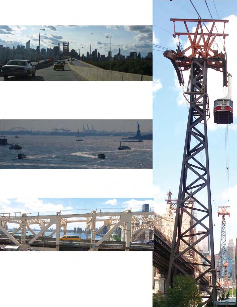
5 MANHATTAN CENTRAL BUSINESS DISTRICT MAP MANHATTAN NEW JERSEY LINCOLN TUNNEL Hudson River W 14 ST 10TH AVE W 23 ST W 42 ST 11TH AVE JOE DIMAGGIO HWY W 34 ST 7TH AVE 8TH AVE 9TH AVE BROADWAY W 60 ST E 60 ST W 57 ST W 48 ST AVE OF THE AMERICAS 5TH AVE PARK AVE LEXINGTON AVE Central Park MADISON AVE E 44 ST 3RD AVE 2ND AVE F D R DRIVE 1ST AVE QUEENS MIDTOWN TUNNEL QUEENSBORO BRIDGE Roosevelt Island QUEENS C B D E 23 ST HOLLAND TUNNEL WEST ST GREENWICH ST HUDSON ST W BROADWAY WALL ST CHURCH ST BLEECKER ST CANAL ST BROADWAY W 4 ST BROOKLYN BRIDGE HOUSTON ST DELANCEY ST ST MARK'S PL E BROADWAY MANHATTAN BRIDGE F D R DRIVE E 14 ST East River WILLIAMSBURG BRIDGE McCarren Park BROOKLYN Upper New York Harbor Governor's Island BROOKLYN BATTERY TUNNEL Ft. Greene Park ¹
6 !!!!!!!!!!!!!!!!!!!!!!!!!!!!!!!!!!!!!!!!!!!!!!!!!!!!!!!!!! MANHATTAN CBD CORDON CROSSINGS BY SECTOR 60TH STREET SECTOR (WEST SIDE) Sixth Avenue Seventh Avenue (IRT) Broadway (BMT) Eighth Avenue (IND) Columbus Avenue Amsterdam Avenue West End Avenue Amtrak Tunnel West Side Highway 60TH STREET SECTOR (EAST SIDE) Fifth Avenue Madison Avenue Park Avenue (Metro-North) Lexington Avenue (IRT) Third Avenue Second Avenue First Avenue York Avenue FDR Drive!!!!!!!!!!!!!!!!!!!!!!!!!!!!!!!!!!!!!!!!!!!!!!!!!!!!!!!!!!!!!!!!!!!!!!!!!!!!!!!!!!!!!!!!!!!!!!!!!!!!!!!!!!!!!!!!!!!!!!!!!!!!!!!!!!!!!!!!!!!!!!!!!!!!!!!!!!!!!!!!!!!!!!!!!!!!!!!!!!!!!!!!!!!!!!!!!!!!!!!!!!!!!!!!!!!!!!!!!!!!!!!!!!!!!!!! QUEENS SECTOR 63rd Street Tunnel (IND) 60th Street Tunnel (BMT/IND) Queensboro Bridge (Tramway) 53rd Street Tunnel (IND) Steinway Tunnel (IRT) Queens-Midtown Tunnel Amtrak/LIRR Tunnels!!!!!!!!!!!!!!!!!!!!!!!!!!!!!!!!!!!!!!!!!!!!!! NEW JERSEY SECTOR Lincoln Tunnel (I-495) Amtrak/NJ Transit Tunnels Uptown Hudson Tubes (PATH) Holland Tunnel (I-78) Downtown Hudson Tubes (PATH) C B D!!!!!!!!!!!!!!!!!!!!!!!!!!!!!!!!!!!!!!!!!!!!!!!!!!!!!!!!!!!!!!!!!!!!!!!!!!!!!!!!!!!!!!!!!!!!!!!!!!!!!!!!!!!!!!!!!!!!!!!!!!!!!!!!!!!!!!!!!!!!!!!!!!!!!!!!!!!!!!!!!!!!!!!!!!!!!!!!!!!! BROOKLYN SECTOR 14th Street Tunnel (BMT) Williamsburg Bridge (BMT) Rutgers Tunnel (IND) Manhattan Bridge (BMT) Brooklyn Bridge Cranberry Tunnel (IND) Clark Tunnel (IRT) Montague Tunnel (BMT) Joralemon Tunnel (IRT) Brooklyn Battery Tunnel (I-478)!!!!!!!!!!!!!! CROSSING TYPE BRIDGE/ ROAD!!!!!! TUNNEL STATEN ISLAND SECTOR Staten Island Ferry!!!!!!!!!!!!!!!!!!!!! ¹ FERRY
7 TABLE OF CONTENTS I Preface... 1 II Highlights... 3 III Changes in Hub Bound Travel... 4 IV Sectors of Entry... 6 A. 60 th Street... 7 B. Brooklyn... 8 C. Queens... 8 D. New Jersey... 8 E. Staten Island... 8 V Mode of Travel... 9 A. Subway B. Bus C. Commuter and Intercity Rail D. Auto, Taxi, Van and Truck E. Bicycle VI Reverse Commute VII Hub Bound Comfort A. Sectors of Entry B. Subway C. Suburban Rail and Bus D. Ferry and Tramway Chart 1 - Persons Entering the Hub by Mode and Year Chart 2 - Persons Entering the Hub by Sector and Year Chart 3 - Persons Entering the Hub by Hour and Mode Chart 4 - Persons Leaving the Hub by Hour and Mode Chart 5 - Private Vehicles Entering the Hub by Hour Chart 6 - Private Vehicles Leaving the Hub by Hour Chart 7 - Hourly Fluctuation of Vehicles Entering and Leaving the Hub Chart 8 - Hourly Accumulation of Vehicles Quick Reference Data: Persons by Mode and Sector Appendix I - Time Series Tables Table 1A - Persons and Vehicles Entering the Hub for Selected Years... I - 1 Table 1B - Morning Peak Period Entry for Selected Years... I - 5 Table 2 - Peak Hour and Peak Period Entry... I - 6 Table 3 - Peak Entry and CBD Employment... I - 7 Table 4 - Cumulative Number of Persons and Motor Vehicles... I - 8 Table 5 - Public Transportation Passengers Entering and Leaving... I - 9 Table 6 - Rail Trains Entering and Leaving... I - 11 Table 7 - Rail Cars Entering and Leaving... I - 12 Table 8 - Public Transportation Level of Comfort during Peak Hour... I - 13
8 Table 9 - Express and Local Buses and Passengers Entering... I - 14 Table 10 - Total Persons Entering and Leaving the Hub by Motor Vehicles... I - 15 Table 11 - Motor Vehicles Entering and Leaving the Hub... I - 16 Table 12 - Hub Reverse Travel during Peak Period... I - 17 Table 13A - Tri-State Region Population... I - 18 Table 13B - Tri-State Region Employment... I - 18 Appendix II - Summary Tables Table 14A - Where, When and How People Entered the Hub 8-9 a.m.... II - 1 Table 14B - Where, When and How People Entered the Hub 7-10 a.m II - 2 Table 14C - Where, When and How People Entered the Hub 24 hour II - 3 Table 15A - Where, When and How People Left the Hub 5-6 p.m... II - 4 Table 15B - Where, When and How People Left the Hub 4-7 p.m II - 5 Table 15C - Where, When and How People Left the Hub 24 hour II - 6 Table 16 - Where and When Motor Vehicles Entered the Hub... II - 7 Table 17 - Where and When Motor Vehicles Left the Hub... II - 8 Table 18 - Where and When Bus Passengers Entered the Hub... II - 9 Table 19 - Where and When Bus Passengers Left the Hub... II - 10 Table 20 - Public Transportation Level of Comfort by Facility and Frequency of Service... II - 11 Table 21A - Total Persons Entering and Leaving the Hub... II - 12 Table 21B - Cumulative number of Persons Entering the Hub... II - 13 Table 22A - Total Public Transport Passengers Entering and Leaving the Hub... II - 14 Table 22B - Cumulative number of Passengers Entering the Hub... II - 15 Table 23A - Total Motor Vehicles Entering and Leaving the Hub... II - 16 Table 23B - Cumulative number of Motor Vehicles Entering the Hub... II - 17 Table 24 - Total Persons Entering the Hub by Hour and Mode... II - 18 Table 25 - Total Persons Leaving the Hub by Hour and Mode... II - 19 Table 26 - Total Persons Entering the Hub by Hour and Sector... II - 20 Table 27 - Total Persons Leaving the Hub by Hour and Sector... II - 21 Appendix III - Hourly Detail Tables Section A - Bus Transit by Sector... III - 1 Section B - Subway by Sector... III - 15 Section C - Suburban and Intercity Rail by Sector... III - 28 Section D - Auto, Taxi and Truck Occupants by Sector... III - 32 Section E - Autos, Taxis, Vans and Trucks by Facility... III - 37 Section F - Ferry and Tramway Passengers by Facility... III - 42 Section G - Bicycle Volumes by Sector... III - 43 Appendix IV - List of Data Sources... IV - 1
9 Summary: The Hub Bound Travel Report has since 1963 documented the number and mode of all travelers entering Manhattan s Central Business District over the course of a single fall business day. The resulting data is grouped by sector of entry, hour, direction, and mode, and provides an essential look at the changing transportation patterns in the NYMTC region. I. PREFACE The first travel survey of the Manhattan Central Business District (CBD) was conducted and published by the Regional Plan Association in The report referred to the district as the Hub, reflecting the CBD s unique role in the region s economy. Subsequent surveys were conducted at eight-year intervals until 1963, when the Tri-State Regional Planning Commission assumed responsibility for the project, publishing it annually beginning in The New York Metropolitan Transportation Council (NYMTC) was created with the dissolution of the Tri-state Regional Planning Commission in 1982, and has sponsored the project and published the report since then. The Hub consists of the lower portion of Manhattan from the northern boundary of 60th Street to the southern boundary of Battery Park. At 8.5 square miles, the land area is less than 0.1% of the NYMTC region s total land area and is home to about 4.9% of the region s residents (Table 13A). The Hub also has one of the highest concentrations of business activity in the nation, hosting about 40% of the region s jobs (Table 13A). While average earnings data specific to the CBD are not available, average earnings in Manhattan are about two times higher than those in the other city boroughs. The New York City subway system has approximately 33 route miles in the Hub. This represents about 13% of the total NYC subway route mileage and 24% of its underground mileage. There are about three route miles of intercity rail in the CBD leading to Penn Station and Grand Central Terminal. For Hub bound travelers using private vehicles, there are approximately 740 off-street parking facilities that can accommodate about 106,000 vehicles. This report provides data and analysis on the numerous transportation services and facilities serving the Hub of the region. It details total travel by mode, time of day, facility, and sector, providing transportation professionals and the general public with a valuable resource for defining the Hub s transportation issues and predicting future demand on the transportation infrastructure. The time series analysis presented in Table 1A contains a useful comparison of current and previous years travel volumes. The report examines travel to and from the Hub by several modes: public transportation, private motor vehicle, and bicycle. Travel via motorcycle, foot and helicopter are not part of this study. The public transit options include the Metropolitan Transportation Authority (MTA) 1
10 New York City Transit subway and bus lines; the Port Authority Trans-Hudson (PATH) subway; MTA Long Island Rail Road (LIRR); MTA Metro-North Railroad (MNR); New Jersey Transit; Amtrak; ferries (both the Staten Island Ferry and privately-owned operations); and the tram run by the Roosevelt Island Operating Corporation of the State of New York. Private vehicle travel includes the use of automobiles, taxis, vans and trucks. The data presented in the report details entry to and exit from the Hub at specific facilities for each hour on a typical fall business day. Most of the data was collected on a business day in October 2009, with the exception of bicycle data, which was collected in September of that year. Both vehicle travel and person travel are shown for all public and private transportation modes. The sectors shown in the tables (60th Street, Queens, Brooklyn, Staten Island and New Jersey) are strictly the entry and exit points in the Hub bound survey and are not necessarily the actual origins or destinations of trips. The analysis based on this data includes changes in Hub bound travel activity over time and changes by sectors of entry and mode of travel. The report also focuses on reverse commuting, including an analysis of travel from the Manhattan CBD during the morning peak hours and to the CBD during the evening peak hours. In addition, it examines the level of comfort offered by public transportation. Estimates rather than actual data were utilized in some instances. This is due to the nature of statistical surveys, particularly one of this magnitude, as well as the loss of NYMTC s archives, files and databases on Sept. 11, The 2009 Hub bound travel data in this report are shown in four appendices: Appendix I presents historical information comparing volumes of travelers and vehicles, employment, population, transit levels of comfort and the cumulative number of people and vehicles in the CBD; Appendix II summarizes the peak hour and peak period figures in each travel mode by facility and sector level, Hub accumulation levels, comfort and headway figures, and sector and mode distributions; Appendix III provides detailed figures for each of the various travel modes addressed in this report. These tables show hourly volumes of travelers and vehicles. The figures are summarized by facility and sector; Appendix IV lists the various public and private agencies that have jurisdiction over travel through the Hub s gateways and have traditionally made their survey data available for this report. 2
11 II. HIGHLIGHTS A total of 3.6 million persons entered New York s Central Business District (CBD) during the course of a given business day in October 2009 (Table 1A). A total of 7.2 million persons entered and left the Manhattan CBD on a given business day in 2009, a decrease of approximately 3.95% compared with 2008 (Table 14 & Table 15). Approximately 37% of persons who entered the CBD did so during the peak period, from 7 am to 10 am (Table 2). Approximately 5.2 million persons entered and left the CBD using public transportation in 2009 about 319,188 or 6.2% less than those who used public transportation in 2008 (Table 5). The total number of people entering and leaving the Hub by autos, taxis, vans and trucks increased by 14,140 (to 1.94 million) over 2008 (Table 10). MTA New York City Transit (NYCT) operates about 79% of the trains entering and leaving the CBD around the clock. During peak periods about 21% of the total trains enter and leave the CBD (Table 6). About 81% of express bus passengers entering the Hub in 2009 came from points west of the Hudson River. About 18.6% of all express bus passengers came from within New York City itself, while the remaining 0.4% traveled from points north of New York City (Table 9). About 47% of all private vehicles (autos, taxis, commuter vans and trucks) entering and leaving the Hub in 2009 did so via the 60th Street sector (all avenues east and west of Central Park including the Central Park Drives). The Brooklyn, Queens and New Jersey sectors accounted for about 24%, 18%, and 12% of the total number of private vehicles, respectively (Table 11). 25% of travelers crossing the CBD boundaries during the morning peak hours (7:00 am - 10:00 am) traveled against the predominant direction of travel. Of these reverse commuters, 56% traveled by subway. Travel contrary to the predominant flow during the evening peak amounted to 32% of travelers, 59% of whom took the subway (Table 24-25). Overall morning reverse travel increased by 3% over the 2008 level (Table 12). The heaviest hour for travel into the CBD in 2009 was 8:00 am - 9:00 am, during which 574,615 persons entered the CBD. Of these, 62% entered via the subway system, while about 11% arrived via private vehicles and 15% via suburban rail (Table 24). Conversely, the heaviest hour of travel out of the CBD was 5:00 pm - 3
12 6:00 pm, during which 444,930 persons left the CBD. Of these, 61% traveled by subway (Table 25). All data were obtained using traditional counting methods and were supplied by the relevant transportations agencies for this report. Motor vehicle occupancy figures (Appendix III Section D) were calculated using occupancy rates from NYMTC s Hub Bound Vehicle Classification and Occupancy Survey conducted in March Due to the loss of NYMTC s files and databases on Sept. 11, 2001, data for 1999 are largely absent. Some sources were able to provide limited data for that year. III. CHANGES IN HUB BOUND TRAVEL In 2009, 3.6 million persons entered the Manhattan CBD on a typical business day (Table 1A). This is 6% less than the highest mark, which was set in 2000 at 3.84 million. Private Transportation In calculating occupancy counts, this report uses the same vehicle occupancy rates that were used in the 2006 Hub Bound Travel Report. These are based on NYMTC s Hub Bound Vehicle Classification and Occupancy Survey for the year In 2009, private transportation brought 26% of all persons into the CBD. This is an increase of 1.3% over 2008, and an absolute increase of about 12,233 persons (Table 14C; Hub Bound Travel Report 2008, Table 14). The total number of people entering and leaving the Hub by private vehicle increased by 0.7%, or 14,140 to 1,936,973 persons. This increase was uneven: the 60 th Street, Brooklyn and Queens sectors all saw increases in private vehicle passengers but their numbers declined in the New Jersey sector. Most of these declines came from the Lincoln Tunnel, whose motor vehicle passenger volume dropped 13.9% (Table 10). Traffic volumes heading to and from Brooklyn increased 1.3% on the Williamsburg Bridge, 2.2% on the Manhattan Bridge, 1% on the Brooklyn Bridge, and 17% through the Brooklyn Battery Tunnel (Table 11). Vehicles traveling to and from Queens increased 2.7% in the Queens Midtown Tunnel and 2.2% on the Queensboro Bridge. 60 th Street traffic increased 2% on the highly trafficked East Side, while remaining nearly unchanged on the West Side (Table11). There were also roughly 42,038 daily bicycle trips taken into and out of the Hub between 6:00 am and midnight in 2009 (Table 14C). 4
13 Persons Entering the Hub by Mode in 2009 (Percentage) Ferry Bicycle 1.4% 0.6% Bus 7.6% Railroad 8.3% Auto 26.4% Subway 55.5% Public Transportation Trips into the Hub made by all modes of public transportation decreased by 7.8% from 2008 levels. Total inbound and outbound public transit trips decreased by 5.8% (Table 22). Bus ridership decreased by 3.5% and subway ridership decreased by 9.2% since 2008 (Table 1A). Downtown and uptown PATH trains carried 5.6% less passengers than in the previous year. Suburban and intercity rail services carried 4.6%, or about 28,181 less passengers than in the prior year. In 2009, the percentage of all public transit passengers entering and leaving the Hub who rode commuter and intercity rail remained at 11% (Table 5). Trips via ferry (both publicly and privately operated) were little changed from 2008 to Figures for the Roosevelt Island Tramway show a 2% increase over 2008 (Table 24; Hub Bound Travel Report 2008, Table 24). 5
14 Cordon Crossings The following are the numbers of travelers who entered the Hub from each sector across the cordon lines that cover its major entry points (Table 1A): Sector of Entry Number of Entries 60th Street sector 1,366,000 Brooklyn sector 944,000 Queens sector 737,000 New Jersey sector 513,000 Staten Island sector 36,000 This report also tracks the maximum net accumulation of persons in the Hub in view of all travel modes. This figure decreased by 9% from the 2008 level to a maximum accumulation of 1.2 million travelers (Tables 21). This remains under the recent peak of 1.5 million persons reached in The report also tracks the time when this maximum accumulation occurs. Historically, more people enter the Hub than leave during the morning hours, while the reverse happens during the late afternoon and early evening hours. Typically, the number of persons accumulating in the Hub reaches a peak sometime in the early afternoon, and 2009 was no exception. From 4:00 am to 2:00 pm, more persons entered the Hub each hour than left. Hence, counts indicated that during the hour from 1:00 pm to 2:00 pm, approximately 1.2 million travelers were in the Hub. During this hour, the number of passengers accumulating via public transportation reached 1.1 million persons. By 1:00 pm, approximately 77,517 motor vehicles had accumulated in the Hub, about 1,681 less than the year before (Tables 21-23). The total number of persons entering the Hub during the morning peak period decreased by 119,896 or 8.29% compared with 2008 (Table 3). IV. SECTORS OF ENTRY Travelers may enter Manhattan s CBD through one of the following five gateways or sectors: 60th Street (Manhattan), Brooklyn, Queens, New Jersey and Staten Island. Travelers from the 60th Street sector may come from upper Manhattan, the Bronx, counties to the north of New York City or from Connecticut, or may have crossed the George Washington Bridge from New Jersey. Travelers arriving from the Brooklyn sector may originate from the borough itself or may be traveling through Brooklyn from Staten Island (via the Verrazano-Narrows Bridge), Queens, Nassau, or Suffolk counties. The Queens sector also includes travelers from Brooklyn, Suffolk or Nassau counties, as well as some arriving across the Whitestone and Throgs Neck 6
15 1,500 Persons Entering the Hub by Sector (Thousands) 1, th St Brooklyn Queens New Jersey Staten Is. Bridges from upstate New York and Connecticut. The New Jersey sector is a gateway for travelers to the CBD from points west of the Hudson River as well as for some Staten Island residents. Staten Island Ferry service is also considered as a separate clearly defined sector not encompassed in the above four sectors. A. 60th Street In 2009, 1.4 million people crossed 60th Street inbound from the north (Table 26). This accounted for 38% of all daily entries into the CBD. About 33% of travelers entering through this sector came in private motor vehicles (autos, taxis, vans and trucks). Subway entry decreased by 11.8% or 101,702 persons compared with 2008, and accounted for 55.4% of this sector s entries. Commuter rail entry decreased by 3.9% (4,102 passengers) and bus transportation decreased by 6.5% (3,015 passengers) compared to Overall, public transportation entries through the 60th Street cordon showed a decrease of 10.2% or 103,959 persons from 2008 to 2009 (Table 14C; Hub Bound Travel Report, 2008, Table 14; Appendix III, Section C). 7
16 B. Brooklyn The number of travelers entering from the Brooklyn sector reached 943,935 in Total public transportation usage decreased by 6.7% or 51,852 passengers when compared to Bus service declined significantly by 17% or 5,264 passengers, while private motor vehicle entries increased 3.2% over 2008 (Table 14C; Hub Bound Travel Report, 2008, Table 14). Surveyed bicycle travel into the Hub increased by 27% and accounted for 6,462 entries daily (Section G; Hub Bound Travel Report, 2008, Section G). C. Queens The total number of passengers arriving from Queens decreased by 41,260, or 5.3%. Public transportation usage increased by 50,197 passengers and accounted for 77% of arrivals, down 2 percentage points since Correspondingly, the share of travelers arriving by private vehicle increased from 20.9% to 23.2%. Subway ridership was down by 9.7% and the relative proportion of bus riders remained unchanged at 2% of all entries (Table 14C; Hub Bound Travel Report, 2008, Table 14). D. New Jersey The number of public transportation commuters who arrived from New Jersey decreased by 6,327, or 1.6% compared with 2008 (Table 14C; Hub Bound Travel Report, 2008, Table 14). Suburban and intercity rail carried in 619 more persons or 0.8% more than the year before (Table C in Appendix III; Hub Bound Travel Report 2008, Table C in Appendix III). PATH passenger volumes decreased by 4.8% from 2008 (Table B in Appendix III; Hub Bound Travel Report, 2008, Table B in Appendix III), and bus ridership remained essentially unchanged. Ferries transported 16,300 persons, a 5.6% decrease from E. Staten Island This report records only the number of entries from Staten Island via the Staten Island Ferry, even though thousands of Staten Islanders also enter the CBD via Brooklyn or New Jersey using other modes of transportation. For the purposes of this survey, they are included in the totals for those sectors as appropriate. Hub bound ferry travel via the Staten Island sector increased by 2.4% or 835 passengers over 2008 (Table 14C; Hub Bound Travel Report, 2008, Table 14). 8
17 V. MODE OF TRAVEL Travelers entering the CBD may choose from a number of public and private forms of transportation. Depending on origin, destination, personal economics, and preference, they may take any (or a combination) of the following modes: subway, bus, suburban and intercity 4,000 Persons Entering the Hub by Mode for Selected Years Persons in Thousands 3,500 3,000 2,500 2,000 1,500 1, Ferry Bus Rail Auto Subway Year rail, private motor vehicle or bicycle. Further possibilities include public and privately operated ferries, as well as the unique Roosevelt Island Tramway. This report does not include data on persons arriving by foot, air, private cruise or commercial ships in the CBD. Subway service is provided by the MTA New York City Transit and Port Authority Trans- Hudson (PATH) systems. Bus service is provided on local and express routes by MTA New York City Transit and by the MTA Bus Company, New Jersey Transit, Westchester County Bee-Line, and by private operators outside of the five boroughs of New York City. Suburban rail service is provided by MTA Metro-North Railroad, MTA Long Island Rail Road, and New Jersey Transit. Intercity rail service is offered by Amtrak to destinations such as Boston, Philadelphia, Washington DC, and Albany. Motor vehicles include private autos, taxis, and private and commercial vans and trucks. This also includes livery service vehicles and commuter vanpools. 9
18 A. Subway The subway system continued to be the most popular mode of public transportation in 2009, carrying a daily average of 2 million passengers into the Hub (Table 1A). That is 76% of all persons entering by way of public transportation. In 2009, the subway system transported 201,000 less passengers into the Hub than in 2008 (Table 1A). Hourly ridership during morning peak hour exceeded average ridership during other hours by five times (Table 14A, 14C). B. Bus Bus service into the Hub is provided primarily by the MTA through its sub-agencies New York City Transit and by the MTA Bus Company. New York City Transit operates nearly all local bus routes in and through the Hub, as well as numerous express routes to and from the outer boroughs. The MTA Bus Company also provides service on express routes in and out of the Hub. These previously privately operated routes were conglomerated under the newly formed MTA Bus Company during 2004 and The Hub Bound Travel Report 2007 is the first NYMTC report with ridership data reflecting the new oversight. As stated previously, this report organizes bus ridership based on the point of entry into the Hub, and not by originating location. In 2009, buses brought 273,766 passengers daily into the Hub (Table 24). Express bus riders from New Jersey accounted for 70% (or 190,548) of all bus passengers entering the Hub (Table 9). Express bus passengers entering through the 60 th Street sector were 3.2% of total bus passengers, those entering through Brooklyn were 9% and those entering through Queens were 4.2% (Appendix III, Section A). C. Commuter and Intercity Rail Commuter and intercity rail trains transported 300,780 passengers, or about 11% of all public transit passenger traffic (Table 14C). That is an 8% share of all persons entering the Hub daily, the same proportion as in This mode experienced a decrease in ridership of 9,485 passengers since 2008 but continues to be the third most popular mode of entry into the Hub (Table 1A; Hub Bound Travel Report, 2008, Table 14, 24). Changes in this mode across sectors from 2008 to 2009 were uneven, with the 60 th Street and Queens sectors absorbing all of the loss in ridership and the New Jersey sector making modest gains. D. Auto, Taxi, Van and Truck Since the first Hub Bound Survey in 1924, private motor vehicles including autos, taxis, vans and trucks have been the second most common mode of transportation behind the subway system. In 2009, 951,151 persons entered the Hub using private motor vehicles. This represents an increase of 12,233 passengers from the previous year (Table 24; Hub Bound Travel Report, 2008, Table 24). 10
19 E. Bicycle In 2009, survey data provided by the New York City Department of Transportation showed nearly 21,792 bicyclists entering the Hub between the hours of 6:00 am and midnight. This represents an increase of nearly 7,040 riders from 2008 (Appendix III, Section G; Hub Bound Travel Report, 2008, Appendix III, Section G). A clear increase in bicycling was also observed during peak hours. The number of bicyclists entering the Hub from all sectors during the morning peak increased by 20% to 4,731 riders. The number of bicyclists from 60 th Street increased by 5 percentage points to 13,294 or 61% of the total, while Brooklyn s share decreased by 5 percentage points to 6,462 or 34% of the total. The share of cyclists entering from Queens remained relatively stable at 12% (Table 14B; Appendix III, Section G; Hub Bound Travel Report, 2008, Appendix III, Section G). Bicyclists on trafficked roads were counted riding either with or against the flow of traffic. The direction of riders on the sidewalk was not recorded, but is interpreted in this report as riding against the flow of traffic. VI. REVERSE COMMUTE 500 Peak Period Reverse Travel by Sector for Selected Years Persons in Thousands New Jersey Queens Brooklyn th St Year 11
20 Reverse commuting refers to travel that leaves the Hub during the morning peak hours and returns during the evening peak. Traffic and transit counts show that this type of travel consistently exceeds baseline ridership during mid-day non-peak hours. Variations in reverse commuter volume can provide information on socioeconomic conditions in the areas bordering the Hub. In 2009, the volume of reverse travelers during the morning peak hours was approximately 433,336 persons (Table 12). They represented 33% of all travel during those hours (Table 12 & Table 1B). VII. HUB BOUND COMFORT For this analysis, the measure of comfort was calculated as the average gross square feet (sq. ft.) per passenger using subways, buses, trains, or the Staten Island Ferry for travel into the Hub during the 8:00 am to 9:00 am peak hour (Table 8). This is tracked because the level of comfort, or crowding, particularly during the peak travel period, is a significant factor influencing a commuter s experience. Additional important factors include: reliability, frequency of service, and the availability of adequate heating or air-conditioning. Providing a sufficient level of comfort on the public transportation system is a major goal of all transportation operators. By this measure, there have been increases in average space per passenger on subways and suburban rail entering through the 60 th Street sector, buses entering through the Brooklyn sector, all public transit modes from the Queens sector, subways from the New Jersey sector and the Roosevelt Island Tramway. Space per passenger declined on buses through 60 th Street, all public transit from Brooklyn, suburban rail from the New Jersey sector and the Staten Island Ferry. Average floor space on buses from New Jersey remained constant (Table 8). Frequency of service, another index of comfort, is also tracked in this report. This is referred to as average headway in minutes, and is calculated as 60 minutes divided by the number of trains entering during the 8:00 am to 9:00 am peak hour. The survey shows that overall service frequency was 2.9 minutes per train, reflecting a very slight decrease in frequency of service on routes serving the hub (Table 20). Frequency of service for buses can be found in Appendix III, Section A. A. Sector of Entry Analysis by sector showed that on average, passengers arriving from Brooklyn lost 0.2 sq. ft. per passenger for an average of 5.5 sq. ft., but experienced very little change in average headway. Passengers entering across 60 th Street and from the Queens sector gained significantly averages of 0.86 sq. ft. and 0.67 sq. ft. per passenger, respectively. New Jersey passengers gained 0.22 sq. ft. per passenger on average (Table 20). 12
21 The Staten Island Ferry remained the roomiest public transportation mode, with an average of sq. ft. per passenger in Information is unavailable for the private ferry operators. Average square footage on the Roosevelt Island Tramway increased moderately from 2008 to 4.34 sq. ft. (Table 20). B. Subway Analysis for this mode of transportation was examined by line. Subways arriving across 60 th Street gained an average of 1 sq. ft. per passenger, or 20% over Passengers on the Lexington Avenue local lines (4 and 6 trains) gained approximately 1.6 sq. ft. per passenger due to an increase in the number of trains, and a decrease of 4,668 passengers. Passengers on the 7 th Avenue local lines (1 and 2 trains) gained approximately 2 sq. ft. per passenger due to a combination of fewer passengers and more trains in that hour. Passengers on the 7 th Avenue express lines gained approximately 1.44 sq. ft. per passenger largely due to a loss of 5,519 riders in that hour. The remainder of the lines crossing into the Hub from 60 th Street each fluctuated within 1 sq. ft. per passenger of their 2008 floor space. The greatest outliers were the 8 th Avenue Express which averaged 4.39 sq. ft. per passenger and the 7 th Avenue Local which averaged 8.91 sq. ft. per passenger. The rest of the lines fell within these values. Average headway on all 60 th Street subways edged up from 3.07 to 3.10 minutes with a range of 2.5 minutes per train for the Lexington Avenue Express (most frequent service) to 5.5 minutes for the 8 th Avenue Local (least frequent service) (Table 20). The Brooklyn sector showed a moderate decrease of 3% in floor space per passenger. Significant changes were observed on the J, Z, and M trains across the Williamsburg Bridge (a gain of 2.09 sq. ft.), the F line through the Rutgers Street Tunnel (a loss of 1.49 sq. ft.), the A and C trains through the Cranberry Street Tunnel (a gain of 1.48 sq. ft.) and the 4 and 5 lines through the Joralemon Street Tunnel (a loss of 1.24 sq. ft.). As is clear, these significant changes generally balanced each other out as far as the sector is concerned (Table 20). The rest of the Brooklyn sector locations showed less dramatic floor space changes. Riders on the N, Q, R and W trains through the Montague Street Tunnel gained around 0.79 sq. ft. per passenger. Riders on the L line (14 th St. Tunnel) gained 0.69 sq. ft. per passenger. Riders the B, D and N trains over the Manhattan Bridge saw essentially no change in floor space (an increase of 0.07 sq. ft. per passenger). And riders on the 2 and 3 lines (Clark St. Tunnel) also saw a modest increase of 0.19 sq. ft. per passenger (Table 20). In terms of absolute comfort, the L line remains the most crowded but is joined by the B, D and N Manhattan bridge lines with only 4.92 and 4.90 sq. ft. per passenger, respectively. At the opposite end, the N, Q, R and W trains remain the most spacious, with an average of 9.12 sq. ft. per passenger. The remaining lines range from 5.32 to 7.66 sq. ft. per passenger (Table 20). Passengers from Queens generally experienced less fluctuation in floor space with the exception of the Steinway Street Tunnel 7 line, which jumped from 7.62 to sq. ft. per passenger. This can be explained by a significant decrease in the number of passengers and a significant increase in the number of trains. The rest of the Queens sector lines experienced changes ranging from 0.01 to 0.80 sq. ft. per passenger (Table 20). 13
22 Statistics show that available floor space on the downtown PATH lines decreased while floor space on the uptown lines increased. Since in 2009, both lines ran the same number of trains and cars, the difference in floor space 5.48 sq. ft. per passenger for the downtown lines and 4.35 for the uptown lines was caused by the greater number of passengers riding the downtown lines. The changes from 2008 were moderate (Table 20). C. Suburban Rail and Bus Fluctuations in average floor space per passenger on suburban rail were generally minor with none greater than 1 sq. ft. per passenger. Commuters from the 60 th Street sector saw an increase of 0.3 sq. ft., those from Queens saw an increase of 0.4 sq. ft. and those from New Jersey saw a decrease of 0.11 sq. ft. per passenger. Floor space per passenger on Queens sector trains, which saw the largest change, a 6% increase, was influenced by both an increase in total floor space and a decrease in passengers (Table 20). The range of average floor space per passenger on buses ranged from 8.51 sq. ft. from the Brooklyn sector, to sq. ft. from north of 60 th Street (Table 20). D. Ferry and Tramway Historically, travelers aboard the Staten Island Ferry have enjoyed the highest floor space per passenger, much more than most of the other mass transportation operators can provide. In 2009, the comfort level was sq. ft. per passenger. Riders on the Roosevelt Island Tramway each received 4.34 sq. ft., up from 4.21 sq. ft. in 2008, due to decreased ridership. No information is available on the various private ferry vessels specifications. 14
23 15
24 4000 CHART 1 PERSONS ENTERING THE HUB BY MODE AND YEAR No. of Persons (in Thousands) Tram and Bicycle Ferry Railroad Subway 1000 Bus 500 Motor Vehicle Year CHART 2 PERSONS ENTERING THE HUB BY SECTOR AND YEAR 4000 No. of Persons (in Thousands) Staten Is. & Roosevelt Is. New Jersey Queens Brooklyn North of 60th Street Year 16
25 CHART 3 PERSONS ENTERING THE HUB BY HOUR AND MODE AUTO/TAXI VAN/TRUCK SUBWAY BUSES 12:00 am 01:00 am SUBURBAN RAIL FERRY TRAM& BICYCLE 02:00 am 03:00 am 04:00 am 05:00 am 06:00am 07:00 am 08:00 am 09:00 am 10:00 am Hour 11:00 am 12:00 pm 01:00 pm 02:00 pm 03:00 pm 04:00 pm 05:00 pm 06:00 pm 07:00 pm 08:00 pm 09:00 pm 10:00 pm 11:00 pm No. of Persons (in Thousands) 17
26 CHART 4 PERSONS LEAVING THE HUB BY HOUR AND MODE 12:00 am AUTO/TAXI VAN/TRUCK SUBWAY BUSES 01:00 am 02:00 am SUBURBAN RAIL FERRY TRAM& BICYCLE 03:00 am 04:00 am 05:00 am 06:00am 07:00 am 08:00 am 09:00 am Hour 10:00 am 11:00 am 12:00 pm 01:00 pm 02:00 pm 03:00 pm 04:00 pm 05:00 pm 06:00 pm 07:00 pm 08:00 pm 09:00 pm 10:00 pm 11:00 pm No. of Persons (in Thousands) 18
27 CHART 5 PRIVATE VEHICLES ENTERING THE HUB BY HOUR FOR YEARS 2007, 2008, :00 am 01:00 am 02:00 am :00 am 04:00 am 05:00 am 06:00am 07:00 am 08:00 am 09:00 am Hour 10:00 am 11:00 am 12:00 pm 01:00 pm 02:00 pm 03:00 pm 04:00 pm 05:00 pm 06:00 pm 07:00 pm 08:00 pm 09:00 pm 10:00 pm 11:00 pm No. of Private Vehicles (in Thousands) 19
28 CHART 6 PRIVATE VEHICLES LEAVING THE HUB BY HOUR FOR YEARS 2007, 2008, :00 am 01:00 am 02:00 am :00 am 04:00 am 05:00 am 06:00am 07:00 am 08:00 am 09:00 am Hour 10:00 am 11:00 am 12:00 pm 01:00 pm 02:00 pm 03:00 pm 04:00 pm 05:00 pm 06:00 pm 07:00 pm 08:00 pm 09:00 pm 10:00 pm 11:00 pm No. of Private Vehicles (in Thousands) 20
29 CHART 7 HOURLY FLUCTUATION OF VEHICLES ENTERING AND LEAVING THE HUB BY HOUR in :00 am No. of Private Vehicles (in Thousands) :00 am 02:00 am Entering 03:00 am 04:00 am Leaving 05:00 am 06:00 am 07:00 am 08:00 am 09:00 am 10:00 am 11:00 am Hour 12:00 pm 01:00 pm 02:00 pm 03:00 pm 04:00 pm 05:00 pm 06:00 pm 07:00 pm 08:00 pm 09:00 pm 10:00 pm 11:00 pm No. of Private Vehicles (in Thousands) 21
30 CHART 8 HOURLY ACCUMULATION OF VEHICLES BY HOUR in 2009 No. of Private Vehicles (in Thousands) :00 am 01:00 am 02:00 am 03:00 am 04:00 am 05:00 am 06:00am 07:00 am 08:00 am 09:00 am 10:00 am 11:00 am Hour 12:00 pm 01:00 pm 02:00 pm 03:00 pm 04:00 pm 05:00 pm 06:00 pm Maximum Accumulation 1PM 07:00 pm 08:00 pm 09:00 pm 10:00 pm 11:00 pm No. of Private Vehicles (in Thousands) 22
31 QUICK REFERENCE DATA Persons Entering and Leaving the Hub by Mode and Sector in 2009 SECTOR / MODE Entering Leaving Total 60TH STREET SUBWAY 756, ,044 1,489,973 AUTOS, TAXIS, VANS AND TRUCKS 450, , ,023 BUS 43,264 44,537 87,801 SUBURBAN AND INTERCITY RAIL 101,670 98, ,396 FERRY BICYCLE 13,294 12,947 26,241 TOTAL 60TH STREET SECTOR - ALL MODES 1,366,185 1,355,334 2,721,519 BROOKLYN SUBWAY 694, ,510 1,371,318 AUTOS, TAXIS, VANS AND TRUCKS 216, , ,663 BUS 25,865 23,803 49,668 SUBURBAN AND INTERCITY RAIL FERRY BICYCLE 6,462 5,561 12,023 TOTAL BROOKLYN SECTOR - ALL MODES 943, ,204 1,884,139 QUEENS (and TRAMWAY) SUBWAY 430, , ,390 AUTOS, TAXIS, VANS AND TRUCKS 171, , ,546 BUS 14,089 11,995 26,084 SUBURBAN AND INTERCITY RAIL 115, , ,674 FERRY BICYCLE 1,810 1,506 3,316 TRAMWAY 3,109 3,091 6,200 TOTAL QUEENS SECTOR - ALL MODES 737, ,115 1,480,265 NEW JERSEY SUBWAY and PATH 111, , ,303 AUTOS, TAXIS, VANS AND TRUCKS 112, , ,741 BUS 190, , ,675 SUBURBAN AND INTERCITY RAIL 83,152 70, ,209 FERRY 16,300 14,799 31,099 BICYCLE TOTAL NEW JERSEY SECTOR - ALL MODES 513, , ,027 STATEN ISLAND (via FERRY) SUBWAY AUTOS, TAXIS, VANS AND TRUCKS BUS (1) SUBURBAN AND INTERCITY RAIL FERRY 36,027 37,119 73,146 BICYCLE TOTAL STATEN ISLAND (via FERRY) 36,253 37,351 73,604 ALL SECTORS SUBWAY 1,993,629 1,958,355 3,951,984 AUTOS, TAXIS, VANS AND TRUCKS 951, ,822 1,936,973 BUS 273, , ,228 SUBURBAN AND INTERCITY RAIL 300, , ,279 FERRY 52,630 52, ,852 BICYCLE 21,792 20,246 42,038 TRAMWAY 3,109 3,091 6,200 TOTAL ALL SECTORS - ALL MODES 3,596,857 3,560,697 7,157,554 23
32 This page is intentionally left blank 24
33 Appendix I Time Series Tables Note: Some data for 1999 were lost on 9/11/01
34 This page is intentionally left blank
35 TABLE 1A PERSONS AND VEHICLES ENTERING THE HUB ON A FALL BUSINESS DAY BY MODE AND BY SECTOR FOR SELECTED YEARS (in thousands) PERSONS BY MODE AUTO, TAXI, VAN & TRUCK % % % % % % % % BUS % % % % % % % % TROLLEY % % % 3 0.1% SUBWAY 1, % 2, % 2, % 1, % 1, % 1, % 1, % 1, % RAILROAD % % % % % % % % PASSENGER FERRY % % % % % % % TOTAL 2,697-3,271-3,691-3,313-3,349-3,290-3,167-3,008 - PERSONS BY SECTOR I - 1 NORTH OF 60TH STREET 1, % 1, % 1, % 1, % 1, % 1, % 1, % 1, % BROOKLYN % 1, % 1, % % % % % % QUEENS % % % % % % % % NEW JERSEY % % % % % % % % STATEN ISLAND % % % % % % % % TOTAL 2,697-3,271-3,691-3,313-3,349-3,290-3,167-3,008 - MOTOR VEHICLES BY SECTOR (AUTOS, TAXIS, VANS, TRUCKS) NORTH OF 60TH STREET % % % % % % % % BROOKLYN % % % % % % % % QUEENS % % % % % % % % NEW JERSEY % % % % % % % % STATEN ISLAND 2 0.7% 1 0.3% 1 0.3% 2 0.4% 2 0.3% 2 0.4% 1 0.2% 1 0.2% TOTAL APPENDIX I- Time Series Tables
36 APPENDIX I- Time Series Tables TABLE 1A (continued) PERSONS AND VEHICLES ENTERING THE HUB ON A FALL BUSINESS DAY BY MODE AND BY SECTOR FOR SELECTED YEARS (in thousands) PERSONS BY MODE AUTO, TAXI, VAN & TRUCK % % 1, % 1, % 1, % 1, % 1, % 1, % BUS % % % % % % % % SUBWAY 1, % 1, % 1, % 1, % 1, % 1, % 1, % 1, % RAILROAD % % % % % % % % PASSENGER FERRY % % % % % % % % TRAM 4 0.1% % 4 0.1% % 4 0% 2 0.1% 1 0.0% TOTAL 3,013-3,074-3,233-3,362-3,392-3,475-3,322-3,335 - PERSONS BY SECTOR I - 2 NORTH OF 60TH STREET 1, % 1, % 1, % 1, % 1, % 1, % 1, % 1, % BROOKLYN % % % % % % % % QUEENS % % % % % % % % NEW JERSEY % % % % % % % % STATEN ISLAND % % % % % % % % ROOSEVELT ISLAND 4 0.1% 4 0.1% 4 0.1% 4 0.1% 3 0.1% 4 0.1% % % TOTAL 3,013-3,074-3,233-3,362-3,392-3,475-3,322-3,336 - MOTOR VEHICLES BY SECTOR (AUTOS, TAXIS, VANS, TRUCKS) NORTH OF 60TH STREET % % % % % % % % BROOKLYN % % % % % % % % QUEENS % % % % % % % % NEW JERSEY % % % % % % % % STATEN ISLAND 1 0.2% 1 0.1% 1 0.1% 1 0.1% 1 0.1% 1 0.1% % - - TOTAL
37 TABLE 1A (continued) PERSONS AND VEHICLES ENTERING THE HUB ON A FALL BUSINESS DAY BY MODE AND BY SECTOR FOR SELECTED YEARS (in thousands) PERSONS BY MODE AUTO, TAXI, VAN & TRUCK 1, % 1, % 1, % 1, % 1, % 1, % 1, % 1, % BUS % % % % % % % % SUBWAY 1, % 1, % 1, % 1, % 1, % 1, % 1, % 1, % RAILROAD % % % % % % % % PASSENGER FERRY % % % % % % % % TRAM 7 0.2% % 2 0.0% 2 0.1% 1 0.1% 1 0.1% 1 0.0% 1 0.0% BICYCLE % % % % TOTAL 3,330-3,382-3,410-3,454-3,546-3,670-3,790-3,839 - PERSONS BY SECTOR I - 3 NORTH OF 60TH STREET 1, % 1, % 1, % 1, % 1, % 1, % 1, % 1, % BROOKLYN % % % % % % % 1, % QUEENS % % % % % % % % NEW JERSEY % % % % % % % % STATEN ISLAND % % % % % % % % ROOSEVELT ISLAND % % % % % % % TOTAL 3,330-3,382-3,410-3,433-3,544-3,669-3,790-3,839 - MOTOR VEHICLES BY SECTOR (AUTOS, TAXIS, VANS, TRUCKS) NORTH OF 60TH STREET % % % % % % % % BROOKLYN % % % % % % % % QUEENS % % % % % % % % NEW JERSEY % % % % % % % % STATEN ISLAND % % % % % % % TOTAL APPENDIX I- Time Series Tables
New York Metropolitan Transportation Council. HUB Bound. Travel Data
 New York Metropolitan Transportation Council HUB Bound Travel Data December 2016 2015 ACKNOWLEDGEMENTS The New York Metropolitan Transportation Council (NYMTC) wishes to thank the following agencies for
NEW YORK METROPOLITAN TRANSPORTATION COUNCIL NEEE. D travel data
 NEW YORK METROPOLITAN TRANSPORTATION COUNCIL NEEE HUB O UN D travel data Acknowledgements The New York Metropolitan Transportation Council (NYMTC) wishes to thank the following agencies for making these
Whither the Dashing Commuter?
 Whither the Dashing Commuter? The MTA in a Changing Region William Wheeler Director of Special Project Development and Planning Travel in the New York Region has changed from the days of the 9 to 5 commute
Congestion Pricing for New York City
 Congestion Pricing for New York City Past (2007-08) Failure, Future (2014-15) Success? Presentation for International Forum on Economic Policies for Traffic Congestion and Tailpipe Emissions 12-13 December
Chapter 9: Transportation (Rail Transit) D. RAIL TRANSIT
 D. RAIL TRANSIT") Chapter 9: Transportation (Rail Transit) D. RAIL TRANSIT EXISTING CONDITIONS The subway lines in the study area are shown in Figures 9D-1 through 9D-5. As shown, most of the lines either serve only portions
Chapter 9: Transportation (Rail Transit) D. RAIL TRANSIT EXISTING CONDITIONS The subway lines in the study area are shown in Figures 9D-1 through 9D-5. As shown, most of the lines either serve only portions
MTA Capital and Planning Review
 MTA Capital and Planning Review The Bond Buyer's 5th Annual Metro Finance Conference November 15, 2007 Evolution of the Capital Plan 1 Plan Evolution First five-year plan approved in 1982 to rescue system
UTA Transportation Equity Study and Staff Analysis. Board Workshop January 6, 2018
 UTA Transportation Equity Study and Staff Analysis Board Workshop January 6, 2018 1 Executive Summary UTA ranks DART 6 th out of top 20 Transit Agencies in the country for ridership. UTA Study confirms
NEW YORK SUBURBAN RAIL SUMMARY (COMMUTER RAIL, REGIONAL RAIL)
") NEW YORK SUBURBAN RAIL SUMMARY (COMMUTER RAIL, REGIONAL RAIL) October 2003 New York: The New York commuter rail service area consists of 20.3 million people, spread over 4,700 square miles at an average
NEW YORK SUBURBAN RAIL SUMMARY (COMMUTER RAIL, REGIONAL RAIL) October 2003 New York: The New York commuter rail service area consists of 20.3 million people, spread over 4,700 square miles at an average
MTA Long Island Rail Road (LIRR) and MTA Metro-North Railroad (MNR) System-wide Service Standards
 and MTA Metro-North Railroad (MNR) System-wide Service Standards") MTA Long Island Rail Road (LIRR) and MTA (MNR) System-wide Service Standards The following system-wide service standards apply to LIRR and MNR operations. 1. Service Availability Service Availability is
MTA Long Island Rail Road (LIRR) and MTA (MNR) System-wide Service Standards The following system-wide service standards apply to LIRR and MNR operations. 1. Service Availability Service Availability is
PHILADELPHIA SUBURBAN RAIL SUMMARY (COMMUTER RAIL, REGIONAL RAIL)
") PHILADELPHIA SUBURBAN RAIL SUMMARY (COMMUTER RAIL, REGIONAL RAIL) October 2003 The Philadelphia commuter rail service area consists of 5.1 million people, spread over 1,800 square miles at an average population
PHILADELPHIA SUBURBAN RAIL SUMMARY (COMMUTER RAIL, REGIONAL RAIL) October 2003 The Philadelphia commuter rail service area consists of 5.1 million people, spread over 1,800 square miles at an average population
Policy Note. Vanpools in the Puget Sound Region The case for expanding vanpool programs to move the most people for the least cost.
 Policy Note Vanpools in the Puget Sound Region The case for expanding vanpool programs to move the most people for the least cost Recommendations 1. Saturate vanpool market before expanding other intercity
Effective June 25, New York City Transit. Subway Timetable
 Effective June 25, 2017 New York City Transit Subway Timetable 1 1 trains operate between Van Cortlandt Park-242 St in the Bronx and South Ferry in Manhattan, all times. Fares All MTA New York City Transit
Bi-County Transitway/ Bethesda Station Access Demand Analysis
 Bi-County Transitway/ Bethesda Station Access Demand Analysis Prepared for: Washington Metropolitan Area Transit Authority Office of Planning and Project Development May 2005 Prepared by: in conjunction
Appendix C Transportation. C-1: Chelsea Market Survey Results C-2: Transportation Demand Factors Memo C-3: Proposed Safety Improvements
 Appendix C Transportation C-1: Chelsea Market Survey Results C-2: Transportation Demand Factors Memo C-3: Proposed Safety Improvements Appendix C-1 Chelsea Market Survey Results CHELSEA MARKET SURVEY
Good morning, Chairman Lautenberg, Ranking Member Wicker, and other members of the Committee.
 1 Testimony of Joseph J. Lhota Chairman and CEO of the New York Metropolitan Transportation Authority to the U.S. Senate Subcommittee on Surface Transportation and Merchant Marine Infrastructure December
QM3. Between Little Neck, Queens, and Midtown, Manhattan. Special Schedule. The Day After Thanksgiving Martin Luther King Day.
 Special Bus Timetable Effective 2018-19 MTA Bus Company Special Schedule The Day After Thanksgiving Martin Luther King Day QM3 Express Service Between Little Neck, Queens, and Midtown, Manhattan If you
National Household Travel Survey Add-On Use in the Des Moines, Iowa, Metropolitan Area
 National Household Travel Survey Add-On Use in the Des Moines, Iowa, Metropolitan Area Presentation to the Transportation Research Board s National Household Travel Survey Conference: Data for Understanding
BROWARD BOULEVARD CORRIDOR TRANSIT STUDY
 BROWARD BOULEVARD CORRIDOR TRANSIT STUDY FM # 42802411201 EXECUTIVE SUMMARY July 2012 GOBROWARD Broward Boulevard Corridor Transit Study FM # 42802411201 Executive Summary Prepared For: Ms. Khalilah Ffrench,
TRAVEL DEMAND FORECASTS
 Jiangxi Ji an Sustainable Urban Transport Project (RRP PRC 45022) TRAVEL DEMAND FORECASTS A. Introduction 1. The purpose of the travel demand forecasts is to assess the impact of the project components
Project Purpose and Need B. IDENTIFICATION OF THE PROPOSED PROJECT
 Chapter 1: Project Purpose and Need A. INTRODUCTION The Federal Transit Administration (FTA) and the Metropolitan Transportation Authority (MTA), in cooperation with MTA New York City Transit (NYCT), propose
Will the L Train Shutdown be a Missed Opportunity or Model for the Future?
 Will the L Train Shutdown be a Missed Opportunity or Model for the Future? Here s how to improve plans for the L train before it s too late The MTA has said it will shutdown the L train for 15 months starting
Necessity or Choice?
 Necessity or Choice? Why People Drive in Manhattan Prepared for Transportation Alternatives February 2006 Schaller Consulting 94 Windsor Place, Brooklyn, NY (718) 768-3487 schaller@schallerconsult.com
Chicago Transit Authority Service Standards and Policies
 Chicago Transit Authority Service Standards and Policies Overview and Objectives The Chicago Transit Authority (CTA) has revised its Service Standards and Policies in accordance with Federal Transit Administration
The Preferred Alternative: a Vision for Growth on the Northeast Corridor
 A Long-Term Vision is Needed The Preferred Alternative: a Vision for Growth on the Northeast Corridor The Federal Railroad Administration (FRA) has released the Tier 1 Final Environmental Impact Statement
2 EXISTING ROUTE STRUCTURE AND SERVICE LEVELS
 2 EXISTING ROUTE STRUCTURE AND SERVICE LEVELS In the Study Area, as in most of the Metro Transit network, there are two distinct route structures. The base service structure operates all day and the peak
Effective June 24, New York City Transit. Subway Timetable
 Effective June 24, 2018 New York City Transit Subway Timetable 7 7 trains operate between Flushing- Main St, Queens, and 34 St- Hudson Yards, Manhattan, at all times. Weekday mornings some 7 trains (denoted
Funding Scenario Descriptions & Performance
 Funding Scenario Descriptions & Performance These scenarios were developed based on direction set by the Task Force at previous meetings. They represent approaches for funding to further Task Force discussion
Submission to Greater Cambridge City Deal
 What Transport for Cambridge? 2 1 Submission to Greater Cambridge City Deal By Professor Marcial Echenique OBE ScD RIBA RTPI and Jonathan Barker Introduction Cambridge Futures was founded in 1997 as a
Introduction and Background Study Purpose
 Introduction and Background The Brent Spence Bridge on I-71/75 across the Ohio River is arguably the single most important piece of transportation infrastructure the Ohio-Kentucky-Indiana (OKI) region.
Bus Congestion on the West Side of Manhattan. 6/6/14 Manha*an Community Baord 4 1
 Bus Congestion on the West Side of Manhattan 6/6/14 Manha*an Community Baord 4 1 Hudson Yards Economic Impact ~120,000 direct jobs (and potential for another 120K of indirect jobs) ~$60B of tax revenue
Abstract. Executive Summary. Emily Rogers Jean Wang ORF 467 Final Report-Middlesex County
 Emily Rogers Jean Wang ORF 467 Final Report-Middlesex County Abstract The purpose of this investigation is to model the demand for an ataxi system in Middlesex County. Given transportation statistics for
The City of Toronto s Transportation Strategy July 2007
 The City of Toronto s Transportation Strategy July 2007 Presentation Outline Transportation Statistics Transportation Building Blocks Toronto s Official Plan Transportation and City Building Vision Projects
Fixing the Line s Canarsie Tunnel. Manhattan CB6 11/5/2018
 Fixing the Line s Canarsie Tunnel Manhattan CB6 11/5/2018 Interborough Bus Service 80+ buses in the peak hour in the peak direction over the Williamsburg Bridge Projected to carry 17% of riders 1 Bus Priority
MINUTES MATTER. Travel Time and Frequency of Train Service to Grand Central Terminal the Metro-North Railroad System Executive Summary
 MINUTES MATTER Travel Time and Frequency of Train Service to Grand Central Terminal the Metro-North Railroad System 1976-2017 Executive Summary The Business Council of Fairfield County One Landmark Square,
Effective June 24, New York City Transit. Subway Timetable
 Effective June 24 2018 New York City Transit Subway Timetable E E trains operate between Jamaica Center (Parsons/Archer) Queens and World Trade Center Manhattan at all times. Fares All MTA New York City
Energy Technical Memorandum
 Southeast Extension Project Lincoln Station to RidgeGate Parkway Prepared for: Federal Transit Administration Prepared by: Denver Regional Transportation District May 2014 Table of Contents Page No. Chapter
QM12/QM42. Special Schedule. The Day After Thanksgiving Martin Luther King Day. Between. Forest Hills, Queens, and Midtown, Manhattan.
 Special Bus Timetable Effective 2018 MTA Bus Company Special Schedule The Day After Thanksgiving Martin Luther King Day QM12/QM42 Express Service Between Forest Hills, Queens, and Midtown, Manhattan QM12
QM12/QM42. Between Forest Hills, Queens, and Midtown, Manhattan QM12 via 6 Av in Midtown QM42 via 3 Av in Midtown. Express Service Weekdays Only
 Bus Timetable Effective Winter 2018 MTA Bus Company QM12/QM42 Express Service Weekdays Only Between Forest Hills, Queens, and Midtown, Manhattan QM12 via 6 Av in Midtown QM42 via 3 Av in Midtown If you
Travel Time Savings Memorandum
 04-05-2018 TABLE OF CONTENTS 1 Background 3 Methodology 3 Inputs and Calculation 3 Assumptions 4 Light Rail Transit (LRT) Travel Times 5 Auto Travel Times 5 Bus Travel Times 6 Findings 7 Generalized Cost
MTA New York City Transit and MTA Bus Company System-wide Service Standards
 MTA New York City Transit and MTA Bus Company System-wide Service Standards In accordance with Title VI of the Civil Rights Act of 1964 ( Title VI ), MTA New York City Transit ( NYCT ) 1 and MTA Bus Company
Free Parking, Congested Streets
 Free Parking, Congested Streets The Skewed Economic Incentives to Drive in Manhattan Prepared for Transportation Alternatives March 1, 2007 Schaller Consulting 94 Windsor Place, Brooklyn, NY (718) 768-3487
CITY OF VANCOUVER ADMINISTRATIVE REPORT
 Supports Item No. 1 T&T Committee Agenda May 13, 2008 CITY OF VANCOUVER ADMINISTRATIVE REPORT Report Date: April 29, 2008 Author: Don Klimchuk Phone No.: 604.873.7345 RTS No.: 07283 VanRIMS No.: 13-1400-10
The Case for. Business. investment. in Public Transportation
 The Case for Business investment in Public Transportation Introduction Public transportation is an enterprise with expenditure of $55 billion in the United States. There has been a steady growth trend
Public Transportation Problems and Solutions in the Historical Center of Quito
 TRANSPORTATION RESEARCH RECORD 1266 205 Public Transportation Problems and Solutions in the Historical Center of Quito JACOB GREENSTEIN, Lours BERGER, AND AMIRAM STRULOV Quito, the capital of Ecuador,
ASSEMBLY RESOLUTION No. 57 STATE OF NEW JERSEY. 218th LEGISLATURE PRE-FILED FOR INTRODUCTION IN THE 2018 SESSION
 ASSEMBLY RESOLUTION No. STATE OF NEW JERSEY th LEGISLATURE PRE-FILED FOR INTRODUCTION IN THE 0 SESSION Sponsored by: Assemblyman ROBERT D. CLIFTON District (Burlington, Middlesex, Monmouth and Ocean) Assemblywoman
New York, We ve Got a Problem!
 New York, We ve Got a Problem! It s often impossible and unsafe to cross the streets here with my child in her stroller because of the overflow traffic and the trucks from the BQE. There shouldn t be this
2 VALUE PROPOSITION VALUE PROPOSITION DEVELOPMENT
 2 VALUE PROPOSITION The purpose of the Value Proposition is to define a number of metrics or interesting facts that clearly demonstrate the value of the existing Xpress system to external audiences including
Michigan/Grand River Avenue Transportation Study TECHNICAL MEMORANDUM #18 PROJECTED CARBON DIOXIDE (CO 2 ) EMISSIONS
 EMISSIONS") TECHNICAL MEMORANDUM #18 PROJECTED CARBON DIOXIDE (CO 2 ) EMISSIONS Michigan / Grand River Avenue TECHNICAL MEMORANDUM #18 From: URS Consultant Team To: CATA Project Staff and Technical Committee Topic:
TECHNICAL MEMORANDUM #18 PROJECTED CARBON DIOXIDE (CO 2 ) EMISSIONS Michigan / Grand River Avenue TECHNICAL MEMORANDUM #18 From: URS Consultant Team To: CATA Project Staff and Technical Committee Topic:
Effective. June 25, New York City Transit. Subway Timetable
 Effective June 25, 2017 New York City Transit Subway Timetable 6 6 local trains operate between Pelham Bay Park/Bruckner Expwy, Bronx, and Brooklyn Bridge/City Hall, Manhattan, at all times. Weekday mornings
Alpine Highway to North County Boulevard Connector Study
 Alpine Highway to North County Boulevard Connector Study prepared by Avenue Consultants March 16, 2017 North County Boulevard Connector Study March 16, 2017 Table of Contents 1 Summary of Findings... 1
Waco Rapid Transit Corridor (RTC) Feasibility Study
 Feasibility Study") Waco Rapid Transit Corridor (RTC) Feasibility Study Chris Evilia, Director of Waco Metropolitan Planning Organization Allen Hunter, General Manager Waco Transit System Jimi Mitchell, Project Manager AECOM
Waco Rapid Transit Corridor (RTC) Feasibility Study Chris Evilia, Director of Waco Metropolitan Planning Organization Allen Hunter, General Manager Waco Transit System Jimi Mitchell, Project Manager AECOM
Operating & Maintenance Cost Results Report
 Operating & Maintenance Cost Results Report Prepared for: Hennepin County Regional Railroad Authority Prepared by: Connetics Transportation Group Under Contract To: Kimley-Horn and Associates FINAL June
2.1 Outline of Person Trip Survey
 Trip Characteristics 2.1 Outline of Person Trip Survey 2.1.1 Outline of the Survey The Person Trip survey was carried out from 2006 to 2007 as a part of the Istanbul Transportation Master Plan undertaken
TEXAS CITY PARK & RIDE RIDERSHIP ANALYSIS
 TEXAS CITY PARK & RIDE RIDERSHIP ANALYSIS This document reviews the methodologies and tools used to calculate the projected ridership and parking space needs from the proposed Texas City Park & Ride to
M42. Between Circle Line Pier and East Side, via 42 St. Local Crosstown Service. Bus Timetable. Effective as of September 3, 2017
 Bus Timetable Effective as of September 3, 2017 New York City Transit M42 Local Crosstown Service a Between Circle Line Pier and East Side, via 42 St If you think your bus operator deserves an Apple Award
Dismantling the Streetcar System:
 Dismantling the Streetcar System: What Have We Learned? By John Hillegass 42 Line - Courtesy of National Capital Trolley Museum Historic Context DC Streetcar System Agenda Analysis Plan to Convert to Buses
Maryland Gets to Work
 I-695/Leeds Avenue Interchange Reconstruction Baltimore County Reconstruction of the I-695/Leeds Avenue interchange including replacing the I-695 Inner Loop bridges over Benson Avenue, Amtrak s Northeast
vision42
 vision42 www.vision42.org vision42 auto-free light rail boulevard for 42nd Street Roxanne Warren, AIA, Chair George Haikalis, ASCE, Co-Chair Institute for Rational Urban Mobility,Inc. www.vision42.org
Transportation Data in Southeast Michigan
 January 2014 Transportation Data in Southeast Michigan SEMCOG, the Southeast Michigan Council of Governments, collects, analyzes, and reports on transportation data in Southeast Michigan as a service to
Madison BRT Transit Corridor Study Proposed BRT Operations Plans
 Madison BRT Transit Corridor Study Proposed BRT Operations Plans This paper presents a description of the proposed BRT operations plan for use in the Madison BRT Transit Corridor Study. The objective is
AMTRAK ENVISIONS WORLD CLASS HIGH-SPEED RAIL Washington to Boston in about three hours at up to 220 mph (354 kph)
") FOR IMMEDIATE RELEASE September 28, 2010 ATK-10-130a Contact: Media Relations 202 906.3860 AMTRAK ENVISIONS WORLD CLASS HIGH-SPEED RAIL Washington to Boston in about three hours at up to 220 mph (354 kph)
FOR IMMEDIATE RELEASE September 28, 2010 ATK-10-130a Contact: Media Relations 202 906.3860 AMTRAK ENVISIONS WORLD CLASS HIGH-SPEED RAIL Washington to Boston in about three hours at up to 220 mph (354 kph)
REPORT CARD FOR CALIFORNIA S INFRASTRUCTURE WHAT YOU SHOULD KNOW ABOUT CALIFORNIA S TRANSIT FACILITIES
 TRANSIT GRADE: C- WHAT YOU SHOULD KNOW ABOUT TRANSIT FACILITIES California needs robust, flexible and reliable transit systems to reduce peak congestion on our highways, provide options for citizens who
TORONTO TRANSIT COMMISSION REPORT NO.
 Form Revised: February 2005 TORONTO TRANSIT COMMISSION REPORT NO. MEETING DATE: October 24, 2012 SUBJECT: DOWNTOWN RAPID TRANSIT EXPANSION STUDY (DRTES) PHASE 1 STRATEGIC PLAN ACTION ITEM RECOMMENDATIONS
New York s success was built on a transportation system that was fast, safe, and fair. It s time to return to those principles.
 New York s success was built on a transportation system that was fast, safe, and fair. It s time to return to those principles. New York wouldn t be New York without our subways, roads, bridges and tunnels,
M15. Between East Harlem and South Ferry. Local Service. Bus Timetable. Effective as of September 3, New York City Transit
 Bus Timetable Effective as of September 3, 2017 New York City Transit M15 Local Service a Between East Harlem and South Ferry If you think your bus operator deserves an Apple Award our special recognition
MTA New York City Transit Service Guidelines Manual
 MTA New York City Transit Service Guidelines Manual Thomas F. Prendergast, President Robert Bergen, Executive Vice President Division of Operations Planning Peter G. Cafiero, Chief August 2010 Table of
Utah Transit Authority Rideshare. CTAA Conference June 12, 2014
 Utah Transit Authority Rideshare CTAA Conference June 12, 2014 UTA Statistics and Info A Public Transit Agency Six counties, about 1600 square miles Within this area is 80% of the state s population, an
Technical Memorandum Analysis Procedures and Mobility Performance Measures 100 Most Congested Texas Road Sections What s New for 2015
 Technical Memorandum Analysis Procedures and Mobility Performance Measures 100 Most Congested Texas Road Sections Prepared by Texas A&M Transportation Institute August 2015 This memo documents the analysis
Background Information about the Metrobus 29 Lines Study
 Background Information about the Metrobus 29 Lines Study Questions Overview of Existing Service Q. Why is the study being conducted? A. The 29 Lines provide an important connection between Annandale and
New York s success was built on a transportation system that was fast, safe, and fair. It s time to return to those principles.
 New York s success was built on a transportation system that was fast, safe, and fair. It s time to return to those principles. New York wouldn t be New York without our subways, roads, bridges, and tunnels.
QUALITY OF LIFE EXECUTIVE SUMMARY REPORT I O N S TAT I O N
 QUALITY OF LIFE EXECUTIVE SUMMARY REPORT UN I O N S TAT I O N T R AV E L by TR A I N Published September 2017 2015 PROGRESS MAP This document reports FasTracks progress through 2015 BACKGROUND RTD The
appendix 4: Parking Management Study, Phase II
 appendix 4: Parking Management Study, Phase II A4-1 A4-2 Eastlake Parking Management Study Final Phase 2 Report Future Parking Demand & Supply January 6, 2017 Submitted by Denver Corp Center III 7900 E.
Transit Access Study
 West of Hudson Regional Transit Access Study Open House presentation July 20, 2010 1 Agenda Progress To date Summary of Level 2 Alternatives and Screening Service Plans Bus and Rail Operating and Capital
Why Regional Rail Should Be a Top Transportation Priority for New York City
 Why Regional Rail Should Be a Top Transportation Priority for New York City Prepared by: Institute for Rational Urban Mobility, Inc. George Haikalis, President www.irum.org Presentation for the Assn of
CEDAR AVENUE TRANSITWAY Implementation Plan Update
 CEDAR AVENUE TRANSITWAY Implementation Plan Update EECUTIVE SUMMARY DECEMBER 2015 Executive Summary In 2013, the Twin Cities metropolitan area s first bus rapid transit (BRT) line, the METRO Red Line,
DRAFT Evaluation Scores. Transit
 DRAFT Evaluation s The criteria for evaluating applications for new funding commitments are used to measure how well they advance the six goals identified for the MTP. Through transportation: Reduce per
Motorcoach Census. A Study of the Size and Activity of the Motorcoach Industry in the United States and Canada in 2015
 Motorcoach Census A Study of the Size and Activity of the Motorcoach Industry in the United States and Canada in 2015 Prepared for the American Bus Association Foundation by John Dunham & Associates October
M106. Between East Harlem and Upper West Side via 106 and 96 Sts. Local Crosstown Service. Bus Timetable. Effective as of September 3, 2017
 Bus Timetable Effective as of September 3, 2017 New York City Transit M106 Local Crosstown Service a Between East Harlem and Upper West Side via 106 and 96 Sts If you think your bus operator deserves an
Metropolitan Freeway System 2007 Congestion Report
 Metropolitan Freeway System 2007 Congestion Report Minnesota Department of Transportation Office of Traffic, Safety and Operations Freeway Operations Section Regional Transportation Management Center March
Economy. 38% of GDP in 1970; 33% of GDP in 1998 Most significant decline in Manufacturing 47% to 29%
 Economy MCMA as important, but declining, force in national economy 38% of GDP in 1970; 33% of GDP in 1998 Most significant decline in Manufacturing 47% to 29% Relatively constant contribution of Financial
North Shore Alternatives Analysis. May 2012
 North Shore Alternatives Analysis May 2012 Agenda Study Process and Progress to Date Short List Alternatives Screening Traffic Analysis Conceptual Engineering Ridership Forecasts Refinement of Service
Cab Availability and Ridership in New York City,
 Cab Availability and Ridership in New York City, 1990-99 March 17, 2000 CONTENTS Introduction... 1 Data definitions... 1 Summary... 2 Taxi Fare Revenue... 3 Ridership... 4 Service Availability... 5 Policy
CLRP. Performance Analysis of The Draft 2014 CLRP. Long-Range Transportation Plan For the National Capital Region
 NATIONAL CAPITAL REGION TRANSPORTATION PLANNING BOARD Item 12 CLRP Financially Constrained Long-Range Transportation Plan For the National Capital Region 2014 Performance Analysis of The Draft 2014 CLRP
Between Queens Village and Jamaica. Local Service. Bus Timetable. Effective as of January 7, New York City Transit
 Bus Timetable Effective as of January 7, 2018 New York City Transit Q2 Local Service a Between Queens Village and Jamaica If you think your bus operator deserves an Apple Award our special recognition
Trip Generation Study: Provo Assisted Living Facility Land Use Code: 254
 Trip Generation Study: Provo Assisted Living Facility Land Use Code: 254 Introduction The Brigham Young University Institute of Transportation Engineers (BYU ITE) student chapter completed a trip generation
Valley Metro Overview. ITE/IMSA Spring Conference March 6, 2014
 Valley Metro Overview ITE/IMSA Spring Conference March 6, 2014 Valley Metro Who Are We? Operate Regional Transit Services Valley Metro and Phoenix are region s primary service providers Light Rail and
5. OPPORTUNITIES AND NEXT STEPS
 5. OPPORTUNITIES AND NEXT STEPS When the METRO Green Line LRT begins operating in mid-2014, a strong emphasis will be placed on providing frequent connecting bus service with Green Line trains. Bus hours
STRATEGIC PRIORITIES AND POLICY COMMITTEE MAY 5, 2016
 STRATEGIC PRIORITIES AND POLICY COMMITTEE MAY 5, 2016 Shift Rapid Transit Initiative Largest infrastructure project in the city s history. Rapid Transit initiative will transform London s public transit
Executive Summary. Treasure Valley High Capacity Transit Study Priority Corridor Phase 1 Alternatives Analysis October 13, 2009.
 Treasure Valley High Capacity Transit Study Priority Corridor Phase 1 Alternatives Analysis October 13, 2009 Background As the Treasure Valley continues to grow, high-quality transportation connections
The capital cost estimates do not include allowances for: ROW acquisition. Third-party mitigation works. Hazardous materials handling.
 Mode Selection Report 7 Cost Evaluation The cost evaluation criteria used in the evaluation of the transit modes are: Capital cost. operating costs. Fare revenue. Net cost per passenger/passenger-mile.
Executive Summary. Draft Environmental Impact Statement/Environmental Impact Report ES-1
 Executive Summary Introduction The Eastside Transit Corridor Phase 2 Project is a vital public transit infrastructure investment that would provide a transit connection to the existing Metro Gold Line
The Jack A. Markell Trail Delaware s Bicycle Highway New England Bike- Walk Summit
 The Jack A. Markell Trail Delaware s Bicycle Highway 2018 New England Bike- Walk Summit The Jack A. Markell Trail Sometimes a very difficult project, including significant investment and perseverance,
The South Waterfront District and the Portland Aerial Tram
 The South Waterfront District and the Portland Aerial Tram How infrastructure investment can catalyze redevelopment and remove barriers to healthy lifestyles Role of transportation infrastructure in creating
ITSMR Research Note. Motorcyclists and Impaired Driving ABSTRACT INTRODUCTION KEY FINDINGS. September 2013
 September 2013 KEY FINDINGS F&PI CRASHES INVOLVING IMPAIRED MOTORCYCLISTS 27% of the fatal MC crashes over the five year period, 2008-2012, were alcohol-related. 48% of the alcohol-related F&PI MC crashes
Electric Vehicle Cost-Benefit Analyses
 Electric Vehicle Cost-Benefit Analyses Results of plug-in electric vehicle modeling in eight US states Quick Take M.J. Bradley & Associates (MJB&A) evaluated the costs and States Evaluated benefits of
CITY OF ANN ARBOR, MICHIGAN 301 E. Huron St., P.O. Box 8647 Ann Arbor, Michigan
 Date: Wednesday, June 18, 2014 Location: Ann Arbor District Library Attendees: 14 citizen attendees Ann Arbor Station Environmental Review Citizen Working Group Meeting Notes Meeting #3 The third meeting
Major Widening/New Roadway
 Revised Evaluation s Major Widening/New Roadway This page provides a summary of any revisions made to the draft scores presented at the October th Attributable Funds Committee meeting. The information
U N I V E R S I T Y O F B R I T I S H C O L U M B I A. Fall 2008 Transportation Status Report
 U N I V E R S I T Y O F B R I T I S H C O L U M B I A Fall 2008 Transportation Status Report 6 February 2009 U N I V E R S I T Y O F B R I T I S H C O L U M B I A Fall 2008 Transportation Status Report
M104. Between Harlem and Port Authority Bus Terminal. Local Service. Bus Timetable. Effective as of September 3, New York City Transit
 Bus Timetable Effective as of September 3, 2017 New York City Transit M104 Local Service a Between Harlem and Port Authority Bus Terminal If you think your bus operator deserves an Apple Award our special
The Latest on Joint Development Policy Guidance
 Panelists The Latest on Joint Development Policy Guidance Moderator: Jonathan Davis Deputy General Manager and Chief Financial Officer Massachusetts Bay Transportation Authority James Blakesley, Attorney-Advisor,