Traffic in ME Design. Chris Wagner, P.E. FHWA Pavement & Materials TST
|
|
|
- Gloria Cooper
- 6 years ago
- Views:
Transcription

1 Traffic in ME Design Chris Wagner, P.E. FHWA Pavement & Materials TST
2 Why is traffic important to pavement design?
3 E Percentage Class 9 Tandem Axles AASHTO 1993 Design Procedure 1.00E E+06 Load Repititions to Failure Axle Load (kips) 1.00E+04

4 E Percentage Class 9 Tandem Axles United States Truck Weights 1.00E E Load Repititions to Failure 1.00E+04 Axle Load (kips)
5 100% Damage vs. axle weight 100% 90% 90% Remaining traffic, % 80% 70% 60% 50% 40% 30% Remaining traffic < 5% of traffic 58% of total damage Cumulative damage 80% 70% 60% 50% 40% 30% Cumulative damage, % 20% 20% 10% 10% 0% Tandem axle load, kips 0%

6 What information do we need?
7 Information we need: Volume Classification Weight Design lane only Heavy vehicles only
8 Truck Volume Lane Distribution Direction Distribution Growth Factors Seasonal Hourly distribution (PCC only)

9 Seasonal Truck Volume Variation

10 Screen Inputs

11 Truck Growth Monthly Traffic Growth By class Liner Compound

12 Vehicle Class Distribution 13 FHWA Classifications Only concerned with trucks

13 Vehicle Weight
14 Vehicle Weight (Axle Load Spectra) Percentage Class 9, Single Axle (January) % of Single Axles Class 9 Vehicles Weigh 10 kips Single Axle Weights (kips)

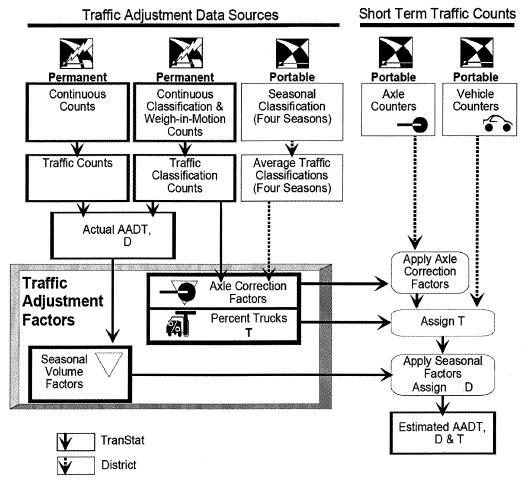
15 MEPDG Input screen
16 0.16 Tandem Axle Load Distribution Lightly Loaded Trucks 0.14 Fraction of Tandem Axles In Weight Group Maximum Weight in a Given Axle Weight Group (x 1,000 lbs)
17 Tandem Axle Load Distribution Heavily Loaded Trucks Fraction of Tandem Axles In Weight Group Maximum Weight in a Given Axle Weight Group (x 1,000 lbs)
18 ESAL Comparison Lightly Loaded = (flexible) Moderately Loaded = Heavily Loaded = Conclusion: Not knowing the loaded/unloaded condition can equal a 3X error in life expectancy
19 Tools to gather Volume, Weight and Classification Data?


20 Tube counters

21 Weigh in Motion Station
22 Data Collection Framework Truck Weight (WIM) Vehicle Classification (CVC) 245 $$$ VOLUME COUNTS Short Term Counts MONITORING SITES Continuous Counts MONITORING SITES $
23 Traffic Quality Control on WIM data Develop WIM input files Cluster analysis in identifying homogeneous traffic patterns. LTTP Plug program Improved default traffic files Improved user derived traffic data
24 Key Fact.. The default data in ME Design is a great start A small amount of good data is better than a large amount of poor quality data.. Typically only 25% of WIM data is has been found to contain quality data.
25 Focus Information on most prevalent vehicles Overweight, permit vehicles Make it practical for design Catalog traffic files

26 Questions???
27 NATMEC 2014 Classification Workshop Steven Bentz
28 The Project Traffic Forecasting Handbook offers guidelines and techniques on the Design Traffic Forecasting Process, and supplements the Project Traffic Forecasting Procedure. The PTF Handbook is a continuation of FDOT s effort to develop an improved traffic forecasting procedure. To standardize methodologies, a statewide survey of engineers and planners who produce or use traffic forecasts was conducted to determine the actual methods in use throughout the Districts. A task team was formed to draft a compilation and explanation of the standardized design traffic forecasting methodologies. The result was the Project Traffic Forecasting Handbook. It represents a consensus approach to traffic forecasting.


29 The new PTF 101 training course is on-line and operational. It is comprised of 17 modules which include a Fundamental Introduction, an Overview, and Basic, Advanced, and Assessment modules for Preservation, Operational Improvement, Capacity Improvement and New Alignment type projects. The course can be simply viewed or users may enroll in order to receive a certificate upon successful completion and receive 16 PDH s. The course numbers are: FDOT Course Number: PE FBPE Course Number:
30 PROJECT TRAFFIC FORECASTING (PTF) The process to estimate traffic conditions used for determining the geometric design of a roadway and/or intersection and the number of 18-KIP ESALs that pavement will be subjected to over the design life.
31 Project Traffic Forecasting estimates are needed for Planning and Project Development and Environmental (PD&E) studies and construction plans which lead to construction, traffic improvements, and pavement design projects. A Project Traffic Report is routinely developed as part of most Project Development and Environmental Studies. FDOT s Roadway Plans Preparation Manual requires Project Traffic and its major parameters to be posted on the Typical Section sheets.
32
33 Corridor projects usually require the development of travel projections which are used to make decisions which have important capacity and capital investment implications. The traffic forecasting is required before establishing a new alignment or widening of an existing facility.
34 The Project Traffic projections are commonly used to develop laneage requirements for intersection designs, and to evaluate the operational efficiency of proposed improvements. Project Traffic Forecasting is also required for reconstruction, resurfacing, adding lanes, bridge replacement, new roadway projects, and major intersection improvements. This process differs from Corridor Traffic Forecasting in that it is site specific and covers a limited geographic area.
35 The Equivalent Single Axle Loading (ESAL) Forecasting Process is necessary for pavement design for new construction, reconstruction, or resurfacing projects. Truck traffic and damage factors are needed to calculate axle loads expressed as ESALs.
36 The four major types of construction projects are : Preservation (resurfacing) Intersection Operational Improvements (add turns lanes) Roadway Capacity Improvements (add through lanes) New Alignment Projects. Traffic operations projects such as signal timing, signal phasing and other non-construction type projects are not covered under this procedure.
37 Construction projects require both the Project Traffic Forecasting Process and the Equivalent Single Axle Load (ESAL) Process to be performed. Preservation Projects, which are usually resurfacing projects, only require the ESAL process to determine the appropriate Load Equivalency Factor for the pavement to be laid. Corridor Traffic Forecasting and Project Traffic Forecasting projects require forecasts of Annual Average Daily Traffic (AADT) and Design Hour Volumes (DHV).
38 TRUTH IN DATA PRINCIPLE The goal of the principle is to provide the user with the information needed to make appropriate choices regarding the applicability of the forecast for particular purposes. For the producer of the traffic forecast, it means clearly stating the input assumptions and their sources, and providing the forecast in a form that the user can understand and use.

39 TRAFFIC MONITORING SITES IN FLORIDA
40 STANDARD K FACTORS FDOT has decided to replace the K30 factors with Standard K factors. This has occurred because it has been widely recognized that roadways in urbanized areas cannot be cost effectively designed based on the 30th highest hour demand volumes. Standard K factors have been established statewide by using the data measured at the continuous count sites. The Standard K factors are based on area type and facility type with consideration to typical peak periods of the day.
41
42

43 Project Traffic Forecasting Process
44 The End (850)
45 IDOT CLASSIFICATION William Morgan Data Management Unit Chief
46 CLASSIFICATION Collection Quality Control Factoring Users of Data How we report

47 COLLECTION ATR Sites Total Classification - 66 Volume - 45 Types TRS - 97 WIM - 3 TIRTL - 11

48 COLLECTION Short Term Counts District Staff Consultant Contracts
49 QUALITY CONTROL - ATR ATR Sites Sites polled twice a week. Review numbers and look for issues and missing data On our TIRTL sites, we also review the specific beam levels and angles, and current live status to see current traffic numbers.
50 QUALITY CONTROL SHORT TERM Review historical counts for SU & MU Look at traffic flow of current counts along route Drastic changes in AADT can warrant new breaks in count segments due to new traffic generators (New shopping centers, subdivisions, etc.)
51 FACTORING Utilize monthly and day of week factors (Seasonal). Broken down into 4 groups based on roadway type (Interstate/Other) and rural/urban classification. Create growth factors based on last two years worth of data. Seasonal factors are based on 4 year rolling average.
52 IDOT USERS OF DATA AADT, SU & MU breakout used by Design & Bridges AADT/VMT used by Traffic Safety and Safety Engineering when reviewing crash data. AADT Planning uses during annual program cycle.
53 OTHER USERS OF DATA AADT County, City, MPOs, Legislature, Governors office, researchers, businesses, etc. Many of these use for planning purposes, analysis patterns.
54 HOW WE REPORT DATA External Websites Internal web site IRoads

55


56
57

58 IDOT MS2 Hosted site/

59 IRoads
60 Michigan our fit in the department Classification data short term Continuous vehicle classifications axle and weights Equipment and sites configuration Sites Use of data Limited length classification Michigan Department of Transportation

61 Michigan Department of Transportation Bureau of Transportation Planning Asset Management Division Asset Management Section Data Collection and Analysis Section Asset Management Council Coordinator Framework System Monitoring Pavement Condition Monitoring Michigan Department of Transportation Electronic Services Unit Statewide Operations Studies Unit Travel Information Unit
62 Operations/Safety Signals Stop signs Intersection improvements Speed limits Weight enforcement Project Level Planning Traffic Analysis $$$ Million Federal Aid Uses of Traffic Information Pavement Design Management Legislative Analysis Revenue Size & weight Models Travel Demand Forecasting Air Quality Michigan Department of Transportation Traffic/Travel Information Public Gov. agencies Universities Private companies Multi-Modal Air Rail Bus
63 Short Term Class (13 bin hose, 3 bin video, 4 bin radar) We don t collect length classification data at our continuous count station (CCS) sites State crew performs maintenance/upgrades Contractors for new pavement installations In-house monitoring suite of tools including polling program/traffic processing software WIM analyst reviewing data/equipment weekly Michigan Department of Transportation

64 State Crew Repair and Upgrades
65

66 Loop Sensor Classification Configuration Michigan Department of Transportation
67 Sites selection Collaboration for the placement of new WIM site installations and upgrades: -Working with State Commercial Vehicle Enforcement, Transportation Planners and Pavement Design Teams -Freight community and Third party vendors (PrePass and DriveWyze). Michigan Department of Transportation
68 Michigan Department of Transportation MEPDG research needs leads to new location WIM site recommendations
69 Use 6 by 6 loops with 45 angles for counting (Phoenix) 15 Piezo BL for class (PAT) 41 Quartz WIM axle (PAT) 2 3M Micro loop Classifications 141 sites overall, of which 58 sites reporting class Michigan Department of Transportation
70 Planning 13 Bin, 3 bin, 4 bin for project, AADTT reporting, HPMS Air Quality Overweight analysis Axle WIM data for enforcement strategies Truck Vehicle Registration/Policy Axle and WIM Pavement Design PREP-ME inputs Bridge Loadings Commercial Vehicle Enforcement (Virtual WIM sites) PrePass and DriveWyze Project and future plans Equivalent Single Axle Load (ESAL) Class data to MPO s Software issues include needed upgrades Michigan Department of Transportation
] Michigan Department of")
71 Loop- and Length-Based Vehicle Classification, Federal Highway Administration Pooled Fund Program [TPF-5(192)] Michigan Department of Transportation
72 Overlapping or gray areas with types vehicles Axle based (WIM) for Enforcement Length (accuracy issues using defaults) for Pavement Design MOVES (Air Quality) Information provided to: MDOT staff and other state agencies FHWA MPO s and RPO s Public/Consultants Researchers (weights, truck parking, pavement design, bridge design) Michigan Axle Loadings Michigan Department of Transportation
73 Michigan has a unique system of truck-weight law based on maximum axle loadings, not gross vehicle weight (GVW). Gross vehicle weight includes the weights of the truck, cargo, fuel, and driver; axle loading is the weight on a single axle. Maximum allowable axle loadings are the same for a standard truck in all states, but Michigan allows use of more axles in combination with lower axle loadings, for a greater gross vehicle weight than other states. Michigan Department of Transportation
74 The maximum gross vehicle weight allowed on a federal-weight-law truck is 80,000 pounds, with four of its five axles carrying 17,000 pounds each and the steering axle carrying 12,000 pounds. The maximum allowable gross vehicle weight on the heaviest Michigan-weight-law truck is 164,000 pounds, which can only be achieved by use of eleven properly-spaced axles. Most of these axles carry only 13,000 pounds each. Michigan Department of Transportation
75 Most of these axles carry only 13,000 pounds each. The alternative to a single Michigan combination carrying 160,000 lbs. on 11 axles is two standard trucks carrying 160,000 lbs. on 10 axles Michigan s axle loading system has a critical dependence with the FHWA Scheme F classification criteria. Michigan Department of Transportation
76 Michigan Department of Transportation
77 For More information: Lawrence Whiteside Travel Information Unit, Asset Management Division Michigan Department of Transportation Phone: Michigan Department of Transportation
78 Using Vehicle Class Data for Pavement Deterioration and Other Purposes Roger D. Mingo, P.E. R.D. Mingo and Associates
79 People Interested in Class Data Data Providers Collectors and Compilers Who Strive Constantly for More and Better Data Data Users Analyze Trends, Plan Highways, or Formulate Policies Based on Trends
80 People Interested in Class Data Data Providers Collectors and Compilers Who Strive Constantly for More and Better Data Data Users Analyze Trends, Plan Highways, or Formulate Policies Based on Trends Data Dabblers Every So Often, Gather and Analyze as Much Data as Possible for Some Specific Purpose
81 Examples of Why We Dabble Highway Cost Allocation (HCAS) How much highway resource does each class of highway user consume? Truck Size and Weight (TSW) Policy If we allow bigger trucks / heavier trucks / heavier axle loads, what happens to our highways and highway users?
82 Simple Questions, Simple Needs Travel by Vehicle Class Typical HCAS or TSW studies need more than 13 vehicle classes Vehicles on Various Highway Types Vehicles have different travel patterns and impacts on different types of highways Vehicle Weights and Axle Weights Pavement, bridge, and interference impacts vary by vehicle weight, axle weights, and axle spacings.
83 Bottom Line: Insatiable Demand VMT Array Needed Travel by 28 vehicle classes, 12 highway classes, and 51 states / colonies More Detail Break down vehicle class travel by 100 operating weight groups, and develop a characteristic array of 120 axle weights / types for each Quality Compromise Better data allows better analysis, and therefore better decisions.

84
85 Path from VM1 and VM2 Tables VM2 Tables Contain FHWA estimates of travel by all vehicles in each state and highway type Classification Data If complete and accurate, would get us half way to the large VMT array we need WIM Data Allows finer breakdown of vehicle types and provides operating weight and axle weight details
86 Role of Class Data More Detail than Counts Traffic counts alone provide limited value to studies of trucks More Spatial Coverage than WIM In the latest (December 2013) sweep of data compiled by FHWA, we got nearly 2400 class stations, only 451 WIM stations (plus 19 LTPP WIM stations). Can Work with WIM Weights of axles, combined with spacings, provide opportunity for improved classification accuracy
87 Limitations of Class Data Difficult to Compile and Extract VTRIS, TMAS, dbf formats, file name variety Incomplete Coverage 2400 compiled class stations cover only 220 of cells in the state / functional-class (612 needed) High Error Rate for Some Classes Catchall class 13 has been a historic problem (better, though, when class 14 is used)
88 Improvements? 13 Classes? Get rid of catchall classes. Don t overreach. Aggregate / Disaggregate? Maybe, but much value comes from the raw data Length Based? What else is there? Critical Needs of Dabbler Community? More data, more accessibility, more housekeeping

89 2014 NATMEC Conference Classification Workshop Scott Petersen, P.E. June 29,
90 Project Team Gene Hicks, Mn/DOT Project Manager Steven Jessberger, FHWA Erik Minge, SRF Consulting Group Scott Petersen, SRF Consulting Group Herb Weinblatt, Cambridge Systematics Benjamin Coifman, Ohio State University Earl Hoekman, EL Enterprises 90
91 Participating Agencies/TAC Maryann Dierckman, Alaska Aaron Moss, Colorado Anne-Marie McDonnell, Connecticut Steven Bentz, Florida Jack Helton, Idaho Rob Robinson, Illinois Jim Kramer, Michigan Gene Hicks, Minnesota Kurt Matias, New York Dave Gardner and Lindsey Pflum, Ohio Andrea Bahoric, Pennsylvania Bill Knowles, Texas Ken Lakey, Washington John Williamson, Wisconsin Mark Wingate, Wyoming 91
92 Literature Review Loop Characteristics Loop Detector Errors Length Classification Issues Inductive Signature-Based Detectors Non-Loop Detectors Uses for Length-Based Classification 92

93 Traditional Classification Method FHWA 13 Class Scheme 93
94 Proposed Length Bins What length thresholds should be used? LBVC Scheme Corresponding Axle Classes MC MC MC MC MC MC 1 A A 2 S S S S LT LT 3 M M M M 3T, 5-7 M M ML ML ML ML 4 L L L 8-12 L L L VL VL VL 13 94

95 Proposed Length Bins What length thresholds should be used? LBVC Scheme Corresponding Axle Classes MC MC MC MC MC MC 1 A A 2 S S S S LT LT 3 M M M M 3T, 5-7 M M ML ML ML ML 4 L L L 8-12 L L L VL VL VL 13 95
96 Vehicle Length Distribution by Class 96
97 Proposed Length Bins What length thresholds should be used? Motorcycles Autos/Light Trucks Autos with Trailers/ Single Unit Trucks T 3T 4 5 5T 6 MC S M 6.75 feet 22 feet feet Multi-Unit Trucks L VL 97

98 Proposed Length Bins What length thresholds should be used? Motorcycles Autos/Light Trucks Autos with Trailers/ Single Unit Trucks T 3T 4 5 5T 6 MC S M 6.75 feet 22 feet feet Multi-Unit Trucks L VL 85 feet? 98

99 Length Classes MC and S Threshold Results LTPP Data 99

100 Length Class M Threshold Results LTPP Data 100

101 Length Class L Threshold Results LTPP Data 101


102 Field Test: How Accurate Are Length-Based Sensors? Detector Model Loop shape 6 x6 6 x8 Quadrupole Blade Loop Loop lead-in length 102
103 I-35 Test Site Loop Layout (Wyoming, MN) 103
104 Field Test - Detectors Loop Detectors Manufacturer Model Diamond Phoenix I Diamond Phoenix II GTT Canoga C944 IRD TCC-540 IRD TRS PEEK ADR 3000 Non-Loop Detectors Manufacturer GTT Vaisala/Nu-Metrics Vaisala/Nu-Metrics Wavetronix Model Canoga Microloops (C944 Card) Hi-Star NC200 ION Hi-Star NC300 SmartSensor HD 104
105 Field Test - Detectors Inductive Signature Detectors Manufacturer Model Diamond iloop IST IST-222 PEEK ADR
106 Video Ground Truth High-resolution video screenshots Pixel-measurement Average absolute error 0.43 ft Errors generally within one foot 106
107 Loop Detector Field Test Results Length and Speed 80 Detector Speed (mph) Diamond Phoenix II - 6x6 Loop PEEK ADR Detector Length (feet) Baseline Length (feet) Baseline Speed (mph) 107
108 Loop Detector Field Results Normal Lead-In ( ) Manufacturer Model 6 x6 loops 6 x8 loops Quadrupoles (feet) (feet) (feet) Diamond Phoenix I Diamond Phoenix II Not Tested GTT Canoga C IRD TCC IRD TRS Did Not Function PEEK ADR
109 Loop Detector Field Results Long Lead-In (1,500 ) Manufacturer Model Average Absolute Length Error (feet) Diamond Phoenix I 0.97 Diamond Phoenix II 1.18 GTT Canoga C IRD TCC IRD TRS Not Tested PEEK ADR

110 Inductive Signature Detector Results 110

111 Laboratory Test Objectives Determine repeatability of detector data Directly compare detector results with same vehicle signatures 111
112 Average Absolute Error (ft) Laboratory Results - Length ADR GTT C924 Phoenix I 2 Phoenix II 1 TCC-540 TRS 0 All Vehicles Axle Class 1 Axle Classes 2-3 Axle Classes 2-3 (excl. trailers) Axles Classes
113 Average Absolute Error (mph) Laboratory Results - Speed ADR3000 GTT C924 Phoenix I Phoenix II TCC-540 TRS 0.0 All Vehicles Axle Class 1 Axle Classes 2-3 Axle Classes 2-3 (excl. trailers) Axle Classes

114 Calibration Procedure Probe Vehicle Selection and Procedure 114
115 Conclusions Length classification is less precise than classification by axle spacing and/or weight Significant overlap between lengths among various axle classes Passenger vehicles with trailers classified as Medium Selected length scheme thresholds designed to balance misclassification 115
116 Conclusions When calibrated, loop detectors report accurate vehicle lengths Average absolute error less than two feet across all vehicles Calibration is an important step Select a calibration vehicle that has a magnetic length that is close to the physical length (auto, semi w/lowboy) 6 x6 and 6 x8 loops offer excellent length detection performance and should continue to be installed Benefit to motorcycle detection with 6 x8 loops 116
117 Contact Scott Petersen, SRF Consulting Group Gene Hicks, Mn/DOT Project Manager, Erik Minge, SRF Consulting Group Herb Weinblatt, Cambridge Systematics 117
118 2014 NATMEC Classification Workshop June 29, 2014 Chicago, IL
119 Overview Class Data Collection, Usage and Issues NATMEC 2014 Improving Traffic Data Collection, Analysis, and Use Tianjia Tang, PE, Ph.D. Chief, Travel Monitoring and Surveys Division Office of Highway Policy Information, Federal Highway Administration
120 Objective 1) To review whether the current system still meets the needs, 2) How to take advantage of current data capturing technology, 3) What new technology and policy program and initiatives both the private and public sectors should focus on.

121
122 Data Reported to FHWA I. HPMS - 6 Vehicle Groups: MC, Bus, LD-SWB, LD-LWB, SUV, and CT 2. WIM all 13 Vehicle Types 3. Volume 1 4. Class 13 vehicle types
123 FHWA Usage Fund Apportionment actual apportionment and legislative scenario analysis Safety analysis Cost allocation analysis Trending analysis Fuel consumption Greenhouse gas emission Fuel efficiency Others
124 Highway Noise Modeling Five vehicle types 1. automobiles, 2. medium trucks, 3. heavy trucks, 4. buses, 5. motorcycles
125 Air Quality Modeling EPA s MOVES Model

126 Air Quality Modeling
127 Transportation Demand Modeling System wide POV, bus and truck most likely Project level may be as automobiles, medium trucks, heavy trucks, buses, and motorcycles.
128 Roadway Geometric Design # of lane - volume only Lane width POV and truck % Horizontal curvature volume only and design vehicle Vertical curve % of truck only.
129 Roadway Pavement Design AASHTO ESAL method (1993 AASHTO Design Guide): single axles, Tandem axles, and Triple Axles Asphalt Institute Handbook same as AASHTO AASHTO Mechanistic and Empirical Design FHWA 13 vehicle types

130 Bridge Design ( 2 types) Standard Specifications for Highway Bridges AASHTO - three types of design vehicles loads. 1: H Truck - two axle 20-ton configuration and 15 ton Configuration 2: HS Truck - conventional semi- or tractor-trailer vehicle 3: String arrangement vehicle groups 15 T 20 T 15 T
131 Pavement/Bridge Deterioration Analysis No fixed number of vehicle categories. In theory, the more class, and the more class with both axle weight and gross vehicle weight, the more precise correlations can be drawn.

132 New Phenomena TPF5192 MN DOT Pool Fund Study
133 What We Should Do

134 CLASSIFICATION EXPERT PANEL NATMEC WORKSHOP Overview of Wisconsin s Continous Count Program S U S I E F O R D E, S E C T I O N C H I E F O F D A T A M A N A G E M E N T W I S C O N S I N D E P A R T M E N T O F T R A N S P O R T A T I O N R H O N D A M C D O N A L D, T R A F F I C D A T A A N A LY S T W I S C O N S I N D E P A R T M E N T O F T R A N S P O R T A T I O N

135 STATE OF WISCONSIN PROFILE System Miles Interstate 743 PA Freeway Expressway 573 PA Other 4903 Minor Arterial 7436 Major Collector Minor Collector 8621 Local Total 115,145 Local / County Roads = 100,000+ miles Local Government Jurisdictions State of Wisconsin ,260 County City Village Town Wisconsin Department of Transportation
 Continuous Short-Term WIM Policy & Processing HPMS Field")
 Local Roads (WISLR) Wisconsin Department of")
136 136 DATA MANAGEMENT SECTION BUREAU OF STATE HIGHWAY PROGRAMS ROADWAY AND TRAFFIC DATA PROGRAMS Administer Statewide Policy and Guidelines for Roadway Data Traffic (Central Ofc) Continuous Short-Term WIM Policy & Processing HPMS Field Ops Continuous Traffic Data Collection Maintenance and Installation Meet Federal & State Mandates Process Share Linework and Data Submit Roadway Data to Federal Highways State Highway (STN) Local Roads (WISLR) Wisconsin Department of Transportation
137 WISDOT Traffic Data Staffing Levels 137 Central Office Responsibilities Administer Policy and Federal Guidelines Oversee Contracts, Budgets Process Continuous, Video, Short-Duration, WIM, and Special Counts Staffing Level 4 Full Time Employees 1 Seasonal Employee Field Operations Responsibilities Maintenance ATR Sites Oversee Installation ATR and WIM Sites Maintain Short-Term Equipment Manage Materials and Supplies Staffing Level 2 Full Time Employees 1 Seasonal Employee Wisconsin Department of Transportation
138 WISDOT Traffic Program Overview 138 Installation / Maintenance Data Collection Production Processing Outputs Equipment Wavetronix Diamond Peek Timemark (S-T) Communications Data Remote Sierra Contract Oversight Short-Term Cycle (Even/Odd) Download VIAS Continuous 24/7 365 Days/yr WIM Specials Upon Request Autopolling Datacollector Centurion Viper TRADAS Process Daily Troubleshoot Reprocessing Monthly Annual Quality Control Preliminary AADT to Prior Final AADT Corridor TRADAS Edits Federal TMAS HPMS Internal Local Road System Forecasting VMT Pavement Design Hwy Programming Regional Planners Safety Engineers External Tribal MPOs RPCs Public Consultants Wisconsin Department of Transportation
139 Data Equipment Schematic 139 Wisconsin Department of Transportation
 PROCESS DOCUMENTATION GIS-PLOTTING Wisconsin Department of")
140 WISDOT QUALITY CONTROL PROCESS 140 % Change report GIS PLOTTING (corridor) PROCESS DOCUMENTATION GIS-PLOTTING Wisconsin Department of Transportation
141 WisDOT Continuous Axle & Length Schemes 141 FHWA (axle) WisDOT Length HPMS (axle) 1 (MC) 2 (PC) 3 (SU2-4) 4 (BUSES) 5 (SU2-6) 6 (SU3) 7 (SU4+) BIN 1 BIN 2 BIN 3 1 (MC) 2 (PV) 3 (LT) 4 (BUS) 5 (SU) 8 (ST4-) 9 (ST5) 10 (ST6+) BIN 4 6 (CU) 11 (MU5-) 12 (MU6) 13 (MU7+) BIN 5 Wisconsin Department of Transportation
142 FACTORS APPLIED TRADAS Annual Processing Phase II Generate and Apply All Factors To AADT values generated from Phase I 1.0 Phase I Compute AADT for Continuous Sites TRADAS DATA BASE Recompute and Apply Factors To Short-Duration Counts Collected for that Year 3.0 Phase III Copy AADT Values from RR to RR.Net Using Phase I & III Outputs 4.0 Phase IV This Step is executed by Vendor Output from Phase IV as input for HPMS This step applies growth factors to non-collected S-T counts sites Traffic file for HPMS Wisconsin Department of Transportation
143 Reporting Of WisDOT Traffic Data 143 MONTHLY TMAS REGION REPORTS Quarterly TAFIS Meta ANNUAL RR WEB (shortterm) Continuous Count Data HPMS WISLR (LR) CLASSIFICATION BOOK Wisconsin Department of Transportation

144 Traffic Data Users 144 Uses Department External Design Pavement Designers Federal Highways Safety Safety Engineers Local Agencies Operations Forecasting Developers Expansion Planning Wisconsin Department of Transportation


145 WISDOT Continuous Count Program Current View of Axle to Length Percent Comparison Axle to Length Percent Comparison 206 ATR Sites 174 length 84% 32 axle 16% 252 ATR 174 length 69% 78 axle 31% Wisconsin Department of Transportation
146 Axle to Length Cost Comparison 146 Type of Station Type of Station A ve r a g e C O S T Install New 4-l a n e S i t e Contract Install Materials Recorder Total Net Difference Axle $24,000 $ 9,000 $ 2,200 $ 35,200 Length $7,000 $ 5,900 $ 5,400 $ 18,300 A v e r a g e REPAIR C O S T 4-l a n e S i t e Contract / DOT Maint Materials Total Net Difference Axle $21,500 $ 3,600 $ 25,100 Length $500 $ 250 $ 750 Axle Higher resolution (MC, Cars, Pickups, etc) Higher installation and maintenance costs Lane closures Timeliness of maintenance Wisconsin Department of Transportation $ 24,350 $ 16,900 Total Net Diff Install + Maint Per Site $41,250 Length Lower resolution (Passenger, Single-Unit, Combos) Lower installation and maintenance costs Non-intrusive technologies reduce costs Very few maintenance needs

147 Steps To Tune Continuous Count Program Commitment to Quality Traffic Data Review Traffic Program Increase Axle / Length Ratio: 31% / 69% By Axle / 174 Length 2. Contract with industry traffic data expert Analyze Wisconsin s Length to Axle data Recommendations to fine tune FHWA TMG Training Wisconsin Hosted: Iowa, Minnesota, Kansas July 2013, La Crosse, Wisconsin Wisconsin Department of Transportation
148 Monday, 10:30 Noon Room: Montreaux HOW GOOD ARE MY DATA? WISCONSIN DOT CASE STUDY A ND FINDINGS: UNDERSTANDING THE SIGNIFICANCE OF CLASS VERSUS LENGTH ON AXLE FACTORS AND ITS EFFECT ON AADT TO ENSURE RELIABLE TRAFFIC DATA Wisconsin Department of Transportation
UNDERSTANDING THE SIGNIFICANCE OF AXLE VERSUS LENGTH CLASSIFICATION ON AXLE FACTORS AND THE EFFECT ON AADT TO ENSURE RELIABLE TRAFFIC DATA
 WISCONSIN DOT CASE STUDY FINDINGS UNDERSTANDING THE SIGNIFICANCE OF AXLE VERSUS LENGTH CLASSIFICATION ON AXLE FACTORS AND THE EFFECT ON AADT TO ENSURE RELIABLE TRAFFIC DATA NATMEC 2014, Chicago, Illinois
Traffic Data For Mechanistic Pavement Design
 NCHRP 1-391 Traffic Data For Mechanistic Pavement Design NCHRP 1-391 Required traffic loads are defined by the NCHRP 1-37A project software NCHRP 1-39 supplies a more robust mechanism to enter that data
CHARACTERIZATION AND DEVELOPMENT OF TRUCK LOAD SPECTRA FOR CURRENT AND FUTURE PAVEMENT DESIGN PRACTICES IN LOUISIANA
 CHARACTERIZATION AND DEVELOPMENT OF TRUCK LOAD SPECTRA FOR CURRENT AND FUTURE PAVEMENT DESIGN PRACTICES IN LOUISIANA LSU Research Team Sherif Ishak Hak-Chul Shin Bharath K Sridhar OUTLINE BACKGROUND AND
Length-Based Vehicle Classification Schemes and Length-Bin Boundaries
 Herbert Weinblatt, Erik Minge, Scott Petersen 1 1 2 3 4 5 6 7 8 9 10 11 12 13 14 15 16 17 18 19 20 21 22 23 Length-Based Vehicle Classification Schemes and Length-Bin Boundaries 11/14/2012 Word Count =
Truck Axle Weight Distributions
 Truck Axle Weight Distributions Implementation Report IR-16-02 Prepared for Texas Department of Transportation Maintenance Division Prepared by Texas A&M Transportation Institute Cesar Quiroga Jing Li
Understanding Freight Vehicle Pavement Impacts: How do Passenger Vehicles and Trucks Compare?
 Understanding Freight Vehicle Pavement Impacts: How do Passenger Vehicles and Trucks Compare? Introduction With annual logistics costs equal to more than 8 percent of the US GDP,1 and an average of 64
TRAFFIC VOLUME TRENDS
 Page 1 U. S. Department Transportation Federal Highway Administration Office Highway Policy Information TRAFFIC VOLUME TRENDS September Travel on all roads and streets changed by +2.5 (5.8 billion vehicle
Freight Performance Measures Using Truck GPS Data and the Application of National Performance Measure Research Data Set (NPMRDS)
") Freight Performance Measures Using Truck GPS Data and the Application of National Performance Measure Research Data Set (NPMRDS) Chen-Fu Liao Department of Civil, Environmental, and Geo- Engineering University
Freight Performance Measures Using Truck GPS Data and the Application of National Performance Measure Research Data Set (NPMRDS) Chen-Fu Liao Department of Civil, Environmental, and Geo- Engineering University
FHWA/IN/JTRP-2000/23. Final Report. Sedat Gulen John Nagle John Weaver Victor Gallivan
 FHWA/IN/JTRP-2000/23 Final Report DETERMINATION OF PRACTICAL ESALS PER TRUCK VALUES ON INDIANA ROADS Sedat Gulen John Nagle John Weaver Victor Gallivan December 2000 Final Report FHWA/IN/JTRP-2000/23 DETERMINATION
MPO Staff Report Technical Advisory Committee: July 12, 2017
 MPO Staff Report Technical Advisory Committee: July 12, 2017 RECOMMENDED ACTION: 2 nd TAC Meeting with Kimley-Horn/WSB in Updating the Street/Highway Element of 2045 Metropolitan Transportation Plan. Matter
WIM #40 is located on US 52 near South St. Paul in Dakota county.
 WIM Site Location WIM #40 is located on US 52 near South St. Paul in Dakota county. System Operation WIM #40 was operational for the entire month of November 2017. Volume was computed using all monthly
Structural Considerations in Moving Mega Loads on Idaho Highways
 51 st Annual Idaho Asphalt Conference October 27, 2011 Structural Considerations in Moving Mega Loads on Idaho Highways By: Harold L. Von Quintus, P.E. Focus: Overview mechanistic-empirical procedures
WIM #39 MN 43, MP 45.2 WINONA, MN APRIL 2010 MONTHLY REPORT
 WIM #39 MN 43, MP 45.2 WINONA, MN APRIL 2010 MONTHLY REPORT In order to understand the vehicle classes and groupings the Mn/DOT Vehicle Classification Scheme and the Vehicle Class Groupings for Forecasting
Benefit Cost Analysis
 Benefit Cost Analysis The Benefit Cost Analysis (BCA) was performed in accordance with the ARRA guidance provided in the Federal Register. These benefits and costs were quantified in accordance with the
WIM #41 CSAH 14, MP 14.9 CROOKSTON, MINNESOTA APRIL 2014 MONTHLY REPORT
 WIM #41 CSAH 14, MP 14.9 CROOKSTON, MINNESOTA APRIL 2014 MONTHLY REPORT In order to understand the vehicle classes and groupings, the MnDOT Vehicle Classification Scheme and the Vehicle Classification
Open House. Highway212. Meetings. Corridor Access Management, Safety & Phasing Plan. 5:30 to 6:30 p.m. - Southwest Corridor Transportation Coalition
 Welcome Meetings 5:30 to 6:30 p.m. - Southwest Corridor Transportation Coalition 6:30 to 8:00 p.m. - Open House Why is Highway 212 Project Important? Important Arterial Route Local Support Highway 212
WIM #48 is located on CSAH 5 near Storden in Cottonwood county.
 WIM Site Location WIM #48 is located on CSAH 5 near Storden in Cottonwood county. System Operation WIM #48 was operational for the entire month of August 2017. Volume was computed using all monthly data.
TRAFFIC VOLUME TRENDS July 2002
 TRAFFIC VOLUME TRENDS July 2002 Travel on all roads and streets changed by +2.3 percent for July 2002 as compared to July 2001. Estimated Vehicle-Miles of Travel by Region - July 2002 - (in Billions) West
WIM #37 was operational for the entire month of September Volume was computed using all monthly data.
 SEPTEMBER 2016 WIM Site Location WIM #37 is located on I-94 near Otsego in Wright county. The WIM is located only on the westbound (WB) side of I-94, meaning that all data mentioned in this report pertains
WIM #40 US 52, MP S. ST. PAUL, MN APRIL 2010 MONTHLY REPORT
 WIM #40 US 52, MP 126.8 S. ST. PAUL, MN APRIL 2010 MONTHLY REPORT In order to understand the vehicle classes and groupings the Mn/DOT Vehicle Classification Scheme and the Vehicle Class Groupings for Forecasting
Presentation Outline. TRB MEPDG Workshop. Traffic Data & WIM Program. WIM Program in WIM program (prior to MEPDG) Utilizing WIM data
 Utilizing WIM data") Presentation Outline TRB MEPDG Workshop Traffic & Axle Weight Data Brian Diefenderfer, PhD, PE Research Scientist Virginia Transportation Research Council Charlottesville, VA January 13, 2008 WIM program
Presentation Outline TRB MEPDG Workshop Traffic & Axle Weight Data Brian Diefenderfer, PhD, PE Research Scientist Virginia Transportation Research Council Charlottesville, VA January 13, 2008 WIM program
Development of Weight-in-Motion Data Analysis Software
 Development of Weight-in-Motion Data Analysis Software Rafiqul A. Tarefder and Md Amanul Hasan Abstract While volumetric data were sufficient for roadway design in the past, weight data are needed for
Project Title: Using Truck GPS Data for Freight Performance Analysis in the Twin Cities Metro Area Prepared by: Chen-Fu Liao (PI) Task Due: 9/30/2013
 Task Due: 9/30/2013") MnDOT Contract No. 998 Work Order No.47 213 Project Title: Using Truck GPS Data for Freight Performance Analysis in the Twin Cities Metro Area Prepared by: Chen-Fu Liao (PI) Task Due: 9/3/213 TASK #4:
MnDOT Contract No. 998 Work Order No.47 213 Project Title: Using Truck GPS Data for Freight Performance Analysis in the Twin Cities Metro Area Prepared by: Chen-Fu Liao (PI) Task Due: 9/3/213 TASK #4:
WIM #41 CSAH 14, MP 14.9 CROOKSTON, MINNESOTA MAY 2013 MONTHLY REPORT
 WIM #41 CSAH 14, MP 14.9 CROOKSTON, MINNESOTA MAY 2013 MONTHLY REPORT In order to understand the vehicle classes and groupings the Mn/DOT Vehicle Classification Scheme and the Vehicle Classification Groupings
Technical Memorandum Analysis Procedures and Mobility Performance Measures 100 Most Congested Texas Road Sections What s New for 2015
 Technical Memorandum Analysis Procedures and Mobility Performance Measures 100 Most Congested Texas Road Sections Prepared by Texas A&M Transportation Institute August 2015 This memo documents the analysis
Bella Vista Bypass Benefit Cost Analysis
 Bella Vista Benefit Cost Analysis The Benefit Cost Analysis (BCA) was performed in accordance with the ARRA guidance provided in the Federal Register. These benefits and costs were quantified in accordance
WIM #29 was operational for the entire month of October Volume was computed using all monthly data.
 OCTOBER 2015 WIM Site Location WIM #29 is located on US 53 near Cotton in St Louis county. System Operation WIM #29 was operational for the entire month of October 2015. Volume was computed using all monthly
Darwin-ME Status and Implementation Efforts_IAC09
 Darwin-ME Status and Implementation Efforts_IAC9 What s Being Used (7 survey) Asphalt Design: MEPDG Darwin-ME Status and Implementation Efforts Idaho Asphalt Conference October, 9 Does SHA Use or Plan
The Value of Travel-Time: Estimates of the Hourly Value of Time for Vehicles in Oregon 2007
 The Value of Travel-Time: Estimates of the Hourly Value of Time for Vehicles in Oregon 2007 Oregon Department of Transportation Long Range Planning Unit June 2008 For questions contact: Denise Whitney
APPENDIX C CATEGORIZATION OF TRAFFIC LOADS
 APPENDIX C CATEGORIZATION OF TRAFFIC LOADS TABLE OF CONTENTS Page INTRODUCTION...C-1 CATEGORIZATION OF TRAFFIC LOADS...C-1 Classification of Vehicles...C-2 Axle Load Distribution Factor...C-2 Estimation
Metropolitan Freeway System 2013 Congestion Report
 Metropolitan Freeway System 2013 Congestion Report Metro District Office of Operations and Maintenance Regional Transportation Management Center May 2014 Table of Contents PURPOSE AND NEED... 1 INTRODUCTION...
2016 Congestion Report
 2016 Congestion Report Metropolitan Freeway System May 2017 2016 Congestion Report 1 Table of Contents Purpose and Need...3 Introduction...3 Methodology...4 2016 Results...5 Explanation of Percentage Miles
A Proposed Modification of the Bridge Gross Weight Formula
 14 MID-CONTINENT TRANSPORTATION SYMPOSIUM PROCEEDINGS A Proposed Modification of the Bridge Gross Weight Formula CARL E. KURT A study was conducted using 1 different truck configurations and the entire
Act 229 Evaluation Report
 R22-1 W21-19 W21-20 Act 229 Evaluation Report Prepared for Prepared by Table of Contents 1. Documentation Page 3 2. Executive Summary 4 2.1. Purpose 4 2.2. Evaluation Results 4 3. Background 4 4. Approach
Emission Rate Approach for Evaluating the Differences in Emissions Between CNG and Diesel Busses
 Emission Rate Approach for Evaluating the Differences in Emissions Between CNG and Diesel Busses By Joon H. Byun, Ph.D. Air Quality Modeling Specialist Federal Highway Administration Background Information
Analysis of Waste & Recyclable Materials Collection Arrangements. Minnesota Pollution Control Agency Presented by Jeff Schneider
 Analysis of Waste & Recyclable Materials Collection Arrangements Minnesota Pollution Control Agency Presented by Jeff Schneider 4-16-2009 Presentation Topics 1. Purpose of Study & Scope of Work 2. Types
Broward County Intermodal Center And People Mover. AASHTO Value Engineering Conference Presentation. September 1, 2009 San Diego, CA
 Project Development & Environment Study Broward County Intermodal Center And People Mover AASHTO Value Engineering Conference Presentation September 1, 2009 San Diego, CA Background P D & E Study Regional
Section 5. Traffic Monitoring Guide May 1, Truck Weight Monitoring
 Section 5 Traffic Monitoring Guide May 1, 2001 Section 5 Truck Weight Monitoring Section 5 Traffic Monitoring Guide May 1, 2001 SECTION 5 CONTENTS Section Page CHAPTER 1 INTRODUCTION TO TRUCK WEIGHT DATA
IMPACTS OF ENERGY DEVELOPMENT ON TEXAS ROADS
 IMPACTS OF ENERGY DEVELOPMENT ON TEXAS ROADS Zheng(Jenny) Li & Magdy Mikhail 9 th International Conference on Managing Pavement Assets, May 18-21, 2015 Table of Contents 1 2 3 4 5 6 Introduction Statewide
D-25 Speed Advisory System
 Report Title Report Date: 2002 D-25 Speed Advisory System Principle Investigator Name Pesti, Geza Affiliation Texas Transportation Institute Address CE/TTI, Room 405-H 3135 TAMU College Station, TX 77843-3135
March 2, 2017 Integrating Transportation Planning, Project Development, and Project Programming
 COORDINATION WITH VDOT DISTRICTS TO DELIVER IMPLEMENTABLE IMPROVEMENT PROJECTS March 2, 2017 Integrating Transportation Planning, Project Development, and Project Programming PRESENTATION OUTLINE What
Alpine Highway to North County Boulevard Connector Study
 Alpine Highway to North County Boulevard Connector Study prepared by Avenue Consultants March 16, 2017 North County Boulevard Connector Study March 16, 2017 Table of Contents 1 Summary of Findings... 1
IRP Webinar International Non-Apportioned
 Outline Webinar International Non-Apportioned Commercial Vehicle Agreement () April 12, 2011. Presenters: Rob Termuende and David Puterman Why is an agreement for Non-Apportioned Commercial Vehicles needed?
A Vision for Highway Automation
 A Vision for Highway Automation R y a n D. R i c e D i r e c t o r o f M o b i l i t y O p e r a t i o n s C o l o r a d o D e p a r t m e n t o f T r a n s p o r t a t i o n Problem Statement Higher
Development of the Idaho Statewide Travel Demand Model Trip Matrices Using Cell Phone OD Data and Origin Destination Matrix Estimation
 Portland State University PDXScholar TREC Friday Seminar Series Transportation Research and Education Center (TREC) 10-24-2016 Development of the Idaho Statewide Travel Demand Model Trip Matrices Using
Minnesota Highway Cost Allocation Study
 Minnesota Highway Cost Allocation Study Hao-Wei Chen Diwakar Gupta Industrial & Systems Engineering Program Outline Highway Cost Allocation (HCA) Study Minnesota Highway Cost Allocation Tool (MHCAT) HCA
Florida Strategic Highway Safety Planning Florida Strategic Highway Safety Plan (SHSP) Update and Performance Overview
 Update and Performance Overview") Session 1 Florida Strategic Highway Safety Planning Florida Strategic Highway Safety Plan (SHSP) Update and Performance Overview Joe Santos, PE, FDOT, State Safety Office October, 23, 2013 Florida Statistics
Session 1 Florida Strategic Highway Safety Planning Florida Strategic Highway Safety Plan (SHSP) Update and Performance Overview Joe Santos, PE, FDOT, State Safety Office October, 23, 2013 Florida Statistics
WIM #31 US 2, MP 8.0 EAST GRAND FORKS, MN JANUARY 2015 MONTHLY REPORT
 WIM #31 US 2, MP 8.0 EAST GRAND FORKS, MN JANUARY 2015 MONTHLY REPORT WIM #31 EAST GRAND FORKS MONTHLY REPORT - JANUARY 2015 WIM Site Location WIM #31 is located on US 2 at mile post 8.0, southeast of
3.15 SAFETY AND SECURITY
 3.15 SAFETY AND SECURITY Introduction This section describes the environmental setting and potential effects of the alternatives analyzed in this EIR with regard to safety and security in the SantaClara-Alum
Harlem Avenue between 63 rd and 65 th
 Harlem Avenue between 63 rd and 65 th Public Meeting #2 March 13, 2018 Summit Park District Welcome to the second Public Meeting for the preliminary engineering and environmental studies of Illinois 43
Load Rating for SHVs and EVs
 Load Rating for SHVs and EVs and Other Challenges Lubin Gao, Ph.D., P.E. Senior Bridge Engineer Load Rating Office of Bridges and Structures Federal Highway Administration Outline Introduction Specialized
NDDOT Truck Harmonization Study
 NDDOT Truck Harmonization Study Upper Great Plains Transportation Institute North Dakota State University North Dakota Association of County Engineers January 21, 2016 Bismarck ND Ramkota Hotel Tim Horner,
Introduction and Background Study Purpose
 Introduction and Background The Brent Spence Bridge on I-71/75 across the Ohio River is arguably the single most important piece of transportation infrastructure the Ohio-Kentucky-Indiana (OKI) region.
Call for Projects Congestion Mitigation and Air Quality (CMAQ) Emissions Formulas Technical Advisory Committee
 Emissions Formulas Technical Advisory Committee") Call for Projects Congestion Mitigation and Air Quality (CMAQ) Emissions Formulas Technical Advisory Committee July 18, 2018 Formula Coordination DRCOG under review, considering FHWA toolkit RAQC Argonne
Call for Projects Congestion Mitigation and Air Quality (CMAQ) Emissions Formulas Technical Advisory Committee July 18, 2018 Formula Coordination DRCOG under review, considering FHWA toolkit RAQC Argonne
2010 Idaho Highway Cost Allocation Study
 2010 Idaho Highway Cost Allocation Study Final Report P Balducci R Mingo H Wolff J Stowers H Cohen Battelle Pacific Northwest Division Richland, Washington 99352 Prepared for Idaho Transportation Department
Transportation accomplishments
 1 1 Welcome Transportation accomplishments Federal Funding State Funding Challenges Future Projects 2 Transportation Project: The NDDOT had a record construction season in 2011. Completed $595.6 million
Subarea Study. Manning Avenue (CSAH 15) Corridor Management and Safety Improvement Project. Final Version 1. Washington County.
 Corridor Management and Safety Improvement Project. Final Version 1. Washington County.") Subarea Study Manning Avenue (CSAH 15) Corridor Management and Safety Improvement Project Final Version 1 Washington County June 12, 214 SRF No. 138141 Table of Contents Introduction... 1 Forecast Methodology
Subarea Study Manning Avenue (CSAH 15) Corridor Management and Safety Improvement Project Final Version 1 Washington County June 12, 214 SRF No. 138141 Table of Contents Introduction... 1 Forecast Methodology
AN The SmartSensor HD as an Automatic Traffic Recorder. Automatic Traffic Recorders
 AN-0006 The SmartSensor HD as an Automatic Traffic Recorder The Wavetronix SmartSensor HD can be used as an automatic traffic recorder (ATR) in the process of gathering, storing and analyzing traffic data.
Electric Vehicle Cost-Benefit Analyses
 Electric Vehicle Cost-Benefit Analyses Results of plug-in electric vehicle modeling in eight US states Quick Take M.J. Bradley & Associates (MJB&A) evaluated the costs and States Evaluated benefits of
Missouri Seat Belt Usage Survey for 2017
 Missouri Seat Belt Usage Survey for 2017 Conducted for the Highway Safety & Traffic Division of the Missouri Department of Transportation by The Missouri Safety Center University of Central Missouri Final
The Status of Transportation Funding, Road Charge and Vehicle Miles Traveled in California
 The Status of Transportation Funding, Road Charge and Vehicle Miles Traveled in California Long-Term Policy Options for Sustainable Transportation Options NCSL State Transportation Leaders Symposium October
RTID Travel Demand Modeling: Assumptions and Method of Analysis
 RTID Travel Demand Modeling: Assumptions and Method of Analysis Overall Model and Scenario Assumptions The Puget Sound Regional Council s (PSRC) regional travel demand model was used to forecast travel
Task Force Meeting January 15, 2009
 Task Force Meeting January 15, 2009 Study Update August 14 th Task Force Meeting Update on Traffic Projections and Financial Feasibility Study presented by Kane County and WSA staff The presentation summarized
1 TO 2 2 TO 3 12 TO 1 10 TO TO 12
 STATION: New York State Department of Transportation Traffic Count Hourly Report Page of ROUTE #: NY ROAD NAME: FROM: RT CENTRAL SQUARE : ACC RT I COUNTY: Oswego : Northbound FACR GROUP: REC. SERIAL #:
Use of National Household Travel Survey (NHTS) Data in Assessment of Impacts of PHEVs on Greenhouse Gas (GHG) Emissions and Electricity Demand
 Data in Assessment of Impacts of PHEVs on Greenhouse Gas (GHG) Emissions and Electricity Demand") Use of National Household Travel Survey (NHTS) Data in Assessment of Impacts of PHEVs on Greenhouse Gas (GHG) Emissions and Electricity Demand By Yan Zhou and Anant Vyas Center for Transportation Research
Use of National Household Travel Survey (NHTS) Data in Assessment of Impacts of PHEVs on Greenhouse Gas (GHG) Emissions and Electricity Demand By Yan Zhou and Anant Vyas Center for Transportation Research
Draft Results and Recommendations
 Waco Rapid Transit Corridor (RTC) Feasibility Study Draft Results and Recommendations Chris Evilia, Director of Waco Metropolitan Planning Organization Allen Hunter, General Manager Waco Transit System
Statement before the New Hampshire House Transportation Committee. Research on primary-enforcement safety belt use laws
 Statement before the New Hampshire House Transportation Committee Research on primary-enforcement safety belt use laws Jessica B. Cicchino, Ph.D. Insurance Institute for Highway Safety The Insurance Institute
PROCEDURES FOR ESTIMATING THE TOTAL LOAD EXPERIENCE OF A HIGHWAY AS CONTRIBUTED BY CARGO VEHICLES
 PROCEDURES FOR ESTIMATING THE TOTAL LOAD EXPERIENCE OF A HIGHWAY AS CONTRIBUTED BY CARGO VEHICLES SUMMARY REPORT of Research Report 131-2F Research Study Number 2-10-68-131 A Cooperative Research Program
2030 Multimodal Transportation Study
 2030 Multimodal Transportation Study City of Jacksonville Planning and Development Department Prepared by Ghyabi & Associates April 29,2010 Introduction Presentation Components 1. Study Basis 2. Study
1 TO 2 2 TO 3 3 TO 4 11 TO TO 1
 STATION: New York State Department of Transportation Traffic Count Hourly Report Page of ROUTE #: NY ROAD NAME: FROM: RT : END / OLAP COUNTY: Onondaga : Eastbound FACR GROUP: REC. SERIAL #: AP FUNC. CLASS:
Michigan/Grand River Avenue Transportation Study TECHNICAL MEMORANDUM #18 PROJECTED CARBON DIOXIDE (CO 2 ) EMISSIONS
 EMISSIONS") TECHNICAL MEMORANDUM #18 PROJECTED CARBON DIOXIDE (CO 2 ) EMISSIONS Michigan / Grand River Avenue TECHNICAL MEMORANDUM #18 From: URS Consultant Team To: CATA Project Staff and Technical Committee Topic:
TECHNICAL MEMORANDUM #18 PROJECTED CARBON DIOXIDE (CO 2 ) EMISSIONS Michigan / Grand River Avenue TECHNICAL MEMORANDUM #18 From: URS Consultant Team To: CATA Project Staff and Technical Committee Topic:
FIELD APPLICATIONS OF CORSIM: I-40 FREEWAY DESIGN EVALUATION, OKLAHOMA CITY, OK. Michelle Thomas
 Proceedings of the 1998 Winter Simulation Conference D.J. Medeiros, E.F. Watson, J.S. Carson and M.S. Manivannan, eds. FIELD APPLICATIONS OF CORSIM: I-40 FREEWAY DESIGN EVALUATION, OKLAHOMA CITY, OK Gene
Southern Windsor County 2016 Traffic Count Program Summary April 2017
 Southern Windsor County 2016 Traffic Count Program Summary April 2017 The Southern Windsor County Regional Planning Commission (the RPC ) has been monitoring traffic at 19 locations throughout the southern
Oregon DOT Slow-Speed Weigh-in-Motion (SWIM) Project: Analysis of Initial Weight Data
 Project: Analysis of Initial Weight Data") Portland State University PDXScholar Center for Urban Studies Publications and Reports Center for Urban Studies 7-1997 Oregon DOT Slow-Speed Weigh-in-Motion (SWIM) Project: Analysis of Initial Weight Data
Portland State University PDXScholar Center for Urban Studies Publications and Reports Center for Urban Studies 7-1997 Oregon DOT Slow-Speed Weigh-in-Motion (SWIM) Project: Analysis of Initial Weight Data
The Boston South Station HSIPR Expansion Project Cost-Benefit Analysis. High Speed Intercity Passenger Rail Technical Appendix
 The Boston South Station HSIPR Expansion Project Cost-Benefit Analysis High Speed Intercity Passenger Rail Technical Appendix Prepared by HDR August 5, 2010 The Boston South Station HSIPR Expansion Project
2002 Virginia Department of Transportation Daily Traffic Volume Estimates Including Vehicle Classification Estimates. Special Locality Report 129
 Daily Traffic Volume Estimates Including Vehicle Classification Estimates where available Special Locality Report 129 Prepared By In Cooperation With U.S. Department of Transportation Federal Highway Administration
Development of Turning Templates for Various Design Vehicles
 Transportation Kentucky Transportation Center Research Report University of Kentucky Year 1991 Development of Turning Templates for Various Design Vehicles Kenneth R. Agent Jerry G. Pigman University of
Guardrail/Bridgerail Recommendations for Very Low Volume Local Roads in Kansas
 Guardrail/Bridgerail Recommendations for Very Low Volume Local Roads in Kansas MINK Conference September 20, 2017 Ronald J. Seitz, P.E. and Tod Salfrank The Problem The Local Road System in Kansas is Very
Impact of Overweight Traffic on Pavement Life Using WIM Data and Mechanistic- Empirical Pavement Analysis
 Impact of Overweight Traffic on Pavement Life Using WIM Data and Mechanistic- Empirical Pavement Analysis HAO WANG, PhD, Assistant Professor JINGNAN ZHAO and ZILONG WANG, Graduate Research Assistant RUTGERS,
Journey into quality for traffic monitoring equipment. Short session monitoring operations
 Journey into quality for traffic monitoring equipment Short session monitoring operations Introduction Quality assurance/quality control for short session portable equipment. Historically, quality assurance/quality
U.S. Highway Attributes Relevant to Lane Tracking Raina Shah Christopher Nowakowski Paul Green
 Technical Report UMTRI-98-34 August, 1998 U.S. Highway Attributes Relevant to Lane Tracking Raina Shah Christopher Nowakowski Paul Green 1. Report No. UMTRI-98-34 Technical Report Documentation Page 2.
Traffic Safety Facts 2000
 DOT HS 809 326 U.S. Department of Transportation National Highway Traffic Safety Administration Traffic Safety Facts 2000 Motorcycles In 2000, 2,862 motorcyclists were killed and an additional 58,000 were
Conventional Approach
 Session 6 Jack Broz, PE, HR Green May 5-7, 2010 Conventional Approach Classification required by Federal law General Categories: Arterial Collector Local 6-1 Functional Classifications Changing Road Classification
CHAPTER 9: VEHICULAR ACCESS CONTROL Introduction and Goals Administration Standards
 9.00 Introduction and Goals 9.01 Administration 9.02 Standards 9.1 9.00 INTRODUCTION AND GOALS City streets serve two purposes that are often in conflict moving traffic and accessing property. The higher
Engineering Dept. Highways & Transportation Engineering
 The University College of Applied Sciences UCAS Engineering Dept. Highways & Transportation Engineering (BENG 4326) Instructors: Dr. Y. R. Sarraj Chapter 4 Traffic Engineering Studies Reference: Traffic
Implementation of AASHTO s Manual for Assessing Safety Hardware (MASH) 2016
 2016") Implementation of AASHTO s Manual for Assessing Safety Hardware (MASH) 2016 Update from the Technical Committee on Roadside Safety Keith Cota, New Hampshire DOT MASH 2016 Overview Background Ballot Results/Dates
Implementation of AASHTO s Manual for Assessing Safety Hardware (MASH) 2016 Update from the Technical Committee on Roadside Safety Keith Cota, New Hampshire DOT MASH 2016 Overview Background Ballot Results/Dates
Attachment C: Benefit-Cost Analysis Spreadsheet
 Attachment C: Benefit-Cost Analysis Spreadsheet TIGER VII Application Collier Blvd. Corridor Improvements June 5 th, 2015 Collier Blvd BCA Summary The Collier Boulevard Benefit Cost Analysis (BCA) has
TRAFFIC CALMING PROGRAM
 TRAFFIC CALMING PROGRAM PROGRAM BASICS Mount Pleasant Transportation Department 100 Ann Edwards Lane Mt. Pleasant, SC 29465 Tel: 843-856-3080 www.tompsc.com The Town of Mount Pleasant has adopted a traffic
1 TO 2 2 TO 12 TO 1 10 TO TO 12
 STATION: New York State Department of Transportation Traffic Count Hourly Report Page of ROAD #: CR CR ROAD NAME: KINNE ST FROM: JCT JAMES/KINNE : KIRKVILLE RD COUNTY: Onondaga : Northbound FACR GROUP:
WASHINGTON STATE ROAD USAGE CHARGE ASSESSMENT
 1 WASHINGTON STATE ROAD USAGE CHARGE ASSESSMENT Anthony L. Buckley Director, Office of Innovative Partnerships Washington State Department of Transportation Overview: Washington State Infrastructure 2
I-95 Corridor Coalition Vehicle Probe Project: HERE, INRIX and TOMTOM Data Validation. Report for North Carolina (#08) I-240, I-40 and I-26
 I-240, I-40 and I-26") I-95 Corridor Coalition Vehicle Probe Project: HERE, INRIX and TOMTOM Data Validation Report for North Carolina (#08) I-240, I-40 and I-26 Prepared by: Masoud Hamedi, Sanaz Aliari University of Maryland,
I-95 Corridor Coalition Vehicle Probe Project: HERE, INRIX and TOMTOM Data Validation Report for North Carolina (#08) I-240, I-40 and I-26 Prepared by: Masoud Hamedi, Sanaz Aliari University of Maryland,
SPECIAL HAULING PERMITS
 ODOT PERMITS OMA, NOVEMBER 29, 2017 SPECIAL HAULING PERMITS Mike Moreland Supervisor of Permits, ODOT Special Hauling Permit Section (614) 351-5530 Mike.Moreland2@dot.ohio.gov 2 Ohio Manufacturers Association
TRB Workshop Implementation of the 2002 Mechanistic Pavement Design Guide in Arizona
 TRB Workshop Implementation of the 2002 Mechanistic Pavement Design Guide in Arizona Matt Witczak, ASU Development of Performance Related Specifications for Asphalt Pavements in the State of Arizona 11
U.S. Heavy-Duty Vehicle GHG/Fuel Efficiency Standards and Recommendations for the Next Phase
 2014-2019 U.S. Heavy-Duty Vehicle GHG/Fuel Efficiency Standards and Recommendations for the Next Phase Siddiq Khan, Ph.D. American Council for an Energy-Efficient Economy (ACEEE) May 01, 2012 Heavy-Duty
RhodeWorks Initiative
 RhodeWorks Initiative Accent image here Fixing Rhode Island s bridges and getting Rhode Islanders back to work Rhode Island Department of Transportation Primary Image here International Bridge, Tunnel
TOWARD SAFE AND RELIABLE ROADWAYS. Jill Ryan, MPH Eagle County Commissioner
 TOWARD SAFE AND RELIABLE ROADWAYS Jill Ryan, MPH Eagle County Commissioner Where Does CDOT Money Go? FY2012 (in CDOT millions) Expenditures $1,104,588,163* $684.3 [63%] MAINTAIN What We Have 15% 14% 5%
ADVANTAGES OF USING SMARTWAY TECHNOLOGIES
 ADVANTAGES OF USING SMARTWAY TECHNOLOGIES Energy Center Workshop Tarrant County Community College April 28, 2016 Jasper Alve, Air Quality Planner North Central Texas Council of Governments 1 Structure
Project Title: Using Truck GPS Data for Freight Performance Analysis in the Twin Cities Metro Area Prepared by: Chen-Fu Liao (PI) Task Due: 7/31/2013
 Task Due: 7/31/2013") Project Title: Using Truck GPS Data for Freight Performance Analysis in the Twin Cities Metro Area Prepared by: Chen-Fu Liao (PI) Task Due: 7/31/2013 TASK #3 PROCESS TRUCK GPS DATA AND DERIVE PERFORMANCE
Project Title: Using Truck GPS Data for Freight Performance Analysis in the Twin Cities Metro Area Prepared by: Chen-Fu Liao (PI) Task Due: 7/31/2013 TASK #3 PROCESS TRUCK GPS DATA AND DERIVE PERFORMANCE
EUGENE-SPRINGFIELD, OREGON EAST WEST PILOT BRT LANE TRANSIT DISTRICT
 EUGENE-SPRINGFIELD, OREGON EAST WEST PILOT BRT LANE TRANSIT DISTRICT (BRIEF) Table of Contents EUGENE-SPRINGFIELD, OREGON (USA)... 1 COUNTY CONTEXT AND SYSTEM DESCRIPTION... 1 SYSTEM OVERVIEW... 1 PLANNING
Traffic Incident Management Motorist Assist National Trends
 Traffic Incident Management Motorist Assist National Trends Steven J. Cyra, PE, PTOE HNTB Fellow, Associate Vice President Traffic Operations/ITS Outline Definitions Benefits Levels of Service and Attributes