City of Surrey PLANNING & DEVELOPMENT REPORT
|
|
|
- Shana Rodgers
- 5 years ago
- Views:
Transcription

 OCP DESIGNATION: Agricultural and Suburban")
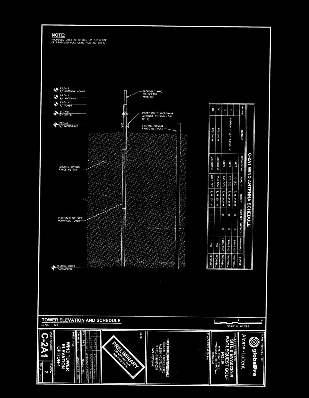
1 City of Surrey PLANNING & DEVELOPMENT REPORT File: Planning Report Date: July 9, 2012 PROPOSAL: Development Variance Permit in order to vary the maximum height of 2 proposed telecommunication monopoles from 12 metres (40 ft.) to 25 metres (82 ft.). LOCATION: Street OWNER: Eagle Quest Golf Centres Inc., Inc. No A ZONING: CPG and CD (By-law No ) OCP DESIGNATION: Agricultural and Suburban
2 Staff Report to Council File: Planning & Development Report Page 2 RECOMMENDATION SUMMARY Approval for Development Variance Permit to proceed to Public Notification. DEVIATION FROM PLANS, POLICIES OR REGULATIONS The proposed telecommunication monopoles require a variance to the Zoning By-law to increase the maximum permitted height for each, from 12 metres (40 ft.) to 25 metres (82 ft.). RATIONALE OF RECOMMENDATION The proposed telecommunication monopoles are located on a golf course and incorporate a stealth design to match the driving range netting poles. Both telecommunication monopoles will be partially screened by existing netting poles, netting and trees. The applicant has examined several alternate locations with the proposed location being the least intrusive. The applicant has worked with staff to reduce the circumference of each pole to 460 millimetres (1.5 feet) diameter and will internalize the antennas, to make them blend with the existing netting poles.
3 Staff Report to Council File: Planning & Development Report Page 3 RECOMMENDATION The Planning & Development Department recommends that: 1. Council approve Development Variance Permit No (Appendix II) varying the following, to proceed to Public Notification: (a) to vary the maximum height of two proposed free-standing telecommunication monopoles from 12 metres (39 ft.) (40 ft.) to 25 metres (82 ft.). REFERRALS Engineering: The Engineering Department has no objection to the project. SITE CHARACTERISTICS Existing Land Use: Eaglequest Golf Course. Adjacent Area: Direction Existing Use OCP Designation Existing Zone North: East: South (Across unopened 76 Avenue): Golf course and low density residential strata development. Single family houses on acreage lots. Suburban CD By-law No Suburban Golf course. Agricultural CPG A-1 (the southernmost lot is under Development Application No proposing 24 small suburban single family lots and open space at Third Reading.) West (Across 152 Street): Golf course and vacant residential lot. Agricultural and Urban CPG, RF and RA DEVELOPMENT CONSIDERATIONS The subject site is the Eaglequest Golf Course located at Street. The site is splitdesignated Agricultural and Suburban in the Official Community Plan (OCP) and splitzoned "Golf Course Zone" (CPG) and Comprehensive Development (CD) Zone (By-law No ).
4 Staff Report to Council File: Planning & Development Report Page 4 The applicant, Wind Mobile, launched its wireless network in the Vancouver market in 2010 and, over time, has been attempting to expand their coverage area in the Lower Mainland, including within the City of Surrey. In April 2010, Wind Mobile submitted an initial Development Variance Permit application to permit the installation of one 25-metre (82 ft.) high telecommunication monopole to be located adjacent to the netting poles that enclose the driving range on the Eaglequest Golf Course on the north edge of the Eaglequest Golf Course (same location as current application, see Site Plan of Appendix II). The proposed monopole was a 25-metre (82 ft.) high, metal, 610 mm (2 ft.) wide pole with 2 microwave dishes. The proposed 25-metre (82 ft.) height was needed to provide an unobstructed visual line of sight for the microwave dish with the E-Comm tower on Fraser Highway. A Development Variance Permit was required as the Zoning By-law limits the height of telecommunication structures to 12 metres (40 ft.). The telecommunication monopole is proposed to be located on the Eaglequest Golf Course site in order for Wind Mobile to be able to provide coverage in the area of generally bound by 144 Street to the west, 168 Street to the east, 64 Avenue to the south and 88 Avenue to the north (Appendix V). A Public Information Meeting (PIM) was held on July 28, 2010 to provide an opportunity for area residents to comment on the proposed telecommunication monopole. In response to concerns raised at the PIM the applicant reduced the diameter of the proposed monopole from 610 millimetres (2 ft.) to 460 millimetres (1.5 ft.) and explored alternate locations for the monopole (Appendix IV). To conform to the co-location requirements of the City s Telecommunication Policy, the applicant proposed to accommodate a second carrier, Mobilicity, that also started service in the Lower Mainland in However, by adding a second carrier, either the monopole height needed to be increased by an additional 7 metres (23 ft.) to 32 metres (105 ft.) (Appendix III) or a second 25-metre (82 ft.) tall monopole needed to be added to the proposal (Appendix II). A second PIM was held on May 17, 2012 to allow area residents to comment on the revised proposal and to provide input into the option of increasing the telecommunication monopole height to 32 metres (105 ft.) to accommodate two carriers or adding a second 25-metre (82 ft.) tall telecommunication monopole for a second carrier (see Public Consultation section). The proposed telecommunication monopoles are not replacing netting poles but will be located approximately one metre (3 ft.) away from the netting on the north side of the driving range. The proposed location is approximately 290 metres (950 ft.) east of 152 Street and 80 metres (262 ft.) away from residences to the north (Appendix II).
5 Staff Report to Council File: Planning & Development Report Page 5 The tallest existing wooden netting pole is approximately 24.4 metres (80 ft.) in height and an existing mature tree, located to the northeast of the proposed monopoles, is approximately 30 metres (98 ft.) tall. These, combined with the existing driving range netting, will partially screen the proposed telecommunication monopoles from the residential areas to the north and north-east. The applicant proposes an equipment compound with a cedar fence to screen the equipment cabinets. The compound will be located on the north side of the equipment shed approximately 120 metres (394 ft.) to the southeast of the proposed monopoles. City s Telecommunication Tower Policy A City policy on telecommunication towers was developed in conjunction with wireless providers and approved by Council on June 18, 2001 (Policy No. O-49 Telecommunication Towers). The policy provides parameters on how the telecommunication towers should be sited and designed. The following is an evaluation of the proposed telecommunication monopoles in relation to Policy No. O-49: Location and Siting When considering the siting of telecommunication tower facilities, every effort should be made to locate new equipment on existing structures such as Hydro transmission towers, utility poles, roof-tops, etc. Although there are Hydro transmission towers in the immediate vicinity, each of these transmission towers has existing antennas. Since BC Hydro has a policy that only one carrier is allowed per tower, the applicant is unable to locate on the transmission towers (see Appendix IV). The applicant has also explored the viability of attaching antennas on 15-metre (49 ft.) high street lights along 152 Street. However, this was not considered a feasible option due to differences in geodetic elevations combined with the maximum street light height of 15 metres (49 ft.). It is preferable that new free-standing telecommunication towers be sited in nonresidential locations and preferably in industrial areas. The proposed locations are on a golf course and are approximately 80 metres (262 ft.) from any residential area. There are no industrial areas in the vicinity. Towers on prominent natural or cultural features, environmentally sensitive areas or areas with historically significant buildings are discouraged. The proposed location of the monopoles is not near any prominent natural or cultural feature, environmentally sensitive area or area with historically significant buildings.
6 Staff Report to Council File: Planning & Development Report Page 6 New free-standing telecommunication towers should be located at a distance from the edge of an existing or future road allowance no less than the height of the tower. The proposed location is approximately 270 metres (886 ft.) east of 152 Street. Location of telecommunication towers on sites with mature trees is encouraged. Co-location The proposed location will be partially screened for some residents to the north by mature trees. The carriers and other telecommunication tower owners are encouraged to work co-operatively in reaching agreements which allow for sharing of tower structures so as to minimize the total number of towers in the City. The applicant has advised that a second carrier on one monopole would require a height of 32 metres (105 ft.). Therefore a second carrier is proposed on a second 25- metre (82 ft.) tall monopole. Tower Design and Landscaping Towers and ancillary equipment shelters will be designed to fit their surroundings and to minimize their visual impact on surrounding properties. Telecommunication equipment will be located along the north of the driving range shed which is on the eastern edge of the driving range. A cedar fence with a hedge is proposed to screen the equipment. The use of a monopole is encouraged. Where a tower is being constructed to accommodate a single user, a monopole design is required. Both proposed towers are a monopole design, intended to resemble the existing wooden netting poles around the driving range. Landscaping shall be appropriately placed around telecommunication tower and ancillary facilities such as equipment shelters to minimize their visual impact on the neighbourhood. As the existing netting poles and driving range netting are not screened with landscaping, landscaping is not proposed around the base of the towers. The proposed equipment compound will be enclosed with a cedar fence and will be screened with hedges. PUBLIC CONSULTATION The initial proposal, submitted on April 19, 2010, was for a single 25-metre (82 ft.) tall telecommunication monopole that was 610 millimetres (2 ft.) in diameter and was to be
7 Staff Report to Council File: Planning & Development Report Page 7 located in the same location adjacent to the netting poles that encloses the driving range on the Eaglequest Golf Course. A Public Information Meeting (PIM) was held at Eaglequest Golf Course on July 7, Approximately 20 area residents attended the PIM with concerns over destroyed views, health issues, and significant drop in property values. As a result of the first PIM, staff requested the applicant to reduce the massing and explore alternate locations. Several locations were explored (see Appendix IV) with none meeting the applicant s needs or without requiring additional pole height. The applicant was able to narrow the monopole by 25 percent from 610 millimetres (2 ft.) to 460 millimetres (1.5 ft.) and better internalize the antennas by using fiberglass sheathing on the top of the metal telecommunication monopole. After the first PIM, the applicant (Wind Mobile) amended the application to include an additional carrier (Mobilicity). The applicant proposed two options, a 32-metre (105 ft.) tall two-carrier monopole (Appendix III) or two 25-metre (82 ft.) tall single-carrier monopoles (Appendix II). As the amended application required either increased height or an additional monopole, it was determined that an additional PIM would be required with neighbouring residents to obtain input on both options. The second PIM was held on May 17, An information package was sent to 41 residents within a 190-metre (623 ft.) radius or six times the height the proposed telecommunication monopole, as measured from the proposed location of the towers, in accordance with Policy No. O-49. The May 17, 2012 PIM was held at Eaglequest Golf Course and 23 residents attended. As a result of the meeting, 10 feedback forms were submitted to City staff at the meeting. City staff also received additional letters from 23 residents. The concerns raised by the residents are as follows (with the applicant s responses in italics): Dissatisfied with the proposed location. The following alternative locations were explored (see Appendix IV for map with approximate elevations): 1. On the clubhouse at Eaglequest Height requirements could not be met and the golf course owner was opposed. 2. Hydro towers Current Hydro policy only allows one carrier per tower. The only available tower falls outside the network s required area. 3. Eaglequest s maintenance shed This location was opposed by some residents and was only marginally feasible from a Radio Frequency engineering perspective. Location was also not supported by the golf course owner. 4. Within the Eaglequest parking lot Pole height would need to be 40 metres (131 ft.) and 760 millimetres in diameter (2.5 ft.) to compensate for the lower topography. In addition, this location was not supported by the golf course owner or by City staff.
8 Staff Report to Council File: Planning & Development Report Page 8 5. Surrey Lake The location was outside the network s required area and not feasible from a Radio Frequency engineering perspective. Topography would require a taller tower. 6. Along the netting pole line on the south side of the driving range - A location near the south side of the golf course was examined however Radio Frequency testing determined that this location had a lower elevation (which would require taller towers) and falls outside of the network requirements. 7. Greenway next to 14 th tee and fairway This location is approximately 8 metres (26 ft.) higher geodetic elevation which would require a shorter tower. Though partially screened by trees the proposed tower would be within 20 metres (66 ft.) of existing residential properties. 8. Netting pole If netting was attached to the proposed poles, additional width would be required to offset the structural loading from netting and related wind load. It was determined that the most suitable location was next to the existing netting poles and to create stealth monopoles to look like netting poles. Dissatisfied with the design. The proposed design options are engineered to be as thin as possible. Diameter was reduced from the 610 millimetres (2 ft.) that was presented at July 14, 2010 Public Information Meeting to 460 millimetres (1.5 ft.). Concerns about depreciation of property values. There is no empirical evidence available that demonstrates that cell phone towers in proximity to homes, or any property, depreciate property values. Concerns that the proposed installation was just a profit generating goal for Wind Mobile, Mobilicity and Eaglequest Golf Course The monopole site will be used by Wind Mobile and Mobilicity to provide cellular network coverage for the community, along with improved 911 public safety access for wireless users. Residents believe that there are already enough wireless providers in the marketplace. The addition of new wireless entrants has led to increased competition in the wireless market. Concerns of electromagnetic files, radiation, and cancer. Industry Canada manages the radio communication spectrum in Canada. Among other requirements, Industry Canada requires cellular telecommunication facilities to comply with guidelines set by Health Canada in order to protect people who live or work near these facilities. These Health Canada safety guidelines are outlined in their
9 Staff Report to Council File: Planning & Development Report Page 9 "Safety Code 6" document and are among the most stringent in the world. All Wind Mobile and Mobilicity facilities meet or exceed these standards. Concern that the applicant s photo simulations did not clearly represent height of proposed options compared to trees and netting poles. In determining the height of the poles and trees the applicant used a bucket truck and a tape measure to determine that the tallest pole is metres (80 ft.) tall. An extrapolation of the tree height was calculated and a laser reading was also used to confirm the height. BY-LAW VARIANCE AND JUSTIFICATION (a) Requested Variance: To increase the maximum height of two free-standing telecommunication monopoles from 12 metres (40 ft.) to 25 metres (82 ft). Applicant s Rationale: Additional height is required for microwave dish to provide line of sight between E- Comm tower on Fraser Highway and the proposed site. Alternate sites have been explored and no other suitable options are possible. The two proposed 25-metre (82 ft.) tall monopoles will be sited beside and resemble the existing 24-metre (79 ft.) high netting poles that border the driving range. Staff Comments: The proposal complies with the majority of criteria identified in the City s Policy for Telecommunication Towers. The proposed monopoles are stealth in design as they mimic the driving range netting poles and the proposed monopoles are partially screened by an existing tree. Staff support the proposed variance. INFORMATION ATTACHED TO THIS REPORT The following information is attached to this Report: Appendix I. Lot Owners and Action Summary Appendix II. Development Variance Permit No Appendix III. Alternative 32-metre (105 ft.) Co-location Design Explored by Applicant Appendix IV. Aerial Map of Vicinity with Alternate Sites Explored
10 Staff Report to Council File: Planning & Development Report Page 10 Appendix V. Coverage Area Based On Proposed Wind Mobile Monopole original signed by Judith Robertson Jean Lamontagne General Manager Planning and Development JKS/kms \\file-server1\net-data\csdc\generate\areaprod\save\ doc. 7/6/12 11:35 AM
11 Page 1 APPENDIX I Information for City Clerk Legal Description and Owners of all lots that form part of the application: 1. (a) Agent: Name: Ian McBean Alcatel Lucent Canada Inc. Address: 4190 Still Creek Rd Burnaby BC V5C 6C6 Tel: Properties involved in the Application (a) Civic Address: Street (b) Civic Address: Street Owner: Eagle Quest Golf Centres Inc., Inc. No A PID: Parcel "One", Except Part in Plan LMP29951 Section 23 Township 2 New Westminster District Plan Summary of Actions for City Clerk's Office (a) Proceed with Public Notification for Development Variance Permit No and bring the Development Variance Permit forward for issuance and execution by the Mayor and City Clerk. document3. 7/6/12 11:35 AM
12 CITY OF SURREY (the "City") DEVELOPMENT VARIANCE PERMIT NO Issued To: EAGLE QUEST GOLF CENTERS INC., INC. NO A (the "Owner") Address of Owner: 1001 United Boulevard Coquitlam, BC V3K 7A7 1. This development variance permit is issued subject to compliance by the Owner with all statutes, by laws, orders, regulations or agreements, except as specifically varied by this development variance permit. 2. This development variance permit applies to that real property including land with or without improvements located within the City of Surrey, with the legal description and civic address as follows: Parcel Identifier: Parcel "One", Except Part in Plan LMP29951 Section 23 Township 2 New Westminster District Plan Street (the "Land") 3. Surrey Zoning By law, 1993, No , as amended is varied as follows: (a) To vary Sub section A.1(a)ii.b. of Part 4 General Provisions, to increase the height of two telecommunications tower from 12 metres (40 ft.) to 25 metres (82 ft.). 4. The siting of buildings and structures shall be in accordance with the drawings numbered (A) through to and including (B) (D) (the Drawings ) which are attached hereto and form part of this development variance permit. 5. This development variance permit applies to only that portion of the buildings and structures on the Land shown on Schedule A which is attached hereto and forms part of this development variance permit. This development variance permit does not apply to additions to, or replacement of, any of the existing buildings shown on attached Schedule A, which is attached hereto and forms part of this development variance permit.
13 The Land shall be developed strictly in accordance with the terms and conditions and provisions of this development variance permit. 76. This development variance permit shall lapse if the Owner does not substantially start any construction with respect to which this development variance permit is issued, within two (2) years after the date this development variance permit is issued. 87. The terms of this development variance permit or any amendment to it, are binding on all persons who acquire an interest in the Land. 99. This development variance permit is not a building permit. AUTHORIZING RESOLUTION PASSED BY THE COUNCIL, THE DAY OF, 20. ISSUED THIS DAY OF, 20. Mayor Dianne L. Watts City Clerk Jane Sullivan \\file server1\net data\csdc\generate\areaprod\save\ doc. 7/9/12 12:16 PM
14
15
 Zoning Boundaries Zoning Boundaries (labels) Rights of")
16 (C) City of Surrey Mapping Online System Legend Lots (Outline) Road Names1000_4000 Park Name Labels Address Points Fish Class (Open Channels) A AO B C Unknown Fish Class (Water Bodies) A AO B C Unknown Water Courses Creek River Greenways In Service Proposed Development Applications Land Use Contracts Land Use Contracts (labels) Zoning Boundaries Zoning Boundaries (labels) Rights of Way Municipal Utility Easements 3rd Party Agreement Restrictive Covenant Easements (labels) Early Copy Lots Anniedale Tynehead Buffer Fish Classifications 30m Suburban Cluster (Green Space Transfer) Low Density Cluster (Green Space Transfer) Medium Density Cluster (Green Space Trans High Density Cluster (Green Space Transfer) Low Density Urban Medium Density Medium High Density High Density Residential Suburban Cluster Low Density Cluster Medium Density Cluster High Density Cluster Special Residential Commercial Neighbourhood Commercial Light Industrial Industrial Business Park Public Assembly Community Centre Kilometers Enter Map Description The data provided is compiled from various sources and is NOT warranted as to its accuracy or sufficiency by the City of Surrey. This information is provided for information and convenience purposes only. Lot sizes, legal descriptions and encumberances must be confirmed at the Land Title Office. Use and distribution of this map is subject to all copyright and disclaimer notices at cosmos.surrey.ca. School Park Trail Scale: 1: 2,000 Landscape Buffer Area Map created on: Riparian July Riparian Enhancement Area
17 Proposal B: 2 25m 1-carrier monopoles GLOBALIVE WIRELESS MANAGEMENT CORPORATION nd St, Surrey GLOBALIVE WIRELESS MANAGEMENT CORPORATION
18 NOTE: ANTENNA MOUNT ORIENTATION C-2B WIND ANTENNA SCHEDULE SECTOR MODEL # TECHNOLOGY AZIMUTH HEIGHT ELEC TILT MECH TILT FREQUENCY STATUS C-2B MOBILICITY ANTENNA SCHEDULE SECTOR MODEL # TECHNOLOGY AZIMUTH HEIGHT ELEC TILT MECH TILT FREQUENCY STATUS TOWER ELEVATION AND SCHEDULE JAL GMA TOWER ELEVATION OPTION-2 C-2B


19 Proposal A: 1 32m / 2 carrier monopole GLOBALIVE WIRELESS MANAGEMENT CORPORATION nd St, Surrey GLOBALIVE WIRELESS MANAGEMENT CORPORATION
 8. Proposed Location of Monopoles (15 metres) 1. On the Clubhouse (13 metres) 3. Maintenance Shed (16 metres) 6. Along Pole Line on South Side of Driving Range (8 metres) 2.")
20 Appendix IV Aerial Photo of Area with Alternate Sites Explored and City of Surrey Mapping Online Approximate Geodetic Elevation of System Each Site 7. Greenway Next to 14th Hole (25 metres) 4. Parking Lot (7 metres) 8. Proposed Location of Monopoles (15 metres) 1. On the Clubhouse (13 metres) 3. Maintenance Shed (16 metres) 6. Along Pole Line on South Side of Driving Range (8 metres) 2. Existing Hydro Tower 5. Surrey Lake (2 metres) Kilometers Enter Map Description The data provided is compiled from various sources and is NOT warranted as to its accuracy or sufficiency by the City of Surrey. This information is provided for information and convenience purposes only. Lot sizes, legal descriptions and encumberances must be confirmed at the Land Title Office. Use and distribution of this map is subject to all copyright and disclaimer notices at cosmos.surrey.ca. Scale: 1: 4,000 Map created on:june-28-12

21
City of Surrey PLANNING & DEVELOPMENT REPORT File:
 City of Surrey PLANNING & DEVELOPMENT REPORT Planning Report Date: June 26, 2017 PROPOSAL: Development Variance Permit to vary the off-street parking requirement to permit placement of one portable classroom
City of Surrey PLANNING & DEVELOPMENT REPORT File:
 City of Surrey PLANNING & DEVELOPMENT REPORT Planning Report Date: May 11, 2015 PROPOSAL: Development Variance Permit in order to permit a total of five (5) fascia signs for an existing Tim Hortons restaurant
Alberta Electric System Operator Needs Identification Document Application. Mowat 2033S Substation
 Decision 21781-D01-2016 Alberta Electric System Operator Needs Identification Document Application Facility Applications September 7, 2016 Alberta Utilities Commission Decision 21781-D01-2016: Alberta
E) That the General Manager be authorized to execute and deliver such documentation on behalf of the Park Board.
 That the General Manager be authorized to execute and deliver such documentation on behalf of the Park Board.") Date: May 30, 2012 TO: Board Members Vancouver Park Board FROM: General Manager Parks and Recreation SUBJECT: Electric Vehicle Charging Stations and Cellular Infrastructure in English Bay Parks RECOMMENDATION
Date: May 30, 2012 TO: Board Members Vancouver Park Board FROM: General Manager Parks and Recreation SUBJECT: Electric Vehicle Charging Stations and Cellular Infrastructure in English Bay Parks RECOMMENDATION
Re: Amend Sections and File No ZA Marcus Lotson, Development Services Planner
 Page 1 To: From: The Planning Commission MPC Staff Date: April 5, 2016 Subject: Re: Amend Sections 8-3082 and 8-3090 Marcus Lotson, Development Services Planner Issue: Proposed amendments to the zoning
ANN ARBOR CITY NOTICE ORDINANCE NO. ORD OFF STREET PARKING CHAPTER 59
 ANN ARBOR CITY NOTICE ORDINANCE NO. ORD-12-04 OFF STREET PARKING CHAPTER 59 AN ORDINANCE TO AMEND SECTIONS 5:168 AND 5:169 OF CHAPTER 59 (OFF- STREET PARKING) OF TITLE V OF THE CODE OF THE CITY OF ANN
Director of Building and Deputy Chief Building Official. 1. North York Community Council approve the request for sign variance at 515 Drewry Avenue.
 STAFF REPORT ACTION REQUIRED Sign Variance 515 Drewry Avenue (New Application & Report) Date: October 19, 2009 To: From: Wards: Reference Number: North York Community Council Director of Building and Deputy
District of Maple Ridge
 District of Maple Ridge TO: His Worship Mayor Ernie Daykin MEETING DATE: March 17, 2014 and Members of Council FILE NO: 2013-096-RZ FROM: Chief Administrative Officer MEETING: COW SUBJECT: Tandem Parking
STAFF REPORT. To: Planning Commission Meeting date: April 12, 2017 Item: UN Prepared by: Robert Eastman
 # 5 ) UN-15-17 LA SIERRA AUTO SALES SPECIAL USE PERMIT VEHICLE SALES PUBLIC HEARING STAFF REPORT To: Planning Commission Meeting date: April 12, 2017 Item: UN-15-17 Prepared by: Robert Eastman GENERAL
Director of Building and Deputy Chief Building Official
 STAFF REPORT ACTION REQUIRED Sign Variance 515 Drewry Avenue Date: September 22, 2009 To: From: Wards: Reference Number: North York Community Council Director of Building and Deputy Chief Building Official
JCP&L Verbatim Response to Middletown Township s Questions
 JCP&L Verbatim Response to Middletown Township s Questions Township officials sent 13 questions about the proposed Monmouth County Reliability Project to JCP&L on June 10 th. JCP&L provided direct responses
BC Hydro Undergrounding for 100 Avenue Widening Between King George Boulevard and 140 Street
 CORPORATE REPORT NO: R191 COUNCIL DATE: September 17, 2018 REGULAR COUNCIL TO: Mayor & Council DATE: September 13, 2018 FROM: General Manager, Engineering FILE: 1717-054/H SUBJECT: BC Hydro Undergrounding
5.12. DOWNTOWN AREA INFILL INCENTIVE DISTRICT (IID)
") 5.12. DOWNTOWN AREA INFILL INCENTIVE DISTRICT (IID) UNIFIED DEVELOPMENT CODE: 5.12.1 Purpose 5.12.1. PURPOSE The primary purpose of the Downtown Area Infill Incentive District (IID) is to encourage redevelopment
5.12. DOWNTOWN AREA INFILL INCENTIVE DISTRICT (IID) UNIFIED DEVELOPMENT CODE: 5.12.1 Purpose 5.12.1. PURPOSE The primary purpose of the Downtown Area Infill Incentive District (IID) is to encourage redevelopment
101, 111 and 129 St. Clair Avenue West Part Lot Control Exemption Application Final Report
 STAFF REPORT ACTION REQUIRED 101, 111 and 129 St. Clair Avenue West Part Lot Control Exemption Application Final Report Date: April 20, 2015 To: From: Wards: Reference Number: Toronto and East York Community
PLANNING JUSTIFICATION REPORT ZONING AMENDMENT
 PLANNING JUSTIFICATION REPORT ZONING AMENDMENT Proposed Expansion of Mercedes-Benz Motor Vehicle Dealership 441 North Service Road, Burlington, Ontario December 2016 Prepared for: Mr. Ken Szekely Quantum
Technical Memorandum. To: From: Date: October 14 th, 2018 Project #: 1302 Project Name: Subject: Distribution:
 Technical Memorandum To: Tom Hanrahan Jeff Sharp From: Date: October 14 th, 2018 Project #: 1302 Project Name: Subject: Distribution: Barrie Lockhart Road LP Conformity Review Scott Young Sorbara Group
Driveway Entrance Policy for Residential Properties - District 3 - All Wards
 Driveway Entrance Policy for Residential Properties - District 3 - All Wards (City Council on August 1, 2, 3 and 4, 2000, adopted this Clause, without amendment.) The North York Community Council recommends
Section 2. Definitions
 Section 2 Definitions Words used in this By-law shall have the meaning assigned to them by sections 2, 9 and 10.5 of the Zoning and Development By-law unless otherwise stated and except as provided below.
Prince George CNG Operations and Maintenance Facility Project BC Transit
 Prince George CNG Operations and Maintenance Facility Project BC Transit Prepared by March 16, 2017 March 16, 2017 Prince George Transit Operations and Maintenance CNG Facility Project Page 1 TABLE OF
Attachment D Environmental Justice and Outreach
 Attachment D Environmental Justice and Outreach ATTACHMENT D Environmental Justice and Outreach Indicate whether the project will have disproportionately high and adverse impacts on minority or low income
CITY OF DECATUR, TEXAS Development Services 1601 S. State Street Decatur, TX (940) voice (940) fax
 voice (940) fax") CITY OF DECATUR, TEXAS Development Services 1601 S. State Street Decatur, TX 76234 (940) 393-0250 voice (940) 626-4629 fax AGENDA Planning and Zoning Commission and City Council Joint Workshop* Monday,
CITY OF DECATUR, TEXAS Development Services 1601 S. State Street Decatur, TX 76234 (940) 393-0250 voice (940) 626-4629 fax AGENDA Planning and Zoning Commission and City Council Joint Workshop* Monday,
/ Planning and Zoning Staff Report Lonestar Land, LLC. - Rezone, RZ
 / Planning and Zoning Staff Report Lonestar Land, LLC. - Rezone, RZ2018-0019 Hearing Date: October 18, 2018 Development Services Department Applicant: Lonestar Land, LLC. Representative: Lance Warnick
Update on Community or Heritage Rail Project (Project Manager Services) The Engineering Department recommends that Council:
 The Engineering Department recommends that Council:") Corporate NO: R279 Report COUNCIL DATE: DECEMBER 18, 2006 REGULAR COUNCIL TO: Mayor & Council DATE: December 15, 2006 FROM: General Manager, Engineering FILE: 8710-20 (Heritage) SUBJECT: Update on Community
Corporate NO: R279 Report COUNCIL DATE: DECEMBER 18, 2006 REGULAR COUNCIL TO: Mayor & Council DATE: December 15, 2006 FROM: General Manager, Engineering FILE: 8710-20 (Heritage) SUBJECT: Update on Community
Planning Commission Staff Report Ordinance Amendment Hearing Date: November 14, 2018
 Planning Commission Staff Report Ordinance Amendment Hearing Date: November 14, 2018 ITEM # 1* Western Community Crossroads LC requests an Ordinance Text amendment to Section 14.34.350 Recreational Vehicle
Operations Center FAQs
 RICHARDSON INDEPENDENT SCHOOL DISTRICT Where all students learn, grow and succeed Operations Center FAQs Richardson ISD is constructing an operations center on vacant district land between Greenville Avenue
REGIONAL DISTRICT OF OKANAGAN-SIMILKAMEEN BYLAW NO , A Bylaw to amend the Electoral Area H Zoning Bylaw No.
 BYLAW NO. 2498.08 REGIONAL DISTRICT OF OKANAGAN-SIMILKAMEEN BYLAW NO. 2498.08, 2016 A Bylaw to amend the Electoral Area H Zoning Bylaw No. 2498, 2012 The REGIONAL BOARD of the Regional District of Okanagan-Similkameen
Pre-submission Consultation $ Telecommunications Tower Approval 7,700.00
 Planning Application Processing Fees Schedule of Application Fees In addition to the fees identified below, there may be additional fees charged by other City Departments or agencies, such as Engineering
DATE: March 21, 2017 REPORT NO. PW TYPE OF REPORT CONSENT ITEM [ ] ITEM FOR CONSIDERATION [ X ] 2.0 TOPIC
![DATE: March 21, 2017 REPORT NO. PW TYPE OF REPORT CONSENT ITEM [ ] ITEM FOR CONSIDERATION [ X ] 2.0 TOPIC](/thumbs/88/115267053.jpg "DATE: March 21, 2017 REPORT NO. PW TYPE OF REPORT CONSENT ITEM [ ] ITEM FOR CONSIDERATION [ X ] 2.0 TOPIC") PUBLIC WORKS COMMISSION PUBLIC WORKS COMMISSION DATE: March 21, 2017 REPORT NO. PW2017-022 TO: FROM: Chair and Members Committee of the Whole Operations and Administration E. (Beth) Goodger, General Manager
PUBLIC WORKS COMMISSION PUBLIC WORKS COMMISSION DATE: March 21, 2017 REPORT NO. PW2017-022 TO: FROM: Chair and Members Committee of the Whole Operations and Administration E. (Beth) Goodger, General Manager
Chair and Members, The Etobicoke York Community Council. Mark Sraga, Director and Deputy Chief Building Official
 STAFF REPORT ACTION REQUIRED Sign Variance Report 10 Marmac Drive Date: February 20, 2010 To: From: Chair and Members, The Etobicoke York Community Council Mark Sraga, Director and Deputy Chief Building
WOLVERINE TO BHP JANSEN NEW TRANSMISSION LINE PROJECT FALL 2017
 WOLVERINE TO BHP JANSEN NEW TRANSMISSION LINE PROJECT FALL 2017 TODAY WE LL TALK ABOUT Our challenges and how we re meeting them Why we re building this project Our planning process and considerations
The following uses and no others are permitted in this zone: Civic Commercial, limited to:
 PART 20 INSTITUTIONAL ZONES 2001 P-1 Civic Institutional (1) Intent This zone provides for uses of an educational, governmental or institutional nature which provide services to the public. Commercial
Public and Fleet Electric Vehicle Charging Infrastructure Strategy
 CoQuitlam For Council Our File: 11-5210-01/000/2018-1 Doc#: 3187569.V3 To: From: Subject: For: City Manager General Manager, Engineering and Public Works Public and Fleet Electric Vehicle Charging Infrastructure
This page is intentionally left blank.
 This page is intentionally left blank. Bipole III Southern Ground Electrode Line Route Selection Introduction Manitoba Hydro has recently selected a route for the southern ground electrode line (Map 1).
Attachment 5 Eglinton West LRT Planning and Technical Update
 Eglinton West LRT Planning and Technical Update 1. Introduction In July 2016, City Council approved an Eglinton West LRT with between 8 and 12 stops between Mount Dennis and Renforth Gateway, and up to
Plan Check Policies and Guidelines
 Plan Check Policies and Guidelines VII. A. INTRODUCTION Traffic signing and striping plans are required for all General Plan Roads and any roadway that is 56-foot wide curb-to-curb (78 R/W) or wider. Transportation
TRANSPORTATION REVIEW
 TRANSPORTATION REVIEW - PROPOSED MIX OF LAND USES IS CONSISTENT WITH THE CITY S UNDER THE GRANVILLE BRIDGE POLICIES THAT AIM TO MEET NEIGHBOURING RESIDENTS SHOPPING NEEDS AND REDUCE RELIANCE ON AUTOMOBILE
The minimum number of accessory off-street parking spaces. shall conform to the requirements of the Table of General
 ARTICLE VII Parking and Loading 1. Conformity with Use Table; exceptions. The minimum number of accessory off-street parking spaces shall conform to the requirements of the Table of General Use Regulations,
The Engineering Department recommends Council receive this report for information.
 CORPORATE REPORT NO: R161 COUNCIL DATE: July 23, 2018 REGULAR COUNCIL TO: Mayor & Council DATE: July 19, 2018 FROM: General Manager, Engineering FILE: 8740-01 SUBJECT: Surrey Long-Range Rapid Transit Vision
3434 SEACLOUD ROAD $629,000. Special Features: BRIAN DANYLIW & ASSOCIATES Personal Real Estate Corporation. Direct TF
 3434 SEACLOUD ROAD $629,000 Special Features: 4838sq. ft. Finished 1.07Acres Fenced 5 Bedroom 5 Baths Ocean Views 3 Fireplaces Master Bedroom on Main Mature Gardens Backyard Labyrinth DESCRIPTION A beautiful
Project Title: Lowertown Ballpark (CHS Field) Solar Arrays Contract Number: EP4-34 Milestone Number: 1 Report Date: June 21, 2016
 Solar Arrays Contract Number: EP4-34 Milestone Number: 1 Report Date: June 21, 2016") DEPARTMENT OF PARKS AND RECREATION DESIGN AND CONSTRUCTION CITY OF SAINT PAUL Mayor Christopher B. Coleman 400 City Hall Annex 25 West 4 th Street Saint Paul, Minnesota 55102 www.stpaul.gov/parks Telephone:
DEPARTMENT OF PARKS AND RECREATION DESIGN AND CONSTRUCTION CITY OF SAINT PAUL Mayor Christopher B. Coleman 400 City Hall Annex 25 West 4 th Street Saint Paul, Minnesota 55102 www.stpaul.gov/parks Telephone:
DRIVEWAY/APPROACH PERMIT APPLICATION Applicant Type: Architect/Engineer Contractor Owner
 DRIVEWAY/APPROACH PERMIT APPLICATION Applicant Type: Architect/Engineer Contractor Owner Lake Elmo City Hall 651-747-3900 3880 Laverne Avenue North Lake Elmo, MN 55042 Project Address: Property Owner:
Small What? A look into Small Cell Facilities and how communities can regulate them
 What is a Small Cell Facility Small What? A look into Small Cell Facilities and how communities can regulate them Elizabeth Fields, AICP McBride Dale Clarion Agenda 1. What is a Small Cell? 2. FAQ 3. History
Decision D ATCO Electric Ltd. Decommissioning of Transmission Line 6L82
 Decision 21447-D01-2016 August 23, 2016 Decision 21447-D01-2016 Proceeding 21447 Application 21447-A001 August 23, 2016 Published by the: Fifth Avenue Place, Fourth Floor, 425 First Street S.W. Calgary,
BOARD OF ZONING ADJUSTMENT STAFF REPORT Date: November 7, 2016
 # 2 HOLDOVER Revised ZON2016-01992 BOARD OF ZONING ADJUSTMENT STAFF REPORT Date: November 7, 2016 CASE NUMBER 6065 APPLICANT NAME LOCATION VARIANCE REQUEST ZONING ORDINANCE REQUIREMENT ZONING AREA OF PROPERTY
DR SE WAY SOMERSIDE. C-N Neighborhood Commercial Site. R-LD - Development in accordance. Fully Landscaped Park/ Playground.
 LAND & BUSINESS SUPPORT DEPT Southlands Phase 6A Plan 01231 City of Medicine Hat Land & Business Support Ph (03) 52-1 Fax (03) 502-055 land_properties@medicinehat.ca updated August 20, 201 SOMERSET BAY
CASE NUMBER: 15SN0627 APPLICANT: Stafford H. Cassell
 CASE NUMBER: 15SN0627 APPLICANT: Stafford H. Cassell STAFF S ANALYSIS AND RECOMMENDATION CHESTERFIELD COUNTY, VIRGINIA Magisterial District: CLOVER HILL Board of Supervisors (BOS) Public Hearing Date:
Purpose: General Provisions:
 10-19-1 Purpose: The purpose of off-street parking requirements is to promote traffic/pedestrian safety and efficiency and to minimize hard surfaced areas to reduce storm water run-off and visual impacts
Green Line LRT: Beltline Recommendation Frequently Asked Questions
 Green Line LRT: Beltline Recommendation Frequently Asked Questions June 2017 Quick Facts Administration has evaluated several alignment options that would connect the Green Line in the Beltline to Victoria
City of Lafayette Staff Report Circulation Commission
 City of Lafayette Staff Report Circulation Commission Meeting Date: September 5, 2016 Staff: Subject: James Hinkamp, Transportation Planner Consideration of a No Parking Zone on Victoria Avenue Summary
January 11, 2019 AUTO RELATED USES ZONING TEXT AMENDMENT. Dear Owner or Manager:
 January 11, 2019 RE: AUTO RELATED USES ZONING TEXT AMENDMENT Dear Owner or Manager: Last year the City Council considered revisions to the zoning standards for auto related uses (auto sales, auto repair,
Condition of Approval Building Standards Development Planning Engineering TRCA PowerStream Ministry of Transportation Other -
 File: A207/14 Item # 19 Ward #3 Applicant: MARCO AND LUCIA UNCAO Address: Agent: 27 Templewood Crescent, Woodbridge NONE Adjournment Status: Notes: Comments/Conditions: Commenting Department Comment Condition
Access Management Standards
 Access Management Standards This section replaces Access Control Standards on Page number 300-4 of the Engineering Standards passed February 11, 2002 and is an abridged version of the Access Management
STAFF REPORT FOR THE PLANNING COMMISSION MEETING OF JULY 29, 2009 FILE NO: ZCA AGENDA ITEM: H-4
 STAFF REPORT FOR THE PLANNING COMMISSION MEETING OF JULY 29, 2009 FILE NO: ZCA-09-057 AGENDA ITEM: H-4 STAFF AUTHOR: Lee Plemel, Planning Director APPLICANT: Carson City Planning Division SUBJECT: Action
Welcome. Green Line in Your Community
 Welcome Green Line in Your Community Today's session will provide you with information about Administration's recommendation for connecting the Green Line in the Beltline to Victoria Park and Inglewood/Ramsay
IV. ENVIRONMENTAL IMPACT ANALYSIS K.2. PARKING
 IV. ENVIRONMENTAL IMPACT ANALYSIS K.2. PARKING ENVIRONMENTAL SETTING The following analysis summarizes the findings and conclusions of the Traffic Analysis (Traffic Study), prepared by The Mobility Group,
POLICIES FOR THE INSTALLATION OF SPEED HUMPS (Amended May 23, 2011)
") (Amended May 23, 2011) 1. Speed humps are an appropriate mechanism for reducing speeds on certain streets in Pasadena when properly installed under the right circumstances. 2. Speed humps can be considered
(Amended May 23, 2011) 1. Speed humps are an appropriate mechanism for reducing speeds on certain streets in Pasadena when properly installed under the right circumstances. 2. Speed humps can be considered
Plan Check Policies and Guidelines
 VIII. TRAFFIC SIGNING AND STRIPING PLANS A. INTRODUCTION Traffic signing and striping plans are required for all General Plan Roads and any roadway that is 56-foot wide curb-to-curb (78 R/W) or wider.
On June 11, 2012, the Park Board approved the installation of three electric vehicle charging stations along Beach Avenue.
 January 8, 2017 TO: Park Board Chair and Commissioners FROM: General Manager Vancouver Board of Parks and Recreation SUBJECT: Electric Vehicle Charging Stations New Park Board Locations RECOMMENDATION
Temporary Sales Trailer Application
 Development Services Department Building Division 311 Vernon Street Roseville, California 95678-2649 Temporary Sales Trailer Application General: Requests for temporary sales trailers, which comply with
Plumas County Record of Surveys
 Plumas County Record of Surveys Guidelines & Submittal Requirements 1 Office of the County Engineer Guide to processing a Record of Survey When Required 1) When a material evidence or physical change,
Bohn to Kettle River Transmission Project
 April 2012 Why are you receiving this project information package? New transmission facilities are needed in the Fort McMurray area. ATCO Electric has been directed by the Alberta Electric System Operator
2012 Water Consumption Statistics Report. Water Services Department
 212 Water Consumption Statistics Report Water Services Department Issued: December 213 TABLE OF CONTENTS 212 Water Consumption Statistics Report December 213 212 GVWD Statistics Book - Notes...3 Annual
FREQUENTLY ASKED QUESTIONS
 THE PROJECT Last updated on 2/19/16 FREQUENTLY ASKED QUESTIONS What s happening on Highway 169? The Minnesota Department of Transportation (MnDOT) is planning to rebuild and repair the infrastructure on
Public Works and Infrastructure Committee. p:/2015/clusterb/tra/northyork/pw15086
 PW9.10 STAFF REPORT ACTION REQUIRED Car-Share Parking in Permit Parking Areas Date: October 22, 2015 To: From: Wards: Reference Number: Public Works and Infrastructure Committee General Manager, Transportation
TANDEM AND OFF-STREET PARKING DISCUSSION PAPER 2013
 TANDEM AND OFF-STREET PARKING DISCUSSION PAPER 2013 1. Tandem Parking Study: identified in the 2013 Planning Department Business Plan; 2. Triggered by several recent townhouse development applications
11 October 12, 2011 Public Hearing APPLICANT:
 11 October 12, 2011 Public Hearing APPLICANT: CARING TRANSITIONS PROPERTY OWNER: HARDEE REALTY CORPORATION REQUEST: Conditional Use Permit (motor vehicle rental) STAFF PLANNER: Leslie Bonilla ADDRESS /
welcome to the BC Hydro community open house
 welcome to the BC Hydro community open house Dawson Creek/ Chetwynd Area Transmission ProjecT Open House welcome Dawson Creek/Chetwynd Area Transmission Project (DCAT) The purpose of this open house is
Proposed Zoning Bylaw Text Amendments Pertaining to Electric Vehicle Charging Infrastructure Requirements (Bylaw No. 4905,2018)
") CoQuitlam For Council September 10, 2018, Our file: 08-3360-20/18 118298 RZ/l Doc#: 3032571.VI To: From; Subject: For: City Manager Director Development Services Proposed Zoning Bylaw Text Amendments Pertaining
CoQuitlam For Council September 10, 2018, Our file: 08-3360-20/18 118298 RZ/l Doc#: 3032571.VI To: From; Subject: For: City Manager Director Development Services Proposed Zoning Bylaw Text Amendments Pertaining
Welcome to: PUBLIC OPEN HOUSES MARCH 22 AND 25, 2004 GENERAL LAND USE PLAN. Please take some time to read through this presentation.
 Welcome to: GENERAL LAND USE PLAN PUBLIC OPEN HOUSES MARCH 22 AND 25, 2004 Please take some time to read through this presentation. Feel free to ask questions and provide any ideas, opinions or comments
5 June 12, 2013 Public Hearing APPLICANT: BARTON HERITAGE, LLC T/A SANDBRIDGE BEACH BUGGIES PROPERTY OWNER: LOWER 40, LLC
 REQUEST: Conditional Use Permit (motor vehicle rentals low speed vehicles) ADDRESS / DESCRIPTION: 3713 Sandpiper Road 5 June 12, 2013 Public Hearing APPLICANT: BARTON HERITAGE, LLC T/A SANDBRIDGE BEACH
Technical Memorandum
 To: Copy: From: Wally Dubyk Jennifer Murray André Sponder/Christopher Gordon, P.Eng. Re: Southminster Church 1040 Bank Street Residential Development Parking Review Technical Memorandum Date: Project:
CONCEPTUAL UTILITY REPORT FOR THE CANYONS PHASE 1 CITY OF CASTLE PINES, CO
 CONCEPTUAL UTILITY REPORT FOR THE CANYONS PHASE 1 CITY OF CASTLE PINES, CO PREPARED FOR: SHEA HOMES 9380 STATION ST., SUITE 600 LONE TREE, CO 80124 PHONE: 303-791-8180 CONTACT: RYAN MCDERMED PREPARED BY:
±25,934 SF C-3 ZONED PAD
 ±25,934 SF C-3 ZONED PAD SOUTH 5TH AVENUE, TUCSON, ARIZONA CONTACT US DAVE VOLK Vice President +1 520 323 5102 david.volk@cbre.com BRUCE SUPPES Vice President +1 520 323 5155 bruce.suppes@cbre.com PROPERTY
MAP OR PHOTO. Public Meeting & Open House July 23, Project Roadway Limits From: FM 1957 To: FM 471. Counties Bexar & Medina
 Public Meeting & Open House July 23, 2013 Project Roadway Limits From: FM 1957 To: FM 471 MAP OR PHOTO Counties Bexar & Medina 1 I. Project History II. III. IV. Project Overview Project Alternatives Response
Downtown Lee s Summit Parking Study
 Downtown Lee s Summit Parking Study As part of the Downtown Lee s Summit Master Plan, a downtown parking and traffic study was completed by TranSystems Corporation in November 2003. The parking analysis
Study Report. McCredie-Overton Transmission Line Right-of-Way Analysis. City of Columbia, Missouri. prepared for the (S49)
") Study Report McCredie-Overton Transmission Line Right-of-Way Analysis prepared for the City of Columbia, Missouri (S49) May, 2017 S49 McCredie-Overton Transmission Line Right-of-Way Study Report Table
Study Report McCredie-Overton Transmission Line Right-of-Way Analysis prepared for the City of Columbia, Missouri (S49) May, 2017 S49 McCredie-Overton Transmission Line Right-of-Way Study Report Table
Parking Areas and Driveways for Single and Two Family Dwellings
 Building Information BURNABY PLANNING AND BUILDING DEPARTMENT Parking Areas and Driveways for The purpose of this brochure is to explain to owners, designers and builders the parking and driveway requirements
Decision D ATCO Electric Ltd. Decommissioning of Transmission Line 6L79. October 18, 2016
 Decision 21481-D01-2016 October 18, 2016 Alberta Utilities Commission Decision 21481-D01-2016 Proceeding 21481 Application 21481-A001 October 18, 2016 Published by the: Alberta Utilities Commission Fifth
Kettle River Transmission Project
 April 2012 Why are you receiving this project information package? New transmission facilities are needed in the Fort McMurray area. ATCO Electric has been directed by the Alberta Electric System Operator
ADOPT INTERCONNECTION AGREEMENT FORMS FOR CUSTOMERS INSTALLING GENERATION EQUIPMENT PURSUANT TO REGULATION 23.
 TO: Honorable Mayor and City Council THROUGH: Municipal Services Committee (May 10, 2016) FROM: SUBJECT: Water and Power Department ADOPT INTERCONNECTION AGREEMENT FORMS FOR CUSTOMERS INSTALLING GENERATION
DEVELOPMENT PROPERTY 1627 MAXIME STREET CITY OF OTTAWA TRANSPORTATION OVERVIEW. Prepared for: Subhas Bhargava. July 9, Overview_1.
 DEVELOPMENT PROPERTY 1627 MAXIME STREET CITY OF OTTAWA TRANSPORTATION OVERVIEW Prepared for: Subhas Bhargava July 9, 2015 115-620 Overview_1.doc D. J. Halpenny & Associates Ltd. Consulting Transportation
DRIVEWAY STANDARDS EXHIBIT A. The following definition shall replace the definition of driveway in Section 62:
 1365 S. Camino del Rio Durango, CO 81303 970-382-6363 DRIVEWAY STANDARDS Resolution 2014-40 EXHIBIT A The following definition shall replace the definition of driveway in Section 62: Driveway means a roadway,
Public Information Workshop
 Public Information Workshop Charlotte County-Punta Gorda MPO - Meeting Rooms A and B March 29, 2018 Welcome to the Public Information Workshop for Harborview Road Project Development and Environment (PD&E)
Alberta Aerotropolis Overview Booklet Prepared for the Leduc Partnership (City of Leduc & Leduc County)
") Alberta Aerotropolis Overview Booklet Prepared for the Leduc Partnership (City of Leduc & Leduc County) by MXD Development Strategists / Stantec June 2015 WHAT IS AN AEROTROPOLIS? An Aerotropolis is a
Alberta Aerotropolis Overview Booklet Prepared for the Leduc Partnership (City of Leduc & Leduc County) by MXD Development Strategists / Stantec June 2015 WHAT IS AN AEROTROPOLIS? An Aerotropolis is a
FREQUENTLY ASKED QUESTIONS
 THE PROJECT Last updated on 9/8/16 FREQUENTLY ASKED QUESTIONS What s happening on Highway 169? The Minnesota Department of Transportation (MnDOT) is planning to rebuild and repair the infrastructure on
Town of Vermont Driveway Permit Ordinance
 Town of Vermont Driveway Permit Ordinance 4.00 TITLE AND PURPOSE The title of this ordinance is the Town of Vermont Driveway Permit Ordinance. The purpose is to regulate the establishment, repair, construction,
4 SPEED LIMIT REVISIONS ON REGIONAL ROADS
 Report No. 4 of the Transportation Services Committee Regional Council Meeting of April 19, 2012 4 SPEED LIMIT REVISIONS ON REGIONAL ROADS The Transportation Services Committee recommends the adoption
ARTICLE 8 OFF-STREET PARKING AND PRIVATE DRIVEWAY STANDARDS
 ARTICLE 8 OFF-STREET PARKING AND PRIVATE DRIVEWAY STANDARDS TABLE OF CONTENTS SECTION PAGE 8.1 GENERAL STANDARDS...8-2 8.2 PRIVATE DRIVEWAY PROVISIONS...8-4 8.3 OFF-STREET PARKING STANDARDS...8-5 8.4 OFF-STREET
CITY CLERK. Warrants for All-Way Stop Sign Control and 40 km/h Maximum Speed Limits
 CITY CLERK Clause embodied in Report No. 9 of the, as adopted by the Council of the City of Toronto at its Special Meeting held on July 30, 31 and August 1, 2002. 10 Warrants for All-Way Stop Sign Control
REPORT TO THE CHIEF ADMINISTRATIVE OFFICER FROM THE DEVELOPMENT AND ENGINEERING SERVICES DEPARTMENT
 REPORT TO THE CHIEF ADMINISTRATIVE OFFICER FROM THE DEVELOPMENT AND ENGINEERING SERVICES DEPARTMENT ON April 3, 2014 ZONING BYLAW AMENDMENT APPLICATION NO. ZBA00079 CHANGES TO THE ZONING AND BUSINESS LICENCE
West LRT. Alignment Update and Costing Report May Calgary Transit Transportation Planning Clifton ND Lea Consultants
 West LRT Alignment Update and Costing Report 2006 May Calgary Transit Transportation Planning Clifton ND Lea Consultants West LRT Update Background The service area for West LRT is generally described
Electric system improvements near you
 Electric system improvements near you Red Deer Area Transmission Development Stage 1 substation upgrades April 2011 Volume 1 Did you know? The average four-person family in Alberta today has 20 instant-on
APPENDIX VMT Evaluation
 APPENDIX 2.7-2 VMT Evaluation MEMORANDUM To: From: Mr. Jonathan Frankel New Urban West, Incorporated Chris Mendiara LLG, Engineers Date: May 19, 2017 LLG Ref: 3-16-2614 Subject: Villages VMT Evaluation
Requests Conditional Use Permit (Open Air Market) Staff Recommendation Approval. Staff Planner Kristine Gay
 Staff Recommendation Approval. Staff Planner Kristine Gay") Applicant Property Owner Runnymede Corp. Public Hearing April 12, 2017 City Council Election District Beach Agenda Item 10 Requests Conditional Use Permit (Open Air Market) Staff Recommendation Approval
Applicant Property Owner Runnymede Corp. Public Hearing April 12, 2017 City Council Election District Beach Agenda Item 10 Requests Conditional Use Permit (Open Air Market) Staff Recommendation Approval
Parking Management Element
 Parking Management Element The State Transportation Planning Rule, adopted in 1991, requires that the Metropolitan Planning Organization (MPO) area implement, through its member jurisdictions, a parking
Executive Summary EXECUTIVE SUMMARY Parking Issues Trenton Downtown Parking Policy and Sidewalk Design Standards E.S. Page 1 Final Report 2008
 EXECUTIVE SUMMARY A walkable environment that accommodates market demand while minimizing the negative impacts of growth is an important element in promoting the City s downtown revitalization. There are
Proposed Parking Strategy for Existing New Urbanism Areas. Committee of the Whole (Working Session) December 3, 2013
 December 3, 2013") Proposed Parking Strategy for Existing New Urbanism Areas Committee of the Whole (Working Session) December 3, 2013 Objective of Today s Presentation Seek Committee input prior to consultation with residents
Proposed Parking Strategy for Existing New Urbanism Areas Committee of the Whole (Working Session) December 3, 2013 Objective of Today s Presentation Seek Committee input prior to consultation with residents
appendix 4: Parking Management Study, Phase II
 appendix 4: Parking Management Study, Phase II A4-1 A4-2 Eastlake Parking Management Study Final Phase 2 Report Future Parking Demand & Supply January 6, 2017 Submitted by Denver Corp Center III 7900 E.
Requirements for Secondary Voltage Revenue Metering (750 V and less)
") Requirements for Secondary Voltage Revenue Metering (750 V and less) To view the latest revision of this document go to: http://www.bchydro.com/ext/metering/ January 28, 2010 Copyright 2008 by BC Hydro.
Requirements for Secondary Voltage Revenue Metering (750 V and less) To view the latest revision of this document go to: http://www.bchydro.com/ext/metering/ January 28, 2010 Copyright 2008 by BC Hydro.
best to you all Gail Carbiener Page 1 of 5
 Please accept this attachment as my up dated response to the B2H DEIS. If this is not acceptable, please let me know. Nice meeting last Monday in Boardman. 300316 best to you all Gail Carbiener 2 Page