2015%Island%City%Academy%Basketball%Schedule%
|
|
|
- Violet Holt
- 5 years ago
- Views:
Transcription
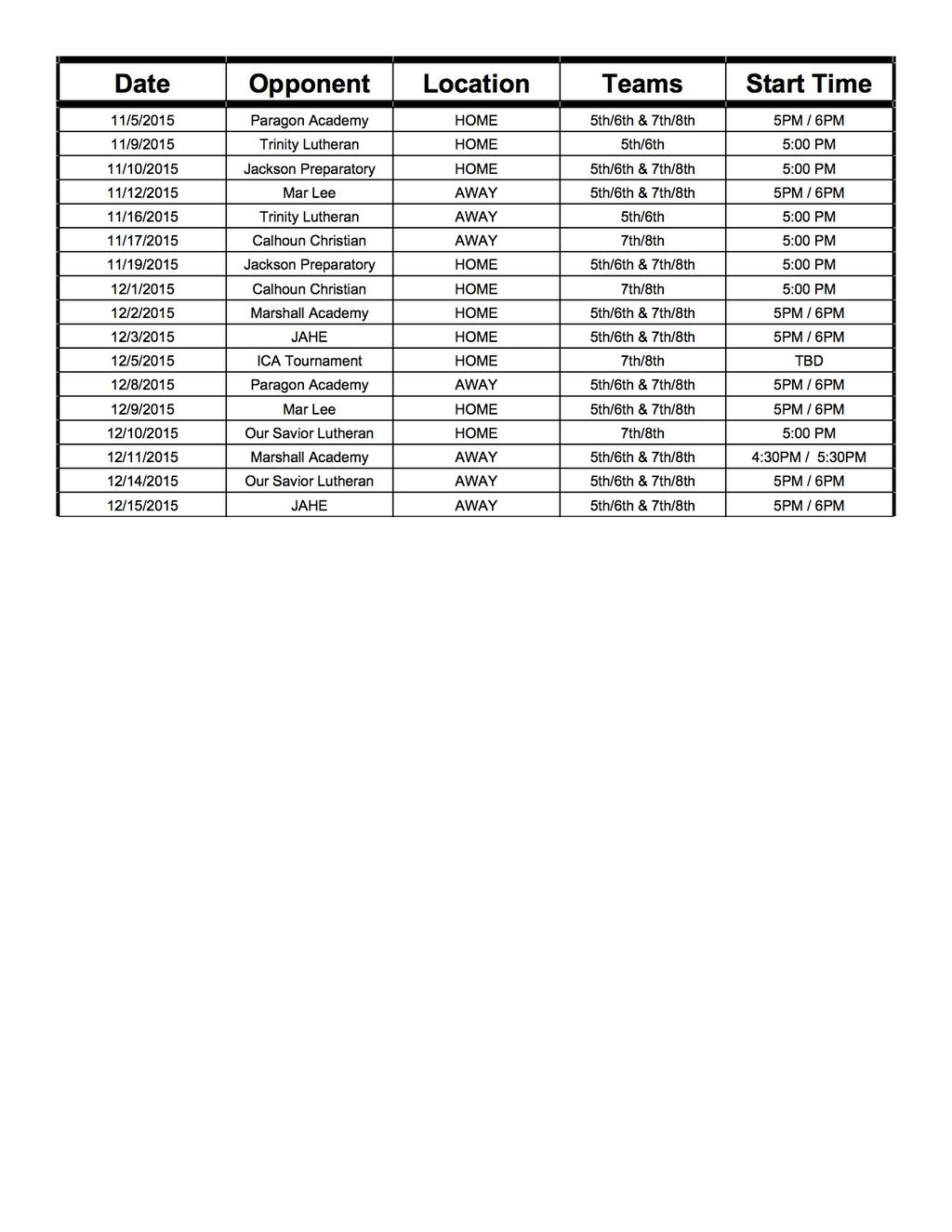


1 ! 2015%Island%City%Academy%Basketball%Schedule%!!!

2 9/3/2015 to Mar Lee School, Marshall, MI - Google Maps to Mar Lee School, Marshall, MI Drive 23.7 miles, 29 min 2 mi Take E Bellevue Hwy and 23 Mile Rd to H Dr N in Marengo 1. Head south on M-50 E/M-99 S toward Springbrook Dr 2. Turn right onto E Bellevue Hwy 3. Turn left onto S Cochran Ave 4. Turn right onto E Baseline Rd 5. Turn left onto 23 1/2 Mile Rd 6. Turn right onto V-Drive N 7. Continue straight to stay on V-Drive N 8. Turn left onto 23 Mile Rd 9. Continue onto I-Drive N 1.7 mi 9.6 mi 2.0 mi 0.1 mi 1.0 mi 0.5 mi 233 ft 6.5 mi 0.2 mi 1/2
3 9/3/2015 to Mar Lee School, Marshall, MI - Google Maps 10. Continue onto 22 1/2 Mile Rd 11. Turn right onto H Dr N 0.4 mi 1.6 mi Mar Lee School Marshall, MI results, and you should plan your route accordingly. You must obey all signs or notices regarding your route. 2/2

4 9/3/2015 to Trinity Lutheran School - Google Maps to Trinity Lutheran School Drive 22.2 miles, 27 min 2 mi 1. Head south on M-50 E/M-99 S toward Springbrook Dr 2. Slight left onto M-50 E 3. Turn right onto Blackman Rd 4. Turn right onto W Michigan Ave 5. Turn left onto O'Brien Rd 6. Turn left onto McCain Rd Destination will be on the left 3.6 mi 11.3 mi 5.3 mi 0.4 mi 1.5 mi 0.2 mi Trinity Lutheran School 4900 McCain Road, Jackson, MI /2


5 9/3/2015 to Calhoun Christian School - Google Maps to Calhoun Christian School Drive 41.6 miles, 48 min 5 mi Take E Bellevue Hwy, I-69 S and I-94 W to E Territorial Rd in Battle Creek 1. Head south on M-50 E/M-99 S toward Springbrook Dr 2. Turn right onto E Bellevue Hwy 3. Slight left onto N Main St 4. Turn right at the 1st cross street onto Kalamo St 5. Continue onto Ainger Rd 44 min (40.2 mi) 6. Turn left to merge onto I-69 S toward Ft Wayne 1.7 mi 13.7 mi 0.3 mi 0.6 mi 0.3 mi 11.9 mi 1/2

6 9/3/2015 to Calhoun Christian School - Google Maps 7. Take exit 38 to merge onto I-94 W toward Chicago 8. Take exit 100 for M-294/Beadle Lake Rd 9. Turn right onto M-294 N/Beadle Lake Rd Continue to follow M-294 N 10. Turn left onto M-96 W/E Columbia Ave 11. Turn right onto Riverside Dr 8.6 mi 0.2 mi 1.4 mi 1.0 mi 0.4 mi Follow E Territorial Rd to Woodrow Ave S 12. Turn left onto E Territorial Rd 13. Turn left onto Woodrow Ave S Destination will be on the right 4 min (1.5 mi) 1.4 mi 0.1 mi Calhoun Christian School 20 Woodrow Avenue South, Battle Creek, MI results, and you should plan your route accordingly. You must obey all signs or notices regarding your route. 2/2

7 9/3/2015 to Paragon Academy - Google Maps to Paragon Academy Drive 23.3 miles, 29 min 2 mi 1. Head south on M-50 E/M-99 S toward Springbrook Dr 2. Slight left onto M-50 E 3. Turn right onto Blackman Rd 4. Turn right onto W Michigan Ave 5. Turn left onto O'Brien Rd 6. Turn left onto McCain Rd Destination will be on the left 3.6 mi 11.3 mi 5.3 mi 0.4 mi 1.5 mi 1.3 mi Paragon Academy 3750 McCain Road, Jackson, MI /2


8 11/4/2015 to Marshall Academy - Google Maps to Marshall Academy Drive 32.0 miles, 37 min 2 mi Get on I-94 W in Parma Township from M-99 S 1. Head south on M-50 E/M-99 S toward Springbrook Dr 2. Slight right onto M-99 S 3. Turn left onto M-99 S/Eaton Rapid Rd/Maple St Continue to follow M-99 S 4. Turn right to merge onto I-94 W 19 min (16.8 mi) 3.6 mi 4.9 mi 8.0 mi 0.4 mi Follow I-94 W to I-94BUS W in Marengo 1/3


9 11/4/2015 to Marshall Academy - Google Maps Township. Take exit 112 from I-94 W 5. Merge onto I-94 W 10 min (11.8 mi) 11.4 mi 6. Take exit 112 for I-94 toward Marshall 0.3 mi Continue on I-94BUS W. Drive to Homer Rd 7. Turn right onto I-94BUS W 8. Turn left onto S Marshall Ave 9. Turn left onto Homer Rd Destination will be on the left 7 min (3.5 mi) 1.7 mi 0.8 mi 1.0 mi Marshall Academy Homer Road, Marshall, MI results, and you should plan your route accordingly. You must obey all signs or notices regarding your route. 2/3

10 9/3/2015 to Our Savior Lutheran Church & School-Lansing - Google Maps to Our Savior Lutheran Church & School-Lansing Drive 18.9 miles, 30 min 2 mi 1. Head north on M-50 W/M-99 N/S Clinton Trail toward Bradford Hwy 2. Turn right onto Canal St 3. Slight left onto S Canal Rd 4. Turn left onto W St Joseph Hwy 5. Continue onto E St Joe Hwy Destination will be on the left 2.9 mi 0.3 mi 14.6 mi 1.0 mi 0.1 mi Our Savior Lutheran Church & School-Lansing 7910 East Saint Joe Highway, Lansing, MI results, and you should plan your route accordingly. You must obey all signs or notices regarding your route. 1/2

 3.6 mi 15.0 mi 1.7 mi 3.6 mi 0.3 mi 3.5 mi https://www.google.")
11 11/4/2015 to First Baptist Church - Google Maps to First Baptist Church Drive 39.4 miles, 48 min 5 mi Take M-50 E and Brooklyn Rd to S Mill St in Brooklyn 1. Head south on M-50 E/M-99 S toward Springbrook Dr 2. Slight left onto M-50 E 3. Merge onto M-50 E/US-127 S 4. Slight right to merge onto I-94 E/US-127 S toward Detroit 5. Take exit 142 for US-127 S toward Hudson 6. Continue onto US-127 S 45 min (39.2 mi) 3.6 mi 15.0 mi 1.7 mi 3.6 mi 0.3 mi 3.5 mi 1/2
 First Baptist Church 402 South Mill Street, Brooklyn, MI 49230 results, and you should plan your route accordingly.")
12 11/4/2015 to First Baptist Church - Google Maps 7. Take exit 36 for South St 8. Turn left onto E South St 9. Slight left onto M-50 E/Brooklyn Rd 10. Turn left onto Mill St 0.2 mi 2.6 mi 8.7 mi 0.1 mi Slight right onto S Mill St Destination will be on the left 32 s (0.2 mi) First Baptist Church 402 South Mill Street, Brooklyn, MI results, and you should plan your route accordingly. You must obey all signs or notices regarding your route. Live traffic Fast Slow 2/2
Hillsdale Academy Directions to Sporting Events
 Hillsdale Academy Directions to Sporting Events ADDISON HIGH SCHOOL 219 N Comstock St., Addison, MI 49220 Phone 517-547-6121 Take State Road EAST out of Hillsdale. Follow State Road until it turns LEFT
 1000 Bluff Street, Pittsburgh, PA - Google Maps http://maps.google.com/maps?f=q&source=s_q&hl=en&geocode=&q=1000+bluff+street,+p... Page 1 of 1 Address 1000 Bluff St Duquesne University, Pittsburgh, PA
4/23/2013 5:17 PM. Directions to University of Minnesota Duluth 1049 University Dr, Duluth, MN mi about 4 hours 53 mins. Loading...
 Directions to University of Minnesota Duluth 1049 University Dr, Duluth, MN 55812 245 mi about 4 hours 53 mins Loading... 2013 Google - Map data 2013 Google - Rosedale Shopping Center, Roseville, MN 55113
Bullhead City, AZ. Topock, Lake Havasu, Parker, Vidal Jct, Needles, AVI- 205 miles. Full day ride. Take Laughlin Ranch Blvd to Bullhead Pkwy
 Bullhead City, AZ to Bullhead Area Chamber of Commerce Topock, Lake Havasu, Parker, Vidal Jct, Needles, AVI- 205 miles. Full day ride Drive 205 miles, 4 h 3 min Map data 2015 Google 10 mi Bullhead City,
Directions to Mt Pleasant, TX 252 mi about 5 hours 1 min
 Directions to Mt Pleasant, TX 252 mi about 5 hours 1 min Loading... 2013 Google - Map data 2013 Google - https://maps.google.com/maps?f=d&source=s_d&saddr=mt+pleasant,+tx&daddr=diana,+tx+to:marshall,+tx+to:carthage,+tx+to:bossier+city,+la+to:m
25178 Lumberton Dr, Millsboro, DE to Macungie Memorial...
 1 of 5 2/1/2015 11:25 AM Directions to Macungie Memorial Park 260 mi about 5 hours 0 mins A 25178 Lumberton Dr, Millsboro, DE 169 miles to York (Bay Bridge & Baltimore) B - York Expo Center, York, PA 35
Fresno Yosemite International Airport to 2233 Ventura St, Fresno, CA Google Maps
 Fresno Yosemite International Airport to 2233 Ventura St, Fresno, CA 93721 - Google Maps http://maps.google.com/maps?f=d&source=s_d&saddr=fresno+air+terminal,+east+clinton+way,+fresno... Page 2 of 2 Fresno
Here is a map from the LBNL gate to Bldg. 55:
 Here is a map from the LBNL gate to Bldg. 55: Additionally, the guard at the LBNL gate will give you a map and directions regarding parking (assuming you have RSVPed timely and are therefore on the official
Driving directions to Malcolm X Blvd. 1 Malcolm X Blvd Brooklyn, NY Malcolm X Blvd
 10/29/13 1 Malcolm X Blvd, Brooklyn, NY 11221 to Malcolm X Blvd - Google Maps Map data 2013 Google - Driving directions to Malcolm X Blvd 1 Malcolm X Blvd Brooklyn, NY 11221 1. Head south on Malcolm X
Directions to Rocky Mountain National Park 1000 Us-36, Estes Park, CO (970) mi about 10 hours 32 mins
 mi about 10 hours 32 mins") Directions to Rocky Mountain National Park 1000 Us-36, Estes Park, CO 80517 - (970) 586-1206 677 mi about 10 hours 32 mins Loading... 1 of 6 2/13/09 8:11 AM Omaha, NE 1. Head west on Dodge St/US-6 toward
Directions to Rocky Mountain National Park 1000 Us-36, Estes Park, CO 80517 - (970) 586-1206 677 mi about 10 hours 32 mins Loading... 1 of 6 2/13/09 8:11 AM Omaha, NE 1. Head west on Dodge St/US-6 toward
Continue on I-75 N. Take I-275 W and I-74 to IN-13 N in Green. Take exit from I-69 N
 Drive 292 miles, 4 h 53 min Directions from 2100 Fontaine Rd to Lucas Oil Stadium 2100 Fontaine Rd Lexington, KY 40502 Get on I-64 W/I-75 N from Richmond Rd, E Main St and Newtown Pike 7.3 mi / 14 min
Bullhead City, AZ. Topock, London Bridge, Lake Havasu, Yuma, Ogilby, Ripley, Needles. 437 miles. Two or three day ride
 Bullhead City, AZ to Bullhead City, AZ Topock, London Bridge, Lake Havasu, Yuma, Ogilby, Ripley, Needles. 437 miles. Two or three day ride Drive 437 miles, 7 h 56 min Map data 2015 Google, INEGI 20 mi
Explore 13 of the coolest places to swim in the great outdoors and you can only find them in the Ozarks.
 guide to the best Swimming Holes Explore 13 of the coolest places to swim in the great outdoors and you can only find them in the Ozarks. Although most of the destinations are easy enough to find, some
Directions to Grand Lake, CO 625 mi about 13 hours 10 mins. Loading... 1 of 5 2/13/09 8:26 AM
 Directions to Grand Lake, CO 625 mi about 13 hours 10 mins Loading... 1 of 5 2/13/09 8:26 AM Yellowstone East Entrance 1. Head east on E Entrance Rd/US-14/US-16/US-20 Continue to follow US-14/US-16/US-20
The Run Ozaukee 2018
 Fs t A n n u a l 2 1 8 Rules Race Guide The course is open, unmarked, and unsupported o The course is the Interurban Trail, follow Interurban Trail signage o Runners are responsible for own safety and
1 of 11 6/16/2010 3:36 PM
 1 of 11 6/16/2010 3:36 PM Directions to 29th St 87.5 mi about 7 hours 50 mins Loading... 2010 Google - - Jefferson St to 29th St - Google Maps of 11 6/16/2010 3:36 PM W Jefferson St 1. Head east on W Jefferson
2018 Waves to Wine Day Mile
 2018 Waves to Wine Day 1-100 Mile Route and Rest Stops subject to change. A. Rest Stop 1 B. Rest Stop 2 C. Rest Stop 3 D. Lunch E. Rest Stop 4 F. Rest Stop 5 G. Rest Stop 6 2018 Waves to Wine Day 1-100
75 Eastern Point Rd, Groton, CT 06340
 Directions to Groton Sportsmen's Club Inc 421 Al Harvey Rd, Stonington, CT 06378-1701 1. Head south on Eastern Point Rd toward Chester St go 299 ft total 299 ft 2. Take the 1st left onto Chester St 3.
Directions to Belmont Switch (Spur 2) Turn RIGHT (North) onto Mill Creek NE. Veer RIGHT (North) onto West River Drive NE
 Turn RIGHT (North) onto Mill Creek NE. Veer RIGHT (North) onto West River Drive NE") For overnight parking and staging Mill Creek Middle School 100 Betty Street NE Comstock Park, MI 49321 Use google maps to find exact location..parking in front of school off of School St Cap & Cork Liquor
For overnight parking and staging Mill Creek Middle School 100 Betty Street NE Comstock Park, MI 49321 Use google maps to find exact location..parking in front of school off of School St Cap & Cork Liquor
WMS Directions To Opposing Schools AVON MS NORTH: AVON MS SOUTH: BELZER MS: BROWNSBURG EAST MS:
 WMS Directions To Opposing Schools AVON MS NORTH: 1251 N Dan Jones Rd, Avon (317) 544-5500 Take 465 West to US 136 W/Crawfordsville Rd (Exit 16 A-B) Turn right onto US 136 W/Crawfordsville Rd Turn left
Directions to Estes Park, CO 1,242 mi about 20 hours 56 mins. Loading... 1 of 8 2/13/09 9:21 AM
 Directions to Estes Park, CO 1,242 mi about 20 hours 56 mins Loading... 1 of 8 2/13/09 9:21 AM Phoenix, AZ 1. Head north on N Central Ave toward E Adams St go 0.2 mi total 0.2 mi 2. Turn right at E Van
 Page 1 of 7 YOUR TRIP: Total Route: 1 hr 55 min - 54.4 miles Est. Fuel cost: $3.23 - IRS Reimbursement: $29.39 650 9th Ave S, Safety Harbor, FL 34695-4246 1. Start out going west on 7th St S toward S Railroad
Any comments or suggestions or recommendations would be appreciated. My address is on the LHSCG Roster.
 Hi Car Club Members Michelle and I are planning to lead another trip to Pacific Grove this year in April. We ve had a lot of good comments each year. People seem to enjoy themselves, and many have asked
Wendy Vu, President
 www.ibmidatlantic.org Wendy Vu, President DATE MEETING & DETAILS New MYP Coordinators Friday, Sept. 29, 2017 8:30-1:30 Ellen Glasgow Middle School 4101 Fairfax Parkway Alexandria, Virginia 22312 Phone
Michelle and I are planning to lead another trip to Pacific Grove next April. The Beasleys and Golenos will be our co-leaders.
 Hi Car Club Members, Michelle and I are planning to lead another trip to Pacific Grove next April. The Beasleys and Golenos will be our co-leaders. We ve had a lot of good comments each year. People seem
CONTACT INFORMATION AND DIRECTIONS TO SCHOOLS ON UPPER MERION MIDDLE SCHOOL S ATHLETIC SCHEDULE
 CONTACT INFORMATION AND DIRECTIONS TO SCHOOLS ON UPPER MERION MIDDLE SCHOOL S ATHLETIC SCHEDULE Arcola Middle School (Methacton School District) 4001 Eagleville Road Norristown, PA 19403 (610) 489-5000
This corridor section will carry commuter trains from Portland to Longview/Kelso, CHSR inter-city and inter-city express trains.
 Alignment is double tracked for 186 mph speeds. This corridor section will carry commuter trains from Portland to Longview/Kelso, CHSR inter-city and inter-city express trains. BNSF right-of-way will be
Summer Institute in New Economics Logistics Packet
 Summer Institute in New Economics Logistics Packet Greetings Summer Institute participants and presenters! We are one week away from the start of the institute and there is a lot of information we d like
2040 Metropolitan Transportation Plan -- Table XVII-1
 C:\7. \Projects\ 2040MTP Project List_Nov16-16.xlsx ID # NAME LIMITS DESCRIPTION COST () AGENCY PROJECT TYPE* 2017 1 B Dr S and Capital Ave SW B Dr S from 3.5 Mile Rd eastward to M-66 (1.7 mi); Capital
DIRECTIONS FROM GENERAL DYNAMICS TAUNTON TO EXTENDED STAY NORTON
 DIRECTIONS FROM GENERAL DYNAMICS TAUNTON TO EXTENDED STAY NORTON 280 South Washington Street Norton, MA 02766 PHONE: 508-285-7800 FAX: 508-285-3232 Start out going NORTHWEST on JOHN QUINCY ADAMS ROAD towards
DIRECTIONS TO SCHOOLS Updated 10/2015
 DIRECTIONS TO SCHOOLS Updated 10/2015 Beecher Junior High School 101 East Church Road, Beecher, IL 60401 Phone: (708) 946-3412 Take 53 south to West Peotone Road; take a slight left onto A and continue
Start of route 0.0
 #4 CHEW South 2017 #4 CHEW South 2017 1 00 00 Start of route 00 2 00 00 L onto Celebration Park Rd 01 3 01 01 R onto S 330th St 04 4 05 04 R onto 20th Ave S at small traffic circle 04 5 09 04 L onto S
TRAFFIC SIMULATION IN REGIONAL MODELING: APPLICATION TO THE INTERSTATEE INFRASTRUCTURE NEAR THE TOLEDO SEA PORT
 MICHIGAN OHIO UNIVERSITY TRANSPORTATION CENTER Alternate energy and system mobility to stimulate economic development. Report No: MIOH UTC TS41p1-2 2012-Final TRAFFIC SIMULATION IN REGIONAL MODELING: APPLICATION
Century 2017 Harpeth River Ride Follow YELLOW Arrows
 Century 2017 Harpeth River Ride Follow YELLOW Arrows Go To This Road or Place Do This Mileage Go To This Road or Place Do This Mileage 0 Long Lane Turn left 0 0 From Rest Area, continue NW on Hant Hollow
Fermi 2 DTE Energy 6400 N. Dixie Hwy. Newport, MI 48166
 Visitor Guide Fermi 2 - DTE Energy Fermi 2 DTE Energy 6400 N. Dixie Hwy. Newport, MI 48166 1 Welcome Monroe County is just miles from the Michigan/Ohio border, Monroe, Michigan serves as the gateway to
Adults Sharing. Road: Driving Safely Around Trucks. the
 Adults Sharing the Road: Driving Safely Around Trucks Sharing the Road: Driving Safely Around Trucks Driving around trucks can be intimidating. They re very big and don t handle like cars. Once you understand
Paleozoic Geology of the Central Upper Peninsula of Michigan
 Paleozoic Geology of the Central Upper Peninsula of Michigan August 22-24, 2014 Michigan Basin Geological Society Summer Excursion Led by Drs. Peter Voice and William B. Harrison III Copies of this Guidebook
ONE-ON-ONE ADVISING SESSION DIRECTIONS
 SOUTHINGTON HIGH SCHOOL AGRI-SCIENCE CENTER 720 PLEASANT ST. SOUTHINGTON, CT Thursday, February 27, 2014 From Hartford: 84 west to exit 32 Queen Street at end of ramp make right onto Route 10 go through
Local Public Agency Obligated Projects SFY 2015
 Local Public Agency Obligated Projects SFY 2015 Des# Project Description/Location Sponsor Project Type Funding Type Previously Obligated (Prior to SFY 2015) SFY 2015 Obligated Total Obligation Unobligated
Directions to Games from JICHS (times are Google Maps estimates by car)
") Directions to Games from JICHS (times are Google Maps estimates by car) Arrupe Jesuit (1 hour 30 min) 4343 Utica Street Denver 80212 303-455-7449 I25 north about 73 miles to exit 212B for N Speer Blvd.
Directions to Games from JICHS (times are Google Maps estimates by car) Arrupe Jesuit (1 hour 30 min) 4343 Utica Street Denver 80212 303-455-7449 I25 north about 73 miles to exit 212B for N Speer Blvd.
Central Loop Bus Rapid Transit
 Central Loop Bus Rapid Transit Transportation Goals of the Chicago Central Area ACTION Plan, page 2-6 Central Area Plan Improve Transit in Central Area Improve Pedestrian Environment Manage Traffic Circulation
30.70+/- Acre Development. Opportunity th Street SW. Byron Center, MI M DEVELOPMENT OPPORTUNITY. Clyde Park Ave SW
 DEVELOPMENT OPPORTUNITY Clyde Park Ave SW - Utilities near site - Byron Township - Near M-6 and - MP Master planned Industrial 6 M PRESENTED BY: David Rapp Associate Vice President Investment MOBILE +
Locations of Reading High School and Reading Middle School Home Athletic Events by Sport (Scroll Down for Directions to Each Venue.
 Locations of Reading High School and Reading Middle School Home Athletic Events by Sport (Scroll Down for Directions to Each Venue.) JV and Varsity Basketball, Volleyball, and Wrestling Reading High School
Mannheim/Higgins. Lee/Touhy. Municipal. Alternate 1), Village of Rosemont (Eastbound. Major Considerations:
, Village of Rosemont (Eastbound. Major Considerations:") Mannheim/Higgins Municipality: Municipality: City of Village Des Plaines of Skokie (Eastbound Alternate 1), Village of Rosemont (Eastbound Alternate Major 2 and Considerations: Westbound Alternate 1),
Mannheim/Higgins Municipality: Municipality: City of Village Des Plaines of Skokie (Eastbound Alternate 1), Village of Rosemont (Eastbound Alternate Major 2 and Considerations: Westbound Alternate 1),
Leg 1 (D) 7.1 Miles - The Chase Begins. The majority of this leg is run on a trail / abandoned road while the remainder is on quiet country lanes.
 7.1 Miles - The Chase Begins. The majority of this leg is run on a trail / abandoned road while the remainder is on quiet country lanes.") 7.1 Miles - The Chase Begins Leg 1 (D) GPS START 37.93071,-85.653022 END 37.89913,-85.564764 The majority of this leg is run on a trail / abandoned road while the remainder is on quiet country lanes. 0.0
7.1 Miles - The Chase Begins Leg 1 (D) GPS START 37.93071,-85.653022 END 37.89913,-85.564764 The majority of this leg is run on a trail / abandoned road while the remainder is on quiet country lanes. 0.0
LOCAL ROAD MILLAGE PROGRAM EATON COUNTY ROAD COMMISSION
 LOCAL ROAD MILLAGE PROGRAM 2015 EATON COUNTY ROAD COMMISSION 1112 Reynolds Road Charlotte, MI 48813 517-543-1630 www.eatoncountyroad.com Version 3-14 Cover photos, clockwise from top left: Kalamo Hwy,
GUIDE SIGNS E1-1 THROUGH E14-3 MI/2012. Michigan Department of Transportation
 GUIDE SIGNS E1-1 THROUGH E14-3 CLEARVIEW FONT MI/2012 Michigan Department of Transportation Docum ents\reference Docum ents\traffic Reference\Typicals\Develop\Sign_StdHwySigns_D\e00_titlepage_e.dgn Traffic
HSR Vancouver WA to Camas Commuter Des, by R.N.
 This plan will show the new route for the Portland-Vancouver Junction Railroad. Remove the existing Portland-Vancouver Junction Railroad leg from the Northeast Hazel Dell Avenue curve to the Burlington
Directions to Training Facilities for CSSD Trainings through Wheeler Clinic, Inc.
 Wheeler Clinic, Inc., Connecticut Clearinghouse 334 Farmington Avenue, Plainville, CT 06062 (CTCH) Parking is available on site. From Danbury Waterbury Area Take Interstate 84 East to Exit 34 (Crooked
Suppliers of Detroit Edison Approved Meter Enclosures
 Page 1 of 5 Square D - Vic Marinch, Phone: 248-457-4126, Fax: 859-372-1584 Distributor Address Telephone Fax E-Mail Address Graybar - Livonia Mike LaLain 28188 Schoolcraft Livonia, MI 48250 734-421- 8900
Appendix F. Local Project Costs
 Appendix F Local Project Costs Appendix F contains several project lists to help demonstrate how fiscal constraint was established and provide additional information on highway and transit program costs.
I-394 Corridor Performance
 Population Trends Corridor Context The corridor runs from edge of Hennepin County to downtown Minneapolis and serves the cities of Delano, Independence, Medina, and Wayzata. City Population 2000 2010 2,088
 Page 1 of 6 YOUR TRIP: Total Route: 3 hr 43 min - 161 miles Est. Fuel cost: $9.54 - IRS Reimbursement: $87.05 650 9th Ave S, Safety Harbor, FL 34695-4246 1. Start out going north on 9th Ave S toward 6th
Campus Safety. Parking Maps/Directions Contact Information Courtesy Services Web Site Address
 Pierce College Guide to Campus Safety Parking Maps/Directions Contact Information Courtesy Services Web Site Address Picture Available at: http://www.pierce.ctc.edu/index.php3 Date: 6 November 2003. Permission
Nonprofit Insurance Trust (NIT) Preferred Shop Network
 Preferred Shop Network") Nonprofit Insurance Trust (NIT) Preferred Shop Network NPIA, Inc. on behalf of the Nonprofit Insurance Trust and its members, has implemented a Preferred Shop Network for vehicle repairs. These shops have
Nonprofit Insurance Trust (NIT) Preferred Shop Network NPIA, Inc. on behalf of the Nonprofit Insurance Trust and its members, has implemented a Preferred Shop Network for vehicle repairs. These shops have
Public Meeting Thursday, Dec. 15, 2011 Chicago Union Station Union Gallery Room. Welcome
 Public Meeting Thursday, Dec. 15, 2011 Chicago Union Station Union Gallery Room Welcome 1 Union Station History The last of Chicago s historic stations; now owned by Amtrak Designed primarily to serve
KAWASAKI ROBOTICS NORTH AMERICAN TRAINING CENTER POLICIES
 KAWASAKI ROBOTICS NORTH AMERICAN Training courses covering robot operation, programming, electrical maintenance, and mechanical maintenance are available from Kawasaki Robotics (USA), Inc. These courses
SCHEDULE A. SPEED LIMITS (A part of Section )
") SCHEDULE A SPEED LIMITS (A part of Section 340.0003) A traffic and engineering investigation having been made on the following described highways in Brown County, the maximum permissible speed at which
SCHEDULE A SPEED LIMITS (A part of Section 340.0003) A traffic and engineering investigation having been made on the following described highways in Brown County, the maximum permissible speed at which
Brigham City 1200 West Box Elder Creek Bridge - Widening Project Type Reconstruction
 Brigham City 1200 West Box Elder Creek Bridge - Widening Project Type Reconstruction 550 North to 650 North $ 1,750,000 $ 1,582,113 To widen an existing bridge on 1200 West over Box Elder Creek that will
Directions to Training Facilities for CSSD Trainings through Wheeler Clinic, Inc.
 Wheeler Clinic, Inc., Connecticut Clearinghouse (CTCH) 334 Farmington Avenue, Plainville, CT 06062 Tel. 860-793-2164 Parking is available on site but is limited, please carpool if possible. From Danbury
Local Public Agency Obligated Projects SFY 2018
 Local Public Agency Obligated Projects SFY 2018 DES # Project Description/Location Sponsor County Project Type Funding Type Federal Programmed Previously Obligated (Prior to SFY 2018) SFY 2018 Obligated
BERKS COUNTY FIELD DIRECTIONS
 BERKS COUNTY FIELD DIRECTIONS BOYERTOWN AREA LITTLE LEAGUE DIRECTION NORTH AND SOUTH FILEDS FROM OLD AIRPORT ROAD & RTE 562 (TOWARDS ST. LAWRENCE) TO FIRST LIGHT ON MANATAWNY, AT Y GO RIGHT ONTO LONGVIEW.
Study Area and Location District PSA Ward ANC Phase Description C Existing 100 Block Michigan Avenue Northeast Westbound
 Speed Limit and Safety Nexus Studies for Automated Enforcement Locations in the District of Columbia 1 Block Michigan Avenue NE W/B Study Area and Location District PSA Ward ANC Phase Description 5 45
MS150 Rider Route (Highlighted) Preferred Vehicle Alternate Route
 Preferred Vehicle Alternate Route") Saturday Starting Line Tully Stadium VOLUNTEER HOURS - 5:00 AM TO 9:00 AM - The Starting Line is going to have some streets blocked by police to control traffic. You should be arriving early enough to
Saturday Starting Line Tully Stadium VOLUNTEER HOURS - 5:00 AM TO 9:00 AM - The Starting Line is going to have some streets blocked by police to control traffic. You should be arriving early enough to
Broome County Courthouse:
 Allied Spring: 81 N to 481 N to Exit 16A to 690 W. Take first exit (11). Left at light from exit ramp (Manlius Center Rd / 290). Straight on 290. First right after 481 overpass (Drott Rd). Drott Rd is
APPENDIX A: BABCOCK CHAIN-OF-CUSTODY, DRIVING DIRECTIONS, AND LABORATORY PROCEDURES (Procedures provided electronically by request only)
") Riverside County Flood Control and Water Conservation District Volume II - QAPP Consolidated Monitoring Program October 2017 APPENDIX A: BABCOCK CHAIN-OF-CUSTODY, DRIVING DIRECTIONS, AND LABORATORY PROCEDURES
Riverside County Flood Control and Water Conservation District Volume II - QAPP Consolidated Monitoring Program October 2017 APPENDIX A: BABCOCK CHAIN-OF-CUSTODY, DRIVING DIRECTIONS, AND LABORATORY PROCEDURES
Middle Georgia Transportation Executive Committee. September 27, 2017
 Middle Georgia Transportation Executive Committee September 27, 2017 Project Discussions MACON BIBB, CRAWFORD, MONROE Project List Development Process to Date Cities, Counties and MPOs submitted projects
Rural Planning. Highway Projects - CULLMAN COUNTY
 4/17/2015 ALABAMA DEPARTMENT OF TRANSPORTATION Page - 1 of 9 Length CR-1742 4.770 Highway s - CULLMAN COUNTY RESURFACE CR-1742 FROM SR-74 (US-278) TO SR-67 RESURFACING 100063223 ST-022-888-011- ( ) CONSTRUCTION
2013 AMERICA S 9/11 RIDE FRIDAY, AUGUST 16
 FRIDAY, AUGUST 16 Start: Highland HD, Somerset, Pennsylvania DEPARTS 7:15am Right turn out of Highland HD onto Center Street Left turn onto Stoystown Road (Rt 281 North) Right turn onto Pompey Hill Road
Public Works. Capital Projects FY
 Public Works Capital Projects FY 2015-17 Projects Completed FY 2014 All Done Projects! Residential and Collector Street Paving Lower Westside Arterial Street Rehab: Front, River St South, Soquel Hwy 1
Museum Campus Transportation Study Open House.
 Museum Campus Transportation Study Open House IDEAS TO HELP PEOPLE FIND THE WAY Finding the way: Visitor center/transport hub Multi-modal transfer point Provide information about all museums or other facilities
TROOPER BOROSTOWSKI S VISITATION AND FUNERAL SERVICE PRIORITY PARKING
 PRIORITY PARKING Priority parking is located on the north side of Sparta High School. This lot is for Family, Command Staff, GS1, Military VIP, Chaplin s and FPT. The Family of Trooper Borostowski and
LCV Operating Conditions & Routes (August 2017) Page 1 of 5
 Page 1 of 5") Page 1 of 5 APPROVED ROUTES & CONDITIONS FOR LONG COMBINATION VEHICLES (LCV S) CVSE Permits are valid in British Columbia on highways under the jurisdiction of the Ministry of Transportation and Infrastructure
Page 1 of 5 APPROVED ROUTES & CONDITIONS FOR LONG COMBINATION VEHICLES (LCV S) CVSE Permits are valid in British Columbia on highways under the jurisdiction of the Ministry of Transportation and Infrastructure
Tech Ridge Express. Tech Ridge Park & Ride. Parmer U.S. 290 IH st. Airport. Dean Keeton IH-35 IH-35. To Route/Garage. Riverside at IH-35
 9 Tech Ridge Express Howard Tech Ridge 7 9 80 Scheduled Timepoints 7 00 Connecting Routes U.S. 8 Parmer U.S. 90 st Southbound after departing Tech Ridge, all buses are instructed to make best time as traffic
NICTI Alternatives Analysis
 EXECUTIVE SUMMARY Development of Detailed Alternatives Report Prepared for: Northern Illinois Commuter Transportation Initiative City of Rockford, Illinois Prepared by: 222 South Riverside Plaza, Suite
ALIGN THE RAPID S TRANSIT IMPROVEMENT STUDY. Tech Memo #4: Phase 1 Project List. Prepared By:
 ALIGN THE RAPID S TRANSIT IMPROVEMENT STUDY Tech Memo #4: Phase 1 Project List Prepared By: & Phase 1 Project List As shown in the chart below, the initial (Phase 1) evaluation will consider investment
C LINE: LONG-TERM GLENWOOD REALIGNMENT STUDY
 C LINE: LONG-TERM GLENWOOD REALIGNMENT STUDY Comments on this study and the long-term Glenwood realignment recommendation can be submitted to brtprojects@metrotransit.org. Comments can be submitted through
2017 ADF School THEATER DIRECTIONS AND PARKING
 2017 ADF School THEATER DIRECTIONS AND PARKING 6/5/17 Reynolds Theater and Sheafer Theater Parking The Chemistry parking lot is free with parking permit barcode. Driving directions to Chemistry parking
Plan Check Policies and Guidelines
 Plan Check Policies and Guidelines VII. A. INTRODUCTION Traffic signing and striping plans are required for all General Plan Roads and any roadway that is 56-foot wide curb-to-curb (78 R/W) or wider. Transportation
2 EXISTING ROUTE STRUCTURE AND SERVICE LEVELS
 2 EXISTING ROUTE STRUCTURE AND SERVICE LEVELS In the Study Area, as in most of the Metro Transit network, there are two distinct route structures. The base service structure operates all day and the peak
DO NOT CALL FACILITIES. Food questions should be answered in this directions page or contact Host.
 Name of Event: Palmetto 12's Date: 3/17/2018 Location: Camden & Lugoff, SC Host and Contact Info Paige Wilson/paige.wilson@kcsdschools.net Date completed or updated updated 1/21/18 For Parents ALWAYS CHECK
Edmonton to Camrose. Camrose to Edmonton. Augustana Campus Library Avenue Camrose, Alberta T4V 2R3
 Edmonton to Camrose From Hwy. 216 (Anthony Henday Dr.), exit onto Hwy. 14 Eastbound toward Wainwright for 37 km Follow Hwy. 14 for 7.9 km (7 minutes), then take the exit for Camrose, Hwy. 21 (South) Stay
Olson-EcoLogic Engine Testing Laboratories, LLC
 Olson-EcoLogic Engine Testing Laboratories, LLC Fuel Economy Comparison TEST REPORT With Kia and Hyundai Automobiles When Tested Over the CARB Approved AMA Road Test Cycle For: SaviCorp 2530 South Birch
Windsor, Ontario, Canada
 Windsor, Ontario, Canada The Heart Of Essex County Windsor Essex Quick Facts 200 Mile Radius Map GRAND RAPIDS LANSING DETROIT 200MI 100MI 50 MI 25 MI WINDSOR CANADA TORONTO HAMILTON LONDON ANN ARBOR TOLEDO
Leander ISD General Stadium Information
 Leander ISD Athletic Administration 202 W. South, Street Leander, TX 78641 (512) 570-0170 Leander ISD General Stadium Information A.C. Bible Jr. Stadium: 3301 S Bagdad Rd, Leander, TX 78641 John Gupton
INSPIRING POTENTIAL, ACHIEVING TOGETHER
 INSPIRING POTENTIAL, ACHIEVING TOGETHER School Bus Guide 2018 2019 Bulmershe School Bus Guide 5 Star Service Dear Parents / Carers, We are pleased to be able to introduce to you our School Bus Guide for
Bus Stop Locations For FREEDOM CRHS/RC INBOUND TWIN FALLS AM. 06:38 am 07:45 am 66: mi. Start Time: End Time: Total Time: Distance:
 Bus Stop Locations For FREEDOM CRHS/RC INBOUND TWIN FALLS AM FREEDOM CRHS/RC INBOUND Anchor: Rock Creek - Loading Zone 0:8 am 0: am :0. mi. Total Riders: Max Load: 8 Driver Sign-On Time: N/A Driver Sign-Off
Plan Check Policies and Guidelines
 VIII. TRAFFIC SIGNING AND STRIPING PLANS A. INTRODUCTION Traffic signing and striping plans are required for all General Plan Roads and any roadway that is 56-foot wide curb-to-curb (78 R/W) or wider.
Plan and Profile for the Black Dog Natural Gas Pipeline Project Docket No. G002/GP
 414 Nicollet Mall Minneapolis, MN 55401 March 13, 2017 Daniel P. Wolf Executive Secretary Minnesota Public Utilities Commission 121 7 th Place East, Suite 350 St. Paul, MN 55101 Via Electronic Filing RE:
Cards Cast Report. General Election. Putnam County, FL. November 08, 2016 Cards Cast for: All Districts, All Counting Groups OFFICIAL RESULTS REPORT
 Page: 1 of 6 Cards Report General Election Putnam y, FL November 08, 2016 Cards for: All Districts, All ing Groups OFFICIAL RESULTS REPORT Ballots Voters Putnam Putnam y, FL 1 - South Putnam Government
Technology Evaluation Scorecard Suitability
 Technology Evaluation Scorecard Suitability Does the mode meet the MOE? Measure of Effectiveness Length of Typical Station Operating Technology Commute Spacing Speed Automated Guideway Bus Rapid Commuter
Class 1A - Region 1. Gehlen Catholic. B6 - Mon 10/22 7:00PM LeMars, Gehlen. Bracket Winner B5 MMCRU. B1 - Tue 10/16 7:00PM Marcus.
 Class 1A - Region 1 Gehlen Catholic MMCRU B6 - Mon 10/22 7:00PM LeMars, Gehlen B1 - Tue 10/16 7:00PM Marcus Trinity Christian Harris-Lake Park B10 - Thu 10/25 7:00PM Marcus B2 - Tue 10/16 7:00PM Lake Park
Your resource for finding Loudoun County Public School Facilities
 Your resource for finding Loudoun County Public School Facilities Prepared by Loudoun County Public Schools Department of Planning and GIS Services (06.01.2017) CONTENTS Welcome...5 Loudoun County Public
METRO Orange Line BRT American Boulevard Station Options
 METRO Orange Line BRT American Boulevard Station Options Bloomington City Council Work Session November 18, 2013 Christina Morrison BRT/Small Starts Project Office Coordinating Planning and Design AMERICAN
600k Salisbury-Oakboro-Ellerbe-Raeford-Garland Lumberton-Raeford-Norwood-Locust 600k 0km start: 09/16 06:00. Total C_T Turn Go on road
 Salisbury-Oakboro-Ellerbe-Raeford-Garland Lumberton-Raeford-Norwood-Locust 0km start: 09/16 06:00.0.0 Exit.1 Magic Mart Parking lot.1.1 Right.1 Jake Alexander.2.2 Right.8 Klumac 1.0 1.0 Left.4 Julian 1.4
Surrey-Panorama (SRP) MAP A - Surrey-Panorama Electoral District
 MAP A - Surrey-Panorama Electoral District") 120 St 124 St 124B St 126 St 128 Ave 132 St 136 St 140 Ave 141 St 142 St 144 St 144 Ave 144 St MAP A - Surrey-Panorama Delta-North 72 Ave SEE MAP B Newton 128 St Surrey-Newton 72 Ave Surrey-Fleetwood Sullivan
120 St 124 St 124B St 126 St 128 Ave 132 St 136 St 140 Ave 141 St 142 St 144 St 144 Ave 144 St MAP A - Surrey-Panorama Delta-North 72 Ave SEE MAP B Newton 128 St Surrey-Newton 72 Ave Surrey-Fleetwood Sullivan
Campus Map. Meeting Room Locations Maps. Building Locations ➊ ➋ ➌. Meeting Room Locations ➎ ➏. Residence Hall. Schine Student Center
 E DR Campus Map S U MP LY O MT. S O S T R O M A DR. C O L L E G E P L. I V E W W A E A S T A D A M S S T R E E T MA RSH ALL ST REET CR O U S E Building Locations E ➊ Maxwell Hall ➍ Sheraton S O U T H C
Danger CAUTION - RR tracks (2 sets) Food SERVICES - Quik Mart on left
 Food SERVICES - Quik Mart on left") Dist Day Leg PAC TOUR 600k Dist (km) Type Instruction ORGANIZER - Susan Notorangelo - (612) 804-9970 START - TUCSON 0.0 0.0 0.0 Country Inn and Suites - 6681 South Tucson Boulevard, Tucson, AZ 85756-0.0
Dist Day Leg PAC TOUR 600k Dist (km) Type Instruction ORGANIZER - Susan Notorangelo - (612) 804-9970 START - TUCSON 0.0 0.0 0.0 Country Inn and Suites - 6681 South Tucson Boulevard, Tucson, AZ 85756-0.0
Public Meeting. City of Chicago Department of Transportation & Department of Housing and Economic Development
 Public Meeting City of Chicago Department of Transportation & Department of Housing and Economic Development Funded by Regional Transportation Authority September 12, 2011 In partnership with Presentation
Michigan. Foreword. Legal Notice
 Oversize/ Overweight Permit Manual Michigan Foreword The Specialized Carriers & Rigging Association is pleased to publish this Oversize/ Overweight Permit Manual. Each state analysis includes information