Your resource for finding Loudoun County Public School Facilities
|
|
|
- Theodore Charles
- 6 years ago
- Views:
Transcription


")
1 Your resource for finding Loudoun County Public School Facilities Prepared by Loudoun County Public Schools Department of Planning and GIS Services ( )
2
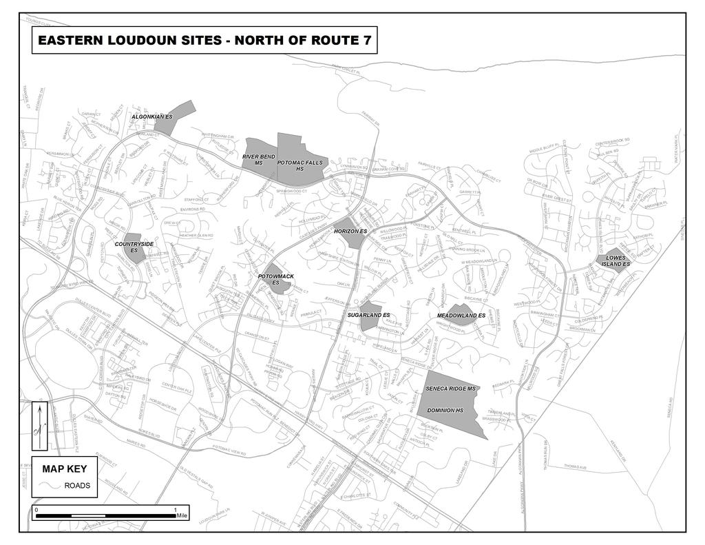
3 CONTENTS Welcome...5 Loudoun County Public Schools Overview Map...6 (Loudoun County Public Schools Building Locations) Facility Listing...7 Central Loudoun...8 (Leesburg and Lucketts) Dulles North (Ashburn)...16 (Ashburn and Lansdowne) Dulles North (South of Dulles Greenway)...22 (Dulles, Broadlands and Brambleton) Dulles South...28 (Aldie, Arcola and South Riding) Eastern Loudoun (North of Route 7)...34 (Potomac Falls and Sugarland Run) Eastern Loudoun (South of Route 7)...35 (Dulles and Sterling) Western Loudoun...40 (Hamilton, Hillsboro, Lovettsville, Middleburg, Purcellville, and Round Hill) Index
4 4
5 Welcome to Loudoun County Public Schools Loudoun County, Virginia is one of the fastest growing counties in the United States. As Loudoun County continues its rapid growth, the Loudoun County Public School system is also growing. In response to numerous requests from staff members, teachers, parents and other Loudoun County residents, the Loudoun County Public Schools Department of Planning and GIS Services has developed this set of maps and directions to Loudoun County Public School facilities and potential future sites. For the purpose of this document, the county has been divided into six geographic areas. Working from west to east, these areas are: Western Loudoun, Central Loudoun, Dulles North Ashburn Area, Dulles North, Dulles South, and Eastern Loudoun. Please use the alphabetical index provided to determine in which area you can find a particular facility. Directions are provided from two locations. Directions from Leesburg are referenced from the Leesburg Courthouse. 1 Directions from Dulles are referenced from the Dulles International Airport. 2 As an added convenience, we have included directions using local toll roads. Many of the school administrative offices are located at the Loudoun County Public School Administration Building (directions on page 24) in Dulles North. For clarity s sake in this guide, highways are identified primarily by their number, not by their name. In our area, Rt. 7 is also referred to as Harry Byrd Highway. Rt. 15 is also referred to as James Monroe Highway. Rt. 50 is also referred to as John Mosby Highway. You will find that some numbered highways have more than one name; for example, Rt. 659 is referred to as Belmont Ridge Road north of Rt. 50, and as Gum Springs Road south of Rt. 50. For this reason, we are citing the numerical designation as our primary identifier. Disclaimer: Every reasonable effort has been made to ensure the accuracy of these data. Loudoun County Public Schools does not assume any liability arising from the use of these data. Users are advised to consult the Department of Planning and Legislative Services to verify all boundary lines. This is especially true for any residence located in a new development, or in a neighborhood near the boundary of a school attendance area. No warranty, either expressed or implied, is offered as to the accuracy or usability of these maps for any purpose. Users assume full responsibility for any application of the information contained in these maps. Users are further advised that school boundary lines are subject to continual review and may be adjusted as conditions warrant. Reliance on these data is at the risk of the user. For information on what schools your children would attend if they lived at a specific address, call the Department of Planning at , or check online at Click on School Attendance Boundaries on the top left hand corner. In case of emergency, information on school closings can be found at the Loudoun County Public School web site, at 1 The Leesburg Courthouse stands at the intersection of Rt. 15 and Rt. 7 in downtown Leesburg, which is in east-central Loudoun County. 2 Dulles Airport is located near the eastern edge of Loudoun County, encircled by Rt. 28, Rt. 50, and the Dulles Greenway. 5
6 6
7 LOUDOUN COUNTY PUBLIC SCHOOLS FACILITY LIST FACILITY NAME PAGE FACILITY NAME PAGE Academies of Loudoun... 9 Administration Building, LCPS...24 Aldie Elementary...29 Algonkian Elementary...36 Arcola Elementary...29 Ashburn Elementary...17 Ball s Bluff Elementary...9 Banneker Elementary...41 Belmont Ridge Middle...17 Belmont Station Elementary...17 Blue Ridge Middle...41 Brambleton Middle Briar Woods High...23 Broad Run High...17 Buffalo Trail Elementary...29 C. S. Monroe Technology Center...10 Cardinal Ridge Elementary...29 Carter (Rosa Lee) Elementary...25 Catoctin Elementary...9 Cedar Lane Elementary...18 Central Fleet Maintenance / Warehouse...9 Champe (John) High Cool Spring Elementary...10 Countryside Elementary...36 Creighton s Corner Elementary...23 Culbert (Kenneth W.) Elementary...43 Discovery Elementary Dominion High...36 Dominion Trail Elementary...18 Douglass School...10 Douglass (Frederick) Elementary...11 Eagle Ridge Middle...23 Emerick Elementary...41 Evergreen Mill Elementary...10 Farmwell Station Middle...18 Forest Grove Elementary...36 Frances Hazel Reid Elementary...11 Frederick Douglass Elementary 11 Freedom High...30 Goshen Post Elementary..30 Guilford Elementary...36 Hamilton Elementary...42 Harmony Middle...42 Harper Park Middle...11 Heritage High...11 Hillsboro Charter Academy...42 Hillside Elementary...24 Horizon Elementary...37 Hutchison Farm Elementary...30 Independence High...24 J. Lupton Simpson Middle...12 J. Michael Lunsford Middle...31 John Champe High John W. Tolbert, Jr. Elementary...12 Kenneth W. Culbert Elementary...43 LCPS Administration Building...24 Leesburg Elementary...12 Legacy Elementary...25 Liberty Elementary...31 Lightridge High..32 Lincoln Elementary Little River Elementary...32 Loudoun County High...12 Loudoun Valley High...43 Lovettsville Elementary...44 Lowes Island Elementary...37 Lucketts Elementary...13 Lunsford (J. Michael) Middle...31 Madison s Trust Elementary..25 Map, Central Loudoun...8 Map, Dulles North (Ashburn)...16 Map, Dulles North (south of Greenway)...22 Map, Dulles South...28 Map, Eastern Loudoun (north of Rt. 7)...34 Map, Eastern Loudoun (south of Rt. 7) Map, Overview...6 Map, Western Loudoun...40 Meadowland Elementary...37 Mercer Middle...32 Middleburg Community Charter...44 Mill Run Elementary...25 Moorefield Station Elementary Monroe (C. S.) Technology Center...10 Mountain View Elementary...44 Newton-Lee Elementary...19 Park View High...37 Pinebrook Elementary...32 Potomac Falls High...37 Potowmack Elementary...38 Reid (Frances Hazel) Elementary...11 River Bend Middle...38 Riverside High Rock Ridge High Rolling Ridge Elementary...38 Rosa Lee Carter Elementary...26 Round Hill Elementary...45 Round Hill Support Facility...45 Sanders Corner Elementary...19 Seldens Landing Elementary...19 Seneca Ridge Middle...38 Simpson (J. Lupton) Middle...12 Smart s Mill Middle...13 Staff Training Center...20 Sterling Elementary...38 Sterling Middle...39 Steuart W. Weller Elementary...20 Stone Bridge High...20 Stone Hill Middle...26 Sugarland Elementary...39 Sully Elementary...39 Sycolin Creek Elementary...13 Tolbert, Jr. (John W.) Elementary...12 Trailside Middle...20 Transportation Building...13 Tuscarora High...14 Unnamed ES Unnamed ES Union Street Facility 14 Valley Service Center...45 Waterford Elementary...46 Weller (Steuart W.) Elementary...20 Willard Middle...33 Woodgrove High...46
8 8
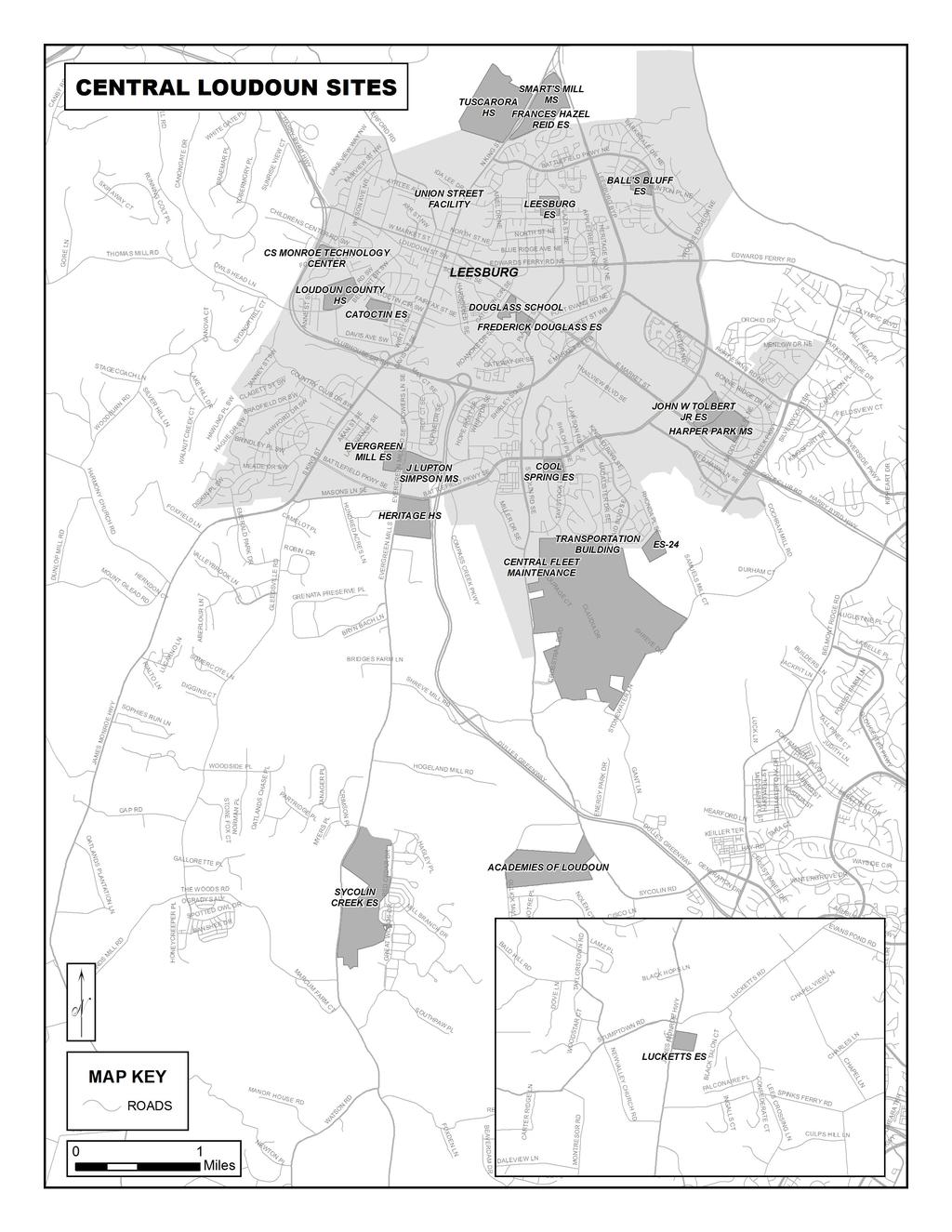
9 CENTRAL LOUDOUN ACADEMIES OF LOUDOUN Loudoun Academy Drive, Leesburg, VA Travel east on Rt. 7 Bus [E. Market Street]. Turn RIGHT (S) on Plaza Street, which becomes Sycolin Road SE. Continue on Sycolin Road to Loudoun Academy Drive on the right. School building and parking lot will be straight ahead. Travel north on Dulles Airport Access Road and merge onto Rt. 28 (N) [Sully Road]. Merge onto Rt. 7 (W) towards Leesburg. Continue on Rt. 7 (W) to traffic signal at Belmont Ridge Road. Turn LEFT onto Belmont Ridge Road. Follow to Sycolin Rd. Turn RIGHT on Sycolin Road. Continue on Sycolin Road to Loudoun Academy Drive on the LEFT. Turn left and follow straight ahead to parking lot. Travel north on Dulles Airport Access Road and merge onto Rt. 267 (W) [Dulles Greenway]. At Rt. 267 Exit 2 Battlefield Parkway, turn off onto ramp. Follow to traffic light at Battlefield Parkway. Continue straight at traffic light onto Miller Drive. Follow to end at Sycolin Road. Turn RIGHT onto Sycolin Road. Continue on Sycolin Road to Loudoun Academy Drive on the right. School building and parking lot will be straight ahead. BALL S BLUFF ELEMENTARY 821 Battlefield Parkway, NE, Leesburg, VA Tel: (571) Travel north on N. King Street [Rt. 15 Bus N]. Turn RIGHT (SE) onto Battlefield Parkway. Cross Rt. 15 Bypass and continue on Battlefield Parkway. School is on the right. Travel north on Dulles Airport Access Road and merge onto Rt. 28 (N) [Sully Road]. Merge onto Rt. 7 (W) towards Leesburg. Continue through intersections, following signs for Rt. 15N Continue through intersection with Edwards Ferry Road. At next light, turn RIGHT (E) onto Battlefield Parkway. School is on the right. Travel north on Dulles Airport Access Road and merge onto Rt. 267 (W) [Dulles Greenway] to Leesburg. At Exit 1-B, merge onto Rt. 15 Byp (N)/Rt. 7. Stay to the left past the shopping areas. Turn RIGHT (E) onto Battlefield Parkway. School is on the right. CATOCTIN ELEMENTARY 311 Catoctin Circle, SW, Leesburg, VA Tel: (571) Travel south on Rt. 15 Bus [S. King Street]. Turn RIGHT (W) onto Catoctin Circle SW. The school is on the left. Travel north on Dulles Airport Access Road and merge onto Rt. 28 (N) [Sully Road]. Merge onto Rt. 7 (W) towards Leesburg. Exit 7 Business, which becomes East Market Street. Turn LEFT onto Catoctin Circle SW. The school is on the left, several blocks after crossing King Street. Travel north on Dulles Airport Access Road and merge onto Rt. 267 (W) [Dulles Greenway]. Take Rt. 267 Exit 1A, and stay to the right after merging onto Rt. 15 Byp [Rt. 7W]. Exit onto Rt.15 Bus [S. King Street] (turn RIGHT). Continue on Rt. 15 Bus [S. King Street]. Turn LEFT (W) onto Catoctin Circle SW. School is on the left. CENTRAL FLEET MAINTENANCE / WAREHOUSE 1002-C Sycolin Road SE, Leesburg, VA WAREHOUSE: 1002-A Sycolin Road, Leesburg, VA Tel: (571) Travel east on Rt. 7 Bus [E. Market Street]. Turn RIGHT (S) on Plaza Street, which becomes Sycolin Road SE. Facilities are co-located with the County of Loudoun Central Warehouse. Turn left to enter parking lot, then drive through gate to building on left. Travel north on Dulles Airport Access Road and merge onto Rt. 28 (N) [Sully Road]. Merge onto Rt. 7 (W) towards Leesburg. Continue on Rt. 7 (W) to traffic signal at Battlefield Pkwy. Turn LEFT onto Battlefield Pkwy. Follow to Sycolin Rd. Turn LEFT (S) on Sycolin Road SE. Facilities are colocated with the County of Loudoun Central Warehouse. Turn left to enter parking lot, then drive through gate to building on the left. Travel north on Dulles Airport Access Road and merge onto Rt. 267 (W) [Dulles Greenway]. At Rt. 267 Exit 2, turn off onto ramp to Miller Drive SE. Follow Miller Drive and turn RIGHT (S) onto Sycolin Creek Road SE. Facilities are co-located with the County of Loudoun Central Warehouse. Turn left to enter parking lot, then drive through gate to building on the left. 9
10 CENTRAL LOUDOUN COOL SPRING ELEMENTARY 501 Tavistock Drive SE, Leesburg, VA Tel: (571) Travel east on Rt. 7 Bus [E. Market Street]. Turn RIGHT (S) on Plaza Street, which becomes Sycolin Road SE. Turn LEFT at the traffic light onto Battlefield Pkwy SE. School is visible on your right. Turn RIGHT (S) onto Tavistock Drive SE to enter school grounds. Travel north on Dulles Airport Access Road and merge onto Rt. 28 (N) [Sully Road]. Merge onto Rt. 7 (W) towards Lees burg. Turn LEFT at the traffic light onto Battlefield Pkwy SE. School is visible on your LEFT. Turn LEFT (S) onto Tavistock Drive SE to enter school grounds. Travel north on Dulles Airport Access Road and merge onto Rt. 267 (W) [Dulles Greenway]. Follow Rt. 267 (W) to Exit 2. Follow ramp to traffic light at Battlefield Pkwy. Turn LEFT onto Battlefield Pkwy SE. School is visible on your right. Turn RIGHT (S) onto Tavistock Drive SE to enter school grounds. C. S. MONROE TECHNOLOGY CENTER 715 Childrens Center Road SW, Leesburg, VA Tel: (571) Travel west on Rt. 7 Bus [Market St.] and turn LEFT (S) onto Catoctin Circle SW. Turn RIGHT (W) onto Children s Center Road. School is on the immediate left. Travel north on Dulles Airport Access Road and merge onto Rt. 28 (N) [Sully Road]. Merge onto Rt. 7 (W) towards Leesburg. Continue west on Rt 7 Bus [Market St.] and turn LEFT (S) onto Catoctin Circle SW. Turn RIGHT (W) onto Children s Center Road. School is on the immediate left. Travel north on Dulles Airport Access Road and merge onto Rt. 267 (W) [Dulles Greenway]. Take Rt. 267 Exit 1A, and stay to the right after merging onto Rt. 15 Byp [Rt. 7W]. Take exit for Rt. 7 Bus (E) [W. Market St.]. Turn RIGHT (S) onto Catoctin Circle SW. Turn RIGHT (W) onto Children s Center Road. School is on the immediate left. DOUGLASS SCHOOL 407 East Market Street, Leesburg, VA Tel: (571) Travel east on Rt. 7 Bus [E. Market Street]. School is on the right. Travel north on Dulles Airport Access Road and merge onto Rt. 28 (N) [Sully Road]. Merge onto Rt. 7 (W) towards Leesburg. Continue on Rt. 7 Bus [E. Market Street]. School will be on the left. Travel north on Dulles Airport Access Road and merge onto Rt. 267 (W) [Dulles Greenway]. Take Rt. 267 Exit 1B. Turn LEFT (N) on Sycolin Road, which becomes Plaza Street. Turn LEFT (NW) onto Market Street. School is on the left. EVERGREEN MILL ELEMENTARY 491 Evergreen Mill Road, SE, Leesburg, VA Tel: (571) Travel south on Rt. 15 Bus [S. King St.]. Turn LEFT (SE) onto Evergreen Mill Road SE. School is on the right. Travel north on Dulles Airport Access Road and merge onto Rt. 28 (N) [Sully Road]. Merge onto Rt. 7 (W) towards Leesburg. Continue on Rt. 7 (W) to traffic signal at Battlefield Pkwy. Turn LEFT onto Battlefield Pkwy. Follow to Evergreen Mill Rd. Turn RIGHT (N) on Evergreen Mill Road. School is on the left. Travel north on Dulles Airport Access Road and merge onto Rt. 267 (W) [Dulles Greenway]. Follow Rt. 267 (W) to Exit 2. Follow ramp to traffic light at Battlefield Pkwy. Turn RIGHT onto Battlefield Pkwy. At second traffic signal, turn RIGHT onto Evergreen Mill Road SE. School is on the left. 10
11 CENTRAL LOUDOUN FRANCES HAZEL REID ELEMENTARY 800 North King Street, Leesburg, VA Tel: (571) Travel north on N. King Street [Rt. 15 Bus] Continue through traffic signal at Battlefield Parkway and turn RIGHT at second signal (after Dry Hollow Road). Frances Hazel Reid is to the right of Smart s Mill Middle School. Travel north on Dulles Airport Access Road and merge onto Rt. 28 (N) [Sully Road]. Merge onto Rt. 7 (W) and follow toward Leesburg. Remain on Rt 7 Bus [E. Market Street] into Leesburg. Turn right on N. King Street. Continue straight to second light after Battlefield Parkway. Turn right into schools entrance. The elementary school is on the right. Smart s Mill Middle school is on the left. Travel north on Dulles Airport Access Road and merge onto Rt. 267 (W) [Dulles Greenway]. Take Rt. 267 Exit 1A, and stay to the right after merging onto Rt. 15 Byp [Rt. 7W]. Take Leesburg exit onto Rt.15 Bus (N) [S. King St.]. Continue on Rt. 15 Bus [N. King St.] as if you are heading out of town. Continue through traffic signal at Battlefield Parkway and turn RIGHT at second signal (after Dry Hollow Road). School is on the right. FREDERICK DOUGLASS ELEMENTARY 510 Principal Drummond Way, Leesburg, VA Tel: (571) Travel east on Rt. 7 Bus [E. Market Street]. Turn RIGHT (S) on Plaza Street. Turn RIGHT onto Principal Drummond Way. The school is on the right, before the bridge. Travel north on Dulles Airport Access Road and merge onto Rt. 28 (N) [Sully Road]. Merge onto Rt. 7 (W) towards Leesburg. Continue on Rt. 7 Bus [E. Market Street]. Turn LEFT (S) on Plaza Street. Turn RIGHT onto Principal Drummond Way. The school is on the right, before the bridge. Travel north on Dulles Airport Access Road and merge onto Rt. 267 (W) [Dulles Greenway]. At Rt. 267 Exit 1B, merge onto Rt. 15 [Rt. 7]. Turn LEFT (N) on Sycolin Road, which becomes Plaza Street. Turn LEFT onto Principal Drummond Way. The school is on the left, after the bridge. HARPER PARK MIDDLE 701 Potomac Station Drive NE, Leesburg, VA Tel: (571) Travel east on Rt. 7 Bus [E. Market St.]. and continue on 7E towards Sterling. Turn LEFT (N) on Battlefield Parkway. Turn RIGHT (NE) onto Potomac Station Drive. Harper Park is the second school on the right. Travel north on Dulles Airport Access Road and merge onto Rt. 28 (N) [Sully Road]. Merge onto Rt. 7 (W) towards Leesburg. Follow ramp onto River Creek Parkway (N). Turn LEFT (W) onto Potomac Station Drive. Harper Park is the first school on the left. Travel north on Dulles Airport Access Road and merge onto Rt. 267 (W) [Dulles Greenway]. Follow Rt. 267 (W) to Exit 2. Follow ramp to traffic light at Battlefield Pkwy. Turn LEFT on Battlefield Pkwy SE. Turn RIGHT on Potomac Station Drive NE. Harper Park is the second school on right. HERITAGE HIGH 520 Evergreen Mill Road SE, Leesburg, VA Tel: (571) Travel south on Rt. 15 Bus [S. King Street]. Turn LEFT (SE) onto Evergreen Mill Road SE. Heritage is the second school on the left, just beyond the Freedom Park athletic fields. Travel north on Dulles Airport Access Road and merge onto Rt. 28 (N) [Sully Road]. Merge onto Rt. 7 (W) towards Leesburg. Continue on Rt. 7W to Battlefield Pkwy. Turn LEFT (S) onto Battlefield Pkwy. Continue on Battlefield Parkway to Evergreen Mill Rd. Turn LEFT (S) on Evergreen Mill Rd. School is on the left. Travel north on Dulles Airport Access Road and merge onto Rt. 267 (W) [Dulles Greenway]. Follow Rt. 267 (W) to Exit 2. Follow ramp to traffic light at Battlefield Pkwy. Turn RIGHT onto Battlefield Pkwy. Continue on Battlefield Parkway to Evergreen Mill Rd. Turn LEFT (S) on Evergreen Mill Rd. School is on the left. 11
12 CENTRAL LOUDOUN J. LUPTON SIMPSON MIDDLE 490 Evergreen Mill Road SE, Leesburg, VA Tel: (571) Travel south on Rt. 15 Bus [S. King St.]. Turn LEFT (SE) onto Evergreen Mill Road SE. School is the first school on the left, across from Evergreen Mill ES. Travel north on Dulles Airport Access Road and merge onto Rt. 28 (N) [Sully Road]. Merge onto Rt. 7 (W) towards Leesburg. Continue on Rt. 7 (W) to traffic signal at Battlefield Pkwy. Turn LEFT onto Battlefield Pkwy. Follow to Evergreen Mill Rd. Turn RIGHT (N) on Evergreen Mill Road. School is on the RIGHT. Travel north on Dulles Airport Access Road and merge onto Rt. 267 (W) [Dulles Greenway]. Follow Rt. 267 (W) to Exit 2. Follow ramp to traffic light at Battlefield Pkwy. Turn RIGHT onto Battlefield Pkwy. At second traffic signal, turn RIGHT onto Evergreen Mill Road SE. School is on the RIGHT. JOHN W. TOLBERT, JR. ELEMENTARY 691 Potomac Station Drive NE, Leesburg, VA Tel: (571) Travel east on Rt. 7 Bus [E. Market St.]. and continue on 7E towards Sterling. Turn LEFT (N) on Battlefield Parkway. Turn RIGHT (NE) onto Potomac Station Drive. Tolbert is the first school on the right. Travel north on Dulles Airport Access Road and merge onto Rt. 28 (N) [Sully Road]. Merge onto Rt. 7 (W) towards Lees burg. Follow ramp to the right onto River Creek Parkway (N). Turn LEFT (W) onto Potomac Station Drive. John W. Tolbert Jr Elementary is the second school on the left, past Harper Park Middle. Travel north on Dulles Airport Access Road and merge onto Rt. 267 (W) [Dulles Greenway]. Follow Rt. 267 (W) to Exit 2. Follow ramp to traffic light at Battlefield Pkwy. Turn LEFT onto Battlefield Pkwy SE. Turn RIGHT (S) onto Potomac Station Drive NE. John W Tolbert Jr. Elementary is the first school on the right. LEESBURG ELEMENTARY 323 Plaza Street NE, Leesburg, VA Tel: (571) Travel east on Market Street. Turn LEFT (NE) on Plaza Street. School is on the left; turn LEFT to enter parking lots. Travel north on Dulles Airport Access Road and merge onto Rt. 28 (N) [Sully Road]. Merge onto Rt. 7 (W) towards Leesburg. Continue on Rt. 7 Bus. [East Market Street]. Turn RIGHT (N) onto Plaza Street. School is on the left. Travel north on Dulles Airport Access Road and merge onto Rt. 267 (W) [Dulles Greenway]. At Rt. 267 Exit 1B, turn off onto ramp and continue east on Rt. 15/Rt. 7 Bypass. Turn LEFT (N) onto Sycolin Road, which will become Plaza Street NE. School is on the left. LOUDOUN COUNTY HIGH 415 Dry Mill Road SW, Leesburg, VA Tel: (571) Travel south on Rt. 15 Bus [S. King St.]. Turn RIGHT (W) onto Loudoun Street. Turn LEFT (S) onto Dry Mill Road. School is on the right, at intersection of Catoctin Circle SW and Dry Mill Road. Travel north on Dulles Airport Access Road and merge onto Rt. 28 (N) [Sully Road]. Merge onto Rt. 7 (W) towards Leesburg. Continue on Rt. 7 Bus.[East Market Street]. Turn LEFT (S) on Cactoctin Circle. School is just after the intersec tion with Dry Mill Road, on the left. Travel north on Dulles Airport Access Road and merge onto Rt. 267 (W) [Dulles Greenway]. Take Rt. 267 Exit 1A, and merge onto Rt. 15 Byp [Rt. 7W]. Exit onto Rt.15 Bus (N) toward Leesburg [S. King St.] At second traffic signal, turn LEFT (W) onto Catoctin Circle SW. School is on the corner of Catoctin Circle and Dry Mill Road. 12
13 CENTRAL LOUDOUN LUCKETTS ELEMENTARY James Monroe Highway, Leesburg, VA Tel: (571) Travel north on Rt. 15 Bus (N) [N. King St.]. Merge with Rt. 15 (N) to Lucketts (about 5.5 miles). School is on the right. Travel north on Dulles Airport Access Road and merge onto Rt. 28 (N) [Sully Road]. Merge onto Rt. 7W. Follow sign for Rt. 15N Bypass, toward Frederick, MD. Merge onto Rt. 15 (N); continue for 5-6 miles. School is on the right. Travel north on Dulles Airport Access Road and merge onto Rt. 267 (W) [Dulles Greenway]. At Rt. 267 Exit 1B, turn off onto ramp, and continue north on Rt 15 Bypass [Rt.7]. Merge onto Rt. 15 (N); continue for 5-6 miles. School is on the right. SMART S MILL MIDDLE 850 North King Street, Leesburg, VA Tel: (571) Travel north on N. King Street [Rt. 15 Bus] as if you are heading out of town. Continue through traffic signal at Battlefield Parkway and turn RIGHT at next signal (after Dry Hollow Road). School is on the left. Travel north on Dulles Airport Access Road and merge onto Rt. 28(N). Exit Rt. 7W and continue to Leesburg. Remain on Rt. 7 Bus [E. Market Street]. Turn RIGHT (N) on N. King Street. Turn RIGHT at second light after Battlefield Parkway. School is on the left. Travel north on Dulles Airport Access Road and merge onto Rt. 267 (W) [Dulles Greenway]. Take Rt. 267 Exit 1A, staying to the right after merging onto Rt. 15 Byp [Rt. 7W]. Take the Leesburg exit onto Rt.15 Bus [S. King St.] (turn RIGHT). Continue on Rt. 15 Bus [N. King St.] as if you are heading out of town. Continue through traffic signal at Battlefield Parkway Turn RIGHT at second signal (after Dry Hollow Road). School is on the left. SYCOLIN CREEK ELEMENTARY Evergreen Mills Road, Leesburg, VA Tel: (571) Travel south on Rt. 15 Bus [S. King St.]. Turn LEFT (SE) onto Evergreen Mill Road SE. Continue on Evergreen Mill Rd. past J. Lupton Simpson MS/ Evergreen Mill ES and Heritage HS approximately 3-4 miles. School is on the left. Travel north on Dulles Airport Access Road and merge onto Rt. 28 (N) [Sully Road]. Merge onto Rt. 7 (W) towards Leesburg. Continue on Rt. 7W to Battlefield Pkwy. Turn LEFT (S) onto Battlefield Pkwy. Continue on Battlefield Parkway to Evergreen Mill Rd. Turn LEFT (SE) onto Evergreen Mill Road SE. Continue on Evergreen Mill Rd. past Heritage HS approximately 3-4 miles. School is on the left. Travel north on Dulles Airport Access Road and merge onto Rt. 267 (W) [Dulles Greenway]. Follow Rt. 267 (W) to Exit 2. Follow ramp to traffic light at Battlefield Pkwy. Turn RIGHT onto Battlefield Pkwy. Continue on Battlefield Parkway to Evergreen Mill Rd. Turn LEFT (S) on Evergreen Mill Rd. Continue on Evergreen Mill Rd. past Heritage HS approximately 3-4 miles. School is on the left. TRANSPORTATION BUILDING Loudoun Center Place Leesburg, VA Tel: (571) Travel east on Rt. 7 Bus [E. Market Street]. Turn RIGHT (S) on Plaza Street, which becomes Sycolin Road SE. Turn LEFT (E) on Loudoun Center Place. This facility is co-located with Loudoun County Vehicle Maintenance. It is downhill from the four-way stop on Loudoun Center Place. Travel north on Dulles Airport Access Road and merge onto Rt. 28 (N) [Sully Road]. Merge onto Rt. 7 (W) towards Leesburg. Continue on Rt. 7 (W) to traffic signal at Battlefield Pkwy. Turn LEFT onto Battlefield Pkwy. Turn LEFT (S) on onto Sycolin Road SE. Turn LEFT (E) on Loudoun Center Place. Travel north on Dulles Airport Access Road and merge onto Rt. 267 (W) [Dulles Greenway]. At Rt. 267 take Exit 2, turn off At the end of the ramp, continue to Battlefield Pkwy. Turn LEFT onto Battlefield Pkwy. Turn RIGHT (S) onto Sycolin Road SE. Turn LEFT (E) on Loudoun Center Place. This facility is co-located with Loudoun County Vehicle Maintenance. It is downhill from the four-way stop on Loudoun Center Place. 13
14 CENTRAL LOUDOUN TUSCARORA HIGH 801 North King Street, Leesburg, VA Tel: (571) Travel north on N. King Street [Rt. 15 Bus]. Continue past the traffic signal at Battlefield Parkway. The school entrance is at the next traffic light on the LEFT. Travel north on Dulles Airport Access Road and merge onto Rt. 28(N). Exit Rt. 7W and continue to Leesburg. Remain on Rt. 7 Bus [E. Market Street]. Turn RIGHT (N) on N. King Street. Continue through traffic signal at Battlefield Parkway. School entrance is on the left at the next traffic signal. Travel north on Dulles Airport Access Road and merge onto Rt. 267 (W) [Dulles Greenway]. Take Rt. 267 Exit 1A, and stay to the right after merging onto Rt. 15 Byp [Rt. 7W]. Exit onto Rt.15 Bus [S. King St.] toward Leesburg. Turn RIGHT at the end of the ramp. Travel north on Rt. 15 Bus [N. King St.] through town. Continue through traffic signal at Battlefield Parkway. School entrance is on the left at the next traffic signal. UNION STREET FACILITY 20 Union Street, Leesburg, VA Tel: (571) Travel north on N. King Street [Rt. 15 Bus]. Turn LEFT onto Union Street. The facility is on the right. Travel north on Dulles Airport Access Road and merge onto Rt. 28(N). Exit Rt. 7W and continue to Leesburg. Remain on Rt. 7 Bus [E. Market Street]. Turn RIGHT (N) on N. King Street. Turn LEFT onto Union Street. The facility is on the right. Travel north on Dulles Airport Access Road and merge onto Rt. 267 (W) [Dulles Greenway]. Take Rt. 267 Exit 1A, and stay to the right after merging onto Rt. 15 Byp [Rt. 7W]. Exit onto Rt.15 Bus [S. King St.] toward Leesburg. Turn RIGHT at the end of the ramp. Travel north on Rt. 15 Bus [N. King St.] through town. Turn LEFT onto Union Street. The facility is on the right. 14
15 Page is intentionally blank. 15
16 16
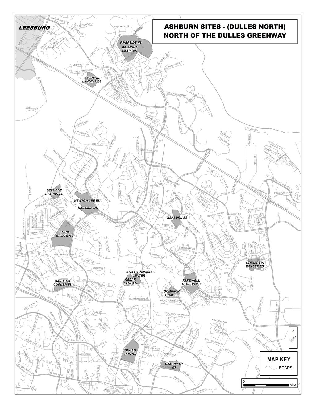
17 ASHBURN (DULLES NORTH) ASHBURN ELEMENTARY Fincastle Drive, Ashburn, VA Tel: (571) Travel east on Rt. 7 Bus [E. Market St.], and continue on Rt. 7E towards Sterling. Exit RIGHT (S) onto Ashburn Village Blvd. School is on the right. Turn RIGHT (SW) onto Fincastle Drive to enter school grounds. Travel north on Dulles Airport Access Road and merge onto Rt. 28 (N) [Sully Road]. Exit LEFT (W) at Rt. VA-625 [Waxpool Road], which becomes Rt. 640 [Farmwell Road]. Continue NW, and turn RIGHT (N) onto Ashburn Village Blvd. School is on the left. Turn LEFT (SW) onto Fincastle Drive to enter school grounds. Travel north on Dulles Airport Access Road and merge onto Rt. 267 (W) [Dulles Greenway]. Take Exit 6 off of Rt. 267 to Ashburn Village Blvd. (N). School is the second school on the left. Turn LEFT (N) onto Fincastle Drive to enter school grounds. BELMONT RIDGE MIDDLE Upper Belmont Place, Leesburg, VA Tel: (571) Travel east on Rt. 7 Bus [E. Market St.]. Turn LEFT(N) onto Rt. 659 [Belmont Ridge Road] which becomes Upper Belmont Place. School is on the left. Travel north on Dulles Airport Access Road. Take Rt. 28 (N) [Sully Road]. Merge onto Rt. 7 (W) towards Leesburg. Travel west on Rt. 7. Turn RIGHT (N) onto Rt. 659 [Belmont Ridge Road] which becomes Upper Belmont Place. School is on the left. Travel north on Dulles Airport Access Road and merge onto Rt. 267 (W) [Dulles Greenway]. Take exit 4 [Belmont Ridge Road] and travel north. Beyond Rt. 7, Belmont Ridge Road becomes Upper Belmont Place. School is on the left. BELMONT STATION ELEMENTARY Nightwatch Street, Ashburn, Virginia Tel: (571) Travel east on Rt. 7 Bus [E. Market St.]. Turn RIGHT (S) onto Rt. 659 [Belmont Ridge Road]. Turn LEFT on Portsmouth Road. Turn LEFT on Nightwatch Street. School is on the left. Travel north on Dulles Airport Access Road. Take Rt. 28 (N) [Sully Road]. Exit LEFT (W) at Rt. VA-625 [Waxpool Road], which becomes Rt. 640 [Farmwell Road] and Ashburn Farm Pkwy. Turn RIGHT (S) onto Rt. 659 [Belmont Ridge Road]. Turn RIGHT on Portsmouth Road. Turn LEFT on Nightwatch Street. School is on the left. Travel north on Dulles Airport Access Road and merge onto Rt. 267 (W) [Dulles Greenway]. Take exit 4 [Belmont Ridge Road] and travel north. Turn RIGHT on Portsmouth Road. Turn LEFT on Nightwatch Street. School is on the left. BROAD RUN HIGH Ashburn Road, Ashburn, VA Tel: (571) Travel east on Rt. 7 Bus [E. Market St.] and continue on Rt. 7E towards Sterling for about 5.5 miles. Exit RIGHT (S) onto Claiborne Pkwy (S). Turn LEFT onto Russell Branch Pkwy. Turn RIGHT onto Ashburn Rd. School is on left, after the traffic signal at the Ashburn Farm Parkway intersection. Travel north on Dulles Airport Access Road and merge onto Rt. 28 (N) [Sully Road]. Exit LEFT onto Rt. VA-625 W [Waxpool Road], which becomes Farmwell Road. Turn LEFT (S) onto Rt. 641 [Ashburn Rd]. School is on the left. Travel north on Dulles Airport Access Road and merge onto Rt. 267 (W) [Dulles Greenway]. Take Exit 6 (Rt 772). Turn RIGHT onto Rt. 772 (N) [Ryan Rd]. Turn LEFT (NW) onto Shellhorn Rd. Turn LEFT (W) onto Rt. VA-625 [Waxpool Road], and turn RIGHT (N) onto Rt. 641 [Ashburn Rd]. School is on the right. 17
18 ASHBURN (DULLES NORTH) CEDAR LANE ELEMENTARY Tolamac Drive, Ashburn, VA Tel: (571) Travel east on Rt. 7 Bus [E. Market St.], and continue on Rt. 7E towards Sterling. Exit RIGHT onto Claiborne Pkwy/Belmont (S). Turn LEFT (E) onto Russell Branch Pkwy. Turn RIGHT (S) onto Ashburn Rd. Turn RIGHT (W) onto Tolamac Drive. School is at the end of the road. Travel north on Dulles Airport Access Road and merge onto Rt. 28 (N) [Sully Road]. Exit LEFT at Rt. VA-625 W [Waxpool Road], which becomes Rt. 640 [Farmwell Road]. Turn RIGHT (N) onto Ashburn Road for approximately 1/2 mile. Turn LEFT (W) onto Tolamac Drive. The school is at the end of the road. Travel north on Dulles Airport Access Road and merge onto Rt. 267 (W) [Dulles Greenway]. Take Exit 6 (Rt 772). Turn RIGHT (N) at end of ramp. Turn LEFT (W) onto Farmwell Road. Turn RIGHT (N) onto Ashburn Road. Turn LEFT (W) onto Tolamac Drive. The school is at the end of the road. DISCOVERY ELEMENTARY Grace Bridge Drive, Ashburn, VA Tel: (571) Travel east on Rt. 7 Bus [E. Market St.] and continue on Rt. 7E towards Sterling. Exit RIGHT (S) onto Ashburn Village Blvd. Turn LEFT (E) onto Grace Bridge Drive. School entrance is on left. Travel north on Dulles Airport Access Road and merge onto Rt. 28 (N) [Sully Road]. Exit LEFT (W) at Rt. VA-625 [Waxpool Road], which becomes Rt. 640 [Farmwell Road]. Continue NW and turn LEFT (S) onto Ashburn Village Blvd. Turn LEFT (E) onto Grace Bridge Drive. School entrance is on the left.. Travel north on Dulles Airport Access Road and merge onto Rt. 267 (W) [Dulles Greenway]. Take Exit 6 Rt Turn RIGHT (N) at end of ramp. Turn RIGHT (E) onto Grace Bridge Drive. School entrance is on the left. DOMINION TRAIL ELEMENTARY Bruceton Mills Circle, Ashburn, VA Tel: (571) Travel east on Rt. 7 Bus [E. Market St.], and continue on Rt. 7E towards Sterling. Exit RIGHT (S) onto Ashburn Village Blvd. Turn RIGHT (W) onto Bruceton Mills Circle. School is on the left. Travel north on Dulles Airport Access Road and merge onto Rt. 28 (N) [Sully Road]. Exit LEFT (W) at Rt. VA-625 [Waxpool Road], which becomes Rt. 640 [Farmwell Road]. Continue NW, and turn RIGHT (N) onto Ashburn Village Blvd. School is on the left. Turn LEFT (W) onto Bruceton Mills Circle to enter grounds. Travel north on Dulles Airport Access Road and merge onto Rt. 267 (W) [Dulles Greenway]. Take Exit 6 (Rt. 772). Turn RIGHT (N) at end of ramp. Continue north on Ashburn Village Blvd. School is on the left. Turn LEFT (W) onto Bruceton Mills Circle to enter grounds. FARMWELL STATION MIDDLE Gloucester Parkway, Ashburn, VA Tel: (571) Travel east on East Market Street and continue on Rt. 7E towards Sterling. Exit RIGHT (S) onto Ashburn Village Blvd. Turn LEFT (SE) onto Gloucester Parkway. School is on the right, after crossing Ashburn Village Boulevard. Travel north on Dulles Airport Access Road and merge onto Rt. 28 (N)[Sully Road]. Exit LEFT onto VA-625 W [Waxpool Road]. Continue west for about 3.5 miles (name changes to Farmwell Road). Turn RIGHT (N) on Ashburn Village Blvd. Turn RIGHT (SE) onto Gloucester Parkway. School is on the right. Travel north on Dulles Airport Access Road and merge onto the Dulles Greenway W (Rt. 267). At Rt. 267 Exit 6, turn off onto ramp. Turn RIGHT onto Rt. 772 (N) [Ryan Road]. Continue on Ashburn Village Blvd. Turn RIGHT (SE) onto Gloucester Parkway. School is on the right. 18
19 ASHBURN (DULLES NORTH) NEWTON-LEE ELEMENTARY Gloucester Parkway, Ashburn, VA Tel: (571) Travel east on Rt. 7 Bus [E. Market St.] and continue on Rt. 7E towards Sterling. Turn RIGHT (S) onto Belmont Ridge Road [Rt. 659]. Turn LEFT (E) onto Gloucester Parkway. School is on the right. Travel north on Dulles Airport Access Road and merge onto Rt. 28 (N) [Sully Road]. Exit LEFT onto VA-625 W [Waxpool Road]. Continue west (name changes to Farmwell Road, then to Ashburn Farm Parkway). Turn RIGHT (N) on Rt. 641 [Ashburn Road]. Turn LEFT (E) on Gloucester Parkway. School is on the right. Travel north on the Dulles Airport Access Road and merge onto Rt. 267 (W) [Dulles Greenway]. Take Rt. 267 Exit 4 and turn RIGHT (N) onto Belmont Ridge Road. Turn RIGHT(E) onto Gloucester Parkway. School is on the right. RIVERSIDE HIGH Upper Belmont Place, Leesburg, VA Tel: (703) PLEASE NOTE -telephone number to be used temporarily until Fall 2015 Travel east on Rt. 7 Bus [E. Market St.]. Turn LEFT (N) onto Rt. 659 [Belmont Ridge Road] which becomes Upper Belmont Place. Continue past Belmont Ridge Middle School. Riverside High School is on the left. Travel north on Dulles Airport Access Road. Take Rt. 28 (N) [Sully Road]. Merge onto Rt. 7 (W) towards Leesburg. Travel west on Rt. 7. Turn RIGHT (N) onto Rt. 659 [Belmont Ridge Road] which becomes Upper Belmont Place. Continue past Belmont Ridge Middle School. Riverside High School is on the left. Travel north on Dulles Airport Access Road and merge onto Rt. 267 (W) [Dulles Greenway]. Take exit 4 [Belmont Ridge Road] and travel north. After crossing Rt. 7, Belmont Ridge Road becomes Upper Belmont Place. Continue past Belmont Ridge Middle School. Riverside High School is on the left. SANDERS CORNER ELEMENTARY Ashburn Farm Parkway, Ashburn, VA Tel: (571) Travel east on Rt. 7 Bus [E. Market St.] and continue on Rt. 7E towards Sterling. Turn RIGHT (S) onto Belmont Ridge Road [Rt. 659]. Turn LEFT (E) onto Ashburn Farm Parkway. School is on the left. Travel north on Dulles Airport Access Road and merge onto Rt. 28 (N) [Sully Road]. Exit LEFT to VA-625 W [Waxpool Road]. Continue west (name changes to Farmwell Road, then to Ashburn Farm Parkway). School is on the right, a few miles beyond Claiborne Parkway. Travel north on the Dulles Airport Access Road and merge onto Rt. 267 (W) [Dulles Greenway]. Take Rt. 267 Exit 5 and turn RIGHT (N) onto Claiborne Parkway. Turn LEFT (W) onto Ashburn Farm Parkway. School is on the right. SELDENS LANDING ELEMENTARY Coton Commons Drive, Leesburg, VA Tel: (571) Travel east on Rt. 7 for about 3 miles. Turn LEFT (N) onto Belmont Ridge Road, which becomes Upper Belmont Place. Turn LEFT onto Riverside Parkway. Turn LEFT onto Coton Manor Drive (sign to right says Kipheart Road). Turn RIGHT onto Coton Commons Drive. School is on the left. Travel north on Dulles Airport Access Road. Take Rt. 28 (N) [Sully Road]. Merge onto Rt. 7 (W) towards Leesburg. Travel west on Rt. 7. Turn RIGHT (N) onto Belmont Ridge Road, which becomes Upper Belmont Place. Turn LEFT onto Riverside Parkway. Turn LEFT onto Coton Manor Drive (sign to right says Kipheart Drive). Turn RIGHT onto Coton Commons Drive. School is on the left. Travel north on the Dulles Airport Access Road and merge onto Rt. 267 (W) [Dulles Greenway]. Take Rt. 267 Exit 4 [Belmont Ridge Road] north. Cross Rt. 7. Belmont Ridge Road becomes Upper Belmont Place. Turn LEFT onto Riverside Parkway. Turn LEFT onto Coton Manor Drive (sign to right says Kipheart Drive). Turn RIGHT onto Coton Commons Drive. School is on the left. 19
20 ASHBURN (DULLES NORTH) STAFF TRAINING CENTER Partlow Road, Ashburn, VA Tel: (571) Travel east on Rt. 7 Bus [E. Market St.] and continue on Rt. 7E towards Sterling. Exit RIGHT (S) onto Claiborne Pkwy. Follow signs to Rt. 641 [Ashburn Road]. Turn RIGHT (W) onto Partlow Road. Center is at the end of the road, on the left. Travel north on the Dulles Airport Access Road and take Rt. 28 (N) [Sully Road]. Exit LEFT to VA-625 W [Waxpool Road]. Continue west (name changes to Farmwell Road, then to Ashburn Farm Parkway). Turn RIGHT (N) on Rt. 641 [Ashburn Road]. Turn LEFT (W) onto Partlow Road. Center is at the end of the road, on the left. Travel north on Dulles Airport Access Road and merge onto Rt. 267 (W) [Dulles Greenway]. At Rt. 267 Exit 6, turn RIGHT onto Rt. 772 (N) [Ryan Road], which becomes Ashburn Village Blvd. Turn LEFT (NW) onto Farmwell Road. Turn RIGHT (N) onto Rt. 641 [Ashburn Road]. Turn LEFT (W) onto Partlow Road. Center is at the end of the road, on the left. STEUART W. WELLER ELEMENTARY Marblehead Drive, Ashburn, VA Tel: (571) Travel east on Rt. 7 Bus [E. Market St.] and continue on Rt. 7E towards Sterling. Exit RIGHT onto Loudoun County Pwky (S) [Rt. 607 to Rt 267]. Stay right on ramp and follow to Loudoun County Pkwy (S). Turn RIGHT (S) onto Marblehead Drive. School is on the left. Travel north on the Dulles Airport Access Road and take Rt. 28 (N) [Sully Road]. Exit LEFT to VA-625 W [Waxpool Road]. Turn RIGHT (N) on Loudoun County Parkway. Turn LEFT (W) on Marblehead Drive. School is on the left. Travel north on the Dulles Airport Access Road and merge onto Rt. 267 (W) [Dulles Greenway]. Take Exit 7 [Loudoun County Pkwy] (N). Turn RIGHT onto Loudoun County Pkwy. Turn LEFT (W) on Marblehead Drive. School is on the left. STONE BRIDGE HIGH Hay Road, Ashburn, VA Tel: (571) Travel east on Rt. 7 Bus [E. Market St.] and continue on Rt. 7E towards Sterling. Turn RIGHT (S) onto Belmont Ridge Road [Rt. 659]. Turn LEFT (E) onto Hay Road. School is on the left. Travel north on the Dulles Airport Access Road and take Rt. 28 (N) [Sully Road]. Exit LEFT to VA-625 W [Waxpool Road] toward Ashburn. Continue west (name changes to Farmwell Road, then to Ashburn Farm Parkway). Turn RIGHT (N) on Claiborne Parkway. Turn LEFT (W) on Hay Road. Turn RIGHT to enter school. School is on the corner of Claiborne Parkway and Hay Road. Travel north on the Dulles Airport Access Road and merge onto Rt. 267 (W) [Dulles Greenway]. Take Rt. 267 Exit 5 and turn RIGHT (N) onto Claiborne Parkway. Turn LEFT (W) onto Hay Road. School entrance is on the right. TRAILSIDE MIDDLE Claiborne Parkway, Ashburn, VA Tel: (571) Travel east on Rt. 7 Bus [E. Market St.] and continue on Rt. 7E towards Sterling. Exit RIGHT (S) onto Claiborne Pkwy. Continue on Claiborne Pkwy. School entrance will be on the right. Travel north on the Dulles Airport Access Road and take Rt. 28 (N) [Sully Road]. Exit LEFT to VA-625 W [Waxpool Road] toward Ashburn. Continue west (name changes to Farmwell Road, then to Ashburn Farm Parkway). Turn RIGHT (N) on Claiborne Parkway. School entrance will be on the left. Travel north on Dulles Airport Access Road and merge onto Rt. 267 (W) [Dulles Greenway]. Take Exit 5 and turn RIGHT (N) onto Claiborne Pkwy. School entrance will be on the left. 20
21 Page is intentionally blank. 21
22 22
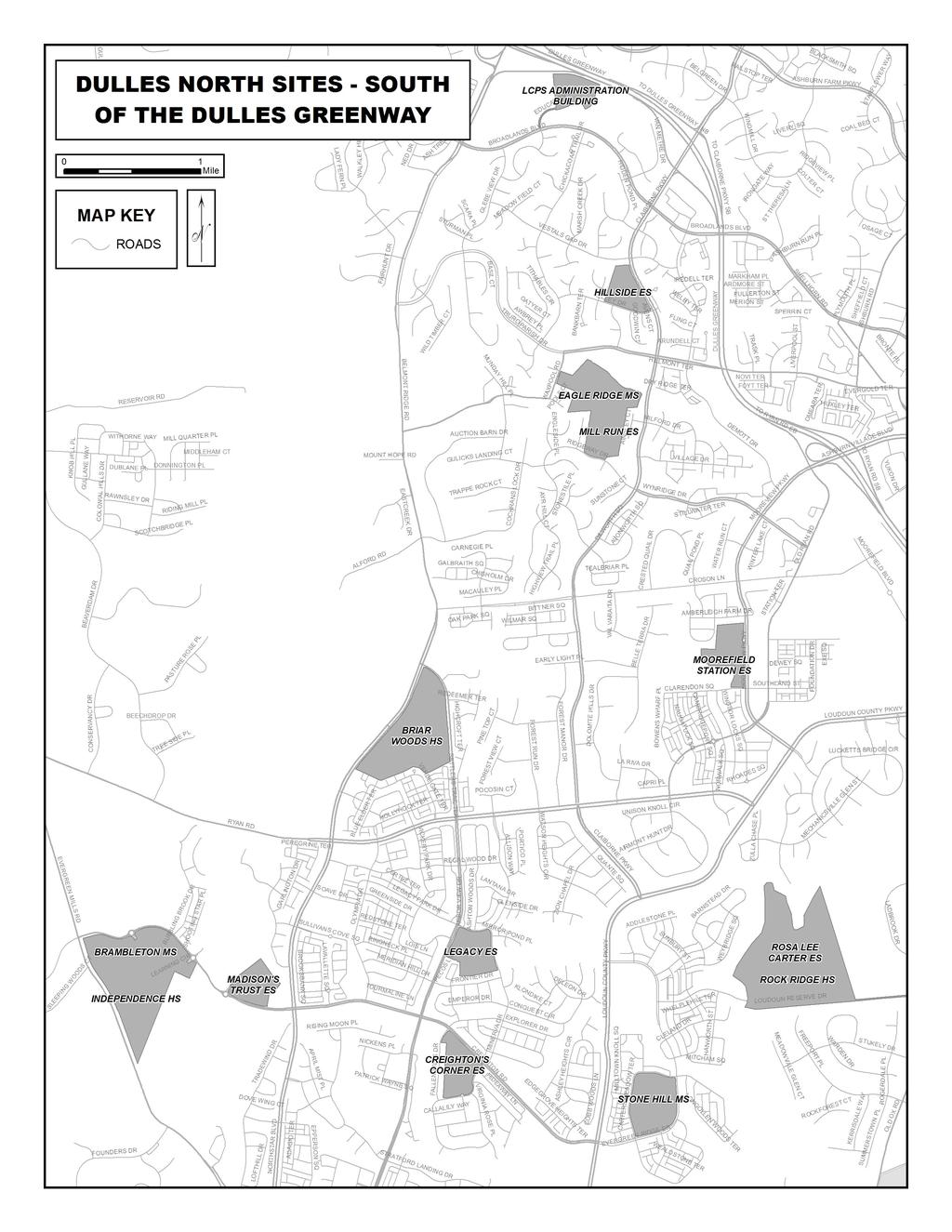
23 DULLES NORTH BRAMBLETON MIDDLE Learning Circle, Leesburg, VA Tel: TBD Travel east on Rt. 7 Bus [E. Market St.] and continue on Rt. 7E towards Sterling. Turn RIGHT onto Belmont Ridge Rd. Belmont Ridge Road becomes Northstar Boulevard. Turn RIGHT onto Creighton Road. School is on the left. Travel north on Dulles Airport Access Road and merge onto Rt. 28 (N) [Sully Road]. Exit LEFT (W) at Rt. 625 [Waxpool Road]. Turn LEFT (S) onto Loudoun County Parkway. Follow Loudoun County Pkwy to Ryan Road. Turn right onto Ryan Road. Turn LEFT onto Northstar Boulevard. Turn RIGHT onto Creighton Rd. School is on the left. Travel north on Dulles Airport Access Road and merge onto Rt. 267 (W) [Dulles Greenway]. At Rt. 267 Exit 7, take the Loudoun County Parkway (W). Turn right onto Ryan Road. Turn LEFT onto Northstar Boulevard. Turn RIGHT on Creighton Rd. School is on the left. BRIAR WOODS HIGH Belmont Ridge Road, Ashburn, Virginia Tel: (703) Travel east on E. Market Street, and continue on Rt. 7E towards Sterling. Turn RIGHT (S) onto Belmont Ridge Road. to follow Belmont Ridge Road. School is on the right. Follow road turning LEFT Travel north on Dulles Airport Access Road and merge onto Rt. 28 (N) [Sully Road]. Exit LEFT (W) at Rt. 625 [Waxpool Road], which becomes Rt. 640 [Farmwell Road]. Turn LEFT (S) onto Loudoun County Parkway. Follow Loudoun County Pkwy to Ryan Road. Turn right onto Ryan Road. Follow to Belmont Ridge Road intersection and turn RIGHT. School entrance is on the LEFT. Travel north on Dulles Airport Access Road and merge onto Rt. 267 (W) [Dulles Greenway]. At Rt. 267 Exit 7, take the Loudoun County Parkway (W). Turn right onto Ryan Road. Turn RIGHT (N) onto Belmont Ridge Road. School is on left. CREIGHTON S CORNER ELEMENTARY Minerva Drive, Ashburn, VA Tel: (703) Travel east on Rt. 7 Bus [E. Market St.] and continue on Rt. 7E towards Sterling. Turn RIGHT onto Belmont Ridge Rd. Follow road turning left to follow Belmont Ridge Rd. Continue past Briar Woods HS on the right. Turn LEFT onto Creighton Rd. School is on the right. Travel north on Dulles Airport Access Road and merge onto Rt. 28 (N) [Sully Road]. Exit LEFT (W) at Rt. 625 [Waxpool Road]. Turn LEFT (S) onto Loudoun County Parkway. Follow Loudoun County Pkwy to Ryan Road. Turn right onto Ryan Road. Turn LEFT onto Belmont Ridge Rd. Turn LEFT onto Creighton Rd. School is on the right. Travel north on Dulles Airport Access Road and merge onto Rt. 267 (W) [Dulles Greenway]. At Rt. 267 Exit 7, take the Loudoun County Parkway (W). Turn right onto Ryan Road. Turn LEFT onto Belmont Ridge Rd. Turn LEFT on Creighton Rd. School is on the right. EAGLE RIDGE MIDDLE Waxpool Road, Ashburn, VA Tel: (571) Travel east on Rt. 7 Bus [E. Market St.], and continue on Rt. 7E towards Sterling. Turn RIGHT (S) onto Belmont Ridge Road [Rt. 659]. Turn LEFT on Truro Parish Road. Turn RIGHT on Waxpool Road. School is on the left. Travel north on Dulles Airport Access Road and merge onto Rt. 28 (N) [Sully Road]. Exit LEFT (W) at Rt. 625 [Waxpool Road], which becomes Rt. 640 [Farmwell Road] and Ashburn Farm Pkwy. Turn LEFT (S) onto Claiborne Parkway. Follow Claiborne Pkwy and turn RIGHT (W) onto Waxpool Road. Follow Waxpool Road as it turns left. School is on the left. Travel north on Dulles Airport Access Road and merge onto Rt. 267 (W) [Dulles Greenway]. Exit Rt. 267 Exit 5 [Claiborne Parkway] and turn LEFT (SW). Follow Claiborne Pkwy and turn RIGHT (W) onto Waxpool Road. Follow Waxpool Road as it turns left. School is on the left. 23
24 DULLES NORTH ES 31 Address: TBD A site must be acquired for the construction of ES 31. Directions to ES 31 will come later on. A site must be acquired for the construction of ES 31. Directions to ES 31 will come later on. A site must be acquired for the construction of ES 31. Directions to ES 31 will come later on. HILLSIDE ELEMENTARY Ellzey Drive, Ashburn, VA Tel: (571) Travel east on Rt. 7 Bus [E. Market St.] and continue on Rt. 7E towards Sterling. Exit RIGHT (S) on Rt. 901 [Claiborne Parkway]. Pass exits for Rt Turn RIGHT (W) onto Ellzey Drive. School is on the right. Travel north on Dulles Airport Access Road and merge onto Rt. 28 (N)[Sully Road]. Exit LEFT to 625 [Waxpool Road]. Continue west (name changes to Farmwell Road, then to Ashburn Farm Parkway) and turn LEFT (S) on Claiborne Pkwy. Turn RIGHT (W) onto Ellzey Drive. School is on the right. Travel north on Dulles Airport Access Road and merge onto Rt. 267 (W) [Dulles Greenway]. At Rt. 267 Exit 5, turn off onto ramp. Turn LEFT (S) onto Claiborne Parkway and drive under overpass. Turn RIGHT (W) onto Ellzey Drive. School is on the right. INDEPENDENCE HIGH Address: TBD Independence High School is co-located with Brambleton Middle School. Directions to Independence High School will be coming later on. Independence High School is co-located with Brambleton Middle School. Directions to Independence High School will be coming later on. Independence High School is co-located with Brambleton Middle School. Directions to Independence High School will be coming later on. LCPS ADMINISTRATION BUILDING Education Court, Ashburn, VA Tel: (571) Travel east on Rt. 7 Bus [E. Market St.] and continue on Rt. 7E towards Sterling. Exit RIGHT (S) on Rt. 901 [Claiborne Parkway]. Pass exits for Rt Turn RIGHT (W) on Broadlands Blvd. Turn RIGHT (N) into Education Court. Travel north on Dulles Airport Access Road and merge onto Rt. 28 (N)[Sully Road]. Exit LEFT to 625 [Waxpool Road]. Continue west (name changes to Farmwell Road, then Ashburn Farm Pkwy). Turn LEFT (S) on Claiborne Parkway. Pass exits for Rt Turn RIGHT (W) on Broadlands Blvd. Turn RIGHT (N) into Education Court. Travel north on Dulles Airport Access Road and merge onto Rt. 267 (W) [Dulles Greenway]. Take Exit 5 off of Rt. 267, and turn LEFT (S) on Claiborne Parkway. Turn RIGHT (W) on Broadlands Blvd. Turn RIGHT (N) into Education Court. 24
25 DULLES NORTH LEGACY ELEMENTARY Minerva Drive, Ashburn, Virginia Tel: (703) Travel east on E. Market Street and continue on Rt. 7E towards Sterling. Turn RIGHT (S) onto Belmont Ridge Road [Rt. 659]. Follow Belmont Ridge Rd as it turns left. Continue past Briar Woods HS on the right. Turn LEFT on Legacy Park Drive. Continue past school, turning right on Minerva Drive to enter parking lot. Travel north on Dulles Airport Access Road and merge onto Rt. 28 (N)[Sully Road]. Exit LEFT to 625 [Waxpool Road]. Turn LEFT (S) on Loudoun County Pkwy. Turn right onto Ryan Road. Turn LEFT on Belmont Ridge Road. Turn LEFT on Legacy Park Drive. Continue past school, turning right on Minerva Drive to enter parking lot. Travel north on Dulles Airport Access Road and merge onto Rt. 267 (W) [Dulles Greenway]. At Rt. 267 Exit 7, take Loudoun County Parkway (W). Turn right onto Ryan Road. Turn LEFT (S) on Belmont Ridge Road. Turn LEFT on Legacy Park Drive. Continue past school, turning right on Minerva Drive to enter parking lot. MADISON S TRUST ELEMENTARY Creighton Road, Ashburn, VA Tel: TBD Travel east on Rt. 7 Bus [E. Market St.] and continue on Rt. 7E towards Sterling. Turn RIGHT onto Belmont Ridge Rd. Continue straight at Northstar Blvd. (Do not turn left to follow Belmont Ridge Rd.) Continue past Briar Woods HS on the left. Turn RIGHT onto Creighton Rd. School is on the right. Travel north on Dulles Airport Access Road and merge onto Rt. 28 (N) [Sully Road]. Exit LEFT (W) at Rt. 625 [Waxpool Road]. Turn LEFT (S) onto Loudoun County Parkway. Follow Loudoun County Pkwy to Ryan Road. Turn right onto Ryan Road. Turn LEFT onto Northstar Blvd. Turn RIGHT onto Creighton Rd. School is on the right. Travel north on Dulles Airport Access Road and merge onto Rt. 267 (W) [Dulles Greenway]. At Rt. 267 Exit 7, take the Loudoun County Parkway (W). Turn right onto Ryan Road. Turn LEFT onto Northstar Blvd. Turn RIGHT on Creighton Rd. School is on the right. MILL RUN ELEMENTARY Ridgeway Drive, Ashburn, VA Tel: (571) Travel east on Rt. 7 Bus [E. Market St.], and continue on Rt. 7E towards Sterling. Turn RIGHT (S) onto Belmont Ridge Road [Rt. 659]. Turn LEFT (E) onto Ashburn Farm Road. Turn RIGHT (S) onto Claiborne Parkway and drive under over pass. Cross Waxpool Road, and turn RIGHT on Ridgeway Drive. School is on right, turn RIGHT to enter school grounds. Travel north on Dulles Airport Access Road and merge onto Rt. 28 (N) [Sully Road]. Exit LEFT to 625 [Waxpool Road], which becomes Rt. 640 [Farmwell Road] and then Ashburn Farm Parkway. Turn LEFT (S) onto Claiborne Parkway. Follow Claiborne Pkwy and turn RIGHT (W) onto Waxpool Road. Follow Waxpool Road as it turns left. Drive past Eagle Ridge Middle School on the left. Mill Run Elementary School is on the left further ahead. Travel north on Dulles Airport Access Road and merge onto Rt. 267 (W) [Dulles Greenway]. Exit Rt. 267 Exit 5 [Claiborne Parkway] and turn LEFT (SW). Follow Claiborne Pkwy and turn RIGHT (W) onto Waxpool Road. Follow Waxpool Road as it turns left. Drive past Eagle Ridge Middle School on the left. Mill Run ES is on the left further ahead. MOOREFIELD STATION ELEMENTARY Mooreview Parkway, Ashburn, VA Tel: (571) Travel east on Rt. 7 Bus [E. Market St.] and continue on Rt. 7E towards Sterling. Exit RIGHT (S) onto Ashburn Village Blvd. which becomes Mooreview Pkwy. School entrance is on right. Travel north on Dulles Airport Access Road and merge onto Rt. 28 (N) [Sully Road]. Exit LEFT (W) at Rt. 625 [Waxpool Road], which becomes Rt. 640 [Farmwell Road]. Continue NW and turn LEFT (S) onto Ashburn Village Blvd. which becomes Mooreview Pkwy. School entrance is on right. Travel north on Dulles Airport Access Road and merge onto Rt. 267 (W) [Dulles Greenway]. Take Exit 6 Rt Turn LEFT (S) at end of ramp onto Mooreview Pkwy. School entrance is on right. 25
26 DULLES NORTH ROCK RIDGE HIGH Loudoun Reserve Drive, Ashburn, VA Tel: (703) Travel east on E. Market Street, and continue on Rt. 7E towards Sterling. Turn RIGHT (S) onto Belmont Ridge Road [Rt. 659]. Turn LEFT at Northstar Blvd. to follow Belmont Ridge Road. Continue past Briar Woods HS on the right. Turn LEFT onto Ryan Road. Turn RIGHT onto Claiborne Pkwy. Turn RIGHT onto Loudoun County Pkwy. Turn LEFT onto Evergreen Ridge Drive. Turn LEFT onto Loudoun Reserve Drive. Travel north on Dulles Airport Access Road and merge onto Rt. 28 (N) [Sully Road]. Exit LEFT to VA-625 W [Waxpool Road]. Turn LEFT (S) on Loudoun County Pkwy. Turn LEFT onto Evergreen Ridge Drive. Turn LEFT onto Loudoun Reserve Drive. School entrance is on the left. Travel north on Dulles Airport Access Road and merge onto Rt. 267 (W) [Dulles Greenway]. At Rt. 267 Exit 7, take Loudoun County Pkwy (W). Turn LEFT onto Evergreen Ridge Drive. Turn LEFT onto Loudoun Reserve Drive. School entrance is on the left. ROSA LEE CARTER ELEMENTARY Loudoun Reserve Drive, Ashburn, VA Tel: (703) Travel east on E. Market Street, and continue on Rt. 7E towards Sterling. Turn RIGHT (S) onto Belmont Ridge Road [Rt. 659]. Turn LEFT at Northstar Blvd. to follow Belmont Ridge Road. Continue past Briar Woods HS on the right. Turn LEFT onto Ryan Road. Turn RIGHT onto Claiborne Pkwy. Turn RIGHT onto Loudoun County Pkwy. Turn LEFT onto Evergreen Ridge Drive. Turn LEFT onto Loudoun Reserve Drive. Travel north on Dulles Airport Access Road and merge onto Rt. 28 (N)[Sully Road]. Exit LEFT to 625 [Waxpool Road]. Turn LEFT (S) on Loudoun County Pkwy. Turn LEFT onto Evergreen Ridge Drive. Turn LEFT onto Loudoun Reserve Drive. School entrance is on the left. Travel north on Dulles Airport Access Road and merge onto Rt. 267 (W) [Dulles Greenway]. At Rt. 267 Exit 7, take Loudoun County Pkwy (W). Turn LEFT onto Evergreen Ridge Drive. Turn LEFT onto Loudoun Reserve Drive. STONE HILL MIDDLE Evergreen Ridge Drive, Ashburn, VA Tel: (703) Travel east on E. Market Street, and continue on Rt. 7E towards Sterling. Turn RIGHT (S) onto Belmont Ridge Road [Rt. 659]. Turn LEFT at Northstar Blvd to follow Belmont Ridge Road. Continue past Briar Woods HS on the right. Turn LEFT onto Ryan Road. Turn RIGHT on Claiborne Pkwy. Turn RIGHT onto Loudoun County Pkwy. Turn LEFT onto Evergreen Ridge Drive. School is on the right. Travel north on Dulles Airport Access Road and merge onto Rt. 28 (N)[Sully Road]. Exit LEFT to 625 [Waxpool Road]. Turn LEFT (S) on Loudoun County Pkwy. Turn LEFT onto Evergreen Ridge Drive. School is on the right. Travel north on Dulles Airport Access Road and merge onto Rt. 267 (W) [Dulles Greenway]. Take exit 7 Loudoun County Parkway (W). Turn LEFT onto Evergreen Ridge Drive. School is on the right. 26
27 Page is intentionally blank. 27
28 28
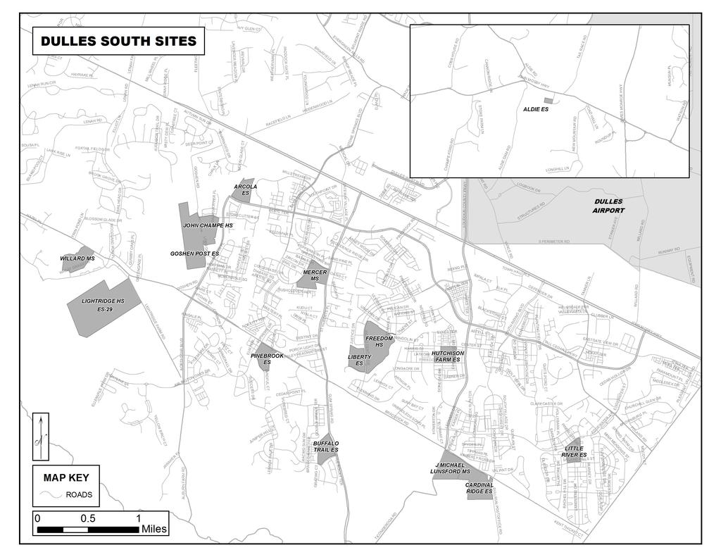
29 DULLES SOUTH ALDIE ELEMENTARY Meetinghouse Lane, Aldie, VA Tel: (703) Travel south on King Street [Rt. 15 Bus]. Continue on Rt. 15 (S) to John Mosby Hwy [Rt. 50]. Proceed through the traffic circle, following Rt. 50 (W). Continue on Rt. 50 (W) to Aldie. In Aldie, turn LEFT (S) onto Meetinghouse Lane and cross over small, narrow bridge. School is on the right. Travel north on Dulles Airport Access Road and merge onto Rt. 28 (S) [Sully Road]. Merge onto Rt. 50 (W). In Aldie, turn LEFT (S) onto Meetinghouse Lane after crossing over small, narrow bridge. School is on the right. Travel north on Dulles Airport Access Road and merge onto RT 267-West [Dulles Greenway]. Take EXIT 8A onto RT 606-West [Old Ox Road], which becomes Loudoun County Parkway. Turn RIGHT (W) onto RT 50-West [John Mosby Highway]. Continue on RT 50-West, proceeding through three traffic circles following signs to RT 50-West. In Aldie, turn LEFT (S) onto Meetinghouse Lane. School is on RIGHT. ARCOLA ELEMENTARY Tall Cedars Parkway, Aldie, VA Tel: (703) Travel south on King Street [Rt. 15 Bus]. Continue on Rt. 15 (S) to John Mosby Hwy [Rt. 50]. Proceed through the traffic circle, following onto Rt. 50 (E). Continue on Rt. 50 (E), proceeding through two additional traffic circles following signs to Rt. 50 (E). Turn RIGHT onto Stone Springs Blvd. Turn RIGHT onto Tall Cedars Pkwy. School is on the right. Travel north on Dulles Airport Access Road and merge onto Rt. 28 (S) [Sully Road]. Merge onto Rt. 50 (W). Turn LEFT (S) onto Stone Springs Blvd. Turn RIGHT onto Tall Cedars Pkwy. School is on the right. Travel north on Dulles Airport Access Road and merge onto RT 267-West [Dulles Greenway]. Take EXIT 8A onto RT 606-West [Old Ox Road], which becomes Loudoun County Parkway. Turn RIGHT (W) onto RT 50-West [John Mosby Highway]. Turn LEFT (S) onto Stone Springs Boulevard. Turn RIGHT (W) onto Tall Cedars Parkway. School is on RIGHT. BUFFALO TRAIL ELEMENTARY Seven Hills Drive, Aldie, VA Tel: (703) Travel south on King Street [Rt. 15 Bus] and continue on Rt. 15 (S) to John Mosby Highway [Rt. 50]. Proceed through the traffic circle, following to Rt. 50 (E). Continue on Rt. 50 (E), proceeding through two additional traffic circles following Rt. 50 (E). Turn RIGHT onto Gum Spring Road [Rt. 659]. Continue on Rt. 659-South. Turn RIGHT (W) onto Seven Hills Drive. School will be on the RIGHT. Travel north on Dulles Airport Access Road and merge onto Sully Road [Rt. 28/S]. Merge onto Rt. 50/W. Continue on Rt. 50 (W), entering Loudoun County. Turn LEFT onto Gum Spring Road [Rt. 659]. Continue on Rt. 659-South. Turn RIGHT (W) onto Seven Hills Drive. Travel north on Dulles Airport Access Road and merge onto RT 267-West [Dulles Greenway]. Take EXIT 8A onto RT 606-West [Old Ox Road], which becomes Loudoun County Parkway. Turn RIGHT (W) onto RT 50-West [John Mosby Highway]. Turn LEFT onto RT 659-South [Gum Spring Road]. Continue on RT 659-South. Turn RIGHT (W) onto Seven Hills Drive. School is on RIGHT. CARDINAL RIDGE ELEMENTARY Bullrun Postofice Road, Centreville, VA Tel: (571) Travel south on King Street [Rt. 15 Bus] and continue on Rt. 15 (S) to John Mosby Highway [Rt. 50]. Proceed through the traffic circle, following to Rt. 50 (E). Continue on Rt. 50 (E), proceeding through two additional traffic circles following Rt. 50 (E). Turn RIGHT onto Gum Spring Road [Rt. 659]. Continue on Rt. 659, to the stop light at Braddock Road [Rt. 620]. Turn LEFT (E) onto Braddock Rd. Continue on Braddock Rd. to Bullrun Postoffice Rd. Turn RIGHT. School will be on the RIGHT. Travel north on Dulles Airport Access Road and merge onto Sully Road [Rt. 28/S]. Merge onto Rt. 50/W. Continue on Rt. 50 (W), entering Loudoun County. Turn LEFT onto Loudoun County Parkway (S). Follow south to Braddock Rd. Turn LEFT onto Braddock Rd. Turn LEFT onto Bullrun Postoffice Rd. School will be on the RIGHT. Travel north on Dulles Airport Access Road and merge onto RT 267-West [Dulles Greenway]. Take EXIT 8A onto RT 606-West [Old Ox Road], which becomes Loudoun County Parkway (S). Proceed to Braddock Rd. Turn LEFT onto Braddock Rd. Turn LEFT onto Bullrun Postoffice Rd. 29
30 DULLES SOUTH ES 29 Address: TBD ES 29 is co-located with Lightridge High School. Directions to ES 29 will be provided in the future. ES 29 is co-located with Lightridge High School Directions to ES 29 will be provided in the future. ES 29 is co-located with Lightridge High School. Directions to ES 29 will be provided in the future. FREEDOM HIGH Riding Center Drive, South Riding, VA Tel: (703) Travel south on King Street [Rt. 15 Bus]. Continue on Rt. 15 (S) to John Mosby Hwy [Rt. 50]. Proceed through the traffic circle, following onto Rt. 50 (E). Continue on Rt. 50 (E), proceeding through two additional traffic circles following signs to Rt. 50 (E).Turn RIGHT (S) onto Loudoun County Pkwy. Turn RIGHT (SW) onto Riding Center Drive. School is on the left. Travel north on Dulles Airport Access Road and merge onto Rt. 28 (S) [Sully Road]. Merge onto Rt. 50 (W). Turn LEFT (S) onto Loudoun County Parkway. Turn RIGHT (SW) onto Riding Center Drive. School is on the left. Travel north on Dulles Airport Access Road and merge onto RT 267-West [Dulles Greenway]. Take EXIT 8A onto RT 606-West [Old Ox Road], which becomes Loudoun County Parkway Proceed on Loudoun County Parkway (S), through RT 50 [John Mosby Highway] intersection. Turn RIGHT (W) onto Riding Center Drive. School is on the LEFT. GOSHEN POST ELEMENTARY Address: TBD Goshen Post Elementary School is co-located with John Champe High School. Directions to Goshen Elementary will be provided in the future. Goshen Post Elementary School is co-located with John Champe High School. Directions to Goshen Elementary will be provided in the future. Goshen Post Elementary School is co-located with John Champe High School. Directions to Goshen Elementary will be provided in the future. HUTCHISON FARM ELEMENTARY Center Street, South Riding, VA Tel: (703) Travel south on King Street [Rt. 15 Bus]. Continue on Rt. 15 (S) to John Mosby Hwy [Rt. 50]. Proceed through the traffic circle, following onto Rt. 50 (E). Continue on Rt. 50 (E), proceeding through two additional traffic circles following signs to Rt. 50 (E).Turn RIGHT (S) onto Loudoun County Parkway. Turn RIGHT (W) onto Center Street. School is on the left. Travel north on Dulles Airport Access Road and merge onto Rt. 28 (S) [Sully Road]. Merge onto Rt. 50 (W) towards South Riding. Turn LEFT (SW) onto Loudoun County Parkway. Turn RIGHT (W) onto Center Street. School is on the left. Travel north on Dulles Airport Access Road and merge onto RT 267-West [Dulles Greenway]. Take EXIT 8A onto RT 606-West [Old Ox Road], which becomes Loudoun County Parkway Proceed on Loudoun County Parkway (S), through RT 50 [John Mosby Highway] intersection. Turn RIGHT (W) onto Center Street. School is on LEFT. 30
31 DULLES SOUTH J. MICHAEL LUNSFORD MIDDLE Ticonderoga Road, Chantilly, VA Tel: (703) Travel south on King Street [Rt. 15 Bus] and continue on Rt. 15 (S) to John Mosby Highway [Rt. 50]. Proceed through the traffic circle, following to Rt. 50 (E). Continue on Rt. 50 (E), proceeding through two additional traffic circles following Rt. 50 (E). Turn RIGHT onto Gum Spring Road [Rt. 659]. Continue on Rt. 659, to the stop light at Braddock Road [Rt. 620]. Turn LEFT (E) onto Braddock Rd. Continue on Braddock Rd. to Ticonderoga Rd. Turn RIGHT. School will be on the LEFT. Travel north on Dulles Airport Access Road and merge onto Sully Road [Rt. 28/S]. Merge onto Rt. 50/W. Continue on Rt. 50 (W), entering Loudoun County. Turn LEFT onto Loudoun County Parkway (S). Follow Loudoun County Pkwy (S) to Braddock Rd. Continue crossing Braddock Rd onto Ticonderoga Rd. School will be on the LEFT. Travel north on Dulles Airport Access Road and merge onto RT 267-West [Dulles Greenway]. Take EXIT 8A onto RT 606-West [Old Ox Road], which becomes Loudoun County Parkway Continue on Loudoun County Parkway (S), through the traffic light at RT 50 [John Mosby Highway]. Proceed on Loudoun County Parkway (S) to Braddock Road, crossing Braddock Road, onto Ticonderoga Road. School is on LEFT. JOHN CHAMPE HIGH Sacred Mountain Street, Aldie, VA Tel: (703) Travel south on RT 15-Business [King Street]. Continue on RT 15-South to RT 50 [John Mosby Highway]. Proceed through traffic circle, merging onto RT 50-East. Continue on RT 50-East, proceeding through two additional traffic circles following signs to RT 50-East. Turn RIGHT (S) onto Stone Springs Boulevard. Turn RIGHT (W) onto Tall Cedars Parkway. Turn LEFT (S) onto Northstar Boulevard. Continue past the school on your right to Conejo Way and turn RIGHT (W). Follow Conejo Wy to Lobo Dr. Turn RIGHT (N) and proceed to parking lot on RIGHT. Travel north on Dulles Airport Access Road and merge onto RT 28-South [Sully Road]. Merge onto RT 50-West. Enter Loudoun County, remaining on RT 50-West. Turn LEFT (S) onto Stone Springs Boulevard. Turn RIGHT (W) onto Tall Cedars Parkway. Turn LEFT (S) onto Northstar Boulevard. Continue past the school on your right to Conejo Way and turn RIGHT (W). Follow Conejo Way to Lobo Dr. Turn RIGHT (N) and proceed to parking lot on RIGHT. Airport Access Road and merge onto RT 267-West [Dulles Greenway]. Take EXIT 8A onto RT 606-West [Old Ox Road], which becomes Loudoun County Parkway. Turn RIGHT (W) onto RT 50-West [John Mosby Highway]. Turn LEFT (S) onto Stone Springs Boulevard. Turn RIGHT (W) onto Tall Cedars Parkway. Turn LEFT (S) onto Northstar Boulevard. Continue past the school on your right to Conejo Way and turn RIGHT (W). Follow Conejo Way to Lobo Dr. Turn RIGHT (N) and proceed to parking lot on RIGHT. LIBERTY ELEMENTARY Riding Center Drive, South Riding, VA Tel: (703) Travel south on King Street [Rt. 15 Bus]. Continue on Rt. 15 (S) to John Mosby Hwy [Rt. 50]. Proceed through the traffic circle, following onto Rt. 50 (E). Continue on Rt. 50 (E), proceeding through two additional traffic circles following signs to Rt. 50 (E). Turn RIGHT (S) onto Loudoun County Parkway. Turn RIGHT (SW) onto Riding Center Drive. School is on the right. Travel north on Dulles Airport Access Road and merge onto Rt. 28 (S) [Sully Road]. Merge onto Rt. 50 (W). Turn LEFT (S) onto Loudoun County Parkway. Turn RIGHT (SW) onto Riding Center Drive. School is on the right, across from Freedom High School. Travel north on Dulles Airport Access Road and merge onto RT 267-West [Dulles Greenway]. Take EXIT 8A onto RT 606-West [Old Ox Road], which becomes Loudoun County Parkway Proceed on Loudoun County Parkway (S), through RT 50 [John Mosby Highway] intersection. Turn RIGHT (W) onto Riding Center Drive. School is on the RIGHT. 31
32 DULLES SOUTH LIGHTRIDGE HIGH Address: TBD Directions to Lightridge High School will be provided in the future. Directions to Lightridge High School will be provided in the future. Directions to Lightridge High School will be provided in the future. LITTLE RIVER ELEMENTARY Hyland Hills Street, South Riding, VA Tel: (703) Travel south on King Street [Rt. 15 Bus]. Continue on Rt. 15 (S) to John Mosby Hwy [Rt. 50]. Proceed through the traffic circle, following onto Rt. 50 (E). Continue on Rt. 50 (E), proceeding through two additional traffic circles following signs to Rt. 50 (E).Turn RIGHT (S) onto Poland Road. Turn RIGHT (SW) onto Edgewater Street. Follow Edgewater about 0.5 miles. Turn LEFT (S) onto Priesters Pond Drive. School is on the right. Turn RIGHT (W) onto Hyland Hills to enter at front of school. Travel north on Dulles Airport Access Road and merge onto Rt. 28 (S) [Sully Road]. Turn RIGHT (W) on Rt. 50 and then turn LEFT (S) onto Poland Road. Turn RIGHT (SW) onto Edgewater Street. Follow Edgewater about 0.5 miles. Turn LEFT (S) onto Priesters Pond Drive. School is on the right. Turn RIGHT (W) onto Hyland Hills to enter at front of school. Travel north on Dulles Airport Access Road and merge onto RT 267-West [Dulles Greenway]. Take EXIT 8A onto RT 606-West [Old Ox Road], which becomes Loudoun County Parkway Proceed on Loudoun County Parkway (S), through RT 50 [John Mosby Highway] intersection. Turn LEFT (E) onto Edgewater Drive. Turn RIGHT (S) onto Rachel Hill Drive. School is on LEFT. Turn LEFT onto Hyland Hills Street to enter at front of school. MERCER MIDDLE Greenstone Drive, Aldie, VA Tel: (703) Travel south on King Street [Rt. 15 Bus]. Continue on Rt. 15 (S) to John Mosby Hwy [Rt. 50]. Proceed through the traffic circle, following onto Rt. 50 (E). Continue on Rt. 50 (E), proceeding through two additional traffic circles following signs to Rt. 50 (E). Turn RIGHT (S) on Rt. 659 [Gum Spring Road]. Turn RIGHT on Greenstone Drive. School is on the left. Travel north on Dulles Airport Access Road and merge onto Rt. 28 (S) [Sully Road]. Merge onto Rt. 50 W. Turn LEFT (S) on Rt. 659 [Gum Spring Road]. Turn RIGHT on Greenstone Drive. School is on the left. Turn LEFT to enter school grounds. Travel north on Dulles Airport Access Road and merge onto RT 267-West [Dulles Greenway]. Take EXIT 8A onto RT 606-West [Old Ox Road], which becomes Loudoun County Parkway. Turn RIGHT (W) onto RT 50-West [John Mosby Highway]. Turn LEFT onto RT 659-South [Gum Spring Road]. Turn RIGHT onto Greenstone Drive. School is on LEFT. PINEBROOK ELEMENTARY Mindful Court, Aldie, VA Tel: (703) Travel south on King Street [Rt. 15 Bus]. Continue on Rt. 15 (S) to John Mosby Hwy [Rt. 50]. Proceed through the traffic circle, following onto Rt. 50 (E). Continue on Rt. 50 (E), proceeding through two additional traffic circles following signs to Rt. 50 (E). Turn RIGHT (S) on Rt. 659 [Gum Spring Road]. Turn RIGHT (W) onto Braddock Road. Turn LEFT (S) onto Summerall Drive. Turn LEFT onto Mindful Court. School is on the left. Travel north on Dulles Airport Access Road and merge onto Rt. 28 (S) [Sully Road]. Merge onto Rt. 50 (W). Turn LEFT (S) onto Rt. 659 [Gum Spring Road]. Turn RIGHT (W) onto Braddock Road. Turn LEFT (S) onto Summerall Drive. Turn LEFT onto Mindful Court. School is on the left. Travel north on Dulles Airport Access Road and merge onto RT 267-West [Dulles Greenway]. Take EXIT 8A onto RT 606-West [Old Ox Road], which becomes Loudoun County Parkway. Turn RIGHT (W) onto RT 50-West [John Mosby Highway]. Turn LEFT onto RT 659-South [Gum Spring Road]. Turn RIGHT (W) on Braddock Road. Turn LEFT (S) onto Summerall Drive. Turn LEFT onto Mindful Court. School is on LEFT. 32

33 DULLES SOUTH WILLARD MIDDLE Address: TBD Directions to Willard Middle School will be provided in the future. Directions to Willard Middle School will be provided in the future. Directions to Willard Middle School will be provided in the future. 33
34 34
35 35
36 EASTERN LOUDOUN ALGONKIAN ELEMENTARY Carter Court, Sterling, VA Tel: (571) Travel east on Rt. 7 Bus [E. Market St.] and continue on Rt. 7E for about 9 miles. Exit Rt (N) [Algonkian Parkway]. Pass intersection with Countryside Blvd. School is on left. Turn LEFT (N) onto Carter Court to enter school grounds. Travel north on Dulles Airport Access Road and merge onto Rt. 28 (N) [Sully Road]. Merge onto Rt. 7E (SE). Turn LEFT onto Countryside Blvd. Turn RIGHT (N) onto Algonkian Parkway. School is on left. Turn LEFT (N) onto Carter Court to enter school grounds. COUNTRYSIDE ELEMENTARY Countryside Boulevard, Sterling, VA Tel: (571) Travel east on Rt. 7 Bus [E. Market St.] and continue on Rt. 7E for about 9 miles. Exit Rt (N) [Algonkian Parkway]. Turn RIGHT (NE) onto Countryside Blvd. Turn LEFT on Cromwell Road and then LEFT to enter school grounds. Travel north on Dulles Airport Access Road and merge onto Rt. 28 (N) [Sully Road]. Merge onto Rt. 7E (SE). Turn LEFT onto Countryside Blvd. Turn RIGHT on Cromwell Road and then LEFT to enter school grounds. DOMINION HIGH Augusta Drive, Sterling, VA Tel: (571) Travel east on Rt. 7 Bus [E. Market St.] and continue on Rt. 7E for about 10 miles, then turn LEFT (E) onto Augusta Drive (after Rt. 846/Sterling Blvd). School is on the right. Travel north on Dulles Airport Access Road and merge onto Rt. 28 (N). Merge onto Rt. 7E. Turn LEFT (N) onto Augusta Drive. School is on the right. FOREST GROVE ELEMENTARY Forest Ridge Drive, Sterling, VA Tel: (571) Travel east on Rt. 7 Bus [E. Market St.] and continue on Rt. 7E for about 10 miles. Turn RIGHT (SW) onto Rt. 846 [N. Sterling Blvd]. Turn LEFT (S) onto E. Maple Avenue. Turn RIGHT (S) onto South Fillmore Road (to left it is Providence Village Road). Turn RIGHT (S) onto Forest Ridge Drive. School is on the right. Travel north on Dulles Airport Access Road and merge onto Rt. 28 (N) [Sully Road]. Merge RIGHT (E) onto Rt. 606 [Old Ox Road], which becomes Sterling Road. Turn LEFT (N) onto Herndon Parkway. Turn LEFT (N) onto Crestview Drive. Turn LEFT (NW) onto Forest Ridge Drive. School is on the left. GUILFORD ELEMENTARY 600 W Poplar Road, Sterling, VA Tel: (571) Travel east on Rt. 7 Bus [E. Market St.] and continue on Rt. 7E for about 10 miles. Turn RIGHT (SW) onto Rt. 846 [N Sterling Blvd]. Turn RIGHT (NW) onto W Poplar Road. School is on the right. Travel north on Dulles Airport Access Road. and merge onto Rt. 28 (N) [Sully Rd]. Merge RIGHT (E) onto Rt. 846 [S Sterling Blvd]. Turn LEFT (NW) onto W. Poplar Road. School is on the right. 36
37 EASTERN LOUDOUN HORIZON ELEMENTARY Broadmore Drive, Sterling VA Tel: (571) Travel east on Rt. 7 Bus [E. Market St.] and continue on Rt. 7E for about 9 miles. Take the Cascades Parkway North exit onto Cascades Parkway. Continue past Potowmack Elementary School on RIGHT. Turn RIGHT (SE) onto Broadmore Drive. School is on the right. Travel north on Dulles Airport Access Road and merge onto Rt. 28 (N) [Sully Road]. Travel north on Sully Road, then merge onto Rt. 7 (E) towards Sterling. Take the Cascades Parkway North exit onto Cascades Parkway. Continue past Potowmack Elementary School on RIGHT. Turn RIGHT (SE) onto Broadmore Drive. School is on the right. LOWES ISLAND ELEMENTARY Whitewater Drive, Sterling, VA Tel: (571) Travel east on Rt. 7 Bus [E. Market St.] and continue on Rt. 7E towards Sterling. Take the exit RIGHT onto Rt. 604 [Algonkian Parkway] (N). Turn RIGHT (E) onto Whitewater Drive. School is on the left. Travel north on the Dulles Airport Access Road and merge onto Rt. 28 (N). Merge onto Rt. 7 E. Take the exit onto Rt. 604 (N) [Algonkian Parkway]. Turn RIGHT (E) onto Whitewater Drive. School is on the left. MEADOWLAND ELEMENTARY 729 Sugarland Run Drive, Sterling, VA Tel: (571) Travel east on Rt. 7 Bus [E. Market St.] and continue on Rt. 7E towards Sterling. Turn LEFT onto Rt. 637 (E) [Potomac View Road]. Turn RIGHT (E) onto Cottage Road. Turn RIGHT (E) onto Sugarland Run Drive. School is on the left. NOTE: Sugarland Run Drive is a loop. Travel north on the Dulles Airport Access Road and merge onto Rt. 28 (N) [Sully Road]. Merge onto Rt. 7E. Turn LEFT onto Potomac View Road. Turn RIGHT (E) onto Cottage Road. Turn RIGHT (E) onto Sugarland Run Drive. School is on the left. NOTE: Sugarland Run Drive is a loop. PARK VIEW HIGH 400 W Laurel Avenue, Sterling, VA Tel: (571) Travel east on Rt. 7 Bus [E. Market St.] and continue on Rt. 7E towards Sterling for about 10 miles. Turn RIGHT (SW) onto Rt. 846 [N. Sterling Blvd.] Turn RIGHT (NW) onto W. Laurel Avenue. School is at the end of the road. Travel north on Dulles Airport Access Road and merge onto Rt. 28 (N) [Sully Road]. Merge RIGHT (E) onto Rt. 846 [S. Sterling Blvd.]. Turn LEFT (W) onto W. Laurel Avenue. School is at the end of the road. POTOMAC FALLS HIGH Algonkian Parkway, Sterling, VA Tel: (571) Travel east on Rt. 7 Bus [E. Market St.] and continue on Rt. 7E for about 9 miles. Exit RIGHT onto Rt (N) [Algonkian Parkway]. School is on the left past Algonkian ES and River Bend MS. Travel north on Dulles Airport Access Road and merge onto Rt. 28 (N) [Sully Road]. Merge onto Rt. 7E. Exit RIGHT (N) onto Algonkian Pkwy [Rt. 1582]. School is on the left past Algonkian ES and River Bend MS. 37
38 EASTERN LOUDOUN POTOWMACK ELEMENTARY Esterbrook Circle, Sterling, VA Tel: (571) Travel east on Rt. 7 Bus [E. Market St.] and continue on Rt. 7E towards Sterling for 9-10 miles. Take the Cascade Parkway North exit onto Cascades Parkway. Turn RIGHT(SE) onto Esterbrook Circle. School is on the left. Travel north on Dulles Airport Access Road and merge onto Rt. 28 (N) [Sully Road]. Merge onto Rt. 7E. Take the Cascades Parkway North exit onto Cascades Parkway. Cross over Rt. 7 and continue north. Turn RIGHT (SE) onto Esterbrook Circle. School is on the left. RIVER BEND MIDDLE Algonkian Parkway, Sterling, VA Tel: (571) Travel east on Rt. 7 Bus [E. Market St.] and continue on Rt. 7E for about 9 miles. Exit Rt (N) [Algonkian Parkway]. Pass intersection with Countryside Blvd. School is on the left just after Algonkian ES. Travel north on Dulles Airport Access Road and merge onto Rt. 28 (N) [Sully Road]. Merge onto Rt. 7E. Exit RIGHT at Rt (N) [Algonkian Parkway]. Pass intersection with Countryside Blvd. School is on the left just after Algonkian ES. ROLLING RIDGE ELEMENTARY 500 E Frederick Drive, Sterling, VA Tel: (571) Travel east on Rt. 7 Bus [E. Market St.] and continue on Rt. 7E towards Sterling for about 10 miles. Turn RIGHT (SW) onto Rt. 846 [N. Sterling Blvd.] Turn LEFT (SE) onto E. Frederick Drive. School is on the left. Travel north on Dulles Airport Access Road and merge onto Rt. 28 (N) [Sully Road]. Exit RIGHT (E) onto Rt. 846 [S. Sterling Blvd.] for about 3 miles, then turn RIGHT (SE) onto East Frederick Drive. School is on the left. SENECA RIDGE MIDDLE 98 Seneca Ridge Drive, Sterling, VA Tel: (571) Travel east on Rt. 7 Bus [E. Market St.] and continue on Rt. 7E for about 10 miles, then turn LEFT (E) onto Augusta Drive. Turn RIGHT (E) onto Seneca Ridge Drive. School is on the right past Dominion HS. Travel north on Dulles Airport Access Road and merge onto Rt. 28 (N). Merge onto Rt. 7E. Turn LEFT (N) onto Augusta Drive. Pass Dominion High School and turn RIGHT (E) onto Seneca Ridge Drive. School is on the right. STERLING ELEMENTARY 200 W Church Road, Sterling, VA Tel: (571) Travel east on Rt. 7 Bus [E. Market St.] and continue on Rt. 7E for about 10 miles. Turn RIGHT (SW) onto Rt. 846 [N. Sterling Blvd]. Turn RIGHT (W) onto Rt. 625 [W. Church Road]. School is on the right. Travel north on Dulles Airport Access Road and merge onto Rt. 28 (N). Exit RIGHT onto Rt. 625 (E) [Church Road]. School is on the left. 38
39 EASTERN LOUDOUN STERLING MIDDLE 201 W Holly Avenue, Sterling, VA Tel: (571) Travel east on Rt. 7 Bus [E. Market St.] and continue on Rt. 7E towards Sterling for about 10 miles. Turn RIGHT (SW) onto Rt. 846 [N. Sterling Blvd.] School is on the corner of Sterling Blvd. and Holly Avenue. Turn RIGHT (NW) onto W. Holly Avenue to enter school grounds. Travel north on Dulles Airport Access Road and merge onto Rt. 28 (N). After about 2 miles, exit RIGHT (E) onto Rt. 846 [S. Sterling Blvd]. School is on the corner of Sterling Blvd. and Holly Avenue. Turn LEFT (NW) onto W. Holly Avenue to enter school grounds. SUGARLAND ELEMENTARY 65 Sugarland Run Drive, Sterling, VA Tel: (571) Travel east on Rt. 7 Bus [E. Market St.] and continue on Rt. 7E for about 11 miles.turn LEFT (N) onto Rt. 637 [Potomac View Road]. Turn RIGHT (E) onto Sugarland Run Drive. School is at the Y in the road. Go right to parking lot. Travel north on Dulles Airport Access Road and merge onto Rt. 28 (N). Exit RIGHT (E) onto Rt. 846 [S. Sterling Blvd]. Turn LEFT (W) onto Rt. 7, and then RIGHT (N) onto Rt. 637 [Potomac View Road]. Turn RIGHT (E) onto Sugarland Run Drive. School is at the Y in the road. Go right to parking lot. SULLY ELEMENTARY 300 Circle Drive, Sterling, VA Tel: (571) Travel east on Rt. 7 Bus [E. Market St.] and continue on Rt. 7E towards Sterling for about 10 miles. Turn RIGHT (SW) onto Rt. 846 [N. Sterling Blvd]. Turn LEFT (S) on E. Maple Avenue, which becomes Circle Drive. School is on the left. Travel north on Dulles Airport Access Road and merge onto Rt. 28 (N). After about 2 miles, Exit RIGHT (E) onto Rt. 846 [S. Sterling Blvd]. Turn RIGHT (S) on E. Maple Avenue, which becomes Circle Drive. School is on the left. 39
40 40
41 WESTERN LOUDOUN BANNEKER ELEMENTARY Snake Hill Road, Middleburg, VA Tel: (540) Travel south on King Street [Rt. 15 Bus]. Continue on Rt. 15 (S) to John Mosby Hwy [Rt. 50]. Proceed through the traffic circle, following signs onto Rt. 50 (W). Continue on Rt. 50 (W) through Aldie and Middleburg. Turn RIGHT (N) onto Rt. 611 [St. Louis Road]. Turn RIGHT (E) onto Snake Hill Road. School is on the right. Travel north on Dulles Airport Access Road and merge onto Rt. 28 (S) [Sully Road]. Take Rt. 50 (W) through Aldie and Middleburg, and turn RIGHT (N) onto Rt. 611 [St. Louis Road]. Continue north on 611 [St. Louis Road] to Snake Hill Road, and turn RIGHT (E). School is on the right. BLUE RIDGE MIDDLE 551 East A Street, Purcellville, VA Tel: (540) Travel west on Rt. 7 Bus [W. Market St.]. Merge onto Rt. 7(W). Turn off onto ramp and merge left onto Rt. 287 (S) [Berlin Tpke]. Travel south, and turn RIGHT (W) onto Rt. 7 Bus [East Main St.]. Turn LEFT (S) onto S. Maple Ave. Turn RIGHT (W) onto East A St. School is on the right. Travel north on Dulles Airport Access Road and merge onto Rt. 28 (N). Merge onto Rt. 7W. Take first Purcellville exit (Rt. 287) (S) [Berlin Tpke.]. Travel south, and turn RIGHT (W) onto Rt. 7 Bus [East Main St.]. Turn LEFT (S) onto S. Maple Ave. Turn RIGHT (W) onto East A St. School is on the right. Travel north on Dulles Airport Access Road and merge onto Rt. 267 (W) [Dulles Greenway]. At Rt. 267 Exit 1A, follow left ramp. Merge onto Rt. 15 (S) / [Rt. 7 W] Byp. Continue on Rt. 7 (W) past Hamilton to the exit for Rt. 287 in Purcellville. Turn left onto Rt. 287 (S) [Berlin Tpke]. Turn RIGHT (W) onto Rt. 7 Bus [E. Main St.]. Turn LEFT (S) onto S. Maple Ave. Turn RIGHT (W) onto East A St. School is on the right. EMERICK ELEMENTARY 440 S Nursery Avenue, Purcellville, VA Tel: (540) Travel west on Rt. 7 Bus [W. Market St]. Merge onto Rt. 7 (W). Turn off onto ramp and merge left onto Rt. 287 (S) [Berlin Tpke]. Travel south, and turn RIGHT (W) onto Rt. 7 Bus [E. Main St.]. Travel west on Rt. 7 Bus. Turn LEFT (S) onto Rt. 690 [S Nursery Ave]. School is on your left. Travel north on Dulles Airport Access Road and merge onto Rt. 28 (N). Merge onto Rt. 7W. Take first Purcellville exit (Rt. 287) (S) [Berlin Tpke.]. Turn RIGHT (W) onto Rt. 7 Bus [E. Main St]. Continue west on Rt. 7 Bus. Turn LEFT (S) onto Rt. 690 [S. Nursery Ave]. School is on your left. Travel north on Dulles Airport Access Road and merge onto Rt. 267 (W) [Dulles Greenway]. At Rt. 267 Exit 1A, follow left ramp. Merge onto Rt. 15 (S) / [Rt. 7 W] Byp. Continue west on Rt. 7. Take Purcellville / Rt 287 exit. Turn left onto Rt. 287 (S) [Berlin Tpke]. Turn RIGHT (W) onto Rt. 7 Bus [E. Main St]. Continue west on Rt. 7 Bus. Turn LEFT (S) onto Rt. 690 [S. Nursery Ave]. School is on your left. 41
42 WESTERN LOUDOUN HAMILTON ELEMENTARY 54 S Kerr Street, Hamilton, VA Tel: (540) Travel west on Rt. 7 Bus [W. Market St]. Merge onto Rt. 7 (W) and take the Hamilton exit to Rt. 704 [Hamilton Station Road] (S). Turn RIGHT (W) onto Rt. 7 [Rt. 7 Bus]. Stay on Rt. 7 Bus (W), and turn LEFT (S) onto S. Kerr Street. School is at the end of the road. Travel north on Dulles Airport Access Road and merge onto Rt. 28 (N). Merge onto Rt. 7W. Continue west on Rt. 7. Take the Hamilton Exit to Rt. 704 [Hamilton Station Road] (S). Bear RIGHT (W) onto Rt. 7 [Rt. 7 Bus]. Continue west on Rt. 7 Bus [E. Colonial Hwy]. Turn LEFT (S) onto S. Kerr Street. School is at the end of the road. Travel north on Dulles Airport Access Road and merge onto Rt. 267 (W) [Dulles Greenway]. At Rt. 267 Exit 1A, follow left ramp. Merge onto Rt. 15 (S) / [Rt. 7 W] Byp. Continue west on Rt. 7. Take the Hamilton Exit to Rt. 704 [Hamilton Station Road] (S). Bear RIGHT (W) onto Rt. 7 [Rt. 7 Bus]. Continue west on Rt. 7 Bus [E. Colonial Hwy]. Turn LEFT (S) onto S. Kerr Street. School is at the end of the road. HARMONY MIDDLE West Colonial Highway, Hamilton, VA Tel: (540) Travel west on Rt. 7 Bus [W. Market St.]. Merge onto Rt. 7 (W). Turn off onto ramp and merge left onto Rt. 287 (S) [Berlin Tpke]. Turn LEFT (E) onto Rt. 7 [West Colonial Hwy/Main Street]. School is on left. Travel north on Dulles Airport Access Road and merge onto Rt. 28 (N) [Sully Road]. Merge onto Rt. 7W. Continue west on Rt. 7. Merge left onto Rt. 287 [Berlin Turnpike] (S). Turn LEFT (E) onto Rt. 7 [West Colonial Hwy/Main Street]. School is on left. Travel north on Dulles Airport Access Road and merge onto Rt. 267 (W) [Dulles Greenway]. At Rt. 267 Exit 1A, follow left ramp. Merge onto Rt. 15 (S) / [Rt. 7 W] Byp. Continue west on Rt. 7. Take Purcellville / Rt 287 exit. Turn left onto Rt. 287 (S) [Berlin Tpke]. Turn LEFT (E) onto Rt. 7 [West Colonial Hwy/Main Street]. School is on left. HILLSBORO CHARTER ACADEMY Charles Town Pike, Purcellville, VA Tel: (540) Travel west onto Rt. 7 Bus [W. Market St.].Turn off onto ramp and merge onto Rt. 7 (NW). Take exit for Rt. 9W [Charles Town Pike] and continue north. School is on RIGHT (N) as you enter the town of Hillsboro, opposite the junction with Rt. 690 [Hillsboro Road]. Travel north on Dulles Airport Access Road and merge onto Rt. 28 (N) [Sully Road]. Merge onto Rt. 7W. Continue west on Rt. 7. Take exit for Rt. 9W [Charles Town Pike] and continue north. School is on RIGHT (N) opposite the junction with Rt. 690 [Hillsboro Road]. Travel north on Dulles Airport Access Road and merge onto Rt. 267 (W) [Dulles Greenway]. At Rt. 267 Exit 1A, follow left ramp. Merge onto Rt. 15 (S) / [Rt. 7 W] Byp. Continue west Rt. 7 (W). Take exit for Rt. 9W [Charles Town Pike]. School is on RIGHT (N) opposite the junction with Rt. 690 [Hillsboro Road]. 42
43 WESTERN LOUDOUN KENNETH W. CULBERT ELEMENTARY West Colonial Highway, Hamilton, VA Tel: (540) Travel west on Rt. 7 Bus [W. Market St.]. Merge onto Rt. 7 (W). Turn off onto ramp and merge left onto Rt. 287 (S) [Berlin Tpke]. Turn LEFT (E) onto Rt. 7 [West Colonial Hwy/Main Street]. School is located behind Harmony Middle School. Travel north on Dulles Airport Access Road and merge onto Rt. 28 (N) [Sully Road]. Merge onto Rt. 7W. Continue west on Rt. 7. Merge left onto Rt. 287 [Berlin Turnpike] (S). Turn LEFT (E) onto Rt. 7 [West Colonial Hwy/Main Street]. School is located behind Harmony Intermediate/Middle School. Travel north on Dulles Airport Access Road and merge onto Rt. 267 (W) [Dulles Greenway]. At Rt. 267 Exit 1A, follow left ramp. Merge onto Rt. 15 (S) / [Rt. 7 W] Byp. Continue west on Rt. 7. Take Purcellville / Rt 287 exit. Turn left onto Rt. 287 (S) [Berlin Tpke]. Turn LEFT (E) onto Rt. 7 [West Colonial Hwy/Main Street]. School is located behind Harmony Middle School. LINCOLN ELEMENTARY Lincoln Road, Purcellville, VA Tel: (540) Travel west on Rt. 7 Bus [W. Market St.]. Merge onto Rt. 7(W). Turn off onto ramp and merge left onto Rt. 287 (S) [Berlin Tpke]. Continue south and then turn RIGHT (W) onto Rt. 7 Bus [E. Main St.]. Turn LEFT (S) onto S. Maple Avenue, which will become Lincoln Road (SE). School is on the left as you enter the village. Travel north on Dulles Airport Access Road and merge onto Rt. 28 (N) [Sully Road]. Merge onto Rt. 7W. Continue west on Rt. 7 and merge left onto Rt. 287 (S) [Berlin Tpke]. Turn RIGHT (W) onto Rt. 7 Bus [E. Main St.]. Turn LEFT (S) onto S. Maple Avenue (becomes Lincoln Road) (SE). School is on the left as you enter the village. Travel north on Dulles Airport Access Road and merge onto Rt. 267 (W) [Dulles Greenway]. At Rt. 267 Exit 1A, follow left ramp. Merge onto Rt. 15 (S) / [Rt. 7 W] Byp. Take Purcellville / Rt 287 exit. Turn left onto Rt. 287 (S) [Berlin Tpke]. Turn RIGHT (W) onto Rt. 7 Bus [E. Main St.]. Turn LEFT (S) onto S. Maple Avenue (becomes Lincoln Road) (SE). School is on the left. LOUDOUN VALLEY HIGH 340 N Maple Avenue, Purcellville, VA Tel: (540) Travel west on Rt. 7 Bus [W. Market St.]. Merge onto Rt. 7 (W). Turn off onto ramp and merge left onto Rt. 287 (S) [Berlin Tpke]. Turn RIGHT (W) onto Hirst Drive. Turn LEFT (S) onto N. Maple Avenue. School is on the left. Travel north on Dulles Airport Access Road and merge onto Rt. 28 (N) [Sully Road]. Merge onto Rt. 7W. Continue west on Rt. 7. Take the Purcellville exit and merge left onto Rt. 287 (S) [Berlin Tpke]. Turn RIGHT (W) onto Hirst Drive. Turn LEFT (S) onto N. Maple Avenue. School is on the left. Travel north on Dulles Airport Access Road and merge onto Rt. 267 (W) [Dulles Greenway]. At Rt. 267 Exit 1A, follow left ramp. Merge onto Rt. 15 (S) / [Rt. 7 W] Byp. Continue west on Rt. 7. Take the Purcellville / Rt 287 exit and turn left onto Rt. 287 (S) [Berlin Tpke]. Turn RIGHT (W) onto Hirst Drive. Turn LEFT (S) onto N. Maple Avenue. School is on the left. 43
44 WESTERN LOUDOUN LOVETTSVILLE ELEMENTARY 49 S Loudoun Street, Lovettsville, VA Tel: (540) Travel west on Rt. 7 Bus [W. Market St.]. Merge onto Rt. 7 (W). Merge onto Rt. 9 (W) [Charles Town Pike]. Merge RIGHT onto Rt. 287 (N) [Berlin Tpke]. Follow 287 (N) to Lovettsville; bear RIGHT (E) on Loudoun Street. School is on the right. Travel north on Dulles Airport Access Road and merge onto Rt. 28 (N) [Sully Road]. Merge onto Rt. 7W. Continue west on Rt. 7 and merge onto Rt. 9W (N) [Charles Town Pike]. Merge RIGHT onto Rt. 287 (N) [Berlin Tpke]. Follow 287 (N) to Lovettsville, and bear RIGHT (E) on Loudoun Street. School is on the right. Travel north on Dulles Airport Access Road and merge onto Rt. 267 (W) [Dulles Greenway]. At Rt. 267 Exit 1A, follow left ramp. Merge onto Rt. 15 (S) / [Rt. 7 W] Byp. Continue west on Rt. 7. Merge onto Rt. 9W (N) [Charles Town Pike]. Merge RIGHT onto Rt. 287 (N) [Berlin Tpke]. Follow 287 (N) to Lovettsville, and bear RIGHT (E) on Loudoun Street. School is on the right. MIDDLEBURG COMMUNITY CHARTER 101 North Madison Street, Middleburg, VA Tel: (540) Travel south on King Street [Rt. 15 Bus]. Continue on Rt. 15 (S) to John Mosby Hwy [Rt. 50]. Proceed through the traffic circle, following signs onto Rt. 50 (W). Continue on Rt. 50 (W) to the town of Middleburg. In Middleburg, turn RIGHT (N) onto North Madison Street. School is on the right. Travel north on Dulles Airport Access Road and merge onto Rt. 28 (S) [Sully Road]. Turn RIGHT (W) onto Rt. 50. In Middleburg, turn RIGHT (N) onto North Madison Street. School is on the right. MOUNTAIN VIEW ELEMENTARY Allder School Road, Purcellville, VA Tel: (540) Travel west on Rt.7 Bus [W. Market St.]. Merge onto Rt. 7 (W). Turn off onto ramp and merge left onto Rt. 287 (S) [Berlin Tpke]. Continue south and then turn RIGHT (W) onto onto Hirst Drive. Turn RIGHT (N) on Rt. 690 [21st St./Hillsboro Road]. Turn RIGHT (E) on Rt. 711 [Allder School Road]. School is on the right. Travel north on Dulles Airport Access Road and merge onto Rt. 28 (N) [Sully Road]. Merge onto Rt. 7W. Take the Purcellville / Rt 287 exit and turn left onto Rt. 287 (S) [Berlin Tpke]. Turn RIGHT (W) onto Hirst Drive. Turn RIGHT (N) on Rt. 690 [21st Street/Hillsboro Road]. Turn RIGHT (E) on Rt. 711 [Allder School Road]. School is on the right. Travel north on Dulles Airport Access Road and merge onto Rt. 267 (W) [Dulles Greenway]. At Rt. 267 Exit 1A, follow left ramp. Merge onto Rt. 15 (S) / [Rt. 7 W] Byp. Continue on Rt 7 WEST. Take the Purcellville / Rt 287 exit and turn left onto Rt. 287 (S) [Berlin Tpke]. Turn RIGHT (W) onto Hirst Drive. Turn RIGHT (N) on Rt. 690 [21st Street/Hillsboro Road]. Turn RIGHT (E) on Rt. 711 [Allder School Road]. School is on the right. 44
45 WESTERN LOUDOUN ROUND HILL ELEMENTARY Evening Star Drive, Round Hill, VA Tel: (540) Travel west on Rt. 7 Bus [W. Market St.]. Merge onto Rt. 7 (W). Pass Purcellville, and take the first Round Hill exit. Merge onto Rt. 7 Bus (W) [E. Loudoun St.]. Turn RIGHT (N) onto Evening Star Drive. School is on the right. Travel north on Dulles Airport Access Road and merge onto Rt. 28 (N) [Sully Road]. Merge onto Rt. 7W. Continue past Purcellville, and take the first Round Hill exit. Merge onto Rt. 7 Bus (W) [E. Loudoun St.]. Turn RIGHT (N) onto Evening Star Drive. School is on the right. Travel north on Dulles Airport Access Road and merge onto Rt. 267 (W) [Dulles Greenway]. At Rt. 267 Exit 1A, follow left ramp. Merge onto Rt. 15 (S) / [Rt. 7 W] Byp. Follow Rt 7 W. Continue past Purcellville, and take the first Round Hill exit. Merge onto Rt. 7 Bus (W) [E. Loudoun St.]. Turn RIGHT (N) onto Evening Star Drive. School is on the right. ROUND HILL SUPPORT FACILITY 20 High Street, Round Hill, VA Tel: (540) Travel west on Rt. 7 Bus [W. Market St.]. Merge onto Rt. 7 (W). Pass Purcellville, and take the first Round Hill exit. Merge onto Rt. 7 Bus (W) [E. Loudoun St.]. Turn RIGHT (N) onto Main Street. Turn LEFT (W) onto High Street. Facility is in the old Round Hill Elementary School on the right. Travel north on Dulles Airport Access Road and merge onto Rt. 28 (N) [Sully Road]. Merge onto Rt. 7W. Continue past Purcellville, and take the first Round Hill exit. Merge onto Rt. 7 Bus (W) [E. Loudoun St.]. Turn RIGHT (N) onto Main Street. Turn LEFT (W) onto High Street. Facility is in the old Round Hill Elementary School on the right. Travel north on Dulles Airport Access Road and merge onto Rt. 267 (W) [Dulles Greenway]. At Rt. 267 Exit 1A, follow left ramp. Merge onto Rt. 15 (S) / [Rt. 7 W] Byp. Follow Rt 7 W. Continue past Purcellville, and take the first Round Hill exit. Merge onto Rt. 7 Bus (W) [E. Loudoun St.]. Turn RIGHT (N) onto Main Street. Turn LEFT (W) onto High Street. Facility is in the old Round Hill Elementary School on the right. VALLEY SERVICE CENTER and GARAGE West Colonial Highway, Hamilton, VA Tel: Center (540) Garage (540) Travel west on Rt. 7 Bus [W. Market St.]. Merge onto Rt. 7 (W). Turn off onto ramp and merge left onto Rt. 287 (S) [Berlin Tpke]. Turn LEFT (E) onto Rt. 7 [West Colonial Hwy/Main Street]. Facility is on right. Travel north on Dulles Airport Access Road and merge onto Rt. 28 (N) [Sully Road]. Merge onto Rt. 7W. Follow Rt. 7 W to Purcellville exit onto Rt. 287 (S) (Berlin Tpke).Turn LEFT (E) onto Rt. 7 [West Colonial Hwy/Main Street]. Facility is on right. Travel north on Dulles Airport Access Road and merge onto Rt. 267 (W) [Dulles Greenway]. At Rt. 267 Exit 1A, follow left ramp. Merge onto Rt. 15(S) / [Rt. 7 W] Byp. towards Purcellville. Take the Purcellville exit left onto Rt. 287 [Berlin Turnpike] (S). Turn LEFT (E) onto Rt. 7 [West Colonial Hwy/Main Street]. Facility is on right. 45
46 WESTERN LOUDOUN WATERFORD ELEMENTARY Loyalty Road, Waterford, VA Tel: (540) Travel west on Rt. 7 Bus [W. Market St.]. Merge onto Rt. 7 (W). Merge onto Rt. 9W (N) [Charles Town Pike]. Turn RIGHT (N) onto Clarkes Gap Road, and continue north on High Street. Bear RIGHT (E) onto Butchers Row, then turn RIGHT (E) onto Loyalty Road. School is on the left at edge of village. Travel north on Dulles Airport Access Road and merge onto Rt. 28 (N) [Sully Road]. Merge onto Rt. 7W. Follow Rt. 7 W to Rt. 9 W exit. Merge onto Rt. 9W (N) [Charles Town Pike]. Turn RIGHT (N) onto Clarkes Gap Road, and continue north on High Street. Bear RIGHT (E) onto Butchers Row, then turn RIGHT (E) onto Loyalty Road. Travel north on Dulles Airport Access Road and merge onto Rt. 267 (W) [Dulles Greenway]. At Rt. 267 Exit 1A, follow left ramp. Merge onto Rt. 15 (S) / [Rt. 7 W] Byp Follow Rt 7 W. Merge onto Rt. 9W (N) [Charles Town Pike]. Turn RIGHT (N) onto Clarkes Gap Road, and continue north on High Street. Bear RIGHT (E) onto Butchers Row, then turn RIGHT (E) onto Loyalty Road. WOODGROVE HIGH Allder School Road, Purcellville, VA Tel: (540) Travel west on Rt.7 Bus [W. Market St.]. Merge onto Rt. 7 (W). Turn off onto ramp and merge left onto Rt. 287 (S) [Berlin Tpke]. Continue south and then turn RIGHT (W) onto onto Hirst Drive. Turn RIGHT (N) on Rt. 690 [21st St./Hillsboro Road]. Turn RIGHT (E) on Rt. 711 [Allder School Road]. School is on the right. School is adjacent to Mountain View Elementary. Travel north on Dulles Airport Access Road and merge onto Rt. 28 (N) [Sully Road]. Merge onto Rt. 7W. Take the Purcellville / Rt 287 exit and turn left onto Rt. 287 (S) [Berlin Tpke]. Turn RIGHT (W) onto Hirst Drive. Turn RIGHT (N) on Rt. 690 [21st Street/Hillsboro Road]. Turn RIGHT (E) on Rt. 711 [Allder School Road]. School is on the right. School is adjacent to Mountain View Elementary. Travel north on Dulles Airport Access Road and merge onto Rt. 267 (W) [Dulles Greenway]. At Rt. 267 Exit 1A, follow left ramp. Merge onto Rt. 15 (S) / [Rt. 7 W] Byp. Continue on Rt 7 WEST. Take the Purcellville / Rt 287 exit and turn left onto Rt. 287 (S) [Berlin Tpke]. Turn RIGHT (W) onto Hirst Drive. Turn RIGHT (N) on Rt. 690 [21st Street/Hillsboro Road]. Turn RIGHT (E) on Rt. 711 [Allder School Road]. School is on the right. School is adjacent to Mountain View Elementary. 46
47 Page is intentionally blank. 47
48 INDEX A Academies of Loudoun 9 Administration Building, LCPS 24 ADMINISTRATIVE/SUPPORT OFFICES Central Fleet Maintenance 9 Central Fleet Warehouse 9 LCPS Administration Building 24 Round Hill Support Facility 45 Staff Training Center 20 Transportation Building 13 Union Street Facility 14 Valley Service Center 45 Aldie Elementary 29 Algonkian Elementary 36 Arcola Elementary 29 Ashburn Elementary 17 B Ball s Bluff Elementary 9 Banneker Elementary 41 Belmont Ridge Middle 17 Belmont Station Elementary 17 Blue Ridge Middle 41 Briar Woods High 23 Brambleton Middle 23 Broad Run High 17 Buffalo Trail Elementary 29 C C. S. Monroe Technology Center 10 Cardinal Ridge Elementary 29 Carter (Rosa Lee) Elementary 25 Catoctin Elementary 9 Cedar Lane Elementary 18 Central Fleet Maintenance 9 Central Fleet Warehouse 9 Champe (John) High 31 Cool Spring Elementary 10 Countryside Elementary 36 Creighton s Corner Elementary 23 Culbert (Kenneth W.) Elementary 43 D Discovery Elementary 18 Dominion High 36 Dominion Trail Elementary 18 Douglass School 10 Douglass (Frederick) Elementary 10 E Eagle Ridge Middle 23 ELEMENTARY SCHOOLS Aldie Elementary 29 Algonkian Elementary 36 E ELEMENTARY SCHOOLS (continued) Arcola Elementary 29 Ashburn Elementary 17 Ball s Bluff Elementary 9 Banneker Elementary 41 Belmont Station Elementary 17 Buffalo Trail Elementary 29 Cardinal Ridge Elementary 29 Catoctin Elementary 9 Cedar Lane Elementary 18 Cool Spring Elementary 10 Countryside Elementary 36 Creighton s Corner Elementary 23 Culbert (Kenneth W.) Elementary 41 Discovery Elementary 18 Dominion Trail Elementary 18 Douglass (Frederick) Elementary 11 Emerick Elementary 41 Evergreen Mill Elementary 10 Forest Grove Elementary 36 Frederick Douglass Elementary 11 Frances Hazel Reid Elementary 11 Goshen Post Elementary 30 Guilford Elementary 36 Hamilton Elementary 42 Hillsboro Elementary 42 Hillside Elementary 23 Horizon Elementary 37 Hutchison Farm Elementary 30 John W. Tolbert, Jr. Elementary 12 Kenneth W. Culbert Elementary 43 Leesburg Elementary 12 Legacy Elementary 25 Liberty Elementary 31 Lincoln Elementary 43 Little River Elementary 32 Lovettsville Elementary 44 Lowes Island Elementary 37 Lucketts Elementary 13 Madison s Trust Elementary 25 Meadowland Elementary 37 Middleburg Charter School 44 Mill Run Elementary 25 Moorefield Station Elementary 25 Mountain View Elementary 44 Newton-Lee Elementary 19 Pinebrook Elementary 32 Potowmack Elementary 38 Rolling Ridge Elementary 38 Rosa Lee Carter Elementary 26 Round Hill Elementary 45 Sanders Corner Elementary 19 Seldens Landing Elementary 19 Sterling Elementary 38 Steuart W. Weller Elementary 20 Sugarland Elementary 39 48
49 INDEX E ELEMENTARY SCHOOLS (continued) Sully Elementary 39 Sycolin Creek Elementary 13 Tolbert, Jr. (John W.) Elementary 12 Waterford Elementary 46 Weller (Steuart W.) Elementary 20 Emerick Elementary 41 Evergreen Mill Elementary 10 F Farmwell Station Middle 18 Forest Grove Elementary 36 Frances Hazel Reid Elementary 11 Frederick Douglass Elementary 11 Freedom High 30 G Goshen Post Elementary 30 Guilford Elementary 36 H Hamilton Elementary 42 Harmony Middle 42 Harper Park Middle 11 Heritage High 11 HIGH SCHOOLS Academies of Loudoun 9 Briar Woods High 23 Broad Run High 17 C.S. Monroe Technology Center 10 Champe (John) High 31 Dominion High 36 Douglass School 10 Freedom High 30 Heritage High 11 Independence High 24 John Champe High 29 Lightridge High 32 Loudoun County High 12 Loudoun Valley High 43 Park View High 37 Potomac Falls High 37 Riverside High 19 Rock Ridge High 26 Stone Bridge High 20 Tuscarora High 14 Woodgrove High 46 Hillsboro Elementary 42 Hillside Elementary 24 Horizon Elementary 37 Hutchison Farm Elementary 30 I Independence High 24 J John Champe High 31 J. Lupton Simpson Middle 12 John W. Tolbert, Jr. Elementary 12 J. Michael Lunsford Middle 31 K Kenneth W. Culbert Elementary 43 L LCPS Administration Building 24 Leesburg Elementary 12 Legacy Elementary 25 Liberty Elementary 31 Lightridge High 32 Lincoln Elementary 43 Little River Elementary 32 Loudoun County High 12 Loudoun Valley High 43 Lovettsville Elementary 44 Lowes Island Elementary 37 Lucketts Elementary 13 Lunsford (J. Michael) Middle 31 M Madison s Trust Elementary 25 MAPS of Central Loudoun 8 Dulles North -Ashburn (north of Greenway) 16 Dulles North (south of Greenway) 22 Dulles South 26 Eastern Loudoun (north of Rt. 7) 32 Eastern Loudoun (south of Rt. 7) 33 LCPS Building Locations (Overview) 6 Western Loudoun 38 Meadowland Elementary 37 Mercer Middle 32 Middleburg Community Charter 44 MIDDLE SCHOOLS Brambleton Middle 23 Belmont Ridge Middle 17 Blue Ridge Middle 41 Eagle Ridge Middle 23 Farmwell Station Middle 18 Harmony Middle 42 Harper Park Middle 11 J. Lupton Simpson Middle 12 J. Michael Lunsford Middle 31 Lunsford (J. Michael) Middle 28 Mercer Middle 32 49
50 INDEX M MIDDLE SCHOOLS (continued) River Bend Middle 38 Seneca Ridge Middle 38 Simpson (J. Lupton) Middle 11 Smart s Mill Middle 13 Sterling Middle 39 Stone Hill Middle 26 Trailside Middle 20 Willard Middle 33 Mill Run Elementary 25 Monroe (C. S.) Technology Center 10 Moorefield Station Elementary 25 Mountain View Elementary 44 N Newton-Lee Elementary 19 P Park View High 37 Pinebrook Elementary 32 Potomac Falls High 37 Potowmack Elementary 38 R Reid (Frances Hazel) Elementary 10 River Bend Middle 38 Riverside High 19 Rock Ridge High 26 Rolling Ridge Elementary 38 Rosa Lee Carter Elementary 26 Round Hill Elementary 45 Round Hill Support Facility 45 S Sanders Corner Elementary 19 Seldens Landing Elementary 19 Seneca Ridge Middle 38 Simpson (J. Lupton) Middle 12 Smart s Mill Middle 13 Staff Training Center 20 Sterling Elementary 38 Sterling Middle 39 Steuart W. Weller Elementary 20 Stone Bridge High 20 Stone Hill Middle 26 Sugarland Elementary 39 Sully Elementary 39 Sycolin Creek Elementary 13 T Tolbert, Jr. (John W.) Elementary 12 Trailside Middle 20 T Transportation Building 13 Tuscarora High 14 U Union Street Facility 14 V Valley Service Center 45 W Waterford Elementary 46 Weller (Steuart W.) Elementary 20 Willard Middle 33 Woodgrove High 46 50

51 Page is intentionally blank.
LCPS Cluster Enrollment Month: September / SchoolYear: 2017
 LCPS Enrollment Month: September / Year: 2017 Name Briar Woods Broad Run Dominion BWH BRH Hillside 19 91 125 151 120 130 153 789 Mill Run 3 101 140 159 142 196 172 913 Moorefield Sta on 36 104 169 159
Directions to The MITRE Corporation
 MITRE-1 Building (H) 7525 Colshire Drive McLean, VA 22102-7539 Phone: (703) 983-6000 McLean Metro Station Old Meadow Dr. The MITRE Corporation - McLean Campus Colshire Meadow Drive Rt. 123 (Dolley Madison
Elkhart River Greenway Trail
 EXTENDED ROUTE Elkhart River Greenway Trail For more information on this trail, see page 34 of the Elkhart County 2017 Trail Guide. Start at the Elkhart River Greenway Trailhead in Studebaker Park and
2013 AMERICA S 9/11 RIDE FRIDAY, AUGUST 16
 FRIDAY, AUGUST 16 Start: Highland HD, Somerset, Pennsylvania DEPARTS 7:15am Right turn out of Highland HD onto Center Street Left turn onto Stoystown Road (Rt 281 North) Right turn onto Pompey Hill Road
09/20/ :48 PM MONTGOMERY COUNTY PUBLIC SCHOOLS. Arrival Routes w/times Report
 Page: 1 Route: 1808 - RUSTIN ES 1 8:43 A.M. 2 BLUEBERRY RIDGE CT 20854 1 2.70 2 8:51 A.M. 680 AZALEA DR 20850 1 1.83 3 8:59 A.M. 116 NORTH ST 20850 1 0.65 4 9:02 A.M. 322 BEALL AVE 20850 1 1.34 5 9:07
Brigham City 1200 West Box Elder Creek Bridge - Widening Project Type Reconstruction
 Brigham City 1200 West Box Elder Creek Bridge - Widening Project Type Reconstruction 550 North to 650 North $ 1,750,000 $ 1,582,113 To widen an existing bridge on 1200 West over Box Elder Creek that will
Directions to Belmont Switch (Spur 2) Turn RIGHT (North) onto Mill Creek NE. Veer RIGHT (North) onto West River Drive NE
 Turn RIGHT (North) onto Mill Creek NE. Veer RIGHT (North) onto West River Drive NE") For overnight parking and staging Mill Creek Middle School 100 Betty Street NE Comstock Park, MI 49321 Use google maps to find exact location..parking in front of school off of School St Cap & Cork Liquor
For overnight parking and staging Mill Creek Middle School 100 Betty Street NE Comstock Park, MI 49321 Use google maps to find exact location..parking in front of school off of School St Cap & Cork Liquor
Leesburg Dulles Greenway BRT Feasibility
 Leesburg Dulles Greenway BRT Feasibility May 28, 2008 Introduction Increase the use of public transit service by local residents, employees, and visitors alike to help reduce motor vehicle use and traffic
09/20/ :48 PM MONTGOMERY COUNTY PUBLIC SCHOOLS. Arrival Routes w/times Report
 Page: 1 Route: 1810 - RUSTIN ES/ MARYVALE ES @ NORTH LAKE CTR 1 8:40 A.M. CANDLEWOOD ES 0 3.38 2 8:50 A.M. COLLEGE GARDENS ES 0 0.26 3 8:50 A.M. 502 COLLEGE PKWY 20850 1 2.94 9:10 A.M. BAYARD RUSTIN ES
WMS Directions To Opposing Schools AVON MS NORTH: AVON MS SOUTH: BELZER MS: BROWNSBURG EAST MS:
 WMS Directions To Opposing Schools AVON MS NORTH: 1251 N Dan Jones Rd, Avon (317) 544-5500 Take 465 West to US 136 W/Crawfordsville Rd (Exit 16 A-B) Turn right onto US 136 W/Crawfordsville Rd Turn left
Hillsdale Academy Directions to Sporting Events
 Hillsdale Academy Directions to Sporting Events ADDISON HIGH SCHOOL 219 N Comstock St., Addison, MI 49220 Phone 517-547-6121 Take State Road EAST out of Hillsdale. Follow State Road until it turns LEFT
Infrastructure and Facilities Plan Comprehensive Plan Unfunded Projects
 166 Prince William County FY 2012-2017 Capital Improvement Program Infrastructure and Facilities Plan Comprehensive Plan Unfunded Projects The following facilities are identified in the County s Comprehensive
Directions to the PPA Office 508 North Third Street Harrisburg, PA 17101
 Directions to the PPA Office 508 North Third Street Harrisburg, PA 17101 If at any time in your travels you become disoriented and are unsure of how to get here, please call (safely!) and we would be happy
Summary of the Alcoa Highway Redevelopment Project
 Appendix B Summary of the Alcoa Highway Redevelopment Project By Marcia Finfer, October 2009 The Timberlake community, along with numerous other concerned citizen groups (including the Lakemoor Hills community)
Leander ISD General Stadium Information
 Leander ISD Athletic Administration 202 W. South, Street Leander, TX 78641 (512) 570-0170 Leander ISD General Stadium Information A.C. Bible Jr. Stadium: 3301 S Bagdad Rd, Leander, TX 78641 John Gupton
U10 Girls - Coach Alec Long
 U10 Girls - Coach Alec Long Game Date Day Time Home Team Visiting Team Field 55 03/9/14 Sat 1:45 PM ASC Grey Wolves-Halsey CSSC-Long Oakdale ES 56 03/30/14 Sun 3:30 PM CSSC-Long HSC Freedom-Hughes Clear
Directions to Games from JICHS (times are Google Maps estimates by car)
") Directions to Games from JICHS (times are Google Maps estimates by car) Arrupe Jesuit (1 hour 30 min) 4343 Utica Street Denver 80212 303-455-7449 I25 north about 73 miles to exit 212B for N Speer Blvd.
Directions to Games from JICHS (times are Google Maps estimates by car) Arrupe Jesuit (1 hour 30 min) 4343 Utica Street Denver 80212 303-455-7449 I25 north about 73 miles to exit 212B for N Speer Blvd.
Getting to EvCC: Bus, Bike & Carpool
 Getting to EvCC: Bus, Bike & Carpool September 201 March 2018 Campus Map CARPOOL LOT BICYCLE BICYCLE REPAIR COLLEGE BROADWAY & TOWER SB BROADWAY & TOWER NB North Area Transit & Bicycle s Transit s Transit
Explore 13 of the coolest places to swim in the great outdoors and you can only find them in the Ozarks.
 guide to the best Swimming Holes Explore 13 of the coolest places to swim in the great outdoors and you can only find them in the Ozarks. Although most of the destinations are easy enough to find, some
Rocky Mount. Transportation Plan. Transportation Planning Division. Virginia Department of Transportation
 2020 Transportation Plan Developed by the Transportation Planning Division of the Virginia Department of Transportation in cooperation with the U.S. Department of Transportation, Federal Highway Administration
 1000 Bluff Street, Pittsburgh, PA - Google Maps http://maps.google.com/maps?f=q&source=s_q&hl=en&geocode=&q=1000+bluff+street,+p... Page 1 of 1 Address 1000 Bluff St Duquesne University, Pittsburgh, PA
Union Bank & Trust Pavilion 16 Crawford Circle Portsmouth, Virginia (fax)
") 16 Crawford Circle Portsmouth, Virginia 23704 757.393.8181 757.393.3249 (fax) www.pavilionconcerts.com Page 2 of 9 Table of Contents Section 1: General Information Page 3 Directions and Additional Information
16 Crawford Circle Portsmouth, Virginia 23704 757.393.8181 757.393.3249 (fax) www.pavilionconcerts.com Page 2 of 9 Table of Contents Section 1: General Information Page 3 Directions and Additional Information
NVTA SIX YEAR PLAN PROJECTS BY MODE
 NVTA SIX YEAR PLAN PROJECTS BY MODE FINAL Rebuild the King Street Metro Parking Lot and Bus Loading Area This project will reconfigure the existing Metrorail station parking lot, maximize bus bay capacity
Help shape your community investment in Wake Transit. Fiscal Year 2019 Draft Work Plan Summary
 Help shape your community investment in Wake Transit Fiscal Year 2019 Draft Work Plan Summary Wake County, growth and transit The Triangle is one of the fastest-growing regions in the nation. Wake County
Broome County Courthouse:
 Allied Spring: 81 N to 481 N to Exit 16A to 690 W. Take first exit (11). Left at light from exit ramp (Manlius Center Rd / 290). Straight on 290. First right after 481 overpass (Drott Rd). Drott Rd is
Danger CAUTION - RR tracks (2 sets) Food SERVICES - Quik Mart on left
 Food SERVICES - Quik Mart on left") Dist Day Leg PAC TOUR 600k Dist (km) Type Instruction ORGANIZER - Susan Notorangelo - (612) 804-9970 START - TUCSON 0.0 0.0 0.0 Country Inn and Suites - 6681 South Tucson Boulevard, Tucson, AZ 85756-0.0
Dist Day Leg PAC TOUR 600k Dist (km) Type Instruction ORGANIZER - Susan Notorangelo - (612) 804-9970 START - TUCSON 0.0 0.0 0.0 Country Inn and Suites - 6681 South Tucson Boulevard, Tucson, AZ 85756-0.0
LCPS Valley Service Center
 Traffic Impact Study LCPS Valley Service Center Loudoun County, Virginia November 4, 2015 Prepared For: Loudoun County Public Schools 21000 Education Court Ashburn, VA 20148 Prepared by: 1140 Connecticut
The Brick Yard Buildings F & J Mid Atlantic Blvd. Laurel/Beltsville, Maryland. 10,000 to 122,136 SF
 The Brick Yard Buildings F & J Mid Atlantic Blvd. Laurel/Beltsville, Maryland 10,000 to 122,136 SF J I H G F E D A C Mid-Atlantic Blvd. B 200 The Brick Yard Rockville 95 Laurel Van Dusen Rd. Contee Rd.
Directions to Training Facilities for CSSD Trainings through Wheeler Clinic, Inc.
 Wheeler Clinic, Inc., Connecticut Clearinghouse 334 Farmington Avenue, Plainville, CT 06062 (CTCH) Parking is available on site. From Danbury Waterbury Area Take Interstate 84 East to Exit 34 (Crooked
Sub Regional RTEP Committee - Southern
 Sub Regional RTEP Committee - Southern March 03, 2011 www.pjm.com 2010 RTEP Analysis Summary Review of ongoing projects Stakeholder request 2015 Analysis Update Review of NOVA Reliability Deficiencies
WAKE TRANSIT PLAN Summer 2018
 WAKE TRANSIT PLAN Summer 2018 Planning for growth WAKE COUNTY s population already exceeds ONE MILLION and grows by more than 60 people a day. That s 23,000 people a year or basically another Morrisville.
Reston Transportation Strategy July 9, 2018
 Reston Transportation Strategy July 9, 2018 Background: On February 11, 2014, the Board of Supervisors adopted the Reston Phase I Comprehensive Plan Amendment for the core areas of Reston between Sunset
TECHNICAL SPECS. PORTSMOUTH PAVILION 16 Crawford Circle Portsmouth, VA (Fax)
") Page 1 of 6 TECHNICAL SPECS PORTSMOUTH PAVILION 16 Crawford Circle Portsmouth, VA 23704 757-393-8181 757-393-3249 (Fax) www.pavilionconcerts.com STAGE DIMENSIONS Clear Opening: 100 feet Stage Width: 100
Page 1 of 6 TECHNICAL SPECS PORTSMOUTH PAVILION 16 Crawford Circle Portsmouth, VA 23704 757-393-8181 757-393-3249 (Fax) www.pavilionconcerts.com STAGE DIMENSIONS Clear Opening: 100 feet Stage Width: 100
Middle Georgia Transportation Executive Committee. September 27, 2017
 Middle Georgia Transportation Executive Committee September 27, 2017 Project Discussions MACON BIBB, CRAWFORD, MONROE Project List Development Process to Date Cities, Counties and MPOs submitted projects
Draft US Corridor Study Traffic Analysis Report
 Draft US 15-501 Corridor Study Traffic Analysis Report US 15-501 from NC 54 to US 64 Year 2013-2040 Prepared for: North Carolina Department of Transportation Prepared by: Stantec Consulting Services, Inc.
Proposed Western Transportation Center. Community Meeting Presentation April 14, 2016
 Proposed Western Transportation Center Community Meeting Presentation April 14, 2016 Agenda Introduction Need for Bus Parking Facility Proposed Location Layout Environmental Traffic Impact - Mitigation
Start of route 0.0
 #4 CHEW South 2017 #4 CHEW South 2017 1 00 00 Start of route 00 2 00 00 L onto Celebration Park Rd 01 3 01 01 R onto S 330th St 04 4 05 04 R onto 20th Ave S at small traffic circle 04 5 09 04 L onto S
Route:130-AM-1 JOHN COSTELLO DiscoveryDriver:WILLCO, ( )
") 12/20/2017 2:22:30 PM Route:130-AM-1 JOHN COSTELLO DiscoveryDriver:WILLCO, (403-242-1176) End Time:8:00 am 7:34 am (1) DISCOVERY RIDGE BV SW No Intersection @ CT ZONE AFTER THE TRAFFIC CIRCLE 7:37 am (2)
12/20/2017 2:22:30 PM Route:130-AM-1 JOHN COSTELLO DiscoveryDriver:WILLCO, (403-242-1176) End Time:8:00 am 7:34 am (1) DISCOVERY RIDGE BV SW No Intersection @ CT ZONE AFTER THE TRAFFIC CIRCLE 7:37 am (2)
Directions to Training Facilities for CSSD Trainings through Wheeler Clinic, Inc.
 Wheeler Clinic, Inc., Connecticut Clearinghouse (CTCH) 334 Farmington Avenue, Plainville, CT 06062 Tel. 860-793-2164 Parking is available on site but is limited, please carpool if possible. From Danbury
Utilization, Capacity, and 2010 Enrollment
 Super Cluster 1 Ashford Park ES 486 437-49 111% Austin ES 697 588-109 119% Cary Reynolds ES 832 802-30 104% Chesnut ES [Charter] 534 487-47 110% Dresden ES 836 705-131 119% Dunwoody ES 738 1,136 398 65%
CY 2013 and CY 2014 NOVA District Advertisement Schedule Design-Bid-Build
 1 2013 Planned s System Route UPC Category Locality Project Description 395 98836 Bridge Arlington Clean/Re-Paint 7 Bridges I-395 Corridor Arlington/Alexandria 4/9/2013 $ 3.45 HOT Lanes Bicycle/Pedestrian
DIRECTIONS TO SCHOOLS Updated 10/2015
 DIRECTIONS TO SCHOOLS Updated 10/2015 Beecher Junior High School 101 East Church Road, Beecher, IL 60401 Phone: (708) 946-3412 Take 53 south to West Peotone Road; take a slight left onto A and continue
ONE-ON-ONE ADVISING SESSION DIRECTIONS
 SOUTHINGTON HIGH SCHOOL AGRI-SCIENCE CENTER 720 PLEASANT ST. SOUTHINGTON, CT Thursday, February 27, 2014 From Hartford: 84 west to exit 32 Queen Street at end of ramp make right onto Route 10 go through
Open Session Item. Construction Bid Award Pavement Maintenance & Rehabilitation Program FY 16 Chip Seal Applications, Contract No.
 Board of County Commissioners of Washington County, Maryland Agenda Report Form Open Session Item SUBJECT: Construction Bid Award Pavement Maintenance & Rehabilitation Program FY 16 Chip Seal Applications,
Welcome. Please Sign In
 Welcome South Bay Bus Rapid Transit (BRT) Draft Environmental Impact Report (DEIR) Public Meeting Please Sign In Please comment in any of the following manners: 1. Submit a comment form 2. Provide verbal
BERKS COUNTY FIELD DIRECTIONS
 BERKS COUNTY FIELD DIRECTIONS BOYERTOWN AREA LITTLE LEAGUE DIRECTION NORTH AND SOUTH FILEDS FROM OLD AIRPORT ROAD & RTE 562 (TOWARDS ST. LAWRENCE) TO FIRST LIGHT ON MANATAWNY, AT Y GO RIGHT ONTO LONGVIEW.
SCHEDULE A. SPEED LIMITS (A part of Section )
") SCHEDULE A SPEED LIMITS (A part of Section 340.0003) A traffic and engineering investigation having been made on the following described highways in Brown County, the maximum permissible speed at which
SCHEDULE A SPEED LIMITS (A part of Section 340.0003) A traffic and engineering investigation having been made on the following described highways in Brown County, the maximum permissible speed at which
Century 2017 Harpeth River Ride Follow YELLOW Arrows
 Century 2017 Harpeth River Ride Follow YELLOW Arrows Go To This Road or Place Do This Mileage Go To This Road or Place Do This Mileage 0 Long Lane Turn left 0 0 From Rest Area, continue NW on Hant Hollow
CONTACT INFORMATION AND DIRECTIONS TO SCHOOLS ON UPPER MERION MIDDLE SCHOOL S ATHLETIC SCHEDULE
 CONTACT INFORMATION AND DIRECTIONS TO SCHOOLS ON UPPER MERION MIDDLE SCHOOL S ATHLETIC SCHEDULE Arcola Middle School (Methacton School District) 4001 Eagleville Road Norristown, PA 19403 (610) 489-5000
STH 60 Northern Reliever Route Feasibility Study Report
 #233087 v3 STH 60 Northern Reliever Route Feasibility Study Report Washington County Public Works Committee Meeting September 28, 2016 1 STH 60 Northern Reliever Route Feasibility Study Hartford Area Development
MetroExpress Improvements
 Improvements Enhancements Short-term improvements to keep Austin moving. Investments Long-term projects to support our future. Mobility Hubs MetroRapid MetroRail Commuters Connectors Circulators Project
2016 PSRC REGIONAL & KING COUNTYWIDE EASTSIDE FUNDING AWARDS. Eastside Transportation Partnership September 9, 2016
 2016 PSRC REGIONAL & KING COUNTYWIDE EASTSIDE FUNDING AWARDS Eastside Transportation Partnership September 9, 2016 1 2 PSRC 2016 Project Selection Process 2018-2020 Estimated FHWA Funds Available: (Summary)
Continue on I-75 N. Take I-275 W and I-74 to IN-13 N in Green. Take exit from I-69 N
 Drive 292 miles, 4 h 53 min Directions from 2100 Fontaine Rd to Lucas Oil Stadium 2100 Fontaine Rd Lexington, KY 40502 Get on I-64 W/I-75 N from Richmond Rd, E Main St and Newtown Pike 7.3 mi / 14 min
NTELOS Pavilion 901 Crawford Street Portsmouth, VA
 Technical Specs NTELOS Pavilion 901 Crawford Street Portsmouth, VA 23704 757-393-8181 www.pavilionconcerts.com STAGE DIMENSIONS: Clear Opening: 100 feet Stage Width: 100 feet Stage Depth: 60 feet Stage
Proposed Project I 35 Improvements from SH 195 to I 10
 I 35 ROADWAY Proposed Project I 35 Improvements from SH 195 to I 10 The existing I 35 facility from State Highway 195 (SH 195) north of Georgetown to Interstate 10 (I 10) in San Antonio varies from four
Appendix B. Tier 2 Final Environmental Assessment I-66 Transit/TDM Technical Report
 Tier 2 Final Environmental Assessment I-66 Transit/TDM Technical Report Appendix B Bus Bay, Maintenance, and Storage Capacity Analysis Technical Memorandum FINAL MAY 2016 INTRODUCTION This technical memorandum
2010 Virginia Department of Transportation Daily Traffic Volume Estimates Including Vehicle Classification Estimates. Jurisdiction Report 10
 Daily Traffic Volume Estimates Including Vehicle Classification Estimates where available Jurisdiction Report 10 Prepared By In Cooperation With U.S. Department of Transportation Federal Highway Administration
The Eastern Connector Study November, 2007 planning for the future
 The Eastern Connector Study November, 2007 planning for the future In late 2006, Albemarle County and the City of Charlottesville jointly initiated the Eastern Connector Corridor Study. The Project Team
Locations of Reading High School and Reading Middle School Home Athletic Events by Sport (Scroll Down for Directions to Each Venue.
 Locations of Reading High School and Reading Middle School Home Athletic Events by Sport (Scroll Down for Directions to Each Venue.) JV and Varsity Basketball, Volleyball, and Wrestling Reading High School
Janice Fortunato Senior Director Business Partnerships
 Janice Fortunato Senior Director Business Partnerships What are Megaprojects? They are large-scale projects distinguished by cost, complexity and the potential impact on the community. Collectively, these
No Return to Fitzhugh 200K Leg Type Direction Notes
 No Return to Fitzhugh 200K Leg Type Direction Notes Start CONTROL: Exxon/Speedy Stop, 1660 E. 51st St, Austin, TX 78723. Store open 24 Hours. Control open 07:00 close 08:00. Next control 58 miles. Info
1: PARK AT THE PARK'N RIDE UNDER THE BRIDGE
 Minerva 300K Start: April 29 4:00AM Revision: 042 RUSA Route: 968 Time Limit: 20:00 hours Emergency: Call 911 Dave's Cell: 412-973-4515 Sun Rise: 06:21 Sun Down: 20:13 Lights & reflectors are required
Maryland Gets to Work
 I-695/Leeds Avenue Interchange Reconstruction Baltimore County Reconstruction of the I-695/Leeds Avenue interchange including replacing the I-695 Inner Loop bridges over Benson Avenue, Amtrak s Northeast
Leg 1 (D) 7.1 Miles - The Chase Begins. The majority of this leg is run on a trail / abandoned road while the remainder is on quiet country lanes.
 7.1 Miles - The Chase Begins. The majority of this leg is run on a trail / abandoned road while the remainder is on quiet country lanes.") 7.1 Miles - The Chase Begins Leg 1 (D) GPS START 37.93071,-85.653022 END 37.89913,-85.564764 The majority of this leg is run on a trail / abandoned road while the remainder is on quiet country lanes. 0.0
7.1 Miles - The Chase Begins Leg 1 (D) GPS START 37.93071,-85.653022 END 37.89913,-85.564764 The majority of this leg is run on a trail / abandoned road while the remainder is on quiet country lanes. 0.0
DIRECTIONS TO FRAC SITES
 DIRECTIONS TO FRAC SITES *To Abbott's Farm (Barnesville) from Griffin: Go south on the 4-lane U. S. Hwy. 19/41 Bypass. It's 19.1 mi. on the 4-lane from Williamson Rd. (Ga. Hwy. 362) to Brent Rd. on the
1 of 11 6/16/2010 3:36 PM
 1 of 11 6/16/2010 3:36 PM Directions to 29th St 87.5 mi about 7 hours 50 mins Loading... 2010 Google - - Jefferson St to 29th St - Google Maps of 11 6/16/2010 3:36 PM W Jefferson St 1. Head east on W Jefferson
Marysville School District Locations:
 Disclamier: we have tried to provide directions to all the potential places our athletic teams play. The directions are pulled from a variety of sources (and writers). Obviously things change from time
FY Regional Surface Transportation Program (RSTP) Allocations *
 Allocations *") FY 2015-2020 Regional Surface Transportation Program (RSTP) Allocations * Cost Previous Actual Other Source Total Allocation Jurisdiction/Project Description UPC Estimate Funding Allocation * Projected
FY 2015-2020 Regional Surface Transportation Program (RSTP) Allocations * Cost Previous Actual Other Source Total Allocation Jurisdiction/Project Description UPC Estimate Funding Allocation * Projected
Transportation Infrastructure Investment Program moving
 moving CALGARY What is TIIP? Ten Year Transportation Capital Program Last approved by Council in 2005 Defines: Major infrastructure projects Lifecycle programs What is TIIP? Represents current planned
FasTracks News. RTD s Eagle P3 Transit Project Nears Halfway Mark to Opening Day EP3 will add three commuter rail lines to metro area in 2016
 July 29, 2013 Welcome to Inside RTD FasTracks a monthly e- update to keep you informed about the progress of the Regional Transportation District's FasTracks program. FasTracks News RTD s Eagle P3 Transit
MS150 Rider Route (Highlighted) Preferred Vehicle Alternate Route
 Preferred Vehicle Alternate Route") Saturday Starting Line Tully Stadium VOLUNTEER HOURS - 5:00 AM TO 9:00 AM - The Starting Line is going to have some streets blocked by police to control traffic. You should be arriving early enough to
Saturday Starting Line Tully Stadium VOLUNTEER HOURS - 5:00 AM TO 9:00 AM - The Starting Line is going to have some streets blocked by police to control traffic. You should be arriving early enough to
MICROMARKET REPORT EVERGREEN
 quarter one 2012 www.coloradomicroreports.com EVERGREEN NEIGHBORHOODS 10 13 8 11 14 9 15 1 7 16 4 2 5 12 6 3 1. 2. 3. 4. Bear Mountain Brook Forest Conifer Mountain Evergreen Highlands 7. Hangen Ranch
Station Evaluation. Durham-Orange Light Rail Transit Project Spring 2012
 Station Evaluation Durham-Orange Light Rail Transit Project Spring 2012 Key Ingredients for Station Development Platform Designs UNC Hospitals Station The UNC Hospitals Station Option D would be the westerly
Historical count data from Page 7-14
 Project Background The annual Lawrence count data was collected following the National Bicycle & Pedestrian Documentation Project (NBPDP) methodology (http://bikepeddocumentation.org). The project aims
 Page 1 of 7 YOUR TRIP: Total Route: 1 hr 55 min - 54.4 miles Est. Fuel cost: $3.23 - IRS Reimbursement: $29.39 650 9th Ave S, Safety Harbor, FL 34695-4246 1. Start out going west on 7th St S toward S Railroad
YELM HWY AND MERIDIAN RD INTERSECTION IMPROVEMENTS PROJECT CONTEXT
 PROJECT CONTEXT 510 Hicks L A C E Y Mullen Rd SE Thurston County Fairgrounds Rd SE Carpenter Long Woodland Elementary Rd SE Marvin Old Paci c H w y 510 Reservation Rd SE Nisqually Indian Community Nis
TRAFFIC PARKING ANALYSIS
 TRAFFIC PARKING ANALYSIS NAPA FLEA MARKET COUNTY OF NAPA Prepared for: Tom Harding Napa-Vallejo Flea Market 33 Kelly Road American Canyon, CA 9453 Prepared by: 166 Olympic Boulevard, Suite 21 Walnut Creek,
TIP FISCAL YEARS. FY Transportation Improvement Program for the National Capital Region ADO PTED NOV EMBER 16, 2 016
 FISCAL YEARS 17-22 TIP FY 2017-2022 Transportation Improvement Program for the National Capital Region ADO PTED NOV EMBER 16, 2 016 NORTHERN VIRGINIA FY 2017-2022 TIP I 112 11/16/2016 Interstate Boundary
Wendy Vu, President
 www.ibmidatlantic.org Wendy Vu, President DATE MEETING & DETAILS New MYP Coordinators Friday, Sept. 29, 2017 8:30-1:30 Ellen Glasgow Middle School 4101 Fairfax Parkway Alexandria, Virginia 22312 Phone
TURNPIKE SYSTEM. Summary information from: Texas Department of Transportation GENERAL INFORMATION & SYSTEM MAP JOA REALTY
 GENERAL INFORMATION & SYSTEM MAP TURNPIKE SYSTEM Summary information from: Texas Department of Transportation www.texastollways.com Joa Realty JoaRealty.com Email: help@joarealty.com Office: 512.480.8384
Proposed location of Camp Parkway Commerce Center. Vicinity map of Camp Parkway Commerce Center Southampton County, VA
 Proposed location of Camp Parkway Commerce Center Vicinity map of Camp Parkway Commerce Center Southampton County, VA Camp Parkway Commerce Center is a proposed distribution and industrial center to be
This corridor section will carry commuter trains from Portland to Longview/Kelso, CHSR inter-city and inter-city express trains.
 Alignment is double tracked for 186 mph speeds. This corridor section will carry commuter trains from Portland to Longview/Kelso, CHSR inter-city and inter-city express trains. BNSF right-of-way will be
2018 Waves to Wine Day Mile
 2018 Waves to Wine Day 1-100 Mile Route and Rest Stops subject to change. A. Rest Stop 1 B. Rest Stop 2 C. Rest Stop 3 D. Lunch E. Rest Stop 4 F. Rest Stop 5 G. Rest Stop 6 2018 Waves to Wine Day 1-100
2 EXISTING ROUTE STRUCTURE AND SERVICE LEVELS
 2 EXISTING ROUTE STRUCTURE AND SERVICE LEVELS In the Study Area, as in most of the Metro Transit network, there are two distinct route structures. The base service structure operates all day and the peak
SOUTH PORTLAND FIRE DEPARTMENT STANDARD OPERATING GUIDELINES
 STANDARD OPERATING GUIDELINES Policy #: 5.313 Effective Date: 12/14/2015 Title: Driver Certification and Refresher Training # of pages: 7 Category: Training Classification: Red 1. PURPOSE: To define the
Carolina Football. Turn It Blue!
 University of North Carolina Department of Public Safety Parking and Transit Information Carolina Football Effective August, 2011 Turn It Blue! This site contains information regarding Transportation and
2002 Virginia Department of Transportation Daily Traffic Volume Estimates Including Vehicle Classification Estimates. Special Locality Report 129
 Daily Traffic Volume Estimates Including Vehicle Classification Estimates where available Special Locality Report 129 Prepared By In Cooperation With U.S. Department of Transportation Federal Highway Administration
ENVIRONMENTAL SETTING
 II. ENVIRONMENTAL SETTING A. OVERVIEW OF ENVIRONMENTAL SETTING This section provides a brief overview of the project site s regional and local setting. Additional descriptions of the environmental setting
CS NAME K Total. 00A NC Connections Academy
 Projected for 2018-2019 School Year (Charter Schools) CS NAME K 1 2 3 4 5 6 7 8 9 10 11 12 Total CS # 00A NC Connections Academy 21 24 32 41 40 49 63 88 102 122 98 88 0 768 00B NC Virtual Academy 42 45
Scenario 22. Abbey Lane. Percent tutilization
 Scenario 22 1 single track (Forest Trail), 3 dual track (Heritage Glen, Palermo, Pilgrim Wood), 4 single track ENG (Abbey Lane, Captain R Wilson, Emily Carr, West Oak) Note: a combination of scenario 18
2015%Island%City%Academy%Basketball%Schedule%
 ! 2015%Island%City%Academy%Basketball%Schedule%!!! 9/3/2015 to Mar Lee School, Marshall, MI - Google Maps to Mar Lee School, Marshall, MI Drive 23.7 miles, 29 min 2 mi Take E Bellevue Hwy and 23 Mile Rd
SUMMARY OF COMMENTS AT PUBLIC OPEN HOUSES SCOPING OF ALTERNATIVES GATEWAY CORRIDOR ALTERNATIVES ANALYSIS
 SUMMARY OF COMMENTS AT PUBLIC OPEN HOUSES SCOPING OF ALTERNATIVES GATEWAY CORRIDOR ALTERNATIVES ANALYSIS A second series of four public open houses was held for the Gateway Corridor Alternatives Analysis
THE COUNTY BOARD OF SUPERVISORS OF THE COUNTY OF DOUGLAS DOES ORDAIN AS FOLLOWS:
 5.04 ALL-TERRAIN VEHICLE ROUTES AND OPERATION THE COUNTY BOARD OF SUPERVISORS OF THE COUNTY OF DOUGLAS DOES ORDAIN AS FOLLOWS: SECTION I. INTENT Following due consideration of the recreational and economic
Richmond Area MPO Regional Priority Transportation Projects
 Regional Priority Transportation Projects September 27, 2007 HANOVER GOOCHLAND ASHLAND POWHATAN RICHMOND HENRICO NEW KENT CHESTERFIELD CHARLES CITY 9211 Forest Hill Avenue, Suite 200 Richmond, Virginia
Fall Athletic Directions 2013
 Fall Athletic Directions 2013 ALTER //Football (F/JV) I 75 N to I 675 N - take Exit 4 B Kettering merge right off ramp onto Far Hills continue on Far Hills and turn right on David Road. Alter is on the
Public Information Packet FY Fargo-Moorhead Metropolitan Transportation Improvement Program (TIP)
") Public Information Packet FY - Fargo-Moorhead Metropolitan Transportation Improvement Program (TIP) Comment Form Annual Element TIP Projects - TIP Projects Year - Metropolitan Transportation Improvement
Public Information Packet FY - Fargo-Moorhead Metropolitan Transportation Improvement Program (TIP) Comment Form Annual Element TIP Projects - TIP Projects Year - Metropolitan Transportation Improvement
Town Street Location
 Concord Abbott Rd. N. of Sewalls Falls Rd. 3,307 1,339 1,276 2,014 1,411 Concord Abbott Rd. E. of US 3 (Fisherville Rd.) 1,669 1,186 1,195 936 Concord Airport Rd. S. of Heights Rd. 11,707 11,488 11,345
10-10 TEMPORARY PARKING PROHIBITION FOR SNOW PLOWING AND REMOVAL. Brighton Avenue Both Between Route NJ 71 (Norwood Avenue) and Railroad Avenue.
 and Railroad Avenue.") 10-10 TEMPORARY PARKING PROHIBITION FOR SNOW PLOWING AND REMOVAL Name of Street Sides Location Brighton Avenue Both Between Route NJ 71 (Norwood Avenue) and Railroad Avenue. Campbell Court Both Entire
10-10 TEMPORARY PARKING PROHIBITION FOR SNOW PLOWING AND REMOVAL Name of Street Sides Location Brighton Avenue Both Between Route NJ 71 (Norwood Avenue) and Railroad Avenue. Campbell Court Both Entire
Chapter 7: Corridor Visions
 Chapter 7: Corridor Visions (see also Appendix 7 for Details) January 24, 2008 NOTE: This document has been prepared using Federal funding from the United States Department of Transportation. The United
4.0 TIER 2 ALTERNATIVES
 4.0 TIER 2 ALTERNATIVES The Tier 2 Alternatives represent the highest performing Tier 1 Alternatives. The purpose of the Tier 2 Screening was to identify the LPA utilizing a more robust list of evaluation