Nicole Elko, Ph.D. September 20, 2013 FBCP DUNE MANAGEMENT PLAN
|
|
|
- Shawn Gregory
- 6 years ago
- Views:
Transcription

1 Nicole Elko, Ph.D. September 20, 2013 FBCP DUNE MANAGEMENT PLAN 1
2 OUTLINE Introduction Folly Beach County Park (FBCP) 2013 Renourishment Stabilization Project Dune Management Plan Purpose USACE Folly Beach Periodic Renourishment Existing Conditions Three Beach Segments + Marsh side Management Plan Goals Objectives & Recommendations Dune Fencing/Vegetation Planting Plans Implementation Plan Discussion 2

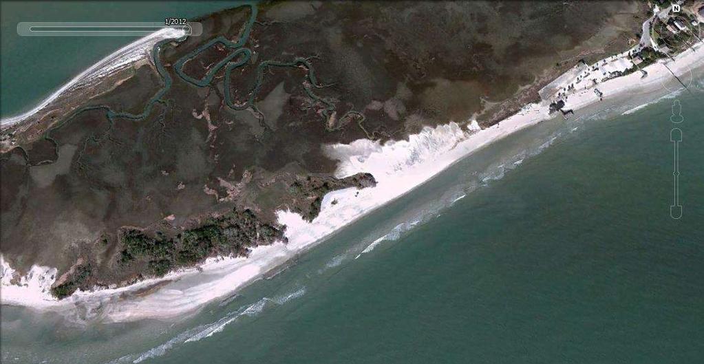


3 INTRODUCTION: FOLLY BEACH COUNTY PARK 3

4 FBCP RENOURISHMENT PROJECT June ,000 cubic yards Up to 500 ft berm 745 ft Terminal Groin Gravel Road $3.46M 65% sand 35% structure 4

5 DUNE MANAGEMENT PLAN (DMP) PURPOSE Restore a natural dune ecosystem Plan before act DMP: Flexible nature s dynamics & changing user needs Mitigate and adapt to future erosion and sea level rise challenges Informed decision making based on scientific data (long-term) 5
6 US ARMY CORPS OF ENGINEERS 6
7 EXISTING CONDITIONS


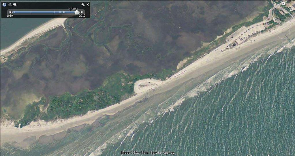
8 SEGMENT 1: ENTRANCE 3 Access Points: 1 Vehicle 2 Pedestrian #1 = Pelican Watch WALKOVER 8

9 SEGMENT 2: CENTRAL 4 Access Points: 1 Vehicle 3 Pedestrian


10 PORT-O-LET LOCATIONS SOUTHWEST Wind Direction NORTHEAST 10

11 SAND FENCING ORIENTATION Wind Direction 11

12 DOWNDRIFT CENTRAL 12


13 SEGMENT 3: DOWNDRIFT 1 Vehicle Access 13
14 MARSH SIDE 14
15 CCPRC GOALS Re-establish a natural dune ecosystem Adhere to DHEC-OCRM Permit G Retain nourished sand on beach side of road Mimic nature Locate dunes in long-term stable portion of backbeach Provide public access while building dunes year round Follow integrated plan for park management decisions 15

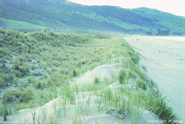
16 RE-ESTABLISH NATURAL DUNE ECOSYSTEM Objectives: Restore robust, vegetated dunes (short-term) Maritime forest (long-term) Attract native fauna with native flora Mimic natural land elevations Retain open space for shorebirds on marsh Limit high elevations nearby GOAL #1 16
 Plant creeping and scrub vegetation to stabilize marsh-side of road mimic adjacent areas. 17")
17 RE-ESTABLISH NATURAL DUNE ECOSYSTEM Recommendations: Plan to restore a different dune system than existed previously (modify your expectations) Allow overwash deposit to evolve naturally GOAL #1 Avoid predator enhancements: No sand fence or sea oats on marsh-side of road (limit elevations) Plant creeping and scrub vegetation to stabilize marsh-side of road mimic adjacent areas. 17
18 CCPRC GOALS Re-establish a natural dune ecosystem Adhere to DHEC-OCRM Permit G Retain nourished sand on beach side of road Mimic nature Locate dunes in long-term stable portion of backbeach Provide public access while building dunes year round Follow integrated plan for park management decisions 18

19 GOAL #2 ADHERE TO DHEC-OCRM PERMIT Objectives: Specific Condition #19: All planting must be designed to minimize impacts to sea turtles Specific Condition #20: New beach access locations must be approved by the Service and OCRM Specific Condition #21: Expanded or newly created beach access points must be restored to dune habitat within 3 months following project completion. Habitat restoration must consist of restoring dune topography and planting with appropriate native dune vegetation. Advance/proactive mitigation downdrift of the terminal groin 19

20 GOAL #2 ADHERE TO DHEC-OCRM PERMIT Recommendations: Limit continuous, shore-parallel, sand fencing to landward of future dune crest Engage DHEC OCRM and USF&WS staff in dune management meetings Restore and stabilize dune in downdrift segment 20
21 CCPRC GOALS Re-establish a natural dune ecosystem Adhere to DHEC-OCRM Permit G Retain nourished sand on beach side of road Mimic nature Locate dunes in long-term stable portion of backbeach Provide public access while building dunes year round Follow integrated plan for park management decisions 21
22 RETAIN SAND ON BEACH SIDE OF ROAD Objectives: Protect investment in new road with green infrastructure Limit parking lot maintenance Limit sand entering marsh & limit runoff from road to marsh GOAL #3 22
 GOAL")
23 RETAIN SAND ON BEACH SIDE OF ROAD Recommendations: Restore dune system into a continuous line of defense Locate dunes as close to road as possible Stabilize marsh-side of road with creeping and scrub vegetation (bacharius) GOAL #3 23
24 CCPRC GOALS Re-establish a natural dune ecosystem Adhere to DHEC-OCRM Permit G Retain nourished sand on beach side of road Mimic nature Locate dunes in long-term stable portion of backbeach Provide public access while building dunes year round Follow integrated plan for park management decisions 24

25 LOCATE DUNES IN STABLE PORTION OF BEACH Objectives: Create largest (primary) dunes as far landward as possible Provide at least 75 ft of beach area for public use Avoid dune erosion GOAL #4 25

26 LOCATE DUNES IN STABLE PORTION OF BEACH Recommendations: GOAL #4 Cite future toe of dune at least 100 ft landward of equilibrium shoreline Utilize planting and fencing design that becomes less aggressive toward the ocean 26
27 CCPRC GOALS Re-establish a natural dune ecosystem Adhere to DHEC-OCRM Permit G Retain nourished sand on beach side of road Mimic nature Locate dunes in long-term stable portion of backbeach Provide public access while building dunes year round Follow integrated plan for park management decisions 27
28 PROVIDE PUBLIC ACCESS & BUILD DUNES Objectives: Build dunes and provide access in peak summer season for beach users Build elevation inside access paths during off season, peak wind season Year-round dune building Minimize breaks in dune system that could funnel storm surge Keep users out of establishing dunes Provide vehicular access where necessary GOAL #5 28


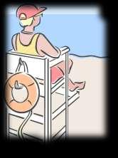
29 PROVIDE PUBLIC ACCESS & BUILD DUNES This Not This 29
30 GOAL #5 PROVIDE PUBLIC ACCESS & BUILD DUNES Recommendations: Minimize access points Angle/slant paths north-south Close some access paths in off season Install temporary sand fencing if possible Relocate port-o-lets to NE side of access paths Utilize continuous sand fencing to build dunes and control pedestrian traffic Along paths and at dune/parking area transition Limit continuous, shore-parallel, sand fencing to landward of future dune crest Compare post-project turtle nesting data with planned fence lines 30
31 PROVIDE PUBLIC ACCESS & BUILD DUNES Recommendations (cont.): Two vehicle access points at each end of park North vehicle access to be phased out South vehicle access wide enough for vehicles Including tilling equipment and bulldozers for future maintenance One vehicle access at south end to provide access around the terminal groin GOAL #5 31
32 CCPRC GOALS Re-establish a natural dune ecosystem Adhere to DHEC-OCRM Permit G Retain nourished sand on beach side of road Mimic nature Locate dunes in long-term stable portion of backbeach Provide public access while building dunes year round Follow integrated plan for park management decisions 32
33 GOAL #6 INTEGRATED PLAN FOR MANAGEMENT DECISIONS Objectives: Determine fate of maintenance material from new road (sand/gravel mixture) Minimalist beach access approach Paths & natural materials vs. boardwalks, platforms Minimize storm debris & maintenance Create Beach-side Public Use Area Volleyball courts and staging area for ecotours/events Potential for future facility citing Designate new location for lifeguard station Consolidate signage into educational displays Define needs of three park segments 33


34 EVIDENCE FOR MINIMALIST APPROACH Dunes overtaking wooden structures Maintenance issues 34
35 INTEGRATED PLAN FOR MANAGEMENT DECISIONS Recommendations: GOAL #6 Deposit sand/gravel from maintenance at south end vehicle access to create stable road pad Do not construct walkovers until dune system and user needs have been well established Utilize and properly maintain Mobimats for handicapped access Avoid wooden shower platforms that can be inundated with sand utilize natural gravel bases Relocate existing shower/platform farther landward Avoid platforms for Port-o-lets Smooth sand base and re-adjust if needed 35
 10 off bollards Erect temporary shade when needed GOAL #6")
36 INTEGRATED PLAN FOR MANAGEMENT DECISIONS Recommendations: Cite public use area in long-term stable location behind dunes = Adjacent to terminal groin Replicate natural dune/swale environment Stabilize use area with creeping vegetation if needed Limit sand loss into parking lot with creation of small dune (vegetation/fencing) 10 off bollards Erect temporary shade when needed GOAL #6 36

37 NATURAL DUNE/SWALE ENVIRONMENT 37

38 INTEGRATED PLAN FOR MANAGEMENT DECISIONS Recommendations: GOAL #6 Relocate existing lifeguard station Downsize width of first vehicle access to pedestrian Favor long-term stability and most hazardous swimming conditions = near terminal groin Install water line on beach side of road Plan for future infrastructure Potential utility corridor on marsh side Compile all anticipated signage Design educational displays in 1 year 38
39 CCPRC GOALS Re-establish a natural dune ecosystem Adhere to DHEC-OCRM Permit G Retain nourished sand on beach side of road Mimic nature Locate dunes in long-term stable portion of backbeach Provide public access while building dunes year round Follow integrated plan for park management decisions 39


40 EDUCATIONAL & REGULATORY SIGNAGE 40

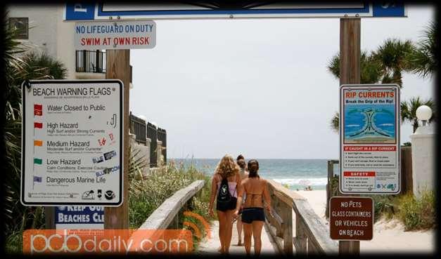
41 SIGN POLLUTION 41


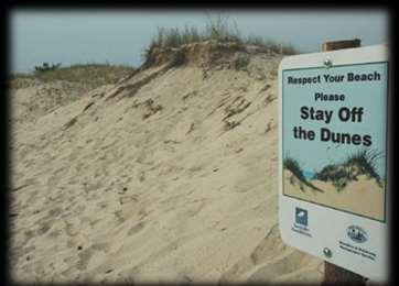
42 EXAMPLES: KEEP OFF DUNES SIGNS 42
43 OVERVIEW Public Use Area Toe of Dune (Keep Out) 43
")
44 DUNE MANAGEMENT PLAN: OVERVIEW Beach Access Sand Fencing Dune Vegetation Public Use Area Toe of Dune (Keep Out)
45 DUNE FENCING PLAN: TRAFFIC MGMT Beach Access Sand Fencing (continuous) Toe of Dune (Keep Out)
 Beach Access Sand Fencing Dune Vegetation Toe of Dune (Keep")
46 DUNE VEGETATION & FENCING PLAN: DETAIL Dune Vegetation: Sea oats (70%) Bitter panicum (30%) Beach Access Sand Fencing Dune Vegetation Toe of Dune (Keep Out) 46


47 DOWNDRIFT Sand Fencing Dune & Creeping Vegetation Toe of Dune (Keep Out) Dune Vegetation: Sea oats Bitter panicum Vines (ipomoea) 47

48 MARSH SIDE No Sand Fencing Creeping & Scrub Vegetation Keep Out Vegetation: Salt myrtle Marsh elder Vines (ipomoea) 48
49 NEW ACCESS SPECIFICATIONS Design for summer wind conditions Correspond with high-use season Based on today s on-the-ground conditions Relocate Port-o-lets to northeast side of paths Reorient path angle away from shore perpendicular Slanted paths Orient dune fencing shore perpendicular Water line on seaward side of road 49
50 RECOMMENDED IMPLEMENTATION PLAN Initial construction before May 1, 2014 Install water line on beach side of road to terminal groin Provide for temporary irrigation system for dunes Install sand fencing ASAP Install keep out post & ropes Plant all recommended vegetation (after water line) before October 15 or after March 15 Relocate port-o-lets and shower platform 50

51 RECOMMENDED IMPLEMENTATION PLAN Phase II Assess vegetation and fencing performance Adjust fencing patterns as needed Plant additional vegetation as needed Plant palms at beach access points Design & install educational signage Showers 51


52 DISCUSSION 52
Photo on 22 October 2016 Post Matthew. Nags Head Shoreline Management Committee Meeting
 Photo on 22 October 2016 Post Matthew Nags Head Shoreline Management Committee Meeting 18 January 2017 Project Schedule for the 2018 Re-Nourishment 2016 Month 1 May Initiate work (1) Define the ideal (target)
5a The past how people have affected New Zealand beaches. Exploring positive and negative impacts on dune systems
 5a The past how people have affected New Zealand beaches Exploring positive and negative impacts on dune systems Objectives for today Today we will look at the past How modified are New Zealand dune systems?
Appendix G Aquilla Lake Pool Rise Recreational Resources
 Appendix G Aquilla Lake Pool Rise Recreational Resources 1. INTRODUCTION The purpose of this appendix is to document the impacts of a 2.5 ft (Alternative A), 4.5 ft (Alternative B), and 6.5 ft. (Alternative
Appendix L Camille Cut Closure Desktop Analysis
 Appendix L Camille Cut Closure Desktop Analysis Camille Cut Closure A desk-top analysis of closure options MsCIP Multi-Agency Meeting January 13, 2011 US Army Corps of Engineers BUILDING STRONG Presentation
NEW HAVEN HARTFORD SPRINGFIELD RAIL PROGRAM
 NEW HAVEN HARTFORD SPRINGFIELD RAIL PROGRAM Hartford Rail Alternatives Analysis www.nhhsrail.com What Is This Study About? The Connecticut Department of Transportation (CTDOT) conducted an Alternatives
3.14 Parks and Community Facilities
 3.14 Parks and Community Facilities 3.14.1 Introduction This section identifies the park and community facility resources in the study area and examines the potential impacts that the proposed Expo Phase
WOLVERINE TO BHP JANSEN NEW TRANSMISSION LINE PROJECT FALL 2017
 WOLVERINE TO BHP JANSEN NEW TRANSMISSION LINE PROJECT FALL 2017 TODAY WE LL TALK ABOUT Our challenges and how we re meeting them Why we re building this project Our planning process and considerations
ANDERSON PROPERTY SITE ANALYSIS
 ANDERSON PROPERTY SITE ANALYSIS Introduction The Montgomery County Department of Transportation (MCDOT) initiated a feasibility study in the fall of 2012 to evaluate the need for transit service expansion
Corporate Engagement in Wetlands Restoration
 Corporate Engagement in Wetlands Restoration ConocoPhillips Coastal Wetlands A Model for Success Presentation Overview Property Overview CWPPRA Engagement ConocoPhillips/Ducks Unlimited Collaboration Restoration
A significant milestone..
 Cape Hatteras Access Preservation Alliance Post Office Box 1355 Buxton, North Carolina 27920 March 14, 2017 A significant milestone.. On January 20, 2017 the National Park Service (NPS) implemented a new
You Want Me to Pay for What?
 Using Tax Revenue to Measure the Benefits You Want Me to Pay for What? of Publicly-Funded Shore Protection Projects Program for the Study of Developed Shorelines (PSDS): Applied, interdisciplinary academic
City of Peachtree City
 City of Peachtree City Lake Peachtree Spillway Replacement City Council Update September 15, 2016 Project Team Integrated Science & Engineering 1 Spillway Alternatives Analysis Spillway Alternatives Evaluated
Location Concept Plan Amendment Recommendation Approved 2011 Concept Plan
 Valley Line West LRT Concept Plan Recommended Amendments Lewis Farms LRT Terminus Site Location Concept Plan Amendment Recommendation Approved 2011 Concept Plan Lewis Farms LRT terminus site, 87 Avenue/West
WELCOME Open House on Parking
 WELCOME Open House on Parking Tonight we re presenting our policy responses for your input on how to best manage our public parking. Parking is a shared community resource. To best serve everyone in our
Nearshore Rock Exposure at Patrick Air Force Base, Florida
 Kevin R. Bodge, PhD, P.E. Steven Howard, P.E. Will Reilly, P.E. olsen associates, inc. jacksonville, florida Nearshore Rock Exposure at Patrick Air Force Base, Florida Patrick Air Force Base, FL 45 th
DRAFT. Appendix A: Final Report, Singleton Swash Current Velocities and Discharge Rates, January 2008
 DRAFT Appendix A: Final Report, Singleton Swash Current Velocities and Discharge Rates, January 2008 26 SINGLETON SWASH CURRENT VELOCITIES AND DISCHARGE RATES JANUARY 2008 FINAL REPORT SUBMITTED TO: US
Kendall Drive Premium Transit PD&E Study Project Kick-Off Meeting SR 94/Kendall Drive/SW 88 Street Project Development and Environment (PD&E) Study
 Study") Florida Department of Transportation District Six Kendall Drive Premium Transit PD&E Study Project Kick-Off Meeting SR 94/Kendall Drive/SW 88 Street Project Development and Environment (PD&E) Study What
Florida Department of Transportation District Six Kendall Drive Premium Transit PD&E Study Project Kick-Off Meeting SR 94/Kendall Drive/SW 88 Street Project Development and Environment (PD&E) Study What
PARKING OCCUPANCY IN WINDSOR CENTER
 PARKING OCCUPANCY IN WINDSOR CENTER TOWN OF WINDSOR, CONNECTICUT REPORT JUNE 2017 CONTENTS Background... 3 Other Relevant Data... 3 Parking Survey Design... 6 Parking Supply Inventory... 6 Parking Demand
Mayor and Assembly Briefings
 March 6 7, 2013 September 1, 2011 Mayor and Assembly Briefings Port of Anchorage Intermodal Expansion Project Concept Design Study 1 Briefing Outline Recap the Design Charrette Overview of the 3 Concept
There will be up to Day permits active at any time and 3000 annual permits available.
 0066645 Cape Cod National Seashore Oversand Beach Driving From the Website below: http://www.nps.gov/caco/planyourvisit/oversand.htm ORV Annual Reports and Related Documents The off-road driving corridor
IN THE SUPERIOR COURT OF FULTON COUNTY STATE OF GEORGIA
 IN THE SUPERIOR COURT OF FULTON COUNTY STATE OF GEORGIA ONE HUNDRED MILES, ) Petitioner, ) ) v. ) ) Civil Action No: SHORE PROTECTION COMMITTEE, ) Respondent, ) ) and ) ) SEA ISLAND ACQUISITION, LLC )
Develop ground transportation improvements to make the Airport a multi-modal regional
 Project Overview TRANSPORTATION IMPROVEMENTS WHAT ARE THE PROJECT GOALS? Transportation transportation hub. Develop ground transportation improvements to make the Airport a multi-modal regional Land Use
Confederation Line West Queensway Terrace North. May 27, 2017
 Confederation Line West Queensway Terrace North May 27, 2017 Agenda Background Lincoln Fields Station Concept LRT alignment, southwest of Lincoln Fields to Queensway, including: Pedestrian bridge replacement
Mississauga Bus Rapid Transit Preliminary Design Project
 Mississauga Bus Rapid Transit Preliminary Design Project PUBLIC INFORMATION CENTRE OCTOBER 2008 WELCOME The Mississauga Bus Rapid Transit (BRT) Project Thank you for attending this Public Information Centre.
REASONABLE FURTHER PROGRESS REPORT FOR THE MONO BASIN PM-10 STATE IMPLEMENTATION PLAN
 REASONABLE FURTHER PROGRESS REPORT FOR THE MONO BASIN PM-10 STATE IMPLEMENTATION PLAN September 2001 This document provides a progress report on air quality trends in the Mono Basin federal PM-10 1 nonattainment
CHAPTER 2 ZONING AND DEVELOPMENT
 2.200 GENERAL DEVELOPMENT STANDARDS CHAPTER 2 ZONING AND DEVELOPMENT Section 2.201 GENERAL PROVISIONS... 2.2-1 Section 2.202 FENCES AND VISIONS CLEARANCE... 2.2-2 2.202.01 Fences... 2.2-2 2.202.02 Vision
TRAFFIC PARKING ANALYSIS
 TRAFFIC PARKING ANALYSIS NAPA FLEA MARKET COUNTY OF NAPA Prepared for: Tom Harding Napa-Vallejo Flea Market 33 Kelly Road American Canyon, CA 9453 Prepared by: 166 Olympic Boulevard, Suite 21 Walnut Creek,
Husky Stadium: TMP Modernization Project
 Husky Stadium: TMP Modernization Project 1 Husky Stadium: TMP History 2 Husky Stadium TMP History 1986-1987 Husky Stadium adds the north upper deck. City of Seattle and UW agree on a plan (TMP) to mitigate
PEACHTREE CORRIDOR PARTNERSHIP. Current Status & Next Steps
 PEACHTREE CORRIDOR PARTNERSHIP Current Status & Next Steps PEACHTREE CORRIDOR PARTNERSHIP Why Peachtree? Why Now? I. THE CONTEXT High Level View of Phasing Discussion Potential Ridership Segment 3 Ease
Technical Memorandum. To: From: Date: October 14 th, 2018 Project #: 1302 Project Name: Subject: Distribution:
 Technical Memorandum To: Tom Hanrahan Jeff Sharp From: Date: October 14 th, 2018 Project #: 1302 Project Name: Subject: Distribution: Barrie Lockhart Road LP Conformity Review Scott Young Sorbara Group
LOWER ANDRUS ISLAND SPECIAL PLANNING AREA
 LOWER ANDRUS ISLAND SPECIAL PLANNING AREA 505-10. INTENT. It is the intent of the Board of Supervisors in adopting this Special Planning Area to permit the additional and logical development of the unique
Draft. Cape Hatteras National Seashore. Cape Hatteras National Seashore. Off-Road Vehicle Management Plan / Environmental Impact Statement
 Cape Hatteras National Seashore North Carolina National Park Service U.S. Department of the Interior Draft Cape Hatteras National Seashore Off-Road Vehicle Management Plan / Environmental Impact Statement
Exposition Light Rail Transit Project
 Exposition Light Rail Transit Project Project Status Update Meeting West End Corridor Segment C Culver City Senior Center May 27, 2010 Phase 1 Project Description 8.6 mile corridor from Downtown Los Angeles
Link LRT: Maintenance Bases, Vehicles and Operations for ST2 Expansion
 Project Number SYS-LRT Subareas All Primary Mode Impacted Link Facility Type Link Service Version Number 4.0 Date Last Modified 7/24/2008 Project Locator Map Short Project Description Construct new light
Table Existing Traffic Conditions for Arterial Segments along Construction Access Route. Daily
 5.8 TRAFFIC, ACCESS, AND CIRCULATION This section describes existing traffic conditions in the project area; summarizes applicable regulations; and analyzes the potential traffic, access, and circulation
Big Easy RV & Boat Storage A Green Energy Project Jana Lane Wildomar, California
 Big Easy RV & Boat Storage A Green Energy Project 36215 Jana Lane Wildomar, California 1 PROJECT OVERVIEW Project Description The construction and operation of a solar generation facility consisting of
Joint Con Edison LIPA Offshore Wind Power Integration Project Feasibility Assessment
 Joint Con Edison LIPA Offshore Wind Power Integration Project Feasibility Assessment For NPCC Governmental / Regulatory Affairs Advisory Group May 21 st, 2009 ON IT Executive Summary Engineers from Con
Corridor Sketch Summary
 Corridor Sketch Summary SR 241: I-82 Jct (Sunnyside) to SR 24 Jct Corridor Highway No. 241 Mileposts: 7.53 to 25.21 Length: 17.65 miles Corridor Description The seventeen and one-half mile corridor begins
San Rafael Transit Center. Update. Golden Gate Bridge, Highway & Transportation District Transportation Committee of the Board of Directors
 Transportation Committee November 17, 2016 Agenda Item No. 5, Update on the San Rafael Transit Center Relocation San Rafael Transit Center Relocation Study Update 11/17/16 Golden Gate Bridge, Highway &
Waco Rapid Transit Corridor (RTC) Feasibility Study
 Feasibility Study") Waco Rapid Transit Corridor (RTC) Feasibility Study Chris Evilia, Director of Waco Metropolitan Planning Organization Allen Hunter, General Manager Waco Transit System Jimi Mitchell, Project Manager AECOM
Waco Rapid Transit Corridor (RTC) Feasibility Study Chris Evilia, Director of Waco Metropolitan Planning Organization Allen Hunter, General Manager Waco Transit System Jimi Mitchell, Project Manager AECOM
FREQUENTLY ASKED QUESTIONS
 THE PROJECT Last updated on 9/8/16 FREQUENTLY ASKED QUESTIONS What s happening on Highway 169? The Minnesota Department of Transportation (MnDOT) is planning to rebuild and repair the infrastructure on
Lake Tahoe Basin Management Unit; CA; Meeks Bay Restoration Project. Notice of intent to prepare an environmental impact statement.
 This document is scheduled to be published in the Federal Register on 09/11/2018 and available online at https://federalregister.gov/d/2018-19682, and on govinfo.gov [3411-15- P] DEPARTMENT OF AGRICULTURE
Capital Needs Assessment Riders Advisory Council July2, 2008
 Capital Needs Assessment 2011-2020 Riders Advisory Council July2, 2008 1 Outline I. Capital Improvement Plan History II. Capital Improvement Plan Update III. Capital Needs Assessment State of Good Repair
INTERIM CONSTRUCTION RECORD REPORT TAILINGS POND 4 STAGE 3 RAISE
 #1640 1188 West Georgia St. Vancouver, BC V6E 4A2 Ph: (604) 684-5300 Fax: (604) 684-2992 INTERIM CONSTRUCTION RECORD REPORT TAILINGS POND 4 STAGE 3 RAISE OCTOBER 2009 NORTH AMERICAN TUNGSTEN CORPORATION
Cleary Rd and Belvedere Rd West Palm Beach, FL Great Centralized PB County location. Easy access to I-95 and Fl. Turnpike
 and Belvedere Rd For more information contact: John Hoecker, CCIM, CPM, CSM President 5613668424 John@JupiterRealtyCompany.com Great Centralized PB County location. Easy access to I-95 and Fl. Turnpike
SOUTHERN GATEWAY. Transportation and Trinity River Project Committee 11 May 2015
 SOUTHERN GATEWAY Transportation and Trinity River Project Committee 11 May 2015 Southern Gateway Project History Began in 2001 as a Major Investment Study [ MIS ], Schematic, and Environmental Assessment
FREQUENTLY ASKED QUESTIONS
 THE PROJECT Last updated on 2/19/16 FREQUENTLY ASKED QUESTIONS What s happening on Highway 169? The Minnesota Department of Transportation (MnDOT) is planning to rebuild and repair the infrastructure on
STH 60 Northern Reliever Route Feasibility Study Report
 #233087 v3 STH 60 Northern Reliever Route Feasibility Study Report Washington County Public Works Committee Meeting September 28, 2016 1 STH 60 Northern Reliever Route Feasibility Study Hartford Area Development
California s Emission Reduction Plan for Ports and International Goods Movement
 California s Emission Reduction Plan for Ports and International Goods Movement Alternative Maritime Power Conference Los Angeles Harbor Hotel April 24, 2006 California Environmental Protection Agency
New Franchise Agreement: Recyclables, Organics, and Waste. Town of Truckee Town Council Meeting July 25, 2017
 New Franchise Agreement: Recyclables, Organics, and Waste Town of Truckee Town Council Meeting July 25, 2017 Agenda Overview of Process, Context Review Regulatory Drivers Review of Current Services Potential
Maine Medical Center Campus-Wide Parking Study
 Overview Maine Medical Center (MMC) retained VHB to conduct a campus-wide parking study that includes an analysis of demand and supply for patient, visitor, and employee parking on MMC s Bramhall Campus.
Evaluating Wind vs. Water
 Evaluating Wind vs. Water By Jeffery H. Warren, Ph.D., P.E., CSP In hurricane situations, wind or water or both may cause damage. Determining the cause of the damage is critical in the claim settlement.
/ Planning and Zoning Staff Report Lonestar Land, LLC. - Rezone, RZ
 / Planning and Zoning Staff Report Lonestar Land, LLC. - Rezone, RZ2018-0019 Hearing Date: October 18, 2018 Development Services Department Applicant: Lonestar Land, LLC. Representative: Lance Warnick
THE CORPORATION OF THE MUNICIPALITY OF KINCARDINE BY-LAW NO
 THE CORPORATION OF THE MUNICIPALITY OF KINCARDINE BY-LAW NO. 2016-016 BEING A BY-LAW TO PERMIT AND CONTROL THE OPERATION OF OFF-ROAD VEHICLES ON HIGHWAYS UNDER THE JURISDICTION OF THE CORPORATION OF THE
Engineering Report: Shasta-Trinity National Forest. South Fork Management Unit. Analysis of. National Forest System Road 30N44
 Engineering Report: Shasta-Trinity National Forest South Fork Management Unit Analysis of National Forest System Road 30N44 (milepost 0.00 to 0.40) for Motorized Mixed Use Designation Forest: Shasta-Trinity
Chapter 11 Route Window NE10 Gidea Park station. Transport for London
 Chapter 11 Route Window NE10 Gidea Park station Transport GIDEA PARK STATION 11 Route Window NE10 Gidea Park station Transport Introduction 11.1 The construction activities in this route window are associated
Information Meeting Transfer Station Options. September 30, 2014
 Information Meeting Transfer Station Options September 30, 2014 Outline of Presentation Why we are looking at changes Background on current Transfer Station Options that were considered need, function
Winnipeg Transit Bus Maintenance Garage Expansion Project
 Winnipeg Transit Bus Maintenance Garage Expansion Project Thank you for your interest in this project! We invite you to review information on the display boards, meet project team members to share your
However, due to the location, all garage parkers will need to continue to use the South end garage for entrance and exit.
 We apologize for any inconvenience that this construction may cause and appreciate your patience while we work hard to improve The Crescent for our customers. Effective Tuesday, July 28 Shoring for the
W&OD TRAIL BRIDGE OVER LEE HIGHWAY I-66 EASTBOUND WIDENING INSIDE THE BELTWAY FROM THE DULLES CONNECTOR ROAD (ROUTE 267) TO FAIRFAX DRIVE (ROUTE 237)
 TO FAIRFAX DRIVE (ROUTE 237)") W&OD TRAIL BRIDGE OVER LEE HIGHWAY A COMPONENT OF THE I-66 EASTBOUND WIDENING INSIDE THE BELTWAY FROM THE DULLES CONNECTOR ROAD (ROUTE 267) TO FAIRFAX DRIVE (ROUTE 237) October 11, 2018 Bill Cuttler, PE
W&OD TRAIL BRIDGE OVER LEE HIGHWAY A COMPONENT OF THE I-66 EASTBOUND WIDENING INSIDE THE BELTWAY FROM THE DULLES CONNECTOR ROAD (ROUTE 267) TO FAIRFAX DRIVE (ROUTE 237) October 11, 2018 Bill Cuttler, PE
Overview of Electricity Trade Agreement between Québec and Ontario. May 10, 2017 For Information Purposes Only
 Overview of Electricity Trade Agreement between Québec and Ontario May 10, 2017 For Information Purposes Only Purpose To provide an overview of the electricity trade agreement between the Independent Electricity
On June 11, 2012, the Park Board approved the installation of three electric vehicle charging stations along Beach Avenue.
 January 8, 2017 TO: Park Board Chair and Commissioners FROM: General Manager Vancouver Board of Parks and Recreation SUBJECT: Electric Vehicle Charging Stations New Park Board Locations RECOMMENDATION
Northern Indiana Commuter Transportation District VENDOR OPEN HOUSE APRIL 17, 2019
 Northern Indiana Commuter Transportation District VENDOR OPEN HOUSE APRIL 17, 2019 VENDOR OPEN HOUSE AGENDA Welcome and Introductions Safety Briefing NICTD Website and Plan Room Upcoming Projects Disadvantaged
Cushman & Adams Substations MOU March 28, Cushman & Adams Substations April, 1937
 Cushman & Adams Substations MOU March 28, 2018 Cushman & Adams Substations April, 1937 Joint Staff Task Force Terry Coggins, Tacoma Power Ward Groves, Legal Jennifer Hines, Real Property Services Peter
One-Hundred-Year Storm Elevation Requirements for Habitable Structures Located Seaward of a Coastal Construction Control Line
 One-Hundred-Year Elevation Requirements for Habitable Structures Located Seaward of a Coastal Construction Control Line ELEVATION CERTIFICATE AND INSTRUCTIONS Prepared by: Florida Department of Environmental
Green Line LRT: Beltline Segment Update April 19, 2017
 Green Line LRT: Beltline Segment Update April 19, 2017 Quick Facts On April 11, 2017, City Council approved Administration s recommendation for the Green Line to be underground in the Beltline from 2 Street
Analysis of Management Efforts at North Beach Park Dune, Michigan
 Analysis of Management Efforts at North Beach Park Dune, Michigan by Ann Parkin, Catherine Hilbrands, Joanne Hulst, Elizabeth Stranzenbach, and Sam Vannette FYRES: Dunes Research Report #2 May 2012 Department
Environmentally Compliant Range Designs at Ft. Hood, TX
 Environmentally Compliant Range Designs at Ft. Hood, TX Ms. Brooke E. Conway Mr. Joseph Bush 22 March 2006 Brooke E. Conway / SFIM-AEC-ATT / 410-436-6850 / brooke.conway@us.army.mil 1 of 28 031400RMAR2006
A Salt Marsh Advancement Zone Assessment of Greenwich, Connecticut
 A Salt Marsh Advancement Zone Assessment of Greenwich, Connecticut Front cover image: Open space and unprotected parcels critical to the conservation of marsh advancement corridors in Greenwich; from the
NPCC Natural Gas Disruption Risk Assessment Background. Summer 2017
 Background Reliance on natural gas to produce electricity in Northeast Power Coordinating Council (NPCC) Region has been increasing since 2000. The disruption of natural gas pipeline transportation capability
Energy Technical Memorandum
 Southeast Extension Project Lincoln Station to RidgeGate Parkway Prepared for: Federal Transit Administration Prepared by: Denver Regional Transportation District May 2014 Table of Contents Page No. Chapter
Proposal for September 2006 Start of Commuter Rail from Lovejoy on the Macon Line to Atlanta
 Proposal for September 2006 Start of Commuter Rail from Lovejoy on the Macon Line to Atlanta Overview Commuter rail service between Lovejoy and Atlanta is ready for implementation: $87.08 Million is in
Purpose: General Provisions:
 10-19-1 Purpose: The purpose of off-street parking requirements is to promote traffic/pedestrian safety and efficiency and to minimize hard surfaced areas to reduce storm water run-off and visual impacts
Downtown Parking/Wayfinding Study. Review of Recommendations to City Council: January 16, 2018
 Downtown Parking/Wayfinding Study Review of Recommendations to City Council: January 16, 2018 Tonight s Focus Objectives & Timeline Recap Study Findings Present Staff Recommendations 2018 Action items
Memorandum October 5, 2017
 614 Magnolia Avenue Ocean Springs, Mississippi 39564 228.818.9626 Memorandum October 5, 2017 To: Gary Miller, U.S. Environmental Protection Agency From: David Keith, John Laplante, Matt Henderson, and
appendix 4: Parking Management Study, Phase II
 appendix 4: Parking Management Study, Phase II A4-1 A4-2 Eastlake Parking Management Study Final Phase 2 Report Future Parking Demand & Supply January 6, 2017 Submitted by Denver Corp Center III 7900 E.
The Hinkley Point C Project
 The Hinkley Point C Project David Eccles Head of Communications - Hinkley Point C 1 Energy plc. All rights Reserved Hinkley Point C: Project Overview Low carbon energy for around 5 million homes. Helps
FINAL. Sound Transit Long-Range Plan Update. Issue Paper S.1: Tacoma Link Integration with Central Link. Prepared for: Sound Transit
 Sound Transit Long-Range Plan Update Issue Paper S.1: Tacoma Link Integration with Central Link Prepared for: Sound Transit Prepared by: Quade & Douglas, Inc. FINAL March 2005 Foreword This issue paper
BOARD OF SUPERVISORS BUSINESS MEETING ACTION ITEM. Design Endorsement for Sterling Boulevard Extension
 Date of Meeting: July 20, 2017 # 6 BOARD OF SUPERVISORS BUSINESS MEETING ACTION ITEM SUBJECT: ELECTION DISTRICT: CRITICAL ACTION DATE: STAFF CONTACTS: Design Endorsement for Sterling Boulevard Extension
King County Metro. Columbia Street Transit Priority Improvements Alternative Analysis. Downtown Southend Transit Study. May 2014.
 King County Metro Columbia Street Transit Priority Improvements Alternative Analysis Downtown Southend Transit Study May 2014 Parametrix Table of Contents Introduction... 1 Methodology... 1 Study Area...
Public Works Department, Capital Improvement Program Project Tracking
 Community Facilities Name CF-01 Eastshore State Park/Powell Street Bioswale Seeking grant funding. TT CF-02 South Bayfront Bridge and Horton Landing Park CF-03 / - 04 Transit Center Updated plans are being
RECOMMENDATION PAPER TO THE DULLES CORRIDOR COMMITTEE
 DULLES RAIL RECOMMENDATION PAPER TO THE DULLES CORRIDOR COMMITTEE ANALYSIS OF ALTERNATIVE AIRPORT ALIGNMENTS FOR METRORAIL AT WASHINGTON DULLES INTERNATIONAL AIRPORT MARCH 2011 PURPOSE This paper presents
Redefining Mobility Ready or not: Autonomous and connected vehicle planning and policy, now and in the future
 Redefining Mobility Ready or not: Autonomous and connected vehicle planning and policy, now and in the future Randy Iwasaki November 30, 2017 WHO WE ARE The Contra Costa Transportation Authority (CCTA)
COASTAL MARSHLANDS PROTECTION ACT STAFF S FINDINGS & RECOMMENDATIONS. August 11, 2017
 COASTAL MARSHLANDS PROTECTION ACT STAFF S FINDINGS & RECOMMENDATIONS August 11, 2017 TO: FROM: APPLICANT: AGENT: Coastal Marshlands Protection Committee: Commissioner Mark Williams, Chairman Mr. Henry
LOW VOLUME ROADS The Backbone of Your County Road System
 2018 Far West County Judges & Commissioners Assn. Conference September 11-14, 2018 LOW VOLUME ROADS The Backbone of Your County Road System County Commissioners continue to face ever-increasing challenges
Terminal Alternatives
 Chapter 5 Terminal Alternatives Missoula International Airport Master Plan Update Prepared for Missoula County Airport Authority OCTOBER 2008 Contents Section Page 5 Terminal Alternatives...5-1 5.1 Terminal
Transportation Sustainability Program
 Transportation Sustainability Program Photo: Sergio Ruiz San Francisco 2016 Roads and public transit nearing capacity Increase in cycling and walking despite less than ideal conditions 2 San Francisco
Mercer Island Center for the Arts Parking Management Plan
 Parking Stalls Mercer Island Center for the Arts Parking Management Plan June 15, 2016 This Parking Management Plan (P) covers all tenants at the Mercer Island Center for the Arts (MICA) campus, including
Quonset Business Park
 Quonset Business Park September 28, 2010 Katherine Trapani Planning Manager Quonset Development Corporation Quonset Business Park 3,160 Total Acres 168 Companies 8,842 Jobs QDC Input into URI Study Water
Oregon s EV Charging Network National Association of State Energy Officials June 12, 2012
 Oregon s EV Charging Network National Association of State Energy Officials June 12, 2012 Art James Oregon Department of Transportation Office of Innovative Partnerships 1 OREGON In Perspective Population
Folly Beach Planning Commission Joint Work Session/ Regular Meeting
 September 11, 2017 Folly Beach Planning Commission Joint Work Session/ Regular Meeting 5:30 PM JOINT WORKESSION WITH COUNCIL 7:00 PM REGULAR MEETING ----------------------------------------------------------------------------------------------------
Planning Commission Staff Report Ordinance Amendment Hearing Date: November 14, 2018
 Planning Commission Staff Report Ordinance Amendment Hearing Date: November 14, 2018 ITEM # 1* Western Community Crossroads LC requests an Ordinance Text amendment to Section 14.34.350 Recreational Vehicle
Final General Reevaluation Report and Final Environmental Impact Statement. Hurricane Protection and Beach Erosion Control
 Final General Reevaluation Report and Final Environmental Impact Statement on Hurricane Protection and Beach Erosion Control WEST ONSLOW BEACH AND NEW RIVER INLET (TOPSAIL BEACH), NORTH CAROLINA Appendix
BUS STOP DESIGN & PLANNING GUIDE
 BUS STOP DESIGN & PLANNING GUIDE Prepared by the Operations and Planning Departments 2011 PURPOSE OF GUIDE The design of passenger waiting areas plays a significant role in a person s decision of whether
Connected Vehicle and Autonomous Vehicle (CV/AV) Mobility and Technology
 Mobility and Technology") Connected Vehicle and Autonomous Vehicle (CV/AV) Mobility and Technology Randy Iwasaki Executive Director Contra Costa Transportation Authority May13, 2016 WHO WE ARE The Contra Costa Transportation Authority
Connected Vehicle and Autonomous Vehicle (CV/AV) Mobility and Technology Randy Iwasaki Executive Director Contra Costa Transportation Authority May13, 2016 WHO WE ARE The Contra Costa Transportation Authority
Greater Cleveland Regional Transit Authority. Bus Stop Design Guidelines
 Greater Cleveland Regional Transit Authority Bus Stop Design Guidelines Contents Purpose... I Bus Stop Design & Location... 1 Bus Stop Planning... 1 Bus Stop Safety & Consolidation... 1 As Needed Basis...
THE WAY WE MOVE LRT FOR EVERYONE
 THE WAY WE MOVE LRT FOR EVERYONE 2 LRT for Everyone LRT FOR EVERYONE Light rail is about more than transit; it s about transforming Edmonton. As the city grows, so do its transportation needs. LRT is an
JCP&L Verbatim Response to Middletown Township s Questions
 JCP&L Verbatim Response to Middletown Township s Questions Township officials sent 13 questions about the proposed Monmouth County Reliability Project to JCP&L on June 10 th. JCP&L provided direct responses
TRAFFIC IMPACT ANALYSIS. for MILTON SQUARE
 TRAFFIC IMPACT ANALYSIS for MILTON SQUARE US Route 7 Milton, Vermont March 5, 2008 LAMOUREUX & DICKINSON 14 Morse Drive Essex Junction, Vermont 05452 (802) 878-4450 Traffic Impact Assessment EXECUTIVE
DR SE WAY SOMERSIDE. C-N Neighborhood Commercial Site. R-LD - Development in accordance. Fully Landscaped Park/ Playground.
 LAND & BUSINESS SUPPORT DEPT Southlands Phase 6A Plan 01231 City of Medicine Hat Land & Business Support Ph (03) 52-1 Fax (03) 502-055 land_properties@medicinehat.ca updated August 20, 201 SOMERSET BAY