COMPREHENSIVE DOWNTOWN PARKING STUDY
|
|
|
- Gladys Lynch
- 5 years ago
- Views:
Transcription

1 COMPREHENSIVE DOWNTOWN PARKING STUDY, MA December 2014
2
3 Table of Contents 1 Executive Summary... 1 Background... 1 Study Goals... 2 Study Process... 2 Key Findings... 3 Strategies and Recommendations Introduction... 7 Study Purpose... 7 About The Report... 8 Study Area... 8 Related Studies Parking Inventory Parking Regulations Parking Utilization and Turnover Weekday Parking Utilization Weekday Spatial Analysis Weekend Parking Utilization Weekend Spatial Analysis Parking Turnover Public Process Public Kick-off Workshops Online Survey Stakeholder Interviews Public Charrette Land Use Analysis About Land Use and Parking Ratios Activity Subareas West Node East Node North Node Zoning Code Review Overview Parking Provision Parking Design Related Elements Strategies and Recommendations Add Parking Supply Add Availability in Key Areas Add Information/Clarity Add Access Add Coordination Nelson\Nygaard Consulting Associates Inc. i
4 Table of Figures Page Figure 1 Downtown Hudson Parking Recommendations... 6 Figure 2 Downtown Hudson Study Area... 9 Figure 3 Parking Inventory Figure 4 On-Street Parking Regulations Figure 5 Off-Street Parking Regulations Figure 6 Parking Supply and Regulations Figure 7 Parking Utilization - Study Area (THURSDAY) Figure 8 Parking Utilization Off-Street vs. On-Street (THURSDAY) Figure 9 Parking Utilization Restricted-Use vs. Publicly-Accessible (THURSDAY) Figure 10 Parking Utilization Discrete Areas (THURSDAY) Figure 11 Parking Utilization - Thursday 8:00 am Figure 12 Parking Utilization Thursday 10:00 am Figure 13 Parking Utilization Thursday 12:00 pm Figure 14 Parking Utilization Thursday 2:00 pm Figure 15 Parking Utilization Thursday 4:00 pm Figure 16 Parking Utilization Thursday 6:00 pm Figure 17 Parking Utilization Thursday 8:00 pm Figure 18 Parking utilization for the entire study area (SATURDAY) Figure 19 Parking Utilization Off-Street vs. On-Street (SATURDAY) Figure 20 Parking Utilization Restricted-Use vs. Publicly-Accessible (SATURDAY) Figure 21 Parking Utilization Discrete Areas (SATURDAY) Figure 22 Parking Utilization Saturday 10:00 am Figure 23 Parking Utilization Saturday 12:00 pm Figure 24 Parking Utilization Saturday 2:00 pm Figure 25 Parking Utilization Saturday 4:00 pm Figure 26 Parking Utilization Saturday 6:00 pm Figure 27 Location of Cars that Stay Longer than Two Hours Figure 28 Location of Cars that Park All Day Figure 29 Public Kick-Off Workshops: Community Map Mark-Ups Figure 30 Summarized Public Comments on Issues and Opportunities Figure 31 Why do you come to Downtown Hudson? Figure 32 Reasons People Visit Downtown Hudson Figure 33 Reasons People Do NOT Visit Downtown Hudson Figure 34 Where Are People Parking in Downtown Hudson? Figure 35 Where Do Customers Park? Figure 36 Where Do Employees Park? Figure 37 How Far Did You Park From Your Destination? Figure 38 How Far Are You Willing to Walk From Parking to Your Destination? Figure 39 How Long Does It Take For You To Find Parking? (Employees Only) Figure 40 How Long Does It Take For You To Find Parking? (Customers Only) Figure 41 Have You Ever Failed To Find Parking In Downtown Hudson? (Customers Only) Figure 43 Charrette Mapping and Walking Tour Nelson\Nygaard Consulting Associates Inc. ii
5 Figure 42 Parking Charrette Schedule Figure 44 Hudson Land Use Subarea/Node Analysis Zones Figure 45 Existing Land Use in West Node Figure 46 West Node Utilization Figure 47 West Node Off-street vs. On-street Utilization Figure 48 Existing Unshared Demand- West Node Figure 49 Existing Shared Demand- West Node Figure 50 Existing Shared Parking with Observed Parking Demand Figure 51 Immediate Build Out- Unshared Demand West Node Figure 52 Immediate Build Out- Shared Demand West Node Figure 53 Full Build Out - Unshared Demand West Node Figure 54 Full Build Out- Shared Demand West Node Figure 55 Existing Land Use in East Node Figure 56 East Node Utilization Figure 57 East Node Off-street vs. On-street Utilization Figure 58 Unshared Parking Demand- East Node Figure 59 Existing Shared Demand- East Node Figure 60 Existing Shared Demand- East Node with Observed Utilization Figure 61 Immediate Build Out- Unshared Demand East Node Figure 62 Immediate Build Out- Shared Demand-East Node Figure 63 Full Build Out- Unshared Demand East node Figure 64 Full Build Out- Shared Demand East Node Figure 65 Existing Land Use in North Node Figure 66 North Node Utilization Figure 67 North Node utilization Off-street vs. On-street Utilization Figure 68 Existing Unshared Demand- North Node Figure 69 Existing Shared Demand- North Node Figure 70 Existing Shared Demand with Utilization North Node Figure 71 Immediate Build Out - Unshared Demand North Node Figure 72 Immediate Build Out- Shared Demand North Node Figure 73 Future Build Out- Unshared Demand North Node Figure 74 Future Build Out- Shared Demand North Node Figure 75 Zoning Districts and Overlays in Downtown Hudson Figure 76 Parking Minimum and Maximum Requirements under Hudson s Zoning Bylaw Figure 77 Shared Parking Under Hudson s Zoning Bylaw Figure 78 Parking In-Lieu Fee Regulation under Hudson s Zoning Bylaw Figure 79 Dimensional Requirements under Hudson s Zoning Bylaw Figure 80 Curb Cut Guidance under Hudson s Zoning Bylaw Figure 81 Car Sharing Regulations under Hudson s Zoning Bylaw Figure 82 Unbundling of Parking Cost Regulations under Hudson s Zoning Bylaw Figure 83 Bicycle Parking Regulation under Hudson s Zoning Bylaw Figure 84 Transportation Demand Management Measures under Hudson s Zoning Bylaw Figure 85 Summary of Future Recommendations Figure 86 Opportunity for Additional On-Street Parking Figure 87 Overview of New Parking Locations on South Street and Adjoining Side Streets Nelson\Nygaard Consulting Associates Inc. iii
6 Figure 88 Observed Parking on South Street (Southerly Side) Figure 89 South Street: Existing ROW at Market Street Figure 90 South Street: Proposed ROW at Market Street Figure 91 South Street: Existing ROW at Horseshoe Pub Figure 92 South Street: Proposed ROW at Horseshoe Pub Figure 93 Add and Formalize Parking on Felton Street Figure 95 Felton Street: Proposed ROW at Main Street Figure 96 Felton Street: Existing ROW at Russell Street Figure 97 Felton Street: Proposed ROW at Russell Street Figure 98 South Street Lot: Existing Configuration (157 spaces) Figure 99 South Street Lot: Proposed Reconfiguration (176 spaces) Figure 100 Small Adjacent Lots on South Street: Existing Configuration Figure 101 Small Adjacent Lots on South Street: Proposed Figure 102 Avidia Lot: Existing Configuration Figure 103 Avidia Lot: Proposed Configuration Figure 104 Shared Parking Opportunities Figure 105 Parcels Under Consideration for Expanding Parking Supply Figure 106 Summary of Parcels for Purchase Consideration in Expanding Parking Supply Figure 107 Context and Analysis of Prospective Parcels for Parking Supply Expansion Figure 108 Price for Availability Figure 109 Existing Parking Supply and Pricing Figure 110 Proposed Parking Supply and Regulations Figure 111 Smart Meters Figure 112 Pay by License Plate Figure 113 Pay by Cell Figure 114 Locations of Parking Existing Signage and Specific Issues Figure 115 Existing Public Parking Signage Figure 116 Proposed Signage Improvements Figure 117 Inconsistent Formats of Parking Signage in Downtown Hudson Figure 118 Suggested Concept for Branding Public Lots Figure 119 Lot Branding System in Lansdale, PA Figure 120 Existing Alleyway to Public Parking Lot Figure 121 Proposed Alleyway Signage Figure 122 Inconsistency of Signage on Overnight Parking Regulations Figure 123 Salem Parking Map (parkinginsalem.com) Figure 124 Well-Maintained Pedestrian Alley Connects Main Street to South Street Parking Figure 125 Example Areas in Need of Pedestrian Improvements Figure 126 Curb Extensions Enhance Pedestrian Visibility and Safety Figure 127 Current and Future Trail Connections Figure 128 Existing Bike Parking Located in Grass and Behind Bushes Figure 129 Simple U-Racks (short-term bicycle parking) Figure 130 On-Street Biking Corrals are Visible Figure 131 Branded Bicycle Racks Figure 132 Covered Racks can Support Long-Term Bike Parking Needs Figure 133 Crosswalk Access Around Rotary Nelson\Nygaard Consulting Associates Inc. iv
7 Figure 134 Aerial View of Existing Rotary Figure 135 Rotary Redesign Concept Figure 136 Rotary Redesign Concept Figure 137 Parklets Can Help Create a Sense of Place in Downtown Nelson\Nygaard Consulting Associates Inc. v
8

9 1 EXECUTIVE SUMMARY BACKGROUND Hudson s recent and ongoing downtown investments have been working to revitalize a strong, historic, New England center. The brick-lined sidewalks, tree plantings, gaslight streetlamps, and the Assabet River Rail Trail on the edge of town have been some of the reasons for the new business activity on and off Main Street. The Town s economic development efforts have been complemented by a strong Chamber of Commerce and Business Association that have worked to attract new local businesses on and off Main Street. Together, this vibrancy brings local and regional visitors seeking to enjoy a historic downtown. The problem of parking and traffic has been in the public discourse for decades, starting 50 years ago with the 1964 Master Plan. More recent planning efforts similarly highlighted parking and mobility needs, and these studies have acknowledged that adequate parking, traffic circulation, and walkable environments working together are key elements to supporting a vibrant downtown. For years, Hudson has managed parking demand with small-town traditional strategies, including time-limits, enforcement, and traditional signage. Where land was available, off-street parking was constructed. However, as downtown growth and prosperity has advanced, the pressures on Hudson are growing. Increased vehicular traffic, particularly on Routes 62 and 85, has put increased strain on the downtown rotary. The Washington Street Bridge might add additional width capacity, will may then bring an additional lane of traffic into the downtown. The nearby Highland Commons development is expected to introduce nearly a dozen new commercial establishments this year, bringing more cars and people into the area. This Downtown Parking Study aims to provide a comprehensive and accurate view of parking activity and issues in Downtown Hudson. This report focuses on accommodating future downtown growth and parking in a sustainable and fiscally responsible manner. Nelson\Nygaard Consulting Associates Inc. 1

10 STUDY GOALS All drivers are at some point pedestrians, and an inviting pedestrian experience means drivers are more likely to park farther away, enjoy the walk, shop more, and stay longer. Ultimately, parking is about economic development, and Hudson has the ability to preserve its businesses, retail activity, restaurant diversity, and residential property values by managing parking demand and supply smartly. To this end the Comprehensive Downtown Parking Study was charged with: Improving parking availability for customers Clearly defining short- and long-term parking areas Evaluating parking supply and demand based on expected land use changes/development Assess parking in the context of a multi-modal downtown STUDY PROCESS From June December 2014, the Town, in collaboration with several partners from the business community, led an open and inclusive planning process to develop a forward-thinking parking plan for downtown. The study included: More than 100 hours on foot in downtown, including parking counts and field observations Several meetings with business owners, employees, and residents A dozen stakeholder interviews More than 750 online survey responses A two-day parking charrette at Town Hall to develop strategies in an open forum Incorporation and review of Town planning and related documents, including the 2014 Master Plan Dozens of ed comments and input from Town residents, customers, employers, and employees Nelson\Nygaard Consulting Associates Inc. 2
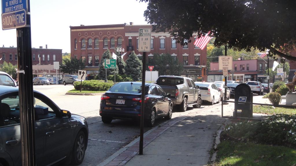
11 KEY FINDINGS Through an intensive data-driven and input from the public, several key discoveries emerged: There are 1,400 parking spaces, but many spaces are hard to find. There is a perception of lack of parking Many lots do not have clear or visible signage that indicates whether or not one can park there There are more than a dozen different types of regulations Half of off-street parking is "restricted access", meaning that the lots are not available to the general public There are some lots that are publicly owned and available to the general public, yet most of the stakeholders and workshop participants we spoke with did not know they existed Some parking areas are difficult to find from the roadway and/or challenging to access, so they end up being underutilized Overall signage is confusing to customers At peak (12:00 pm), parking is 56% full, meaning that more than 600 spaces are available. There are some areas that are consistently full all day (e.g. parking around the rotary is 90%+ full; South Street Lot is 80%+ full) Other areas almost always have availability, such as the small two-hour lot off the South Street Extension The imbalance of demand in downtown suggests that some spaces are more valuable than others Long-term parkers (e.g. employees) and short-term parkers (e.g. customers) compete over spaces. Employees and customers both park on Main Street and in the South Street Lot, often with employees taking up a majority of the parking before customers even arrive in town The short- and long-term competition suggests the need to incentivize employees to not park in the prime customer areas Lax enforcement of the two-hour on-street time limits, particularly on Main Street at and near the rotary, further confuses the long-term and short-term parking areas Customers report that parking is inconvenient. One-third of customers (via the online survey) reported that they do not come downtown more often because parking is inconvenient This is a critical barrier for existing businesses and attracting new businesses "Inconvenient" means different things to survey respondents: o Some report that they cannot find a space immediately in front of their destination o Others say that the two-hour time limits shorten their stay o Others do not know where to look to find parking, except on Main Street Nelson\Nygaard Consulting Associates Inc. 3
12 STRATEGIES AND RECOMMENDATIONS These findings and others were the foundation for developing the most impactful ideas and solutions to address these problems. To develop solutions, the Town hosted a two-day, open-door charrette in October This event included informal mark-up/open house sessions, plus formal public presentations and a walking tour. Residents, property owners, employees, and others provided ideas and possible solutions for a range of identified problems from navigating the rotary, to parking signage, to best management practices. The ideas developed at the charrette were vetted at a public meeting, and then further refined and documented in this report. Strategies and recommendations are grouped into the following categories: Add Parking Supply Although parking utilization counts indicate that there is ample supply to meet today's parking demand, adding parking supply in areas of high demand can help relieve some parking pressure and increase the number of "front door" spaces. Adding on-street parking within the existing right-of-way is the least expensive and easiest option; Hudson can fairly easily add about 65 spaces to its on-street parking supply. Creating a new off-street parking facility is generally more costly and will only be regularly used if it is in a desirable location or is surrounded by an excellent walking environment. There are several ways to better meet parking demand and increase capacity to the existing system: Add on-street parking to the existing right-of-way Make off-street parking more efficient Make better use of underutilized parking Add new off-street parking supply Add Availability in Key Areas Curbside and public parking are among the most important resources in downtown Hudson, and parking utilization counts show little availability in these critical areas. In support of Town goals of promoting local business and fostering a strong economic climate in Hudson, the Town should adopt several strategies to open up the areas that have the highest demand. The Town can make a big impact in the perception - and realities - of the most congested parking areas through these strategies: Adopt an availability goal (for example, targeting a number of spaces that would be available during the peak), which would allow Town staff to adjust parking rates and regulations to meet an adopted goal. 1 Actively manage high-demand areas via regulatory changes such as limited pricing, time limit extensions, and changes in duration to more closely match times of parking demand Introduce convenient payment technology with new, user-friendly parking payment systems such as parking apps and parking meters that accept credit cards 1 Hudson has not yet adopted a current goal, however such a goal should strive to meet best practices and industry standards such as 10% availability for on-street parking and 15% availability for parking lots. Nelson\Nygaard Consulting Associates Inc. 4
13 Add Information/Clarity Downtown Hudson could benefit from enhanced informational parking signage. Existing signage is sometimes inconsistent or unclear. Easy to read and understand parking and wayfinding signage is a critical component of deciphering a parking system, reducing customer confusion, and using spaces that wouldn't otherwise be used due to lack of signage or unclear information. There are four primarily mechanisms to enhance parking information in downtown Hudson: Wayfinding signage, to direct drivers & pedestrians to/from parking to destinations Regulatory signage, to clarify rules and regulations about where one can park Parking facility signage, to identify parking facilities Online and printed information Add Access Downtown Hudson is endowed with a dense Main Street that connects mixed-use retail, offices, and restaurants to nearby residential streets and neighborhoods. Downtown has an inviting historic, small-town appeal, and with its burgeoning restaurant scene, attracts employees, residents, and customers at all times of the day. However, there are several unfriendly walking areas downtown, including areas on South Street and at the rotary. These barriers and others impact the perception of parking proximity, and if left unaddressed, will not incentivize changes in parking behaviors, thus leaving spaces unused. The Town can improve its downtown environment while opening up underutilized parking areas through these efforts: Improve the pedestrian environment through lighting, landscaping, amenities, routine maintenance and public safety improvements Add bicycle infrastructure, including bicycle parking racks Create great public spaces such as parklets, green areas, and plazas Add Coordination Particularly in small towns, parking is often managed by multiple departments and decisionmaking bodies. This makes parking difficult to consistently coordinate among various groups. This is true in Hudson, where there is no central staff person or department that spearheads or oversees parking management in the context of larger Town goals. In addition, there are several aspects of the parking system that the Town has control over, compared to those that are in the hands of private landowners. For example, the zoning code could be updated with requirements for new developments to provide pedestrian and bicycle amenities and enforcement practices can be overhauled to manage parking via pricing instead of time limits. The Town should consider the following to improve its management of parking in Hudson: Centralize and coordinate parking functions Update the zoning code Upgrade enforcement practices Invest parking revenues downtown The recommendations are summarized in Figure 1. The strategies and recommendations are the result of a collaborative effort between Town staff, the business community, residents, and the consultant team, and provide a guide to smart parking management in support of downtown economic vitality for both the short- and long-terms. Nelson\Nygaard Consulting Associates Inc. 5
14 Figure 1 Downtown Hudson Parking Recommendations Nelson\Nygaard Consulting Associates Inc. 6
15 2 INTRODUCTION The is a historic community located in Middlesex County less than an hour directly west of the City of Boston. Hudson boasts a pedestrian-friendly downtown with bricklined sidewalks, generous tree canopies, historic architecture, streetlamps, and access to the regional Assabet River Rail Trail. Although downtown Hudson storefronts and office space have had high vacancy rates for the past two decades, the Town, in partnership with the Chamber of Commerce and Hudson Business Association, has recently begun to attract new restaurants and shops. Although the downtown recovery is a boon for businesses, the additional customers and employees strain existing parking and traffic infrastructure. As the Town continues to encourage new businesses to locate downtown, it is essential to understand the relationship between existing and expected land uses, vacancies, and parking supply and demand. Just as vital is preserving and emphasizing Hudson s walkable and bike-friendly environment through improvements to lighting, landscaping, bicycle parking, ADA compliance, and other amenities. There are two major infrastructure components that act as impetus for this study. The rotary on Main Street accommodates more than 6,900 cars from 4:00pm - 6: 00pm, which is heavy traffic volume, absorbing regional traffic via I-495 and State routes 85 and 62. The traffic volume is expected to be exacerbated by new developments that will generate significant additional traffic through the rotary. Hudson residents have mixed opinions about removing or redefining the rotary, noting its pleasant aesthetic and historic feel, but also sharing safety concerns for motorists and people walking downtown. Some rotary redesign proposals eliminate the existing parking 35 spaces, which are the highest demanded spaces in town. Feeding traffic directly into the rotary, the Washington Street Bridge is may be widened as part of a State s Accelerated Bridge Program, which will result in the loss of approximately five additional parking spaces. The bridge work will also have a short-term impact during construction, and a long-term impact on the rotary due to the widened bridge. The Town recognizes that parking is one integral piece of the economic development of Hudson s downtown commercial center. This Downtown Parking Study paints a comprehensive picture of parking activity and issues in downtown, with a focus on accommodating future downtown growth in a sustainable and fiscally responsible manner. The goal of this study is to develop a parking management plan that creates a vibrant, thriving, and more bike and pedestrian-friendly center for visitors, tourists, and residents, while maintaining access for merchants, their employees, residents, and their visitors. A smart parking management program considers all user needs, while maximizing available resources, before investing in new ones. This can only be addressed through a comprehensive parking program. STUDY PURPOSE This study establishes a broad, yet detailed benchmark of current parking and land use conditions in downtown Hudson and identifies short and long term strategies to support downtown revitalization. The project includes public input on the unique motivations, characteristics, and Nelson\Nygaard Consulting Associates Inc. 7
16 sensitivity to policy changes, and the study recommendations are developed within this framework. Understanding and context is the key to realistic and workable recommendations. Public input is joined with the findings from the parking data collection, zoning, land use, and other analyses that directly inform the study recommendations. This study provides a point of reference for community discussion and policy decisions on parking, the transportation system, and land use. The downtown parking study is intended to address the following specific goals: Improve availability for customers Clarify short- and long-term parking areas Evaluate parking supply and demand based on expected land use changes/development Assess parking in the context of a multi-modal downtown ABOUT THE REPORT This report includes maps, tables, and summaries organized under the following headings: Parking Inventory A review of all parking spaces by location and regulation as identified by posted signage Parking Utilization and Turnover Observed use of existing parking through the course of a typical weekday and weekend, which includes utilization profiles of "core" areas, general and restricted access lots, and publicly and privately owned lots Public Process A summary of the public outreach efforts, including the online survey results, stakeholder interviews, and public meetings Land Use Analysis Technical summary of existing and future land uses and how they relate to parking supply and demand Zoning Code Analysis Detailed analysis of the parking provisions within the Town s Zoning By-Laws Strategies and Recommendations Explanation of ideas to directly address parking and parking-related concerns in downtown Hudson The data summarized in this report was collected in September 2014 by Nelson\Nygaard Consulting Associates. STUDY AREA The Downtown Hudson Parking Study area (see Figure 2) encompasses about half a mile around the core of the downtown area, centered along Main Street and South Street and bounded by: Pleasant Street to the north Robinson Hardware and the Hudson Public Library to the west Broad and Manning Streets to the east School Street to the south The study area has significant on and off-street parking assets, with 59 public and private off street parking lots downtown. This includes Town-owned assets and also many restricted-use lots for customers of local businesses, visitors, and employees. On-street parking is also available throughout the study area. Half of the on-street parking spaces are unrestricted and half are regulated as two-hour parking to prevent long-term on-street parking. Nelson\Nygaard Consulting Associates Inc. 8

17 Overall, the downtown Hudson study area includes approximately 1,408 total parking spaces, with 1,091 off-street and 317 on-street parking spaces. Figure 2 Downtown Hudson Study Area RELATED STUDIES 2014 Master Plan At the time of this project, the Town was nearly complete with its Master Plan update. The updated Master Plan provides a framework for ensuring that Hudson continues to preserve its character and enhance public infrastructure and services. The plan highlights several goals in relation to transportation and economic development including: Balance traffic flow needs with the desire to make roadways more bicycle and pedestrianfriendly Introduce public transportation at an appropriate and affordable scale Seek funding to advance transportation infrastructure needs Ensure that paratransit service meets the needs of elderly and disabled residents Concentrate development to ensure that it uses existing infrastructure Protect the village character and local businesses Redevelop existing built resources first Encourage location of new businesses near housing and existing infrastructure Nelson\Nygaard Consulting Associates Inc. 9
18 Foster sustainable natural resource-based businesses and agriculture The plan also identified several parking issues: Perception of inadequate parking available to the public, especially downtown Potential impact of parking requirements on development Need for a management system for the community s parking resources Recommendations were developed for parking, economic development, and land use: Create a parking study and plan with current and future needs Increase publicly available parking, especially through future development proposals Create reserved and/or dedicated parking supply for public buildings Review parking regulations to see if they inhibit restaurants or nightlife Update parking standards with minimums and maximums Explore additional public parking on South Street Other Related Plans and Studies The Hudson Community Development Strategy FY 2013 recommended that the town optimize the Historic District and seek funds to reconstruct downtown roads, add strategic parking areas, and install trees and period street-lighting to help nurture a special identity for this area. The plan observed that downtown has traffic congestion, parking deficiencies, vehicular circulation problems, and other infrastructure issues. It recommends a parking garage or new surface parking lots as a solution to these issues. The Hudson Business Association Survey ( ), which was posted online for public input at the HBA website, identified parking and traffic issues as one of the main reasons why people do not go to downtown Hudson. The 2004 Hudson Community Development Plan recommended that downtown Hudson maintain its strong sense of place in all future development proposals and changes to by-laws and regulations. The Urban River Visions report provides the outcome of a two-day visioning session during which the community discussed how to utilize the Assabet River as a revitalization tool for downtown Hudson. The report determined that an integrative parking strategy is needed to meet existing and potential demand, which should include better signage, information, pedestrian connections, and a feasibility study to determine if a parking garage is needed. Nelson\Nygaard Consulting Associates Inc. 10
19 3 PARKING INVENTORY This chapter documents the current conditions of downtown Hudson s parking facilities based on existing Town data and an extensive data collection effort conducted by Nelson\Nygaard in September Figure 3 shows parking facilities in downtown Hudson, including all public parking assets, private and restricted parking lots, and on-street spaces within the defined study area, excluding small private driveways. Data was compiled and used to create a complete parking database of all parking facilities in the study area, which was then geo-coded to spatially display the existing parking facilities, as shown in Figure 6. PARKING INVENTORY: KEY FINDINGS There are 1,408 parking spaces in downtown Hudson 77% of parking spaces are off-street; 23% are on-street All on-street parking spaces are available for general use, meaning that anyone can park on-street, regardless of trip purpose (e.g. no "residential only" on-street parking) The majority of the off-street supply is restricted / private use (69%); only 31% of the offstreet parking supply is available for public use. Figure 3 Parking Inventory Parking Location Number of Spaces Percentage % Public Use % Restricted-use / Private Off-Street 1,091 77% 31% 69% On-Street % 100% 0% Total 1, % PARKING REGULATIONS The team catalogued the ownership, use category, and regulation for all parking spaces within the study area. Figure 4 and Figure 5 summarize the on- and off-street parking spaces by regulation. A full parking inventory map is depicted in Figure 6. On-Street Parking All of the on-street parking in downtown Hudson is available for public use (not privately owned), but there are still restrictions placed on half of the supply based on how long a user can park. Time Limited Parking: 45% of on-street parking spots downtown have a two-hour time limit (with 23 of these spaces limited to two hours and no overnight parking). Another 4% of on-street parking is limited to 15-minutes. These time-limited spaces are regulated to encourage parking turnover, preserving them for patrons of the shops and restaurants, and discouraging long-term employee parking. There is also a small percentage (1%) of parking spaces reserved for disabled parking. Nelson\Nygaard Consulting Associates Inc. 11
20 Unrestricted: Half of all on-street parking downtown is unrestricted, meaning that there are no signs restricting or prohibiting parking, regardless of the time of day or duration. Figure 4 On-Street Parking Regulations Regulation Total % Unrestricted % 2 Hour % 15 Minute 13 4% Disabled 4 1% Total % Off-Street Parking Off-street parking has been categorized three ways to focus on who can use the parking: Unrestricted / publicly-accessible parking is available for public use and may be owned by a public or private entity Restricted-use / private parking is dedicated to a specific population, which are primarily private parking lots that are restricted to particular customers, tenants, or employees of the (typically adjacent) use. In Downtown Hudson these uses include private business, senior center, boys and girls club, municipal employee, residential, post office, and church. Time-restricted publicly-accessible parking is regulated to encourage parking turnover in areas where patrons of shops and restaurants need short-term parking, which will discourage long-term parking of employees and residents. 8% of the off-street parking supply is two-hour parking and 1% (7 spaces) are 30-minute. The majority of off-street parking in downtown Hudson (69%) is restricted-use parking. Publiclyaccessible and restricted-use off-street parking can be further categorized into specific uses, as shown in Figure 5. Figure 5 Off-Street Parking Regulations Regulation Total % Private Business % Unrestricted publicly-accessible % 2 Hour 82 8% Senior Center 41 4% Boys and Girls Club 24 2% Municipal Employees Only 21 2% Residential 11 1% Post Office 10 1% 30 Minute 7 1% Church 6 1% Total %. Nelson\Nygaard Consulting Associates Inc. 12

21 Figure 6 Parking Supply and Regulations Nelson\Nygaard Consulting Associates Inc. 13
22 4 PARKING UTILIZATION AND TURNOVER In downtown Hudson, similar to many downtown areas, there is a perception that there is not enough parking. In reality, parking is at ideal capacity when there is at least one empty space per block face, ensuring easy customer access to businesses, but also allowing for a bustling downtown environment. This typically equates to a target of 10-15% vacancy per block face and within parking lots. If any street segment or parking facility has less availability than 10-15%, it is effectively at its functional capacity. This chapter contains parking utilization counts for the study area, providing a snapshot of the time and location of parked cars for a typical day. The project team conducted parking utilization counts on a weekday (Thursday) and a weekend day (Saturday). On Thursday, data collectors captured parking demand every two hours from 8:00 am to 10:00 pm to comprehensively monitor the full work-day and after work activities. Thursday was picked due to a typically busier happy hour and dinner crowd than most other weeknights. On Saturday data were collected during a shorter period, every two hours from 10:00 am to 8:00 pm. To gather data, the team counted parked cars in each on-street segment or lot at the predetermined time intervals, while also observing the land usage, regulation, and signage, which can drastically impact parking rates. By comparing parking utilization spatially, patterns of high or low usage are more easily identified, as well as the impact of regulations and how much of the parking supply is used in a typical day. The team conducted parking turnover analysis on a Thursday during the peak lunch period from 10:00 am to 2:00 pm on Main Street, from the rotary to Broad Street. Observations of the time and duration parked by each car in every space were collected in 30-minute increments using license plates. This analysis determines the length of stay of vehicles, which is relevant to the 15- minute and two-hour parking regulations. The team also completed a turnover sweep of the unregulated public parking areas on Felton Street, Pope Street, Railroad Avenue, and Church Street, at 9:00 am, 2:00 pm, and 5:00 pm, to understand if these spaces are being used by longerterm parkers (employees and residents) or for shorter-term stays. This chapter first analyzes weekday temporal and spatial patterns, followed by weekend patterns, and lastly focuses on specific blocks where the team conducted parking turnover counts. Nelson\Nygaard Consulting Associates Inc. 14
23 WEEKDAY PARKING UTILIZATION WEEKDAY DEMAND: KEY FINDINGS General Overall, all parking is never more than 56% occupied. More than 600 parking spaces are available at the busiest time of day. Publicly available off-street parking is 62% full at peak. Parking on Main Street is the busiest area in downtown with four of five spaces filled during the busiest periods. Mid-day Peak Period The peak mid-day period begins around 10:00 am with high utilization of the two-hour on-street parking along Main Street around the rotary (Figure 12). However, a few minutes walk further down Main Street there are several sections of two-hour parking far below capacity. Several of the restricted-use lots used by local businesses are at capacity, but several of the small public use lots are underutilized. By 12:00 pm, the unregulated public lot on South Street is at capacity. The two-hour lot, which is adjacent, is still underutilized (Figure 13). The two-hour on-street parking on the right side of Church Street is at capacity for the entire mid-day peak period, but the parking on the left side (also two-hour) is underutilized. Evening Peak In the evening (6:00 pm 8:00 pm), parking activity shifts away from the rotary to further down Main Street, the South Street Lot, the unregulated stretches of on-street parking north of Main Street, and along South Street, yet there is still plenty of parking available a minutes walk away (Figure 16 and Figure 17). The unregulated parking lot on South Street is nearly full, but the adjacent two-hour parking lot is nearly empty. Nelson\Nygaard Consulting Associates Inc. 15
24 Entire Study Area The peak period of parking activity on Thursday in Downtown Hudson is around 12:00 pm, when parking is 56% full (Figure 7). During the lower utilization periods parking activity does not reach above 46% full, which is far below maximum capacity of 90% of all spaces occupied. Figure 7 Parking Utilization Study Area (THURSDAY) 100% 80% 60% 40% 20% 0% Occupied Vacant am 10am 12pm 2pm 4pm 6pm 8pm Parking Utilization by Type of Parking As shown in Figure 8, there is abundant parking available both on-street and in off-street parking lots during the weekday. Utilization of on-street spaces is slightly higher (58%) during the peak period than off-street during the same period (56%). Figure 8 Parking Utilization Off-Street vs. On-Street (THURSDAY) Off-Street On-Street 100% Occupied Vacant 100% Occupied Vacant 80% 60% % 60% % 20% 0% am 10am 12pm 2pm 4pm 6pm 8pm 40% 20% 0% am 10am 12pm 2pm 4pm 6pm 8pm Nelson\Nygaard Consulting Associates Inc. 16
25 Parking Utilization by Public vs. Restricted Use / Private Figure 9 shows utilization of publicly-accessible parking and restricted-use / private parking. Utilization of publicly-accessible parking reaches 62% utilization during the peak period, while restricted-use / private parking only reaches 53%. Publicly-accessible parking stays between 40%- 50% full throughout the day, while restricted-use / private parking decreases steadily after 2:00 pm, as employees begin to leave their work shifts. Figure 9 Parking Utilization Restricted-Use vs. Publicly-Accessible (THURSDAY) Publicly-Accessible Restricted-Use / Private 100% Occupied Vacant 100% Occupied Vacant 80% 60% % 60% % 20% 0% am 10am 12pm 2pm 4pm 6pm 8pm 40% 20% 0% am 10am 12pm 2pm 4pm 6pm 8pm Parking Utilization of Discrete Areas As shown in Figure 10, parking utilization of three discrete areas within Downtown Hudson are higher than the overall utilization of the study area. In the two-hour on-street parking spaces along Main Street and side streets connected to Main Street, utilization reaches 80% at 12:00 pm and stays at least half full for most of the day. The South Street Lot is well utilized throughout the day, and reaches near capacity (87%) in the evening. The lot at the library is not as well utilized as the other two areas, but does reach past 60% in the afternoon period. Nelson\Nygaard Consulting Associates Inc. 17

26 Figure 10 Parking Utilization Discrete Areas (THURSDAY) 2 Hour On-Street Parking 100% 80% 60% 40% 20% 0% Occupied Vacant am 10am 12pm 2pm 4pm 6pm 8pm South Street Lot 100% 80% 60% 40% 20% 0% Occupied Vacant am 10am 12pm 2pm 4pm 6pm 8pm Lot at the Library 100% 80% 60% 40% 20% 0% Occupied Vacant am 10am 12pm 2pm 4pm 6pm 8pm Nelson\Nygaard Consulting Associates Inc. 18
27 WEEKDAY SPATIAL ANALYSIS An important part of understanding how parking is managed in any downtown is being able to see how various parking facilities and segments of on-street parking interact with each other throughout the course of a day. A chart of hourly utilization rates for one specific location is valuable, but seeing how that location behaves among others located nearby can reveal patterns and trends not evident in numbers alone. The lot which is completely full may be right around the corner from another lot that has plenty of availability at that same time. To develop the spatial analysis, the parking utilization data collected during the parking counts was geo-coded to be displayed on a series of maps. The maps show the use of each parking facility by color-code, as explained below. The "breaks" (0-60% full; 60-80% full; 80-90% full; % full; more than 100%) are used to evaluate the fullness of a parking facility and are based on national standards that indicate when a parking area is functionally full. Cool light blue/blue refers to 0-60% and 60-80% utilization, points at which onstreet blocks and off-street facilities are viewed as underutilized. Any resource that consistently performs at this level, especially during peak-demand periods should be viewed as excess capacity. Ideal green refers to blocks and facilities with 81% to 90% utilization and represents actively-used resources. The nearer utilization levels approach the high end of this range, the more efficiently they are being utilized and nearing functional capacity. Warning pink refers to utilization above 91% and is considered at functional capacity. While fully maximizing efficiency, these blocks or facilities are full or near full, giving the impression of lack of parking. Critical red denotes parking beyond the marked capacity (more than 100%). Resources that consistently perform at this level indicate that demand exceeds capacity. Nelson\Nygaard Consulting Associates Inc. 19
28 Figure 11 Parking Utilization - Thursday 8:00 am Nelson\Nygaard Consulting Associates Inc. 20
29 Figure 12 Parking Utilization Thursday 10:00 am Nelson\Nygaard Consulting Associates Inc. 21
30 Figure 13 Parking Utilization Thursday 12:00 pm Nelson\Nygaard Consulting Associates Inc. 22
31 Figure 14 Parking Utilization Thursday 2:00 pm Nelson\Nygaard Consulting Associates Inc. 23
32 Figure 15 Parking Utilization Thursday 4:00 pm Nelson\Nygaard Consulting Associates Inc. 24
33 Figure 16 Parking Utilization Thursday 6:00 pm Nelson\Nygaard Consulting Associates Inc. 25

34 Figure 17 Parking Utilization Thursday 8:00 pm Nelson\Nygaard Consulting Associates Inc. 26
35 WEEKEND PARKING UTILIZATION WEEKEND DEMAND: KEY FINDINGS General Overall, all parking is never more than 38% occupied. More than 850 parking spaces are available at the busiest time of day. On-street parking is busier than off-street parking (45% full compared to 36% full). Weekends have more available parking than weekdays. Mid-Day Peak Period Parking activity on the weekend is heaviest on the two-hour on-street parking along Main Street during the mid-day peak period, as shown in Figure 22 and Figure 23. At 10:00 am, there are a couple of blocks near and around the rotary that are at capacity, but the majority of spaces further down Main Street are empty. The unregulated on-street parking along Felton Street is over capacity, but the next block of unregulated parking along Felton Street is underutilized. All of the public parking lots have plenty of empty spaces. Around 12:00 pm parking activity increases in those same areas, especially around the rotary on Main Street, however there is still plenty of parking available a block away. Evening Peak In the evening (around 6:00 pm) parking activity shifts away from the rotary to further down Main Street and the unregulated parking lot in the South Street Lot. Both the unregulated lot and the two-hour public lot on South Street have parking available. Nelson\Nygaard Consulting Associates Inc. 27
36 Entire Study Area Parking activity on Saturday peaks around 10:00 am at 38%, which is much lower than during the weekday (Figure 18). Parking utilization decreases steadily for the rest of the day, with a slight uptick in the evening, likely from patrons of local restaurants parking to go to dinner. Figure 18 Parking utilization for the entire study area (SATURDAY) 100% 80% 60% 40% 20% 0% Occupied Vacant am 12pm 2pm 4pm 6pm Parking Utilization by Type of Parking As shown in Figure 19, utilization of off-street parking spaces only reaches 35% during the peak period of 10:00 am on Saturday, while on-street utilization is slightly higher at 45%. Off-street parking lots are less full than on-street parking throughout the day. Figure 19 Parking Utilization Off-Street vs. On-Street (SATURDAY) Off-Street On-Street 100% Occupied Vacant 100% Occupied Vacant 80% 60% % 60% % 40% 20% 0% am 12pm 2pm 4pm 6pm 20% 0% am 12pm 2pm 4pm 6pm Nelson\Nygaard Consulting Associates Inc. 28
37 Parking Utilization by Public vs. Restricted Use / Private Restricted-use / private parking spots are less full (31%) than publicly-accessible spots (45%) on the weekend, as shown in Figure 20. Publicly-accessible parking stays at half capacity throughout the day, while restricted-use parking peaks at 10:00 am and steadily becomes emptier throughout the day. Figure 20 Parking Utilization Restricted-Use vs. Publicly-Accessible (SATURDAY) Restricted-Use / Private Publicly-Accessible 100% Occupied Vacant 100% Occupied Vacant 80% 60% % 60% % 40% 20% 0% am 12pm 2pm 4pm 6pm 20% 0% am 12pm 2pm 4pm 6pm As shown in Figure 21, within the two-hour parking spaces along Main Street, utilization peaks at 58% full around 10:00 am, then decreases for the rest of the day until around 6:00 pm when it increases again to 54% full. In the South Street Lot, utilization stays between 50%-60% full throughout the day, but then spikes around 6:00 pm to 83% full. In the lot at the library, utilization reaches 49% at 10:00 am and decreases steadily throughout the rest of the day. Nelson\Nygaard Consulting Associates Inc. 29

38 Figure 21 Parking Utilization Discrete Areas (SATURDAY) 2 Hour On-Street Parking Occupied 100% 80% 60% % 20% 0% am 12pm 2pm 4pm 6pm South Street Lot Occupied 100% 80% % 40% 20% % 10am 12pm 2pm 4pm 6pm Lot at the Library 100% Occupied 80% 60% 40% 20% 0% am 12pm 2pm 4pm 6pm Nelson\Nygaard Consulting Associates Inc. 30
39 WEEKEND SPATIAL ANALYSIS As explained in detail above, the following spatial analysis displays the utilization data geo-coded on a series of maps. The maps show the use of each parking facility by color-code, as explained below. Cool light blue/blue refers to 0-60% and 60-80% utilization, points at which onstreet blocks and off-street facilities are viewed as underutilized. Ideal green refers to blocks and facilities with 81% to 90% utilization and represents actively-used resources. Warning pink refers to utilization above 91% and is considered at functional capacity. Critical red denotes parking beyond the marked capacity (more than 100%). Nelson\Nygaard Consulting Associates Inc. 31
40 Figure 22 Parking Utilization Saturday 10:00 am Nelson\Nygaard Consulting Associates Inc. 32
41 Figure 23 Parking Utilization Saturday 12:00 pm Nelson\Nygaard Consulting Associates Inc. 33
42 Figure 24 Parking Utilization Saturday 2:00 pm Nelson\Nygaard Consulting Associates Inc. 34
43 Figure 25 Parking Utilization Saturday 4:00 pm Nelson\Nygaard Consulting Associates Inc. 35
44 Figure 26 Parking Utilization Saturday 6:00 pm Nelson\Nygaard Consulting Associates Inc. 36

45 PARKING TURNOVER The study completed parking turnover analysis on a Thursday during the peak lunch period from 10:00 am-2:00 pm on Main Street, from the rotary to Broad Street. Observations of the time and duration parked by each car in every space were collected in 30-minute increments using license plates. This analysis determines the length of stay of vehicles, which is particularly relevant due to the 15-minute and two-hour parking regulations. The team also completed a turnover sweep of the unregulated public parking areas on Felton Street, Pope Street, Railroad Avenue, and Church Street, at 9:00 am, 2:00 pm, and 5:00 pm, to understand if these spaces are being used by longer-term parkers (employees and residents) or for shorter-term stays. TURNOVER COUNTS ON MAIN STREET: KEY FINDINGS In two-hour spaces, the average length of stay was 53 minutes In 15-minute spaces, the average length of stay was 50 minutes 12 of 73 spaces, or one space out of every seven, was used for more than two hours despite the two hour time limit Cars staying for longer than two hours these cars were parked around the rotary and between Town Hall Figure 27 Location of Cars that Stay Longer than Two Hours Nelson\Nygaard Consulting Associates Inc. 37
, which could be residents or employees There is no distinct spatial pattern; long-term parkers use almost all of these unregulated")
46 TURNOVER COUNTS NORTH OF MAIN STREET: KEY FINDINGS A majority of cars (55%) parked for less than three hours, which are likely customers/visitors Nearly one-third of cars parked for three to five hours 13% of cars were parked all day (from 9:00 am - 5:00 pm), which could be residents or employees There is no distinct spatial pattern; long-term parkers use almost all of these unregulated blocks Figure 28 Location of Cars that Park All Day Nelson\Nygaard Consulting Associates Inc. 38


47 5 PUBLIC PROCESS The understands that parking utilization and other quantitative data do not tell the whole story of complex downtown parking environments. Throughout this process, the Town made it a priority to include community input on an ongoing basis. This was not just important for Hudson residents and employees, but also for the study team to better understand the parking data and field observations. Perception is often the reality with parking issues, so understanding parking concerns from the user perspective is of utmost importance. This helps all stakeholders work from the same page and reveals how observed parking patterns are created by how people perceive and use the system. This effort included multiple opportunities for public input, including an online survey (that received nearly 750 responses), four public meetings, a 1.5 day open-door parking charrette, a dozen stakeholder interviews, and an active project website that welcomed ed comments and input. Key themes and findings from the public process are summarized in this chapter. PUBLIC KICK-OFF WORKSHOPS On June 17 th, 2014, the Town convened two public kick-off workshops. Advertised on the Town website, various listservs, the Assabet Valley Chamber of Commerce, the Metrowest Daily News, and others, all were welcomed to the auditorium at Town Hall. These drop-in sessions were hosted from 8:00 am - 10:00 am and from 7:00 pm - 9:00 pm. Participants included Hudson residents, business owners, property owners, and downtown employees, who all brought various perspectives and issues to the table. Nelson\Nygaard made a presentation that outlined the study process, schedule, and scope, and identified initial findings regarding work to date on Hudson s current parking situation. Participants were invited to ask questions, voice concerns, and offer ideas and solutions. Figure 29 Public Kick-Off Workshops: Community Map Mark-Ups Participants write and discuss issues and opportunities on the study area map Nelson\Nygaard Consulting Associates Inc. 39

48 Figure 30 Summarized Public Comments on Issues and Opportunities Nelson\Nygaard Consulting Associates Inc. 40
49 ONLINE SURVEY The perceptions, experiences, and preferences of people who park in downtown Hudson were collected through an online survey. The survey was open from July to September 2014, and garnered about 750 responses. The sections below outline the responses and trends in the survey data, including conclusions from both the quantitative and qualitative survey responses. ONLINE SURVEY: KEY FINDINGS Reasons for going downtown Most survey respondents go to downtown Hudson for errands, appointments and dining The majority of respondents go downtown several times per month or several times per week Respondents come to downtown to shop and eat locally and because it s convenient to where they live Respondents avoid downtown sometimes because parking and traffic are inconvenient and there aren t enough stores Parking patterns Customers generally park on-street, while employees park in parking lots The majority of both customers and employees park on Main Street or in the South Street Lot Employees park directly in front of their destination or within the same block at a higher rate than customers Customers are more willing to walk from where they parked to their destination than employees A large majority of employees find parking within five minutes, while a small majority of customers find parking within the same period The majority of customers have failed to find parking in downtown Hudson, but this only happens a few times a year Common comments Additional comments from survey respondents included the following: Congestion issues: o There s too much traffic, especially during the peak hours o There s congestion and traffic at the rotary o The parallel parking on Main Street backs up traffic Parking limitations o There s a shortage of space in the evening and during special events o There are not enough parking spaces for employees o There are not enough public parking lots and too many private lots o There are not enough disabled spaces Nelson\Nygaard Consulting Associates Inc. 41
50 Reasons for going to downtown Hudson The majority of people go to downtown Hudson for errands and appointments (33%) and for dining (41%) and arrive via a private vehicle (95%). 4% of people walk to the downtown and 0.7% either carpool or bike. Of those running errands and going to appointments, when asked what their destination was, respondents said that they were headed to the library (28%), a salon (14%), a karate class (12%), a bank (8%), or the post office (7%). Of those respondents who identified themselves as customers, 48% visit downtown Hudson several times per month for shopping, running errands or appointments, and dinning, and more than 30% of them visit several times a week. As shown in Figure 32, the top three reasons that people come to downtown Hudson is because it s convenient to their home (24%), they want to purchase items and dine locally (22%), and they want a unique dining experience (16%). They also appreciate being able to walk to many different destinations (10%) and the safe and secure nature of downtown (9%). The top three reasons that people do NOT go to downtown Hudson is because parking is inconvenient (38%), there are not enough stores (21%), and there is too much traffic (19%), as shown in Figure 33. Figure 32 Reasons People Visit Downtown Hudson Figure 31 Why do you come to Downtown Hudson? Other 8% I live downtown 2% Errands/ Appointments 33% Shopping 5% Work 11% Dining 40% Convenient to my home Want to purchase items/dine locally Unique dining experience Able to walk to many different services and shops I feel safe and secure Unique services Can find what I need Convenient to my work Bump into neighbors Unique shopping experience I work here Others 0% 5% 10% 15% 20% 25% Nelson\Nygaard Consulting Associates Inc. 42
51 Figure 33 Reasons People Do NOT Visit Downtown Hudson Parking is inconvenient Not enough stores Too much traffic Cannot find what I need Not enough restaurants Not convenient to walk around downtown Others Parking patterns Customers and employees have very different parking patterns. As shown in Figure 34, 62% of customers park on-street, while only 38% park in a lot. Employees overwhelmingly park in the lots (81%), while only 19% park on-street. Figure 34 Where Are People Parking in Downtown Hudson? 0% 5% 10% 15% 20% 25% 30% 35% 40% Customers Parking Lot 38% On- Street 62% Employees Parking Lot 81% On- Street 19% As shown in Figure 35, of the customers who park off-street, 48% park in the South Street Lot, 23% park in a private lot, and 16% park in the public library lot. Customers who park on the street largely do so on Main Street (65%). About 20% park either on Pope Street or Church Street and only 5% park on South Street. Nelson\Nygaard Consulting Associates Inc. 43
52 Figure 35 Where Do Customers Park? South Street Lot (X3) Public Library Lot Town Hall Lot South Street Skate Park Lot Senior Center Lot Private Lot/ Other Off-Street 0% 20% 40% On-Street Main Street Church Street Market Street School Street Railroad Avenue Manning Street Other 0% 20% 40% 60% 8 Employees park in the same location as customers, as shown in Figure 36. In off-street lots, employees primarily park in the South Street Lot (33%) or private lots (31%), and also park in the public library lot (14%) or the Town Hall Lot (13%). More than half of employees who park onstreet do so on Main Street, while 33% either park on Pope Street, Church Street, or Felton Street. Figure 36 Where Do Employees Park? Off-Street On-Street South Street Lot (X3) Public Library Lot Town Hall Lot South Street Skate Park Lot Post Office Lot Senior Center Lot Private Lot/Other Main Street Pope Street Church Street Felton Street South Street 0% 20% 40% 60% 0% 20% 40% The majority of employees and customers (78% and 71%, respectively) are both parking within one block of their destinations, as shown in Figure 37. Alarmingly, employees are scoring the parking spots directly in front of the places their destinations at higher rates than customers (22% vs. 16%). Employees are also parking on the same block as their destination at higher rates than customers (29% vs. 26%). Customers are more likely than employees to park two or more blocks away, although only 29% of customers park farther than one block away. Similarly, customers are more willing to park further away from their destination than employees (Figure 37). 38% of customers are willing to park two blocks away from their destination, while only 23% of employees are willing to do so. Many employees (38%) are only willing to walk one block from their destination. Nelson\Nygaard Consulting Associates Inc. 44
53 Figure 37 How Far Did You Park From Your Destination? 40% 30% 20% 10% 0% Right in front Same block One block away Two blocks away Visitors/Customers Employees Three blocks away More than three blocks away Figure 38 How Far Are You Willing to Walk From Parking to Your Destination? 40% 30% 20% 10% 0% Visitors/Customers Employees 1/2 Block One Block Two Blocks Three Blocks or more The majority of employees (72%) were able to find parking within five minutes on the day that they took the survey, as shown in Figure 39. On an average day, 61% of employees were able to find parking within five minutes. On their worst day, more than half of employees spent more than 10 minutes searching for parking. Figure 39 How Long Does It Take For You To Find Parking? (Employees Only) 60% 50% 40% 30% 20% 10% 0% Immediately 1-4 minutes 5-9 minutes More than 10 minutes Today Average Worst Figure 40 shows that 54% of customers were able to find parking within five minutes on the day that they took the survey. On an average day, 30% of customers are able to find parking within five minutes. On their worst day, 65% of customers spent more than 10 minutes searching for parking. Nelson\Nygaard Consulting Associates Inc. 45
54 Figure 40 How Long Does It Take For You To Find Parking? (Customers Only) 80% 60% 40% 20% 0% Immediately 1-4 minutes 5-9 minutes More than 10 minutes Today Average Worst The majority of customers (63%) have failed to find parking in downtown Hudson, as shown in Figure 41; however the majority of these instances occur rarely or only several times per year (79%). A small percentage (7%) occurs during a festival or event. Figure 41 Have You Ever Failed To Find Parking In Downtown Hudson? (Customers Only) Have you ever failed to find parking? If so, how often does this happen? No 37% During a festival/event 7% Weekly 3% Several days a month 11% Yes 63% Rarely 36% Several times a year 43% Nelson\Nygaard Consulting Associates Inc. 46
55 STAKEHOLDER INTERVIEWS The review of background information, online surveys, and public meetings were complemented by a series of targeted stakeholder interviews that gathered input on conditions from those very familiar with parking in downtown Hudson. Stakeholders were identified by Town staff. Interviewed Stakeholders Assabet Valley Chamber of Commerce Avidia Bank Calare Properties Horseshoe Pub Hudson Appliance Hudson Business Association Michael Murphy Sereni Salon Several property owners Town staff STAKEHOLDERS: KEY FINDINGS The primary goal of the stakeholder interviews was a free flowing exchange about parking and an understanding of specific experiences and perspectives in downtown Hudson. Several common themes emerged: There is not enough parking downtown. The South Street Lot and Main Street are often full. Numerous stakeholders mentioned that it is hard to find parking in the South Street lot. More parking supply is needed, particularly at night. Downtown Hudson needs better signage and wayfinding to alert visitors to the public parking lots. Stakeholders recommend sidewalk improvements and additional lighting throughout downtown to ensure a safe walking environment throughout the day and night. Employees are parking in the spaces directly in front of the shops and restaurants where they work, which take these prime spaces away from customers. Stakeholders think the problem can be mostly solved by educating employees on why they shouldn t park in the prime on-street spaces. Visitors to downtown Hudson do not know where to park. Stakeholders agreed that the parking postcard is providing a resource for visitors, but there needs to be a better way to get it out to visitors. Parking during events and festivals can be problematic, which will only increase with the new brewery being added on Main Street, which will likely encourage additional activity downtown. The two-hour restriction on the public lot on South Street and the on-street spaces on Main Street is not conducive to the type of businesses in downtown, such as restaurants, bars, and hair salons where customers typically want to stay for longer than two hours. Nelson\Nygaard Consulting Associates Inc. 47


56 PUBLIC CHARRETTE The hosted a twoday parking management charrette in the Town Hall Auditorium. The purpose of the charrette was to generate ideas and solutions to identified parking problems. The Auditorium doors were open to anyone that wanted to participate, and participants worked side-byside with consultants and Town staff to create and refine ideas. On top of the open house hours, the team led a community walking tour. Participants were able to identify areas of concern and discuss potential solutions. Additionally, Nelson\Nygaard hosted two presentations, one at lunchtime on Day 1, which focused on key findings from the parking data collected, and a final presentation at the end of Day 2, presenting some ideas and strategies developed at the charrette. Several themes emerged throughout the two-day charrette: participants expressed that downtown needs better parking signage, information, and education; employees park in prime on-street spots in front of businesses; and the lack of consistent enforcement. Participants also raised concerns over traffic and parking near the rotary and the difficulty crossing Main Street on foot. Figure 43 Charrette Mapping and Walking Tour Figure 42 Parking Charrette Schedule Nelson\Nygaard Consulting Associates Inc. 48
57 6 LAND USE ANALYSIS Parking does not exist independently, but it is intricately intertwined with the overall mix of land uses and activities it serves. As downtown Hudson evolves and attracts a variety of land uses, this relationship is critical. This chapter explores the current relationship between existing land use and parking, and models the expected land use and parking given known and potential development. Downtown Hudson does not represent typical suburban development. The historic downtown, mix and proximity of land uses, walkable environment, active small-scale retail, and growing local dining scene helps enhance its local feel. When land is at a premium in this center of activity, careful consideration of what the land is dedicated to (built environment, roadways, open space, parking) has a significant impact on the vitality of downtown. This chapter uses a model to understand the ratio of land use and parking supply and demand in three sub-areas of activity in downtown. The model determines how much parking would be needed assuming that parking is shared between land uses and people (customers, employees, visitors) visiting multiple destinations. The combined results of these analyses are then compared to the actual observed parking demand. Each activity area also includes a short-term buildout scenario (expected, known developments) and a potential full-buildout scenario, which shows the long-term maximum growth for identified parcels. ABOUT LAND USE AND PARKING RATIOS The Institute of Transportation Engineers (ITE) produces a periodic report titled Parking Generation, which is the prevailing national standard in determining parking demand for a development. ITE standards are based on parking demand studies submitted to ITE by a variety of parties, including public agencies, developers and consulting firms. The most recent parking generation manual available is the 4th edition (2010) and is a comparative starting point to determine baseline assumptions. This study includes ITE peak period parking demand rates as guidelines to benchmark how the existing parking supply in Hudson compares to its land uses. Expected parking demand is a way to examine the amount of parking that would be needed to support the level of development and activity present within the study area. In this case, the analysis is completed using industry standard methodology to equate land use with expected parking demand. ITE parking standards are often based on peak hour demands of suburban sites with isolated, single land uses which have free parking (Institute of Transportation Engineers, Parking Generation 4th Edition, 2010, page 2). Nelson\Nygaard s experience indicates that projections using standard ITE parking rates tend to overestimate demand for downtown areas like Hudson. Mixed-use areas offer the opportunity to share parking supply between various uses. This reduces the total number of spaces which would be required by the same land-uses in standalone developments. Nelson\Nygaard Consulting Associates Inc. 49
. Besides demand by time of day, we tailored the shared parking model for Hudson to include a parking demand reduction for internal capture.")
58 To model a park-once environment, Nelson\Nygaard used an adapted shared parking model using inputs from the Urban Land Institute's (ULI) Shared Parking Manual (2nd Edition, 2005) and ITE's Parking Generation (4th Edition, 2010). Besides demand by time of day, we tailored the shared parking model for Hudson to include a parking demand reduction for internal capture. Mixed-use downtowns allow for parking efficiencies through "internal capture" or "captive market" trips. Such trips are made by patrons who, having already parked, travel between uses without accessing their vehicle. Restaurants and retail services are common generators of internal capture trips in mixed-use developments, as they serve both employees and residents within the same area. The shared parking model includes a conservative percent reduction to account for the mix of Hudson development patterns. ACTIVITY SUBAREAS The team identified three main areas of activity within downtown. These areas were identified based on existing land uses and the propensity, and walking distance, to park on one end of the sub area and walk to the other. Understanding that there are multiple options to analyze the downtown environment, the study team determined that these three areas best represented reasonable sub areas of activity. A separate analysis is conducted for each subarea. Figure 44 Hudson Land Use Subarea/Node Analysis Zones Nelson\Nygaard Consulting Associates Inc. 50
59 WEST NODE Existing Land Use Overall, there is about 150,000 square feet in the west activity area. This analysis excludes singlefamily homes. Land uses are grouped as accurately as possible into categories created by the Institute of Transportation Engineers Parking Generation 4th Edition (2010). Figure 45 shows the breakdown of land use by category in the study area; the square feet and unit numbers are adjusted for existing vacancies. Figure 45 Existing Land Use in West Node Land Use Square Feet / Units Auto repair and gas stations 4,465 Church 8,708 Community center 4,182 General retail 88,524 Library 12,726 Low to mid rise apartments 6 units Office 24,909 Restaurant 4,046 Existing Parking Supply and Demand In the west activity area, there are 353 total parking spaces. At peak on a weekday (12pm), 65% of the parking supply is utilized. Figure 46 West Node Utilization 100% Occupied Vacant 80% 60% % 20% 0% am 10am 12pm 2pm 4pm 6pm 8pm Nelson\Nygaard Consulting Associates Inc. 51
60 Figure 47 West Node Off-street vs. On-street Utilization Off-Street On-Street 100% 80% 60% Occupied Vacant % 80% 60% 38 Occupied Vacant % 20% 0% am 10am 12pm 2pm 4pm 6pm 8pm 40% 20% 0% am 10am 12pm 2pm 4pm 6pm 8pm Existing Shared Use Analysis According to national parking standard calculations from ITE, the needed number of parking spaces for the west activity area is 292 spaces. The study area has a total of 353 spaces. This confirms that Hudson has built a comparable parking supply to national standards for single-use suburban development, within about 50 spaces. Figure 48 Existing Unshared Demand- West Node The shared parking model shows the number of parking spaces needed after factoring in time of day demands by land use and Hudson's mixed-use environment. The estimates show that the peak demand is at 12pm with 226 spaces. Using the same parking utilization counts shown in Figure 49, when overlaid on the expected parking demand based on land use, the patterns are Nelson\Nygaard Consulting Associates Inc. 52
61 quite similar. Thus there is adequate supply to meet demand, both estimating by land use and when counting today s parking demand. Figure 49 Existing Shared Demand- West Node Figure 50 Existing Shared Parking with Observed Parking Demand Nelson\Nygaard Consulting Associates Inc. 53

62 Immediate Buildout Scenario This scenario takes the existing land use and adds to it the current and expected developments: Donut Shop Retail Total Land Use Square Feet / Units 2,329 SF 4,658 SF 6,988 SF Below, the short-term build out scenario shows that the expected demand at peak is less than the total number of spaces by about 100 spaces, which means that when accounting for this immediate development, there is adequate supply to satisfy expected demand. Figure 51 Immediate Buildout- Unshared Demand West Node Nelson\Nygaard Consulting Associates Inc. 54
 were built with the following understanding: Full build out to parcel lot lines Built to four stories First story as")
63 Figure 52 Immediate Buildout- Shared Demand West Node Potential Full-Buildout Scenario As an illustrative exercise, the team worked with a full buildout scenario to determine the parking impact if currently vacant or underutilized properties (including some surface parking lots) were built with the following understanding: Full build out to parcel lot lines Built to four stories First story as retail Three stories as office No new parking provided The square footage that was added to the existing plus short-term build out scenario is shown below. Land Use Potential Square Feet / Units Existing Square Feet / Units Office 90,493 SF 88,524 SF Retail 89,873 SF 24,909 SF Total 180,366 SF 113,433 SF This large-scale buildout shows that when the existing parking supply remains, this buildout would require about 330 more parking spaces, with all other factors staying the same. Nelson\Nygaard Consulting Associates Inc. 55

64 Figure 53 Full Buildout - Unshared Demand West Node Figure 54 Full Build Out- Shared Demand West Node Nelson\Nygaard Consulting Associates Inc. 56
65 EAST NODE Existing Land Use Overall, there is about 250,000 square feet in the east activity area. This analysis excludes singlefamily homes. Land uses are grouped as accurately as possible into categories created by the Institute of Transportation Engineers Parking Generation 4th Edition (2010). Figure 55 shows the breakdown of land use by category in the study area; the square feet and unit numbers are adjusted for existing vacancies. Figure 55 Existing Land Use in East Node Land Use Auto repair and gas stations 4,850 General retail 40,966 Industrial 187,587 Low to mid rise apartments Square Feet / Units 52 units Office 9,019 Restaurant 8,765 Warehouse 7,068 Existing Parking Supply and Demand In the east activity area, there are 390 total parking spaces. At peak on a weekday (12pm), 55% of the parking supply is utilized. Figure 56 East Node Utilization 100% Occupied Vacant 80% 60% % 20% 0% am 10am 12pm 2pm 4pm 6pm 8pm Nelson\Nygaard Consulting Associates Inc. 57
66 Figure 57 East Node Off-street vs. On-street Utilization Off-Street On-Street 100% Occupied Vacant 100% Occupied Vacant 80% 60% % 60% % 20% 0% am 10am 12pm 2pm 4pm 6pm 8pm 40% 20% 0% am 10am 12pm 2pm 4pm 6pm 8pm Existing Shared Use Analysis According to national parking standard calculations from ITE, the needed number of parking spaces for the west activity area is 313 spaces. The study area has a total of 394 spaces. This confirms that Hudson has built a comparable parking supply to national standards for single-use suburban development, within about 80 spaces. Figure 58 Unshared Parking Demand- East Node The shared parking model shows the number of parking spaces needed after factoring in time of day demands by land use and Hudson's mixed-use environment. The estimates show that the peak demand is at 11:00 am with 197 spaces. Nelson\Nygaard Consulting Associates Inc. 58
67 Figure 59 Existing Shared Demand- East Node Using the same parking utilization counts shown in Figure 59 when overlaid on the expected parking demand based on land use, the patterns are similar, with the observed demand slightly higher than expected at meal times Nelson\Nygaard Consulting Associates Inc. 59
 Restaurant (Brewery) Total Square Feet / Units 4,305 SF 10,472 SF 14,777 SF Below, the short-term build out scenario shows that the expected demand at peak is less than")
68 Figure 60 Existing Shared Demand- East Node with Observed Utilization Immediate Buildout Scenario This scenario takes the existing land use and adds to it the current and expected developments: Land Use Restaurant (Martini Bar) Restaurant (Brewery) Total Square Feet / Units 4,305 SF 10,472 SF 14,777 SF Below, the short-term build out scenario shows that the expected demand at peak is less than the total number of spaces by about 135 spaces in the evening. Nelson\Nygaard Consulting Associates Inc. 60

69 Figure 61 Immediate Buildout- Unshared Demand East Node Figure 62 Immediate Build Out- Shared Demand-East Node Nelson\Nygaard Consulting Associates Inc. 61
70 Potential Full-Buildout Scenario As an illustrative exercise, the team worked with a full buildout scenario to determine the parking impact if currently vacant or underutilized properties (including some surface parking lots) were built with the following understanding: Full build out to parcel lot lines Built to four stories First story as retail Three stories as office No new parking provided The square footage that was added to the existing plus short-term build out scenario is shown below. Land Use Potential Square Feet / Units Existing Square Feet / Units Office 569,695 SF 40,966 SF Retail 309,079 SF 9,019 SF Total 878,774 SF 49,985 SF This large-scale buildout shows that when the existing parking supply remains, this buildout would require approximately 1,700 more parking spaces, with all other factors staying the same. Figure 63 Full Build Out- Unshared Demand East node Nelson\Nygaard Consulting Associates Inc. 62
.")
71 Figure 64 Full Build Out- Shared Demand East Node NORTH NODE Existing Land Use Overall, there is about 140,000 square feet in the north activity area. This analysis excludes single-family homes. Land uses are grouped as accurately as possible into categories created by the Institute of Transportation Engineers Parking Generation 4th Edition (2010). Figure 65 shows the breakdown of land use by category in the study area; the square feet and unit numbers are adjusted for existing vacancies. Figure 65 Existing Land Use in North Node Land Use Square Feet / Units Auto repair and gas stations 3,254 Community center 11,682 Church 15,786 Drive-in bank 40,062 General retail 5,598 Government office 33,176 Low to mid rise apartments 104 units Office 25,766 Nelson\Nygaard Consulting Associates Inc. 63
72 Existing Parking Supply and Demand In the north activity area, there are 379 total parking spaces. At peak on a weekday (10am), 60% of the parking supply is utilized. Figure 66 North Node Utilization 100% Occupied Vacant 80% 60% 40% % 0% am 10am 12pm 2pm 4pm 6pm 8pm Figure 67 North Node utilization Off-street vs. On-street Utilization Off-Street On-Street 100% 80% 60% Occupied Vacant % 80% 60% 76 Occupied Vacant % 20% 0% am 10am 12pm 2pm 4pm 6pm 8pm 40% 20% 0% am 10am 12pm 2pm 4pm 6pm 8pm Existing Shared Use Analysis According to national parking standard calculations from ITE, the needed number of parking spaces for the north activity area is 503 spaces. The study area has a total of 379 spaces. Since observed parking demand is at 60%, this may mean that there are more vacancies than recorded, that there are more private residential driveways than expected, or that people doing business north of Main Street are parking south of Main Street and walking (e.g. Avidia Bank employees park south of Main Street, but the bank building is in the north area of activity). Nelson\Nygaard Consulting Associates Inc. 64


73 Figure 68 Existing Unshared Demand- North Node The shared parking model shows the number of parking spaces needed after factoring in time of day demands by land use and Hudson's mixed-use environment. The estimates show that the peak demand is at 10:00am with 258 spaces. Figure 69 Existing Shared Demand- North Node Using the same parking utilization counts shown in Figure 69, when overlaid on the expected parking demand based on land use, the patterns are quite similar. With the actual parking demand slightly higher in the evening than expected Nelson\Nygaard Consulting Associates Inc. 65
74 Figure 70 Existing Shared Demand with Utilization North Node Immediate Buildout Scenario This scenario takes the existing land use and adds to it the current and expected developments: Land Use Residential Restaurant (Dessert Bar) Total Square Feet / Units 14 Units 5,607 SF 14 Units and 5,607 SF Below, the immediate build out scenario shows that the expected demand at peak is less than the total number of spaces by about 115 spaces, meaning that the parking supply is expected to be adequate to meet demand, even at the peak. Nelson\Nygaard Consulting Associates Inc. 66


75 Figure 71 Immediate Build Out - Unshared Demand North Node Figure 72 Immediate Build Out- Shared Demand North Node Nelson\Nygaard Consulting Associates Inc. 67
 were built with the following understanding: Full build out to parcel lot lines Built to four stories First story as retail Three stories as office No new parking provided")
76 Potential Full-Buildout Scenario As an illustrative exercise, the team worked with a full buildout scenario to determine the parking impact if currently vacant or underutilized properties (including some surface parking lots) were built with the following understanding: Full build out to parcel lot lines Built to four stories First story as retail Three stories as office No new parking provided The square footage that was added to the existing plus short-term build out scenario is shown below. Land Use Potential Square Feet / Units Existing Square Feet / Units Office 9,622 SF 5,598 SF Retail 19,244 SF 33,176 SF Total 28,866 SF 38,774 SF This scenario shows that the northern node buildout would require about 305 total parking spaces, with all other factors staying the same. The expected demand at peak is less than the total number of spaces by about 74 spaces, meaning this area currently has an adequate amount of parking to accommodate this potential build out scenario. Figure 73 Future Build Out- Unshared Demand North Node Nelson\Nygaard Consulting Associates Inc. 68

77 Figure 74 Future Build Out- Shared Demand North Node Nelson\Nygaard Consulting Associates Inc. 69
78 7 ZONING CODE REVIEW OVERVIEW The s Protective Zoning By-Laws (updated May 2013) outline the zoning code for the Town under the auspice of several objectives, including promoting the health, safety, and general welfare of Hudson s residents. 2 The zoning code covers many topics in great detail, but this section focuses solely on the parking provisions. The parking-related ordinances (Section ) cover the entire, including special downtown business districts. This zoning code analysis is important to undertake as initial findings indicate that, in aggregate, downtown Hudson has adequate parking supply for current levels of demand and land uses. In addition, nationally recognized parking supply rates, published by the Institute of Transportation Engineers (ITE), are oftentimes lower than the amount of parking that Hudson code mandates today. Hudson has taken some progressive measures that recognize the nature of a downtown, mixeduse environment. The Town grants variances for projects that do not meet the zoning code and has introduced overlay districts to better accommodate infill development and change of use projects. With the current challenges of attracting infill and new downtown development (particularly residential growth) and achieving Town and economic development goals, this section undertakes a comprehensive analysis of the zoning ordinance as it relates to parking. This section includes: Parking Provision Review of Hudson's zoning requirements compared to ITE Review of Hudson s Special Zoning Districts Parking minimums and maximums Shared parking Change of use exemptions In-Lieu fees Parking Design Dimensional requirements Curb cuts Related Elements Car sharing Unbundling parking Bicycle parking TDM measures 2, Protective Zoning By-Laws, (May 2013): Article 1.0 Purpose and Authority, Section Web Link: AppendixA.pdf Nelson\Nygaard Consulting Associates Inc. 70
79 ZONING: KEY FINDINGS Hudson's Commercial District C-1, which encompasses downtown Hudson, does not require parking minimums Hudson encourages shared parking within its Adaptive Re-Use Overlay District Design requirements, including dimensional requirements and curb cuts, make little mention of their impact on the urban and pedestrian environment Zoning does not include bicycle parking requirements PARKING PROVISION Parking Minimums and Maximums Unlike many downtowns in New England, downtown Hudson (specifically, the Commercial District C-1) does not have minimum parking requirements. The C-1 district does not provide a cap or limit on the maximum number of spaces. In contrast to minimum parking requirements, parking maximums restrict the total number of spaces that can be constructed. Reasons for setting maximum requirements may include a desire to restrict traffic from new development, encourage travel by other modes, or limit the amount of valuable downtown land that is devoted to parking. Parking maximums can be introduced in any place where there are or could be measures in place to combat overspill. While the policy is most likely to be appropriate in transit corridors, downtown, and areas with high levels of traffic congestion, it can be useful in any district that wants to limit traffic or the amount of land devoted to parking, similar to the Zoning Bylaw s goals of reducing traffic congestion. Nelson\Nygaard Consulting Associates Inc. 71

80 Figure 75 Zoning Districts and Overlays in Downtown Hudson Figure 76 Parking Minimum and Maximum Requirements under Hudson s Zoning Bylaw Existing Regulation Best Practices No Parking Minimums in C-1 District No parking minimums. Parking Maximums: In a growing number of municipalities, parking minimums have been replaced with parking maximums. In some cases, the amount required as a minimum is directly converted to a maximum. In others, the current standards are rejected altogether and a new analysis is carried out based on local auto ownership rates and commuting patterns. Shared Parking Mixed-use developments offer the opportunity to share parking spaces between various uses, thereby reducing the total number of spaces required compared to the same uses in stand-alone developments. This is a primary benefit in mixed-use development areas of moderate-to-high density. Shared parking operations offer many localized benefits to the surrounding community, including a more efficient use of land resources and reduced traffic congestion. Nelson\Nygaard Consulting Associates Inc. 72
81 Figure 77 Shared Parking Under Hudson s Zoning Bylaw Existing Regulation Shared parking encouraged under AROD based on "credible evidence" Best Practices Required parking spaces for all uses in all districts need not be limited to use by residents, employees, occupants, guests, visitors, or customers of such uses and may be used for general public parking. This enhances the inherent park-once efficiency of a downtown area. These can be provided publicly or on other private facilities through agreements. Potential to consider public parking (on- or off-street) as part of shared supply. Parking In-Lieu Fees In some communities, new developments can waive all or part of their minimum parking requirements by making an annual payment (in-lieu of providing parking) to the municipality. 3 The fee can be used for transportation improvements, or is "banked" to fund current or potential future shared parking facilities. This provision helps the redevelopment of constrained sites while providing a revenue stream to support the construction/maintenance of shared public parking facilities such as a central lot or garage. Although Hudson's C-1 district does not have parking minimums, an in-lieu fee could be applied, potentially in the form of a transportation assessment or impact fee. Figure 78 Parking In-Lieu Fee Regulation under Hudson s Zoning Bylaw None. Existing Regulation Best Practices A parking in-lieu fee or payment/assessment has found great success at reducing parking supply for dense mixed-use areas that have lower parking demand or high potential for sharing. The fees can be used towards the public parking supply funding needs or related transportation projects. Fees vary widely and work best when tied to a fee schedule. PARKING DESIGN Dimensional Requirements Requiring buildings to provide a minimum setback encourages greater dispersal of development. This requirement can break up attractive village street walls and detract from what makes downtowns like Hudson special. Allowing or requiring parking between the building and the street decreases pedestrian safety and introduces potential barriers to a walkable environment. 3 See Needham, MA In-Lieu Parking Fee for Projects Nelson\Nygaard Consulting Associates Inc. 73
82 Figure 79 Dimensional Requirements under Hudson s Zoning Bylaw Existing Regulation Where feasible, surface lots shall not be located between a building containing non-residential use and a street. (AROD) Best Practices No front yard parking in downtown area. Surface lots shall be screened along all sidewalks by a landscaped buffer of not less than six (6) feet, or three foot walls... (AROD) Parking lots should be in context with surrounding land uses and other parking. There shall be no parking spaces within ten (10) feet of the street lot line. Reduced or eliminated minimum building setback requirements in downtown area. Driveway Curb Cuts Driveway curb cuts are a major source of vehicle-pedestrian-bicycle conflicts and induce congestion on busy thoroughfares due to left turning vehicles. When alternatives are available and feasible, limiting or prohibiting driveway curb cuts along key vehicle, pedestrian, and bicycle routes reduces or eliminates these conflicts, providing safer, more efficient, and less congested public rights-of-way. The Zoning Bylaw provides limited guidance on the width of curb cuts to allow for safe passage of cars by each other and into parking lots. The requirements focus solely on the classification of the street that the driveway intersects with in addition to residential density along the street. Figure 80 Curb Cut Guidance under Hudson s Zoning Bylaw None Existing Regulation Best Practices In downtown or village center zoning districts, reviews emphasize a prohibition of curb cuts and driveway openings along key transit, bicycle, and/or pedestrian routes whenever possible. Where curb cuts are present, standards expect a level crossing for pedestrians (raised driveway) and clear sightlines for exiting motorists to see pedestrians. Encourage joint access to multiple lots through shared driveway/curb-cut access. RELATED ELEMENTS Car Sharing Car-sharing provides individuals with access to a fleet of shared vehicles, allowing them to avoid owning a car, or a second or third car. Car-sharing can also be a tool for businesses and government organizations, which can use it to replace their fleet vehicles. At the same time, car- Nelson\Nygaard Consulting Associates Inc. 74
83 sharing at the workplace allows employees to take transit, walk or cycle to work, since a car will be available for business meetings or errands during the day. The Zoning Bylaw does not address car sharing. Figure 81 Car Sharing Regulations under Hudson s Zoning Bylaw None. Existing Regulation Best Practices A minimum number of car share spaces are required to be provided free of charge to car share services (such as Zipcar), in relation to the amount of parking provided and proximity to transit. Unbundling Parking Costs Unbundling parking costs changes parking from a required purchase to an optional amenity, so that households and employers can freely choose how many spaces they wish to lease. Especially among households with below average vehicle ownership rates (e.g., low income people, downtown residents who can walk to work with access to transit, singles and single parents, seniors on fixed incomes, and college students), allowing this choice can provide a substantial financial benefit. Unbundling parking costs means that these households no longer have to pay for parking spaces that they may not be able to use or afford. Charging separately for parking is the single most effective strategy to encourage households to own fewer cars, and rely more on walking, cycling and transit. According to a 2006 study by Todd Litman 4, unbundling residential parking can significantly reduce household vehicle ownership and parking demand. The Zoning Bylaw does not explicitly address the bundling of parking cost. Owners of rehabilitated residential buildings can either provide on-site parking or can utilize municipal or other such parking facilities nearby, by buying an annual parking pass, to meet parking minimum requirements. However, the bylaw does not identify how the parking spaces are associated with residences, i.e., whether they are offered unbundled or as a unit. There is a reduction in the parking requirement for subsidized low and moderate income housing or elderly housing developments. These types of housing developments are required to provide 1.5 spaces per dwelling unit. Again, this requirement does not unbundle the cost of parking, but does illustrate recognition of reduced need, which is associated with unbundled parking costs. 4 Todd Litman, Parking Management Best Practices (Planners Press, 2006) Nelson\Nygaard Consulting Associates Inc. 75
84 Figure 82 Unbundling of Parking Cost Regulations under Hudson s Zoning Bylaw Existing Regulation Best Practices None Any parking spaces offered to tenants of a new development must be offered as a fee-based option distinct from charges established for renting, leasing, or purchasing primary-use space within the development. These fees shall reflect market realities (i.e., the actual value of parking). The purpose of this code language is to make the cost of providing parking clear to residential and commercial tenants and buyers, and to help them make more informed decisions about their transportation needs. Unbundled parking also makes housing more affordable for tenants or buyers who do not have a vehicle, without affecting price for others. Typically, unbundled parking leads to reduced parking demand, which in turn lets developers build less parking and more of the functional building space (whether that is living units, commercial space or office space). Typically unbundled parking reduces parking demand by 10-30% 5 depending on circumstances. A conservative approach may be to ease minimum requirements by 20%. Bicycle Parking Bicycle parking is an essential part of encouraging bicycling and typically serves two important markets. Long-term parking is needed for bicycle storage for residents and employees. This parking is located in secure, weather-protected, restricted access facilities. Short-term parking serves shoppers, recreational users and other. As well as security, convenient locations are a priority otherwise, bicyclists will tend to lock their bicycles to poles or fences close to their final destination. Bicycle improvements increase mobility, reduce auto dependency, congestion and air pollution and can be a very important mode of transportation for lower-income families. The Zoning Bylaw does not specify any bicycle parking requirements. Figure 83 Bicycle Parking Regulation under Hudson s Zoning Bylaw Existing Regulation None Best Practices Minimum bike parking facilities are provided in relation to the scale of development, and minimum design standards for such parking facilities are specified. Transportation Demand Management Measures Transportation Demand Management (TDM) refers to a package of strategies to encourage residents and employees to drive less in favor of transit, carpooling, walking, bicycling, and teleworking. It encompasses financial incentives such as parking charges, parking cash-out, or subsidized transit passes; Guaranteed Ride Home programs to give employees the security to 5 Todd Litman, Victoria Transport Policy Institute. Nelson\Nygaard Consulting Associates Inc. 76
85 carpool or ride transit; compressed work schedules; and information and marketing efforts. TDM programs have been shown to reduce commuting by single-occupant vehicle by up to 40%, particularly when financial incentives are provided. The Hudson Zoning Bylaw does not address Transportation Demand Management. Figure 84 Transportation Demand Management Measures under Hudson s Zoning Bylaw Existing Regulation Best Practices None. Preferential parking for carpooling, for instance 10% of all parking spaces are set aside for carpool vehicles prior to 9:00 AM on weekdays, or provide carpool parking in prime locations. Provide ride-sharing services, such as a carpool and vanpool incentives, customized ride-matching services, a transportation information package for new employees and residents, a Guaranteed Ride Home program (offering a limited number of emergency taxi rides home per employee), and an active marketing program to advertise the services to employees and residents. Nelson\Nygaard Consulting Associates Inc. 77
86 8 STRATEGIES AND RECOMMENDATIONS This chapter outlines the proposed parking strategies and recommendations developed from the findings from previous chapters. Many of the specific recommendations are interrelated and were developed to be considered in tandem. They include items not obviously parking specific - such as pedestrian improvements - that in reality, have a big impact on behavior and parking in Hudson. The recommendations are intended to address the changing, growing, and thriving nature of downtown Hudson. The parking and parking-related strategies are designed to support overall economic development and community goals. These strategies are designed to help alleviate the identified problems, inefficiencies, and negative perceptions as heard by the community and seen through the data. This comprehensive parking management plan is more than just parking; it sets the stage to have a strong transportation backbone to support a growing downtown. The strategies and recommendations are grouped into the following general categories: Add Parking Supply. Parking utilization counts indicate that there is ample supply to meet today's parking demand. Overall, parking is never more than 56% occupied. Yet, a perception of a lack of parking is fueled by high demand in key areas, some of which is occupied by long term parkers. Adding parking supply in areas of high demand can help relieve this localized parking pressure and increase the number of "front door" spaces. Adding on-street parking within the existing right-of-way is the least expensive and easiest option; Hudson can fairly easily add about 65 spaces to its on-street parking supply. Adding off-street parking is generally more costly, and the facility will only be regularly used if it is in a desirable location or is surrounded by an excellent walking environment. There are several ways to add more parking into the system: On-street in the existing right-of-way Make off-street parking more efficient Make better use of underutilized parking Add new off-street parking supply Add Availability in Key Areas. Curbside and public parking are among the most important resources in downtown Hudson. Parking utilization counts show little availability in some of these critical areas. In support of Town goals of promoting local business and fostering a strong economic climate in Hudson, the Town should adopt several strategies to create availability in the areas that have the highest demand. The Town can make a big impact in the perception - and realities - of parked up areas through these strategies: Adopt an availability goal, which would allow Town staff to adjust parking rates and regulations to meet an adopted goal Actively manage high-demand areas via: regulatory changes limited pricing time limit extensions changes in span Introduce convenient payment technology with new, user-friendly parking payment systems Nelson\Nygaard Consulting Associates Inc. 78
87 Add Information/Clarity. Downtown Hudson could benefit from enhanced informational parking signage. Today's signage is sometimes inconsistent or unclear. It is difficult to know which lots are public, or what they are called. Easy to read and understand parking and wayfinding signage is a critical component of deciphering a parking system, reducing customer confusion, and using spaces that wouldn't otherwise be used due to lack of signage or unclear information. There are four primarily mechanisms to enhance parking information in downtown Hudson: Wayfinding signage Regulatory signage Parking facility signage Online and printed information Add Access. Downtown Hudson is endowed with a dense Main Street that connects mixed-use retail, offices, and restaurants to nearby residential streets and neighborhoods. Downtown has an inviting historic, small-town appeal, and with its burgeoning restaurant scene, attracts employees, residents, and customers at all times of the day. However, there are several unfriendly walking areas downtown, including areas on South Street and at the rotary. These barriers and others impact the perception of parking proximity, and if left unaddressed, will not incentivize changes in parking behaviors, thus leaving spaces unused. The Town can improve its downtown environment while opening up underutilized parking areas through these efforts: Improve the pedestrian environment Add bicycle infrastructure, including bicycle parking racks Create great public spaces Add Coordination. Particularly in small towns, parking is often managed by multiple departments and decision making bodies. This makes parking difficult to consistently coordinate among various groups. This is true in Hudson, where there is no central staff person or department that spearheads or oversees parking management in the context of larger Town goals. In addition, there are several aspects of the parking system that the Town has control over, and others that are in the hands of private landowners. The Town should consider the following to improve its management of parking in Hudson: Coordinate parking functions Update the zoning code Upgrade enforcement practices Invest parking revenues downtown and make this transparent to the user; invest in elements that support the parking system and economic development goals, such as streetscape improvements, lighting, trash pickup, signage, and more The ideas are supplemented by maps, drawings and graphics as appropriate. A summary map of the recommendations is shown in Figure 85. Nelson\Nygaard Consulting Associates Inc. 79

88 Figure 85 Summary of Future Recommendations Nelson\Nygaard Consulting Associates Inc. 80
89 ADD PARKING SUPPLY Although parking utilization counts indicate that there is ample supply to meet today's parking demand, adding parking supply in areas of high demand can help relieve some parking pressure and increase the number of "front door" spaces. In particular, adding more parking supply helps alleviate some of the pressure of the parking areas in highest demand, including providing additional convenient customer parking and more parking supply to rely on for employees and residents. Adding on-street parking within the existing right-of-way is the least expensive and easiest option. Adding off-street parking is generally more costly, and the facility will only be regularly used if it is in a desirable location or is surrounded by an excellent walking environment. There are several options to add parking supply: On-street in the existing right-of-way Make off-street parking more efficient Make better use of underutilized parking Add new off-street parking supply These four options are explained in more detail in this section. Add Parking On-Street There are several streets that should be considered to add on-street parking. Using planning-level estimates, these additions would add 66 parking spaces to the current supply. Figure 86 Opportunity for Additional On-Street Parking South Street Location School Street Houghton Court Felton Street Description Spaces could be striped on the south side of the street between Washington Street and Houghton 6, and on South Street s North-South connecting street (if converted to one-way) On-street spaces could be added on one side of the street in some sections just East of Washington Street If converted to one-way, Houghton Court could support up to 5 on-street spaces One-way street is wide enough to have parking on both sides add to West side of street between Main and Pleasant Streets Market Street Spaces could be re-striped to gain a space on Market 1 TOTAL No. of New Spaces on South s North-South Connector Town Traffic Rules and Orders state that parking is not prohibited on the "southerly side from Washington Street easterly for a distance of four hundred fifty four (454) feet". This implies that parking is permitted on the southern side of South Street east of Market Street; however, there are no regulatory signs or striping to indicate that parking is permitted from Market Street to South Street Extension. Parking in this area was observed during the evening; however, signs and striping are needed. Nelson\Nygaard Consulting Associates Inc. 81

90 South Street and Adjoining Side Streets The 2005 South Street Plans proposed to add 10 spaces on South and connecting side streets. Additionally, 20 spaces could be added if one side of South were striped for parking on the first two blocks east of Washington. The town ordinance cites that parking is allowed on South Street east of the intersection with Market, but this regulation is not explicitly signed or striped. These areas are being used for parking today, as demonstrated in Figure 88. Figure 87 Overview of New Parking Locations on South Street and Adjoining Side Streets Additional details and diagrams are shown below. Nelson\Nygaard Consulting Associates Inc. 82
 Figure 89 South Street: Existing")

91 Figure 88 Observed Parking on South Street (Southerly Side) Figure 89 South Street: Existing ROW at Market Street Figure 90 South Street: Proposed ROW at Market Street Nelson\Nygaard Consulting Associates Inc. 83

92 Figure 91 South Street: Existing ROW at Horseshoe Pub Figure 92 South Street: Proposed ROW at Horseshoe Pub Felton Street Felton Street is an overly-wide one-way street. Felton currently has a parking lane on the East side of the street and an 18 driving lane. If that 18 lane were narrowed to 10, an additional parking lane could be accommodated on the West side of the street, adding 26 additional parking spaces. Figure 93 below illustrates the existing street widths and proposed changes to the crosssection of the street. Nelson\Nygaard Consulting Associates Inc. 84


93 Figure 93 Add and Formalize Parking on Felton Street The existing right-of-way and proposed right-of-way changes are shown below: Figure 94 Felton Street: Existing ROW at Main Street Figure 95 Felton Street: Proposed ROW at Main Street Nelson\Nygaard Consulting Associates Inc. 85

94 Figure 96 Felton Street: Existing ROW at Russell Street Figure 97 Felton Street: Proposed ROW at Russell Street Make Off-Street Parking More Efficient Simple re-striping or circulation efficiencies frequently add parking spaces within an existing parking lot. This can be done with paint and signage, closing excess driveways, combining multiple lots into one, and more. This section demonstrates some examples in areas of high demand in Hudson. South Street Lot The South Street Lot is a perfect example: by re-orienting the interior bays of parking, the lot may be able to add 19 parking spaces. This restriping could be done during the next lot resurfacing or maintenance. Nelson\Nygaard Consulting Associates Inc. 86
 Figure 99 South")
 Nelson\Nygaard Consulting")
95 Figure 98 South Street Lot: Existing Configuration (157 spaces) Figure 99 South Street Lot: Proposed Reconfiguration (176 spaces) Nelson\Nygaard Consulting Associates Inc. 87
96 Small Adjacent Lots on South Street On the west end of South Street, the Town owns and manages a two-hour parking lot with 14 spaces. This lot is sandwiched between two private lots, one with 15 spaces, and the other with 16 spaces. With adjacent, but separate parking lots, each lot has separate ingresses and egresses, resulting in more curb cuts, breaks in the sidewalk, and points of vehicle-pedestrian conflict. Encouraging and allowing the combination of parking facilities would help to improve circulation, efficiency, and ease for drivers. Within the lots, usually striping and circulation efficiencies can be gained when lots are combined. Also, many uses in downtowns have peak demand at different times of day, so spaces may be able to be used more efficiently. If the Town were to enter into an agreement with these landowners, this lot could be combined into a single lot, which would be easier to navigate and understand, plus reduce driveways. Signage could be streamlined, simplified, and become more uniform, making it easier to customers to understand where they can park. These parking spaces would be better utilized, as there are several times throughout the day when one lot has no spare capacity, but the adjacent lot has plenty. Nelson\Nygaard Consulting Associates Inc. 88


97 Figure 100 Small Adjacent Lots on South Street: Existing Configuration Figure 101 Small Adjacent Lots on South Street: Proposed Nelson\Nygaard Consulting Associates Inc. 89

98 Avidia Bank Lot The Avidia Bank Lot on South Street provides 44 spaces in a gated lot for Avidia Bank employees during the day. After the bank closes, this lot is mostly empty and could be a convenient parking supply for evening employees. The Town should enter into a shared parking lease agreement with the Bank for evening employee parking. The Town may also consider restriping the lot for the Bank, as it is possible to add some additional parking spaces, if the circulation converts from twoway to one-way. This improvement could add 15 vehicular parking spaces, create an area to add parking lot signage ("Avidia Bank Lot"), and to add bicycle parking. Figure 102 Avidia Lot: Existing Configuration Figure 103 Avidia Lot: Proposed Configuration Nelson\Nygaard Consulting Associates Inc. 90

99 Make Better Use of Underutilized Parking At peak periods, spatial patterns show, for example, a parking lot that is 100% full, yet next door, another lot is 0% full. There are several strategies to better use these parking areas that sit empty while other lots are full. Some tactics include: The Town negotiates with a private landowner to use a private lot during off-peak hours A private landowner negotiates with another private landowner to use some parking spaces Lots and on-street areas are better signed to indicate when they are available for public parking Private businesses provide information to customers about parking options The environment is improved between existing facilities and major destinations, including adding sidewalks and lighting, to make for a more pleasant walk Lots are evaluated, maintained, and improved as needed through regular snow removal and proper drainage Prime opportunities for making better use of underutilized parking lots are shown below; most are underutilized in the evenings (as indicated by the moons). Better use of these lots could "add" 400 parking spaces to today's parking supply. Figure 104 Shared Parking Opportunities Nelson\Nygaard Consulting Associates Inc. 91

100 Add New Off-Street Parking Supply As demonstrated in the parking utilization data, downtown Hudson can better use existing assets before considering the acquisition or construction of additional facilities. For the near future, the Town and business community should focus on better managing the existing public and private supply rather than investing in garages and new surface lots on valuable downtown land. At some point in the future, the Town and private sector may need to add more parking supply, but that would be after substantial development (see the Land Use Analysis chapter). There are several parcels that were identified as potential places to expand parking supply, either with a surface parking lot or parking garage. In the long term, as the downtown changes and develops, the Town may consider purchasing land to expand their parking supply. The Town staff and the consultant identified the following parcels as potential for parking supply expansion (locations illustrated in Figure 105): 1. Parcels & Parcels , & Parcels & Parcels & Figure 105 Parcels Under Consideration for Expanding Parking Supply The details of each parcel are summarized in Figure 106. Each parcel is evaluated for its potential and value of adding to the parking supply in Figure 107. Nelson\Nygaard Consulting Associates Inc. 92
101 Figure 106 Summary of Parcels for Purchase Consideration in Expanding Parking Supply Site # Parcels Location Current Use Acres 1 Parcels & Parcels , & Parcels & Parcels & South Street Washington & Main Streets Lot Behind Fire Station Private and municipal parking Existing # Parking Spaces Ownership Private + Municipal Appraise d Parcel Value Purchase Cost / Space (Surface)** $159,100 $5, Gas/service station * Private $943,300 $9, Library/Town Hall/2 Hour and Unregulated Parking Municipal $180,200 (est.) $3, South Street Avidia Parking Private $239,400 $5, * If cleared, this parcel could accommodate 95 surface parking spaces. ** Note that the purchase cost per space DOES NOT include the cost to construct the parking spaces, including paving, drainage, striping, signage, and others. Regional costs for building surface parking range from $5,000 - $10,000 per space. Figure 107 Context and Analysis of Prospective Parcels for Parking Supply Expansion Site # Context Analysis 1 These two small parcels tucked behind the Rail Trail, Undercover Arms, and several other businesses are well-connected to highly-demanded areas of Main Street by a well-maintained alley. The lot is easily accessible and visible on South Street. 2 Currently up for sale, these three parcels currently serve as gas and service stations. They also frame the southern gateway intersection of downtown, accessed by Washington Street. 3 This steeply-sloped parking lot is an important parking resource for Fire Station 1 and the Library. The lot is tucked behind these municipal buildings along the edge of the Assabet River. The slope of the lot relative to the Library's accessible entrance makes this a challenging area. 4 This parking lot, owned by Avidia Bank, is situated on South Street behind the businesses of Main Street and across the street from the popular Horseshoe Pub. It is managed with gated arm access, available to Avidia Bank employees. Creating one continuous surface lot would be advantageous; individually, these parcels are too small to support a structure. One lot would reduce customer confusion on "who can park where" and allow for better sharing of spaces. The Town should rather consider purchasing or creating an agreement with Parcel as part of an effort to create a simplified lot as the one illustrated in Figure 101. While potentially feasible to build a parking garage on these lots, the small size, a structure would likely result in an inefficient layout of single-loaded bays. This would mean that in order to gain more parking spaces, a taller structure would be needed due to the required area for structure and circulation. These parcels' prominent location would better serve downtown with new development and added parking either as part of the building or off-site. Parking built as part of the development could also serve other users. This lot is an odd configuration and access owing to the site topography and layout of the existing municipal buildings (Fire Station and Library). Currently, this lot is underutilized due to these complications, with folks choosing to park elsewhere before using this facility. These same challenges make adding a structured facility here complicated and expensive. The need to connect to the existing buildings, maintain a setback from the waterfront, and preserve access to adjacent residential development will make it difficult to construct a garage that has any internal efficiency, which would increase the per space cost. Limited terracing, improved access, and expansion of park space tied to the adjacent park, opening to the water, could maximize onsite space while improving overall usability. In the short term, a reconfiguration of this surface lot could add parking spaces for long-term use. Given the site's size, ownership, and location, this is one of the more developable sites in downtown and would be more valuable to the Town as another use with parking incorporated. Nelson\Nygaard Consulting Associates Inc. 93
102 ADD AVAILABILITY IN KEY AREAS Curbside and public parking are among the most important resources in downtown Hudson, and parking utilization counts show little availability in these critical areas. In support of Town goals of promoting local business and fostering a strong economic climate in Hudson, the Town should adopt several strategies to open up the areas that have the highest demand. This section outlines three primary means for adding availability: Adopt an availability goal, which would allow Town staff to adjust parking rates and regulations to meet an adopted goal Actively manage high-demand areas via regulatory changes, limited pricing, time limit extensions, and changes in span to more closely match times of parking demand Introduce convenient payment technology with new, user-friendly parking payment systems Each of these elements is further described in this section. Adopt an Availability Goal The Town should set goals for parking availability in downtown. This means that regulations and pricing rates (where applicable) should be adjusted regularly to meet the set goal. For example, the Town may decide that it wants Main Street to have 20% of all spaces available, on average. This means that the Town should adjust regulations and pricing to meet this goal. The purpose of meeting an availability goal, rather than setting a particular rate or regulation, is to actively manage parking to an agreed upon goal, rather than a pre-determined rate. National standards for optimal availability levels are 15% for on-street spaces and 10% for offstreet. At these targets, parking is well used, but availability (and the perception of it) remains, so that customers can find parking in the most convenient and desirable areas. The Town should consider adopting its own availability goal. This means that Town staff would have the authority to periodically monitor and adjust parking rates and regulations to meet these availability goals. The rates set forth in this report are suggested rates to start with; these will need to be periodically adjusted over time. Actively Manage High-Demand Areas The Town should price on-street and off-street parking in the busiest, most desirable areas only. The pricing should be moderate, so as to alter employee behavior, but not to drive customers away. Price should be set to maintain availability goals and allow parkers to self select on where they are going to park, based on their own price sensitivity and willingness to walk further. To manage these areas of high-demand, the Town should include the following elements: Pricing. Priced parking should only be implemented in areas that have high demand: Main Street, including the rotary, and part of the South Street Lot. These areas and adjacent blocks and lots should be monitored regularly to evaluate availability, particularly with regard to spillover. Pricing should be set high enough to influence behavior, but not too high as to drive customers away. The Town should consider starting pricing at no more than $1.00/hour. Time Limits. All priced spaces should have no time limit. Price alone should regulate how long people stay. If a customer would like to stay in downtown Hudson for more than Nelson\Nygaard Consulting Associates Inc. 94
103 two hours, then they should be able to park (and pay the meter) and spend as much time as they'd like. This strategy uses price, rather than an arbitrary time limit, to manage availability. Offer Free Parking. The priced parking areas should be balanced by several blocks of free parking surrounding the core. These limits should be adjusted to reflect demand by block face and lot. The Town needs to actively monitor and adjust boundaries over time. Immediately surrounding the priced areas, the two-hour time limited, free areas should remain as a 'transition zone'; the areas adjacent to these should also remain free with no time limits. This allows the user to self select between multiple options of where to park. Time Span. Alter the span of regulations (currently 8am and 9am to 6pm, and until 9pm on Thursdays) to 10am - 8pm to better reflect demand. This should continue to be in effect Monday through Friday only, based on currently demand patterns, but should be regularly evaluated. Free Period. Implement a first 15-minutes free period with paid on-street parking for customer convenience for quick trips. Consider a free period in the South Street Lot. Streamline Regulations. Eliminate the 15- and 30-minute time limited areas. Data shows that these areas are abused regularly, and the additional regulations add to confusion about where to park. Nelson\Nygaard Consulting Associates Inc. 95

104 Figure 108 Price for Availability Nelson\Nygaard Consulting Associates Inc. 96
105 The Town should consider implementing a demand-based pricing scheme that manages parking for availability, similar to the scheme presented in Figure 108. This type of management structure would simplify the existing regulations by making: Areas of Highest Demand: Main Street and a portion of the South Street Lot should priced with no time limits Transition Zone: Pope, Felton, and Church streets should be simplified to two hour regulations on the blocks closest to Main Street; this could be implemented on a trial basis and evaluated to understand the spillover impact of the core zone. The Town should also consolidate 2 hour-regulated spaces to be unregulated in both the lot behind the fire station and in the lots behind the former Aubuchon Hardware. Unregulated Areas: Many of the same areas remain unregulated (free and no time limit). The changes in spaces, price, and regulations are catalogued in the tables in Figure 109 and Figure 110. Figure 109 Existing Parking Supply and Pricing Existing Type Time Limit # Spaces On-Street 15 Minute 15 2 Hour 153 Unregulated 127 Off-Street 30 Minute 8 2 Hour 61 Municipal* 93 Private 704 Church 10 Unregulated 164 Total Spaces: 1335 Figure 110 Proposed Parking Supply and Regulations Proposed Type Regulation # Spaces On-Street $/Hr Unlimited Hour 74 Unregulated 160 Off-Street $/Hr Unlimited Hour 14 Municipal* 93 Private 704 Church 10 Unregulated 192 Total Spaces 1476 *Includes Senior Center, Town Hall, Post Office and Boys and Girls Club Introduce Convenient Payment Technology Parking management technology has come a long way since standard meters were introduced nearly a century ago. Many meter innovations dramatically changed the operations and management of parking, both for the user and the operator. Upgrades in technology have increasingly enhanced the customer and visitor parking experiences, made more efficient use of enforcement personnel, and simplified the evaluation and monitoring of parking utilization. Where implemented, parkers are able to utilize a number of mobile and web-based applications to plan their trips ahead of time and find parking with ease. Similarly, drivers no longer need to wonder if or where parking is available; new signing systems are able to provide dynamic and live information on parking availability. Nelson\Nygaard Consulting Associates Inc. 97


106 Hudson should consider a suite of parking technology options, which could include: Smart meters, which are single-head meters that fit into existing meter poles Pay by license plate kiosks, which uses one kiosk for multiple parking spaces, where the user can pay with coin or credit, and the payment is linked to their license plate. Pay by plate technology can also replace the permit program hangtag system, where users would not need to display a hangtag, but instead their license plate would be linked with their purchase of a monthly permit. Pay by phone, where a parker can pay to park (or add time) via a cell phone Figure 111 Smart Meters Figure 112 Pay by License Plate Figure 113 Pay by Cell ADD INFORMATION/CLARITY Downtown Hudson could benefit from enhanced informational parking signage. Today's signage is sometimes inconsistent or unclear. Easy to read and understand parking and wayfinding signage is a critical component of deciphering a parking system, reducing customer confusion, and using spaces that wouldn't otherwise be used due to lack of signage or unclear information. There are four primarily mechanisms to enhance parking information in downtown Hudson: Wayfinding signage Regulatory signage Parking facility signage Online and printed information The map below identifies today's locations and types of parking-related signage in downtown. Nelson\Nygaard Consulting Associates Inc. 98

107 Figure 114 Locations of Parking Existing Signage and Specific Issues Nelson\Nygaard Consulting Associates Inc. 99


108 Wayfinding Signage A wayfinding program should encourage a park once or park and walk environment, focusing not just on directing cars into the parking facilities, but encouraging people to visit multiple destinations on foot without moving their cars. Signage should also identify sites of interest, area businesses, municipal buildings, and other points of interest, plus direct patrons to pedestrian pathways around downtown. Figure 115 Existing Public Parking Signage The Town has made great strides in strategically placing blue parking directional signage throughout downtown. There are some areas however, where it should be added, as identified in Figure 116. Nelson\Nygaard Consulting Associates Inc. 100

109 Figure 116 Proposed Signage Improvements Nelson\Nygaard Consulting Associates Inc. 101


110 Regulatory Signage Currently, downtown Hudson has an inconsistent mix of signage with different color systems, formats, types of information, and colored fonts, making it harder for visitors to comprehend the system as a whole. It is unclear, for example, if on-street parking is limited to two-hour stays Monday through Friday only, or if Saturday and Sunday are included too. Signs should have a consistent layout, only include essential information, let people know where they can park, and have a simple-to-follow color system. Figure 117 Inconsistent Formats of Parking Signage in Downtown Hudson Figure 114 identifies existing parking signage and calls out specific instances where signage is unclear. For example, parallel parking signage can be unclear when regulations abut each other on-street. This could be remedied by simplifying the parking system and through clearer signage, directional arrows, and simplification of regulations, i.e. eliminating many of the 15- and 30- minute parking areas. Parking Facility Signage The Town's public parking lots are resources and assets; however, many residents, employees, and customers were unaware that some existed. There are also inconsistencies in what lots are called; for example, someone may direct you to park in the Aubuchon lot, but unless you are very familiar with Hudson and its history, this unmarked lot would be very hard to find! The Town should: Identify each publicly available lot, including private lots that are available for public use Name them with site-specific names and addresses (see examples in Figure 118) Install signage at each lot entrance with the lot name (see examples in Figure 119) Nelson\Nygaard Consulting Associates Inc. 102


111 Figure 118 Suggested Concept for Branding Public Lots Figure 119 Lot Branding System in Lansdale, PA The Town may also consider adding signage in related parts of downtown. For example, the pathway that connects the small public parking lot on South Street to Main Street is a lovely connection, but it is difficult to describe and identify. It is also a great shortcut from Main Street to South Street, but with no signage, it is unclear if this is a public access point and where exactly it leads to. Adding signage at both entrances of this pathway and in similar areas will help enhance the customer-friendliness and walkability of downtown. Nelson\Nygaard Consulting Associates Inc. 103

112 Figure 120 Existing Alleyway to Public Parking Lot Figure 121 Proposed Alleyway Signage The Town should also clarify signage and regulations as they relate to overnight parking. According to the Town s Traffic Rules and Orders, overnight parking is banned on all streets between 12:00 am and 7:00 am and overnight parking on Main Street is forbidden all year long. Signage across town however is very inconsistent on this front, as illustrated in Figure 122. Nelson\Nygaard Consulting Associates Inc. 104

113 Figure 122 Inconsistency of Signage on Overnight Parking Regulations Online and Printed Information Another critical component of providing information is to publish parking information before the user gets to town. The Town should invest in creating an online parking informational map to provide easy to read parking information for each facility, plus highlight downtown destinations. The Hudson Business Association has already created a printed downtown parking map that identifies municipal lots and the number of spaces. This map can be used and improved with naming of branded lots, regulatory information, and potentially, identification of area businesses. The parking map should be developed together with the Hudson Business Association, and should be available on the web in addition to in print. The web link can be used by any business that has a website, which will ensure that all businesses provide the most up to date information. Nelson\Nygaard Consulting Associates Inc. 105
 ADD ACCESS Downtown Hudson is endowed with a dense Main Street that connects mixed-use retail, offices, and restaurants to nearby residential streets and neighborhoods.")
114 Figure 123 Salem Parking Map (parkinginsalem.com) ADD ACCESS Downtown Hudson is endowed with a dense Main Street that connects mixed-use retail, offices, and restaurants to nearby residential streets and neighborhoods. Downtown has an inviting historic, small-town appeal, and with its burgeoning restaurant scene, attracts employees, residents, and customers at all times of the day. However, there are several unfriendly walking areas downtown, including areas on South Street and at the rotary. These barriers and others impact the perception of parking proximity, and if left unaddressed, will not incentivize changes in parking behaviors, thus leaving spaces unused. By improving transportation access, particularly by foot and on bike, the parking system will be more efficiently utilized, and parking in key areas is more likely to be available. The Town should: Improve the pedestrian environment Add bicycle infrastructure, including bicycle parking racks Create great public spaces To begin to invest in the transportation network, additional funds will be needed. As part of the overall recommendations of this study, one funding source for these improvements could be revenue generated in downtown via a parking benefit district. Nelson\Nygaard Consulting Associates Inc. 106

115 Figure 124 Well-Maintained Pedestrian Alley Connects Main Street to South Street Parking Improve the Pedestrian Environment Nearly everyone that comes to downtown is a pedestrian at some point during their trip. Even drivers, after parking their cars, walk to their destinations and experience the sidewalks, crosswalks, and overall environment. Great pedestrian connections are critical to a good parking system. The Town can therefore improve parking availability by investing in its pedestrian infrastructure, such as: Completing the sidewalk network, particularly on South Street and on side streets Improving the existing sidewalks that are not ADA compliant Painting crosswalks that connect to major destinations and high-demand parking areas Improving existing crosswalks with enhanced features Adding curb extensions at key crossing areas, particularly at long crosswalks, in areas of poor visibility, and where the crosswalk is adjacent to on-street parking Nelson\Nygaard Consulting Associates Inc. 107


116 Figure 125 Example Areas in Need of Pedestrian Improvements Figure 126 Curb Extensions Enhance Pedestrian Visibility and Safety Add Bicycle Infrastructure The Assabet River Rail Trail is a great multi-use asset. This amenity provides local and regional walking and bicycling access on the edge of downtown Hudson. The Assabet Trail, as well as the proposed Mass Central Rail Trail, is a great economic development opportunity for downtown, as these trails provide great access to downtown restaurants and shops. The trails are also a benefit to the parking system, as some may arrive to downtown via walking and biking on the trail, rather than by car. To leverage these trails as part of downtown, the Town should add signage that directs people off the trail to downtown, as well as provide visible bicycle parking racks in downtown. Nelson\Nygaard Consulting Associates Inc. 108

117 Figure 127 Current and Future Trail Connections The Town should invest in increasing the presence of bicycle racks in downtown. There should be careful consideration of the location, type, and supply of bicycle racks. Today's existing bicycle racks are at Town Hall, where they are placed on the side of the building, in the grass, and on a hill; and by the library, where they are hidden behind large bushes. Short-term bicycle racks should be strategically placed in front-door, visible, and well-lit locations, nearest to shops and businesses. During warmer months, the town could also explore installing a bike corral in an on-street parking space to support increased bike parking demand (see Figure 130). Racks should also be placed in locations along connections to the rail trail so they are convenient to people to make an easy stop from the trail. The Town and downtown businesses may also want to invest in longer-term, covered, and secure bicycle parking should be provided in easy-to-access locations. A partnership could also consider sponsoring the design of a custom-branded bike rack that reinforces a sense of place in downtown, like the example racks shown below. Nelson\Nygaard Consulting Associates Inc. 109


118 Figure 128 Existing Bike Parking Located in Grass and Behind Bushes Figure 129 Simple U-Racks (short-term bicycle parking) Figure 130 On-Street Biking Corrals are Visible Figure 131 Branded Bicycle Racks Figure 132 Covered Racks can Support Long-Term Bike Parking Needs Nelson\Nygaard Consulting Associates Inc. 110
119 Create Great Public Spaces Similar to pleasant walking environments, having nice public spaces in downtowns attracts people not just to them, but for people to park on one side and enjoy walking to the other side. This, in essence, can make parking that was once not viable for parking for some locations much more attractive. The biggest barrier to walking in downtown Hudson is the rotary, which does not provide any public space. The rotary functions to move thousands of cars through it each day, but does little for the downtown pedestrian environment. The rotary has important implications for access and parking in downtown. Carrying over 6,900 cars in the 2-hour PM peak period (a figure projected to increase with ongoing regional developments), this prominent feature also has some of the highest demanded parking spaces in downtown. As is illustrated in Figure 133 and Figure 134, with limited crossing options and expansive pavement for moving cars, the rotary creates a challenge for those who walk in the area. Figure 133 Crosswalk Access Around Rotary Nelson\Nygaard Consulting Associates Inc. 111

120 Figure 134 Aerial View of Existing Rotary A redesign of this prominent downtown feature has long-term potential, above and beyond merely moving vehicular traffic. Re-thinking this rotary provides an opportunity to create a place as the heart of the town center, adding to the draw of downtown and supporting local business, and making a place for people and activities, as well as cars. During the charrette, the team worked with the community to come up with several ideas of a rotary alternative. Two favorite concepts are illustrated below. Concept 1, Figure 135, shows a t-intersection, using Main Street as the primary throughmovement, and Washington Street from the south as the secondary. This type of intersection creates ample public space connecting to the existing park and businesses to the south. Concept 2, Figure 136, shows a t-intersection, using Washington Street as the primary through-movement. A sample of turning movement counts, taken during the charrette over the PM rush hour (October 2014), indicates that the heaviest movements are to and from Washington Street. Although more traffic counts and analysis is needed, initial observations indicate that Concept 2 may better serve the existing traffic movements. Both of these rotary alternatives include on-street parking, and estimates show that either of these proposals could add about 15 spaces to the existing supply. Because of this area's high parking demand, it is recommended that the future design include on-street parking. The concepts are simple drawings that do not show or suggest locations for pedestrian accommodations, bicycle infrastructure, traffic signals, or other supporting infrastructure; these drawings are intended to show potential new alignments and offer new ideas for how to re-think the heart of downtown Hudson. Nelson\Nygaard Consulting Associates Inc. 112

121 Figure 135 Rotary Redesign Concept 1 Figure 136 Rotary Redesign Concept 2 Nelson\Nygaard Consulting Associates Inc. 113


122 Another aspect of creating great places in downtown is the potential for parklets. Temporarily using one or two on-street parking spaces, a parklet extends the sidewalk into the street for public use. The Town may want to consider working with a local business to pilot a parklet on Main Street in the warmer months, as a means to provide a sidewalk cafe atmosphere. Figure 137 Parklets Can Help Create a Sense of Place in Downtown ADD COORDINATION Particularly in small towns, parking is often managed by multiple departments and decision making bodies. This makes parking difficult to consistently coordinate among various groups. This is true in Hudson, where there is no central staff person or department that spearheads or oversees parking management in the context of larger Town goals. In addition, there are several aspects of the parking system that the Town has control over, and others that are in the hands of private landowners. The Town should consider the following to improve its management of parking in Hudson: Coordinate parking functions Update the zoning code Upgrade enforcement practices Invest parking revenues downtown Nelson\Nygaard Consulting Associates Inc. 114
EXECUTIVE SUMMARY. Introduction
 EXECUTIVE SUMMARY Introduction The purpose of this study is to ensure that the Village, in cooperation and coordination with the Downtown Management Corporation (DMC), is using best practices as they plan
Executive Summary EXECUTIVE SUMMARY Parking Issues Trenton Downtown Parking Policy and Sidewalk Design Standards E.S. Page 1 Final Report 2008
 EXECUTIVE SUMMARY A walkable environment that accommodates market demand while minimizing the negative impacts of growth is an important element in promoting the City s downtown revitalization. There are
WELCOME Open House on Parking
 WELCOME Open House on Parking Tonight we re presenting our policy responses for your input on how to best manage our public parking. Parking is a shared community resource. To best serve everyone in our
Revised Strategy for Downtown Parking
 Revised Strategy for Downtown Parking December 4, 2017 Council Workshop Presented by Jennifer McCoy, P.E., City Traffic Engineer City-Owned Parking Today 3,500 metered parking spaces Parking meters charge
CORE AREA SPECIFIC PLAN
 only four (A, B, D, and F) extend past Eighth Street to the north, and only Richards Boulevard leaves the Core Area to the south. This street pattern, compounded by the fact that Richards Boulevard is
Santa Rosa Downtown Progressive Parking Strategy & Railroad Square Parking Plan. Presented by: Lauren Mattern
 Santa Rosa Downtown Progressive Parking Strategy & Railroad Square Parking Plan Presented by: Lauren Mattern October 2016 Today s Agenda Project Overview Current System Highlights Community Outreach Feedback
Downtown Lee s Summit Parking Study
 Downtown Lee s Summit Parking Study As part of the Downtown Lee s Summit Master Plan, a downtown parking and traffic study was completed by TranSystems Corporation in November 2003. The parking analysis
Appendix C. Parking Strategies
 Appendix C. Parking Strategies Bremerton Parking Study Introduction & Project Scope Community concerns regarding parking impacts in Downtown Bremerton and the surrounding residential areas have existed
Garrett Hill Master Plan
 Garrett Hill Master Plan Visioning Workshop February 13, 2007 Campbell Thomas & Company Agenda Welcome Existing conditions summary Critical issues Visioning exercise Summary & next steps Critical Assets
Car Sharing at a. with great results.
 Car Sharing at a Denver tweaks its parking system with great results. By Robert Ferrin L aunched earlier this year, Denver s car sharing program is a fee-based service that provides a shared vehicle fleet
Parking Management Strategies
 Parking Management Strategies Policy Program Potential Effectiveness (percent reduction in demand) Comments Parking Pricing Unbundling and Cash-Out Options Reduced Parking Requirements Transit/TOD Supportive
Mercer Island Center for the Arts Parking Management Plan
 Parking Stalls Mercer Island Center for the Arts Parking Management Plan June 15, 2016 This Parking Management Plan (P) covers all tenants at the Mercer Island Center for the Arts (MICA) campus, including
Stoughton Center Parking
 Stoughton Center Parking Existing Conditions and Observations October 4, 2017 Agenda Introduction Metropolitan Area Planning Council Project Team Parking Studies Background Scope of Work Study Area Survey
PARKING OCCUPANCY IN WINDSOR CENTER
 PARKING OCCUPANCY IN WINDSOR CENTER TOWN OF WINDSOR, CONNECTICUT REPORT JUNE 2017 CONTENTS Background... 3 Other Relevant Data... 3 Parking Survey Design... 6 Parking Supply Inventory... 6 Parking Demand
Parking and Curb Space Management Element
 Parking and Curb Space Management Element An Element of the Arlington Master Transportation Plan (MTP) Civic Federation Meeting November 10th, 2009 Background 2 MTP Goals and Policies Document adopted
Address Land Use Approximate GSF
 M E M O R A N D U M To: Kara Brewton, From: Nelson\Nygaard Date: March 26, 2014 Subject: Brookline Place Shared Parking Analysis- Final Memo This memorandum presents a comparative analysis of expected
appendix 4: Parking Management Study, Phase II
 appendix 4: Parking Management Study, Phase II A4-1 A4-2 Eastlake Parking Management Study Final Phase 2 Report Future Parking Demand & Supply January 6, 2017 Submitted by Denver Corp Center III 7900 E.
Hoboken Citywide Parking Master Plan. 1 st Public Workshop June 11, 2014
 Hoboken Citywide Parking Master Plan 1 st Public Workshop June 11, 2014 Today s Agenda Open House 6:30-7:00 Presentation 7:00-7:30 - Why are we here today? - What is the Hoboken Citywide Parking Master
Office of Transportation Bureau of Traffic Management Downtown Parking Meter District Rate Report
 Office of Transportation Bureau of Traffic Management 1997 Downtown Parking Meter District Rate Report Introduction The City operates approximately 5,600 parking meters in the core area of downtown. 1
Plattsburgh Downtown Parking Study
 Plattsburgh Downtown Parking Study Study Update October 2017 Powered by Purpose of Study Engage Community in Parking Discussion Assess Current Conditions Parking Demand Patron Service Levels Administration
Denver Car Share Program 2017 Program Summary
 Denver Car Share Program 2017 Program Summary Prepared for: Prepared by: Project Manager: Malinda Reese, PE Apex Design Reference No. P170271, Task Order #3 January 2018 Table of Contents 1. Introduction...
Downtown Parking/Wayfinding Study. Review of Recommendations to City Council: January 16, 2018
 Downtown Parking/Wayfinding Study Review of Recommendations to City Council: January 16, 2018 Tonight s Focus Objectives & Timeline Recap Study Findings Present Staff Recommendations 2018 Action items
DOWNTOWN PARKING STUDY AND STRATEGIC PLAN
 INTRODUCTION This report includes a summary of several key components of the Rapid City Downtown Parking Study and Strategic Plan, including: Current Conditions Analysis (Inventory and Occupancy and Length
TRANSPORTATION REVIEW
 TRANSPORTATION REVIEW - PROPOSED MIX OF LAND USES IS CONSISTENT WITH THE CITY S UNDER THE GRANVILLE BRIDGE POLICIES THAT AIM TO MEET NEIGHBOURING RESIDENTS SHOPPING NEEDS AND REDUCE RELIANCE ON AUTOMOBILE
Key Findings and Recommendations Introduction and Overview Task 1 Existing Conditions Analysis Task 2 Parking Demand Analysis...
 Table of Contents Introduction and Overview... 1 Key Findings and Recommendations... 1 Task 1 Existing Conditions Analysis... 1 Task 2 Parking Demand Analysis... 1 Task 3 Facilities Cost Analysis... 2
Transportation Demand Management Element
 Transportation Demand Management Element Over the years, our reliance on the private automobile as our primary mode of transportation has grown substantially. Our dependence on the automobile is evidenced
Chapter 740, Street Vending One Year Review
 STAFF REPORT ACTION REQUIRED Chapter 740, Street Vending One Year Review Date: April 7, 2015 To: From: Wards: Reference Number: Licensing and Standards Committee Executive Director, Municipal Licensing
Parking Management Element
 Parking Management Element The State Transportation Planning Rule, adopted in 1991, requires that the Metropolitan Planning Organization (MPO) area implement, through its member jurisdictions, a parking
Fresno County. Sustainable Communities Strategy (SCS) Public Workshop
 Public Workshop") Fresno County Sustainable Communities Strategy (SCS) Public Workshop Project Background Senate Bill 375 Regional Transportation Plan (RTP) Greenhouse gas emission reduction through integrated transportation
Fresno County Sustainable Communities Strategy (SCS) Public Workshop Project Background Senate Bill 375 Regional Transportation Plan (RTP) Greenhouse gas emission reduction through integrated transportation
EUGENE-SPRINGFIELD, OREGON EAST WEST PILOT BRT LANE TRANSIT DISTRICT
 EUGENE-SPRINGFIELD, OREGON EAST WEST PILOT BRT LANE TRANSIT DISTRICT (BRIEF) Table of Contents EUGENE-SPRINGFIELD, OREGON (USA)... 1 COUNTY CONTEXT AND SYSTEM DESCRIPTION... 1 SYSTEM OVERVIEW... 1 PLANNING
Denver Car Share Permit Program
 Denver Car Share Permit Program Rocky Mountain Land Use Institute Conference 13 March 2014 Strategic Parking Plan (SPP) Vision & Framework Acknowledge a variety of land use patterns & contexts Manage parking
ON-STREET AND OFF-STREET PARKING SURVEY: METHODOLOGY AND RESULTS
 ON-STREET AND OFF-STREET PARKING SURVEY: METHODOLOGY AND RESULTS TOWN OF WINDSOR, CT REPORT JUNE 2016 CONTENTS Parking Survey Design... 3 Parking Supply Inventory... 3 Parking Demand Survey... 3 Surveyed
Downtown Holliston Parking Analysis
 Downtown Holliston Parking Analysis Funding provided by the Unified Planning Work Program September, 2014 Prepared for Town of Holliston 703 Washington Street Holliston, MA 01746 www.townofholliston.us
DOWNTOWN PARKING ANALYSIS PREPARED FOR: THE CITY OF MANITOWOC, WI. MARCH, 2018 ARCHITECTS ENGINEERS PLANNERS
 DOWNTOWN PARKING ANALYSIS PREPARED FOR: THE CITY OF MANITOWOC, WI. MARCH, 218 ARCHITECTS ENGINEERS PLANNERS Downtown Parking Analysis Manitowoc, Wisconsin Draft Final Report Table of Contents EXECUTIVE
residents of data near walking. related to bicycling and Safety According available. available. 2.2 Land adopted by
 2. Assessment of Current Conditions and Needs In order to prepare a plan to reach the vision desired by the residents of Texarkana, it is first necessary to ascertain the current situation. Since there
Downtown Brunswick Parking Study
 Downtown Brunswick Parking Study Prepared for: The Downtown Brunswick Parking Committee and The Town of Brunswick and The Brunswick Intown Group Prepared by: Planning Decisions, Inc. South Portland, ME
CHAPTER 9. PARKING SUPPLY
 CHAPTER 9. PARKING SUPPLY The goal of this chapter is to provide City and University decision-makers with information about Study Area parking that can be used to determine the amount of parking that should
Birmingham Parking. City of Birmingham, Michigan. June 2018
 Birmingham Parking City of Birmingham, Michigan June 2018 1 OVERVIEW Supply Utilization Key Findings Stakeholder Feedback Strategies SUPPLY DOWNTOWN BIRMINGHAM PARKING SYSTEM SUPPLY On-Street 1,262 total
La Jolla Community Parking Management Plan A PLAN TO ADDRESS PARKING ISSUES AND TO UNIFY OUR COMMUNITY March 1, 2008
 DRAFT FOR DISCUSSION PURPOSES ONLY La Jolla Community Parking Management Plan A PLAN TO ADDRESS PARKING ISSUES AND TO UNIFY OUR COMMUNITY March 1, 2008 [This is not to be read as a completed or finished
The TDM Plan for Fort Washington Office Park NOVEMBER 1 6, 2017 FORT WASHINGTON OFFICE PARK STAKEHOLDERS
 The TDM Plan for Fort Washington Office Park NOVEMBER 1 6, 2017 FORT WASHINGTON OFFICE PARK STAKEHOLDERS What is Transportation Demand Management (TDM)? Sources: Philly.com, Montgomery County, GVF Location
Waco Rapid Transit Corridor (RTC) Feasibility Study
 Feasibility Study") Waco Rapid Transit Corridor (RTC) Feasibility Study Chris Evilia, Director of Waco Metropolitan Planning Organization Allen Hunter, General Manager Waco Transit System Jimi Mitchell, Project Manager AECOM
Waco Rapid Transit Corridor (RTC) Feasibility Study Chris Evilia, Director of Waco Metropolitan Planning Organization Allen Hunter, General Manager Waco Transit System Jimi Mitchell, Project Manager AECOM
US 81 Bypass of Chickasha Environmental Assessment Public Meeting
 US 81 Bypass of Chickasha Environmental Assessment Public Meeting March 14, 2013 Introductions ODOT FHWA SAIC Meeting Purpose Present need for bypass Provide responses to 10/04/11 public meeting comments
DOWNTOWN DUNEDIN WALKER PARKING CONSULTANTS FEASIBILITY ANALYSIS FOR DOWNTOWN PAID PARKING
 JUNE 18,2015 PROJECT # 15-2047.00 EXECUTIVE SUMMARY Parking in Downtown Dunedin has been and continues to be a growing point of concern. In an effort to address the parking issues, the City retained Walker
Breakout Session. The Mobility Challenges of Our Growing & Sprawling Upstate
 Breakout Session The Mobility Challenges of Our Growing & Sprawling Upstate The Mobility Challenges of Our Growing & Sprawling Upstate Why is our suburban and sprawling development pattern a challenge
Transportation Sustainability Program
 Transportation Sustainability Program Photo: Sergio Ruiz San Francisco 2016 Roads and public transit nearing capacity Increase in cycling and walking despite less than ideal conditions 2 San Francisco
CITY OF LOS ANGELES INTER-DEPARTMENTAL MEMORANDUM
 CITY OF LOS ANGELES INTER-DEPARTMENTAL MEMORANDUM Date: April 11, 2018 To: The Honorable City Council c/o City Clerk, Room 395, City Hall Attention: Honorable Mike Bonin, Chair, Transportation Committee
A DECISION-MAKING FRAMEWORK FOR PARKING RATES IN DOWNTOWN TACOMA, WA
 A DECISION-MAKING FRAMEWORK FOR PARKING RATES IN DOWNTOWN TACOMA, WA Recommendation for Consideration PMATF (Draft February 21, 2013) There are key elements of parking management that, when managed in
City of Meridian - Limited Parking Supply and Demand Analysis
 City of Meridian - Limited Parking Supply and Demand Analysis Prepared for: City of Meridian, Idaho Planning and Zoning 660 East Watertower, Ste. 202 Meridian, ID 83642 Prepared by: Carl Walker, Inc. 4
Transportation Demand Management January 25, 2017 Waterfront Plan Transportation Working Group. Date & Location
 Transportation Demand Management January 25, 2017 Waterfront Plan Transportation Working Group Date & Location TDM Opportunities: Port Uses Visitor-serving uses Port tenants Future development Many TDM
CITY OF OMAHA OMAHA, NEBRASKA
 DOWNTOWN PARKING NEEDS ASSESSMENT UPDATE CITY OF OMAHA OMAHA, NEBRASKA Prepared for: City of Omaha Parking Division October 15, 2014 FINAL REPORT TABLE OF CONTENTS EXECUTIVE SUMMARY... 1 Study Purpose...
M E M O R A N D U M INTRODUCTION. POTENTIAL TDM STRATEGIES Marketing & Management. Residents & Employees. Exhibit 6
 Exhibit 6 M E M O R A N D U M To: From: Joe Ernst and Bryan Graves Nelson\Nygaard Date: February 6, 2015 Subject: Preliminary TDM Strategies INTRODUCTION The memorandum provides an overview of potential
1 Downtown LRT Connector: Draft Concept
 Downtown LRT Connector: Draft Concept Plan November 2010 We re moving forward. Get involved. On June 21, 2010, City Council approved a street-level downtown LRT route, including a connector for the future
Smart Solutions for. Shared Mobility
 Smart Solutions for Shared Mobility According to the National Parking Association (NPA), the movement of people and goods will shift as logistics automation continues and parking structures adapt to new
Draft Marrickville Car Share Policy 2014
 Draft Marrickville Car Share Policy 2014 1. Background 1.1. Marrickville Council has supported car sharing in the LGA since 2007 as part of a holistic approach to encouraging more sustainable modes of
Transit Hub Case Study: Owings Mills Metro Station. By: Kathleen Cary Rose, J. Luke Byrne and Catherine Buhler
 Executive Summary Transit Hub Case Study: Owings Mills Metro Station By: Kathleen Cary Rose, J. Luke Byrne and Catherine Buhler The purpose of the Transit Hub Case Study is to identify and evaluate the
August 2, 2010 Public Meeting
 Public Meeting LYMMO Expansion Alternatives Analysis Study Purpose of study is to provide a fresh look at potential LYMMO expansion, following Federal Transit Administration (FTA) Alternatives Analysis
On-Street Parking Program
 On-Street Parking Program Williamsville Area - Public Information Session January 12, 2017 Project Timeline and Consultation Neighbourhood information session June 2016 Online survey August/September 2016
Click to edit Master title style
 Nelson/Nygaard Consulting Associates SERVICE IMPROVEMENT STRATEGIES September 22, 2015 1 PROJECT OVERVIEW & WORK TO DATE 1. Extensive stakeholder involvement Throughout 2. System and market assessment
COMMISSION WORKSHOP Tuesday, May 12, :00 a.m. 12:00 p.m.
 COMMISSION WORKSHOP Tuesday, 9:00 a.m. 12:00 p.m. AGENDA 1. Approval of the April 30, 2009 Workshop Minutes 2. Community Redevelopment Agency a. CRA Master Plan Update b. Downtown Parking Study 3. Economic
What We Heard Report - Metro Line NW LRT
 What We Heard Report - Metro Line NW LRT by Metro Line NW LRT Project Team LRT Projects City of Edmonton April 11, 2018 Project / Initiative Background Name Date Location Metro Line Northwest Light Rail
Town of Newmarket. Parking Directions Report. Prepared for: Town of Newmarket
 Town of Newmarket Parking Directions Report Prepared for: Town of Newmarket April, 2010 TOWN OF NEWMARKET: PARKING DIRECTIONS APRIL, 2010 P:\73\28\01\Reports\APR 19 2010 - Parking Directions_ckc.doc TABLE
San Rafael Civic Center Station Area Plan May 2012 DRAFT FOR PUBLIC REVIEW
 CHAPTER 4. PARKING Parking has been identified as a key concern among neighbors and employers in the area, both in terms of increased demand from potential new development and from SMART passengers that
G u i d e l i n e S U S T A I N A B L E P A R K I N G M A N A G E M E N T Version: November 2015
 G u i d e l i n e S U S T A I N A B L E P A R K I N G M A N A G E M E N T Version: November 2015 Parking management is a powerful tool for cities to influence transport. By managing the supply, design
2018 Long Range Development Plan Update Community Advisory Group- February 21, 2018
 Transportation @ UC San Diego 2018 Long Range Development Plan Update Community Advisory Group- February 21, 2018 Agenda UC San Diego Transportation Services Organizational Overview Current State Parking,
9. Downtown Transit Plan
 CORRADINO 9. Downtown Transit Plan KAT Transit Development Plan As part of the planning process for the TDP, an examination of downtown transit operations was conducted. The Downtown Transit Plan 1 is
Finding Space: Balancing Parking Needs and Urban Vitality in the City of Camden PHASE ONE DRAFT REPORT
 Finding Space: Balancing Parking Needs and Urban Vitality in the City of Camden PHASE ONE DRAFT REPORT Presentation to: Study Advisory Committee 10AM, Wednesday, February 9, 2010 Study Purpose Provide
Electric Vehicle Charging Station Installation and Eco-Pass Updates. Report Prepared by: A. Rolston, Parking Operations Coordinator
 Report to Council Date: File: 1862-01 To: From: Subject: City Manager D. Duncan, Manager, Parking Services Electric Vehicle Charging Station Installation and Eco-Pass Updates Report Prepared by: A. Rolston,
Citizens Committee for Facilities
 Citizens Committee for Facilities AGENDA Thursday, December 11, 2014 City Council Chambers 305 3 rd Avenue East -Twin Falls, Idaho 11:30 A.M. AGENDA ITEMS Purpose By 1. Discussion and possible action on
Capital Metro Downtown Multimodal Station
 Capital Metro Downtown Multimodal Station Stakeholder Briefing December 11, 2015 Agenda 1 2 3 4 5 Project Summary Downtown Station Concept Evaluation 4 th Street Traffic Analysis 5 th Street Traffic Analysis
Public Meeting. March 21, 2013 Mimosa Elementary School
 Public Meeting March 21, 2013 Mimosa Elementary School Today s Meeting Purpose 2 Where We Are The Process What We ve Heard and Findings Transit Technologies Station Types Break-out Session Where We Are
ACT Canada Sustainable Mobility Summit Planning Innovations in Practice Session 6B Tuesday November 23, 2010
 ACT Canada Sustainable Mobility Summit Planning Innovations in Practice Session 6B Tuesday November 23, 2010 Presentation Outline Context t of Mississauga i City Centre Implementing Paid Parking and TDM
ROCHESTER, MINNESOTA
 ROCHESTER, MINNESOTA Rochester Public Works TRANSIT AND PARKING DIVISION Transit and Parking Manager Tony Knauer tknauer@rochestermn.gov SERVICE ATTITUDE CONSISTENCY - TEAMWORK ROCHESTER TRANSIT & PARKING
Mercer Island Town Center Parking Study Joint Commission Presentation March 16, 2016
 Mercer Island Town Center Parking Study Joint Commission Presentation March 16, 2016 Mercer Island Town Center Parking Study Study Area Town Center Bordered by Sunset Way, Island Crest Way, SE 32 nd Street,
APPENDIX VMT Evaluation
 APPENDIX 2.7-2 VMT Evaluation MEMORANDUM To: From: Mr. Jonathan Frankel New Urban West, Incorporated Chris Mendiara LLG, Engineers Date: May 19, 2017 LLG Ref: 3-16-2614 Subject: Villages VMT Evaluation
Streamlining the District s Nightlife Curbside Access. Managing High-Demand Curbside Passenger Loading Zones
 Streamlining the District s Nightlife Curbside Access Managing High-Demand Curbside Passenger Loading Zones Washington, DC Regional Setting 68.3 square miles DC metropolitan area Population 6.1 million
Downtown Community Plan Adopted April 2006
 Downtown Community Plan Adopted April 2006 Chapter 5.8 Goals and Policies: Sustainable Development Far Bonus Program: Eco-Roof Urban plazas, street activation and Neighborhood Centers Suburban vs. Urban
WATFORD LOCAL PLAN PART 2. Review of Car Parking Policy and Standards. Evidence Base. February 2012
 WATFORD LOCAL PLAN PART 2 Review of Car Parking Policy and Standards Evidence Base February 2012 1.0 Background 1.1 The Watford District Plan 2000 contains various policies relating to the provision of
SUPPORTING TOD IN METRO CHICAGO
 www.rtachicago.org SUPPORTING TOD IN METRO CHICAGO Tuesdays at APA November 18, 2014 OVERVIEW OF RTA 2 11/18/2014 Tuesdays at APA: Supporting TOD in Metro Chicago RTA Region 8.5 million people 3,700 square
IV. ENVIRONMENTAL IMPACT ANALYSIS K.2. PARKING
 IV. ENVIRONMENTAL IMPACT ANALYSIS K.2. PARKING ENVIRONMENTAL SETTING The following analysis summarizes the findings and conclusions of the Traffic Analysis (Traffic Study), prepared by The Mobility Group,
Mansion Neighborhood Parking Study
 Capital District Transportation Committee Mansion Neighborhood Parking Study Albany, New York Prepared For: Albany Local Development Corporation, and The Capital District Transportation Committee By: Wilbur
A Transit Plan for the Future. Draft Network Plan
 A Transit Plan for the Future Draft Network Plan Project Overview and Status Completed Market Analysis and Service Evaluation. Developed Plan Framework and Guiding Principles. Developed a draft Five Year
Bus Stop Optimization Study
 Bus Stop Optimization Study Executive Summary February 2015 Prepared by: Passero Associates 242 West Main Street, Suite 100 Rochester, NY 14614 Office: 585 325 1000 Fax: 585 325 1691 In association with:
SOUTHERN GATEWAY. Transportation and Trinity River Project Committee 11 May 2015
 SOUTHERN GATEWAY Transportation and Trinity River Project Committee 11 May 2015 Southern Gateway Project History Began in 2001 as a Major Investment Study [ MIS ], Schematic, and Environmental Assessment
2018 Emerging Trends in Parking
 2018 Emerging Trends in Parking Report on a survey conducted by the International Parking Institute It s All About the Curb New lifestyles put transportation and mobility center-stage, shining a spotlight
L. A. Metro s Parking Management Program Principles Applied. October 17, 2011 Rail-Volution, Washington D.C.
 Los Angeles County Metropolitan Transportation Authority L. A. Metro s Parking Management Program Principles Applied October 17, 2011 Rail-Volution, Washington D.C. What is Parking Management? Various
City of Lake Oswego Transportation System Plan Update PLAN AND POLICY REVIEW, PART 1
 City of Lake Oswego Transportation System Plan Update PLAN AND POLICY REVIEW, PART 1 Date: March 7, 2012 Project #: 11187 To: Cc: From: Project: Subject: Project Management Team Transportation System Plan
City of Wooster Downtown Parking
 City of Wooster Downtown Parking 1 Downtown Parking Leased/Permit & 3 Hour Space Availability 795 Total Spaces 433 Spaces On-Street 362 Parking Lot Spaces 122 Free 3-Hour 44 90-Minute Spaces 17 Accessible
Downtown Binghamton Comprehensive Parking Study and Strategic Plan. Final Report
 Downtown Binghamton Comprehensive Parking Study and Strategic Plan Final Report June 2016 DOWNTOWN BINGHAMTON COMPREHENSIVE STUDY AND STRATEGIC PLAN FINAL REPORT This page is intentionally left blank.
Sustainability SFMTA Path to Platinum
 Sustainability SFMTA Path to Platinum Ed Reiskin San Francisco Municipal Transportation Agency, Director of Transportation San Francisco, CA Timothy Papandreou Deputy Director Strategic Planning & Policy
Kendall Drive Premium Transit PD&E Study Project Kick-Off Meeting SR 94/Kendall Drive/SW 88 Street Project Development and Environment (PD&E) Study
 Study") Florida Department of Transportation District Six Kendall Drive Premium Transit PD&E Study Project Kick-Off Meeting SR 94/Kendall Drive/SW 88 Street Project Development and Environment (PD&E) Study What
Florida Department of Transportation District Six Kendall Drive Premium Transit PD&E Study Project Kick-Off Meeting SR 94/Kendall Drive/SW 88 Street Project Development and Environment (PD&E) Study What
East Link Extension. September 16, Bel-Red Conclusion to Final Design Open House Public Involvement Summary
 East Link Extension September 16, 2014 Bel-Red Conclusion to Final Design Open House Public Involvement Summary Table of contents 1 Background 2 Overview 2 Notification 3 Open House Overview 4 Comment
Executive Summary. Draft Environmental Impact Statement/Environmental Impact Report ES-1
 Executive Summary Introduction The Eastside Transit Corridor Phase 2 Project is a vital public transit infrastructure investment that would provide a transit connection to the existing Metro Gold Line
BROCKTON DOWNTOWN PARKING STUDY FINAL
 BROCKTON DOWNTOWN PARKING STUDY FINAL January 2017 BROCKTON DOWNTOWN PARKING STUDY Table of Contents / Table of Figures Table of Contents Page 1 Introduction...1-1 Study Process... 1-2 Study Area... 1-3
BROWARD BOULEVARD CORRIDOR TRANSIT STUDY
 BROWARD BOULEVARD CORRIDOR TRANSIT STUDY FM # 42802411201 EXECUTIVE SUMMARY July 2012 GOBROWARD Broward Boulevard Corridor Transit Study FM # 42802411201 Executive Summary Prepared For: Ms. Khalilah Ffrench,
CITY OF ANN ARBOR, MICHIGAN 301 E. Huron St., P.O. Box 8647 Ann Arbor, Michigan
 Date: Wednesday, June 18, 2014 Location: Ann Arbor District Library Attendees: 14 citizen attendees Ann Arbor Station Environmental Review Citizen Working Group Meeting Notes Meeting #3 The third meeting
Newmarket GO Station Mobility Hub Study. Open House #1 MAY 18, 2017
 Newmarket GO Station Mobility Hub Study Open House #1 Naren Garg Metrolinx Advisor, RER Project Planning Amy Shepherd IBI Group Associate, Manager, Planning INTRODUCTIONS - METROLINX Metrolinx is an agency
On June 11, 2012, the Park Board approved the installation of three electric vehicle charging stations along Beach Avenue.
 January 8, 2017 TO: Park Board Chair and Commissioners FROM: General Manager Vancouver Board of Parks and Recreation SUBJECT: Electric Vehicle Charging Stations New Park Board Locations RECOMMENDATION
Overview of Plug-In Electric Vehicle Readiness. Coachella Valley Association of Governments
 Overview of Plug-In Electric Vehicle Readiness Coachella Valley Association of Governments Philip Sheehy and Mike Shoberg February 21, 2013 Electric Drive Community Readiness Workshop 2006 ICF International.
Green Line LRT: Beltline Segment Update April 19, 2017
 Green Line LRT: Beltline Segment Update April 19, 2017 Quick Facts On April 11, 2017, City Council approved Administration s recommendation for the Green Line to be underground in the Beltline from 2 Street
Metro Strategic Plan: Changing our relationship with the customer May 17, 2018
 Metro Strategic Plan: Changing our relationship with the customer May 17, 2018 MISSION AND VISION Mission Provide a world-class transportation system that enhances quality of life for everyone in LA County.