Sand and Dust Monitoring in RA II
|
|
|
- Clement Ford
- 6 years ago
- Views:
Transcription


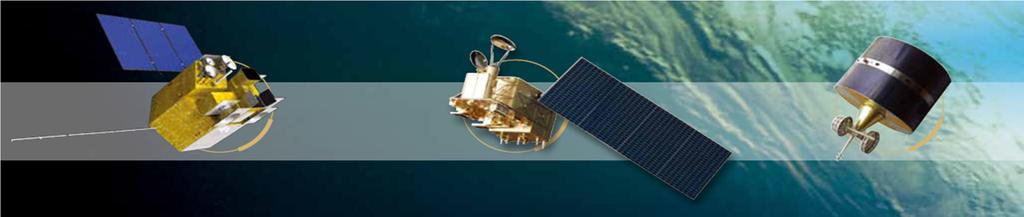


1 Sand and Dust Monitoring in RA II Xiang Fang National Satellite Meteorological Center,CMA
2 Outline Major progresses in 2015 Plan for Next Two Years on Dust monitoring
3 Major progress in 2015 AODretrievalfromHimawari-8(H8) Publishandsharedustproductsbasedonwebsite Establishthelong-termsatellitedustdataset Applicationinregionaldustforecastmodel
4 AOD retrieval from Himawari-8 Development of products from Himawari 8/9 AHI Increased Observation Spectral Bands VIS: 1 --> 3 NIR/IR : 4 --> 13 with Higher Resolution Spatial: 1km --> 0.5km for a VIS channel 4km --> 2 km for IR channels Temporal: 1 hr --> 10 min for a full disk scan 2.5min for limited areas.. will Enhance Baseline DAY-1 Products, especially - Atmospheric Motion Vectors (AMVs) - Cloud Properties - Aerosol (Dust) / Volcanic Ash Severe Weather Monitoring/ Nowcasting Volcano Eruption Volcanic Ash detection Numerical Prediction Yellow Sand/ Dust Storm Climate Monitoring/Diagnostics Solar Irradiance Monitoring
 products based on satellite data are used by the Japan Meteorological Agency (JMA) to monitor dust events in East Asia A new AOD algorithm for Himawari-8")
5 Himawari-8 AOD by JMA/MSC Himawari-8 AOD retrieved by JMA/MSC for 04 UTC 17 October Aerosol optical depth (AOD) products based on satellite data are used by the Japan Meteorological Agency (JMA) to monitor dust events in East Asia A new AOD algorithm for Himawari-8 developed by JMA s Meteorological Research Institute (MRI) has been introduced into JMA/MSC (Uesawa, 2016).


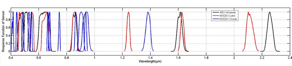
6 Table 1 Wavelength of Sensors including Himawari, FY-4A, GOES-R, MODIS Channel Himawari Spatial resolution Channel FY-4A Channel GOES-R Channel MODIS km ~ ~ km ~ km ~ ~ km ~ ~ ~ ~ km ~ ~ km 6 2.1~ ~ km ~4.0(High); 3.5~4.0(Low) * ~3.989(High); 3.929~3.989(Low) km 9 5.8~ ~ km km ~ ~ km ~9.0* ~ km ~ km ~11.3* km ~12.5* ~ km km ~13.8* ~13.485


7 CMA AOD products using Himawari-8 as proxy data Key Pionts: Surface albedo Aerosol Types Fig. Flowchart of aerosol retrieval over land Fig. Uncertainties in the retrieved surface albedo and AOD
 distribution of China at")
 distribution of JingJinJi region")
")
8 CMA AOD product (FY-4 algorithm) using Himawari-8 as proxy data Spatial resolution: 10 km AOD (550nm) distribution of China at 04:30 UTC in RGB image at 04:30 UTC in AOD (550nm) distribution of JingJinJi region at 04:30 UTC in (spatial resolution: 10 km) AOD (550nm) distribution of JingJinJi region at 04:30 UTC in (spatial resolution: 2 km)

9 A heavy pollution case in Northern China Fig. AOD distribution map of H8 from 00:00 UTC to 07:30 UTC in Dec 20, 2015 Himawari-8 can catch the distribution of the haze very well.


10 Compared CMA AOD with JMA /JAXA 0530 UTC JMA/JAXA CMA Fig AOD product of Himawari-8 from different aerosol retrieval algorithm at 05:30 UTC in Dec 20, 2015 JAXA CMA Himawari-8 can catch the distribution of the haze very well. JMA AOD product missed the heavy pollution of Northern China.
 from 01:30 UTC to 06:30 UTC in Dec 20, 2015 The AOD product from JMA/JAXA is smaller than the product from CMA.")
11 Compared CMA H8 AOD with JMA/JAXA Compared H8 AOD product (CMA) with AERONET Fig AOD product of Himawari-8 from JAXA and NSMC/CMA from 0130 UTC to 0630 UTC in Dec 20, 2015 Fig Comparison AOD product between Himawari and AERONET(BeiJing) from 01:30 UTC to 06:30 UTC in Dec 20, 2015 The AOD product from JMA/JAXA is smaller than the product from CMA. When the solar zenith is large, the AOD product of is obviously smaller than AERONET AOD. Aerosol retrieval algorithm still need to be improved!


12 Compare H8 AOD product with MODIS Terra Terra Aqua Aqua Fig AOD product from Terra/MODIS, Aqua/MODIS and H8 in Dec 20, 2015
13 Compared H8 AOD product with MODIS CORR = 0.71 CORR = 0.85 Fig Compared AOD product of Himawari-8 with AQUA/MODIS The agreement between these two AOD products is very good, when compared H8 AOD product with MODIS. The correlation coefficients is 0.71 for JAXA and 0.85 for CMA in , which means AOD product of H8 over land with reasonable accuracy.
 (a) AOD product of H8 from NSMC")
 The spatial")
 Air quality classification product of H8 (d) pm2.")
14 Using satellite AOD to estimate ground-level PM2.5 Satellite-based PM2.5 AOD (The column intergration of the light extinction) (a) AOD product of H8 from NSMC (b) pm2.5 product (μg/m3) of H8 PM2.5 (measured close to the surface which is closely related to human health) The spatial distribution in (c) and (d) are well accordance! (c) Air quality classification product of H8 (d) pm2.5 (μg/m3) data from ground stations Fig satellite-based AOD, pm2.5, air quality classification and ground observation at 05:00 UTC in Dec 20, 2015


15 Publish and share dust products based on website Since the spring of 2015, the operational satellite dust products of CMA have been published in real time, based on the portal website constructed by theasiaregional CentreoftheWMOSDS-WAS( FY-2 IDDI FY-3 AOD FY-3 DST
16 Establish Historical database Historical database( ) based on CMA satellite dust products has been established, including coverage, area, frequency. Additional parameters will be added in the database, including aerosol parameters and underlying surface parameters, such as vegetation Index, snow cover and surface temperature. cumulated area of the dust from2006 to 2015(unit:10000km2) year cumulat ed area cumulated area of the dust from2006 to 2015 (unit:10000km2)
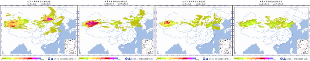
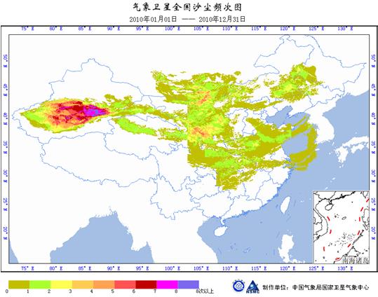
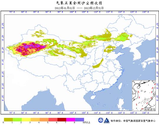
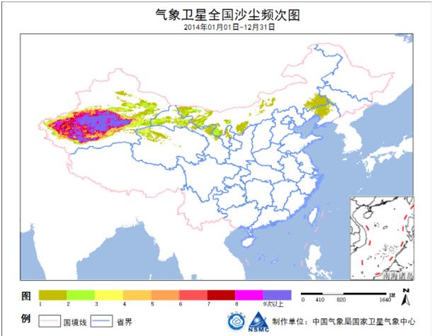
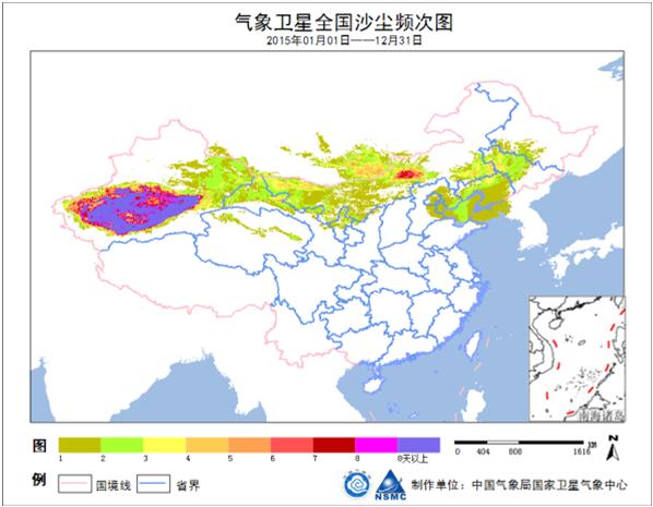
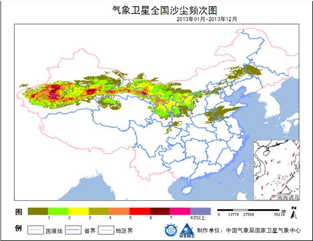
17 Dust Occurrence frequency during


18 Application in regional dust forecast model FY-2 IDDI can be assimilated into GRAPES-CUACE/Dust Model positive effect. It could provide 72 hours forecast results in Asian region as real-time services. With IDDI Without IDDI


19 Model products verification The ground-based observation data were assigned to their located grids and FY-2 IDDI were used in the grid without ground stations. A verification system has been developed for comparing the forecasting and observation data on each 1 1 grid. Products Verification (near-real time) DUST TS Scoring System Grid TS Scoring WMO SDS WAS AISA REGIONAL NODE Meeting, Seoul, Korea
20 Work plan in next stage Carryoutthespringexperimentofdustmonitoring usinghimawari-8data,andcomparethecma algorithmwithjmaalgorithm. GenerateFY-4AODproduct,andcompareitwith Himawri-8AODproductafterthelaunchofFY-4. Continuehazemonitoringbyusingsatellite products.
21 Plan for the Next Two Years on Dust Monitoring Standardization in dust concentration description Without a standardized practice in describing observed dust concentration among member countries, it will be difficult to monitor and forecast the transport of dust on a regional basis. It is necessary to establish unified standards to deal with observation methods and products for dust of various concentrations. Cross-verification of products from different satellites Now that several satellite systems are providing AOD products, for instance, FY- 3/MERSI, MTSAT-1/2, COMS/MI, Himawari-8, and FY-4/AGRI to be launched in near future, the cross-verification between different satellite products should be one of the issues to achieve consistency. Coupling the satellite and the surface observations Establish the relationship between the satellite-derived products and the surface-measured visibility, AOD,PM10, PM2.5, is important for validating the remote sensing products and for coupling the satellite and the surface observations.
22 Assimilating the satellite products into dust forecast models The initial value of dust forecast model is optimized using the satellite dust concentration and other data. This will improve the scientific basis for Asian dust storm forecasting in short term, medium, and long terms. Extending the application scope of satellite aerosol products Air pollution is becoming a serious hazard in East and South Asia. There is intention to extend the use of some dust and sand products, like AOD, AAI, for monitoring the haze pollution. Publishing and sharing information Each country would publish and share its own satellite dust products on unified website. Also, the methods of satellite products, product metadata are provided along with the user guidance, and necessary information for the support and training of the users. The website could be based on the portal website constructed by the Asia Regional Centre of the WMO Sand and Dust Storm Warning Advisory and Assessment System (SDS-WAS) (
23 Thanks for your attention!
GOCI Yonsei aerosol retrievals during 2012 DRAGON-NE Asia and 2015 MAPS-Seoul campaigns
 The Sixth Asia/Oceania Meteorological Satellite Users' Conference 09 13 November 2015, Tokyo/Japan GOCI Yonsei aerosol retrievals during 2012 DRAGON-NE Asia and 2015 MAPS-Seoul campaigns Myungje Choi (1),
IDEA for GOES-R ABI. Presented by S. Kondragunta, NESDIS/STAR. Team Members: R. Hoff and H. Zhang, UMBC
 IDEA for GOES-R ABI Presented by S. Kondragunta, NESDIS/STAR Team Members: R. Hoff and H. Zhang, UMBC 1 Project Summary Use operational MODIS, GOES Aerosol Optical Depth (AOD) products, and OMI/GOME-2
Optimizing data assimilation strategy for a global aerosol model with a multi-sensor constellation
 Optimizing data assimilation strategy for a global aerosol model with a multi-sensor constellation Edward Hyer, Peng Xian NRL Monterey, CA Jianglong Zhang University of North Dakota Grand Forks, ND American
Integrating remote sensing and ground monitoring data to improve estimation of PM 2.5 concentrations for chronic health studies
 Integrating remote sensing and ground monitoring data to improve estimation of PM 2.5 concentrations for chronic health studies Chris Paciorek and Yang Liu Departments of Biostatistics and Environmental
Supporting Information
 1 Supporting Information 2 3 4 5 6 7 8 9 10 11 12 Daily estimation of ground-level PM 2.5 concentrations over Beijing using 3 km resolution MODIS AOD Yuanyu Xie 1, Yuxuan Wang* 1,2,3, Kai Zhang 4, Wenhao
for air quality applications Edward Hyer Naval Research Laboratory AQAST Meeting Research Triangle Park, NC 16 November 2011
 Assimilation grade MODIS AOD for air quality applications Edward Hyer Naval Research Laboratory AQAST Meeting Research Triangle Park, NC 16 November 2011 Aerosol Data Assimilation for Air Quality Applications
Dust infrared aerosol properties observed from infrared hyperspectral sounders: Analysis of the diurnal variation
 Dust infrared aerosol properties observed from infrared hyperspectral sounders: Analysis of the diurnal variation V. Capelle 1, A. Chédin 1, M. Pondrom 1, R. Mechri C. Pierangelo 2, R. Armante 1, C. Crevoisier
Current Status of MICS-Asia III
 Current Status of MICS-Asia III Joshua S. Fu 1,2, Kan Huang 1, Zifa Wang 3, Jun-ichi Kurokawa 4 1 Department of Civil & Environmental Engineering The University of Tennessee, USA 2 Computer Science and
Solargis Report. Solar Resource Overview. Plataforma Solar de Almeria, Spain. 03 August Solargis s.r.o.
 Solargis Report Solar Resource Overview Site name: Plataforma Solar de Almeria, Spain Date of Issue: 03 August 2017 Type of Data: Daily time series (01/01/1994-31/12/2016) Customer: Solargis s.r.o. Issued
Solargis Report. Solar Resource Overview. Plataforma Solar de Almeria, Spain. 03 August Solargis s.r.o.
 Solargis Report Solar Resource Overview Site name: Plataforma Solar de Almeria, Spain Date of Issue: 03 August 2017 Type of Data: Hourly time series (01/01/1994-31/12/2016) TMY P50 (01/01/1994-31/12/2016)
Comparison of Aerosol Optical Depth (AOD) Derived from Ground-Based LIDAR and MODIS
 Derived from Ground-Based LIDAR and MODIS") The Open Atmospheric Science Journal, 9,, Open Access Comparison of Aerosol Optical Depth (AOD) Derived from Ground-Based LIDAR and MODIS P.W. Chan * Hong Kong Observatory, A Nathan Road, Hong Kong, China
The Open Atmospheric Science Journal, 9,, Open Access Comparison of Aerosol Optical Depth (AOD) Derived from Ground-Based LIDAR and MODIS P.W. Chan * Hong Kong Observatory, A Nathan Road, Hong Kong, China
AERONET Update. Brent Holben David Giles. ICAP Workshop October 22, 2014
 Principal Investigator: Brent Holben, NASA GSFC Instrumentation, Calibration & Maintenance: Mikhail Sorokin, Sigma Space Jon Rodriguez, Sigma Space Jason Kraft, Sigma Space Data Processing, Database, &
D. Trochkine, V. Pavlov, I. Sutorikhin, A. Romanov, N. Bezuglova, G. Zinchenko
 Seasonal change of water content in the atmosphere over the West Siberia on the basis of remote sensing using ENVISAT (ESA) D. Trochkine, V. Pavlov, I. Sutorikhin, A. Romanov, N. Bezuglova, G. Zinchenko
Response to RC2. We have added the following sentences in section 2.4 (lines 214 to 222):
:") Response to RC2 Concerning the introduction I am missing previous results of (UV-) MFRSR comparisons with other standard AOD measuring instruments. For example in the 2015 the Filter Radiometer comparison
Response to RC2 Concerning the introduction I am missing previous results of (UV-) MFRSR comparisons with other standard AOD measuring instruments. For example in the 2015 the Filter Radiometer comparison
Harvard University. Harvard University Biostatistics Working Paper Series
 Harvard University Harvard University Biostatistics Working Paper Series Year 00 Paper Spatio-temporal Associations Between GOES Aerosol Optical Depth Retrievals and Ground-Level PM. Christopher J. Paciorek
COAL FIRE QUANTIFICATION AND DETECTION USING THE DLR EXPERIMENTAL BI-SPECTRAL INFRARED DETECTION (BIRD) SMALL SATELLITE
 SMALL SATELLITE") COAL FIRE QUANTIFICATION AND DETECTION USING THE DLR EXPERIMENTAL BI-SPECTRAL INFRARED DETECTION (BIRD) SMALL SATELLITE Anke Tetzlaff a,b, Andreas Hirner a, Boris Zhukov a*, Claudia Kuenzer a and Stefan
COAL FIRE QUANTIFICATION AND DETECTION USING THE DLR EXPERIMENTAL BI-SPECTRAL INFRARED DETECTION (BIRD) SMALL SATELLITE Anke Tetzlaff a,b, Andreas Hirner a, Boris Zhukov a*, Claudia Kuenzer a and Stefan
Latest Updates and Research on Fire Radiative Energy Products
 Environmental Monitoring & Modelling Research Group Latest Updates and Research on Fire Radiative Energy Products Presented by Martin Wooster (Kings College London, UK) Wilfrid Schroeder (Univ. of Maryland,
Trend analysis of the aerosol optical depth from fusion of MISR and MODIS retrievals over China
 IOP Conference Series: Earth and Environmental Science OPEN ACCESS Trend analysis of the aerosol optical depth from fusion of MISR and MODIS retrievals over China To cite this article: Jing Guo et al 2014
Trans-boundary Ozone Pollution. A Global Chemical and Aerosol Data Assimilation Perspective. Brad Pierce NOAA/NESDIS
 Trans-boundary Ozone Pollution A Global Chemical and Aerosol Data Assimilation Perspective Brad Pierce NOAA/NESDIS Satellite Data Used in RAQMS Ozone Analysis The Ozone Monitoring Instrument (OMI) measures
A satellite view of global desert dust and primary carbonaceous aerosol emission database, Part: desert dust
 AEROCOM 16 TH WORKSHOP 16 th AEROCOM WORKSHOP Type: Oral Presentation October 9-13, 2017 Finnish Meteorological Institute, Helsinki, Finland A satellite view of global desert dust and primary carbonaceous
An analysis of the collection 5 MODIS over-ocean aerosol optical depth product for its implication in aerosol assimilation
 Atmos. Chem. Phys., 11, 557 565, 2011 doi:10.5194/acp-11-557-2011 Author(s) 2011. CC Attribution 3.0 License. Atmospheric Chemistry and Physics An analysis of the collection 5 MODIS over-ocean aerosol
Global Fire Emissions Database version 2 (GFEDv2) Released 21 December 2005
 Released 21 December 2005") Global Fire Emissions Database version 2 (GFEDv2) Released 21 December 2005 Keywords: biomass burning, fire, emissions, burned area, global, gridded, ascii, carbon, CO2, CO, CH4, NMHC, aerosols available
Global Fire Emissions Database version 2 (GFEDv2) Released 21 December 2005 Keywords: biomass burning, fire, emissions, burned area, global, gridded, ascii, carbon, CO2, CO, CH4, NMHC, aerosols available
Exploratory Use of Raster Images for Freight Modeling
 Exploratory Use of Raster Images for Freight Modeling Pedro Camargo PhD Student University of California, Irvine TRB SHRP2 SYMPOSIUM Innovations in Freight Demand Modeling and Data Improvement October
Past, Present-day and Future Ship Emissions
 Past, Present-day and Future Ship Emissions Veronika Eyring DLR-Institute of Atmospheric Physics How to make the sea green: What to do about air pollution and greenhouse gas emissions from maritime transport
On the improvement of MACC aerosol spatial resolution for irradiance estimation in the United Arab Emirates
 Available online at www.sciencedirect.com Energy Procedia 00 (2013) 000 000 www.elsevier.com/locate/procedia 2013 ISES Solar World Congress On the improvement of MACC aerosol spatial resolution for irradiance
National report of Japan (Submitted by Nobuyuki Shikama)
") Argo Steering Team Meeting, Hyderabad, India, January 16-18, 2006 National report of Japan (Submitted by Nobuyuki Shikama) 1. Status of implementation 1.1 Floats deployed and their performance Japan Agency
Argo Steering Team Meeting, Hyderabad, India, January 16-18, 2006 National report of Japan (Submitted by Nobuyuki Shikama) 1. Status of implementation 1.1 Floats deployed and their performance Japan Agency
Aerosol Optical Depth Retrieval by Neural Networks Ensemble with Adaptive Cost Function
 Aerosol Optical Depth Retrieval by eural etworks Ensemble with Adaptive Cost Function Vladan Radosavljevic, Slobodan Vucetic, Zoran Obradovic Center for Information Science and Technology, Temple University,
Measurements of trace gas emissions from biomass burning events detected at PEARL, Eureka, Nunavut, Canada, from 2007 to 2011
 Measurements of trace gas emissions from biomass burning events detected at PEARL, Eureka, Nunavut, Canada, from 2007 to 2011 IRWG/TCCON 2012 meeting Wengen, June 11 th Camille Viatte 1, R. Lindenmaier
METHODOLOGIES FOR CALCULATING ROAD TRAFFIC EMISSIONS IN MILAN
 METHODOLOGIES FOR CALCULATING ROAD TRAFFIC EMISSIONS IN MILAN FAIRMODE April 28 th, 2014 Marco Bedogni Mobility, Environment and Land Agency of Milan marco.bedogni@amat-mi.it WHO WE ARE The Mobility, Environment
Oil Palm Ripeness Detector (OPRID) and Non-Destructive Thermal Method of Palm Oil Quality Estimation
 and Non-Destructive Thermal Method of Palm Oil Quality Estimation") Oil Palm Ripeness Detector (OPRID) and Non-Destructive Thermal Method of Palm Oil Quality Estimation Abdul Rashid Mohamed Shariff, Shahrzad Zolfagharnassab, Alhadi Aiad H. Ben Dayaf, Goh Jia Quan, Adel
Oil Palm Ripeness Detector (OPRID) and Non-Destructive Thermal Method of Palm Oil Quality Estimation Abdul Rashid Mohamed Shariff, Shahrzad Zolfagharnassab, Alhadi Aiad H. Ben Dayaf, Goh Jia Quan, Adel
AERONET overview and Update of AEROENT V3 Products as it relates to 7-SEAS
 AERONET overview and Update of AEROENT V3 Products as it relates to 7-SEAS Brent HOLBEN, Thomas ECK, Aliaksandr SINYUK, Alexander SMIRNOV, David GILES, Ilya SLUTSKER, Joel SCHAFER, Mikhail SOROKIN, Si-Chee
Roadmap Data Update and Model Validation Documentation September 2017
 Roadmap Data Update and Model Validation Documentation September 2017 This document provides an overview of the updates that were made to the Roadmap model during the summer of 2017, and indicates the
Table S1 Figures S1 to S10
 Table S Figures S to S Table S. Comparison and inter-correlation between AeroCom I and AeroCom II individual models bias in simulating 27-29 CALIOP-derived Zα-6 km and AOD diagnostics over the 2 selected
Monitoring particulate pollution using GOCI COMS
 CEOS AC-VC Meeting 28-30 June, 2017, CNES, Paris Monitoring particulate pollution using GOCI COMS COMS/GOCI&MI Jhoon Kim 1, M. Choi 1, H. Lim 1, Tom Eck, Brent Holben, Zhengqiang Li 1 Yonsei University,
Integrated Flood Analysis System (IFAS)
") Global Flood Alert System (GFAS) Streamflow Integrated Flood Analysis System (IFAS) For local flood forecasting and warning using satellite-based rainfall and global GIS databases for poorly gauged basin
Global Flood Alert System (GFAS) Streamflow Integrated Flood Analysis System (IFAS) For local flood forecasting and warning using satellite-based rainfall and global GIS databases for poorly gauged basin
Atmospheric Chemistry and Physics. Interactive Comment. K. Kourtidis et al.
 Atmos. Chem. Phys. Discuss., www.atmos-chem-phys-discuss.net/15/c4860/2015/ Author(s) 2015. This work is distributed under the Creative Commons Attribute 3.0 License. Atmospheric Chemistry and Physics
IASI Conference Nov., 2007 Atlanthal Hotel Anglet, France
 MAIA Cloud Detection, IASI/AVHRR Cloud Clearing & Their Impact on Sounding Retrieval Allen Huang, Hong Zhang, Elisabeth Weisz, Hal Woolf & Jun Li Cooperative Institute for Meteorological Satellite Studies
European Aerosol Research Lidar Network: EARLINET
 European Aerosol Research Lidar Network: EARLINET Volker Matthias Max-Planck-Institut für Meteorologie, Bundesstraße 55, D-246 Hamburg, Germany Contents. EARLINET Objectives 2. Quality Assurance 3. Station
Spatial and temporal distribution of MODIS and MISR aerosol optical depth over northern China and comparison with AERONET
 Article Atmospheric Science July 2013 Vol.58 No.20: 2497 2506 doi: 10.1007/s11434-013-5678-5 Spatial and temporal distribution of MODIS and MISR aerosol optical depth over northern China and comparison
Deriving Background Concentrations of NOx and NO 2 April 2016 Update
 Deriving Background Concentrations of NOx and NO 2 April 2016 Update April 2016 Prepared by: Dr Ben Marner Approved by: Prof. Duncan Laxen 1 Calibration of DEFRA Background Maps 1.1 Background concentrations
Development of balloon-borne CO 2 sonde and test flight observations
 Development of balloon-borne CO 2 sonde and test flight observations 1 Y. Matsumi, M. Ouchi, T. Nakayama Solar Terrestrial Environment Laboratory, Nagoya University, Japan K. Shimizu, K. Shibata Meisei
A COMPARATIVE STUDY OF AEROSOL OPTICAL DEPTH OVER SINGAPORE FROM : RESULTS FROM AERONET AND MODIS DATA ANALYSIS.
 A COMPARATIVE STUDY OF AEROSOL OPTICAL DEPTH OVER SINGAPORE FROM 2007-2014: RESULTS FROM AERONET AND MODIS DATA ANALYSIS. Santo V. Salinas1, Astrid Muller2 and Tan Li1 Centre for Remote Imaging Sensing
FANG Shouen Tongji University
 Introduction to Dr. Fang Shou en Communist Party secretary of Tongji University; Doctoral supervisor in Tongji University; Executive director of China Intelligent Transportation Systems Association (CITSA)
FUEL ECONOMY BASELINE AND TRENDS- MALAWI INSTITUTIONS
 FUEL ECONOMY BASELINE AND TRENDS- MALAWI INSTITUTIONS Ministry of Natural Resources, Energy and Mining; Ministry of Transport and Public Works; University of Malawi; National Commission for Science and
Arabian Gulf Threats. 17 M barrels/ day, 35% of the world oil trade. Largest offshore oil development area in the world
 1 Arabian Gulf Threats 1. Ballast water discharged, 2. Dredging and infilling for coastal development, 3. Intentional or accidental oil spills, 4. Tank cleaning leakage from drilling rigs and production
BASELINE STUDY ON VEHICLE INVENTORY AND FUEL ECONOMY FOR MALAWI (KEY FINDINGS)
") BASELINE STUDY ON VEHICLE INVENTORY AND FUEL ECONOMY FOR MALAWI (KEY FINDINGS) TASK TEAM- LEAD INSTITUTION Ministry of Natural Resources, Energy and Mining Mount Soche Hotel, Blantyre. 11 th December 2017
BASELINE STUDY ON VEHICLE INVENTORY AND FUEL ECONOMY FOR MALAWI (KEY FINDINGS) TASK TEAM- LEAD INSTITUTION Ministry of Natural Resources, Energy and Mining Mount Soche Hotel, Blantyre. 11 th December 2017
TRAVEL DEMAND FORECASTS
 Jiangxi Ji an Sustainable Urban Transport Project (RRP PRC 45022) TRAVEL DEMAND FORECASTS A. Introduction 1. The purpose of the travel demand forecasts is to assess the impact of the project components
World Wide Watch. TECHNICAL NOTE for DESERT LOCUST product. Project partners: Contributing project: Last update: Page 1 of 8
 World Wide Watch TECHNICAL NOTE for DESERT LOCUST product Project partners: Contributing project: Last update: 2011-04-01 Page 1 of 8 PRODUCT TECHNICAL INFORMATION Format and compression: The products
Supporting Information
 Supporting Information van der Werf et al. 10.1073/pnas.0803375105 Fig. S1. Fire locations (number of detected fires during 2000 ) superimposed on a drainage map (blue). Note how most fires occur along
Aerosol Monitoring Site 4.0 (AMS 4.0)
") Aerosol Monitoring Site 4.0 (AMS 4.0) Development of Innovative Infrastructure for Aerosol Observation at Environmental Research Station Schneefernerhaus (UFS) Foto: IGUA / A. Philipp Project Group: Feasibility
Aerosol Monitoring Site 4.0 (AMS 4.0) Development of Innovative Infrastructure for Aerosol Observation at Environmental Research Station Schneefernerhaus (UFS) Foto: IGUA / A. Philipp Project Group: Feasibility
3. Atmospheric Supply of Nitrogen to the Baltic Sea in 2009
 3. Atmospheric Supply of Nitrogen to the Baltic Sea in 2009 Nitrogen emission data, as well as the model results presented here have been approved by the 35 th Session of the Steering Body of EMEP in Geneva
Holistic Range Prediction for Electric Vehicles
 Holistic Range Prediction for Electric Vehicles Stefan Köhler, FZI "apply & innovate 2014" 24.09.2014 S. Köhler, 29.09.2014 Outline Overview: Green Navigation Influences on Electric Range Simulation Toolchain
Supporting Information
 Supporting Information Estimating Ground-Level PM 2.5 in China Using Satellite Remote Sensing Zongwei Ma a, b, Xuefei Hu b, Lei Huang a, Jun Bi a,*, Yang Liu b,* a State Key Laboratory of Pollution Control
Georgia Pacific Crossett Operations Hydrogen Sulfide and Meteorological Monitoring Program
 Results you can rely on Georgia Pacific Crossett Operations Hydrogen Sulfide and Meteorological Monitoring Program 6-Month Report for October 1, 2014 through March 31, 2015 TRC Project Number: 222437.0000.0000
Sensitivity analysis of City Delta calculations for several Spanish cities
 33 rd meeting of the Task Force on Integrated Assessment Modelling 33 rd meeting of the Task Force on Integrated Assessment Modelling Sensitivity analysis of CD for Spain Prague. 3 May, 2007 National Integrated
Eye In The Sky: The Future of Risk Assessment From Above
 Eye In The Sky: The Future of Risk Assessment From Above Property Insurance Report National Conference 15 November 2010 Timothy E. Carone, Ph.D. Director, Global Climate Monitoring Systems Advanced Programs
Perspectivas y avances del uso de UAV en AP. Bruno Basso
 Perspectivas y avances del uso de UAV en AP Bruno Basso Outline of the presentation Remote and proximal sensing Pro and Cons of UAV Available UAVs Technologies Applications of UAVs in Precision Agriculture
GRID Structure Based Processing of Geographical and Environment Data
 GRID Structure Based Processing of Geographical and Environment Data Dorian Gorgan, Cornelia Melenti Computer Science Department Technical University of Cluj-Napoca dorian.gorgan@cs.utcluj.ro, cornelia.melenti@cs.utcluj.ro
AERONET Version 3 Database Update
 AERONET Version 3 Database Update David Giles 1,2, Brent Holben 2, Alexander Smirnov 1,2, Thomas Eck 2,3, Ilya Slutsker 1,2, Mikhail Sorokin 1,2, Joel Schafer 1,2, and Aliaksandr Sinyuk 1,2 1 Science Systems
Fine particle pollution
 www.pca.state.mn.us Fine particle pollution Fine particle pollution is a complex mixture of extremely small particles and liquid droplets that are created during combustion and can also be formed as other
Cleaning Up the Global On- Road Diesel Fleet. A Global Strategy to Introduce Low-Sulfur Fuels and Cleaner Diesel Vehicles
 Cleaning Up the Global On- Road Diesel Fleet A Global Strategy to Introduce Low-Sulfur Fuels and Cleaner Diesel Vehicles The Global Strategy and HDDI MTP Slide 2 The Initiative s objective is to virtually
CORINE Title Land Cover. First name SURNAME György BÜTTNER Position Senior advisor
 CORINE Title Land Cover First name SURNAME György BÜTTNER Position Senior advisor Name EEA/ IDM4 of the entity Place, Copenhagen, date 19/10/2015 Outline CLC basics Geographic coverage of CLC2012 Methodology
Heavy-Duty Vehicle Efficiency Global status and current research
 Heavy-Duty Vehicle Efficiency Global status and current research Oscar Delgado, Senior Researcher GFEI Fuel Economy State of the World Jan 11 2016 Outline Relevance of HDVs and status of regulations ICCT
In Conversation with: Vivian Balakrishnan, Singapore s Minister for the Environment and Water Resources (MEWR)
") November 2014 In Conversation with: Vivian Balakrishnan, Singapore s Minister for the Environment and Water Resources (MEWR) This issue of In Conversation with features Dr Vivian Balakrishnan, Singapore
November 2014 In Conversation with: Vivian Balakrishnan, Singapore s Minister for the Environment and Water Resources (MEWR) This issue of In Conversation with features Dr Vivian Balakrishnan, Singapore
Tackling Transport Emissions National information hub to support local action
 Tackling Transport Emissions National information hub to support local action Snapshot 2 Dec 2014 THIS REPORT provides an overview of the use and currently available content on the Low Emission Hub as
The European Commission s science and knowledge service
 The European Commission s science and knowledge service Joint Research Centre Optimal allocation of electric vehicle charging infrastructure in cities and regions Andreea Maria Julea, Harald Scholz, Christian
Dynamic Map Development in SIP-adus
 ITS World Congress in Melbourne 2016 SIS26 Digital Infrastructure for Automated Vehicles : challenges and international collaboration Dynamic Map Development in SIP-adus Cross-Ministerial Strategic Innovation
A DIAGNOSTIC MAINTENANCE SYSTEM FOR COMMERICIAL AND NAVAL VESSELS JANE CULLUM
 A DIAGNOSTIC MAINTENANCE SYSTEM FOR COMMERICIAL AND NAVAL VESSELS JANE CULLUM jane.cullum@utas.edu.au SUPERVISORS: Associate Professor Jonathan Binns, Professor Kiril Tenekedjiev, Dr. Rouzbeh Abbassi,
Application of EMME3 and Transportation Tomorrow Survey (TTS) for Estimation of Zonal Time Varying Population Density Distribution in
 for Estimation of Zonal Time Varying Population Density Distribution in") Application of EMME3 and Transportation Tomorrow Survey (TTS) for Estimation of Zonal Time Varying Population Density Distribution in the Greater Toronto Area Prepared by: Matthew Roorda, Associate Professor
Application of EMME3 and Transportation Tomorrow Survey (TTS) for Estimation of Zonal Time Varying Population Density Distribution in the Greater Toronto Area Prepared by: Matthew Roorda, Associate Professor
Long-Term Monitoring of Aerosols and Cloud Properties using Unmanned Aerial Vehicles (UAVs)
") Long-Term Monitoring of Aerosols and Cloud Properties using Unmanned Aerial Vehicles (UAVs) C. Keleshis, K. Neitola*, M. Pikridas, M. Argyrides, P. Vouterakos, P. Antoniou, C. Savvides, M. Vrekoussis,
Long-Term Monitoring of Aerosols and Cloud Properties using Unmanned Aerial Vehicles (UAVs) C. Keleshis, K. Neitola*, M. Pikridas, M. Argyrides, P. Vouterakos, P. Antoniou, C. Savvides, M. Vrekoussis,
Forest Fire NRT Emissions
 GMES Emissions WS, Copenhagen, 11 Oct 211 Kaiser, 1 Forest Fire NRT Emissions A GMES service provided by MACC Johannes W. Kaiser, A. Heil, M.G. Schultz, G. R. van der Werf, M.J. Wooster, W. Xu, and more
Habitat Associations of Seabirds and Marine Debris in the North East Pacific at Multiple Spatial Scales
 Habitat Associations of Seabirds and Marine Debris in the North East Pacific at Multiple Spatial Scales Andrew Titmus David Hyrenbach Hawaii Pacific University, Waimanalo, Hawaii Objectives Introduction
2012 Air Emissions Inventory
 SECTION 6 HEAVY-DUTY VEHICLES This section presents emissions estimates for the heavy-duty vehicles (HDV) source category, including source description (6.1), geographical delineation (6.2), data and information
Ambient PM 10 Monitoring Sechelt, B.C Update
 Ministry of Environment LOWER MAINLAND REGION Ambient PM 10 Monitoring Sechelt, B.C. 2004-2005 Update E N V I R O N M E N T A L Q U A L I T Y Library and Archives Canada Cataloguing in Publication Data
Evaluating opportunities for soot-free, low-carbon bus fleets in Brazil: São Paulo case study
 Evaluating opportunities for soot-free, low-carbon bus fleets in Brazil: São Paulo case study Tim Dallmann International seminar Electric mobility in public bus transport: Challenges, benefits, and opportunities
Support for the revision of the CO 2 Regulation for light duty vehicles
 Support for the revision of the CO 2 Regulation for light duty vehicles and #3 for - No, Maarten Verbeek, Jordy Spreen ICCT-workshop, Brussels, April 27, 2012 Objectives of projects Assist European Commission
Outline. Introduction to the downscaling approach GCM selection SST bias correction CCAM model features Climate Projections for Vietnam
 Outline Introduction to the downscaling approach GCM selection SST bias correction CCAM model features Climate Projections for Vietnam Rationale: why do we need more detail? Understand the likely effects
A LES/RANS HYBRID SIMULATION OF CANOPY FLOWS
 BBAA VI International Colloquium on: Bluff Bodies Aerodynamics & Applications Milano, Italy, July, - 8 A ES/RANS HYBRID SIMUATION OF CANOPY FOWS Satoru Iizuka and Hiroaki Kondo Nagoya University Furo-cho,
New Zealand Transport Outlook. VKT/Vehicle Numbers Model. November 2017
 New Zealand Transport Outlook VKT/Vehicle Numbers Model November 2017 Short name VKT/Vehicle Numbers Model Purpose of the model The VKT/Vehicle Numbers Model projects New Zealand s vehicle-kilometres travelled
WHAT WE WILL DISCUSS IN THIS VIDEO
 WHAT WE WILL DISCUSS IN THIS VIDEO What is Chandrayaan 2 all about? Why is it special? Have we entered the The Asian space race? Where do China, Japan and India stand? What is the importance of the moon?
Shipping Emissions and Air Quality Impacts in East Asia
 Shipping Emissions and Air Quality Impacts in East Asia Huan Liu, Ph.D, Assoc. Prof. Tsinghua University, liu_env@tsinghua.edu.cn Prepared for Shipping and the environment - From regional to global perspectives,
scoring Stefan Kinne model performance Stefan Kinne MPI-Meteorology MPI-Meteorology, Hamburg Hamburg, Germany
 scoring model performance Stefan Kinne Stefan Kinne MPI-Meteorology MPI-Meteorology, Hamburg Hamburg, Germany why scoring? initial thoughts (1) deficiencies in current model assessments subjective: model
WLTP DHC subgroup. Draft methodology to develop WLTP drive cycle
 WLTP DHC subgroup Date 30/10/09 Title Working paper number Draft methodology to develop WLTP drive cycle WLTP-DHC-02-05 1.0. Introduction This paper sets out the methodology that will be used to generate
OPEN HARDWARE, LOW COST, AIR QUALITY STATIONS FOR MONITORING OZONE IN COASTAL AREA
 EGU 214 - Atmospheric and Meteorological Instrumentation 4/28/214 OPEN HARDWARE, LOW COST, AIR QUALIT STATIONS FOR MONITORING OZONE IN COASTAL AREA Marco Lima Co-authors: Davide Donzella, Fabio Pintus,
TRIANGULO ALIMENTOS LTDA
 Particulars About Your Organisation Organisation Name TRIANGULO ALIMENTOS LTDA Corporate Website Address www.trianguloalimentos.com.br Primary Activity or Product Processor and/or Trader Related Company(ies)
Notes on Soot Measurement of Diesel Engines Wolfgang Schindler Wolfgang Singer
 Notes on Soot Measurement of Diesel Engines Wolfgang Schindler Wolfgang Singer AVL List GmbH, Graz, Austria Why bother about Soot Measurement? HC Oil cond. HC Fuel cond. Soot C Water Metal & Others Gravimetric
Supplement of Model simulations of cooking organic aerosol (COA) over the UK using estimates of emissions based on measurements at two sites in London
 over the UK using estimates of emissions based on measurements at two sites in London") Supplement of Atmos. Chem. Phys., 1, 13773 13789, 1 http://www.atmos-chem-phys.net/1/13773/1/ doi:1.19/acp-1-13773-1-supplement Author(s) 1. CC Attribution 3. License. Supplement of Model simulations of
Supplement of Atmos. Chem. Phys., 1, 13773 13789, 1 http://www.atmos-chem-phys.net/1/13773/1/ doi:1.19/acp-1-13773-1-supplement Author(s) 1. CC Attribution 3. License. Supplement of Model simulations of
SUBSIDIARY BODY FOR SCIENTIFIC AND TECHNOLOGICAL ADVICE Fourteenth session Bonn, July 2001 Item 3 (b) of the provisional agenda
 of the provisional agenda") UNITED NATIONS Distr. GENERAL 11 July 2001 ENGLISH ONLY SUBSIDIARY BODY FOR SCIENTIFIC AND TECHNOLOGICAL ADVICE Fourteenth session Bonn, 16-27 July 2001 Item 3 (b) of the provisional agenda REPORTS ON
UNITED NATIONS Distr. GENERAL 11 July 2001 ENGLISH ONLY SUBSIDIARY BODY FOR SCIENTIFIC AND TECHNOLOGICAL ADVICE Fourteenth session Bonn, 16-27 July 2001 Item 3 (b) of the provisional agenda REPORTS ON
Grid Impacts of Variable Generation at High Penetration Levels
 Grid Impacts of Variable Generation at High Penetration Levels Dr. Lawrence Jones Vice President Regulatory Affairs, Policy & Industry Relations Alstom Grid, North America ESMAP Training Program The World
EV market trends and outlook Shift Up a Gear
 EV market trends and outlook Shift Up a Gear Colin McKerracher Head of Advanced Transport Bloomberg New Energy Finance @colinmckerrache September 6, 2017 Analysis to help you understand the future of energy
Methane to Markets Partnership Expo. Remote Sensing - Aerial Leak Detection and Measurement. ANGEL Service Airborne Natural Gas Emission Lidar
 Methane to Markets Partnership Expo. Remote Sensing - Aerial Leak Detection and Measurement ANGEL Service Airborne Natural Gas Emission Lidar Wednesday, October 31, 2007 Daniel Brake Director, ANGEL Service
Projections of global emissions of air pollutants
 M. Amann, J. Cofala, Z. Klimont International Institute for Applied Systems Analysis (IIASA) Projections of global emissions of air pollutants TFHT Workshop on Emission Inventories and Projections Beijing,
Stop Sign Gap Assistance At Rural Expressway Intersections
 Stop Sign Gap Assistance At Rural Expressway Intersections Minnesota Department of Transportation University of Minnesota Outline What is Stop Sign Gap Assistance? Part of Multi-State Effort Crash Data
Draft Project Deliverables: Policy Implications and Technical Basis
 Surveillance and Monitoring Program (SAMP) Joe LeClaire, PhD Richard Meyerhoff, PhD Rick Chappell, PhD Hannah Erbele Don Schroeder, PE February 25, 2016 Draft Project Deliverables: Policy Implications
Low Carbon Green Growth Roadmap for Asia and the Pacific FACT SHEET
 Smart grid Low Carbon Green Growth Roadmap for Asia and the Pacific FACT SHEET Key point The smart grid allows small- and medium-scale suppliers and individuals to generate and distribute power in addition
Preface... xi. A Word to the Practitioner... xi The Organization of the Book... xi Required Software... xii Accessing the Supplementary Content...
 Contents Preface... xi A Word to the Practitioner... xi The Organization of the Book... xi Required Software... xii Accessing the Supplementary Content... xii Chapter 1 Introducing Partial Least Squares...
National Road Safety Action Plan in China
 Sixth SHRP 2 Safety Research Symposium National Road Safety Action Plan in China Dr. Yan Wang July 14, 2011 Washington DC, USA Outline 1 Initiative of Road Safety Action Plan 2 Phase I 3 For Next Phase?
Safe, comfortable and eco-friendly, Smart Connected Society
 Safe, comfortable and eco-friendly, Smart Connected Society Big data Traffic Management Centre Traffic Management for CASE Telematics Centre Energy Management for EV mrong-way detection Safety Support
Traffic Emission Inventory for Hanoi, Vietnam
 International Workshop on Air Quality in Asia Inventory, Modeling and Climate Impacts of Greenhouse Gas emissions (GHG s) and Aerosols; Remote sensing applications and Integrated Technologies Traffic Emission
Fluke 438-II Power Quality and Motor Analyzer
 Test Equipment Depot - 800.517.8431-99 Washington Street Melrose, MA 02176 - TestEquipmentDepot.com TECHNICAL DATA Fluke 438-II Power Quality and Motor Analyzer Quickly and easily discover electrical and