Utilizing GIS Models in Prioritizing and Selecting Transportation Projects
|
|
|
- Phillip McBride
- 5 years ago
- Views:
Transcription
1 Utilizing GIS Models in Prioritizing and Selecting Transportation Projects GIS-T Conference Raleigh, NC April 7, 2016 Tyler Meyer, AICP Tram Truong, GISP
2 Outline Case Studies: 1. MPO project selection for the Transportation Alternatives Program (TAP) 2. Sidewalk project prioritization
3 Case Study 1: Transportation Alternatives Program TAP program successor to Transportation Enhancements TAP program includes funding suballocated to 200,000+ UZA MPOs TAP requires a call for projects & competitive selection process Process subject to FHWA review & approval; requires public input FAST Act makes some changes

4 TAP Rules & Eligibility


5 MPO Narrowed Project Eligibility MPO determined to consider 3 project types: 1. Bicycle Infrastructure 2. Pedestrian Infrastructure 3. Intersection Improvement

6 91 Sidewalk Projects 10 Trail Projects 234 Intersections

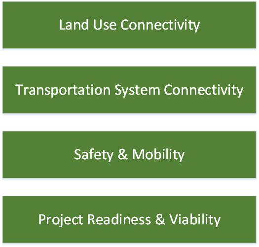
7 GIS Model
8 1. Land Use Connectivity Residential Area Employment/ Retail Center School Park or Recreation Center

9 1. Land Use Connectivity 8 points Network Analyst Pedestrian projects: 8 points ½ mile: 2 points 1 mile: 1 point Bicycle projects: 1 mile: 2 points 1 ½ mile: 1 point Intersection projects: ½ mile: 2 points 1 mile: 1 point
10 2. Transportation System Connectivity 1. Connect to transit service (2 Points) 2. Connect to other transportation modes and/or facilities (3 Points) 3. Connect to existing facility and fill a gap (2 Points) 4. Is the project in an area underserved by bicycle & pedestrian infrastructure? (3 Points) 5. Extend key parts of the regional greenway system (Bicentennial, Piedmont, A&Y, Downtown Greenway, Mountains to Sea Trail) (4 Points)

11 2.1 Transportation System Connectivity Transit Connection 2 points Network Analyst Pedestrian projects: ¼ mile: 2 points 2 points ½ mile: 1 point Bicycle projects: ½ mile: 2 points 1 mile: 1 point Intersection projects: ¼ mile: 2 points ½ mile: 1 point


12 2.2 Transportation System Connectivity In an area underserved Bike/Ped facility 3 points % of existing sidewalk over total length of sidewalk <25%: 3 points 24.4% 3 points >= 25 & <50%: 2 points >=50% & <75%: 1 point >=75%: 0 point

13 2.3 Transportation System Connectivity Connect to other transportation modes/ facilities 2 points Connect to 1 of these facilities: Bus stop 2 points Bike facility Sidewalk

14 2.4 Transportation System Connectivity Fill a gap 3 points Connect to same facility 3 points
15 2.5 Transportation System Connectivity Extend key trails 4 points Bicentennial Piedmont A&Y Downtown Greenway Mountains to Sea Trail
16 3. Safety & Mobility 1. Safety problem (3 Points) 2. Barrier to mobility (2 Points) 3. Improve mobility for disadvantaged populations (2 Points)

17 3.1 Safety & Mobility Safety problem 3 points Bike/ pedestrian crash: 3 points Other safety issues (crossing, light, 3 points etc.): 2 points


18 3.2 Safety & Mobility- Barrier to Mobility 2 point Fill a gap: 1 point % worker with no vehicle to work (over total worker in a census tract) >2.88%: 1 point Fill a gap: 1 point 3.49%: 1 point Total: 2 points


19 3.3 Safety & Mobility- Household Poverty 2 points % of household poverty: >= 26.44%: 2 points 14.62% 26.44%: 1 point <14.62%: 0 point 18.38%% 1 point
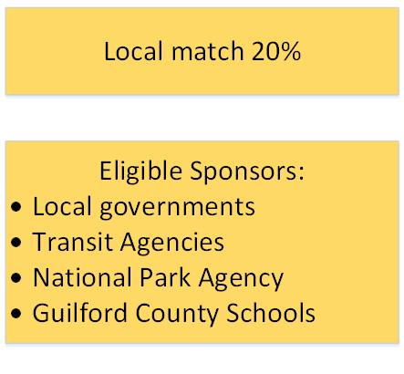
20 4. Project Readiness & Viability Meet funds obligation requirements in the funding availability timeframe (4 points) Part of an adopted plan (2 points) Local government support (2 points) Community/ public support (2 points) Document source for the required 20% match (2 points) ROW acquisition status (2 points)
21 GIS Model

22 91 Sidewalk Projects 10 Trail Projects
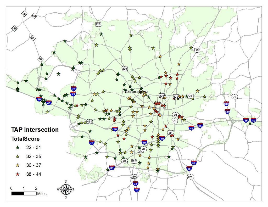
23 234 intersections
24 Results
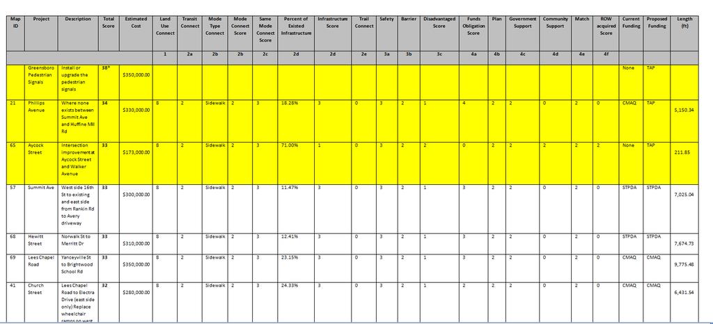
25 Project: Greensboro Pedestrian Signals Description: Install or upgrade the pedestrian signals Cost: $350,000 Total Score: 38 Current Funding: None Proposed Funding: TAP

26 Project 21: Phillips Ave Description: Where none exists between Summit Ave and Huffine Mill Rd Cost: $330,000 Total Score: 34 Land Use Connect 8 Percent of Existed Infrastructure 18.28% Disadvantaged Score 1 Match 2 Transit Connect Mode Type Connect Mode Connect Score Same Mode Connect Score 2 Infrastructure Score 3 Funds Obligation Score Sidewalk Trail Connect 0 Plan 2 2 Safety 3 3 Barrier 2 Government Support Community Support 4 2 ROW acquired Score Current Funding Proposed Funding 0 Length (ft) 0 CMAQ TAP 5,150.34

27 Project 65: Aycock / Walker Intersection Description: Intersection improvement at Aycock Street and Walker Avenue Cost: $173, Total Score: 33 Land Use Connect 8 Percent of Existed Infrastructure 71.00% Disadvantaged Score 2 Match 2 Transit Connect Mode Type Connect Mode Connect Score Same Mode Connect Score 2 Infrastructure Score 1 Funds Obligation Score Sidewalk Trail Connect 0 Plan 2 2 Safety 3 3 Barrier 2 Government Support Community Support 0 2 ROW acquired Score Current Funding Proposed Funding 2 Length (ft) 2 None TAP

28 Aycock Corridor & Intersection Project scope expanded following USDOT Safety Assessment Current Cost Estimate: $850,000
29 Case Study 1 Conclusions Automated GIS evaluation was useful Our attention to detail and testing during evaluation specification phase paid off GIS model produced valid results Top scoring projects realistically reflect top needs


30 Case Study 2: Prioritizing Sidewalk Sidewalk construction is an important local priority Currently miles of sidewalk in Greensboro miles of sidewalk added since miles of those miles built by road projects & 45 miles by independent sidewalk projects miles currently under design or construction
31 Manual Prioritization Methodology Staff developed a manual prioritization method based on Literature review Field experience City council guidance Data Roadway type, volume, speed Land use multifamily, commercial, school, park and recreation center Demand transit stop, path worn Connectivity filling gap Distribution across city
32 Manual Method Sidewalk Projects


 Field data")
33 Context for the GIS Model Input Data Input Criteria Scoring Prioritized Recommendation Land Use Connection Score Stakeholder Input Land Use Mixed Land Use Index Score Planners and managers review Selecting road segments with sidewalk needs Transit User Connectivity Socioeconomic Safety Top 50 Bus Stops by Ridership Score Transit Connection Score Trail Connection Score Sidewalk Gap Score Worker With No Vehicle Score Household Poverty Score Pedestrian Crash Score Total Score Prioritizing road segments with sidewalk needs using geographic equity into Tiers. Tier 1 has the highest score range and Tier 4 has the lowest score range. Tier 1: Short Term Tier 2: Middle Term Tier 3: Long Term Tier 4: Long Term (After Tier 3) Field data collection to collect current sidewalk presence and condition Street Classification Street Classification Score
34 Introduction Introduce 2-step sidewalk prioritization: Step 1: Address the needs Step 2: Geographic equity adjustment Validation: Compare results of Step 1 & Step 2 with: Test 1: Ratio of max and min of % sidewalk mileage by district Test 2: Manual planned sidewalk projects

35 Input Data Input Criteria Scoring Prioritized Recommendation Land Use Connection Score Stakeholder Input Land Use Mixed Land Use Index Score Planners and managers review Transit User Top 50 Bus Stops by Ridership Score Transit Connection Score Prioritizing road segments with sidewalk needs using geographic equity into Tiers. Connectivity Trail Connection Score Sidewalk Gap Score Total Score Tier 1 has the highest score range and Tier 4 has the lowest score range. Selecting road segments with sidewalk needs Socioeconomic Safety Worker With No Vehicle Score Household Poverty Score Pedestrian Crash Score Tier 1: Short Term Tier 2: Middle Term Tier 3: Long Term Tier 4: Long Term (After Tier 3) Field data collection to collect current sidewalk presence and condition Street Classification Street Classification Score
36 Methodology Step 1: Needs-based criteriacriteria Scoring Prioritized Step Scoring 2: Geographic Recommendation equity adjustment Land Use Connection Score Land Use Mixed Land Use Index Score Transit User Top 50 Bus Stops by Ridership Score Transit Connection Score Prioritizing road segments with sidewalk needs using geographic equity into Tiers. Connectivity Socioeconomic Trail Connection Score Sidewalk Gap Score Worker With No Vehicle Score Household Poverty Score Total Score Total Score Tier 1 has the highest score range and Tier 4 has the lowest score range. Tier 1: Short Term Tier 2: Middle Term Safety Pedestrian Crash Score Tier 3: Long Term Tier 4: Long Term (After Tier 3) Street Classification Street Classification Score
37 Land Use Transit User Land Use Connection Score Mixed Land Use Index Score Top 50 Bus Stops by Ridership Score Step 1: Needs-based criteria Transit Connection Score Connectivity Socioeconomic Trail Connection Score Sidewalk Gap Score Worker With No Vehicle Score Household Poverty Score Total Score Tier 1: points Tier 2: points Tier 3: points Tier 4: 9 16 points Safety Pedestrian Crash Score Street Classification Street Classification Score
38
39 Test 1: Percentage of Sidewalk mileage overall Roadway mileage by Tier by District District Score District 1 District 2 District 3 District 4 District 5 Max/ Min Tier Tier Tier Tier Unrated
40
41 Test 2: Number of short term planned sidewalk construction projects by tier by district District District 1 District 2 District 3 District 4 District 5 Total % Tier % Tier % Tier % Tier % Unrated %
42 Methodology Step 2: Geographic Equity Adjustment Adjusted priorities based on geographic equity Identify most needed project by city council districts Ensure that projects are sufficiently distributed throughout the city Avoid funding conflicts Avoid spotty and unconnected sidewalk development
43
44 Validation Test 1 Percentage of Sidewalk mileage overall Roadway mileage by Tier by District Tier 1 Tier 2 Tier 3 Tier 4 Unrated District District District District District Max/ Mean Min

45
46 Validation Test 2 Number of short term planned sidewalk construction projects by tier by district Tier 1 Tier 2 Tier 3 Tier 4 Unrated District District District District District Total %
47 Case Study 2 Conclusion Introduce 2-step prioritization method Identify most needed projects in all five districts, minimize funding conflicts between the districts, and reduce spotty and unconnected sidewalk development throughout the city Meet an acceptable validation target: 85% of planned sidewalk projects are in tier 1

48 Publication Plan: 2015 Bicycle, Pedestrian, Trails & Greenway Plan Update - Greensboro MPO Paper: TRB Accounting for Geographic Equity in Prioritizing Sidewalks
49 Big Picture Conclusions GIS automation helps a lot to systematically implement conceptual evaluation schemes GIS models can identify high need locations that are reasonably consistent with manual methods Thinking through criteria and weights is the most important part validation is important GIS models can eliminate a good bit of the work required for manual methods for sidewalk prioritization Even so, some manual interpretations & field work will always be needed on the back end
50 THANK YOU! Contact: Tyler Meyer, AICP Tram Truong, GISP
TRANSPORTATION PLANNING PERFORMANCE MEASUREMENT USING GIS
 TRANSPORTATION PLANNING PERFORMANCE MEASUREMENT USING GIS TYLER MEYER, AICP 2015 AMPO Conference Clark County, NV October 2015 Overview Transportation Alternatives Program (TAP) overview MPO TAP Scoring
BROWARD BOULEVARD CORRIDOR TRANSIT STUDY
 BROWARD BOULEVARD CORRIDOR TRANSIT STUDY FM # 42802411201 EXECUTIVE SUMMARY July 2012 GOBROWARD Broward Boulevard Corridor Transit Study FM # 42802411201 Executive Summary Prepared For: Ms. Khalilah Ffrench,
Parks and Transportation System Development Charge Methodology
 City of Sandy Parks and Transportation System Development Charge Methodology March, 2016 Background In order to implement a City Council goal the City of Sandy engaged FCS Group in January of 2015 to update
The Georgia CMAQ Program. Practice Makes Perfect
 The Georgia CMAQ Program Practice Makes Perfect Outline Georgia s Air Quality Georgia s CMAQ Process Prioritized Projects Project Mix Georgia and Air Quality Out of the 6 pollutants measured by EPA, Georgia
2030 Multimodal Transportation Study
 2030 Multimodal Transportation Study City of Jacksonville Planning and Development Department Prepared by Ghyabi & Associates April 29,2010 Introduction Presentation Components 1. Study Basis 2. Study
residents of data near walking. related to bicycling and Safety According available. available. 2.2 Land adopted by
 2. Assessment of Current Conditions and Needs In order to prepare a plan to reach the vision desired by the residents of Texarkana, it is first necessary to ascertain the current situation. Since there
Planning for Future Mobility In a Performance-Based World Steven Gayle, PTP
 Planning for Future Mobility In a Performance-Based World Steven Gayle, PTP September 26, 2018 MPOs at the Intersection 2 Performance-Based Planning New planning paradigm introduced in MAP-21 MPOs and
CEDAR AVENUE TRANSITWAY Implementation Plan Update
 CEDAR AVENUE TRANSITWAY Implementation Plan Update EECUTIVE SUMMARY DECEMBER 2015 Executive Summary In 2013, the Twin Cities metropolitan area s first bus rapid transit (BRT) line, the METRO Red Line,
US 81 Bypass of Chickasha Environmental Assessment Public Meeting
 US 81 Bypass of Chickasha Environmental Assessment Public Meeting March 14, 2013 Introductions ODOT FHWA SAIC Meeting Purpose Present need for bypass Provide responses to 10/04/11 public meeting comments
Waco Rapid Transit Corridor (RTC) Feasibility Study
 Feasibility Study") Waco Rapid Transit Corridor (RTC) Feasibility Study Chris Evilia, Director of Waco Metropolitan Planning Organization Allen Hunter, General Manager Waco Transit System Jimi Mitchell, Project Manager AECOM
Waco Rapid Transit Corridor (RTC) Feasibility Study Chris Evilia, Director of Waco Metropolitan Planning Organization Allen Hunter, General Manager Waco Transit System Jimi Mitchell, Project Manager AECOM
2016 PSRC REGIONAL & KING COUNTYWIDE EASTSIDE FUNDING AWARDS. Eastside Transportation Partnership September 9, 2016
 2016 PSRC REGIONAL & KING COUNTYWIDE EASTSIDE FUNDING AWARDS Eastside Transportation Partnership September 9, 2016 1 2 PSRC 2016 Project Selection Process 2018-2020 Estimated FHWA Funds Available: (Summary)
City of Pacific Grove
 Regional Study Utilizing Caltrans Intersection Evaluation Section 7: City of Pacific Grove s: FIRST STREET AT CENTRAL AVENUE Transportation Agency for Monterey County Prepared by Transportation Agency
Restoration of Historic Streetcar Services in Downtown Los Angeles
 Restoration of Historic Streetcar Services in Downtown Los Angeles Early Scoping Meeting for Alternatives Analysis (AA) May 17, 2011 Introduction Key players Local lead agency: Metro Federal lead agency:
Tulsa Transportation Management Area. Urbanized Area Surface Transportation Program
 Tulsa Transportation Management Area Urbanized Area Surface Transportation Program FFY 2022 Application Information Sponsor Location Description STP Request Other Funds Broken Arrow Elm Place: Kenosha
Restoration of Historic Streetcar Services in Downtown Los Angeles
 Restoration of Historic Streetcar Services in Downtown Los Angeles Alternatives Analysis Community Update Meeting August 2, 2011 Introduction Key players Local lead agency: Metro Federal lead agency: Federal
Needs and Community Characteristics
 Needs and Community Characteristics Anticipate Population and Job Growth in the City Strongest density of population and jobs in Ann Arbor are within the Study Area Population expected to grow 8.4% by
Metro Transit Update. Christina Morrison, Senior Planner Metro Transit BRT/Small Starts Project Office. John Dillery, Senior Transit Planner
 Metro Transit Update Christina Morrison, Senior Planner Metro Transit BRT/Small Starts Project Office John Dillery, Senior Transit Planner Metro Transit Service Development May 16, 2013 1 Transit Planning
Revised Evaluation Scores. System Preservation
 Revised Evaluation s System Preservation This page provides a summary of any revisions made to the draft scores presented at the October th Attributable Funds mmittee meeting. The information below highlights
5. OPPORTUNITIES AND NEXT STEPS
 5. OPPORTUNITIES AND NEXT STEPS When the METRO Green Line LRT begins operating in mid-2014, a strong emphasis will be placed on providing frequent connecting bus service with Green Line trains. Bus hours
FREQUENTLY ASKED QUESTIONS
 FREQUENTLY ASKED QUESTIONS 2018 What is the More MARTA Atlanta program? The More MARTA Atlanta program is a collaborative partnership between MARTA and the City of Atlanta to develop and implement a program
Community Advisory Committee. October 5, 2015
 Community Advisory Committee October 5, 2015 1 Today s Topics Hennepin County Community Works Update Project Ridership Estimates Technical Issue #4:Golden Valley Rd and Plymouth Ave Stations Technical
Dixie Transportation Planning Office
 A project must be given a yes rating on items 1 & 2 in order to be prioritized. Sponsor: St. George City Project: Pioneer Parkway Type: Road Widening and Reconstruction Rev. 9/17/2010 Dixie Transportation
To Infill or Not to Infill?
 To Infill or Not to Infill? Mark Fuhrmann Program Director, Rail New Starts Metropolitan Council/Metro Transit MarySue Abel Deputy Project Director, METRO Blue Line Extension Metropolitan Council/Metro
6/6/2018. June 7, Item #1 CITIZENS PARTICIPATION
 June 7, 2018 Item #1 CITIZENS PARTICIPATION 1 Item #2 APPROVAL OF MINUTES Item #3 TRAC GOALS, FRAMEWORK & AGENDA REVIEW 2 COMMITTEE GOALS Learn about Southern Nevada s mobility challenges, new developments
Chapter 7: Travel Demand Analysis. Chapter 8. Plan Scenarios. LaSalle Community Center. Image Credit: Town of LaSalle
 Chapter 7: Travel Demand Analysis Chapter 8 Plan Scenarios LaSalle Community Center. Image Credit: Town of LaSalle 164 Chapter 8: Plan Scenarios Moving Ahead for Progress in the 21 st Century Act (MAP
Kendall Drive Premium Transit PD&E Study Project Kick-Off Meeting SR 94/Kendall Drive/SW 88 Street Project Development and Environment (PD&E) Study
 Study") Florida Department of Transportation District Six Kendall Drive Premium Transit PD&E Study Project Kick-Off Meeting SR 94/Kendall Drive/SW 88 Street Project Development and Environment (PD&E) Study What
Florida Department of Transportation District Six Kendall Drive Premium Transit PD&E Study Project Kick-Off Meeting SR 94/Kendall Drive/SW 88 Street Project Development and Environment (PD&E) Study What
Fresno County. Sustainable Communities Strategy (SCS) Public Workshop
 Public Workshop") Fresno County Sustainable Communities Strategy (SCS) Public Workshop Project Background Senate Bill 375 Regional Transportation Plan (RTP) Greenhouse gas emission reduction through integrated transportation
Fresno County Sustainable Communities Strategy (SCS) Public Workshop Project Background Senate Bill 375 Regional Transportation Plan (RTP) Greenhouse gas emission reduction through integrated transportation
UTA Transportation Equity Study and Staff Analysis. Board Workshop January 6, 2018
 UTA Transportation Equity Study and Staff Analysis Board Workshop January 6, 2018 1 Executive Summary UTA ranks DART 6 th out of top 20 Transit Agencies in the country for ridership. UTA Study confirms
Hennepin County Transit Oriented Development Program. The Ellipse, St. Louis Park, 2009
 Hennepin County Transit Oriented Development Program The Ellipse, St. Louis Park, 2009 What is Transit Oriented Development (TOD)? Development within walking distance of transit Typically ¼ to ½ mile 10
SUPPORTING TOD IN METRO CHICAGO
 www.rtachicago.org SUPPORTING TOD IN METRO CHICAGO Tuesdays at APA November 18, 2014 OVERVIEW OF RTA 2 11/18/2014 Tuesdays at APA: Supporting TOD in Metro Chicago RTA Region 8.5 million people 3,700 square
Green Line Long-Term Investments
 Enhancements Short-term improvements to keep Austin moving. Investments Long-term projects to support our future. Mobility Hubs MetroRapid MetroRail MetroExpress Connectors Circulators Project Connect
TRAFFIC CALMING PROGRAM
 TRAFFIC CALMING PROGRAM PROGRAM BASICS Mount Pleasant Transportation Department 100 Ann Edwards Lane Mt. Pleasant, SC 29465 Tel: 843-856-3080 www.tompsc.com The Town of Mount Pleasant has adopted a traffic
King County Metro. Sustainably and equitably achieving a zero-emission fleet
 King County Metro Sustainably and equitably achieving a zero-emission fleet Agenda Background Purpose Service area Fleet size Climate goals Process Stakeholder engagement Analyses Service Equity Final
Sales and Use Transportation Tax Implementation Plan
 Sales and Use Transportation Tax Implementation Plan Transportation is more than just a way of getting from here to there. Reliable, safe transportation is necessary for commerce, economic development,
CITY OF ANN ARBOR, MICHIGAN 301 E. Huron St., P.O. Box 8647 Ann Arbor, Michigan
 Date: Wednesday, June 18, 2014 Location: Ann Arbor District Library Attendees: 14 citizen attendees Ann Arbor Station Environmental Review Citizen Working Group Meeting Notes Meeting #3 The third meeting
Tempe Streetcar. March 2, 2016
 Tempe Streetcar March 2, 2016 Tempe Profile 40 sq. miles, highest density in state University Town, center of region Imposed growth boundaries (density increase) Mixed use growth/intensifying land use
TRAVEL DEMAND FORECASTS
 Jiangxi Ji an Sustainable Urban Transport Project (RRP PRC 45022) TRAVEL DEMAND FORECASTS A. Introduction 1. The purpose of the travel demand forecasts is to assess the impact of the project components
Harrisburg Station Location Study. Allan Paul Deputy Director NCDOT Rail Division 9 th February 2015
 Harrisburg Station Location Study Allan Paul Deputy Director NCDOT Rail Division 9 th February 2015 NCDOT Rail Division Who We Are Six state-supported passenger trains Carolinian: Charlotte - Raleigh -
Subarea Study. Manning Avenue (CSAH 15) Corridor Management and Safety Improvement Project. Final Version 1. Washington County.
 Corridor Management and Safety Improvement Project. Final Version 1. Washington County.") Subarea Study Manning Avenue (CSAH 15) Corridor Management and Safety Improvement Project Final Version 1 Washington County June 12, 214 SRF No. 138141 Table of Contents Introduction... 1 Forecast Methodology
Subarea Study Manning Avenue (CSAH 15) Corridor Management and Safety Improvement Project Final Version 1 Washington County June 12, 214 SRF No. 138141 Table of Contents Introduction... 1 Forecast Methodology
Welcome. Green Line in Your Community
 Welcome Green Line in Your Community Today's session will provide you with information about Administration's recommendation for connecting the Green Line in the Beltline to Victoria Park and Inglewood/Ramsay
2030 Comprehensive Plan Goals, Objectives, and Policies Mobility Working Document
 TRANSPORTATION ELEMENT 2030 Comprehensive Plan Goals, Objectives, and Policies Mobility Working Document GOAL 1 The City shall utilize Quality/Level of Service standards which meet the Florida Department
TEXAS RURAL TRANSPORTATION PLAN 2035 (TRTP 2035)
") TEXAS RURAL TRANSPORTATION PLAN 2035 (TRTP 2035) Helping shape the future of rural Texas Texas Rural Transportation Plan 2035 Texas Rural Transportation Plan 2035 What is it? Component of the Statewide
TEXAS RURAL TRANSPORTATION PLAN 2035 (TRTP 2035) Helping shape the future of rural Texas Texas Rural Transportation Plan 2035 Texas Rural Transportation Plan 2035 What is it? Component of the Statewide
CITY OF ANN ARBOR, MICHIGAN 301 E. Huron St., P.O. Box 8647 Ann Arbor, Michigan
 Date: Wednesday, June 24, 2014 Location: Ann Arbor District Library Attendees: 40 citizen attendees Ann Arbor Station Environmental Review Public Meeting Meeting Notes Meeting #2 The second public meeting
SFY Call for Projects MPO Staff Recommendation All Projects Submitted for Funding Funds Available: $57,075,000
 SFY 2022-2023 Call for Projects MPO Staff Recommendation All Projects Submitted for Funding Funds Available: $57,075,000 DES NUM LPA PROJECT TITLE TYPE TOTAL SCORE FUND TYPE SFY FEDERAL COST LOCAL COST
Parking Management Element
 Parking Management Element The State Transportation Planning Rule, adopted in 1991, requires that the Metropolitan Planning Organization (MPO) area implement, through its member jurisdictions, a parking
West Broadway Reconstruction/LRT Design. March 19, 2015
 West Broadway Reconstruction/LRT Design March 19, 2015 1 Meeting Agenda 6:05 6:30 PM Brief presentation What we heard Project overview 6:30 8:00 PM Visit Six Topic Areas Road and LRT design elements Pedestrian
San Rafael Transit Center. Update. Golden Gate Bridge, Highway & Transportation District Transportation Committee of the Board of Directors
 Transportation Committee November 17, 2016 Agenda Item No. 5, Update on the San Rafael Transit Center Relocation San Rafael Transit Center Relocation Study Update 11/17/16 Golden Gate Bridge, Highway &
Executive Summary. Draft Environmental Impact Statement/Environmental Impact Report ES-1
 Executive Summary Introduction The Eastside Transit Corridor Phase 2 Project is a vital public transit infrastructure investment that would provide a transit connection to the existing Metro Gold Line
Midtown Corridor Alternatives Analysis. Policy Advisory Committee Meeting February 12, 2014
 Midtown Corridor Alternatives Analysis Policy Advisory Committee Meeting February 12, 2014 Today s Agenda Introductions Outreach efforts and survey results Other updates since last meeting Evaluation results
Williamson County Projects
 Williamson Projects SR-6/ US-31/ Franklin Road TIP # 2006-408 Road Widening TDOT Williamson Length 2.30 Regional Plan ID 1062-160 Air Quality Status Non-Exempt TDOT PIN 105717.00 $38,000,000.00 SR-31/Franklin
THE CITY OF CHATTANOOGA SMART TRANSPORTATION SYSTEMS
 THE CITY OF CHATTANOOGA SMART TRANSPORTATION SYSTEMS SMART TRANSPORTATION SYSTEMS What comes to mind when we mention the term Smart Transportation? or its more generic term ITS. (Intelligent Transportation
Metra Milwaukee District West Line Transit-Friendly Development Plan
 Metra Milwaukee District West Line Transit-Friendly Development Plan Community Input Workshop April 6, 2011 Overview of Presentation Workshop Goals Study Context Existing Conditions Market Overview Employment
An Introduction to Automated Vehicles
 An Introduction to Automated Vehicles Grant Zammit Operations Team Manager Office of Technical Services - Resource Center Federal Highway Administration at the Purdue Road School - Purdue University West
Geneva, 67th SC.2 Session October 2013 High Speed Trains Master Plan
 Geneva, 67th SC.2 Session 23 25 October 2013 High Speed Trains Master Plan Work Package I Work Package II Work Package III Project Management Review of related Work Socio economic framework of the ECE
Speaker Information Tweet about this presentation #TransitGIS
 Making the Case for Transit: the Transit Competitiveness Index Title William E. Walter, GISP Speaker Information Tweet about this presentation #TransitGIS Understanding Conditions in Each Travel Market
Letter EL652 City of Mercer Island. Page 1. No comments n/a
 Letter EL652 City of Mercer Island Page 1 No comments n/a Page 2 Response to comment EL652 1 Section 4.5.3 of the Final EIS presents the range of potential impacts of the project. This project also lists
Electric Vehicle Infrastructure Location Tool and Visualization Map. July 17, 2018
 Electric Vehicle Infrastructure Location Tool and Visualization Map Version 2.0 Analysis Summary July 17, 2018 Contents Electric Vehicle Fast Charging Infrastructure Planning Tools Overview & Analysis
MPO Staff Report Technical Advisory Committee: July 12, 2017
 MPO Staff Report Technical Advisory Committee: July 12, 2017 RECOMMENDED ACTION: 2 nd TAC Meeting with Kimley-Horn/WSB in Updating the Street/Highway Element of 2045 Metropolitan Transportation Plan. Matter
Rocky Mount. Transportation Plan. Transportation Planning Division. Virginia Department of Transportation
 2020 Transportation Plan Developed by the Transportation Planning Division of the Virginia Department of Transportation in cooperation with the U.S. Department of Transportation, Federal Highway Administration
METRO Light Rail Update
 American Society of Highway Engineers METRO Light Rail Update Brian Buchanan Director, Design and Construction October 13, 2009 1 High Capacity Transit System 2 20-Mile Light Rail Line 3 Operations Operations
Highway 18 BNSF Railroad Overpass Feasibility Study Craighead County. Executive Summary
 Highway 18 BNSF Railroad Overpass Feasibility Study Craighead County Executive Summary October 2014 Highway 18 BNSF Railroad Overpass Feasibility Study Craighead County Executive Summary October 2014 Prepared
LEED v4 Building Design and Construction Quiz #3 LT
 LEED v4 Building Design and Construction Quiz #3 LT 1. How are walking and bicycling distance measured? A. Straight-line radius from a main building entrance B. Straight-line radius from any building entrance
Green Line LRT: Beltline Segment Update April 19, 2017
 Green Line LRT: Beltline Segment Update April 19, 2017 Quick Facts On April 11, 2017, City Council approved Administration s recommendation for the Green Line to be underground in the Beltline from 2 Street
Reston Transportation Strategy July 9, 2018
 Reston Transportation Strategy July 9, 2018 Background: On February 11, 2014, the Board of Supervisors adopted the Reston Phase I Comprehensive Plan Amendment for the core areas of Reston between Sunset
Highway 23 New London Access & Safety Assessment. Public Open House #2 October 3, :00 to 7:00 PM
 Public Open House #2 October 3, 2017 5:00 to 7:00 PM Highway 9 OVERVIEW OF ASSESSMENT Assessment Limits Highway 23 from County Road 40 to North Shore Dr Purpose: Identify opportunities to reduce serious
Art Griffith, Capital Projects Manager, ,
 Part 1 Base Information 1. Project Title Broadway & Highlands Ranch Pkwy. Intersection Capacity and Safety Improvement Project 2. Project Start/End points or Geographic Area Provide a map with submittal,
Tier 2 Screening and Selection522. of the Short List Alternatives KISSIMMEE CORRIDOR. Downtown CRA. US 192 Alternatives Analysis
 LAKE COUNTY ORANGE COUNTY Ticket and Transportation Center Walt Disney / Reedy Creek Improvement District CR 535 John Young Parkway 441 17 92 Florida s Turnpike VE 92 mee Hall JOHN YOUNG PKY 192 OAK ST
DEVELOPMENT OF RIDERSHIP FORECASTS FOR THE SAN BERNARDINO INFRASTRUCTURE IMPROVEMENT STUDY
 APPENDIX 1 DEVELOPMENT OF RIDERSHIP FORECASTS FOR THE SAN BERNARDINO INFRASTRUCTURE IMPROVEMENT STUDY INTRODUCTION: This Appendix presents a general description of the analysis method used in forecasting
DRAFT Evaluation Scores. Transit
 DRAFT Evaluation s The criteria for evaluating applications for new funding commitments are used to measure how well they advance the six goals identified for the MTP. Through transportation: Reduce per
March 2, 2017 Integrating Transportation Planning, Project Development, and Project Programming
 COORDINATION WITH VDOT DISTRICTS TO DELIVER IMPLEMENTABLE IMPROVEMENT PROJECTS March 2, 2017 Integrating Transportation Planning, Project Development, and Project Programming PRESENTATION OUTLINE What
The City of Toronto s Transportation Strategy July 2007
 The City of Toronto s Transportation Strategy July 2007 Presentation Outline Transportation Statistics Transportation Building Blocks Toronto s Official Plan Transportation and City Building Vision Projects
WAKE TRANSIT PLAN Summer 2018
 WAKE TRANSIT PLAN Summer 2018 Planning for growth WAKE COUNTY s population already exceeds ONE MILLION and grows by more than 60 people a day. That s 23,000 people a year or basically another Morrisville.
State Avenue Corridor Bus Rapid Transit (BRT)
") State Avenue Corridor Bus Rapid Transit (BRT) Moving Forward Incrementally April 2010 State Ave. BRT Update Bus Rapid Transit Overview State Ave. Alternatives Analysis Results What s Coming Up Right Away!
State Avenue Corridor Bus Rapid Transit (BRT) Moving Forward Incrementally April 2010 State Ave. BRT Update Bus Rapid Transit Overview State Ave. Alternatives Analysis Results What s Coming Up Right Away!
Clearlake Road (State Road 501) Project Development & Environment (PD&E) Study
 Project Development & Environment (PD&E) Study") Clearlake Road (State Road 501) Project Development & Environment (PD&E) Study FROM MICHIGAN AVENUE TO INDUSTRY ROAD BREVARD COUNTY, FLORIDA Financial Project ID No: 433605-1-22-01 Federal Aid Project
Clearlake Road (State Road 501) Project Development & Environment (PD&E) Study FROM MICHIGAN AVENUE TO INDUSTRY ROAD BREVARD COUNTY, FLORIDA Financial Project ID No: 433605-1-22-01 Federal Aid Project
EXCEPTION TO STANDARDS REPORT
 EXCEPTION TO STANDARDS REPORT PROJECT DESCRIPTION AND NEED The project is located in Section 6, Township 23 North, Range 9 East and Section 31 Township 24 North, Range 9 East, in the Town of Stockton,
City of Marina. Regional Roundabout Study Utilizing Caltrans Intersection Control Evaluation Section 4: Transportation Agency for Monterey County
 Regional Roundabout Study Utilizing Caltrans Intersection Control Evaluation Section 4: City of Marina Study Intersections: RESERVATION ROAD AT BEACH ROAD RESERVATION ROAD AT DEFOREST ROAD CARDOZA AVENUE
Agenda. Utility Undergrounding Strategies & Laguna Canyon Road Master Plan
 Utility Undergrounding Strategies & Laguna Canyon Road Master Plan January 17, 2017 City Council Meeting 2 Agenda Progress since March 2016 Status of undergrounding and road widening between El Toro Rd.
Appendix C. Parking Strategies
 Appendix C. Parking Strategies Bremerton Parking Study Introduction & Project Scope Community concerns regarding parking impacts in Downtown Bremerton and the surrounding residential areas have existed
Arterial Bus Rapid Transit. System Policy Oversight Committee April 7, 2014
 Arterial Bus Rapid Transit System Policy Oversight Committee April 7, 2014 1 Meeting Agenda Welcome and Introductions A Line - Project Status Shelter and Pylon Development Arterial BRT Branding Update
Develop ground transportation improvements to make the Airport a multi-modal regional
 Project Overview TRANSPORTATION IMPROVEMENTS WHAT ARE THE PROJECT GOALS? Transportation transportation hub. Develop ground transportation improvements to make the Airport a multi-modal regional Land Use
Overview of Transit Funding and Planning in the PACTS Region
 Overview of Transit Funding and Planning in the PACTS Region Presentation to PACTS Transit Committee and Federal Transit Administration Representatives February 8, 2018 Transit Agencies Agency Communities
Major Widening/New Roadway
 Revised Evaluation s Major Widening/New Roadway This page provides a summary of any revisions made to the draft scores presented at the October th Attributable Funds Committee meeting. The information
Brainstormed Solutions - Passenger
 1-1a Air / Exand: Expand capacity (runway lengths) at BG airport (LOW) find solution! 1-1b Air / fuel: Improve fuel availabilty and reduce cost (LOW) Sound Walls X X X Reduce scatter lighting - more focused
CTA Blue Line Study Area
 CTA Blue Line Study Area HISTORY OF THE CTA BLUE LINE / I-290 SYSTEM Blue Line / I-290 infrastructure is 55 years old First integrated transit / highway facility in the U.S. PROJECT STUDY AREA EXISTING
MOTION NO. M Preferred Alternative for the Puyallup Station Access Improvement Project
 MOTION NO. M2014 64 Preferred Alternative for the Puyallup Station Access Improvement Project MEETING: DATE: TYPE OF ACTION: STAFF CONTACT: Capital Committee Board PROPOSED ACTION 8/14/14 8/28/14 Recommendation
Exhibit A Sound Transit Board Resolution R Selecting the bicycle, pedestrian, and parking access improvements to be built for the Puyallup
 Exhibit A Sound Transit Board Resolution R2016-07 Selecting the bicycle, pedestrian, and parking access improvements to be built for the Puyallup Access Improvement Project. RESOLUTION NO. R2016-07 Selecting
Transportation. Background. Transportation Planning Goals. Level of Service Analysis 5-1
 Transportation portion of the city s stormwater utility, and state road and fuel taxes. Background The transportation needs of the City of Lacey and its planning areas are met by a growing multimodal network
The Screening and Selection of Regionally Significant Projects
 The Screening and Selection of Regionally Significant Projects UTC 2018 Seminar Series March 15, 2018 Claire Bozic Martin Menninger ON TO 2050 CMAP is the Region s MPO, seven county region Land use and
Attachment 5. High Speed Transit Planning Study REPORT SUMMARY. Prepared by: City of Edmonton Transportation Planning Branch. Stantec Consulting Ltd.
 Attachment 5 High Speed Transit Planning Study Prepared by: City of Edmonton Transportation Planning Branch Stantec Consulting Ltd. Transportation Management & Design, Inc. with Lea Consulting Ltd. [135-35130]
City of Salem. Transportation Systems Development Charge Update
 Final Report City of Salem Transportation Systems Development Charge Update June 2, 2008 Public Works Department Transportation Services Division Transportation System Development Charge Update Project
TRAFFIC SIMULATION IN REGIONAL MODELING: APPLICATION TO THE INTERSTATEE INFRASTRUCTURE NEAR THE TOLEDO SEA PORT
 MICHIGAN OHIO UNIVERSITY TRANSPORTATION CENTER Alternate energy and system mobility to stimulate economic development. Report No: MIOH UTC TS41p1-2 2012-Final TRAFFIC SIMULATION IN REGIONAL MODELING: APPLICATION
Welcome The City has undertaken a naming exercise for the existing and future LRT lines. The SE to West LRT, as the project has been called to date,
 Welcome The City has undertaken a naming exercise for the existing and future LRT lines. The SE to West LRT, as the project has been called to date, is now called the Valley Line. We are here to present
DFW HSR Station Plans People Movers Hyperloop
 DFW HSR Station Plans People Movers Hyperloop Transit-Oriented Development Task Force Meeting May 1, 2018 Automated Transportation Systems (People Movers) Traditional People Movers Fixed, Closed Guideways
US 29 Bus Rapid Transit Planning Board Briefing. February 16, 2017
 US 29 Bus Rapid Transit Planning Board Briefing February 16, 2017 Project Goals Improve the quality of transit service Improve mobility opportunities and choices Enhance quality of life Support master
2018 Transportation Improvement Program (TIP) Bridge Section Summary of Proposed Changes July 24, 2018
 Bridge Section Summary of Proposed Changes July 24, 2018") Transportation Improvement Program (TIP) Bridge Section Summary of Proposed Changes July 24, FFY Section 2A State Prioritized Reliability s Bridge Program/On-System (NHS) Increase the Cost of Holyoke (600936)
Transportation Improvement Program (TIP) Bridge Section Summary of Proposed Changes July 24, FFY Section 2A State Prioritized Reliability s Bridge Program/On-System (NHS) Increase the Cost of Holyoke (600936)
January Final. Phase 2 Initial Screening Memorandum
 January 2018 Final Phase 2 Initial Screening Memorandum This page intentionally left blank Table of Contents 1. Introduction... 1 1.1 Project Area, Context, and Description... 1 1.2 Study Evaluation Process
COMMISSION WORKSHOP Tuesday, May 12, :00 a.m. 12:00 p.m.
 COMMISSION WORKSHOP Tuesday, 9:00 a.m. 12:00 p.m. AGENDA 1. Approval of the April 30, 2009 Workshop Minutes 2. Community Redevelopment Agency a. CRA Master Plan Update b. Downtown Parking Study 3. Economic
Call for Projects Congestion Mitigation and Air Quality (CMAQ) Emissions Formulas Technical Advisory Committee
 Emissions Formulas Technical Advisory Committee") Call for Projects Congestion Mitigation and Air Quality (CMAQ) Emissions Formulas Technical Advisory Committee July 18, 2018 Formula Coordination DRCOG under review, considering FHWA toolkit RAQC Argonne
Call for Projects Congestion Mitigation and Air Quality (CMAQ) Emissions Formulas Technical Advisory Committee July 18, 2018 Formula Coordination DRCOG under review, considering FHWA toolkit RAQC Argonne
2 MAJOR MACKENZIE DRIVE WEST JOG ELIMINATION AT HUNTINGTON ROAD CITY OF VAUGHAN
 2 MAJOR MACKENZIE DRIVE WEST JOG ELIMINATION AT HUNTINGTON ROAD CITY OF VAUGHAN The Transportation Services Committee recommends the adoption of the recommendations contained in the following report dated
Troost Corridor Transit Study
 Troost Corridor Transit Study May 23, 2007 Kansas City Area Transportation Authority Agenda Welcome Troost Corridor Planning Study Public participation What is MAX? Survey of Troost Riders Proposed Transit