2005 City of Santa Paula Potable Water System Master Plan Amendment
|
|
|
- Janis Todd
- 5 years ago
- Views:
Transcription

1 2005 City of Santa Paula Potable Water System Master Plan Amendment City of Santa Paula Project Engineer Randy Toedter, PE Brian Yanez June, Ventura Street Santa Paula, CA 93060
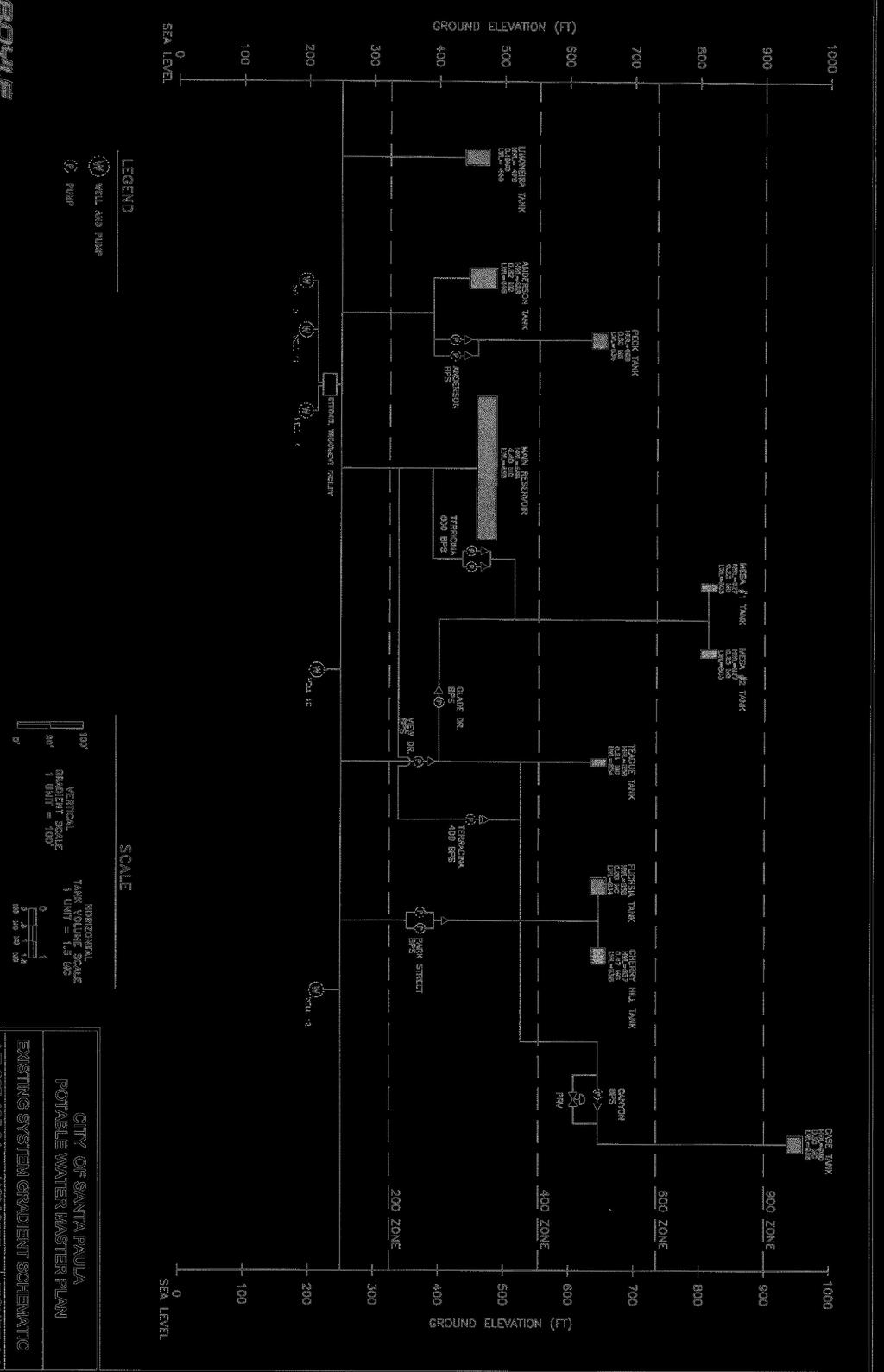
2 PURPOSE OF THE AMENDMENT The purpose of this Master Plan Amendment is to amend the exiting 2005 Potable Water System Master Plan to reflect updated East Area 1 and East Area 2 water system improvements. Because the approved City of Santa Paula Potable Water Master Plan no longer accurately reflects East Area 1 and 2 developments, this amendment was prepared to bring the Master Plan up-to-date. This amendment specifically addresses the East Area 1 and 2 improvements and how each development s potable water system will be integrated with the existing City infrastructure. This amendment contains text and graphics that have been revised from the approved 2005 Potable Water Master Plan. GENERAL DESCRIPTION The East Area 1 development is a 501-acre site that is located North of Highway 126, East of Santa Paula Creek and West of Orcutt Creek. The development is a mixture of residential, commercial, retail, open space and public facilities and includes a maximum buildout of 1,500 residential units, 150,000 square feet of light industrial uses, 285,000 square feet of commercial uses, 36.3 acres of civic/institutional uses, and various other land uses. The project will be built out in phases over a 10-year period with full build out to be completed in East Area 2 covers approximately 90 acres and is located directly to the south of East Area 1. East Area 2 will supplement the East Area 1 development to serve 340,000 SF of commercial buildings under the Santa Paula East Gateway Specific Plan as well other commercial and industrial uses. The amendment looks at each development s integration with the City s existing system, and does not include the analysis of East Area 1 and 2 s internal facilities. The developer has engaged the services of another engineering consultant to verify that internal distribution system and storage requirements meet City meets requirements put forth in the approved 2005 Master Plan. This information will be provided during the review of the Tentative Tract Maps and system design.
3 EAST AREA 1 AND EAST AREA 2 SYSTEM SUPPLY CONNECTIONS EXISTING CONDITION East Area 1 Currently, water supplies for the agricultural water uses of East Area 1 are derived from three or more on-site wells. These wells draw from the Santa Paula and Fillmore Groundwater Basins. The property owners have a combined on-site groundwater allocation of 1,283 AFY from the Santa Paula Basin and have historically withdrawn 329 AFY from the Fillmore Groundwater Basin. Therefore, combined groundwater sources available on-site for the East Area 1 development is approximately 1,612 AFY. East Area 2 Water supply to the East Area 2 area is supplied by the existing City of Santa Paula Water System. Currently, water usage in the existing developed East Area 2 site is estimated to be 63AF/yr. Some existing lines in the Ferris Lane area are currently 2 or smaller and known to be deficient. These lines would be upgraded to 6 or 8 pipes per the approved Master Plan. In the Hallock Drive Area, the existing lines are 10 AC with no deficiencies noted. Three farmers irrigation wells exist along the southern property line and will be accommodated in the ultimate East Area 2 build out so that the three wells can remain active. PROPOSED CONDITION Due to unknown timing of system wide upgrades to the City system, the City staff felt it prudent that the East Area 1 development contains a self-sufficient potable water system which required the sizing of tanks to meet the storage needs for the entire development. East Area 2 development will be served from the existing City water main in Hallock Drive and connected to the new tanks and distribution system of East Area 1. East Area 2 is currently a part of the City s 200-zone. The decision on which pressure zone will ultimately serve East Area 2 has not been determined. Storage tanks installed with the East Area 1 development will provide additional storage for the 200-zone system. The East Area 1 development will connect to the existing City system at two (2) locations: Hallock Drive and Telegraph Road intersection in the South and Santa Paula Street in the West. The Hallock Drive and Telegraph Road intersection will serve as the main point of connection (POC) for the project. A schematic of East Area 1 and East Area 2 s integration into the existing City system can be found on Figure A. The East Area 1 project was designed as a single zone water system capable of supplying all of East Area 1 and 2 s Maximum Daily Demand (MDD) with a new above-ground storage tank. Calculations of the East Area 1 and East Area 2 MDD were based off of demand factors in Table 3-10 of the approved Master Plan and can be found in Table I and Table 2, respectively. A 3.0 MG tank has been sized to serve the East Area 1 development on its own, new 300-zone, in addition to the East Area 2 development located within the City s existing 200-zone.
4 Ultimately, the 3.0MG tank serving East Area 1 and 2 has a 0.41 MG surplus when operating on the recommended 18-hr basis. East Area 1 and 2 storage requirements can be found in Table III. In addition to the installation of the 3.0 MG tank, the development agreement for the East Area 1 development also requires a 2.0 MG tank be installed with the East Area 1 improvements. This tank will provide additional storage for the overall City system and for future developments outside of the East Area 1 vicinity. It will also provide increased water pressure within the existing City system. Both proposed tanks are set at a bottom elevation of 535. Therefore, water levels in the tank will create a new 300 pressure zone within East Area 1 that is independent of the City s system. Although no pump station will be needed to transfer water from East Area 1 to existing developments to the West of Santa Paula Creek, a pump station will be required to pump water from the existing City system to the East Area 1 development in the case that the storage tanks on the east side of Santa Paula Creek are shut down for maintenance. Figure B displays a general schematic of the integration of these tanks into the existing City system. Six wells will pump water from the East Area 1 project site. Two wells will be located near Haun Creek. The other four well will be located on the west side of the project, adjacent to Santa Paula Creek. Six standby wells will be constructed adjacent to each duty well. The two wells at the east end of the property will serve the East Area 1 development. The other four wells will serve as additional supply for the City s system. A schematic layout of the well field can be found in Figure C. Water pumped from wells east of the Santa Paula Creek is of good quality. At this time water treatment is not expected (except for disinfection to meet or exceed State Drinking Water Standards). Water quality will be monitored. In the case where treatment is required, water will be treated at well head systems or a central treatment facility, likely located at the southeast corner of the project. From there, water will be pumped to the storage tank locations throughout the City. The pump station will be located near the 12 th Street bridge in the southwest corner of the East Area 1, so wells along the Santa Paula Creek will not pump into the 300-zone but into the City s 200-zone. The minimum combined capacity of the wells needed to supply the East Area 1 MDD (sized for an 18-hour basis) is 1700 GPM. After the development of East Area 2, well capacity must increase by 150 GPM to serve increased water demands, therefore increasing the minimum well capacity to 1850 GPM. Each well within the system will be designed to operate between GPM, which greatly exceeds the required well capacity. The pump station capacity serving the 3.0 MG tank from the wells was analyzed assuming both wells have a minimum capacity of 1000 GPM (2000 GPM combined capacity). Estimates of East Area 1 and 2 combined pumping requirements can be found on Table III. It is recommended that during periods of peak demand, wells delivering water to the 3.0 MG tank be able to deliver 2,800 GPM.
5 EAST AREA 1 AND 2 EFFECTS ON EXISTING CITY INFRASTRUCTURE East Area 1 will function as its own self-sufficient water system, providing the required 2.59 MG of storage for the East Area 1 and 2 developments. The development of East Area 1 will provide extra storage for the City s 200-zone, allowing the City to increase availability of fire flows and pressures downstream of the tank. With the full build out of East Area 2 and the 2.0 MG tank, the system will hold a surplus if 2.41MG (assuming the recommended 18-hr basis), enabling increased flexibility in system operations.
6
7
8
9 PROPOSED LAND USE TABLE I EAST AREA ONE SUMMARY OF ULTIMATE DOMESTIC WATER LAND USES AND DEMANDS TOTAL UNITS Area (Acres) DEMAND RATES Annual AVERAGE DAILY Demand (AF) FLOW (GPM) MAXIMUM DAY DEMAND (GPM) (1.5*ADD) PEAK HOUR DEMAND (GPM) (2.7*MDD) Residential units Single Family Attached 266 units 163 gpd/person Single Family Detached 607 units 163 gpd/person Multifamily 627 units 163 gpd/person Light Industrial 150,000 sq. ft gal/sq.ft/yr Commercial 285,000 sq. ft. 15.1gal/sq.ft/yr Civic/Institutional Elementary School AFY/acre High School AFY/acre Postsecondary Education AFY/acre Shared Facilities AFY/acre Other Water Consumption Shared Athletic Fields AFY/acre Parks/Greenways AFY/acre Agricultural Preserve (irrigated) AFY/acre Open Space Preserve (not irrigated) 79.4 No water use TOTAL 1, [1] Demand is estimated at 3.75 residents per dwelling for Single Family Attached units and 3.50 residents per dwelling in bith Single Family Detached and Multifamimly Units. [2] Estimate of water demand for agricultural uses is based on use over the last five years required to irrigate336 acres of land under production (816.3 AFY/405 acres = 2012 AFY/acre)
10 TABLE II Development Area WATER DEMAND (AF/ac/yr) [2] AREA (AC)[1] ANNUAL DEMAND (AF/yr) [4] EXISTING USE EXISTING DEMAND (AF/yr) INCREASE IN ANNUAL DEMAND (AF/yr) A Undeveloped 0 65 B Undeveloped 0 4 C Light Industrial 16 0 D Undeveloped 0 52 E Residential/Light Industrial 10 2 F Light Industrial 14 0 G Light Industrial 5 0 H Light Industrial 2 0 I Industrial 10 0 J GPD/UNIT [2] 8 UNITS 5 Residential 5 0 TOTAL 123 NOTES: [1] Flows calculated based on gross acreage of Development Area [2] Based on 15gal/SF/yr obtained from approved 2005 City of Santa Paula Water Master Plan. TOTAL AVERAGE DAILY DEMAND (GPM)= Maximum Daily Demand (GPM), MDD = 1.5*ADD= Peak Hour Demand (GPM) = 2.7*MDD= 76 GPM GPM GPM
11 Minimum Tank Storage Capacity for East Area 1 and East Area 2 Developments TABLE III EAST AREA 1 Reservior HWL Flow (GPM) Fire Daily Reglatory Storage (Gal) Total Storage Required (MG) Duration (Hrs) Required Fire Storage (Gal) MDD (GPM)* 8 Hr Emergency Storage (Gal) 24 Hr Basis 18 Hr Basis 9 Hr Basis 24 Hr Basis 18 Hr Basis 9 Hr Basis Reccomended Storage (MG) Tank Capacity (MG) Surplus Capacity (MG) Basis of Reccomendation ,080, , , ,919 1,761, Hr Basis *Because 3.0MG tank will be sized for both East Area 1 and East Area 2, the MDD, TOTAL = (MDD, EA1 + MDD, EA2) Well Pump Station Capacity Required Flow for East Area 1 at MDD (GPM) Deficit For: Capacity For: Pump No. of Duty Pump No. Of Standy 18 Hr 9 Hr 24 Hr Station Pumps Capacity 1 24 Hr Basis 18 Hr Basis 12 Hr Basis 9 Hr Basis Reservior Basis 24 Hr GPM Pumps GPM GPM GPM 18 Hr GPM 9 Hr GPM Well # Well #1A Hr Basis yes yes no
FINAL UTILITY REPORT Eastcreek Farm Thornton, CO
 FINAL UTILITY REPORT Eastcreek Farm Thornton, CO October 14, 2016 JN: 13049 Prepared for: York 80, LLC 12460 1 st Street Eastelake, CO 80614 P: 303.457.2966 Prepared by: Jansen Strawn Consulting Engineers
CONCEPTUAL UTILITY REPORT FOR THE CANYONS PHASE 1 CITY OF CASTLE PINES, CO
 CONCEPTUAL UTILITY REPORT FOR THE CANYONS PHASE 1 CITY OF CASTLE PINES, CO PREPARED FOR: SHEA HOMES 9380 STATION ST., SUITE 600 LONE TREE, CO 80124 PHONE: 303-791-8180 CONTACT: RYAN MCDERMED PREPARED BY:
Traffic Impact Statement (TIS)
") Traffic Impact Statement (TIS) Vincentian PUDA Collier County, FL 10/18/2013 Prepared for: Global Properties of Naples Prepared by: Trebilcock Consulting Solutions, PA 2614 Tamiami Trail N, Suite 615 1205
Traffic Impact Statement (TIS) Vincentian PUDA Collier County, FL 10/18/2013 Prepared for: Global Properties of Naples Prepared by: Trebilcock Consulting Solutions, PA 2614 Tamiami Trail N, Suite 615 1205
STAFF REPORT # CHANGE OF ZONING
 STAFF REPORT #17-2000-0007 CHANGE OF ZONING PLANNING COMMISSION MEETING DATE: November 16, 2017 (Applicant Provided Materials / Traffic Study = Blue) 1. APPLICATION: A public hearing for an application
PUBLIC INFRASTRUCTURE PROJECTS
 PUBLIC INFRASTRUCTURE PROJECTS FM 664 / OVILLA ROAD WIDENING & IMPROVEMENTS FM 664 / OVILLA ROAD CONNECTS US 287 WITH I-45 (SOURCE: TEXAS DEPARTMENT OF TRANSPORTATION. 2016 FM 664 / OVILLA ROAD WIDENING
Proposed location of Camp Parkway Commerce Center. Vicinity map of Camp Parkway Commerce Center Southampton County, VA
 Proposed location of Camp Parkway Commerce Center Vicinity map of Camp Parkway Commerce Center Southampton County, VA Camp Parkway Commerce Center is a proposed distribution and industrial center to be
King Soopers #116 Thornton, Colorado
 Traffic Impact Study King Soopers #116 Thornton, Colorado Prepared for: Galloway & Company, Inc. T R A F F I C I M P A C T S T U D Y King Soopers #116 Thornton, Colorado Prepared for Galloway & Company
Environmental Assessment Derry Road and Argentia Road Intersection
 Air and Noise Study Environmental Assessment Derry Road and Argentia Road Intersection Project 11-4295 City of Mississauga, Region of Peel October 17, 2014 1 Region of Peel Environmental Assessment for
Appendix 5. Haymeadow Interim Traffic Analysis
 Appendix 5 Haymeadow Interim Traffic Analysis 20 MEMORANDUM To: From: Rick Pylman Gary Brooks Bill Fox Date: September 15, 2016 Project: Subject: Haymeadow Evaluation of interim access configuration Currently
Report Addendum. Terry Keller, SDDOT. Noise Study Technical Report I-29 from Tea Interchange to Skunk Creek Sioux Falls, South Dakota
 Report Addendum To: Terry Keller, SDDOT From: HDR Project: Noise Study Technical Report I-29 from Tea Interchange to Skunk Creek Sioux Falls, South Dakota cc: file Date: May 28, 2010; rev July 16, July
Volume 1 Traffic Impact Analysis Turtle Creek Boulevard Dallas, Texas. Kimley-Horn and Associates, Inc. Dallas, Texas.
 Volume 1 Traffic Impact Analysis 2727 Dallas, Texas June 18, 2018 Kimley-Horn and Associates, Inc. Dallas, Texas Project #064523000 Registered Firm F-928 Traffic Impact Analysis 2727 Dallas, Texas Prepared
Chapter 8.0 PROPOSED CAPITAL IMPROVEMENT PROGRAM
 Chapter 8.0 PROPOSED CAPITAL IMPROVEMENT PROGRAM This chapter presents the proposed Capital Improvement Program (CIP) for the District based on the findings of this Master Plan. The Master Plan primarily
This letter summarizes our observations, anticipated traffic changes, and conclusions.
 Mr. David Jorschumb Project Manager Boulder Valley School District Re: Review of proposed school access improvements at the Foothills Elementary School in Boulder Dear Mr. Jorschumb, At your request, the
Station Evaluation. Durham-Orange Light Rail Transit Project Spring 2012
 Station Evaluation Durham-Orange Light Rail Transit Project Spring 2012 Key Ingredients for Station Development Platform Designs UNC Hospitals Station The UNC Hospitals Station Option D would be the westerly
Town of Londonderry, New Hampshire NH Route 28 Western Segment Traffic Impact Fee Methodology
 Town of Londonderry, New Hampshire NH Route 28 Western Segment Traffic Impact Fee Methodology Prepared by the Londonderry Community Development Department Planning & Economic Development Division Based
INDUSTRIAL DEVELOPMENT SITE DLH PARCEL #34 +/ GROSS ACRES DLH PARCELS #114 & #115 +/ GROSS ACRES
 INDUSTRIAL DEVELOPMENT SITE DLH PARCEL #34 +/- 55.39 GROSS ACRES DLH PARCELS #114 & #115 +/- 133.36 GROSS ACRES YOUR GATEWAY TO GLOBAL DISTRIBUTION LANCASTER-HUTCHINS ROAD HUTCHINS, TEXAS DLH PARCEL #34
Downtown Lee s Summit Parking Study
 Downtown Lee s Summit Parking Study As part of the Downtown Lee s Summit Master Plan, a downtown parking and traffic study was completed by TranSystems Corporation in November 2003. The parking analysis
City of Surrey PLANNING & DEVELOPMENT REPORT File:
 City of Surrey PLANNING & DEVELOPMENT REPORT Planning Report Date: June 26, 2017 PROPOSAL: Development Variance Permit to vary the off-street parking requirement to permit placement of one portable classroom
Craig Scheffler, P.E., PTOE HNTB North Carolina, P.C. HNTB Project File: Subject
 TECHNICAL MEMORANDUM To Kumar Neppalli Traffic Engineering Manager Town of Chapel Hill From Craig Scheffler, P.E., PTOE HNTB North Carolina, P.C. Cc HNTB Project File: 38435 Subject Obey Creek TIS 2022
Escondido Marriott Hotel and Mixed-Use Condominium Project TRAFFIC IMPACT ANALYSIS REPORT
 Escondido Marriott Hotel and Mixed-Use Condominium Project TRAFFIC IMPACT ANALYSIS REPORT Prepared for Phelps Program Management 420 Sixth Avenue, Greeley, CO 80632 Prepared by 5050 Avenida Encinas, Suite
6.16 OFF-STREET PARKING AND LOADING REQUIREMENTS
 6.16 OFF-STREET PARKING AND LOADING REQUIREMENTS 6.16.1 Off-Street Parking Off-street parking and loading spaces shall be required for all land uses as set forth in this section. A. Minimum Parking Space
Highway 18 BNSF Railroad Overpass Feasibility Study Craighead County. Executive Summary
 Highway 18 BNSF Railroad Overpass Feasibility Study Craighead County Executive Summary October 2014 Highway 18 BNSF Railroad Overpass Feasibility Study Craighead County Executive Summary October 2014 Prepared
4/2/18 MP NORTHPOINT MALL GENERAL GROWTH PROPERTIES
 PHOTOGRAPH OF PIONEER PLACE, PORTLAND, OREGON APPLICATION FOR MASTER PLAN AMENDMENT CITY OF ALPHARETTA, GEORGIA Photograph of Pioneer Place, Portland, Oregon, showing exterior of a leasable office use
TABLE OF CONTENTS EXECUTIVE SUMMARY...1 INTRODUCTION...3 PROJECTED FUTURE GROWTH...3 ROADWAY IMPROVEMENT PROJECTS...4 POTENTIAL FUNDING SOURCES...
 Transportation Impact Fee Study September 2014 TABLE OF CONTENTS EXECUTIVE SUMMARY...1 INTRODUCTION...3 PROJECTED FUTURE GROWTH...3 ROADWAY IMPROVEMENT PROJECTS......4 POTENTIAL FUNDING SOURCES...7 PROPOSED
Re: Amend Sections and File No ZA Marcus Lotson, Development Services Planner
 Page 1 To: From: The Planning Commission MPC Staff Date: April 5, 2016 Subject: Re: Amend Sections 8-3082 and 8-3090 Marcus Lotson, Development Services Planner Issue: Proposed amendments to the zoning
EXHIBIT A EAST VALLEY WATER DISTRICT SCHEDULE OF WATER AND WASTEWATER RATES AND CHARGES
 EXHIBIT A EAST VALLEY WATER DISTRICT SCHEDULE OF WATER AND WASTEWATER RATES AND CHARGES UPDATED MAY 24, 2017 Table of Contents Section 1: Water Service Charges... 2 Monthly Water System Charge... 2 Commodity
DEVELOPMENT AGREEMENT APPLICATION MULTI-UNIT RESIDENTIAL DEVELOPMENT FOURTH STREET NEAR BEDFORD HIGHWAY SUBMITTED BY: LYDON LYNCH ARCHITECTS
 DEVELOPMENT AGREEMENT APPLICATION MULTI-UNIT RESIDENTIAL DEVELOPMENT FOURTH STREET NEAR BEDFORD HIGHWAY NOVEMBER 30, 2017 SUBMITTED BY: LYDON LYNCH ARCHITECTS TABLE OF CONTENTS LETTER OF INTRODUCTION PROJECT
November 1, Mr. Jafar Tabrizi President, Tabrizi Rugs 180 Bedford Highway. Traffic Impact Statement BH-1 and BH-2, Southgate Drive, Bedford, NS
 161-12598 Mr. Jafar Tabrizi President, Tabrizi Rugs 180 Bedford Highway Bedford, NS B4A 1C1 [Via Email: tabrizi@tabrizi.com] RE: Traffic Impact Statement Dear Mr. Tabrizi: Plans are being prepared for
DEVELOPMENT PROPERTY 1627 MAXIME STREET CITY OF OTTAWA TRANSPORTATION OVERVIEW. Prepared for: Subhas Bhargava. July 9, Overview_1.
 DEVELOPMENT PROPERTY 1627 MAXIME STREET CITY OF OTTAWA TRANSPORTATION OVERVIEW Prepared for: Subhas Bhargava July 9, 2015 115-620 Overview_1.doc D. J. Halpenny & Associates Ltd. Consulting Transportation
1. INTRODUCTION 2. PROJECT DESCRIPTION CUBES SELF-STORAGE MILL CREEK TRIP GENERATION COMPARISON
 CUBES SELF-STORAGE MILL CREEK TRIP GENERATION COMPARISON 1. INTRODUCTION This report summarizes traffic impacts of the proposed CUBES Self-Storage Mill Creek project in comparison to the traffic currently
Open House. Highway212. Meetings. Corridor Access Management, Safety & Phasing Plan. 5:30 to 6:30 p.m. - Southwest Corridor Transportation Coalition
 Welcome Meetings 5:30 to 6:30 p.m. - Southwest Corridor Transportation Coalition 6:30 to 8:00 p.m. - Open House Why is Highway 212 Project Important? Important Arterial Route Local Support Highway 212
APPENDIX VMT Evaluation
 APPENDIX 2.7-2 VMT Evaluation MEMORANDUM To: From: Mr. Jonathan Frankel New Urban West, Incorporated Chris Mendiara LLG, Engineers Date: May 19, 2017 LLG Ref: 3-16-2614 Subject: Villages VMT Evaluation
2.0 Development Driveways. Movin Out June 2017
 Movin Out June 2017 1.0 Introduction The proposed Movin Out development is a mixed use development in the northeast quadrant of the intersection of West Broadway and Fayette Avenue in the City of Madison.
TRAFFIC IMPACT ANALYSIS
 TRAFFIC IMPACT ANALYSIS Emerald Isle Commercial Development Prepared by SEPI Engineering & Construction Prepared for Ark Consulting Group, PLLC March 2016 I. Executive Summary A. Site Location The Emerald
CITY OF MURFREESBORO PLANNING COMMISSION AGENDA
 CITY OF MURFREESBORO PLANNING COMMISSION AGENDA City Hall, 111 W. Vine Street, Council Chambers February 5, 2014 Bob Lamb 7:00 PM Chairman 1. Call to order. 2. Determination of a quorum. 3. Public Hearings:
April 7, Mr. Blake Shutler Compass Homes Development LLC Summit Homes Construction, LLC PO Box 6539 Dillon, CO 80435
 Compass Homes Development LLC Summit Homes Construction, LLC PO Box 6539 Dillon, CO 80435 Re: Trip Generation Comparison West Hills Townhomes Keystone, Colorado FHU Reference No. 116388-01 Dear Mr. Shutler:
Table 1: Existing Trip Generation A.M. Peak Hour P.M. Peak Hour Land Use ITE Code Intensity Daily Total In Out Total In Out
 October 24, 218 Mr. Justin D. Bridges, AIA, LEED AP Davidson A+E 431 Indian Creek Parkway Overland Park, KS 6627 RE: Dear Mr. Bridges, Trip Generation Overland Park, Kansas As requested, Priority Engineers,
TRAFFIC PARKING ANALYSIS
 TRAFFIC PARKING ANALYSIS NAPA FLEA MARKET COUNTY OF NAPA Prepared for: Tom Harding Napa-Vallejo Flea Market 33 Kelly Road American Canyon, CA 9453 Prepared by: 166 Olympic Boulevard, Suite 21 Walnut Creek,
Big Easy RV & Boat Storage A Green Energy Project Jana Lane Wildomar, California
 Big Easy RV & Boat Storage A Green Energy Project 36215 Jana Lane Wildomar, California 1 PROJECT OVERVIEW Project Description The construction and operation of a solar generation facility consisting of
Revised Strategy for Downtown Parking
 Revised Strategy for Downtown Parking December 4, 2017 Council Workshop Presented by Jennifer McCoy, P.E., City Traffic Engineer City-Owned Parking Today 3,500 metered parking spaces Parking meters charge
HIGHWAY 28 FUNCTIONAL DESIGN
 HIGHWAY 28 FUNCTIONAL DESIGN PUBLIC OPEN HOUSE #1 WEDNESDAY, MARCH 12, 2014 Stantec Presenters: Brad Vander Heyden, Project Engineer Neal Cormack, Project Manager Dave Parker, Project Engineer Beth Thola,
RE: A Traffic Impact Statement for a proposed development on Quinpool Road
 James J. Copeland, P.Eng. GRIFFIN transportation group inc. 30 Bonny View Drive Fall River, NS B2T 1R2 May 31, 2018 Ellen O Hara, P.Eng. Project Engineer DesignPoint Engineering & Surveying Ltd. 200 Waterfront
Traffic Management Plan and Queuing Analysis Lakehill Preparatory School Z Hillside Drive, Dallas, TX October 27, 2015
 Traffic Management Plan and Queuing Analysis Lakehill Preparatory School Z145-235 2720 Hillside Drive, Dallas, TX October 27, 2015 Introduction: The Lakehill Preparatory School is located on the northeast
I-820 (East) Project Description. Fort Worth District. Reconstruct Southern I-820/SH 121 Interchange
 Project Description. Fort Worth District. Reconstruct Southern I-820/SH 121 Interchange") I-820 (East) Project Description Fort Worth District Reconstruct Southern I-820/SH 121 Interchange I-820 from approximately 2,000 feet north of Pipeline Road/Glenview Drive to approximately 3,200 feet
I-820 (East) Project Description Fort Worth District Reconstruct Southern I-820/SH 121 Interchange I-820 from approximately 2,000 feet north of Pipeline Road/Glenview Drive to approximately 3,200 feet
Santa Ana River Conservation and Conjunctive Use Program (SARCCUP) Decision-Support Model. DSM Summary PA-23 Committee Briefing January 26, 2017
 Decision-Support Model. DSM Summary PA-23 Committee Briefing January 26, 2017") Santa Ana River Conservation and Conjunctive Use Program (SARCCUP) Decision-Support Model DSM Summary PA-23 Committee Briefing January 26, 2017 Santa Ana River Conservation and Conjunctive Use Program
Santa Ana River Conservation and Conjunctive Use Program (SARCCUP) Decision-Support Model DSM Summary PA-23 Committee Briefing January 26, 2017 Santa Ana River Conservation and Conjunctive Use Program
ENVIRONMENTAL SETTING
 II. ENVIRONMENTAL SETTING A. OVERVIEW OF ENVIRONMENTAL SETTING This section provides a brief overview of the project site s regional and local setting. Additional descriptions of the environmental setting
11 October 12, 2011 Public Hearing APPLICANT:
 11 October 12, 2011 Public Hearing APPLICANT: CARING TRANSITIONS PROPERTY OWNER: HARDEE REALTY CORPORATION REQUEST: Conditional Use Permit (motor vehicle rental) STAFF PLANNER: Leslie Bonilla ADDRESS /
Crestmont Development Update 2017 AGM
 Crestmont Development Update 2017 AGM West Crestmont West Crestmont Will be built in phases finally reaching about 524 residential units. Rough grading for phases 9 & 10 already underway. First show home
Water Major Facilities
 Water Major Facilities Water Residential (Units per Acre) Water oversize Residential 2.0 or less $6,842 per unit All Areas except RT Ph 1,2 $1,342 per gross acre Residential 2.1 to 2.5 $6,842 per unit
LOTUS RANCH TRAFFIC IMPACT ANALYSIS. LLG Ref Senior Transportation Engineer & Charlene Sadiarin Transportation Engineer II
 TRAFFIC IMPACT ANALYSIS LOTUS RANCH El Centro, California July 31, 2015February 12, 2016 LLG Ref. 3-14-2392 Prepared by: KC Yellapu, P.E Senior Transportation Engineer & Charlene Sadiarin Transportation
TRAFFIC IMPACT STUDY DERRY GREEN CORPORATE BUSINESS PARK MILTON SECONDARY PLAN MODIFICATION
 TRAFFIC IMPACT STUDY DERRY GREEN CORPORATE BUSINESS PARK MILTON SECONDARY PLAN MODIFICATION TRAFFIC IMPACT STUDY DERRY GREEN CORPORATE BUSINESS PARK MILTON SECONDARY PLAN MODIFICATION DECEMBER 24 UPDATED
APPENDIX C-2. Traffic Study Supplemental Analysis Memo
 APPENDIX C-2 Traffic Study Supplemental Analysis Memo The Mobility Group Transportation Strategies & Solutions Memorandum To: From: Subject: Tomas Carranza, LADOT Matthew Simons Traffic Review - Revised
Traffic Impact Analysis. Alliance Cole Avenue Residential Site Dallas, Texas. Kimley-Horn and Associates, Inc. Dallas, Texas.
 Traffic Impact Analysis Alliance Cole Avenue Residential Site Dallas, Texas February 15, 2018 Kimley-Horn and Associates, Inc. Dallas, Texas Project #064524900 Registered Firm F-928 Traffic Impact Analysis
Cedar View Subdivision No. 2 Hillcrest Dr. Montrose, Colorado 81401
 Cedar View Subdivision No. 2 Hillcrest Dr. 81401 Property Information Packet John Renfrow * Jim Renfrow M b f Renfrow Realty Member of: Rocky Mountain Commercial Brokers www.rmcbrokers.com Page 1 Executive
THE CORNERSTONE APARTMENTS TRAFFIC IMPACT STUDY R&M PROJECT NO
 THE CORNERSTONE APARTMENTS SITUATED AT N/E/C OF STAUDERMAN AVENUE AND FOREST AVENUE VILLAGE OF LYNBROOK NASSAU COUNTY, NEW YORK TRAFFIC IMPACT STUDY R&M PROJECT NO. 2018-089 September 2018 50 Elm Street,
DRAFT TRANSPORTATION IMPACT STUDY CASTILIAN REDEVELOPMENT PROJECT
 DRAFT TRANSPORTATION IMPACT STUDY CASTILIAN REDEVELOPMENT PROJECT Prepared for: Submitted by: 299 Lava Ridge Ct. Suite 2 Roseville, CA. 95661 June 212 TABLE OF CONTENTS 1. Introduction... 1 Project Location
TRAFFIC IMPACT STUDY. USD #497 Warehouse and Bus Site
 TRAFFIC IMPACT STUDY for USD #497 Warehouse and Bus Site Prepared by: Jason Hoskinson, PE, PTOE BG Project No. 16-12L July 8, 216 145 Wakarusa Drive Lawrence, Kansas 6649 T: 785.749.4474 F: 785.749.734
Transportation & Traffic Engineering
 Transportation & Traffic Engineering 1) Project Description This report presents a summary of findings for a Traffic Impact Analysis (TIA) performed by A+ Engineering, Inc. for the Hill Country Family
BOARD OF SUPERVISORS BUSINESS MEETING ACTION ITEM. Design Endorsement for Sterling Boulevard Extension
 Date of Meeting: July 20, 2017 # 6 BOARD OF SUPERVISORS BUSINESS MEETING ACTION ITEM SUBJECT: ELECTION DISTRICT: CRITICAL ACTION DATE: STAFF CONTACTS: Design Endorsement for Sterling Boulevard Extension
5 June 12, 2013 Public Hearing APPLICANT: BARTON HERITAGE, LLC T/A SANDBRIDGE BEACH BUGGIES PROPERTY OWNER: LOWER 40, LLC
 REQUEST: Conditional Use Permit (motor vehicle rentals low speed vehicles) ADDRESS / DESCRIPTION: 3713 Sandpiper Road 5 June 12, 2013 Public Hearing APPLICANT: BARTON HERITAGE, LLC T/A SANDBRIDGE BEACH
EXECUTIVE SUMMARY. The following is an outline of the traffic analysis performed by Hales Engineering for the traffic conditions of this project.
 EXECUTIVE SUMMARY This study addresses the traffic impacts associated with the proposed Shopko redevelopment located in Sugarhouse, Utah. The Shopko redevelopment project is located between 1300 East and
ORANGE COUNTY TRAFFIC COMMITTEE. Speed Limit. Sellas Road North/Sellas Road South; Ladera Ranch; TB 952-F1. Traffic Engineering.
 ORANGE COUNTY TRAFFIC COMMITTEE SUPERVISORIAL DISTRICT: 5 SUBJECT: LOCATION: INITIATED BY: INVESTIGATOR: REQUEST: Speed Limit Sellas Road North/Sellas Road South; Ladera Ranch; TB 952-F1 Traffic Engineering
PRELIMINARY UTILITY REPORT FOR TOPGOLF INTERNATIONAL, INC.
 PRELIMINARY UTILITY REPORT FOR TOPGOLF INTERNATIONAL, INC. THORNTON, COLORADO Prepared for: ARCO Murray Contact: Rachel Bohac Phone: 331.251.2726 Prepared by: 1225 17 th Street, Suite 514 Denver, CO 80202
CITY PLANNING COMMISSION AGENDA
 Page 7 CONSENT CALENDAR CITY PLANNING COMMISSION AGENDA ITEM NO: A STAFF: LONNA THELEN FILE NO: CPC CU 13-00008 QUASI-JUDICIAL PROJECT: APPLICANT: OWNER: 1710 DUBLIN PAULSON ARCHITECTS, P.C. MICHAEL W
Construction Realty Co.
 MEMORANDUM TO: FROM : Jeff Pickus Construction Realty Co. Luay R. Aboona, PE Principal 9575 West Higgins Road, Suite 400 Rosemont, Illinois 60018 p: 847-518-9990 f: 847-518-9987 DATE: May 22, 2014 SUBJECT:
Transportation Land Development Environmental S e r v i c e s
 Transportation Land Development Environmental S e r v i c e s Memorandum To: Ms. Kristin E. Kassner Planning Director Town Hall Annex 25 Center Street Burlington, MA 01803 Date: September 23, 2013 Project
CHINO DESALTER PHASE 3
 CHINO DESALTER PHASE 3 Comprehensive Predesign Report Prepared for Jurupa Community Services District, City of Ontario, and Western Municipal Water District REVISED FINAL December 2010 Jurupa Community
Water Resources Planning Department. Projection Analysis Work Sheets for Willows District. Printed on 4/12/2016 at 4:04 PM
 Water Resources Planning Department Projection Analysis Work Sheets for Willows District 215 Printed on 4/12/216 at 4:4 PM Table of Contents for Worksheets Worksheet Title 1 Annual Services 2 Service Growth
TIMBERVINE TRANSPORTATION IMPACT STUDY FORT COLLINS, COLORADO JANUARY Prepared for:
 TIMBERVINE TRANSPORTATION IMPACT STUDY FORT COLLINS, COLORADO JANUARY 2014 Prepared for: Hartford Companies 1218 W. Ash Street Suite A Windsor, Co 80550 Prepared by: DELICH ASSOCIATES 2272 Glen Haven Drive
SOCIO-ECONOMIC and LAND USE DATA
 SOCIO-ECONOMIC and LAND USE DATA FUTURE CONDITIONS January CHATHAM URBAN TRANSPORTATION STUDY - 1 - Table of Contents Introduction 3 TAZ - Municipality - Map Index...8 2005 Socio-economic and Land Use
RESOLUTION NO NOW, THEREFORE, BE IT RESOLVED BY THE MAYOR AND COMMON COUNCIL OF THE TOWN OF PRESCOTT VALLEY, ARIZONA, AS FOLLOWS:
 RESOLUTION NO. 1873 A RESOLUTION OF THE MAYOR AND COMMON COUNCIL OF THE TOWN OF PRESCOTT VALLEY, A MUNICIPAL CORPORATION OF ARIZONA, APPROVING A PLAN, POLICY OR PROCEDURE IN ACCORDANCE WITH ARS 9-471(O)
Appendix E Water Supply Modeling
 Supply Modeling Modesto Irrigation District Treatment Plant Expansion Project Modeling I. Introduction The Modesto Irrigation District (MID) is situated adjacent to and north of the Tuolumne River. Over
II. PROJECT DESCRIPTION
 II. PROJECT DESCRIPTION A. PROJECT APPLICANT The project applicants for the proposed Sepulveda/Rosecrans Site Rezoning are: Mar Ventures, Inc., 2050 West 190 th Street, Suite 108, Torrance, California,
DFO STATEMENT OF NEED REPORT
 APPENDIX E DFO STATEMENT OF NEED REPORT Table of Contents 1.0 Executive Summary... 1 2.0 Description of the Area... 2 2.1 Geographic Study Area... 2 2.2 2016 System Configuration... 2 3.0 Area Loading
105 Toronto Street South, Markdale Transportation Impact Study. Paradigm Transportation Solutions Limited
 105 Toronto Street South, Markdale Transportation Impact Study Paradigm Transportation Solutions Limited December 2016 Project Summary Project Number 162060 December 2016 Client Zelinka Priamo Ltd 318
Background. Request for Decision. Pedestrian Lighting Standards for Road Right-of-ways. Recommendation. Presented: Monday, Mar 17, 2014
 Presented To: Operations Committee Request for Decision Pedestrian Lighting Standards for Road Right-of-ways Presented: Monday, Mar 17, 2014 Report Date Thursday, Mar 06, 2014 Type: Presentations Recommendation
Traffic Impact Study Proposed Residential Development (Watson Parkway North - Starwood Drive Node, City of Guelph)
") Traffic Impact Study Proposed Residential Development (Watson Parkway North - Starwood Drive Node, City of Guelph) Prepared By: 332 Lorne Avenue East Stratford ON N5A 6S4 Prepared for: Paul Kemper, President
Traffic Impact Study Proposed Residential Development (Watson Parkway North - Starwood Drive Node, City of Guelph) Prepared By: 332 Lorne Avenue East Stratford ON N5A 6S4 Prepared for: Paul Kemper, President
TRANSPORTATION REVIEW
 TRANSPORTATION REVIEW - PROPOSED MIX OF LAND USES IS CONSISTENT WITH THE CITY S UNDER THE GRANVILLE BRIDGE POLICIES THAT AIM TO MEET NEIGHBOURING RESIDENTS SHOPPING NEEDS AND REDUCE RELIANCE ON AUTOMOBILE
BARRHAVEN FELLOWSHIP CRC 3058 JOCKVALE ROAD OTTAWA, ONTARIO TRANSPORTATION BRIEF. Prepared for:
 BARRHAVEN FELLOWSHIP CRC 3058 JOCKVALE ROAD OTTAWA, ONTARIO TRANSPORTATION BRIEF Prepared for: Barrhaven Fellowship CRC 3058 Jockvale Road Ottawa, ON K2J 2W7 December 7, 2016 116-649 Report_1.doc D. J.
Bi-County Transitway/ Bethesda Station Access Demand Analysis
 Bi-County Transitway/ Bethesda Station Access Demand Analysis Prepared for: Washington Metropolitan Area Transit Authority Office of Planning and Project Development May 2005 Prepared by: in conjunction
/ Planning and Zoning Staff Report Lonestar Land, LLC. - Rezone, RZ
 / Planning and Zoning Staff Report Lonestar Land, LLC. - Rezone, RZ2018-0019 Hearing Date: October 18, 2018 Development Services Department Applicant: Lonestar Land, LLC. Representative: Lance Warnick
Parking and Loading. Page 1 of 7
 Parking and Loading 21.03.020 Off-street parking and loading. A. Purpose. The purpose of this section is to ensure that sufficient off-street parking and loading areas are provided and properly designed
A13 AVILA RANCH DEVELOPMENT PLAN SITE PLAN. Typical 58 R-1 Residential Street Section STREET SECTION. July 19, 2016 #
 STREET SECTION SITE PLAN Typical 58 R-1 Residential Street Section 0 4 8 16 SCALE: 1 =8 (24 x36 sheet) A13 STREET SECTION SITE PLAN Typical 60 Collector Street Section 0 4 8 16 SCALE: 1 =8 (24 x36 sheet)
STH 60 Northern Reliever Route Feasibility Study Report
 #233087 v3 STH 60 Northern Reliever Route Feasibility Study Report Washington County Public Works Committee Meeting September 28, 2016 1 STH 60 Northern Reliever Route Feasibility Study Hartford Area Development
Subarea Study. Manning Avenue (CSAH 15) Corridor Management and Safety Improvement Project. Final Version 1. Washington County.
 Corridor Management and Safety Improvement Project. Final Version 1. Washington County.") Subarea Study Manning Avenue (CSAH 15) Corridor Management and Safety Improvement Project Final Version 1 Washington County June 12, 214 SRF No. 138141 Table of Contents Introduction... 1 Forecast Methodology
Subarea Study Manning Avenue (CSAH 15) Corridor Management and Safety Improvement Project Final Version 1 Washington County June 12, 214 SRF No. 138141 Table of Contents Introduction... 1 Forecast Methodology
NAVY YARD BALLPARK STATION ACCESS IMPROVEMENTS STUDY. Final Report. Washington Metropolitan Area Transit Authority
 NAVY YARD BALLPARK STATION ACCESS IMPROVEMENTS STUDY Final Report Washington Metropolitan Area Transit Authority Office of Real Estate and Station Planning April 2016 [This page intentionally left blank]
,ILLS CITY OF BEVERLY HILLS TRAFFIC AND PARKING COMMISSION. July 12, 2018 TO: Traffic and Parking Commission FROM: Transportation Staff SUBJECT:
 Transportation Staff TO: FROM: Traffic and Parking Commission July 12, 2018 A. Preferential Parking Permit Test District Survey and FAQ Sheet All businesses and households located within 1,000 feet of
ORIGINAL AND REVISED DEVELOPMENT CONCEPTS
 Reference No.: 141-24579 Mr. Tyson Simms, MCIP, LPP Planner II Rural Policy and Applications Current Planning Planning and Development P.O. Box 1749 Halifax, NS B3J 3A5 Re: : (WSP Canada Inc, March 2015)
CITY OF OMAHA OMAHA, NEBRASKA
 DOWNTOWN PARKING NEEDS ASSESSMENT UPDATE CITY OF OMAHA OMAHA, NEBRASKA Prepared for: City of Omaha Parking Division October 15, 2014 FINAL REPORT TABLE OF CONTENTS EXECUTIVE SUMMARY... 1 Study Purpose...
Alternatives Analysis Findings Report
 6.0 This chapter presents estimates of the potential capital, operations and maintenance costs associated with the alternatives carried forward for detailed evaluation. The methodology used to develop
MEMO 1. SITE LOCATION AND EXISTING USE. 2.1 Vehicle Access. Table 1: Vehicle Parking Requirements and Proposed Supply
 MEMO DATE: March 22, 2016 PROJECT O: 4241-44 PROJECT: 1550 Alberni Street SUBJECT: Transportation Design Rationale for Rezoning Application (Update with Design Package) TO: Dave Leung, 1550 Alberni Limited
TECHNICAL MEMORANDUM. Part A: Introduction
 TECHNICAL MEMORANDUM To: David J. Decker Decker Properties, Inc. 5950 Seminole Centre Ct. Suite 200 Madison, Wisconsin 53711 608-663-1218 Fax: 608-663-1226 www.klengineering.com From: Mike Scarmon, P.E.,
Access Management Standards
 Access Management Standards This section replaces Access Control Standards on Page number 300-4 of the Engineering Standards passed February 11, 2002 and is an abridged version of the Access Management
Public Information Workshop
 Public Information Workshop Charlotte County-Punta Gorda MPO - Meeting Rooms A and B March 29, 2018 Welcome to the Public Information Workshop for Harborview Road Project Development and Environment (PD&E)
Agenda Cover Memorandum
 Agenda Cover Memorandum Meeting Date: August 21, 2017 Meeting Type: COW (Committee of the Whole) City Council Budget Workshop Item Title: Final approval of an Ordinance amending various sections of Article
Municipal District of Taber Synchronized With The Alberta Township System
 Municipal District of Taber Synchronized With The Alberta Township System The Alberta Township System The Alberta Township System is another Name for the Dominion Land Survey System that was developed
Mercer Island Town Center Parking Study Joint Commission Presentation March 16, 2016
 Mercer Island Town Center Parking Study Joint Commission Presentation March 16, 2016 Mercer Island Town Center Parking Study Study Area Town Center Bordered by Sunset Way, Island Crest Way, SE 32 nd Street,
MONTEREY BAY AQUARIUM RESEARCH INSTITUTE (MBARI) MASTER PLAN UPDATE MOSS LANDING, CALIFORNIA
 MASTER PLAN UPDATE MOSS LANDING, CALIFORNIA") MONTEREY BAY AQUARIUM RESEARCH INSTITUTE (MBARI) MASTER PLAN UPDATE MOSS LANDING, CALIFORNIA TRAFFIC IMPACT ANALYSIS Administrative Draft Report Prepared For Monterey Bay Aquarium Research Institute Moss
MONTEREY BAY AQUARIUM RESEARCH INSTITUTE (MBARI) MASTER PLAN UPDATE MOSS LANDING, CALIFORNIA TRAFFIC IMPACT ANALYSIS Administrative Draft Report Prepared For Monterey Bay Aquarium Research Institute Moss
10 May 14, 2014 Public Hearing
 10 May 14, 2014 Public Hearing APPLICANT: PROPERTY OWNER: AEGEAN ASSOCIATES CUP-Truck and Trailer Rentals STAFF PLANNER: Kristine Gay REQUEST: Conditional Use Permit for Truck and Trailer Rentals ADDRESS
Wilson Blvd Center CPUD Amendment (Wilson Blvd & Golden Gate Blvd, Collier County, Florida)
") JMB TRANSPORTATiaN ENGINEERING, inc TRAFFIC/TRANSPDRTATION ENGINEERING &. PLANNING SERVICES TRAFFIC IMPACT STATEMENT For Wilson Blvd Center CPUD Amendment (Wilson Blvd & Golden Gate Blvd, Collier County,
JMB TRANSPORTATiaN ENGINEERING, inc TRAFFIC/TRANSPDRTATION ENGINEERING &. PLANNING SERVICES TRAFFIC IMPACT STATEMENT For Wilson Blvd Center CPUD Amendment (Wilson Blvd & Golden Gate Blvd, Collier County,