STREETS AND ROADS DESIGN MANUAL TABLE OF CONTENTS 1.0 GENERAL... S-1
|
|
|
- Ambrose Dalton
- 5 years ago
- Views:
Transcription
1
2 STREETS AND ROADS DESIGN MANUAL TABLE OF CONTENTS 1.0 GENERAL S Definitions S Responsibility for Design and Construction..... S Authorization Permits S Planning Guidelines S Existing Streets S DESIGN S Preliminary Considerations S Layout of Intersections S Horizontal Curves S Superelevation S Cul-de-Sacs; Tee Turn-Arounds; Driveways..... S Design Speed S Minimum Centerline Radius of Curves..... S Minimum Target Between Reverse Curves..... S On-Street Parking S Driveway Aprons S Minimum Tangent Length Approaching Intersection.... S Drainage Structures S Traffic Control S Commercial Driveway Entrances S Grades S Vertical Curves S Underdrains S Guard Rail S Sidewalks and Curb and Gutters S Cross Sections and Quantities S Traffic Impact Studies S CONTRACT DRAWINGS AND DOCUMENTS TO BE SUBMITTED TO TOWN S Contract Drawings S-22 TOWN OF MIDDLETOWN, MD S-i (05/99)
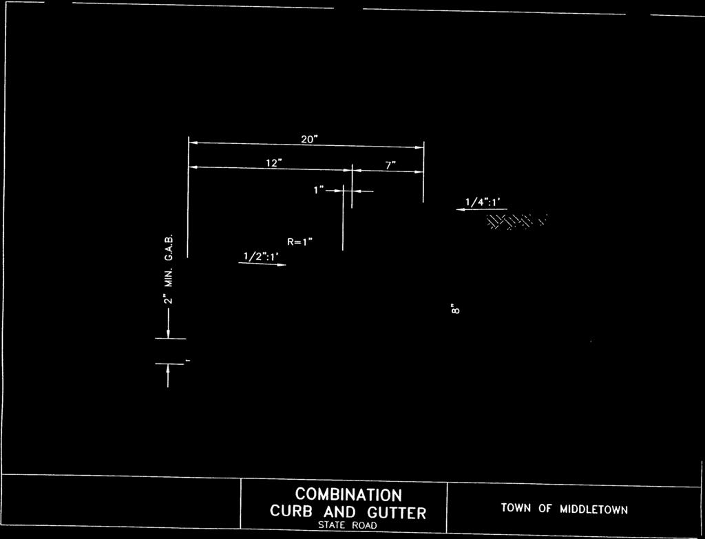
3 3.2 Contract Specifications S Estimate of Quantities and Prices S Design Calculations S-29 APPENDICES Table 1 - Summary of Design Criteria Table 2 - Minimum Separation Guidelines Table 3 - Levels of Service Characteristics Figure 1 - Standard Landing Requirements Standard Details for Construction: Combination Curb and Gutter Typical Sidewalk Installation Typical Driveway - Curb Detail Local Street Typical Cul-de-Sac Collector Structure Minor Arterial Alternate Minor Arterial with Median Major Arterial Alternate Major Arterial Alley Service Road As-Built Drawing Statement TOWN OF MIDDLETOWN, MD S-ii (05/99)
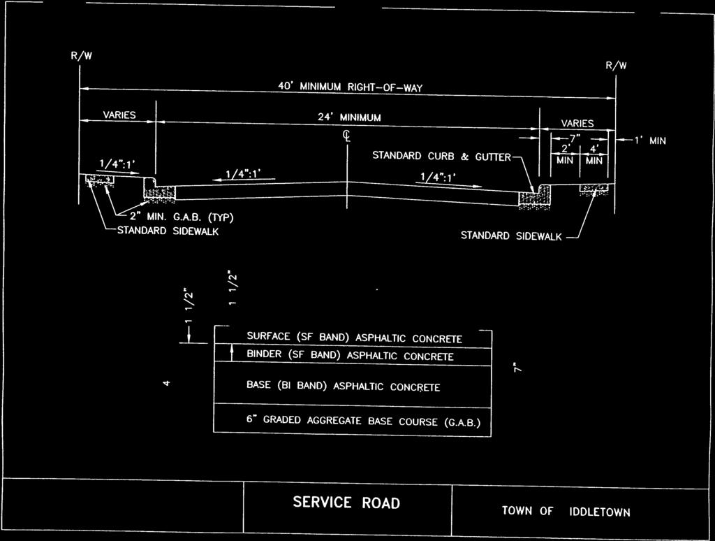
4 STREETS AND ROADS DESIGN MANUAL 1.0 GENERAL 1.1 Definitions a. In these Standards, the terms "roads and streets" identifies any public highway, thoroughfare, road, street, cul-de-sac, or service road. The term "highways" identifies traffic ways under the jurisdiction of the Maryland State Highway Administration. b. Service Road: A local access road to provide a means of egress and ingress to a non-residential development for the purpose of limiting access directly onto a collector or arterial roadway. The minimum right-ofway and pavement width shall be 40 feet and 24 feet, respectively. c. Local Road or Street: The local street comprises all facilities not in use of the higher order systems. It is intended to carry the least amount of traffic at the lowest speed and provide the safest and most desirable environment for a residential neighborhood, with the maximum number of homes fronting the street. The local street provides access to land adjacent to the collector network and serves travel over relatively short distances. The minimum right-of-way and pavement width shall be 50 feet and 32 feet, respectively. d. Collector Road or Street: This is the highest order of street that could be classified as residential. This class of street is necessary to carry traffic from one neighborhood to another or from the neighborhood to streets connecting to other areas in the community. Direct access to homes is discouraged onto collector roads. The minimum right-of-way and pavement width shall be 60 feet and 34 feet, respectively. e. Minor Arterial: This classification of roadway generally provides for movement of vehicles larger in number than collectors and local roads, with no direct access from homes allowed. This classification of roadway receives volumes of traffic from collectors and provides inter- and intra-county access throughout the municipality and county. The minimum right-of-way and pavement width shall be 80 feet and 40 feet, respectively. f. Major Arterial: This is the highest order of street or road. This classification of roadway carries the highest volume of traffic through the municipalities and county and does not provide for direct access from homes or commercial TOWN OF MIDDLETOWN, MD S-1 (05/99)
5 development. The minimum right-of-way and pavement width shall be 100 feet and 48 feet, respectively. g. (ADT) Average Daily Traffic: The total volume of traffic during a given time period (in whole days), greater than one day and less than one year, divided by the number of days in that time period. h. Peak-Hour Traffic: The volume of traffic during the hour of day with the highest volume. For design purposes, this should represent the 30th highest hourly volume of the year, or 30 HV, and generally represents 15% - 25% of the ADT. i. Design Speed: The maximum safe speed that can be maintained over a specified section of road or street when conditions are so favorable that the design features of the road govern. j. Capacity: The maximum hourly rate of traffic at which persons or vehicles can reasonably be expected to traverse a point or uniform section of road during a given time period under prevailing roadway and traffic conditions. k. Stopping Sight Distance: The length of roadway ahead visible to the driver. Stopping sight distance is the sum of two distances: the distance traversed by the vehicle from the instant the driver sights an object necessitating a stop to the instant the brakes are applied; and the distance required to stop the vehicle from the instant the brake application begins. These are referred to as brake reaction distance and braking distance, respectively. l. Passing Sight Distance: The length needed to safely complete normal passing maneuvers, generally determined for a single vehicle passing a single vehicle. The minimum passing sight distance for two-lane roads is determined as the sum of the four distances: 1. Distance traversed during perception and reaction time during the initial acceleration to the point of encroachment on the left lane. 2. Distance traveled while the passing vehicle occupies the left lane. 3. Distance between the passing vehicle at the end of its maneuver and the opposing vehicle. 4. Distance traversed by an opposing vehicle for two-thirds of the time the passing vehicle occupies the left lane, or 2/3 of "2" above. m. AASHTO: American Association of State Highway and Transportation Officials. TOWN OF MIDDLETOWN, MD S-2 (05/99)
6 n. Alley: A public right-of-way which affords only a secondary means of access to abutting properties. 1.2 Responsibility for Design and Construction a. Middletown roads and streets in or related to new development are designed by Developers or their consulting engineers. Town projects are designed by either the Town or consulting engineers. All utilities, roadway curbing and base course paving must be complete prior to issuance of any building permit. Any intersection or signalization improvements required, as part of the subdivision improvements shall be completed prior to any building permit being issued. b. Construction of roads and streets in or related to new development is the responsibility of the Developer. These projects are constructed by either a contractor hired by the Developer or the Developer's own forces. c. The Developer shall provide the Town with a minimum one-year warranty from the date of acceptance of the improvements by the Town for all work constructed by the Developer. The Town shall withhold all of the contingency portion of the surety associated with road work (i.e. paving, curb and gutter, sidewalk) until the warranty period expires. d. The Town will not accept the road improvements until all construction is complete, final paving is installed, build-out is complete, and there is no longer a need to use the completed road for construction traffic. No construction traffic will be permitted on streets that have been accepted by the Town. If phased, only that phase must be complete. A temporary turnaround may be requested at end of each phase but not accepted by the Town. The following Street Acceptance Requirements have been adopted by the Town of Middletown. Any street, cul-de-sac, alley or public right-of-way must meet the requirements of the Middletown Subdivision regulations, Design Manual and other applicable standards and specifications to be taken into the Municipal Street System. The Town of Middletown is not obligated to upgrade any street, cul-de-sac, alley or public right-of-way to these standards unless it is deemed advisable to facilitate traffic flow or to address a public safety matter. The Town of Middletown will not issue a Water and Sewer Tap Permit for any residence or commercial structure having access to and from a new street or street extension for which construction or improvement is the responsibility of the developer/builder until an Interrim Street Agreement has been signed by the developer/builder and the Town of Middletown. This agreement stipulates the following conditions: TOWN OF MIDDLETOWN, MD S-3 (05/99)
7 1.3 Authorization Permits (1) The street will be posted with a sign Not A Town Street - Maintained by developer until completion of construction and acceptance into Municipal Street System. (2) The developer assumes responsibility for maintenance and repair and is liable for any and all personal and property damages resulting from any accident or mishap which occurs as a result of the use of the street, including any damage to municipal snow plows clearing such streets where occupancy permits have been issued. (3) Any such interim agreement between the developer and the Town of Middletown shall contain the condition that the final bituminous concrete surface course be completed on any street where occupany permit(s) have been issued, pass any occupied structure (even if there are undeveloped lots between that structure and the street entrance) within a period of 4 months from the date of the occupancy. At the termination of the 4 month period, the Town may: (a) extend the paving date requirement if it is determined that extenuating circumstances exist; or, (b) enter into a contract with a paving firm to complete the bituminous concrete surface course, the cost of which shall be paid from the developer s Irrevocable Letter of Credit, required to guarantee completion of public works improvements. (4) When the bituminous concrete surface course is in place and approved by DPW and the Town of Middletown, that portion of the street will be accepted for inclusion in the Municipal Street System, relieving the developer of the responsibilities of the Interim Agreement entered into by the developer and the Town for that portion of the street accepted by the Town. a. Where intersections occur with roadways under the jurisdiction of the Maryland State Highway Administration, Frederick county, or other political districts, a permit from the office involved authorizing the proposed construction must be filed with the Town before plans will be approved. b. Where permits are required from other agencies, such as the Natural Resources Conservation Service, Maryland Department of the Environment or Army Corps of Engineers, a signed permit from those agencies having authorization over the project must be filed with the Town before plans will be approved. TOWN OF MIDDLETOWN, MD S-4 (05/99)
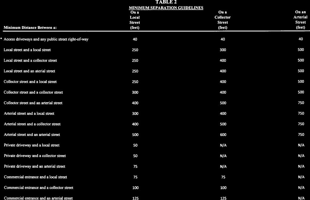
8 1.4 Planning Guidelines The designation or classification of the road, street or alley shall be designed as stipulated in the Town's Comprehensive Plan or as dictated by the Town. The design standards of roads and streets as shown herein shall be used. In the event a development is submitted for review to the Planning Commission as a Planned Unit Development (PUD), the Director of Public Works, at his discretion, may alter the design standards as he deem appropriate. 1.5 Existing Streets Each street abutting or affecting the design of a subdivision or land development which is not already classified in the comprehensive plan shall be classified to its function, design and use by the Town at the request of the applicant or during plan review. The classification of existing streets shall include the hierarchy noted above or classification of higher order, as determined by the Town. 2.0 DESIGN 2.1 Preliminary Considerations The design of roads and streets includes general layout, curb and gutters, signage, sidewalk, alignment, grades, grading, paving widths, paving material, and drainage facilities. Sufficient rights-of-way should be set aside in the early stages of layout to provide for future increases in pavement widths and roadside improvements when practical. When determining alignments and grades of roads and streets, the designer must consider the requirements for utilities, including adequate storm drainage, and he must take into account any unusual aspects of the design, such as railroad crossings, floodplain crossings, intersection improvements with State or County roads and traffic signals. 2.2 Layout of Intersections a. Centerlines of traffic ways shall continue through intersections without offsets and shall intersect as nearly as possible at right angles. Where various conditions make a right angle intersection impracticable, the minimum deflection angle between the centerline of a street and the centerline of any other street shall be 60 degrees or 70 degrees when intersecting State Roads. b. There must be an unobstructed sight distance along all approaches at an intersection across their included corners for a distance sufficient to allow TOWN OF MIDDLETOWN, MD S-5 (05/99)
9 operators of vehicles to accelerate, slow down, or stop. The design is commonly called the intersection sight triangle. All intersections should be designed with angle of intersection at 90 degrees. AASHTO's discussion of intersection sight distance shall predominate, but is too long to be included here. Since local residential access streets will inherently be low speed roads, then one can plan on only having to satisfy AASHTO's requirement for 30 mph situations. Stopped intersections of local roads shall have a minimum sight distance of 150 feet. AASHTO's guidelines, as discussed in A Policy on Geometric Design of Highways and Street, latest edition, Chapters 5, 6, and 7, will govern except as modified in this design manual. c. At the intersection of two (2) closed section streets, consideration must be given to the radius of the return. A minimum curb radius of 20 feet should be provided with 25 feet minimum at the intersection with State or County highways. d. At an intersection of an alley and a street, the standard radius of the return shall be 10 feet to face of curb. Where the distance on the street between the face of the curb and property line is less than 10 feet, that distance shall become the return radius. e. Where alleys intersect at 90 degree angles, the fillet triangle formed shall have legs of 15 feet. At intersections other than 90 degrees, the fillet triangles shall be subject to approval by the Town. f. The cut-back of property lines at intersections shall be governed by the following criteria: 1. At an intersection of roadways (other than alleys), the cut-back of the property line normally shall be a chord connecting the points on the property lines directly opposite the Point of Curvature (P.C.) and Point of Tangency (P.T.) of the curb return or edge of pavement return. In any case, the minimum distance from the property line Point of Intersection (P.I.) at an intersection and the property line chord points shall be a minimum of 10 feet. 2. At an intersection of an alley and a street, the property line shall not be cut-back. 3. At an intersection of alleys, the property line shall conform with the pavement fillet. TOWN OF MIDDLETOWN, MD S-6 (05/99)
10 g. A clear zone should be established that is free of all opaque obstructions greater than 3.0 feet high above the curb elevation. Such objects typically include: buildings, cut slopes, hedges, trees, bushes, or tall crops. The triangular dimensions of the zone allow for the desired sight lines. This triangle shall have a minimum of 35 feet dimension on the edge of the pavement on both legs. This distance may be increased by the Town if deemed appropriate for safety reasons. This design requires elimination of parking within the sight triangle. Street signs, fire hydrants, and utility poles typically can be located within a sight triangle, as long as they are not clustered and do not contribute to sight limitation. h. Intersections shall be no less than 250 feet apart between roadway centerlines. (Local streets only.) i. Refer to Table 2 in the Appendix for separation guidelines. j. In certain situations, the design and construction of turning lanes or acceleration/deceleration lanes at intersections may be required to facilitate the movement of traffic through an intersection and improve traffic capacity and level of service. The Director of Public Works reserves the right to require additional lanes of roadway for this purpose and to require additional rights-of-way to accommodate the additional lanes. Intersections will be reviewed on a case-bycase basis, and a final determination made by the Director of Public Works as to the necessity for and the geometric requirements for additional turning lanes. k. Intersections of more than two (2) streets at an intersection shall be prohibited. 2.3 Horizontal Curves a. Where road and street centerlines change direction by more than one degree (1 ), they shall be connected by a horizontal curve with a radius to insure a minimum horizontal sight distance, as shown in Table 1. Minimum radii of horizontal curves shall be limited as directed by the Table's minimum radius. The minimum radius of a horizontal curve shall be 150 feet. b. Property lines which change direction through angles less than one degree (1 ) need not have a horizontal curve introduced at the break, unless otherwise directed by the Town. c. Horizontal curve data shall be computed by the arc definition of a circular curve. A tangent of at least 100 feet shall be used between reverse curves. Horizontal alignments using compound curves shall be avoided. TOWN OF MIDDLETOWN, MD S-7 (05/99)
11 2.4 Superelevation Horizontal curves of road and streets in subdivisions, commercial and industrial areas, regardless of classification, shall not be superelevated. 2.5 Cul-de-Sacs; Tee Turn-Arounds; Driveways Cul-de-Sacs a. Generally, all residential parcels should be accessible from two directions. This usually reduces total vehicle miles of travel and improves emergency vehicle access. However, the most efficient subdivision of certain tracts (considering shape and terrain) may work best by locating limited numbers of lots along dead-end streets. b. An 800-foot length shall be the maximum for cul-de-sacs unless otherwise approved by the Director of Public Works. The minimum right-of-way radius for a traditional circular cul-de-sac is 50 feet. No eyebrow cul-desacs shall be permitted. The minimum length of a cul-de-sac shall be 350 feet from the centerline of the intersecting street to cul-de-sac curb. The minimum outside pavement/curb radius is 40 feet. Larger cul-de-sacs will be required in subdivisions with very large lots with sufficient lot width to allow curb parking around the cul-de-sac. The curb parking creates the need for larger pavement/curb radii to accommodate the parking, while providing sufficient turning radius for large trucks and fire apparatus. Oversized cul-de-sacs will also be required for school bus access, as determined necessary by staff at the preliminary plan stage. The minimum diameter of the right-of-way for over-sized cul-de-sacs, when required by the Town, shall be 150 feet. c. When outside curb (pavement) radii of 40 feet or greater are used, they create large expanses of pavement which may be unsightly. The use of center islands may be considered to reduce this paved area, if care is given to keeping adequate maneuver space around the island. A minimum pavement driving width of 20 feet is required around the island. The use and design of islands will be at the discretion of the Director of Public Works. All islands, when approved by the Town, will be rolled curbed. d. In addition to the traditional circular cul-de-sac, an offset cul-de-sac may be provided. Generally, offset cul-de-sacs are used to overcome environment, topographic and property constraints. TOWN OF MIDDLETOWN, MD S-8 (05/99)
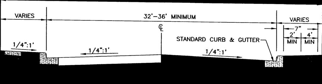
12 e. At the connector between the cul-de-sac right-of-way, a transition radius is required. This radius should be at least 50 feet, to avoid an unsightly sidewalk layout and to provide smooth turning movements into and out of the cul-de-sac. Also, a more constant curb to right-of-way line dimension is achieved Tee Turn-Arounds Tee Turn-Arounds will not be permitted as temporary or permanent facilities Driveways 2.6 Design Speed Layout of driveway entrances shall conform with the applicable Typical Driveway Entrance Detail, shown in the Appendix. Designation of a design speed is suspended here because other design elements serve to "limit" speeds in residential areas. Wherever possible in the other sections, an effort to design for 30 mph or less has been considered. Lower design speeds must be considered as progressively more difficult terrain is encountered. The Developer or his Engineer shall submit with each project a proposed mechanism or method(s) for reducing traffic speed on the roadways being designed, particularly in residential areas. The mechanism or method(s) to achieve the desired result of reducing traffic speeds may consist of one or more different approaches. 2.7 Minimum Centerline Radius of Curves The minimum centerline values for design of streets and roads are provided in Table 1. These values relate to mid-block horizontal centerline curves and not to intersection radii. When a street makes a right angle or 90 degree turn, a much shorter centerline radius, such as 50-feet centerline, will apply. 2.8 Minimum Tangent Between Reverse Curves A minimum tangent of 100 feet at curves and intersections is needed between reverse curves to facilitate steering and control. Refer to Table 1 for minimum lengths for various roadway classifications. 2.9 On-Street Parking TOWN OF MIDDLETOWN, MD S-9 (05/99)
13 a. Off-street parking requirements are addressed in the zoning and subdivision regulations. However, the adequacy of street widths is tied to available off-street parking and the need to provide on-street parking capability when off-street parking is not sufficient. The pavement widths provided in Table 1, and as shown in the Standard Details in the Appendix of this manual, provide the opportunity for on-street parking. b. Studies have shown curb parking to be a primary factor in accidents on all types of streets. The number of children killed and injured each year as a result of entering the street from behind parked cars is particularly tragic. For these reasons, every development must meet off-street parking requirements so as to minimize curb parking. c. Angle parking along the curbs of local streets should never be allowed. When traffic lanes are used for parking and parking maneuvers, the accident potential is much higher than with parallel parking. Therefore, all such bays and lots allowing any parking other than parallel, should be physically separated from the roadway and confined by barrier curbing beyond the street and the sidewalks Driveway Aprons a. Because they are deceptively simple in appearance, driveway aprons often do not receive the design consideration that they merit. Common deficiencies include: 1. Inadequate radii at intersection with street; 2. Excessive grades and grade changes (breakover angles); 3. Inadequate width and depth of paving; 4. Inadequate sight-distance due to landscaping; 5. Poor drainage characteristics. b. The typical residential driveway apron should be designed for passenger car operation only. The driveway radius or flare should be designed with consideration given to both the driveway and road width. The driveway slope shall not exceed 10 percent at any point from the right of way line to the finished garage floor. Refer to the Standard Details in the Appendix of this manual for a typical driveway apron design. TOWN OF MIDDLETOWN, MD S-10 (05/99)
14 2.11 Minimum Tangent Length Approaching Intersection It is desirable to provide a tangent section of roadway approaching intersections, when the street leg has minimum or near-minimum radius curve. However, curving collector streets need not have tangents approaching intersections with local streets, if the collector radius is 1,000 feet or greater Drainage Structures a. Inlets or catch basins should not be located within the corner radius or within 6 feet of either end. Clearance is needed to keep the area relatively dry and to allow space for street lights, name signs, utility poles, etc. Grate design should provide for safety of bicycle traffic. b. Special considerations should be given to the middle of the curb return at the upper end of the intersection of two streets in a downhill condition. A small area of ponding in the gutter can be created due to the gutter slope. Detailed spot elevations must be provided to show that all drainage will flow to the appropriate storm drain inlet Traffic Control All signs, including stop signs and street identification signs, will be placed by the Developer at the expense of the Developer, according to the Manual of Uniform Traffic Control Design (MUTCD). All intersections of Town roads and streets with other private or public streets, with the exception of State and County roads, are under the jurisdiction of the Town of Middletown. Intersections at State facilities are under Maryland State Highway Administration jurisdiction. On Town roads and streets, the curbs shall be painted 7.5 feet on each side of a hydrant and along the curbed radius to a point 20 feet beyond the end of the radius in each direction. Centerline road markings may be required on all roads and streets except local roads as determined by the Burgess and Commissioners. Stop lines will be required on all roads and streets at stop signs. Crosswalks will be required as dictated by the Director of Public Works Commercial Driveway Entrances a. The minimum width of a commercial driveway access shall be 30 feet. b. Median-divided entrance roads are permitted; however, they must meet a minimum 100-foot depth. The median width may range from 4 feet to 10 feet. The minimum drive-aisle width shall be 14 feet. Any other non-standard design (channelization, right-in, right-out, angled entrances, etc.) must be approved by the Town on a case-by-case basis. TOWN OF MIDDLETOWN, MD S-11 (05/99)
15 2.15 Grades c. In all cases, the minimum curb return of radius shall be 25 feet and shall have curbed edge protection. Larger radii are recommended for larger design vehicles. d. For all commercial driveways having access to higher volume, higher classified roads, the Town can require that acceleration/deceleration lanes and bypass lanes with additional right-of-way be provided. When required by the Town, a sufficient bypass lane design shall include, as a minimum onto a collector road, a 150 feet departure taper, a 150 feet bypass, a 100 feet transition, and a 150 feet merge taper. When access is onto a minor or major arterial, a 300 feet departure taper, a 300 feet bypass, a 200 feet transition, and a 300 feet merge taper shall apply. The bypass lane shall be a full width lane equal to or greater than the travel lane width Roadways a. The minimum allowable grade of roadways shall be 0.50%. b. The maximum grades of roadways shall be as shown in Table 1. c. To meet the criteria for cul-de-sacs, the grades across the circular portions of cul-de-sacs shall be flattened when necessary: the grade along the centerline extended across the circular portion of any cul-de-sac shall not exceed a mean of 6%. d. At an intersection of two roadways, the normal typical section of the priority traffic way shall continue through the intersection without break. The crown of the other traffic way shall be warped from its normal section to connect to the edge of the priority traffic way. Where two traffic ways of equal importance intersect, one shall be considered as a priority traffic way in order to accomplish the foregoing connection, except where the design engineer is unable to determine satisfactorily either one of the intersecting traffic ways as a priority traffic way. In this case, the Town shall be consulted Intersections with State Roads Approach grades to Maryland State Highway Administration shall be governed by the State Highway Administration. TOWN OF MIDDLETOWN, MD S-12 (05/99)
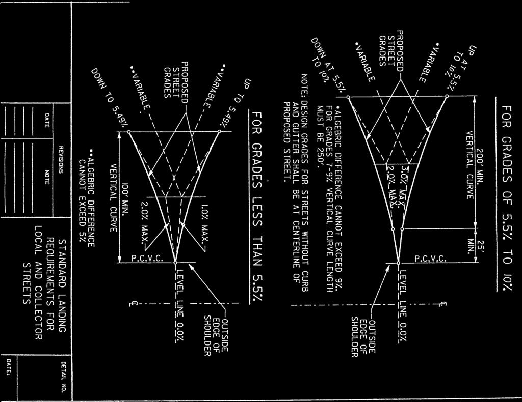
16 2.16 Vertical Curves a. To avoid an abrupt change in vertical alignment when passing from one grade to another, a vertical curve shall be used at the grade intersection whenever the algebraic difference in the percents of a grade is 0.25 or greater. b. Elevations on vertical curves shall be computed by the parabolic curve formula, except for rehabilitated streets when it becomes impractical, due to the use of other curves. The elevations of other curves may be scaled when the profile is plotted on a scale of 1 inch = 50 feet horizontal and 1 inch = 5 feet vertical. c. The minimum length of a vertical curve may include a compound curve, but not a reverse curve, and shall not be less than 100 feet. d. The parabolic curve is used almost exclusively in connecting grade tangents because of the convenient manner in which the vertical offsets can be computed. Figure 1 in the Appendix provides the Standard Landing Requirements for Local and Collector Streets. A typical symmetrical vertical curve is shown below. PARABOLIC VERTICAL CURVE P.V.C..... Point of Vertical Curvature P.V.I..... Point of Vertical Intersection P.V.T..... Point of Vertical Tangency E..... External Distance - in feet L..... Length of Curve - in feet g1.... Grade from which stationing starts (in %) l.... 1/2 or half the Length of Curve y.... Offset in feet x.... Any Distance from P.V.C. in feet g2.... Grade toward which station heads (in %) To design the curve for use in profile drawings, first the minimum allowable length of curve must be established. This minimum length is: K (a constant) multiplied by the absolute value of the algebraic difference of the two grades (in percent). Per AASHTO for a design speed of 30 mph in a crest (1) condition K = 30 and a sag (2) condition K = 40. For other design speeds, refer to Table 1. (1) A vertical crest is the same as a hill or high point, with the extensions of the two tangents forming an angle point up. TOWN OF MIDDLETOWN, MD S-13 (05/99)
17 (2) A vertical sag is the same as a valley or low point, with the extensions of the two tangents forming an angle pointing down. Other equations that may be helpful are as follows: Lmin = K x (gl - g2) = Minimum Vertical Curve Lengths (g1 - g2) L E = 800 = Vertical Offset at P.V.I. g1 - g2 r = L(in stations) = Rate of Grade Change r y = 2 x 2 + glx + Elevation P.V.C. = Vertical Offset of any point X Station from the P.V.C. In order to determine the high (low) point along the curve, use the equation -gl X (in stations) = r e. An effort shall be made to avoid the placing of horizontal curves along crest vertical curves. Where such design is unavoidable, the sight distance of the vertical curve shall not be less than the horizontal curve sight distance, and the limits of the horizontal curve shall extend beyond the limits of the vertical curve Underdrains To drain free water from subgrades in excavated areas, underdrains shall be incorporated into the design of new roadways wherever there is a possibility of water undermining the traffic way subgrade. See Standard Details and of the State Highway Administration for Construction Methods Guard Rail a. Guard rail shall be erected on roadways at points of extreme hazard to a vehicle leaving the traveled portion of the traffic way. Generally, this potential hazard develops at fills over 8 feet in vertical depth from the edge of the curb or right-ofway to the toe of the slope. Guard rail shall be placed behind the curb and sidewalk. b. Where roadway construction ends in fill areas, temporary barricade posts shall be erected. c. For guard rail details, refer to the State Highway Administration Construction Details series 660. TOWN OF MIDDLETOWN, MD S-14 (05/99)
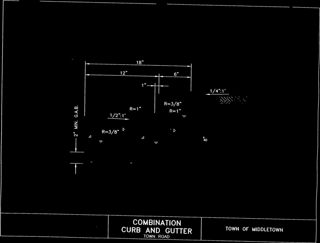
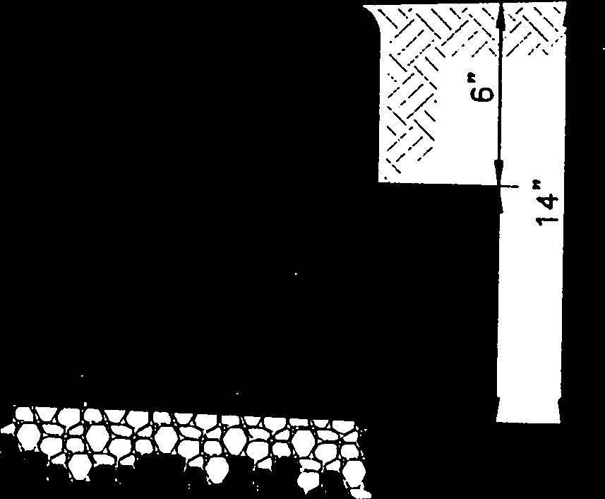
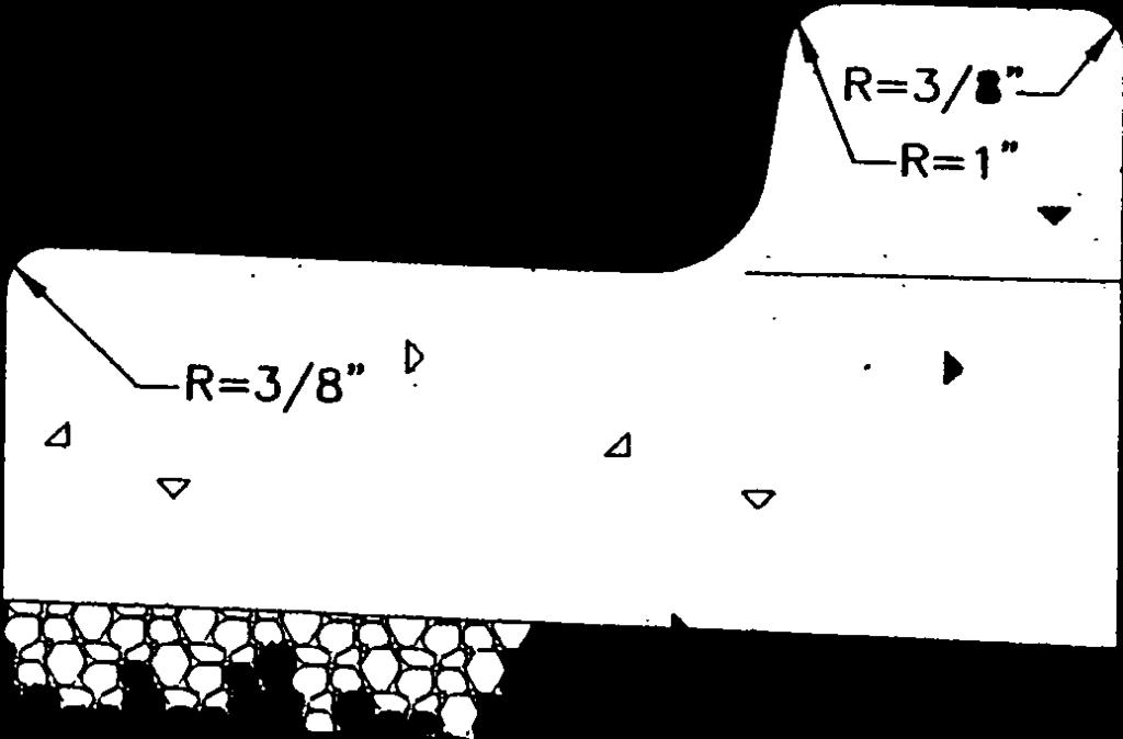
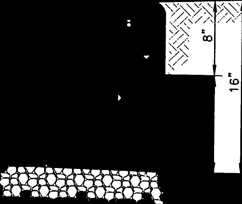
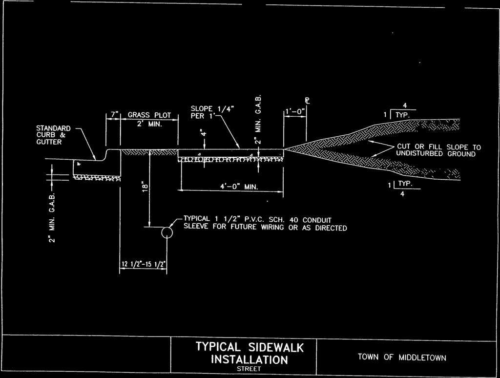
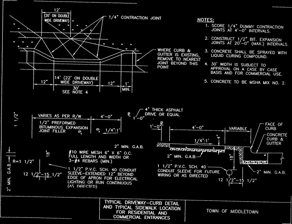
18 2.19 Sidewalks and Curb and Gutters Concrete sidewalks and curb and gutters shall be required on both sides of all new roadways, regardless of classification. Refer to the Standard Details in the Appendix of this manual for Construction Details and Location Cross Sections and Quantities a. Cross sections for roadways shall be taken at least every 50 feet and at all noticeable terrain breaks. The centerline and profile grade line shall be stationed correspondingly. b. The design engineer shall provide quantity estimates to the Town. These estimates shall include all quantities for grading, paving, curb and gutter, excavation, embankment, etc., and shall be tabulated as directed by the Town Traffic Impact Studies Purpose a. Whenever a proposed project will generate one hundred (100) new vehicle trips in the peak direction (inbound or outbound) during the site peak traffic hour, the applicant shall perform a traffic impact study. Based on this study, certain improvements may be identified to provide safe and efficient access to the development. Studies shall be done on normal weekdays, excluding holidays and when schools are in session. b. In addition, a traffic impact study shall be prepared whenever either one of the following conditions exist within the impact study area: 1. Current traffic problems exist in the local area, such as a highaccident location, confusing intersection, or a congested intersection which directly affects access to the development. 2. The ability of the existing roadway system to handle increased traffic or the feasibility of improving the roadway system to handle increased traffic is limited, as determined by the Town. 3. Study is required as a condition of all annexation and rezoning applications. TOWN OF MIDDLETOWN, MD S-15 (05/99)
19 Traffic Impact Study Area of Traffic Impact Study The traffic impact study area shall be based on the characteristics of the surrounding area. The intersections to be included in the study shall be adjacent to the site or have direct impact upon the access to the site. Intersection and study areas shall be determined by the Town during a scoping session, to be attended by the Town staff, State and County representatives, and the Developer's Engineer responsible for preparing the Study. The Town shall be called upon to resolve any disputes between the municipality and the traffic engineer Preparation by Transportation Engineer Required Traffic impact studies shall be prepared under the supervision of qualified and experienced transportation engineers with specific training in traffic and transportation engineering and at least 2 years of experience related to preparing traffic studies for existing or proposed developments Horizon Year The traffic forecasts shall be prepared for the anticipated opening year of the development, assuming full buildout and occupancy. This year shall be referred to as the horizon year in the remainder of this section Non-Site Traffic Estimates Estimates of non-site traffic shall be made and will consist of through traffic and traffic generated by all other developments within the study area for which preliminary or final plans have been approved. Non-site traffic may be estimated using any one of the following three methods: "Build-up" technique; area transportation plan data or modeled volumes; and trends or growth rates Warrants The traffic impact study shall include a warrant analysis at each intersection (as determined in ) in accordance with the warrants requirements in the Manual on Uniform Traffic Control Devices, latest edition. The traffic impact study shall include an accident history record at TOWN OF MIDDLETOWN, MD S-16 (05/99)
20 each intersection and the 85th percentile speed of all vehicles on the approaches to each intersection Trip Generated Rates Required The traffic impact study report shall include a table showing the categories and quantities of land uses, with the corresponding trip generation rates or equations (with justification for selection of one or the other), and resulting number of trips. The trip generation rates used must be either from the latest edition of Trip Generation by ITE or from a local study of corresponding land uses and quantities. All sources must be referenced in the study Consideration of Pass-By Trips If pass-by trips or shared trips are a major consideration for the land use in question, studies and interviews at similar land uses must be conducted or referenced Rate Sums Any significant difference between the sums of single-use rates and proposed mixed-use estimates must be justified in the study report Explanations Required The reasoning and data used in developing a trip generation rate for special/unusually generators must be justified and explained in the report Definition of Influence Area a. Prior to trip distribution of site-generated trips, an influence area must be defined which contains eighty percent (80%) or more of the trip ends that will be attracted to the development. A market study can be used to establish the limits of an influence area, if available. If no market study is available, an influence area should be estimated based on a reasonable documented estimate. The influence area can also be based on a reasonable maximum convenient travel time to the site or delineating area boundaries based on locations of competing developments. TOWN OF MIDDLETOWN, MD S-17 (05/99)
21 b. Other methods, such as using trip data from an existing development with similar characteristics or using an existing origin-destination survey of trips within the area, can be used in place of the influence area to delineate the boundaries of the impact Estimates of Trip Distribution Required a. Trip distribution can be estimated using any one of the following three methods: 1. analogy 2. trip distribution model 3. surrogate data b. Whichever method is used, trip distribution must be estimated and analyzed for the horizon year. A multi-use development may require more than one distribution and coinciding assignment for each phase (for example, residential and retail phases on the same site). Consideration must also be given to whether inbound and outbound trips will have similar distributions Trip Assignments a. Assignments must be made considering logical routings, available roadway capacities, left turns at critical intersections, and projected (and perceived) minimum travel times. In addition, multiple paths should often be assigned between origins and destinations to achieve realistic estimates, rather than assigning all of the trips to the route with the shortest travel time. The assignments must be carried through the external site access points and in large projects (those producing five hundred (500) or more additional peak direction trips to or from the site during the development's peak hour) through the internal roadways. When the site has more than one access driveway, logical routing and possibly multiple paths should be used to obtain realistic driveway volumes. The assignment should reflect conditions at the time of the analysis. Assignments can be accomplished either manually or with applicable computer models. TOWN OF MIDDLETOWN, MD S-18 (05/99)
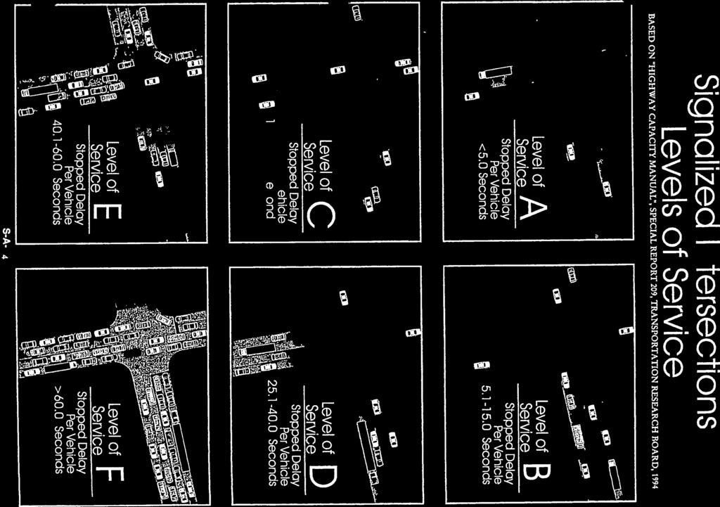
22 b. If a thorough analysis is required to account for pass-by trips, the following procedure should be used: 1. Determine the percentage of pass-by trips in the total trips generated. 2. Estimate a trip distribution for the pass-by trips. 3. Perform two separate trip assignments, based on the new and pass-by trip distributions. 4. Combine the pass-by and new trip assignment. c. Upon completion of the initial site traffic assignment, the results should be reviewed to see if the volumes appear logical, given characteristics of the road system and trip distribution. Adjustments should be made if the initial results do not appear to be logical or reasonable Total Traffic Impacts Traffic estimates for any site with current traffic activity must reflect not only new traffic associated with the site's redevelopment but also the trips subtracted from the traffic stream because of removal of a land use. The traffic impact report should clearly depict the total traffic estimate and its components Capacity Analysis a. Capacity analysis must be performed at each of the major street and project site access intersection locations (signalized and unsignalized) within the study area. In addition, analyses must be completed for roadway segments deemed sensitive to site traffic within the study area. These may include such segments as weaving sections, ramps, internal site roadways, parking facility access points, and reservoirs for vehicles queuing off-site and onsite. Other locations may be deemed appropriate depending on the situation. b. The recommended level-of-service analysis procedures detailed in the most recent edition of the Highway Capacity Manual must be followed. The Town of Middletown considers the overall level-ofservice ratings A, B, and C to be acceptable for signalized TOWN OF MIDDLETOWN, MD S-19 (05/99)
23 intersections; level-of-service D, E or F is considered to be unacceptable. Refer to the Appendix for Level of Service Criteria. c. The operational analyses in the Highway Capacity Manual should be used for analyzing existing conditions, traffic impacts, access requirements, or other future conditions for which traffic, geometric, and control parameters can be established Required Levels-of-Service The recommendations of the traffic impact study shall provide safe and efficient movement of traffic to and from and within and past the proposed development, while minimizing the impact to non-site trips. The current levels of service must be maintained if they are C, not allowed to deteriorate to worse than C if they are currently A or B, and improved to C if they are D, E or F Documentation Required a. A traffic impact study report shall be prepared to document the purpose, procedures, findings, conclusions, and recommendations of the study. 1. The documentation for a traffic impact study shall include, at a minimum: a.) Study purpose and objectives. b.) Description of the site and study area. c.) Existing conditions in the area of the development. d.) Recorded or approved nearby development. e.) Trip generation, trip distribution, and modal split. f.) Project future traffic volumes. g.) An assessment of the change in roadway operating conditions resulting from the development traffic. h.) Recommendations for site access and transportation improvements needed to maintain traffic flow to, from, within, and past the site at an TOWN OF MIDDLETOWN, MD S-20 (05/99)
24 Improvements acceptable and safe level-of-service. b. The analysis shall be presented in a straight forward and logical sequence. It shall lead the reader step-by-step through the various stages of the process and resulting conclusions and recommendations. c. The recommendations shall specify the time period within which the improvements should be made (particularly if the improvements are associated with various phases of the development construction), and any monitoring of operating conditions and improvements that may be required. d. Data shall be presented in tables, graphs, maps, and diagrams wherever possible for clarity and ease of review. e. To facilitate examination by the Town, an executive summary of one or two pages shall be provided, concisely summarizing the purpose, conclusions, and recommendations. f. The report documentation outlined above provides a framework for site traffic access/impact study reports. Some studies will be easily documented using this outline. However, the specific issues to be addressed, local study requirements, and the study results may warrant additional sections Responsibility for Improvements The applicant shall be responsible for the improvements required to provide safe and convenient ingress and egress to the development site Coordination with Municipal Requirements The applicant shall be responsible for other improvements as may be agreed to with Middletown or which are required by any municipal adequate public facilities, impact fee or improvement fee, or other ordinance and which improvements shall be installed or paid for by the applicant. TOWN OF MIDDLETOWN, MD S-21 (05/99)
25 3.0 CONTRACT DRAWINGS AND DOCUMENTS TO BE SUBMITTED TO TOWN 3.1 Contract Drawings General a. Roadway layouts shall be prepared on sheets separate from other utilities. These drawings shall be made on standard size tracing mylar film, with titling as required by the Town, and shall be rendered in black ink. b. On all Road and Street projects, including improvements to existing roads and where a subdivision abuts on only one side of the road, cross sections shall be taken in the field. Maximum distance between cross sections shall be 50 feet, with intermediate cross sections taken as needed to show a true picture of the topography. The cross sections shall extend to a point sufficient to determine the slope and other easements. c. The cross sections shall be plotted on standard cross section paper 10 x 10 graduations to the inch. The scale for plotting the cross sections shall be 1 inch = 10 feet both vertical and horizontal. The original ground line and the proposed road section shall be shown. d. The plan shall be drawn to a scale of 1 inch = 50 feet or larger. The profile shall be drawn to a horizontal scale of 1 inch = 50 feet or larger and a vertical scale of 1 inch = 5 feet. e. Drawing numbers of other utilities (water, storm drainage, etc.) being prepared for the development at the same time shall be shown on the plan portion of the roadway drawings. f. A location map drawn to a scale of 1 inch = 500 feet shall appear on the first drawing of the traffic way drawings. In remote areas, an additional location map on a small scale, such as 1 inch = 2000 feet, shall be required so that existing roadways may be used for orientation reference. g. The applicant shall submit ten (10) copies of all plans for review by the Town. Signature blocks shall be provided for TOWN OF MIDDLETOWN, MD S-22 (05/99)
26 3.1.2 Plan signature by: Natural Resource Conservation Service; Town of Middletown Planning Commission; Town of Middletown Engineer; Frederick County Dept. of Public Works for Sewer and Storm Water Management only. h. Three (3) copies of final plans shall be submitted to the Office of Planning and Zoning for use by the Town in updating the Town's maps. i. One (1) copy of the As-Built drawings on mylar plan sheets with the statement and Engineer's signature, as shown in the Appendix, shall be submitted to the Office of Planning and Zoning within thirty (30) days of completion and acceptance of the work by the Town and on computer or GIS diskette in a format approved by the Office of Planning and Zoning Street Names The names of all roadways shall be clearly lettered either along the street centerline or along one property line, whichever location is more convenient; however, all names on each drawing shall be placed in the same relative position Widths of Right-of-Way, Pavement and Easements Widths of existing and proposed rights-of-way and pavements for each traffic way shall be shown with dimensioning. Slope easement where established and utility easements and rights-ofway which intersect traffic way rights-of-way shall be shown with dimensioning Topography The location of all structures above the subgrade shall be shown, all topography, including poles, trees, fences, hedges, property markers, buildings and other structures. This topography shall be carried at least 100 feet beyond TOWN OF MIDDLETOWN, MD S-23 (05/99)
27 right-of-way lines, 200 feet beyond the ends of roadways or beyond approval limits, and 200 feet in each direction from an intersection. When shown, all measurements for utility structures, poles, trees, fences and hedges shall be dimensioned from the roadway centerline Coordinates, Bearings, and Ties a. Bearings of roadway centerlines and coordinates of centerline P.C.s and P.T.s and of intersecting traffic way centerline P.I.s shall be shown along the respective centerlines. b. In addition to the above requirements, al P.I.s, P.C.s, P.T.s and other points that are needed to re-establish the centerline of the traffic way shall be referenced to permanent features or guarded hub stakes that will not be disturbed prior to the completion of all work. c. The location and description of all reference points and the distance or angles to the centerline control points shall be shown on all Roads and Street drawings Horizontal Curve Information Centerline curve information for each horizontal curve shall be tabulated on the plan in the following manner: _ = D = ' " (Degree of curve) R =. ' (Centerline radius) T =. ' (Tangent Length) L =. ' (Length of curve) ' " (Angle of intersecti _, or Delta, is the external angle of intersection of the tangents at the P.I Stationing a. Stationing along the centerlines of tangents shall be in even 100 feet stations, indicated by a small circle TOWN OF MIDDLETOWN, MD S-24 (05/99)
28 and the station number. Stationing along horizontal curves shall be indicated in like manner. b. P.C.s and P.T.s of horizontal curves shall also be indicated by a small circle on the centerline and their stations shown to the nearest hundredth of a foot. c. Stations of P.C.s and P.T.s of curbs on circular portions of cul-de-sacs shall be shown on the plan. d. P.I.s of intersecting traffic way centerlines shall be indicated by a small double circle at the centerline intersection, and the equality to the nearest hundredth of a foot shall be lettered thereunder Match Lines Traffic way plan portions shall be continued from one sheet to the next with match lines. In addition, the last 200' of each section of a traffic way plan shall be repeated on the next adjacent section P.I.s of Curb Lines The points of intersection of curb lines shall be indicated by small linked crosses and shall be identified thereunder as N.E., N.W., S.W., or S.E Direction of Drainage a. Arrows approximately 1/2 inch long shall be drawn around all curb returns and at all critical drainage points to indicate the direction of surface water flow in ditches or gutters. b. Wherever the slope of a gutter is reversed from the traffic way slope, a note to that effect shall appear on the plan. c. When an inlet adjacent to a curb return is to be set to such an elevation that it serves as the low point along the curb return, and the grades of the intersecting traffic ways are such that a true picture of the top curb grade in the inlet area is not feasible on the profile, TOWN OF MIDDLETOWN, MD S-25 (05/99)
29 Storm Drainage Profiles then a note shall appear on the plan stating that the top curb grades in the inlet area shall be set in the field to locate the sump at the inlet. a. The design engineer shall indicate on the traffic way plans all of the proposed storm drainage system in the right-of-way. The storm drainage shall be shown schematically by a single dashed line, with inlets and drainage structures and direction of flow indicated. b. If the storm drain system is of minor nature with no other utilities involved, the design engineer may include the storm drain plans on the roadway contract. For instructions on storm drainage, see Section on Storm Drains, Design Manual Centerline Grade a. The Centerline Grade submitted for approval shall be shown and designated "CL GRADE." On profiles where the grades are warped, or less than 1 percent slope, spot elevations will be required to clarify the proper grade and direction of slope desired by the Engineer. b. Circles, as shown in the Standard Symbols, shall be used on profile grade lines to designate vertical curve P.V.C.s, P.V.R.C.s, and P.V.T.s and P.I.s of intersecting top curb lines or centerlines. All percents of grades shall be shown to two decimal places Previously Established Top of Curb Grade and Centerline Grade Where a grade line shown on a drawing is taken from a previously established grade, it shall be designated as "ESTABLISHED TOP OF CURB GRADE" or "ESTABLISHED CL GRADE." The date established and the design drawing number of such previously established grades shall be noted on the profile. On existing pavement, TOWN OF MIDDLETOWN, MD S-26 (05/99)
30 grades shall be field surveyed Existing Ground Profiles at Centerlines and Property Lines The profile of the existing ground along the centerline of a proposed roadway and the profile of the existing ground line along property lines shall be shown by dashed ink lines. The existing ground profiles shall be so labeled, and the date and datum of the field survey shall be indicated Vertical Curves A vertical curve shall be shown on profiles as a smooth curve between tangents. The correct templates for given vertical curves will be tangent at the P.V.C. and P.V.T. and will pass through the computed middle ordinate elevation at the P.I. Computation of the middle ordinate will be required, except where difficult to compute at unusual intersection situations Top of Curb Grades for Cul-de-Sacs Top of curb grades for cul-de-sacs shall be shown independently as profiles running linearly around the perimeter of the cul-de-sac including the approach returns. An additional 100 feet overlap on each end of the linear profile shall be shown Stationing and Elevations a. Stations of all points of intersection of curb lines and pavement edges shall be determined at right angles to the centerline. Therefore, a face of curb line shall not be extended to intersect a centerline at a skew in order to establish a station. b. Throughout profiles, elevations shall usually be shown for each 50 feet station with additional elevations every 25 feet throughout horizontal and vertical curves. Stationing shall be in ink at these points on the profile. TOWN OF MIDDLETOWN, MD S-27 (05/99)
31 c. Elevations on tangents shall be computed; elevations on vertical curves shall be computed. Elevations shall be shown to the hundredths of a foot Extension of Profiles Typical Sections a. At any point where a proposed traffic way is an extension of an existing traffic way, the profile of the existing centerline or top curb shall be shown for at least another 200 feet and the heights of the curb face note. All roadway profiles shall be extended a sufficient distance to define clearly the situation, and this distance shall never be less than 200 feet beyond the approval limits requested, except in the case of a profile terminating at a tee intersection. These profiles shall be independent and shown apart from the proposed top curb profile or profiles. b. Where profiles must be broken and continued on the same or other sheets, a minimum of 200 feet of profile shall be repeated. Typical sections of each type of proposed roadway (i.e. paving width and/or right-of-way width) to be constructed shall be shown once on each set of construction drawings. These sections shall conform with the typical sections shown in the Standard Road and Street Details in the Appendix of this manual Pavement Markings, Signage, Traffic Signals, Street Lights Plans and details of all pavement markings, signage, street lights, and traffic signals shall be provided. The Developer shall procure and install all signs at the Developer's expense in conformance with the plans prepared by the Developer and approved by the Town. Pavement markings shall be installed by the Developer in accordance with the approved plans and this Design Manual. 3.2 Contract Specifications Proposed work not covered by Middletown Standard Specifications for Construction shall be covered in the Frederick County Specifications. TOWN OF MIDDLETOWN, MD S-28 (05/99)
32 3.3 Estimate of Quantities and Prices The design engineer shall furnish estimates of all quantities and prices, including a 50% contingency. 3.4 Design Calculations The design engineer shall submit three copies of design calculations made in connection with the project. The calculations shall be submitted along with the contract drawings. TOWN OF MIDDLETOWN, MD S-29 (05/99)

33


34

35

36


37

38

39
40
41
42
43

44
45


46
47

48

49


50


51

52
53

54
CHAPTER 9: VEHICULAR ACCESS CONTROL Introduction and Goals Administration Standards
 9.00 Introduction and Goals 9.01 Administration 9.02 Standards 9.1 9.00 INTRODUCTION AND GOALS City streets serve two purposes that are often in conflict moving traffic and accessing property. The higher
DESIGN STANDARDS SECTION DS 3 STREETS
 DESIGN STANDARDS SECTION DS 3 STREETS DS 3-01 GENERAL: A. INTENT: The intent of these Design Standards is to provide minimum standards for the design of public streets. These standards are intended to
800 Access Control, R/W Use Permits and Drive Design
 Table of Contents 801 Access Control... 8-1 801.1 Access Control Directives... 8-1 801.2 Access Control Policies... 8-1 801.2.1 Interstate Limited Access... 8-1 801.2.2 Limited Access... 8-1 801.2.3 Controlled
TRAFFIC MANAGEMENT STANDARDS CITY OF GARLAND TRANSPORTATION DEPARTMENT
 TRAFFIC MANAGEMENT STANDARDS CITY OF GARLAND TRANSPORTATION DEPARTMENT JUNE 1996 TABLE OF CONTENTS 1.0 Street Design Standards 1.1 Right-of-Way Requirements 1.2 Median Openings 1.3 Sidewalks 1.4 Traffic
CITY OF PORTSMOUTH DEPARTMENT OF PUBLIC WORKS (DPW) DRIVEWAY RULES AND PROCEDURES
 DRIVEWAY RULES AND PROCEDURES") CITY OF PORTSMOUTH DEPARTMENT OF PUBLIC WORKS (DPW) DRIVEWAY RULES AND PROCEDURES The purpose of a driveway permit is to secure access from a private property to the public right-of-way. It is required
CITY OF PORTSMOUTH DEPARTMENT OF PUBLIC WORKS (DPW) DRIVEWAY RULES AND PROCEDURES The purpose of a driveway permit is to secure access from a private property to the public right-of-way. It is required
Access Management Standards
 Access Management Standards This section replaces Access Control Standards on Page number 300-4 of the Engineering Standards passed February 11, 2002 and is an abridged version of the Access Management
EL DORADO COUNTY REGIONAL FIRE PROTECTION STANDARD
 EL DORADO COUNTY REGIONAL FIRE PROTECTION STANDARD EMERGENCY APPARATUS ACCESS WAYS STANDARD #B-003 EFFECTIVE 05-05-2009 PURPOSE To establish a consistent guideline for fire access roadways required by
ARTICLE 8 OFF-STREET PARKING AND PRIVATE DRIVEWAY STANDARDS
 ARTICLE 8 OFF-STREET PARKING AND PRIVATE DRIVEWAY STANDARDS TABLE OF CONTENTS SECTION PAGE 8.1 GENERAL STANDARDS...8-2 8.2 PRIVATE DRIVEWAY PROVISIONS...8-4 8.3 OFF-STREET PARKING STANDARDS...8-5 8.4 OFF-STREET
Town of Fuquay-Varina
 060 STREETS 060.01 GENERAL 060.01.01 Other References 060.01.01.01 The latest revision of the Standard Specifications for Roads and Structures of the NCDOT shall apply unless otherwise specified herein.
Plan Check Policies and Guidelines
 Plan Check Policies and Guidelines VII. A. INTRODUCTION Traffic signing and striping plans are required for all General Plan Roads and any roadway that is 56-foot wide curb-to-curb (78 R/W) or wider. Transportation
CONTENTS I. INTRODUCTION... 2 II. SPEED HUMP INSTALLATION POLICY... 3 III. SPEED HUMP INSTALLATION PROCEDURE... 7 APPENDIX A... 9 APPENDIX B...
 Speed Hump Program CONTENTS I. INTRODUCTION... 2 II. SPEED HUMP INSTALLATION POLICY... 3 1. GENERAL... 3 2. ELIGIBILITY REQUIREMENTS... 3 A. PETITION... 3 B. OPERATIONAL AND GEOMETRIC CHARACTERISTICS OF
Fire Apparatus Access Roads in Marysville
 Fire Apparatus Access Roads in Marysville 1094 Cedar Avenue, Marysville, Washington 98270 Phone (360) 363-8500 Fax (360) 659-1382 These documents all address various requirements for Fire Apparatus Access
Plan Check Policies and Guidelines
 VIII. TRAFFIC SIGNING AND STRIPING PLANS A. INTRODUCTION Traffic signing and striping plans are required for all General Plan Roads and any roadway that is 56-foot wide curb-to-curb (78 R/W) or wider.
POLICIES FOR THE INSTALLATION OF SPEED HUMPS (Amended May 23, 2011)
") (Amended May 23, 2011) 1. Speed humps are an appropriate mechanism for reducing speeds on certain streets in Pasadena when properly installed under the right circumstances. 2. Speed humps can be considered
(Amended May 23, 2011) 1. Speed humps are an appropriate mechanism for reducing speeds on certain streets in Pasadena when properly installed under the right circumstances. 2. Speed humps can be considered
TRAFFIC CALMING PROGRAM
 TRAFFIC CALMING PROGRAM PROGRAM BASICS Mount Pleasant Transportation Department 100 Ann Edwards Lane Mt. Pleasant, SC 29465 Tel: 843-856-3080 www.tompsc.com The Town of Mount Pleasant has adopted a traffic
2. ELIGIBILITY REQUIREMENTS
 Speed Hump Policy 1. GENERAL The purpose of this policy is to provide guidelines for the application of speed humps. A "speed hump" is a gradual rise and fall of pavement surface across the width of the
ORDINANCE NO
 ORDINANCE NO. 07-5424 AN ORDINANCE OF THE CITY OF BILLINGS, PROVIDING THAT THE BILLINGS, MONTANA CITY CODE BE AMENDED BY REVISING SECTION 6-1208; PROVIDING CHANGES TO CERTAIN CURB CUT LENGTHS AND REGULATIONS.
SPEED CUSHION POLICY AND INSTALLATION PROCEDURES FOR RESIDENTIAL STREETS
 SPEED CUSHION POLICY AND INSTALLATION PROCEDURES FOR RESIDENTIAL STREETS CITY OF GRAND PRAIRIE TRANSPORTATION SERVICES DEPARTMENT SPEED CUSHION INSTALLATION POLICY A. GENERAL Speed cushions are an effective
ELMORE COUNTY HIGHWAY DEPARTMENT
 Adopted 11/27/06 Effective 2/1/07 Amended 4/10/08 ELMORE COUNTY HIGHWAY DEPARTMENT 155 County Shop Road Wetumpka, Alabama 36092 Phone (334) 567-1162 Fax (334) 567-1100 Access Management Policy The Elmore
3. Application Fees, Certificate Of Insurance & Performance Bond
 SUBSECTION 13.10 CONSTRUCTION OF DRIVEWAYS 13.10A PERMIT REQUIREMENTS 1. General A driveway or access road serving private property and intersecting with a town road shall be constructed in such a manner
M I D - C O A S T REGIONAL PLANNING COMMISSION 166 SOUTH MAIN STREET, SUITE 201 ROCKLAND, ME (207)
") M I D - C O A S T REGIONAL PLANNING COMMISSION 166 SOUTH MAIN STREET, SUITE 201 ROCKLAND, ME 04841 (207) 594-2299 Appropriate access management of municipal roadways can enhance safety, maintain roadway
M I D - C O A S T REGIONAL PLANNING COMMISSION 166 SOUTH MAIN STREET, SUITE 201 ROCKLAND, ME 04841 (207) 594-2299 Appropriate access management of municipal roadways can enhance safety, maintain roadway
SECTION STREETS CITY OF LEE S SUMMIT, MISSOURI DESIGN CRITERIA
 SECTION 5200 - STREETS CITY OF LEE S SUMMIT, MISSOURI DESIGN CRITERIA These criteria shall be adhered to for the design of all streets within the City of Lee s Summit, Missouri and shall supersede KC Metro
a. A written request for speed humps must be submitted by residents living along the applicable street(s) to the Public Works Department.
 to the Public Works Department.") WASHOE COUNTY POLICY FOR INSTALLATION OF SPEED HUMPS BACKGROUND The quality of life in residential neighborhoods can be significantly affected by the traffic issues of speeding and high vehicle volumes.
WASHOE COUNTY POLICY FOR INSTALLATION OF SPEED HUMPS BACKGROUND The quality of life in residential neighborhoods can be significantly affected by the traffic issues of speeding and high vehicle volumes.
CITY OF FARMERSVILLE, TEXAS
 CITY OF FARMERSVILLE, TEXAS THOROUGHFARE STANDARDS DESIGN MANUAL Adopted September 12, 2006 By Ordinance #2006-46 Amended June 12, 2007 By Ordinance #2007-23 TABLE OF CONTENTS I. General Requirements.....1
POLICY AND PROCEDURE FOR SPEED HUMP INSTALLATION. Effective Date: July 10, 2013
 CITY OF MORENO VALLEY DEPARTMENT OF PUBLIC WORKS TRANSPORTATION ENGINEERING DIVISION Administration Policy #A-14A POLICY AND PROCEDURE FOR SPEED HUMP INSTALLATION Effective Date: July 10, 2013 Approved
Lake County Building Department
 Lake County Building Department P.O. Box 513 505 Harrison Avenue Leadville, CO 80461 (719) 486-2875 Fax (719) 486-4179 Driveway Permit (Resolutions 98-15 and 98-35) PERMIT: To connect a driveway or parking
SPEED HUMP POLICY and PROCEDURES for RESIDENTIAL AREAS
 SPEED HUMP POLICY and PROCEDURES for RESIDENTIAL AREAS City of Panama City, Florida Public Works Department 9 Harrison Avenue Panama City, Florida 32401 Phone: (850) 872-3015 Effective 1/22/08 Table of
POLICY FOR THE ESTABLISHMENT AND POSTING OF SPEED LIMITS ON COUNTY AND TOWNSHIP HIGHWAYS WITHIN MCHENRY COUNTY, ILLINOIS
 POLICY FOR THE ESTABLISHMENT AND POSTING OF SPEED LIMITS ON COUNTY AND TOWNSHIP HIGHWAYS WITHIN MCHENRY COUNTY, ILLINOIS MCHENRY COUNTY DIVISION OF TRANSPORTATION 16111 NELSON ROAD WOODSTOCK, IL 60098
CHAPTER 3. Driveways (Rev. 9/04, Ord )
") CHAPTER 3 Driveways (Rev. 9/04, Ord. 2004-6) 6-3-1 Driveway Permit Required 6-3-2 Driveway Location, Design and Construction Requirements 6-3-3 Driveway Aprons Installation/Replacement Improvement Policy
CHAPTER 3 Driveways (Rev. 9/04, Ord. 2004-6) 6-3-1 Driveway Permit Required 6-3-2 Driveway Location, Design and Construction Requirements 6-3-3 Driveway Aprons Installation/Replacement Improvement Policy
Purpose: General Provisions:
 10-19-1 Purpose: The purpose of off-street parking requirements is to promote traffic/pedestrian safety and efficiency and to minimize hard surfaced areas to reduce storm water run-off and visual impacts
CHAPTER 2 ZONING AND DEVELOPMENT
 2.200 GENERAL DEVELOPMENT STANDARDS CHAPTER 2 ZONING AND DEVELOPMENT Section 2.201 GENERAL PROVISIONS... 2.2-1 Section 2.202 FENCES AND VISIONS CLEARANCE... 2.2-2 2.202.01 Fences... 2.2-2 2.202.02 Vision
AASHTO Policy on Geometric Design of Highways and Streets
 AASHTO Policy on Geometric Design of Highways and Streets 2001 Highlights and Major Changes Since the 1994 Edition Jim Mills, P.E. Roadway Design Office 605 Suwannee Street MS-32 Tallahassee, FL 32399-0450
STANDARD DRAWING INDEX
 ATTACHMENT B STANDARD DRAWING INDEX DESCRIPTION EXISTING DRAWING NO. GENERAL Typical Layout for Improvement Plans City of Stockton Standard Border and Title Block for 8 1/2 x11 Sheet City of Stockton Standard
MOBILE FIRE - RESCUE DEPARTMENT FIRE CODE ADMINISTRATION
 MOBILE FIRE - RESCUE DEPARTMENT FIRE CODE ADMINISTRATION Section 502 Definition 2009 International Fire Code Access Road Requirements 502.1 Fire Apparatus Access Road is a road that provides fire apparatus
PERMIT FOR INSTALLATION ON COUNTY RIGHTS-OF-WAY: ACCESS DRIVEWAYS RESIDENTIAL
 PERMIT FOR INSTALLATION ON COUNTY RIGHTS-OF-WAY: ACCESS DRIVEWAYS RESIDENTIAL Submit To Martin County Judge s Office P.O. Box 1330 Stanton Texas 79782-1330 mhernandez@co.martin.tx.us APPLICATION: Permittee
Date of Issue: For: County Engineer. County Road No.: Maintenance Area: Section Forman Payment Required: (Options: Cash Cheque Credit Card)
") County of Wellington Engineering Services Department Roads Division 74 Woolwich Street Guelph, Ontario N1H 3T9 Phone: (519) 837-2601 Fax: (519) 837-8138 Email: roadsinfo@wellington.ca ENTRANCE PERMIT OWNER/APPLICANT
County of Wellington Engineering Services Department Roads Division 74 Woolwich Street Guelph, Ontario N1H 3T9 Phone: (519) 837-2601 Fax: (519) 837-8138 Email: roadsinfo@wellington.ca ENTRANCE PERMIT OWNER/APPLICANT
Subchapter 20 Transportation
 Subchapter 20 Transportation Sections: 35.20.1 Purpose. 35.20.2 Street Standards. 35.20.3 Pedestrian / Bicycle Facility Standards. 35.20.4 Driveway Standards. 35.20.5 Public Transit Standards. 35.20.1
DRIVEWAY STANDARDS EXHIBIT A. The following definition shall replace the definition of driveway in Section 62:
 1365 S. Camino del Rio Durango, CO 81303 970-382-6363 DRIVEWAY STANDARDS Resolution 2014-40 EXHIBIT A The following definition shall replace the definition of driveway in Section 62: Driveway means a roadway,
SPEED HUMP POLICY. It is the policy of Hamilton Township to consider requests for speed humps as outlined below:
 SPEED HUMP POLICY It is the policy of Hamilton Township to consider requests for speed humps as outlined below: 1. Residents who desire the installation of speed humps may request the Township to initiate
FIRE DEPARTMENT ACCESS Based on the 2012 edition of the International Fire Code
 FIRE DEPARTMENT ACCESS Based on the 2012 edition of the International Fire Code The Fire Department is required to respond to a multitude of emergencies in various types of buildings and occupancies. These
Moraga-Orinda Fire District
 Moraga-Orinda Fire District Fire Prevention Division Subject: Fire Apparatus Access Roads Approved by: Fire Marshal Kathy Leonard Reference: CFC 2016, MOFD Ordinance 16-02 Standard Number: 2016.503 Effective
Traffic Impact Study Speedway Gas Station Redevelopment
 Traffic Impact Study Speedway Gas Station Redevelopment Warrenville, Illinois Prepared For: Prepared By: April 11, 2018 Table of Contents 1. Introduction... 1 2. Existing Conditions... 4 Site Location...
AMENDED CULVERT POLICY WITH MAIL BOX POLICY
 AMENDED CULVERT POLICY WITH MAIL BOX POLICY REVISED MARCH 28, 2017 COMMISSIONERS COURT ORDER NO. 17-03-168 POLICY ACCEPTANCE AGREEMENT This page is to be signed by the Requesting Party and returned in
TYPICAL DRIVEWAY CONSTRUCTION PER DOUGLAS COUNTY REGULATIONS AND POLICIES
 TYPICAL DRIVEWAY CONSTRUCTION PER DOUGLAS COUNTY REGULATIONS AND POLICIES This document is a summary of the Douglas County regulations and policies for constructing residential driveways. It is intended
DIVISION 4: STREET. Improvement Design Standards City of Dundee Oregon. Division 4 : Street Page 1
 DIVISION 4: STREET 4.1 DESIGN CRITERIA A. APPLICABILITY 1. These Design Standards shall govern the construction and upgrade of all public and private streets in the City of Dundee and applicable work within
EXCEPTION TO STANDARDS REPORT
 EXCEPTION TO STANDARDS REPORT PROJECT DESCRIPTION AND NEED The project is located in Section 6, Township 23 North, Range 9 East and Section 31 Township 24 North, Range 9 East, in the Town of Stockton,
TRAFFIC DEPARTMENT 404 EAST WASHINGTON BROWNSVILLE, TEXAS City of Brownsville Speed Hump Installation Policy
 A. GENERAL Speed humps are an effective and appropriate device for safely reducing vehicle speeds on certain types of streets when installed accordance with the provisions of this policy. In order for
# TO: FROM: PREPARED BY: DATE: SUBJECT:
 Agenda Item # TO: Metropolitan Planning Commissioners FROM: Jeff Welch, MPC Interim Executive Director PREPARED BY: Dave Hill, MPC Deputy Director DATE: March 12, 2015 SUBJECT: Knox County Zoning Ordinance
Applicable California Vehicle Code Sections, 2015 Edition
 Applicable California Vehicle Code Sections, 2015 Edition Speed limits in California are governed by the California Vehicle Code (CVC), Sections 22348 through 22413; also, pertinent sections are found
CHAPTER 140 DRIVEWAYS
 CHAPTER 140 DRIVEWAYS 140.01 Purpose 140.10 Driveway Location 140.02 Definitions 140.11 Driveway Maintenance 140.03 Driveway Construction 140.12 Failure To Maintain 140.04 Driveway Surfaces 140.13 Permit
KENT COUNTY ROAD COMMISSION
 KENT COUNTY ROAD COMMISSION Rules to regulate driveways, banners and parades upon and over public highways under the jurisdiction of the Board of County Road Commissioners of the County of Kent. Promulgated
Department of Planning and Land Services Development Engineering GATES PERMITTING, DESIGN & INSPECTION GUIDE
 Pierce County Department of Planning and Land Services Development Engineering GATES PERMITTING, DESIGN & INSPECTION GUIDE Effective Date: 12/2/2002 Revision Date: 02/19/2010 Introduction The purpose of
ARTICLE 9 TRANSPORTATION STANDARDS AND SPECIFICATIONS
 Section Title ARTICLE 9 TRANSPORTATION STANDARDS AND SPECIFICATIONS TABLE OF CONTENTS Page SECTION 9-100 GENERAL CRITERIA... 4 9-110 TRAFFIC IMPACT ANALYSIS... 4 9-120 APPROVAL OF TRAFFIC STUDY... 5 9-120.1
La Paz County Public Works Standards Volume I
 La Paz County Public Works Standards Volume I Construction Standards LA PAZ COUNTY PUBLIC WORKS STANDARDS VOLUME I CONSTRUCTION STANDARDS TABLE OF CONTENTS VOLUME I SECTION DESCRIPTION 1.0 INTRODUCTION
APPENDIX A Basis of Design and Design Criteria Memorandum
 APPENDIX A Basis of Design and Design Criteria Memorandum Job No: Y01-500 Files are stored in: Engineering / Client / Yolo/Y01500 Buckeye and Rumsey/Rumsey CR 41 over Cache Creek, CAD files stored in:
Town of Londonderry, New Hampshire NH Route 28 Western Segment Traffic Impact Fee Methodology
 Town of Londonderry, New Hampshire NH Route 28 Western Segment Traffic Impact Fee Methodology Prepared by the Londonderry Community Development Department Planning & Economic Development Division Based
CAR 10-1 TRAFFIC CALMING CAR 10-1 OPR: Engineering 06/06
 CAR 10-1 TRAFFIC CALMING CAR 10-1 OPR: Engineering 06/06 Purpose Section I Policy II I. Purpose The purpose of this Ordinance is to outline the City s response to the traffic complaints arising as a result
GEOMETRIC ALIGNMENT AND DESIGN
 GEOMETRIC ALIGNMENT AND DESIGN Geometric parameters dependent on design speed For given design speeds, designers aim to achieve at least the desirable minimum values for stopping sight distance, horizontal
1. INTRODUCTION 2. PROJECT DESCRIPTION CUBES SELF-STORAGE MILL CREEK TRIP GENERATION COMPARISON
 CUBES SELF-STORAGE MILL CREEK TRIP GENERATION COMPARISON 1. INTRODUCTION This report summarizes traffic impacts of the proposed CUBES Self-Storage Mill Creek project in comparison to the traffic currently
CHAPTER 6. STREET SYSTEM STANDARDS
 . STREET SYSTEM STANDARDS 601. GENERAL PRINCIPLES OF STREET SYSTEM LAYOUT (1) The developer shall provide public street access to every lot the developer creates. (2) The developer shall locate and align
INDUSTRIAL DEVELOPMENT
 INDUSTRIAL DEVELOPMENT Traffic Impact Study Plainfield, Illinois August 2018 Prepared for: Seefried Industrial Properties, Inc. TABLE OF CONTENTS Executive Summary 2 Introduction 3 Existing Conditions
Section 6H.01 Typical Applications
 December 27, 2010 Draft Page 6H-1 Section 6H.01 Typical Applications Support: 01 Whenever the acronym TTC is used in this Chapter, it refers to temporary traffic control. 02 The needs and control of all
DIRECTIONAL DRIVEWAYS AT HIGHWAYS WITHOUT CURB
 DIRECTIONAL DRIVEWAYS AT HIGHWAYS WITHOUT CURB 20 (6m) 25 (7.5m) Desirable outline of parking area 10 (3m) 16 (4.8m) 50 (15 m) R 75 (23m) R Taper Alternate outline of 20 (6m) R parking area Pave shoulders
TRAFFIC IMPACT ANALYSIS
 TRAFFIC IMPACT ANALYSIS Emerald Isle Commercial Development Prepared by SEPI Engineering & Construction Prepared for Ark Consulting Group, PLLC March 2016 I. Executive Summary A. Site Location The Emerald
American Association of State Highway and Transportation Officials. June Dear Customer:
 American Association of State Highway and Transportation Officials John R. Njord, President Executive Director Utah Department of Transportation John Horsley Executive Director June 2004 Dear Customer:
MOTOR VEHICLE ORIENTED BUSINESSES.
 ARTICLE 23. MOTOR VEHICLE ORIENTED BUSINESSES. Sec. 25-23.1. Conditional Use. Motor vehicle oriented businesses (MVOB) shall require a Conditional Use Permit in all districts as indicated in Appendix B,
The Design-Builder shall meet local road criteria provided by the local governing agencies.
 11 ROADWAYS 11.1 General The -Builder shall conduct all Work necessary to meet the requirements of roadways. Roadway classifications include mainline, acceleration lanes, deceleration lanes, auxiliary
PLEASE SUBMIT THE CORRECT PERMIT FEE WITH PAGES 1 & 3 OF APPLICATION TO: OCONTO COUNTY HIGHWAY DEPT, P.O. BOX 138, OCONTO, WI 54153
 PLEASE SUBMIT THE CORRECT PERMIT FEE WITH PAGES 1 & 3 OF APPLICATION TO: OCONTO COUNTY HIGHWAY DEPT, P.O. BOX 138, OCONTO, WI 54153 APPLICATION/PERMIT TO INSTALL ACCESS DRIVEWAY TO A COUNTY TRUNK HIGHWAY
TITLE 16. TRANSPORTATION CHAPTER 27. TRAFFIC REGULATIONS AND TRAFFIC CONTROL DEVICES
 NOTE: This is a courtesy copy of this rule. The official version can be found in the New Jersey Administrative Code. Should there be any discrepancies between this text and the official version, the official
ORDINANCE NUMBER 3424
 ORDINANCE NUMBER 3424 AN ORDINANCE OF THE MISSOULA CITY COUNCIL AMENDING TITLE 12 STREETS, SIDEWALKS AND PUBLIC PLACES TO ADD CHAPTER 12.22 ENTITLED "PARKING FACILITIES," SECTIONS 12.22.010 THROUGH 12.22.130
LAWRENCE TRANSIT CENTER LOCATION ANALYSIS 9 TH STREET & ROCKLEDGE ROAD / 21 ST STREET & IOWA STREET LAWRENCE, KANSAS
 LAWRENCE TRANSIT CENTER LOCATION ANALYSIS 9 TH STREET & ROCKLEDGE ROAD / 21 ST STREET & IOWA STREET LAWRENCE, KANSAS TRAFFIC IMPACT STUDY FEBRUARY 214 OA Project No. 213-542 TABLE OF CONTENTS 1. INTRODUCTION...
traversing them. Speed dips may be installed in lieu of speed humps where the 85 th percentile speed on a street is at least 36 mph.
 County of San Mateo Department of Public Works Residential Speed Control Device Program PURPOSE The purpose of the Residential Speed Control Devices 1 Program is to provide a consistent, fair and cost-effective
Parking Areas and Driveways for Single and Two Family Dwellings
 Building Information BURNABY PLANNING AND BUILDING DEPARTMENT Parking Areas and Driveways for The purpose of this brochure is to explain to owners, designers and builders the parking and driveway requirements
King Soopers #116 Thornton, Colorado
 Traffic Impact Study King Soopers #116 Thornton, Colorado Prepared for: Galloway & Company, Inc. T R A F F I C I M P A C T S T U D Y King Soopers #116 Thornton, Colorado Prepared for Galloway & Company
MICHIGAN DEPARTMENT OF TRANSPORTATION SPECIAL PROVISION FOR PAVEMENT RIDE QUALITY (MEAN ROUGHNESS INDEX ACCEPTANCE CRITERIA)
") MICHIGAN DEPARTMENT OF TRANSPORTATION SPECIAL PROVISION FOR PAVEMENT RIDE QUALITY (MEAN ROUGHNESS INDEX ACCEPTANCE CRITERIA) CFS:TEH 1 of 10 APPR:KPK:JFS:07-07-16 FHWA:APPR:07-15-16 a. Description. This
MICHIGAN DEPARTMENT OF TRANSPORTATION SPECIAL PROVISION FOR PAVEMENT RIDE QUALITY (MEAN ROUGHNESS INDEX ACCEPTANCE CRITERIA) CFS:TEH 1 of 10 APPR:KPK:JFS:07-07-16 FHWA:APPR:07-15-16 a. Description. This
HIGHLANDS COUNTY BOARD OF COUNTY COMMISSIONERS ENGINEERING DEPARTMENT RESIDENTIAL DRIVEWAY SPECIFICATIONS
 HIGHLANDS COUNTY BOARD OF COUNTY COMMISSIONERS ENGINEERING DEPARTMENT RESIDENTIAL DRIVEWAY SPECIFICATIONS THERE MAY ONLY BE ONE DRIVEWAY PER BUILDING PARCEL. CORNER LOTS MUST CONSTRUCT THE ONE DRIVEWAY
MIDWAY CITY Municipal Code
 TITLE 8 STREETS AND SIDEWALKS MIDWAY CITY Municipal Code CHAPTER 8.01 UTAH CRIMINAL AND TRAFFIC CODE ADOPTED CHAPTER 8.02 UNLAWFUL PARKING CHAPTER 8.03 TRAFFIC REGULATIONS CHAPTER 8.04 RIGHT-OF-WAY REGULATIONS
ARTICLE 7 OFF-STREET PARKING AND LOADING/UNLOADING 7.02 OFF STREET PARKING AND LOADING SPACE REQUIREMENTS
 ARTICLE 7 OFF-STREET PARKING AND LOADING/UNLOADING 7.01 STORAGE IN FRONT YARD Nothing in this Ordinance shall permit the storage or parking of any vehicle or non-permanent structure within the required
CHAPTER 15 STREET LIGHTING TABLE OF CONTENTS
 CHAPTER 15 STREET LIGHTING TABLE OF CONTENTS Section Title Page 15.1 General... 15-1 15.1.1 Fort Collins (City Limits Only) Street Lighting...15-1 15.1.2 Loveland (City Limits Only) Street Lighting...15-1
Conventional Approach
 Session 6 Jack Broz, PE, HR Green May 5-7, 2010 Conventional Approach Classification required by Federal law General Categories: Arterial Collector Local 6-1 Functional Classifications Changing Road Classification
Title 12 STREETS, SIDEWALKS, PATHWAYS, PUBLIC PLACES. Chapter TRACK VEHICLES
 Title 12 STREETS, SIDEWALKS, PATHWAYS, PUBLIC PLACES Chapters: 12.04 Track Vehicles 12.10 Overnight Camping 12.12 Pathways--Motorized Vehicles 12.14 Signage on City Right of Ways 12.16 Park Hours 12.24
Chapter III Geometric design of Highways. Tewodros N.
 Chapter III Geometric design of Highways Tewodros N. www.tnigatu.wordpress.com tedynihe@gmail.com Introduction Appropriate Geometric Standards Design Controls and Criteria Design Class Sight Distance Design
STAFF REPORT # CHANGE OF ZONING
 STAFF REPORT #17-2000-0007 CHANGE OF ZONING PLANNING COMMISSION MEETING DATE: November 16, 2017 (Applicant Provided Materials / Traffic Study = Blue) 1. APPLICATION: A public hearing for an application
CHECKLIST CONDITIONAL USE PERMIT APPLICATION Authority: New Castle Municipal Code & et seq.
 Administration Department (970) 984-2311 Fax: (970) 984-2716 www.newcastlecolorado.org Town of New Castle PO Box 90 450 W. Main Street New Castle, Co 81647 CHECKLIST CONDITIONAL USE PERMIT APPLICATION
Traffic Engineering Study
 Traffic Engineering Study Bellaire Boulevard Prepared For: International Management District Technical Services, Inc. Texas Registered Engineering Firm F-3580 November 2009 Executive Summary has been requested
Knox County Zoning Ordinance Amendments: Section Off-street parking lot layout, construction and maintenance. 4-A-15-OA
 Agenda Item # 6 TO: FROM: Metropolitan Planning Commissioners Jeff Welch, MPC Interim Executive Director PREPARED BY: Dave Hill, MPC Deputy Director DATE: April 9, 2015 SUBJECT: Knox County Zoning Ordinance
POLICY ON SPEED HUMPS
 POLICY ON SPEED HUMPS PURPOSE: The purpose of this policy is to provide guidelines for the installation of speed humps along local residential streets within Miami-Dade County. POLICY: Speed humps will
GUIDELINES FOR ADVERTISING SIGNS
 GUIDELINES FOR ADVERTISING SIGNS SIGN PERMITS A Sign Permit is required to install or alter any advertising sign, except for the following exempt types of signs: One identification sign displaying only
Table of Contents INTRODUCTION... 3 PROJECT STUDY AREA Figure 1 Vicinity Map Study Area... 4 EXISTING CONDITIONS... 5 TRAFFIC OPERATIONS...
 Crosshaven Drive Corridor Study City of Vestavia Hills, Alabama Table of Contents INTRODUCTION... 3 PROJECT STUDY AREA... 3 Figure 1 Vicinity Map Study Area... 4 EXISTING CONDITIONS... 5 TRAFFIC OPERATIONS...
MICHIGAN DEPARTMENT OF TRANSPORTATION SPECIAL PROVISION FOR PAVEMENT RIDE QUALITY (IRI ACCEPTANCE CRITERIA)
") MICHIGAN DEPARTMENT OF TRANSPORTATION 03SP502(P) SPECIAL PROVISION FOR PAVEMENT RIDE QUALITY (IRI ACCEPTANCE CRITERIA) C&T:TEH 1 of 8 C&T:APPR:JFS:MJE:01-28-08 FHWA:APPR:02-01-08 a. Description. Provide
MICHIGAN DEPARTMENT OF TRANSPORTATION 03SP502(P) SPECIAL PROVISION FOR PAVEMENT RIDE QUALITY (IRI ACCEPTANCE CRITERIA) C&T:TEH 1 of 8 C&T:APPR:JFS:MJE:01-28-08 FHWA:APPR:02-01-08 a. Description. Provide
Parking and Loading. Page 1 of 7
 Parking and Loading 21.03.020 Off-street parking and loading. A. Purpose. The purpose of this section is to ensure that sufficient off-street parking and loading areas are provided and properly designed
SECTION 9 STORM SEWER INLETS
 SECTION 9 STORM SEWER INLETS CITY OF WESTMINSTER STORM DRAINAGE DESIGN AND TECHNICAL CRITERIA SECTION 9 STORM SEWER INLETS 9.1 INTRODUCTION There are three types of inlets: curb opening, grated, and combination
ANN ARBOR CITY NOTICE ORDINANCE NO. ORD OFF STREET PARKING CHAPTER 59
 ANN ARBOR CITY NOTICE ORDINANCE NO. ORD-12-04 OFF STREET PARKING CHAPTER 59 AN ORDINANCE TO AMEND SECTIONS 5:168 AND 5:169 OF CHAPTER 59 (OFF- STREET PARKING) OF TITLE V OF THE CODE OF THE CITY OF ANN
Chapter III Geometric design of Highways. Tewodros N.
 Chapter III Geometric design of Highways Tewodros N. www.tnigatu.wordpress.com tedynihe@gmail.com Introduction Appropriate Geometric Standards Design Controls and Criteria Design Class Sight Distance Design
TIMBERVINE TRANSPORTATION IMPACT STUDY FORT COLLINS, COLORADO JANUARY Prepared for:
 TIMBERVINE TRANSPORTATION IMPACT STUDY FORT COLLINS, COLORADO JANUARY 2014 Prepared for: Hartford Companies 1218 W. Ash Street Suite A Windsor, Co 80550 Prepared by: DELICH ASSOCIATES 2272 Glen Haven Drive
DRIVEWAY ENTRANCES GENERAL. 1. Description
 GENERAL 1. Description This standard identifies the minimum requirements that shall be met for all driveway entrances in the design and construction of elements for Arlington County Horizontal Design Standards.
3.1 Overview of ATCO Electric s URD System Design
 Page: 3-1 3.0 URD DESIGN GUIDELINES 3.1 Overview of ATCO Electric s URD System Design The power supply to all single lot underground residential services is through front lot service. Single phase transformers
King County Metro. Columbia Street Transit Priority Improvements Alternative Analysis. Downtown Southend Transit Study. May 2014.
 King County Metro Columbia Street Transit Priority Improvements Alternative Analysis Downtown Southend Transit Study May 2014 Parametrix Table of Contents Introduction... 1 Methodology... 1 Study Area...
Speed Limit Study: Traffic Engineering Report
 Speed Limit Study: Traffic Engineering Report This report documents the engineering and traffic investigation required by Vermont Statutes Annotated Title 23, Chapter 13 1007 for a municipal legislative
DEPARTMENT OF TRANSPORTATION BUREAU OF HIGHWAY TECHNICAL SERVICES DRIVEWAYS, BANNERS, AND PARADES ON AND OVER HIGHWAYS
 DEPARTMENT OF TRANSPORTATION BUREAU OF HIGHWAY TECHNICAL SERVICES DRIVEWAYS, BANNERS, AND PARADES ON AND OVER HIGHWAYS (By authority conferred on the executive director of the Michigan administrative hearing