City of Salem. Transportation Systems Development Charge Update
|
|
|
- John Shepherd
- 5 years ago
- Views:
Transcription
1 Final Report City of Salem Transportation Systems Development Charge Update June 2, 2008 Public Works Department Transportation Services Division
2 Transportation System Development Charge Update Project Linda Norris, City Manager Pro Tem Peter Fernandez, P.E., Interim Public Works Director Mark Becktel, AICP, Transportation Services Manager (Project Manager) Transportation System Development Charge Update Technical Advisory Committee Dave Baltz, Senior Transportation Planner Alicia Blalock, Senior Utilities Analyst Eric Destival, P.E., Assistant City Traffic Engineer Patrick Dodge, Senior Policy Analyst Kevin Hottmann, P.E., City Traffic Engineer Ray Jackson, Senior Transportation Planner, SKATS Ralph Lambert, P.E., Senior Project Manager Sean O Day, Deputy City Attorney Judy Postier, Staff Assistant Cindy Schmidt, P.E., County Traffic Engineer, Marion County Clifton Serres, P.E., Assistant City Engineer Randall Tosh, City Attorney Julie Warncke, Transportation Planning Manager Donald Whitehurst, P.E., Construction Engineer This report contains selections from and includes the general methodology contained in the following: Transportation Systems Development Charge: Methodology, by Kittelson & Associates, Inc., August 18, Salem Transportation Systems Development Charge Update, Final Draft Report, The Transpo Group, Inc., October 2002.
3 Table of Contents Page SUMMARY... i INTRODUCTION... 1 Background and History Purpose of the TSDC Update... 2 SUMMARY OF PLANS AND POLICIES... 3 Legal Framework... 3 Salem Transportation System Plan... 4 TSDC Planning Period... 7 TSDC-Related Policies... 8 UPDATED FUTURE TRAVEL FORECASTS Unit Cost Methodology Future Traffic Forecasts UPDATED PROJECT COSTS Methodology for Determining Project Costs Inflation and Revised Unit Costs Update of Eligible Project Lists IMPLEMENTATION ISSUES ITE Trip Generation Rate Study Update Alternatives and Appeals Credits and TDM Credits Fee Collection and Use of TSDC Funds Periodic Updates DECISION PACKAGES Proposed Options Staff Recommendations Adoption Process Summary of Council Actions BIBLIOGRAPHY Appendix A: Appendix B: Appendix C: Appendix D: TSDC=Eligible Project List th ITE Trip Generation Manual 7 Edition - Trip Rates and Adjustment Factors Legislative History of Salem s Transportation System Development Charge Comparison to Other Cities Transportation SDCs
4 List of Figures, Tables, and Maps Figures Page Figure 1 Actual TSDC Fees Collected Figure 2 TSDC Fee Equation Figure 3 Salem Urban Area Vehicles Trips Figure 4 TSDC -Eligible Project Costs by Project Category Figure 5 Current TSDC Fee Equation Tables Table 1 Salem TSP Capital Improvement Needs Table 2 Level-of-Service Thresholds Table 3 Basic Unit Costs for Street Improvements by Classification Table 4 Summary of 2008 TSDC Eligible Project List Total Project Costs Table 5 Comparison of Proposed TSDC Fee Options Table 6 Example TSDC Fees on a Single Family Home Table 7 TSDC Actual Cost-Per-Trip Fee Phasing Schedule Maps Map 1 RTSP Map 3-2, 2005 PM Peak Demand/Capacity Map 2 RTSP Map 3-3, 2031 PM Peak Demand/Capacity
5 Summary The City of Salem has undertaken a study to update its current Transportation System Development Charge (TSDC). Consistent with the Oregon Revised Statutes, Salem adopted its TSDC beginning in It has since updated or revised the TSDC methodology or its Eligible Project List in 2002, 2004, 2006, and The 2008 TSDC Update will fulfill the City s policy to periodically evaluate and update its TSDC on at least a five-year cycle. This update proposes to revise the TSDC Eligible Projects List, update its travel demand forecasting, and extend the TSDC planning period. It also proposes decision packages for Council consideration that would potentially raise the TSDC actual fee amount per different options, ratios, and sub-options. A number of relatively minor revisions to the methodology and implementation measures are also proposed. Unless specifically identified as a change, this document supplements the methodology originally adopted in 1995 and its subsequent revisions and modifications since then. Updated Future Travel Demand Forecasts The Mid-Willamette Valley Council of Governments has updated its Salem-Keizer Transportation Study (SKATS) travel demand model to provide the most recent traffic forecasts for the Salem Urban Area. The planning period has been extended to begin in 1995 (original adoption date of the TSDC) and end in 2031 (end of the planning horizon of the Salem and SKATS Regional Transportation System Plans). During the 36-year planning period, it is estimated that 357,400 new daily vehicle trips, will be created by growth in the Salem Urban Area. This represents a 69 percent growth in trips during the extent of the planning period. This TSDC Update uses the updated travel demand forecasts to identify those projects needed in the Salem Urban Area in response to growth. Updated Project Costs Upon adoption of the 2007 amendments to the Salem Transportation System Plan, the needs of the Salem Urban Area were evaluated to determine which projects, whole or in part, are eligible for TSDC funding. Approximately $152,671,000 in total TSDC-eligible project costs were identified as needed between 1995 (yet to be built) and 2031 (needed to be built in the future). A revised TSDC Eligible Project List is contained in Appendix A of this report. Implementation Measures A number of small revisions are proposed to how the City implements the TSDC methodology. Some of these include revisions to how appeals for trip generation rates are evaluated and how statistical measures are applied to trip generation rates. Decision Packages Council considered three primary decision packages; one that kept all current TSDC project categories eligible, a second option that subtracted the Standard Street Upgrade projects from the total TSDC-eligible project costs, and a third option that removed only the Collector-level street projects from the TSDC-Eligible Project List. Council chose the third option that resulted in a total TSDC-eligible project cost of $141,085,000, a new maximum-allowed cost-per-trip of $394.75, and a raise in the actual fee charged to $ per trip phased-in over three years. In addition, Council approved automatically adjusting the actual fee charged for inflation on an annual basis. -i-
6 -ii-
7 Background and History Introduction Since its adoption in 1995, the City of Salem s Transportation System Development Charge (TSDC) has helped pay for an estimated $12,744,000 in completed capital transportation improvement projects, with another $10,900,000 in projects currently in design and construction. It has allowed the City to build needed infrastructure in response to the demands of new development on the community s street system. In addition, it has been the only consistent source of revenue for capital street construction since completion of the projects attributed to the 1995 general obligation bond. Over the last eleven years the City has collected an annual average of $1,876,000 in TSDC fees. Today, TSDC funds constitute fifty-two percent of the total annual capital transportation construction budget of the City. The City of Salem adopted a Transportation System Development Charge in November This was the culmination of nearly two years work by a combined citizen/council Transportation Impact Task Force and the efforts of Kittelson & Associates, Inc., consultants. The Task Force recommended a funding strategy for constructing transportation infrastructure to address existing needs and those related to new growth based on a multi-legged stool approach: one leg representing the continued use of voter-approved, general obligation bonds; the second leg would be improvements imposed, as allowed by law, as exactions on new development; the third leg would represent projects funded through Federal and State grants; and the fourth leg to be a systems development charge for transportation. This strategy still guides the City s funding efforts today. Salem s original TSDC was not intended to recover the full cost of new transportation system capacity improvements to serve growth. A full-growth recovery option was included among several decision packages for consideration. The City Council rejected that option. In 1995, the total cost of TSDC-eligible improvements was identified at slightly more than $182 million. These projects included a range of capital improvements including new street widenings, traffic signals, and upgrades to the arterial and collector street system to meet City standards, based on the 1992 Salem Transportation Plan. However, there was concern in 1995 that the new TSDC would significantly increase the cost of development and steer new development away from Salem. After considering all of the different options, City Council adopted a TSDC based on a more modest project list totaling $55 million. After a phase-in period, the first permanent TSDC fee was set in November 1996 at $ per Equivalent Length New Daily Trip (ELNDT). In 2002 the City undertook a significant update to its TSDC, with an emphasis on the list of eligible projects. This update based its findings on the 2000 and 2001 Salem Transportation System Plan amendments and the Salem-Keizer Area Transportation Study (SKATS) EMME/2 regional travel demand model. A total of $68.4 million in TSDC-eligible projects was identified to be divided by a forecasted increase of 309,600 new daily vehicle trips. The update was a joint effort between The Transpo Group Inc., consultants, and City staff that culminated in the adoption of a revised TSDC in December 2002 of $ per ELNDT. The Council has subsequently amended the TSDC three times since 2002, raising the TSDC to $ per ELNDT in 2004, modifying the eligible projects list in 2004 and 2006, and creating a campus land use trip rate in In 2004, the Council also adopted a strategy to incrementally raise over time the TSDC fee to bring it closer to full recovery of total project -1-

8 costs related to new growth. The current TSDC fee remains at $ per ELNDT and captures 58.5 percent of the transportation improvement costs related to new growth. See Appendix C for a complete summary of the legislative history of Salem s TSDC. Figure 1 Purpose of the TSDC Update One of the guiding policies that was established in the 1995 TSDC methodology was that the City would periodically review its methodology and make modifications as necessary to keep the project costs and travel demand forecasts current. The first comprehensive update to the TSDC occurred in In 2004, the Council adopted a policy that the TSDC Eligible Project List should be kept consistent with the projects identified in each new round of amendments to the Salem Transportation System Plan (Salem TSP). The Council amended the Salem TSP most recently in July The Salem TSP is the basis in this update for the projects contained in the TSDC eligible project list. Specifically, the current update to the TSDC has the following purposes: Update the TSDC-eligible project list to remove completed projects; Add the projects identified in the July 2007 amendments to the Salem TSP to the Eligible Project List; Revise the base unit costs of each project to reflect project scopes, project cost estimates, and make inflationary adjustments to 2006 dollars; Adjust the time period for forecasting infrastructure needs and forecasting future travel demand; and Evaluate the policy ramifications of different approaches to cost recovery of growth and make revisions to how the TSDC fee is implemented. This update does not assess elements of the adopted TSDC related to trip generation adjustments, credits, and Transportation Demand Management (TDM) credits. The proposed update to the TSDC reflects the efforts of a Technical Advisory Committee of sixteen staff members from the City of Salem, Marion County Public Works, and the Mid-Willamette Valley Council of Governments SKATS-Metropolitan Planning Organization. -2-
9 Legal Framework Summary of Plans and Policies The ability for governments in Oregon to collect a systems development charge for transportation is found in ORS The statutes establish a uniform framework for governments to impose systems development charges to pay for capital improvements, including facilities or assets used for transportation. Charges may be assessed or collected at the time of increased usage of a capital improvement or issuance of a development permit, building permit or connection to the capital improvement. ORS (4)(a) The statute allows collection of systems development charges for the costs associated with capital improvements to be constructed ( improvement fees or TSDC-I fees ) and capital improvements already constructed or under construction ( reimbursement fees or TSDC-R fees ). ORS At this time, the City of Salem only collects improvement or TSDC-I fees. The statute also provides for credits against the fees for the construction of qualified public improvements. ORS (4) A qualified public improvement means a capital improvement that is required as a condition of development approval, identified in a plan and list adopted pursuant to ORS and either (a) not located on or contiguous to property that is subject of development approval; or (b) located in whole or in part on or contiguous to property that is the subject of development approval and required to be built larger or with greater capacity than is necessary for the particular development project to which the improvement fee is related. In order for governments to spend TSDC improvement fees on construction of transportation projects, all of the following criteria must be met: Can only cover the costs of capacity increasing capital improvements to solve the demands placed on the system by future users. ORS (2), ORS (2)(a)(B) Such improvements must be identified in a capital improvement plan, public facilities plan, transportation master plan or similar plan, which lists the capital improvements that may be funded with improvement fee revenues, along with the costs and timing of each improvement. ORS (1) Consistent with ORS (2), the projects contained in this update are limited to those that increase system capacity to solve future growth. Their inclusion in either the Salem Transportation System Plan or in the TSDC Eligible Project List (Appendix A of this document), meets the requirement that they be included in a plan under ORS (1). The projects contained in the Eligible Project List each have a project scope, estimated cost, and are shown as being anticipated to be constructed within the planning time period of this updated methodology. Projects that have committed TSDC funding assigned to them are contained in the City s five-year Capital Improvement Program (CIP). Under ORS (2), improvement fees must be established by ordinance or resolution, setting forth a methodology that considers the costs of projected capital improvements needed to increase the capacity of the systems to which the fee is related. The statute does not specify a certain methodology. However, there must be a rational basis for the charge. In other words, the costs imposed on development must reasonably relate to the impacts created by development and the overall cost of the improvements. The City of Salem uses a methodology -3-
10 based on the number of trips generated by a type of development and the average trip length for that development. This methodology reasonably provides for the fair and equitable distribution of costs and thereby satisfies the requirements of state law. Salem Transportation System Plan The City of Salem uses its transportation master plan as the general basis for identifying transportation system deficiencies as well as the projects needed to address those deficiencies. The original Salem TSDC, adopted in 1995, was based on the 1992 Salem Transportation Plan. In 1991, the Oregon Land Conservation and Development Commission adopted Oregon Administrative Rule (OAR) Chapter 660, Division 12, otherwise known as the State Transportation Planning Rule. The Rule requires all local governments to develop a comprehensive, multi-modal transportation system plan that reflects the jurisdiction s adopted comprehensive land use plan. Those jurisdictions located within a metropolitan planning organization must also coordinate their local plans with other local jurisdictions to create a regional transportation system plan. The City of Salem adopted the Salem Transportation System Plan (Salem TSP) in August The Salem TSP bases its travel demand assumptions on the land use designations of the adopted Salem Area Comprehensive Plan. The Salem TSP has subsequently been updated and amended in February 2000, May 2001, January 2005, March 2005, and July The 2002 TSDC Update used the 2000 and 2001 amended Salem TSP. In 2004, City Council adopted a policy that the TSDC Eligible Project List should be kept consistent with the projects identified in each new round of amendments to the Salem TSP. This update uses the Salem TSP as amended in July The Salem TSP contains a set of policies and technical criteria that establish level-of-service standards for the performance of the street system. These standards are used with the Salem TSP development and amendment process to measure street system performance and identify portions of the street system where improvements are needed to increase daily and peak hour system capacity. The Salem TSP includes individual project scopes and estimated costs in 2006 dollars. For many of the different modal elements, the improvements are categorized into committed (funding assigned within 5 years), high (within 10 years), medium (within 15 years), and low priority (within 25 years). In the Street System and Transportation System Management Elements, street improvement needs in Salem are identified as having one or more of the following characteristics: Capacity: Major or minor street widenings to add through travel lanes and turn lanes, as well as improvements that add new or upgrade existing traffic signals and coordinate them through interconnection and other communication systems; New Streets: Add street capacity by constructing new arterial and collector streets to serve existing or future travel demand; and Standard Upgrades: Improvements to existing arterial and collector streets to add extra pavement width and depth, and urban street components such as curb, gutter, storm drainage, sidewalks, street lights, and bicycle lanes (on specific streets as identified in the Salem TSP). -4-
11 The Salem TSP includes a Transportation Finance Element that identifies the City s funding needs and anticipated funding sources over the next 25 years. TSDCs are identified in the Finance Element as one of the potential funding sources to address the needs listed in Table 1 of this report. Table 1 summarizes the Salem TSP capital transportation improvement needs for the next 25 years (2006 through 2031). Overall, the City of Salem and Marion County (for the County s portion outside the City limits but inside the Urban Growth Boundary) will need to invest $931 million in multi-modal improvements for all streets. Of that amount, approximately $668 million in improvement projects come under one or more of the capacity and upgrade categories for arterial and collector streets, as listed above. Table 1 Salem TSP Capital Transportation Improvement Needs (Capacity & Upgrades) for Arterial and Collector Streets (in 2006 dollars) Project Priority or Type City of Salem Marion County (Inside UGB) Total Cost Estimate Committed Street Projects $57,492,000 $2,854,000 $60,346,000 High Priority Street Projects $140,687,000 $5,850,000 $146,537,000 Medium Priority Street Projects $183,602,000 $27,148,000 $210,750,000 Low Priority Street Projects $203,847,000 $16,407,000 $220,254,000 Transportation System Management $13,027,000 $350,000 $13,377,000 Bicycle & Pedestrian Facilities $17,068,000 $17,068,000 Total $615,723,000 $52,609,000 $668,332,000 This above table does not include an additional $188 million in State Highway improvement projects identified in the Salem TSP as needed within the Salem Urban Growth Boundary during the next 25 years. Salem TSP Policies Relevant to TSDCs Street System Element GOAL: Provide a comprehensive system of streets and highways that serves the mobility and multi-modal needs of the Salem Urban Area. Transportation Finance Element Policy 1.2 Transportation System Development Charges As defined by Oregon Revised Statutes and City Ordinances, TSDCs may be collected by the City to mitigate impacts placed on areawide transportation facilities. -5-
12 Street System Element Policy 5.3 Transportation Improvements Funded Through System Development Charges The City may require new development to pay charges towards the mitigation of systemwide transportation impacts created by new growth in the community. These funds can be used toward improvements to the street and transit system. Improvements funded through these charges are growth-related and should be selected from the approved list and prioritized based upon the criteria in Policy 4.1 [Street System Element, Citizen Participation in Project Planning and Transportation Studies]. Street System Element Policy 2.4 City of Salem Street Design Standards The City of Salem Street Design Standards shall be the basis for all street design within the Salem Urban Area. The Street Design Standards shall reflect the functional role of different street classifications and shall consider the impact on the character and livability of surrounding neighborhoods and businesses. Street design standards shall consider managing vehicle speeds as appropriate for the given functional classification, with particular attention given to this consideration in residential areas. Street System Element Policy 2.5 Capacity Efficient Design and Level of Service (LOS) Standards The City of Salem shall apply the street design standard that most safely and efficiently provides motor vehicle capacity respective to the functional classification of the street. The City shall design its streets and intersections to the following LOS criteria: 1. Definition of Capacity Deficient. A street or intersection shall be determined to be capacity deficient when traffic volumes exceed its peak hour design LOS. A street or intersection shall be determined to be over-capacity when traffic volumes exceed its effective peak hour capacity. 2. Peak Travel Periods a. The City shall design its streets and intersections to function at the lower end of LOS D (where traffic volumes approach 90 percent of the street s effective capacity) during the peak hour. b. When the peak hour LOS exceeds LOS D on existing streets and intersections, the City shall first employ transportation system management measures, where feasible, to alleviate congestion. c. The City shall allow its existing streets and intersections to function at LOS E (where traffic volumes generally are approaching or at 100 percent of the street s effective capacity) during the morning and evening peak travel hours. However, traffic impacts created by new development, as identified in a traffic impact analysis, must be mitigated to maintain peak hour LOS D or better. -6-
13 d. When existing streets and intersections experience, or are expected to experience, extended periods of LOS E, or instances where the street is at LOS F (where traffic volumes exceed the effective capacity of the street) despite the aggressive use of transportation system management measures, the City shall consider designing and constructing additional physical capacity. e. Regardless of its peak hour operating LOS designation, both transportation system management measures and additional physical capacity shall be considered for the effective mitigation of violations of regional air quality standards. The City of Salem applies its Street Design Standards per the functional classification of the street in scoping improvements to the street system to meet the Level of Service standards as defined in Street System Element Policy 2.5. This then forms the basis for prioritizing the need for these improvements. The TSDC methodology takes the capacity and upgrade improvement needs identified in the Salem TSP for arterial and collector streets and determines the amount of eligibility for each improvement per its relationship to new growth. TSDC Planning Period The traditional planning time horizon for transportation system plans has been twenty years. However, all levels of government have begun to extend their planning time horizons to twentyfive years and beyond in recognition of improvements in regional travel demand modeling capabilities and due to the longer amount of time it takes to complete a project from conception, planning, funding, design, and construction. The 2007 Salem TSP uses a planning time horizon of twenty-five years, from the period beginning in 2006 and ending in The following planning periods have been used in Salem s TSDC methodologies: 1995 TSDC: 1995 to 2015 (twenty years) 2002 TSDC: 2001 to 2021 (twenty years) - Projects back to 1995 remained eligible 2008 TSDC: 1995 to 2031 (thirty-six years) - Proposed - The proposed 36-year planning period is based on the 25-year planning period of the 2007 Salem TSP and the 11 years that have elapsed since 1995, which is the beginning of the Salem TSDC timeline. Maintaining the 36-year planning period will allow for projects dating back to 1995 that have not yet been constructed, but are eligible for TSDC funding, to remain on the Eligible Projec List, plus the addition of the new projects needed for the planning time horizon of the 2007 Salem TSP. The Total Project Costs and Total Equivalent Length New Daily Trips will be adjusted to account for this extended timeframe. It is anticipated that in the future, when all of the 1995 eligible projects have been constructed, the beginning point of the planning time period will move forward. The point in time or beginning point that Salem s street system performance is assessed for Level-of-Service deficiencies is the original travel demand and system performance modeling work completed for the 1995 TSDC. Specifically, Level-of-Service deficiencies on the street system identified as existing prior to 1995 are not eligible for TSDC funding. Those deficiencies -7-
14 identified as occurring or forecasted to occur from 1995 on through the 2031 TSDC planning period are eligible for TSDC funding per the methodology. TSDC-Related Policies Transit Capital Improvements It is recognized that TSDC charges can be applied to transit facilities to include the construction of capital projects and purchase of capital assets in support of providing increased capacity for transit service in support of new growth in the community. The Salem-Keizer Transit District has the ability to impose a TSDC on new development, but has not yet chosen to do so. The City of Salem has approached the issue of using TSDC funds for transit service improvements in a limited fashion. The current policy is that projects that improve transit facilities must also benefit general vehicular capacity and traffic flow on specific street corridors or specific intersections. The following types of transit-supportive projects are eligible for TSDC funding: Bus pull-outs These are paved pockets or lanes where buses can pull out of traffic and load and unload passengers while allowing traffic in the adjacent travel lanes to continue flowing. Queue Jump Lanes These are dedicated travel lanes that allow the bus to bypass traffic that is queued, waiting at an intersection. In order for these projects to be eligible they must also function as a dedicated left or right turn lane for general vehicular traffic. Transit Signal Priority These systems give priority to buses that are traveling on an arterial transit corridor by extending the length of green time for an approaching bus. This also allows extended green time for general vehicular traffic to travel through the intersection. Definition of Arterial Street When referenced in relation to the TSDC methodology and Eligible Project List, the term arterial street includes those streets classified as Parkways, Major Arterial Streets, and Minor Arterial Streets in the Salem TSP. General Project Component Eligibility There are two levels of eligibility in relation to funding TSDC projects. The first level is related to the overall percentage of eligibility of TSDC funding for a project, based on the scope of the improvements contained in the project. The second level of eligibility is more specific to the types of construction activities and improvements that constitute and TSDC-funded project. Generally, the improvements and construction activities that are required to build the capacity improvement are considered eligible for TSDC funding. For example: the design, right-of-way acquisition, construction, inspection, contract management, and replacement of existing pavement, curb, gutter, sidewalk, drainage, striping, signage, signals, and street lights damaged or removed to accommodate the new improvement are all considered fully TSDC eligible. -8-
15 However, restoration of existing pavement or other maintenance activities not directly impacted by the improvement project are not eligible for TSDC funding. Miscellaneous & Unspecified Projects TSDCs do not have the flexibility of tax revenue. They are limited intentionally by statute to apply only to projects that meet the qualifying criteria for mitigating impacts of future growth by creating new capacity in the system. For that reason, only those projects that are specifically identified in the TSDC Eligible Project List (Appendix A) are eligible to receive TSDC funding. In addition, when authorized by law, TSDC revenues are used for: Right-of-Way Purchases The purchase of street right-of-way for projects that would add capacity to the system for purposes of responding to future growth is eligible. A specific right-of-way purchase that is in support of projects contained in the TSDC Eligible Project List or those street connections and extensions identified in the Street System Element of the Salem TSP, are eligible for TSDC funds. Alignment Studies Studies undertaken to determine and refine the alignments of future street connections and extensions as identified in the Salem TSP are considered part of the preliminary design of a project needed as a result of future growth, and are thereby eligible for TSDC funding. The identification of Unspecified TSDC funds in the City s adopted budget is to be used to denote TSDC funds that have not been assigned to a specific project for that year and may be used as project contingencies to address cost overruns on TSDC-funded projects; may be used to fund mid-year projects (projects not identified during budget development process) contained on the TSDC Eligible Project List; or may be used to fund projects discussed above. All new TSDC-funded projects need to have City Council approval either through the review and adoption of the CIP, Budget, Mid-Year Project Approval, or TSDC Update processes. The TSDC Eligible Project List can be amended by Council with a public hearing and the appropriate statutory notice at any time. Use of TSDC Revenues in Support of a Future New Willamette River Bridge The Salem River Crossing Environmental Impact Statement (EIS) Study has identified two alternative alignments that would require construction of a new bridge and connecting ramps and surface streets. A third alternative involves modification and expansion of the existing Center Street and Marion Street bridges across the River. The costs of design, right-of-way acquisition, and construction of these alternatives range from $400 million to $770 million. Future growth in travel demand across the River may justify the eligibility of the use of TSDC revenues as a component part of a larger funding strategy that will likely include federal, state, and other local funding sources. Until a preferred alternative alignment has gained community consensus and received a Record-of-Decision from the Federal Highway Administration, thus providing a more detailed estimate of total project costs, the expenditure of TSDC funds on this project will be limited to funding preliminary design and alignment studies (including EIS studies), purchase of future street right-of-way, and pre-construction design. The amount of eligibility for these purposes is contained in Appendix A-1 of the TSDC Eligible Project List and is listed at $5,000,
16 Updated Travel Demand Forecasts The City of Salem uses the regional travel demand model, developed and maintained by the staff of the Mid-Willamette Valley Council of Governments SKATS-MPO. The regional travel demand model provides the data necessary to: Provide an estimation of current, or base year, travel demand and assignment of traffic flows on the regional arterial and collector street system; Provide long-range forecasts of travel demand and assignment of traffic flows on the regional arterial and collector street system based on future population, land use, and employment assumptions in support of the adopted Salem Area Comprehensive Plan; Provide the forecasts of the Equivalent Length New Daily Trips (vehicle) needed to calculate the TSDC Unit Cost; and Evaluate the base year and future year arterial and collector street system for Level-of- Service performance deficiencies and identification/testing of improvements necessary to mitigate those deficiencies. The regional travel demand model is periodically updated and improved to reflect improvements in modeling technology and techniques, as well as updated land use, population, and employment data. The regional model uses U.S. Bureau of Census population and demographic data that is updated through the Portland State University Center for Population in Portland, Oregon. Employment data is obtained through the Oregon Bureau of Labor and Industries. Land utilization and land use designations are provided through the Salem Area Comprehensive Plan, vacant land studies, and current zoning maps. Trip generation and mode choice data is estimated through household activity surveys, census, and land use data. Street system characteristics reflect the location, alignment, classification, capacity, and traffic control associated with each highway, arterial, and collector street facility in the region. Unit Cost Methodology As shown in Figure 2, the Salem TSDC is calculated by dividing the total cost of TSDC-eligible improvement projects needed within the TSDC planning period by the number of anticipated future, Salem Urban Area new daily vehicle trips within the same planning period. The result is a TSDC maximum-allowed cost-per-trip. The City Council can choose to charge the maximumallowed cost-per-trip or a lesser cost-per-trip. The Salem Urban Area is defined as the area contained within the city limits of Salem and the Salem portion of the Salem-Keizer Urban Growth Boundary. Equivalent Length New Daily Trips (ELNDT) are defined as those new daily vehicle trips that originate and/or terminate with at least one trip end within the Salem Urban Area. Trips that both originate outside of the Salem Urban Area and terminate outside of the Salem Urban Area are not included in the ELNDT estimation. Because the regional travel demand model accounts for the estimated origin and destination of each travel trip by trip purpose and type, the trips generated through the model estimation are considered to be adjusted to be equivalent length trips. -10-

17 Figure 2 The Salem TSDC methodology for this update uses the SKATS regional travel demand model base year of 1995 (extrapolated) and a ending forecast year of 2031, or a 36-year planning period. The model also uses a number of intermediate base and forecast years for incremental times within the total 36-year planning period. As illustrated in Figure 3, the SKATS estimate is approximately 518,000 daily trips in 1995 and 875,400 daily trips in 2031, with intermediate forecasts in 1997, 2005, 2015, and Subtracting the 1995 daily trips from the 2031 daily trips results in 357,400 net ELNDT. Figure 3-11-
18 Future Traffic Forecasts The SKATS regional traffic model is used to determine the forecasted future street system capacity needs by comparing the forecast year traffic volumes to the base year estimated traffic volumes. The capacity deficiencies identified in the base year model would indicate existing deficiencies and the projects identified to mitigate those needs would not be considered TSDCeligible. The projects that are considered Committed in the City s CIP or Oregon Statewide Transportation Improvement Plan (STIP) at the time of the base year model are also considered to be in response to serving the existing capacity deficiencies and not future growth. The new capacity deficiencies identified between the base model year and the forecast year are translated into improvement projects and are considered TSDC-eligible. In the case of this 2007 TSDC Update, the base model year for the Salem TSP and Regional TSP is the year 2005 and the future forecast year is The previous model base years for the two previous TSDC Updates were 1995 and The projects identified as TSDC-eligible in the first two TSDC Updates will continue to be eligible by including the new net ELNDT from 1995 to Those projects identified as the result of growth between 2005 and 2031 will be added as new projects to be TSDC-eligible. Region-wide volume-to-capacity ratios were calculated for the base and future year traffic forecasts for the PM Peak Hour of travel, based on Level-of-Service (LOS) thresholds. These thresholds were calculated consistent with the LOS standards contained in the Salem TSP Street System Element. Table 2 indicates what LOS thresholds are considered below capacity, nearing capacity and above capacity. Those streets with a LOS of D, E, or F (V/C >.87) are considered capacity deficient. Table 2 Level-of-Service Thresholds Level-of-Service Volume/Capacity Below Capacity A, B, C 0.0 to 0.87 Approaching Capacity D/E 0.88 to 0.99 Over Capacity F The maps on pages 13 and 14 show the 2005 system capacity deficiencies as compared to the new deficiencies shown in the 2031 map. The new deficiencies are reflected as the new projects found in the 2007 amendments to the Salem TSP. Those new projects are then added to the TSDC Eligible Project List as contained in Appendix A. In general, the regional arterial and collector street systems will continue to become more congested over the twenty-five years of the Salem TSP. While the annual rate of growth may vary, the street system will require additional capacity on key corridors and intersections in order for the system to provide a level of mobility needed to keep the community economically vibrant, reduce fuel use, and maintain the livability of neighborhoods. -12-
19 -13-
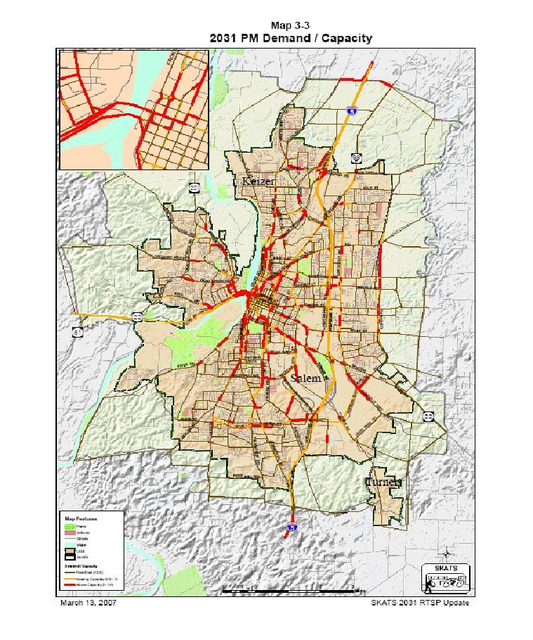
20 -14-
21 Updated Project Costs Methodology for Determining Project Costs and TSDC Eligibility Once the system capacity deficiencies have been identified and reflected as projects in the adopted Salem TSP, the projects are then evaluated to determine if they meet the growth and time-of-deficiency criteria needed to make them TSDC-eligible projects. The projects are then assigned to one of three categories: Corridor Capacity Projects: These projects add new through travel lane capacity on arterial and collector streets, including center turn lanes, and acceleration and deceleration lanes. They also include new arterial and collector streets that the City would anticipate building itself, independent of the development process. (See Appendix A, Table A-1) Standard Street Upgrade Projects: These are improvements to existing arterial and collector streets located outside the Urban Services Area (USA) that add urban street components such as proper pavement depth, lane width, curb, gutter, storm drainage, sidewalks, street lights, and bicycle lanes (on specific streets as identified in the Salem TSP). They also include new arterial and collector streets that the City would anticipate being constructed as part of the development process. Only the portion of the projects that add pavement right-of-way, depth and width are TSDC-eligible. (See Appendix A, Table A-2) Traffic Signal System and Intersection Improvement Projects: These projects add capacity to the system through the installation of new traffic signals, upgrading of existing traffic signals, installation and upgrade of traffic signal interconnection, coordination and communication systems, and the construction of dedicated left and right turn lanes, additional through travel lanes, and any other improvements to intersections that improve vehicular capacity. (See Appendix A, Table A-3) The following methodologies are used to calculate the percentage of eligibility for each of the above project categories: Corridor Capacity Projects Appendix A, Table A-1 lists the identified Corridor Capacity Projects identified from 1995 through 2031 travel demand. This table provides project descriptions, including existing pavement width, and estimated TSDC and Non-TSDC costs for each project. The estimated total project -15-
22 costs were derived by taking the planning level cost estimate for the project, adjusted to 2006 dollars, and multiplying it by the ratio of new additional pavement needed to mitigate the additional travel demand attributed to growth. Specifically, all additional right-of-way costs are TSDC eligible, as well as all additional pavement, bridge and culvert expansions, installation of needed storm drainage systems (curb, gutter, catch basin to pipe systems or open ditch/swale systems), required water quality systems, and the cost of replacing existing pavement, curb, gutter, drainage, sidewalk, bicycle lanes, landscaping and street lighting needed to be moved or reconstructed due to having to expand the roadway section, or it beign damaged by constructing the improvement. Example #1: Widen a Major Arterial street from an existing cross-section of two travel lanes and gravel shoulders with open drainage (existing pavement width 28 feet) to four travel lanes, plus add a continuous center turn lane, sidewalks, curb, gutter, drainage, landscaping, and street lights (new pavement width 68 feet), for a distance of 5,000 feet. Total Planning Level Cost Estimate for Project: $5,000,000 New Pavement Width - Existing Pavement Width = New Capacity Improvement 68 ft ft. = 40 ft. therefore 40/68 = or 58.8% of the Total Planning Level Cost Estimate is TSDC Eligible $5,000,000 x.588 = $2,940,000 TSDC-Eligible Project Costs $2,060,000 Non-TSDC Eligible Project Costs Example #2: Widen a Major Arterial street, fully improved to urban standards, from an existing cross-section of two travel lanes, continuous center turn lane and bicycle lanes (existing pavement width 46 feet) to four travel lanes, plus a continuous center turn lane, and bicycle lanes and all other urban standard components. (new pavement width 68 feet) with a widened bridge 100 feet long, for a total corridor distance of 5,000 feet. Total Planning Level Cost Estimate for Project: $8,000,000 New Pavement Width - Existing Pavement Width = New Capacity Improvement 68 ft ft. = 22 ft. therefore 22/68 = or 32.4% of the Total Planning Level Cost Estimate is initially TSDC Eligible $8,000,000 x.324 = $2,592,000 initially TSDC-Eligible Project Cost...plus cost of widening bridge to accommodate extra lanes: $2,500,000...plus cost of replacing existing urban standard components: $1,500,000 $2,592,000 + $2,500,000 + $1,500,000 = $6,592,000 or 82.4% TSDC Eligibility $1,408,000 or 17.6% Non-TSDC Eligible Example #3 City determines it needs to build a new Minor Arterial street connection (72 ft. ROW, pavement width 46 ft.) to full urban standards, independent of the private development process. This connection will alleviate congestion on nearby arterial streets that will reach capacity deficient levels within the TSDC planning period. Project includes purchase of right-of-way, street construction, and building a bridge over a creek 100 feet in length. Total length of project is 3,000 feet. Total Planning Level Cost Estimate for Project: $10,320,000 Total Right-of-Way Costs: 72 ft. width x 3,000 ft. length x $30 sq.ft = $6,480,000 TSDC Right-of-Way Costs: $6,480,000 (100% eligible) -16-
23 Total Street Costs: 2,900 ft. x $820 = $2,460,000 TSDC Street Costs: $2,460,000 (100% eligible) Total Bridge Costs: 100 ft. long x 46 ft. wide x $300 sq. ft. = $1,380,000 TSDC Bridge Costs: $1,380,000 (100% eligible) Total TSDC Eligible Costs: $10,320,000 (100% eligible) Standard Street Upgrade Projects (Outside the USA) Appendix A, Table A-2 lists the identified projects needed to upgrade arterial and collector streets located outside the Urban Service Area (USA) to full urban standards. It is assumed that developers will be responsible for providing streets to serve the undeveloped areas, as they are developed. However, the developers will be required to provide only a local street s level of improvement, with any extra costs to upgrade to collector or arterial streets being eligible for TSDC funding. The projects in the list include: upgrading the street pavement to proper depth and lane width per the City s Street Design Standards and Salem TSP requirements; needed additional right-of-way, installing bicycle lanes where designated in the Salem TSP; and constructing curb, gutter, storm drainage, sidewalk, landscaping, and street lights. Basic unit costs for constructing the street per its functional classification are listed below. The allocation of TSDC costs were made by applying the difference in unit costs between providing a local street and the unit cost for an arterial or collector street. These cost differences are for extra pavement width and pavement thickness to support more frequent and heavier loads. Thus, the increment in street costs for the TSDC share of street standard upgrades outside the USA are calculated on the following unit costs: Table 3 Basic Unit Costs for Street Improvements by Functional Classification in 2006 dollars Functional Classification Pavement Width Cost/Lineal Foot Difference to Local Cost/Lin. Ft. Parkway 80 feet $1,100 Parkway - Local $560 Major Arterial 68 feet $1,000 Major Arterial - Local $460 Minor Arterial 46 feet $820 Minor Arterial - Local $280 Collector A & C 34 feet $620 Collector A & C - Local $80 Collector B 40 feet $670 Collector B - Local $130 Local 30 feet $540 *Collector B has additional parking on one side, plus bicycle lanes on both sides. Eligible bridge costs are those costs estimated necessary to widen the structure to account for the upgrade in pavement width. The estimated cost in 2006 dollars for bridge construction is $300 per square foot of bridge deck. Right-of-way costs eligible for TSDC funding are those costs of providing additional width over the local street standard width of 60 feet. In some cases outside the USA, developers will be required to provide the entire right-of-way (even in excess of 60 feet). However, in other cases, the City will be required to purchase the additional right-of-way. To -17-
24 account for both cases, 50 percent of the cost of extra right-of-way has been included in the TSDC cost category. Right-of-way purchase costs (in 2006 dollars) are estimated at $10 per square foot for undeveloped residential land and $30 per square foot for commercial/industrial. Example #1 Developer upgrades an existing local street, outside the USA, (pavement width 30 feet, no curb, gutter, sidewalk) to its new classification as a Minor Arterial street (pavement width 46 feet, with curb, gutter, sidewalk, storm drainage, landscaping, and street lights) for 1,000 feet, plus widening an existing bridge that is 50 feet long. Total Street Cost: 1,000 ft. x $820 = $820,000 TSDC Street Cost: 1,000 ft. x $280 = $280,000 Non-TSDC Street Cost: $820,000 - $280,000 = $540,000 Right-of-Way Costs: 1,000 ft. x (72 ft ft.) x $10 sq. ft. = $120,000 TSDC ROW Cost:.50 x $120,000 = $60,000 Non-TSDC ROW Costs: $120,000 - $60,000 = $60,000 Total Bridge Costs: 46 ft. wide x 50 ft. long x $300 sq. ft. = $690,000 TSDC Bridge Cost: (46 ft ft.) x 50 ft. x $300 = $180,000 Non-TSDC Bridge Cost: $690,000 - $180,000 = $510,000 Total Project Cost: $820,000 + $120,000 + $690,000 = $1,630,000 Total TSDC Cost: $280,000 + $60,000 + $180,000 = $520,000 Total Non-TSDC Cost: $540,000 + $60,000 + $510,000 = $1,110,000 Example #2 Developer extends a new collector street, outside the USA, (ROW 60 ft. wide, pavement width 34 ft.) per the requirements of the Salem TSP as part of a new subdivision in undeveloped land. Street is built to full urban standards. A bridge 75 ft. long is needed to cross a creek. Total project street length is 2,000 feet. Total Street Cost: 2,000 ft. x $620 = $1,240,000 TSDC Street Cost: 2,000 ft. x $80 = $160,000 Non-TSDC Street Cost: $1,240,000 - $160,000 = $1,080,000 Right-of-Way Costs: 2,000 ft. x (60 ft ft.) x $10 sq. ft. = $0 TSDC ROW Cost: $0 Non-TSDC ROW Costs: $0 (Dedicated to City as ROW) Total Bridge Costs: 34 ft. wide x 75 ft. long x $300 sq. ft. = $765,000 TSDC Bridge Cost: (34 ft ft.) x 75 ft. x $300 = $90,000 Non-TSDC Bridge Cost: $765,000 - $90,000 = $675,000 Total Project Cost: $1,240,000 + $0 + $765,000 = $2,005,000 Total TSDC Cost: $160,000 + $0 + $90,000 = $250,000 Total Non-TSDC Cost: $1,080,000 + $0 + $675,000 = $1,755,
Parks and Transportation System Development Charge Methodology
 City of Sandy Parks and Transportation System Development Charge Methodology March, 2016 Background In order to implement a City Council goal the City of Sandy engaged FCS Group in January of 2015 to update
Parking Management Element
 Parking Management Element The State Transportation Planning Rule, adopted in 1991, requires that the Metropolitan Planning Organization (MPO) area implement, through its member jurisdictions, a parking
CEDAR AVENUE TRANSITWAY Implementation Plan Update
 CEDAR AVENUE TRANSITWAY Implementation Plan Update EECUTIVE SUMMARY DECEMBER 2015 Executive Summary In 2013, the Twin Cities metropolitan area s first bus rapid transit (BRT) line, the METRO Red Line,
2030 Multimodal Transportation Study
 2030 Multimodal Transportation Study City of Jacksonville Planning and Development Department Prepared by Ghyabi & Associates April 29,2010 Introduction Presentation Components 1. Study Basis 2. Study
TABLE OF CONTENTS EXECUTIVE SUMMARY...1 INTRODUCTION...3 PROJECTED FUTURE GROWTH...3 ROADWAY IMPROVEMENT PROJECTS...4 POTENTIAL FUNDING SOURCES...
 Transportation Impact Fee Study September 2014 TABLE OF CONTENTS EXECUTIVE SUMMARY...1 INTRODUCTION...3 PROJECTED FUTURE GROWTH...3 ROADWAY IMPROVEMENT PROJECTS......4 POTENTIAL FUNDING SOURCES...7 PROPOSED
City of Lake Oswego Transportation System Plan Update PLAN AND POLICY REVIEW, PART 1
 City of Lake Oswego Transportation System Plan Update PLAN AND POLICY REVIEW, PART 1 Date: March 7, 2012 Project #: 11187 To: Cc: From: Project: Subject: Project Management Team Transportation System Plan
Transportation. Background. Transportation Planning Goals. Level of Service Analysis 5-1
 Transportation portion of the city s stormwater utility, and state road and fuel taxes. Background The transportation needs of the City of Lacey and its planning areas are met by a growing multimodal network
Town of Londonderry, New Hampshire NH Route 28 Western Segment Traffic Impact Fee Methodology
 Town of Londonderry, New Hampshire NH Route 28 Western Segment Traffic Impact Fee Methodology Prepared by the Londonderry Community Development Department Planning & Economic Development Division Based
City of Grand Forks Staff Report
 City of Grand Forks Staff Report Service/Safety Committee December 15, 2015 City Council December 21, 2015 Agenda Item: Amendment No. 1 to Engineering Services Agreement with CPS for City Project No. 7143,
Transportation Statistical Data Development Report BAY COUNTY 2035 LONG RANGE TRANSPORTATION PLAN
 Transportation Statistical Data Development Report BAY COUNTY 2035 LONG RANGE TRANSPORTATION PLAN Prepared for Bay County Transportation Planning Organization and The Florida Department of Transportation,
ACTION TRANSMITTAL No
 Transportation Advisory Board of the Metropolitan Council of the Twin Cities DATE: January 4, 2016 TO: ACTION TRANSMITTAL No. 2016-19 TAC Funding and Programming Committee PREPARED BY: Joe Barbeau, Senior
US 29 Bus Rapid Transit Planning Board Briefing. February 16, 2017
 US 29 Bus Rapid Transit Planning Board Briefing February 16, 2017 Project Goals Improve the quality of transit service Improve mobility opportunities and choices Enhance quality of life Support master
Tulsa Transportation Management Area. Urbanized Area Surface Transportation Program
 Tulsa Transportation Management Area Urbanized Area Surface Transportation Program FFY 2022 Application Information Sponsor Location Description STP Request Other Funds Broken Arrow Elm Place: Kenosha
5. HORIZON YEAR TRANSPORTATION MASTER PLAN-COST ESTIMATES
 5. HORIZON YEAR TRANSPORTATION MASTER PLAN-COST ESTIMATES 5.1 INTRODUCTION This chapter of the TMP presents an opinion of probable cost estimates for the proposed Horizon Year roadway network improvements
Dixie Transportation Planning Office
 A project must be given a yes rating on items 1 & 2 in order to be prioritized. Sponsor: St. George City Project: Pioneer Parkway Type: Road Widening and Reconstruction Rev. 9/17/2010 Dixie Transportation
Point A Point B Point C Point D. Fulton County Board of Commissioners and Mayors Meeting December 14, 2017
 Fulton County Board of Commissioners and Mayors Meeting December 14, 2017 Master Plan Overview Phase 1 Community Vision and Existing Transit Conditions Phase 2 Scenario Development Phase 3 Transit Master
6/6/2018. June 7, Item #1 CITIZENS PARTICIPATION
 June 7, 2018 Item #1 CITIZENS PARTICIPATION 1 Item #2 APPROVAL OF MINUTES Item #3 TRAC GOALS, FRAMEWORK & AGENDA REVIEW 2 COMMITTEE GOALS Learn about Southern Nevada s mobility challenges, new developments
4 COSTS AND OPERATIONS
 4 COSTS AND OPERATIONS 4.1 INTRODUCTION This chapter summarizes the estimated capital and operations and maintenance (O&M) costs for the Modal and High-Speed Train (HST) Alternatives evaluated in this
3.17 Energy Resources
 3.17 Energy Resources 3.17.1 Introduction This section characterizes energy resources, usage associated with the proposed Expo Phase 2 project, and the net energy demand associated with changes to the
Funding Scenario Descriptions & Performance
 Funding Scenario Descriptions & Performance These scenarios were developed based on direction set by the Task Force at previous meetings. They represent approaches for funding to further Task Force discussion
Public Works and Infrastructure Committee. General Manager, Transportation Services and Treasurer. P:\2015\Internal Services\rev\pw15018rev (AFS20761)
") Increases to Parking Ticket Set Fines STAFF REPORT ACTION REQUIRED Date: September 14, 2015 To: From: Wards: Reference Number: Public Works and Infrastructure Committee General Manager, Transportation
Increases to Parking Ticket Set Fines STAFF REPORT ACTION REQUIRED Date: September 14, 2015 To: From: Wards: Reference Number: Public Works and Infrastructure Committee General Manager, Transportation
CITY OF LONDON STRATEGIC MULTI-YEAR BUDGET ADDITIONAL INVESTMENTS BUSINESS CASE # 6
 2016 2019 CITY OF LONDON STRATEGIC MULTI-YEAR BUDGET ADDITIONAL INVESTMENTS BUSINESS CASE # 6 STRATEGIC AREA OF FOCUS: SUB-PRIORITY: STRATEGY: INITIATIVE: INITIATIVE LEAD(S): BUILDING A SUSTAINABLE CITY
MASTER THOROUGHFARE PLAN
 MASTER THOROUGHFARE PLAN Roadway Impact Fee July 2016 Prepared for Town of Northlake HALFF ASSOCIATES, INC. ENGINEERS SURVEYORS SCIENTISTS TBPE #F-312 PRELIMINARY FOR INTERIM REVIE ONLY These documents
Draft Results and Open House
 Waco Rapid Transit Corridor (RTC) Feasibility Study Draft Results and Open House Chris Evilia, Director of Waco Metropolitan Planning Organization Allen Hunter, General Manager Waco Transit System Jimi
Waco Rapid Transit Corridor (RTC) Feasibility Study
 Feasibility Study") Waco Rapid Transit Corridor (RTC) Feasibility Study Chris Evilia, Director of Waco Metropolitan Planning Organization Allen Hunter, General Manager Waco Transit System Jimi Mitchell, Project Manager AECOM
Waco Rapid Transit Corridor (RTC) Feasibility Study Chris Evilia, Director of Waco Metropolitan Planning Organization Allen Hunter, General Manager Waco Transit System Jimi Mitchell, Project Manager AECOM
Improving Accessibility of Regional Bus Stops and Pathways
 Customer Service and Operations Committee Board Information Item III-A March 13, 2014 Improving Accessibility of Regional Bus Stops and Pathways Page 3 of 17 Washington Metropolitan Area Transit Authority
Task Force Meeting January 15, 2009
 Task Force Meeting January 15, 2009 Study Update August 14 th Task Force Meeting Update on Traffic Projections and Financial Feasibility Study presented by Kane County and WSA staff The presentation summarized
Central City Line Locally Preferred Alternative (LPA) Amendment Public Hearing. July 24, 2014
 Amendment Public Hearing. July 24, 2014") Central City Line Locally Preferred Alternative (LPA) Amendment Public Hearing July 24, 2014 Project Description The Central City Line is a High Performance Transit project that will extend from Browne
Central City Line Locally Preferred Alternative (LPA) Amendment Public Hearing July 24, 2014 Project Description The Central City Line is a High Performance Transit project that will extend from Browne
Draft Results and Recommendations
 Waco Rapid Transit Corridor (RTC) Feasibility Study Draft Results and Recommendations Chris Evilia, Director of Waco Metropolitan Planning Organization Allen Hunter, General Manager Waco Transit System
Mobility 2045 Plan Workshop
 Mobility 2045 Plan Workshop Regional Transportation Council October 12, 2017 Agenda Mobility Planning Mobility 2045 Innovative Funding and Strategic Partnerships Public Outreach Efforts Next Steps 2 Mobility
ANDERSON PROPERTY SITE ANALYSIS
 ANDERSON PROPERTY SITE ANALYSIS Introduction The Montgomery County Department of Transportation (MCDOT) initiated a feasibility study in the fall of 2012 to evaluate the need for transit service expansion
Rocky Mount. Transportation Plan. Transportation Planning Division. Virginia Department of Transportation
 2020 Transportation Plan Developed by the Transportation Planning Division of the Virginia Department of Transportation in cooperation with the U.S. Department of Transportation, Federal Highway Administration
CAPITAL FUND 9510 STREET & SIDEWALK IMPROVEMENTS FIVE-YEAR CAPITAL IMPROVEMENT PROGRAM FISCAL YEARS
 9510 STREET & SIDEWALK IMPROVEMENTS FIVE-YEAR CAPITAL IMPROVEMENT PROGRAM FISCAL YEARS 2019-2023 9510 STREET & SIDEWALK IMPROVEMENTS - 01 STREET AND SIDEWALK MAINTENANCE PROGRAM $1,250,000 $0 $1,250,000
Street Lighting Policy. Revision
 Street Lighting Policy Revision 5-2017 Grand Chute Street Lighting Policy - 1 - May 2, 2017 Intent: The intent of this policy is to outline the Town of Grand Chute s standards for the installation and
POLICIES FOR THE INSTALLATION OF SPEED HUMPS (Amended May 23, 2011)
") (Amended May 23, 2011) 1. Speed humps are an appropriate mechanism for reducing speeds on certain streets in Pasadena when properly installed under the right circumstances. 2. Speed humps can be considered
(Amended May 23, 2011) 1. Speed humps are an appropriate mechanism for reducing speeds on certain streets in Pasadena when properly installed under the right circumstances. 2. Speed humps can be considered
EUGENE-SPRINGFIELD, OREGON EAST WEST PILOT BRT LANE TRANSIT DISTRICT
 EUGENE-SPRINGFIELD, OREGON EAST WEST PILOT BRT LANE TRANSIT DISTRICT (BRIEF) Table of Contents EUGENE-SPRINGFIELD, OREGON (USA)... 1 COUNTY CONTEXT AND SYSTEM DESCRIPTION... 1 SYSTEM OVERVIEW... 1 PLANNING
Transportation Sustainability Program
 Transportation Sustainability Program Photo: Sergio Ruiz San Francisco 2016 Roads and public transit nearing capacity Increase in cycling and walking despite less than ideal conditions 2 San Francisco
SPEED HUMP POLICY and PROCEDURES for RESIDENTIAL AREAS
 SPEED HUMP POLICY and PROCEDURES for RESIDENTIAL AREAS City of Panama City, Florida Public Works Department 9 Harrison Avenue Panama City, Florida 32401 Phone: (850) 872-3015 Effective 1/22/08 Table of
Office of Transportation Bureau of Traffic Management Downtown Parking Meter District Rate Report
 Office of Transportation Bureau of Traffic Management 1997 Downtown Parking Meter District Rate Report Introduction The City operates approximately 5,600 parking meters in the core area of downtown. 1
The Eastern Connector Study November, 2007 planning for the future
 The Eastern Connector Study November, 2007 planning for the future In late 2006, Albemarle County and the City of Charlottesville jointly initiated the Eastern Connector Corridor Study. The Project Team
FREQUENTLY ASKED QUESTIONS
 FREQUENTLY ASKED QUESTIONS 2018 What is the More MARTA Atlanta program? The More MARTA Atlanta program is a collaborative partnership between MARTA and the City of Atlanta to develop and implement a program
Transportation Demand Management Element
 Transportation Demand Management Element Over the years, our reliance on the private automobile as our primary mode of transportation has grown substantially. Our dependence on the automobile is evidenced
ARLINGTON COUNTY, VIRGINIA. County Board Agenda Item Meeting of February 24, 2018
 ARLINGTON COUNTY, VIRGINIA County Board Agenda Item Meeting of February 24, 2018 DATE: February 20, 2018 SUBJECT: Request to authorize advertisement of a public hearing to consider an amendment to Section
5. OPPORTUNITIES AND NEXT STEPS
 5. OPPORTUNITIES AND NEXT STEPS When the METRO Green Line LRT begins operating in mid-2014, a strong emphasis will be placed on providing frequent connecting bus service with Green Line trains. Bus hours
TRAFFIC MANAGEMENT STANDARDS CITY OF GARLAND TRANSPORTATION DEPARTMENT
 TRAFFIC MANAGEMENT STANDARDS CITY OF GARLAND TRANSPORTATION DEPARTMENT JUNE 1996 TABLE OF CONTENTS 1.0 Street Design Standards 1.1 Right-of-Way Requirements 1.2 Median Openings 1.3 Sidewalks 1.4 Traffic
Appendix C. Parking Strategies
 Appendix C. Parking Strategies Bremerton Parking Study Introduction & Project Scope Community concerns regarding parking impacts in Downtown Bremerton and the surrounding residential areas have existed
Exhibit A Sound Transit Board Resolution R Selecting the bicycle, pedestrian, and parking access improvements to be built for the Puyallup
 Exhibit A Sound Transit Board Resolution R2016-07 Selecting the bicycle, pedestrian, and parking access improvements to be built for the Puyallup Access Improvement Project. RESOLUTION NO. R2016-07 Selecting
TIMBERVINE TRANSPORTATION IMPACT STUDY FORT COLLINS, COLORADO JANUARY Prepared for:
 TIMBERVINE TRANSPORTATION IMPACT STUDY FORT COLLINS, COLORADO JANUARY 2014 Prepared for: Hartford Companies 1218 W. Ash Street Suite A Windsor, Co 80550 Prepared by: DELICH ASSOCIATES 2272 Glen Haven Drive
4.0 TIER 2 ALTERNATIVES
 4.0 TIER 2 ALTERNATIVES The Tier 2 Alternatives represent the highest performing Tier 1 Alternatives. The purpose of the Tier 2 Screening was to identify the LPA utilizing a more robust list of evaluation
Travel Forecasting Methodology
 Travel Forecasting Methodology Introduction This technical memorandum documents the travel demand forecasting methodology used for the SH7 BRT Study. This memorandum includes discussion of the following:
Proposed FY Capital Improvement Program (CIP) March 5, 2018 Capital Planning Committee 1
 March 5, 2018 Capital Planning Committee 1") Proposed FY 2019-2023 Capital Improvement Program (CIP) March 5, 2018 Capital Planning Committee 1 The Capital Improvement Program is: A fiscally constrained, 5-year program of capital projects An implementation
Proposed FY 2019-2023 Capital Improvement Program (CIP) March 5, 2018 Capital Planning Committee 1 The Capital Improvement Program is: A fiscally constrained, 5-year program of capital projects An implementation
Transportation Committee Revised Project Scope and Cost Estimate. November 23, 2015
 Transportation Committee Revised Project Scope and Cost Estimate November 23, 2015 1 Today s Topics Revised Project Scope Revised Cost Estimate Municipal Approval Action 2 3 Revised Project Scope Project
City of Palo Alto (ID # 6416) City Council Staff Report
 City Council Staff Report") City of Palo Alto (ID # 6416) City Council Staff Report Report Type: Informational Report Meeting Date: 1/25/2016 Summary Title: Update on Second Transmission Line Title: Update on Progress Towards Building
City of Palo Alto (ID # 6416) City Council Staff Report Report Type: Informational Report Meeting Date: 1/25/2016 Summary Title: Update on Second Transmission Line Title: Update on Progress Towards Building
ELMORE COUNTY HIGHWAY DEPARTMENT
 Adopted 11/27/06 Effective 2/1/07 Amended 4/10/08 ELMORE COUNTY HIGHWAY DEPARTMENT 155 County Shop Road Wetumpka, Alabama 36092 Phone (334) 567-1162 Fax (334) 567-1100 Access Management Policy The Elmore
2030 Comprehensive Plan Goals, Objectives, and Policies Mobility Working Document
 TRANSPORTATION ELEMENT 2030 Comprehensive Plan Goals, Objectives, and Policies Mobility Working Document GOAL 1 The City shall utilize Quality/Level of Service standards which meet the Florida Department
Subarea Study. Manning Avenue (CSAH 15) Corridor Management and Safety Improvement Project. Final Version 1. Washington County.
 Corridor Management and Safety Improvement Project. Final Version 1. Washington County.") Subarea Study Manning Avenue (CSAH 15) Corridor Management and Safety Improvement Project Final Version 1 Washington County June 12, 214 SRF No. 138141 Table of Contents Introduction... 1 Forecast Methodology
Subarea Study Manning Avenue (CSAH 15) Corridor Management and Safety Improvement Project Final Version 1 Washington County June 12, 214 SRF No. 138141 Table of Contents Introduction... 1 Forecast Methodology
Energy Technical Memorandum
 Southeast Extension Project Lincoln Station to RidgeGate Parkway Prepared for: Federal Transit Administration Prepared by: Denver Regional Transportation District May 2014 Table of Contents Page No. Chapter
Operating & Maintenance Cost Results Report
 Operating & Maintenance Cost Results Report Prepared for: Hennepin County Regional Railroad Authority Prepared by: Connetics Transportation Group Under Contract To: Kimley-Horn and Associates FINAL June
Merger of the generator interconnection processes of Valley Electric and the ISO;
 California Independent System Operator Corporation Memorandum To: ISO Board of Governors From: Karen Edson Vice President, Policy & Client Services Date: August 18, 2011 Re: Decision on Valley Electric
Right-of-Way Obstruction Permit Fee Structure Minneapolis Department of Public Works May 10, 2001
 Right-of-Way Obstruction Permit Fee Structure Minneapolis Department of Public Works May 10, 2001 Revised April 5, 2005 Revised January 27, 2006 Prepared by: Steve Collin, Engineer 2.5 Revised by Douglas
STH 60 Northern Reliever Route Feasibility Study Report
 #233087 v3 STH 60 Northern Reliever Route Feasibility Study Report Washington County Public Works Committee Meeting September 28, 2016 1 STH 60 Northern Reliever Route Feasibility Study Hartford Area Development
Alpine Highway to North County Boulevard Connector Study
 Alpine Highway to North County Boulevard Connector Study prepared by Avenue Consultants March 16, 2017 North County Boulevard Connector Study March 16, 2017 Table of Contents 1 Summary of Findings... 1
RURAL ROAD MAINTENANCE POLICY
 Government of Yukon RURAL ROAD MAINTENANCE POLICY (Updated April 01, 2003 to reflect Department name change from Infrastructure to Highways and Public Works. No change to Policy.) November 1991 TABLE OF
Public Information Workshop
 Public Information Workshop Charlotte County-Punta Gorda MPO - Meeting Rooms A and B March 29, 2018 Welcome to the Public Information Workshop for Harborview Road Project Development and Environment (PD&E)
SPEED CUSHION POLICY AND INSTALLATION PROCEDURES FOR RESIDENTIAL STREETS
 SPEED CUSHION POLICY AND INSTALLATION PROCEDURES FOR RESIDENTIAL STREETS CITY OF GRAND PRAIRIE TRANSPORTATION SERVICES DEPARTMENT SPEED CUSHION INSTALLATION POLICY A. GENERAL Speed cushions are an effective
CITY OF ANN ARBOR, MICHIGAN 301 E. Huron St., P.O. Box 8647 Ann Arbor, Michigan
 Date: Wednesday, June 24, 2014 Location: Ann Arbor District Library Attendees: 40 citizen attendees Ann Arbor Station Environmental Review Public Meeting Meeting Notes Meeting #2 The second public meeting
2. Valley Circle Boulevard/Andora Avenue/Baden Avenue and Lassen Street
 IV.J TRANSPORTATION 1. INTRODUCTION This section presents an overview of the existing traffic and circulation system in and surrounding the project site. This section also discusses the potential impacts
Table of Contents INTRODUCTION... 3 PROJECT STUDY AREA Figure 1 Vicinity Map Study Area... 4 EXISTING CONDITIONS... 5 TRAFFIC OPERATIONS...
 Crosshaven Drive Corridor Study City of Vestavia Hills, Alabama Table of Contents INTRODUCTION... 3 PROJECT STUDY AREA... 3 Figure 1 Vicinity Map Study Area... 4 EXISTING CONDITIONS... 5 TRAFFIC OPERATIONS...
CHAPTER 9: VEHICULAR ACCESS CONTROL Introduction and Goals Administration Standards
 9.00 Introduction and Goals 9.01 Administration 9.02 Standards 9.1 9.00 INTRODUCTION AND GOALS City streets serve two purposes that are often in conflict moving traffic and accessing property. The higher
Draft Marrickville Car Share Policy 2014
 Draft Marrickville Car Share Policy 2014 1. Background 1.1. Marrickville Council has supported car sharing in the LGA since 2007 as part of a holistic approach to encouraging more sustainable modes of
SOUTHERN GATEWAY. Transportation and Trinity River Project Committee 11 May 2015
 SOUTHERN GATEWAY Transportation and Trinity River Project Committee 11 May 2015 Southern Gateway Project History Began in 2001 as a Major Investment Study [ MIS ], Schematic, and Environmental Assessment
Broward County Intermodal Center And People Mover. AASHTO Value Engineering Conference Presentation. September 1, 2009 San Diego, CA
 Project Development & Environment Study Broward County Intermodal Center And People Mover AASHTO Value Engineering Conference Presentation September 1, 2009 San Diego, CA Background P D & E Study Regional
Policy Note. Vanpools in the Puget Sound Region The case for expanding vanpool programs to move the most people for the least cost.
 Policy Note Vanpools in the Puget Sound Region The case for expanding vanpool programs to move the most people for the least cost Recommendations 1. Saturate vanpool market before expanding other intercity
ENERGY STRATEGY FOR YUKON. Independent Power Production Policy
 ENERGY STRATEGY FOR YUKON Independent Power Production Policy May 20, 2014 Page 2 of 11 BACKGROUND The Government of Yukon released the Energy Strategy for Yukon in January 2009. The strategy sets out
PUBLIC Law, Chapter 539 LD 1535, item 1, 124th Maine State Legislature An Act To Create a Smart Grid Policy in the State
 PLEASE NOTE: Legislative Information cannot perform research, provide legal advice, or interpret Maine law. For legal assistance, please contact a qualified attorney. Emergency preamble. Whereas, acts
Business Advisory Committee. November 3, 2015
 Business Advisory Committee November 3, 2015 1 Today s Topics DEIS Cost Estimate 2 Assumptions Revised Cost Estimate Revised Project Scope Cost Estimate Overview Position Statement Discussion Municipal
Mississauga Bus Rapid Transit Preliminary Design Project
 Mississauga Bus Rapid Transit Preliminary Design Project PUBLIC INFORMATION CENTRE OCTOBER 2008 WELCOME The Mississauga Bus Rapid Transit (BRT) Project Thank you for attending this Public Information Centre.
Open House. Highway212. Meetings. Corridor Access Management, Safety & Phasing Plan. 5:30 to 6:30 p.m. - Southwest Corridor Transportation Coalition
 Welcome Meetings 5:30 to 6:30 p.m. - Southwest Corridor Transportation Coalition 6:30 to 8:00 p.m. - Open House Why is Highway 212 Project Important? Important Arterial Route Local Support Highway 212
P. SUMMARY: The Southeastern Power Administration (SEPA) establishes Rate Schedules JW-
 establishes Rate Schedules JW-") This document is scheduled to be published in the Federal Register on 08/29/2016 and available online at http://federalregister.gov/a/2016-20620, and on FDsys.gov 6450-01-P DEPARTMENT OF ENERGY Southeastern
This document is scheduled to be published in the Federal Register on 08/29/2016 and available online at http://federalregister.gov/a/2016-20620, and on FDsys.gov 6450-01-P DEPARTMENT OF ENERGY Southeastern
Rapid Transit and Land-Use Integration a Reality
 City of Charlotte Rapid Transit and Land-Use Integration a Reality Transportation Oversight Committee Carolyn Flowers CEO Charlotte Area Transit System April 29, 2010 Charlotte Region Statistics Mecklenburg
Traffic Engineering Study
 Traffic Engineering Study Bellaire Boulevard Prepared For: International Management District Technical Services, Inc. Texas Registered Engineering Firm F-3580 November 2009 Executive Summary has been requested
Leadership NC. November 8, 2018
 v Leadership NC November 8, 2018 Planning for our region s growth The Triangle is one of the fastestgrowing regions in the nation. More than 2 million people are already part of the equation, and the
Kendall Drive Premium Transit PD&E Study Project Kick-Off Meeting SR 94/Kendall Drive/SW 88 Street Project Development and Environment (PD&E) Study
 Study") Florida Department of Transportation District Six Kendall Drive Premium Transit PD&E Study Project Kick-Off Meeting SR 94/Kendall Drive/SW 88 Street Project Development and Environment (PD&E) Study What
Florida Department of Transportation District Six Kendall Drive Premium Transit PD&E Study Project Kick-Off Meeting SR 94/Kendall Drive/SW 88 Street Project Development and Environment (PD&E) Study What
A Guide to the medium General Service. BC Hydro Last Updated: February 24, 2012
 A Guide to the medium General Service Conservation Rate BC Hydro Last Updated: February 24, 2012 Executive summary The way Medium General Service (MGS) accounts pay for electricity is changing. MGS is
The Boston South Station HSIPR Expansion Project Cost-Benefit Analysis. High Speed Intercity Passenger Rail Technical Appendix
 The Boston South Station HSIPR Expansion Project Cost-Benefit Analysis High Speed Intercity Passenger Rail Technical Appendix Prepared by HDR August 5, 2010 The Boston South Station HSIPR Expansion Project
EXECUTIVE SUMMARY. The following is an outline of the traffic analysis performed by Hales Engineering for the traffic conditions of this project.
 EXECUTIVE SUMMARY This study addresses the traffic impacts associated with the proposed Shopko redevelopment located in Sugarhouse, Utah. The Shopko redevelopment project is located between 1300 East and
ARTICLE 8 OFF-STREET PARKING AND PRIVATE DRIVEWAY STANDARDS
 ARTICLE 8 OFF-STREET PARKING AND PRIVATE DRIVEWAY STANDARDS TABLE OF CONTENTS SECTION PAGE 8.1 GENERAL STANDARDS...8-2 8.2 PRIVATE DRIVEWAY PROVISIONS...8-4 8.3 OFF-STREET PARKING STANDARDS...8-5 8.4 OFF-STREET
SAN RAFAEL CITY COUNCIL AGENDA REPORT
 Agenda Item No: 8.b Meeting Date: December 19, 2016 Department: PUBLIC WORKS SAN RAFAEL CITY COUNCIL AGENDA REPORT Prepared by: Bill Guerin, Public Works Director City Manager Approval: File No.: 18.01.79
Alternatives Analysis Findings Report
 6.0 This chapter presents estimates of the potential capital, operations and maintenance costs associated with the alternatives carried forward for detailed evaluation. The methodology used to develop
Purpose and Need Report
 Purpose and Need Report State Highway (SH) 29 From Southwestern Boulevard to SH 95 Williamson County, Texas (CSJ: 0337-02-045) Prepared by Blanton & Associates, Inc. Date: November, 2015 The environmental
New Buck O Neil (U. S. 169) Crossing Benefit-Cost Analysis. Kansas City, Missouri
 Crossing Benefit-Cost Analysis. Kansas City, Missouri") New Buck O Neil (U. S. 169) Crossing Benefit-Cost Analysis Kansas City, Missouri New Buck O Neil (U. S. 169) Crossing Benefit-Cost Analysis prepared for Kansas City, Missouri prepared by Burns & McDonnell
New Buck O Neil (U. S. 169) Crossing Benefit-Cost Analysis Kansas City, Missouri New Buck O Neil (U. S. 169) Crossing Benefit-Cost Analysis prepared for Kansas City, Missouri prepared by Burns & McDonnell
Green Line Long-Term Investments
 Enhancements Short-term improvements to keep Austin moving. Investments Long-term projects to support our future. Mobility Hubs MetroRapid MetroRail MetroExpress Connectors Circulators Project Connect
Charlotte-Mecklenburg Region Rapid Transit and Land-Use Integration
 Charlotte-Mecklenburg Region Rapid Transit and Land-Use Integration Legislative Committee on Urban Growth and Infrastructure Carolyn Flowers CEO Charlotte Area Transit System March 23, 2010 Charlotte Region
Applicable California Vehicle Code Sections, 2015 Edition
 Applicable California Vehicle Code Sections, 2015 Edition Speed limits in California are governed by the California Vehicle Code (CVC), Sections 22348 through 22413; also, pertinent sections are found
TRAVEL DEMAND FORECASTS
 Jiangxi Ji an Sustainable Urban Transport Project (RRP PRC 45022) TRAVEL DEMAND FORECASTS A. Introduction 1. The purpose of the travel demand forecasts is to assess the impact of the project components
Executive Summary. Treasure Valley High Capacity Transit Study Priority Corridor Phase 1 Alternatives Analysis October 13, 2009.
 Treasure Valley High Capacity Transit Study Priority Corridor Phase 1 Alternatives Analysis October 13, 2009 Background As the Treasure Valley continues to grow, high-quality transportation connections
Wentzville Parkway South Phase 2 & 2A
 Wentzville Parkway South Phase 2 & 2A Sponsor Wentzville Project No. RB18-000034 Project Type New Road TOTAL FUNDING Phase 2 Total County Sponsor Federal $10,000,000 $8,000,000 $2,000,000 $0 Phase 2A Total
PEACHTREE CORRIDOR PARTNERSHIP. Current Status & Next Steps
 PEACHTREE CORRIDOR PARTNERSHIP Current Status & Next Steps PEACHTREE CORRIDOR PARTNERSHIP Why Peachtree? Why Now? I. THE CONTEXT High Level View of Phasing Discussion Potential Ridership Segment 3 Ease
CONTENTS I. INTRODUCTION... 2 II. SPEED HUMP INSTALLATION POLICY... 3 III. SPEED HUMP INSTALLATION PROCEDURE... 7 APPENDIX A... 9 APPENDIX B...
 Speed Hump Program CONTENTS I. INTRODUCTION... 2 II. SPEED HUMP INSTALLATION POLICY... 3 1. GENERAL... 3 2. ELIGIBILITY REQUIREMENTS... 3 A. PETITION... 3 B. OPERATIONAL AND GEOMETRIC CHARACTERISTICS OF
TRANSPORTATION PLANNING PERFORMANCE MEASUREMENT USING GIS
 TRANSPORTATION PLANNING PERFORMANCE MEASUREMENT USING GIS TYLER MEYER, AICP 2015 AMPO Conference Clark County, NV October 2015 Overview Transportation Alternatives Program (TAP) overview MPO TAP Scoring