350 International Atlas of Lunar Exploration
|
|
|
- Marcus Barker
- 5 years ago
- Views:
Transcription
1 :UP/3-PAGINATION/IAW-PROOFS/3B2/978«52181«5(M.3D [7428] :28PM 350 International Atlas of Lunar Exploration 8 January 1973: Luna 21 and Lunokhod 2 (Soviet Union) The 4850 kg Luna 21 spacecraft was launched from Baikonur at 06:56 UT on a Proton booster, placed in a low Earth parking orbit and then put on a lunar trajectory. Power problems required that the Lunokhod solar panel be opened in flight to augment power, and stowed again for the trajectory correction and orbit insertion burns and for landing. On 12 January Luna 21 entered a 90 km by 100 km lunar orbit inclined 60 to the equator. After a day in orbit the low point was reduced to 16 km, and on 15 January after 40 orbits the vehicle braked and dropped to just 750 m above the surface. Then the main thrusters slowed the descent, and at
2 :UP/3-PAGINATION/IAW-PROOFS/3B2/978«52181«5(M.3D [7428] :28PM Chronological sequence of missions and events m a set of secondary thrusters took over until the spacecraft was only 1.5 meters high, when the thrusters were shut off. Landing time was 23:35 UT. The site was in Le Monnier crater on the eastern edge of Mare Serenitatis, 180 km north of the Apollo 17 landing site, at N, E (Figure 327A). The lander carried images of Lenin and the Soviet coat-of-arms. Lunokhod 2, 170 cm long, 160 cm wide and 135 cm high with a mass of 840 kg, was similar to Lunokhod 1 but carried an additional TV camera, mounted higher to make driving easier for terrestrial controllers. It also carried additional experimental equipment. After landing, Lunokhod 2 surveyed its surroundings. A rock partly blocked the west-facing ramp so the rover was driven east across a shallow crater, leaving the lander at 01:14 UT on 16 January. It rested 30 m from the descent stage to recharge its batteries until 18 January, and then drove northwards around the lander to photograph it and the rim of LeMonnier crater in the background. Finally it drove about 1200 m further to the southeast, towards hills visible on the crater rim before stopping on 19 January to sit out the lunar night. This was the most visually dramatic and interesting of all Soviet landing sites, and the rover explored a landscape
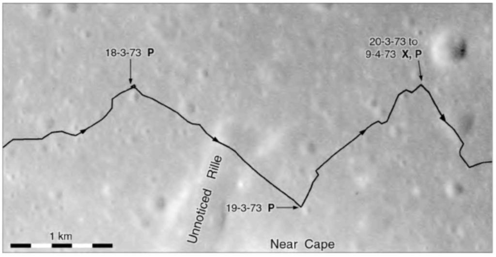
3 :UP/3-PAGINATION/IAW-PROOFS/3B2/978«52181«5(M.3D [7428] :28PM Chronological sequence of missions and events 353 Figure 312 Apollo 17 EVA 1. of craters, mountains and valleys over four lunar days and 37 km of travel. The rover paused around each lunar noon when lack of shadows made driving difficult, allowing the solar panels to recharge its batteries. At night the rover closed its "lid" to conserve heat, and was warmed by a small radioactive source. Lunokhod 2 returned 86 panoramic images and over TV pictures. Soil mechanics observations, laser ranging measurements and magnetometer readings were conducted throughout the drive. Solar X-rays were detected, and the light levels of the daytime sky were monitored. The light levels were unexpectedly high, enough to be an impediment to lunar daytime astronomy, but whether this counter-intuitive result is a true observation or the result of an instrument problem is unclear. On 4 June controllers announced that the mission was finished, having failed in mid-may. Lunokhod 2 was left parked in a position which allowed its laser retroreflector to be used, and it is still functioning today. Lunokhod l's reflector apparently cannot be used (page 261), but many reports on these missions erroneously reverse these statements. Figures 329 to 331 are compiled from Apollo 15 panoramic camera frames 9294 and 9296 and a map drawn to record the route and experiment locations of this highly successful rover mission. The map has not been published independently, but the western section was reproduced by Vernov (1978, p. 428). That illustration and a reduced version of the full map were kindly provided by Jeanna Rodionova of Sternberg State Astronomical Institute, Moscow. The Apollo 15 images have been reprojected to fit the Soviet map as closely as possible. Dates along the route in these figures are taken from the source map, but they do not correspond in all details with other accounts. The black line shows the route of Lunokhod 2. Dates of specific stops and experiments are shown. An X-ray fluorescence spectrometer measured the regolith composition at locations marked X. P indicates the locations of panoramic photography, though all panoramas may not be shown. L indicates the locations of laser reflector experiments. The laser retroreflector was supplied by France. S marks places where the daytime sky brightness was measured.
4 :UP/3-PAGINATION/IAW-PROOFS/3B2/978«52181«5(M.3D [7428] :29PM Chronological sequence of missions and events 355 After landing, the rover was driven eastwards 30 m and allowed to recharge its batteries (Figure 332). It then drove around the landing stage to photograph it, and then set off towards the southeast. It parked for the first lunar night on 19 January on the rocky rim of a small crater after having driven a total of 1260 m. Pictures were returned on 20 and 21 January and the Sun set on 23 January. Driving resumed on 10 February. From 12 to 16 February the rover parked near a large fresh boulder as the high Sun made visibility difficult. The rover then drove rapidly south to the nearby hills where it took new panoramic images and performed experiments. It headed northeast from the hills, back into the plains, on 19 February, and parked on 20 February for the second lunar night after having driven 9086 m during the previous lunar day. Lunokhod 2 resumed work on 12 March. It drove about 1 km north, and stopped to take images and soil composition data. Then, as a test of navigation and driving ability, the rover was driven rapidly southwards along its tracks for about 2 km, stopping late on 13 March at the foot of the hills. On 14 March it was driven northwards again along its tracks. This repeated traverse was also used to gather magnetometer data across the mare/highland boundary. Then the long drive to the east began, as documented in Figure 330. The Lunokhod controllers now set their sights on the mountains and the long fracture in the mare surface to the east. As they drove, periodic stops were made to take panoramic images and soil measurements. Soil mechanics observations and magnetometer readings were made throughout the route, the magnetometer showing varying field directions as Lunokhod passed craters. The longest daily drives were on 17 February (2230 m) and 18 February (3130 m). On 19 March Lunokhod 2 was driven through a shallow trough (Unnoticed Rille, or Fossa Inconspicua), which was apparently so subdued that it was barely noticed. On 20 March controllers stopped the rover for the night near a prominent 400 m diameter crater. This third day's drive had covered m, a remarkable achievement for remote rover operation. Two points are labelled (top section of Figure 330) but no point was labelled for 16 March on the map reproduced by Vernov (1978). This could possibly be a mistake in the original, but more likely it indicates that observations were made both early and late on 15 March and none on 16 March. The labelled
5 :UP/3-PAGINATION/IAW-PROOFS/3B2/978«52181«5(M.3D [7428] :30AM 356 International Atlas of Lunar Exploration points show places where observations were made, not overnight stops. The fourth day of activity for Lunokhod 2 began on 9 April. Every lunar day began with the rover's "lid" being opened to expose its lining of solar cells so the batteries could be recharged after the long lunar night. Lunokhod 2 was driven through a subdued crater and towards the edge of a prominent trough, Straight Rille or Fossa Recta (Figure 331). Magnetometer readings changed during the approach to the rim of the trough, and a roughly 500 m traverse away from and back to the rim was conducted on both sides of the trough to explore this further. By driving over the same route in opposite directions, local lunar magnetism could be distinguished from magnetic effects of the rover itself. The Lunokhodinduced magnetic effects were reversed by rotating the
6 :UP/3-PAGINATION/IAW-PROOFS/3B2/978«52181«5(M.3D [7428] :30AM Chronological sequence of missions and events 357 vehicle 180 degrees, while the lunar magnetism was unchanged. This also applied to the triple route mapped in Figure 329. The south end of the trough was rounded on 17 April. Extensive photography documented the rocky rims of the trough, which may have included rare bedrock exposures. Near the end of the lunar day, driving northeast away from the Sun with poor visibility, Lunokhod 2 was accidentally driven into a small crater (Chaikin 2004). As it maneuvered to climb out, the open lid protruding behind the body of the rover struck the crater wall and its solar cells were partly covered with soil. A drop in power was noted, though this was not itself a serious problem. Unfortunately, when the lid was closed to help keep the rover warm during the lunar night, the soil was dumped on thermal radiators intended to cool the rover during the day. The fourth lunar day included 8600 m of driving. Lunokhod 2 was roused on 8 May and driven for two more days towards the hill called Far Cape, but it overheated and died a few days into the fifth lunar day. Before operations ceased it was oriented so its laser reflector could be used in future. It was still being used in Lunokhod 2 had improved visibility provided by a top-mounted navigation camera, and a higher frame rate than Lunokhod 1 (every 3 seconds versus 20 seconds). These improvements, and the growing experience of ground controllers, were largely responsible for its ability to drive long distances. A third Lunokhod was built, incorporating further improvements, but the program was cancelled before it could be launched. Figure 332 shows the surroundings of the Luna 21 landing site. The map is based on panoramic images and must be considered only a rough sketch. Rocks are schematic, located properly but not to scale. Panorama locations are indicated with a letter P. This site was on the western rim of a very shallow crater roughly 250 m in diameter, beyond which could be seen the highest portion of the rim of Le Monnier crater, 50 km to the northeast. Luna 21 landed late on 15 January, and Lunokhod 2 soon drove off its landing stage towards the east. It parked about 30 m from the lander to recharge its batteries, having driven through a subdued 25 m diameter crater. On 18 January Lunokhod 2 was driven to a point on the north rim of the 25 m crater where it photographed the landing stage and the hill Le Monnier Alpha in the distance to the southwest. Here it was turned in place to create a circular mark with its wheels, and then moved a few meters where it made a second circle. The resulting figure 8 marking was later described as a memorial to commemorate International Women's Day, 8 March, which was a holiday in the Soviet Union and is in Russia today. Controllers then drove Lunokhod 2 close to the lander to photograph it. The rover came closer than was considered safe, about 4 m from it, and was carefully steered around it. A final panorama (Figure 333) showed the lander and tracks against the nearby craters and a hilly horizon. The tracks of Lunokhod 2 are visible at left and a hill, part of the southern rim of Le Monnier crater, is at far right. Then Lunokhod 2 set off on its long drive south to the rim of Le Monnier. More panoramas from Lunokhod 2 are presented in Figure 334.
![:UP/3-PAGINATION/IAW-PROOFS/3B2/978«52181«5(M.3D 3 7 0 [7428] 19.8.20073:30PM 370 International Atlas of Lunar Exploration Figure 327 Luna 21 landing area.](/docs-images/89/99213836/images/7-0.jpg "The location of the Luna 21 landing site, and its relationship to the Apollo 17 and old Littrow landing sites (Figures 308, 160C), are shown in Figure 327A.")
7 :UP/3-PAGINATION/IAW-PROOFS/3B2/978«52181«5(M.3D [7428] :30PM 370 International Atlas of Lunar Exploration Figure 327 Luna 21 landing area. The location of the Luna 21 landing site, and its relationship to the Apollo 17 and old Littrow landing sites (Figures 308, 160C), are shown in Figure 327A. Luna 21 landed about 5 km north of the hills forming the southern rim of Le Monnier, an old crater partly flooded by lavas from Mare Serenitatis. The low southern rim of Le Monnier was just visible from the landing site. More prominent on the horizon were the high eastern rim of the crater near 27 N, 32 E, and the high peak Le Monnier Alpha to the west.
![:UP/3-PAGINATION/IAW-PROOFS/3B2/978«52181«5(M.3D 3 7 1 [7428] 19.8.20073:30PM Chronological sequence of missions and events 371 Figure 327B is a mosaic of Apollo 15 panoramic camera images showing the landing area.](/docs-images/89/99213836/images/8-0.jpg "The image is distorted by oblique viewing, which is only partly corrected for by reprojection. The outline of Figure 328A is shown.")
8 :UP/3-PAGINATION/IAW-PROOFS/3B2/978«52181«5(M.3D [7428] :30PM Chronological sequence of missions and events 371 Figure 327B is a mosaic of Apollo 15 panoramic camera images showing the landing area. The image is distorted by oblique viewing, which is only partly corrected for by reprojection. The outline of Figure 328A is shown. There are many features of geological interest in this region including a long north-trending straight rille, probably indicating a deep fracture, east of the landing site. The base map for Figure 327A is the same as for Figure 308. The mosaic in Figure 327B includes parts of frames AS15-P-9292, 9294, 9296 and 9298.
![:UP/3-PAGINATION/IAW-PROOFS/3B2/978«52181«5(M.3D 3 7 2 [7428] 19.8.20073:30PM 372 International Atlas of Lunar Exploration 26 3 00' N 25 40 N 25 20' N 30 00' E 30 30' E 31 00'E Figure 328 The Luna 21 landing site.](/docs-images/89/99213836/images/9-0.jpg "Figure 328A is taken from a map produced at MIIGAiK using Apollo 15 image data, reproduced courtesy of K. B. Shingareva.")
9 :UP/3-PAGINATION/IAW-PROOFS/3B2/978«52181«5(M.3D [7428] :30PM 372 International Atlas of Lunar Exploration ' N N 25 20' N 30 00' E 30 30' E 31 00'E Figure 328 The Luna 21 landing site. Figure 328A is taken from a map produced at MIIGAiK using Apollo 15 image data, reproduced courtesy of K. B. Shingareva. Lunokhod 2's route was not shown on the original map, but it was added by hand to this copy of the map in the collection of the US Geological Survey in Flagstaff. Base map: Topograficheskaya karta na raion deistviya Lunokhoda-2, VN-B-3-41-C, original scale 1:50 000, 1973.
![:UP/3-PAGINATION/IAW-PROOFS/3B2/978«52181«5(M.3D 3 7 3 [7428] 19.8.20073:30PM Chronological sequence of missions and events 373 Figure 328B is a detail of Figure 328A showing the Lunokhod 2 route.](/docs-images/89/99213836/images/10-0.jpg "Several features are given informal names.")
10 :UP/3-PAGINATION/IAW-PROOFS/3B2/978«52181«5(M.3D [7428] :30PM Chronological sequence of missions and events 373 Figure 328B is a detail of Figure 328A showing the Lunokhod 2 route. Several features are given informal names. Published sources include alternate translations of some names: Unnoticed Rille and Straight Rille were also called Fossa Inconspicua and Fossa Recta respectively, in latinized forms similar to official lunar names. Round Gulf was also translated as Circle Harbour. These were the only informal names given to features at any Soviet landing site.

11 :UP/3-PAGINATION/IAW-PROOFS/3B2/978«52181«5(M.3D [7428] :30PM 374 International Atlas of Lunar Exploration Figure 329 Western section of Lunokhod 2 route.

12 :UP/3-PAGINATION/IAW-PROOFS/3B2/978«52181«5(M.3D [7428] :30PM Chronological sequence of missions and events 375 Figure 330 Central sections of Lunokhod 2 route.

13 :UP/3-PAGINATION/IAW-PROOFS/3B2/978«52181«5(M.3D [7428] :30PM 376 International Atlas of Lunar Exploration Figure 331 Eastern section of Lunokhod 2 route.


14 :UP/3-PAGINATION/IAW-PROOFS/3B2/978«52181«5(M.3D [7428] :30PM Chronological sequence of missions and events 11 Figure 332 The Luna 21 landing site. Figure 333 Luna 21 lander viewed from the west on 18 January.
![:UP/3-PAGINATION/IAW-PROOFS/3B2/978«52181«5(M.3D 3 7 8 [7428] 19.8.20073:30PM 378 International Atlas of Lunar Exploration Figure 334 (both pages) Lunokhod 2 panoramas.](/docs-images/89/99213836/images/15-0.jpg "Figure 334A shows the International Women's Day memorial (dark figure eight shape at left), situated a few meters northeast of the Luna 17 lander. The image was taken on 18 January.")
15 :UP/3-PAGINATION/IAW-PROOFS/3B2/978«52181«5(M.3D [7428] :30PM 378 International Atlas of Lunar Exploration Figure 334 (both pages) Lunokhod 2 panoramas. Figure 334A shows the International Women's Day memorial (dark figure eight shape at left), situated a few meters northeast of the Luna 17 lander. The image was taken on 18 January. The bright hills at left above a darker horizon form the highest part of the eastern rim of Le Monnier crater, 50 km from the landing site. Figure 334B shows hills forming the southern rim of Le Monnier crater. This image was taken on 18 March. The highest hill at the centre of the image is Near Cape. Far Cape lies at far left, just above the horizontal rod. A low ridge on the near horizon just to the right of Far Cape is the rim of a subdued crater just south of the rover, shown on Figure 330. The image was reproduced from a very-low-quality original and has been extensively enhanced. Figure 334C is a view of the hills of Le Monnier Alpha where Le Monnier crater meets Mare Serenitatis. The image was taken near local noon on the second lunar day, about 15 February, looking west. Figure 334D illustrates the typical appearance of the floor of Le Monnier crater, showing a 10 m diameter crater beyond the vertical hanging device. This is a composite of two panoramic images.
![:UP/3-PAGINATION/IAW-PROOFS/3B2/978«52181«5(M.3D 3 7 9 [7428] 19.8.20073:30PM Chronological sequence of missions and events 379 Figure 334E looks west on 10 February.](/docs-images/89/99213836/images/16-0.jpg "The hills at left are the northern parts of Le Monnier Alpha. Figure 334F is a southward view on 10 February. Le Monnier Alpha is at far right and the Tangled Hills span the left half of the horizon.")
16 :UP/3-PAGINATION/IAW-PROOFS/3B2/978«52181«5(M.3D [7428] :30PM Chronological sequence of missions and events 379 Figure 334E looks west on 10 February. The hills at left are the northern parts of Le Monnier Alpha. Figure 334F is a southward view on 10 February. Le Monnier Alpha is at far right and the Tangled Hills span the left half of the horizon. Figure 334G (rectified to show a level horizon) shows Straight Rille with its extensive boulder field, and the hills between Near Cape and Far Cape at extreme right. The image was taken on 16 April. Figure 334H is a panorama made just after the magnetometer traverse on 19 April. Straight Rille is at left, with Near Cape beyond it. All images except D have been reprojected to make the horizons level. Lunokhod images are usually printed reversed right to left, but here they are correctly oriented. Original images courtesy Sternberg State Astronomical Institute and MIIGAiK (A to D) and USGS Flagstaff (E to H).
Soviet Lunokhod 1 and 2 missions and things around
 Soviet Lunokhod 1 and 2 missions and things around Alexander Basilevsky Vernadsky Institute of Geochemistry and Analytical Chemistry Russian Academy of Sciences, Moscow, Russia and Department of Geological
Light-Lift Rocket II
 Light-Lift Rocket I Light-Lift Rocket II Medium-Lift Rocket A 0 7 00 4 MASS 90 MASS MASS This rocket can lift a mission that has up to 4 mass units. This rocket can lift a mission that has up to 90 mass
Lunette: A Global Network of Small Lunar Landers
 Lunette: A Global Network of Small Lunar Landers Leon Alkalai and John O. Elliott Jet Propulsion Laboratory California Institute of Technology LEAG/ILEWG 2008 October 30, 2008 Baseline Mission Initial
 Mission to Mars: Project Based Learning Previous, Current, and Future Missions to Mars Dr. Anthony Petrosino, Department of Curriculum and Instruction, College of Education, University of Texas at Austin
Travel: Detailed Flight Plan
 DarkSide Logistics Lunar Spaceport Initiative Travel: Detailed Flight Plan The payload will be launched from Cape Canaveral Air Force Station Launch Complex 46 at 15:59:35 ET on January 25, 2010, using
Rediscovery of the Lunokhod 1 Reflector
 Rediscovery of the Lunokhod 1 Reflector What it means for Lunar Ranging Science Tom Murphy (PI) Eric L. Michelsen UCSD and the APOLLO Collaboration Background photo: Dan Long Introduction to APOLLO APOLLO
FEDERAL SPACE AGENCY OF RUSSIAN FEDERATION LAVOCHKIN ASSOCIATION PROGRAM OF THE MOON EXPLORATION BY AUTOMATIC SPACE COMPLEXES
 FEDERAL SPACE AGENCY OF RUSSIAN FEDERATION LAVOCHKIN ASSOCIATION PROGRAM OF THE MOON EXPLORATION BY AUTOMATIC SPACE COMPLEXES 2007 CONCEPT 1. The program foresees development of automatic space complexes
Brief overview of lunar surface environment Examples of rover types and designs Steering systems Static and dynamic stability
 Brief overview of lunar surface environment Examples of rover types and designs Steering systems Static and dynamic stability 2007 David L. Akin - All rights reserved http://spacecraft.ssl.umd.edu Lunar
WHAT WE WILL DISCUSS IN THIS VIDEO
 WHAT WE WILL DISCUSS IN THIS VIDEO What is Chandrayaan 2 all about? Why is it special? Have we entered the The Asian space race? Where do China, Japan and India stand? What is the importance of the moon?
Silicon-Germanium Integrated Electronics for Extreme Environments Applied to the Design of a Lunar Hopper
 Silicon-Germanium Integrated Electronics for Extreme Environments Applied to the Design of a Lunar Hopper Presentation to Leora Peltz (Boeing Phantom Works, Huntington Beach CA, USA) leora.peltz@boeing.com,
Landing Targets and Technical Subjects for SELENE-2
 Landing Targets and Technical Subjects for SELENE-2 Kohtaro Matsumoto, Tatsuaki Hashimoto, Takeshi Hoshino, Sachiko Wakabayashi, Takahide Mizuno, Shujiro Sawai, and Jun'ichiro Kawaguchi JAXA / JSPEC 2007.10.23
Good afternoon. We're going to be talking today about frontiers of imagination in space exploration
 Good afternoon. We're going to be talking today about frontiers of imagination in space exploration First, though, I want to introduce myself. My name is Loretta Hall, and I'm a space buff. I've been a
Lunar Architecture and LRO
 Lunar Architecture and LRO Lunar Exploration Background Since the initial Vision for Space Exploration, NASA has spent considerable time defining architectures to meet the goals Original ESAS study focused
Two Related Primary Challenges for Successful Renewed Lunar Exploration
 Two Related Primary Challenges for Successful Renewed Lunar Exploration October 10, 2017 Presented By Ron Creel Retired Apollo Lunar Roving Vehicle Team Member OUTLINE Challenge 1 Coping with Exposure
Name: Space Exploration PBL
 Name: Space Exploration PBL Students describe the history and future of space exploration, including the types of equipment and transportation needed for space travel. Students design a lunar buggy and
Curiosity lands on Mars
 Curiosity lands on Mars Early Monday morning (August 6, 2012), the Mars rover named Curiosity successfully landed on the surface of Mars. The rover launched on November 26 th, 2011 and traveled for 8 ½
INTERNATIONAL LUNAR NETWORK ANCHOR NODES AND ROBOTIC LUNAR LANDER PROJECT UPDATE
 INTERNATIONAL LUNAR NETWORK ANCHOR NODES AND ROBOTIC LUNAR LANDER PROJECT UPDATE NASA/ Barbara Cohen Julie Bassler Greg Chavers Monica Hammond Larry Hill Danny Harris Todd Holloway Brian Mulac JHU/APL
Determination of Monthly Means of Daily Solar Radiation and its Variability: A Summary (continued)
") Introduction Section 5.3 MONTHLY MEANS OF DAILY SOLAR RADIATION AND ITS VARIABILITY R.E. Schulze, M. Maharaj and R.D. Chapman The maps and statistics of solar radiation in this Section supersede the ones
Introduction Section 5.3 MONTHLY MEANS OF DAILY SOLAR RADIATION AND ITS VARIABILITY R.E. Schulze, M. Maharaj and R.D. Chapman The maps and statistics of solar radiation in this Section supersede the ones
Initial Concept Review Team Alpha ALUM Rover (Astronaut Lunar Utility Mobile Rover) Friday, October 30, GMT
 Friday, October 30, GMT") Initial Concept Review Team Alpha ALUM Rover (Astronaut Lunar Utility Mobile Rover) Friday, October 30, 2009 1830-2030 GMT Rover Requirements/Capabilities Performance Requirements Keep up with an astronaut
Initial Concept Review Team Alpha ALUM Rover (Astronaut Lunar Utility Mobile Rover) Friday, October 30, 2009 1830-2030 GMT Rover Requirements/Capabilities Performance Requirements Keep up with an astronaut
Canadian Lunar & Planetary Rover. Development
 Canadian Lunar & Planetary Rover Guy who likes rovers Development Lunar Exploration Analysis Group Meeting October 21, 2015 Peter Visscher, P.Eng. Argo/Ontario Drive & Gear Ltd. Perry Edmundson, P.Eng.
NEXT Exploration Science and Technology Mission. Relevance for Lunar Exploration
 NEXT Exploration Science and Technology Mission Relevance for Lunar Exploration Alain Pradier & the NEXT mission team ILEWG Meeting, 23 rd September 2007, Sorrento AURORA PROGRAMME Ministerial Council
Exploration Architecture Update
 Exploration Architecture Update Doug Cooke Deputy Associate Administrator Exploration Systems Mission Directorate John Connolly Vehicle Engineering and Integration Lunar Lander Project Office March 14,
Building an Economical and Sustainable Lunar Infrastructure To Enable Lunar Science and Space Commerce
 Building an Economical and Sustainable Lunar Infrastructure To Enable Lunar Science and Space Commerce Dr. Allison Zuniga, Mark Turner and Dr. Dan Rasky NASA Ames Research Center Space Portal Office Mike
Challenges of Designing the MarsNEXT Network
 Challenges of Designing the MarsNEXT Network IPPW-6, Atlanta, June 26 th, 2008 Kelly Geelen kelly.geelen@astrium.eads.net Outline Background Mission Synopsis Science Objectives and Payload Suite Entry,
On Orbit Refueling: Supporting a Robust Cislunar Space Economy
 On Orbit Refueling: Supporting a Robust Cislunar Space Economy Courtesy of NASA 3 April 2017 Copyright 2014 United Launch Alliance, LLC. All Rights Reserved. Atlas V Launch History ULA s Vision: Unleashing
Montour No. 10 (Bob Ciminel 2012)
") Montour No. 10 (Bob Ciminel 2012) As we continue eastward from Montour No. 4, we reach Library Junction at Mile post 35.08. The west leg of the wye takes us onto the Library Branch. After crossing Library
Montour No. 10 (Bob Ciminel 2012) As we continue eastward from Montour No. 4, we reach Library Junction at Mile post 35.08. The west leg of the wye takes us onto the Library Branch. After crossing Library
Planetary Surface Transportation and Site Development
 Planetary Surface Transportation and Site Development Larry Bell * Sasakawa International Center for Space Architecture (SICSA), Houston, TX 77204-4000 This paper presents considerations and concepts for
Lunar Driving Simulator History
 1 of 20 Lunar Driving Simulator History Early NASA MSFC/Northrop MOLAB Concept. This vehicle concept evolved from the study contract NAS8-11096 in support of the early Apollo Logistic Support System studies
Edible Rovers Activity High School Edible Rover Worksheet Geometry Answers
 Edible Rovers Activity High School Edible Rover Worksheet Geometry Answers Instructions You have just been notified that NASA is planning to launch another Mars Rover Mission and you are going to design
LUNAR INDUSTRIAL RESEARCH BASE. Yuzhnoye SDO proprietary
 LUNAR INDUSTRIAL RESEARCH BASE DESCRIPTION Lunar Industrial Research Base is one of global, expensive, scientific and labor intensive projects which is to be implemented by the humanity to meet the needs
Photo: DA518, 05/05/2009 Photo: DA468, 05/05/2009 Photo: DA462, 05/05/2009
 GSA DATA REPOSITORY 2013156 Item DR1 Photographs of the Southern Sector of Stromboli s Crater Terrace showing changes in observable bomb distribution in this sector between each of the six major explosions
Mars Surface Mobility Proposal
 Mars Surface Mobility Proposal Jeremy Chavez Ryan Green William Mullins Rachel Rodriguez ME 4370 Design I October 29, 2001 Background and Problem Statement In the 1960s, the United States was consumed
Solar Power. Demonstration Site. Annual Performance Report 2017
 Solar Power Demonstration Site Annual Performance Report 217 Version :1. July 12, 218 Solar Power Demonstration Site 217 Performance Report Introduction INTRODUCTION The Solar Power Demonstration Site
PROPOSED HELICOPTER LANDING PAD 85 MILL ROAD LARA
 PROPOSED HELICOPTER LANDING PAD 85 MILL ROAD LARA Assessment of Helicopter Noise A report Prepared on behalf of: JamCo Constructions Pty Ltd PO Box 631 Yarraville Victoria 3013 Ref: 11573-3jg March 2015
ASTRIUM. Lunar Lander Concept for LIFE. Hansjürgen Günther TOB 11. Bremen, 23/
 Lunar Lander Concept for LIFE Hansjürgen Günther TOB 11 Bremen, 23/24.11.2006 This document is the property of EADS SPACE. It shall not be communicated to third parties without prior written agreement.its
Supplemental Historical Background for Lake Sangraco and the Kershaw Ditch, Adams County, Colorado
 Supplemental Historical Background for Lake Sangraco and the Kershaw Ditch, Prepared for: Regional Transportation District 1560 Broadway, Suite 700 Denver, Colorado 80202 303-299-2426 Prepared by: Thomas
Transportation Copyright Council for Economic Education
 Transportation 1929-1959 1929-1939 The Great Depression Image Source: Library of Congress Image Source: U.S. Dept. of Energy Image Source: Library of Congress 1939-1945 World War II 1943 Programmable Computer
Maximum ABS Braking Tests On A Freshly Re-Graded Gravel Shoulder
 Maximum ABS Braking Tests On A Freshly Re-Graded Gravel Shoulder Posting Date: 27-Nov 2013 In January, 2013 an article was uploaded to the Gorski Consulting Articles webpage entitled "Lessons Learned From
Abstract #1756. English. French. Author(s) and Co Author(s) ispace & Team Hakuto s 2017 Lunar Mission
 and Co Author(s) ispace & Team Hakuto s 2017 Lunar Mission") 4/25/2017 CIM TPMS Abstract #1756 English ispace & Team Hakuto s 2017 Lunar Mission This presentation will introduce ispace, a lunar exploration company headquartered in Tokyo, Japan, and Team Hakuto,
4/25/2017 CIM TPMS Abstract #1756 English ispace & Team Hakuto s 2017 Lunar Mission This presentation will introduce ispace, a lunar exploration company headquartered in Tokyo, Japan, and Team Hakuto,
Westland No. 1 Mine (Bob Ciminel 2012)
") Westland No. 1 Mine (Bob Ciminel 2012) Westland Mine No. 1 was owned by the Pittsburgh Coal Company and located at the eastern (timetable) end of the Montour Railroad s Midland Spur/Westland Branch, just
Westland No. 1 Mine (Bob Ciminel 2012) Westland Mine No. 1 was owned by the Pittsburgh Coal Company and located at the eastern (timetable) end of the Montour Railroad s Midland Spur/Westland Branch, just
Station for Exploratory Analysis and Research Center for Humanity (SEARCH)
") Station for Exploratory Analysis and Research Center for Humanity (SEARCH) Authors: Jasmine Wong, Matthew Decker, Joseph Lewis, Megerditch Arabian, and Dr. Peter Bishay California State University, Northridge
Station for Exploratory Analysis and Research Center for Humanity (SEARCH) Authors: Jasmine Wong, Matthew Decker, Joseph Lewis, Megerditch Arabian, and Dr. Peter Bishay California State University, Northridge
PROPOSED TRAFFIC RESOLUTION
 Reference Number: TR 52-18 Location: Frobisher Street and Severn Street - Island Bay Proposal: Information: To provide two new bus stop locations on Frobisher Street, and change the time restriction on
Another way to get an elevation chart ( ):
:") Dave Roper s Experience Driving the Nissan LEAF http://www.roperld.com/science/nissanleaf.htm http://www.roperld.com/science/leafroper.pdf http://www.roperld.com/science/nissanleaftrips_bburgtoroa.pdf
Dave Roper s Experience Driving the Nissan LEAF http://www.roperld.com/science/nissanleaf.htm http://www.roperld.com/science/leafroper.pdf http://www.roperld.com/science/nissanleaftrips_bburgtoroa.pdf
EIS MTM/TTM THERMAL BALANCE TEST SPECIFICATION, PROCEDURES AND PREDICTIONS
 SOLAR-B Instrument EIS MTM/TTM THERMAL BALANCE TEST SPECIFICATION, PROCEDURES AND PREDICTIONS Document No. BU/SLB-EIS/TN/020.03 Compiled by H. Mapson-Menard and C. V. Goodall The University of Birmingham
Resource Prospector Traverse Planning
 Resource Prospector Traverse Planning Jennifer Heldmann (NASA Ames / NASA Headquarters) Anthony Colaprete (NASA Ames Research Center) Richard Elphic (NASA Ames Research Center) Ben Bussey (NASA Headquarters)
First published June 2007 Copyright China Trend Building Press Limited
 First published June 2007 Copyright China Trend Building Press Limited trend@building.com.hk In order to construct the foundations, piers and portal frames for the viaduct, a 1.8 km-long temporary access
CONSUMERS SERVICE COMPANY PHOTOGRAPHS, CA. 1915
 Collection # P 0274 CONSUMERS SERVICE COMPANY PHOTOGRAPHS, CA. 1915 Collection Information Historical Sketch Scope and Content Note Contents Cataloging Information Processed by Emily Scott 27 February
The European Lunar Lander Mission
 The European Lunar Lander Mission Alain Pradier ASTRA Noordwijk, 12 th April 2011 European Space Agency Objectives Programme Objective PREPARATION FOR FUTURE HUMAN EXPLORATION Lunar Lander Mission Objective
Solar Emergency Preparedness Signs
 Solar Powered Signage Powered by Powerline Technology Solar Emergency Preparedness Signs Electrical Grid Failure Caused By: Blackouts Hurricanes Ice Storms Coastal Flooding Homeland Security-Related Incidents
1. Passive Solar Design
 During the conceptual design phase of urban areas, the designer deals with different geometrical characteristics of the project Design Tools for Solar and Daylight Access in Urban Design Climate and Energy
Pre-Launch Procedures
 Pre-Launch Procedures Integration and test phase This phase of operations takes place about 3 months before launch, at the TsSKB-Progress factory in Samara, where Foton and its launch vehicle are built.
ENERGIA 1. IDENTIFICATION. 1.1 Name. 1.2 Classification Family : K Series : K-1/SL-17 Version : 4 strap-ons
 1. IDENTIFICATION 1.1 Name 1.2 Classification Family : K Series : K-1/SL-17 Version : 4 strap-ons Category : SPACE LAUNCH VEHICLE Class : Heavy Lift Vehicles (HLV) Type : Expendable Launch Vehicle (ELV)
ASHPRINGTON ROAD Part 1
 MODEL RAILWAYS ON-LINE ASHPRINGTON ROAD Part 1 By Graham Plowman Photographed by Paul Plowman 2 MODEL RAILWAYS ON-LINE ASHPRINGTON ROAD A 00 layout based on the Western Region Main Line between Exeter
Moon Exploration Lunar Polar Sample Return ESA Thematic information day BELSPO, 3 July 2012
 Moon Exploration Lunar Polar Sample Return ESA Thematic information day BELSPO, 3 July 2012 Human Spaceflight and Operations (HSO)) 1 Introduction Moon Exploration has a very high priority in Roscosmos
Cooperative EVA/Telerobotic Surface Operations in Support of Exploration Science
 Cooperative EVA/Telerobotic Surface Operations in Support of Exploration Science David L. Akin http://www.ssl.umd.edu Planetary Surface Robotics EVA support and autonomous operations at all physical scales
Project Title: Lowertown Ballpark (CHS Field) Solar Arrays Contract Number: EP4-34 Milestone Number: 1 Report Date: June 21, 2016
 Solar Arrays Contract Number: EP4-34 Milestone Number: 1 Report Date: June 21, 2016") DEPARTMENT OF PARKS AND RECREATION DESIGN AND CONSTRUCTION CITY OF SAINT PAUL Mayor Christopher B. Coleman 400 City Hall Annex 25 West 4 th Street Saint Paul, Minnesota 55102 www.stpaul.gov/parks Telephone:
DEPARTMENT OF PARKS AND RECREATION DESIGN AND CONSTRUCTION CITY OF SAINT PAUL Mayor Christopher B. Coleman 400 City Hall Annex 25 West 4 th Street Saint Paul, Minnesota 55102 www.stpaul.gov/parks Telephone:
REPORT A-008/2008 DATA SUMMARY
 REPORT A-008/2008 DATA SUMMARY LOCATION Date and time Wednesday, 5 March 2008; 08:25 local time 1 Site Yaiza (Island of Lanzarote) AIRCRAFT Registration Type and model EC-FJV AEROSPATIALE AS-350B2 Operator
AP Physics B: Ch 20 Magnetism and Ch 21 EM Induction
 Name: Period: Date: AP Physics B: Ch 20 Magnetism and Ch 21 EM Induction MULTIPLE CHOICE. Choose the one alternative that best completes the statement or answers the question. 1) If the north poles of
Abstract #1754. English. French. Author(s) and Co Author(s) Resources in the cislunar marketplace. To follow. No abstract title in French
 and Co Author(s) Resources in the cislunar marketplace. To follow. No abstract title in French") 4/26/2017 CIM TPMS Abstract #1754 English Resources in the cislunar marketplace To follow French No abstract title in French No French resume Author(s) and Co Author(s) Mr. GEorge Sowers (UnknownTitle)
4/26/2017 CIM TPMS Abstract #1754 English Resources in the cislunar marketplace To follow French No abstract title in French No French resume Author(s) and Co Author(s) Mr. GEorge Sowers (UnknownTitle)
LUNAR DAYLIGHT EXPLORATION Cost Constrained Human and Robotic Exploration Brand Norman Griffin 1 A.M., ASCE
 LUNAR DAYLIGHT EXPLORATION Cost Constrained Human and Robotic Exploration Brand Norman Griffin 1 A.M., ASCE ABSTRACT With 1 rover, 2 astronauts and 3 days, the Apollo 17 Mission covered over 30 km, setup
Since the late 1990s, Moscow has conducted a slow but systematic restoration of its fleet of long-range Bears and Blackjacks.
 New Dawn for Russia Since the late 1990s, Moscow has conducted a slow but systematic restoration of its fleet of long-range Bears and Blackjacks. Photography by Aleksey Mikheyev Above, the crew of a Tu-160
Adrestia. A mission for humanity, designed in Delft. Challenge the future
 Adrestia A mission for humanity, designed in Delft 1 Adrestia Vision Statement: To inspire humanity by taking the next step towards setting a footprint on Mars Mission Statement Our goal is to design an
2019 Western North Carolina Weather Calendar. Department of Atmospheric Sciences The University of North Carolina at Asheville
 209 Western North Carolina Weather Calendar Department of Atmospheric Sciences The University of North Carolina at Asheville www.atms.unca.edu 209 Western North Carolina Weather Calendar Climatological
Pantheon Mission Profiles
 Pantheon Mission Profiles BACKGROUND Pantheon is the largest planet in the KRML Cluster. It has an atmosphere that can support human and plant life. Pantheon has drinkable water, but it currently lacks
RIMRES: A project summary
 RIMRES: A project summary at ICRA 2013 -- Planetary Rovers Workshop presented by Thomas M Roehr, thomas.roehr@dfki.de DFKI Robotics Innovation Center Bremen Robert-Hooke Straße 5 28359 Bremen 1 Acknowledgements
THE MARS EXPLORATION ROVERS: HITTING THE ROAD ON MARS. Nagin Cox
 THE MARS EXPLORATION ROVERS: HITTING THE ROAD ON MARS Nagin Cox Jet Propulsion Laboratory National Air & Space Administration/California Institute of Technology Email: nagin@jpl.nasa.gov Abstract: Since
OMOTENASHI. (Outstanding MOon exploration TEchnologies demonstrated by NAno Semi-Hard Impactor)
") SLS EM-1 secondary payload OMOTENASHI (Outstanding MOon exploration TEchnologies demonstrated by NAno Semi-Hard Impactor) The smallest moon lander launched by the most powerful rocket in the world * Omotenashi
SLS EM-1 secondary payload OMOTENASHI (Outstanding MOon exploration TEchnologies demonstrated by NAno Semi-Hard Impactor) The smallest moon lander launched by the most powerful rocket in the world * Omotenashi
1. What type of material can be induced to become a temporary magnet? A) diamagnetic B) ferromagnetic C) monomagnetic D) paramagnetic
 diamagnetic B) ferromagnetic C) monomagnetic D) paramagnetic") Assignment 1 Magnetism and Electromagnetism Name: Multiple Choice Identify the letter of the choice that best completes the statement or answers the question. Show appropriate workings. 1. What type of
Assignment 1 Magnetism and Electromagnetism Name: Multiple Choice Identify the letter of the choice that best completes the statement or answers the question. Show appropriate workings. 1. What type of
Industrial-and-Research Lunar Base
 Industrial-and-Research Lunar Base STRATEGY OF LUNAR BASE CREATION Phase 1 Preparatory: creation of international cooperation, investigation of the Moon by unmanned spacecraft, creation of space transport
Monitoring Bank Erosion On the Missouri River, Lower Brule Reservation
 Monitoring Bank Erosion On the Missouri River, Lower Brule Reservation A cooperative study between the Lower Brule Sioux Tribe s Environmental Protection Office and the U.S. Geological Survey, with assistance
Cygnus Payload Accommodations: Supporting ISS Utilization
 The Space Congress Proceedings 2018 (45th) The Next Great Steps Feb 27th, 1:30 PM Cygnus Payload Accommodations: Supporting ISS Utilization Frank DeMauro Vice President and General Manager, Advanced Programs
THUNDERBIRD Solar Electric Fence Energisers. S20 / S20B / S40 / S40B / S79 / S150
 THUNDERBIRD Solar Electric Fence Energisers. S20 / S20B / S40 / S40B / S79 / S150 Thunderbirds range of small/medium solar energiser come in a range of packages as follows - S20-2 km system 12 volt battery
Solar Electric Systems. By Andy Karpinski
 Solar Electric Systems By Andy Karpinski Solar Electric Systems These are systems for generating electricity by sunlight. This talk will focus on residential (as opposed to commercial or industrial) applications.
Suitability of reusability for a Lunar re-supply system
 www.dlr.de Chart 1 Suitability of reusability for a Lunar re-supply system Etienne Dumont Space Launcher Systems Analysis (SART) Institut of Space Systems, Bremen, Germany Etienne.dumont@dlr.de IAC 2016
Next Steps in Human Exploration: Cislunar Systems and Architectures
 Next Steps in Human Exploration: Cislunar Systems and Architectures Matthew Duggan FISO Telecon August 9, 2017 2017 The Boeing Company Copyright 2010 Boeing. All rights reserved. Boeing Proprietary Distribution
Creating a Lean and Productive Processing Facility
 Creating a Lean and Productive Processing Facility Amsterdam 31st May 2013 Nick Tandy EBA Flying Squad Operational Improvement Lead, Filton, until May 2011 Sarah Raymond Head of Operations Filton, NHS
Nanometrics Solar Power System
 Nanometrics Solar Power System Installation Guide Nanometrics Inc. Kanata, Ontario Canada 2003 Nanometrics Inc. All Rights Reserved. Installation Guide The information in this document has been carefully
WAGONS OF THE A & G DRAMWAY
 WAGONS OF THE A & G DRAMWAY Keith Thomas The most reliable source of information of the types of wagon used. one the Avon and Gloucestershire Dramroad is John Cornwall's Photograph of the Bath Road crossing
Spacecraft Power Systems
 Spacecraft Power Systems The Generation and Storage of Electrical Power D. B. Kanipe Aero 401 February 9, 2016 Power Systems Batteries Solar Cells + Batteries Fuel Cells RTG Nuclear Reactors? Functions
Greater Albuquerque Area Monthly Housing Trends vs. 2011
 Greater Albuquerque Area Monthly Housing Trends - 2010 vs. 2011 Class R1 (Existing Single-Family Detached) and Class R2 (Existing Condo/Townhome Attached) homes Data on this page was obtained from the
WOLVERINE TO BHP JANSEN NEW TRANSMISSION LINE PROJECT FALL 2017
 WOLVERINE TO BHP JANSEN NEW TRANSMISSION LINE PROJECT FALL 2017 TODAY WE LL TALK ABOUT Our challenges and how we re meeting them Why we re building this project Our planning process and considerations
2 EXISTING ROUTE STRUCTURE AND SERVICE LEVELS
 2 EXISTING ROUTE STRUCTURE AND SERVICE LEVELS In the Study Area, as in most of the Metro Transit network, there are two distinct route structures. The base service structure operates all day and the peak
6. The Launch Vehicle
 6. The Launch Vehicle With the retirement of the Saturn launch vehicle system following the Apollo-Soyuz mission in summer 1975, the Titan III E Centaur is the United State s most powerful launch vehicle
European Lunar Lander: System Engineering Approach
 human spaceflight & operations European Lunar Lander: System Engineering Approach SECESA, 17 Oct. 2012 ESA Lunar Lander Office European Lunar Lander Mission Objectives: Preparing for Future Exploration
Lunar Science and Infrastructure with the Future Lunar Lander
 ICEUM9 Sorrento Lunar Science and Infrastructure with the Future Lunar Lander Session 9: Next steps for Robotic Landers, Rovers and Outposts ICEUM9 Sorrento, Oct. 26, 2007 Hansjürgen Günther 26/10/2007
Massachusetts Space Grant Consortium
 Massachusetts Space Grant Consortium Distinguished Lecturer Series NASA Administrator Dr. Michael Griffin NASA s Exploration Architecture March 8, 2006 Why We Explore Human curiosity Stimulates our imagination
Cliffbot CRV tests. Mars2013 simulation. Main results
 Cliffbot CRV tests Mars2013 simulation Main results Summary 1 Objectives 2 Tests general information 3 Results 4 Conclusions The CRV and an operator in the Aouda spacesuit 1 Objectives The Cliff Reconnaissance
Installation and User Manual. with RAIN SENSOR.
 with RAIN SENSOR www.solarsmartopener.com Revision..0 TABLE OF CONTENTS Features In The Box Further Items Required Basic Operation Solar Panel and Operator Installation Operator Installation Solar Panel
THE HISTORY OF MARS EXPLORATION
 THE HISTORY OF MARS EXPLORATION Philippe Masson 1st Mars Express Science Conference (ESTEC, February 21-25, 2005) Mars Observers: The European Pioneers Nicolaus Copernicus: described the motion of the
Title Goes Here and Can Run Solar Photovoltaic up to 3 lines as shown here Systems as you see
 Title Goes Here and Can Run Solar Photovoltaic up to 3 lines as shown here Systems as you see CHAPTER 2 Outline the components of a solar photovoltaic system Describe the operation of a solar photovoltaic
Cassini-Huygens Power Conversion Technology
 Cassini-Huygens General Purpose Heat Source Radioisotope Thermoelectric Generator (GPHS-RTG) The GPHS-RTG is the first standardized RTG design using GPHS modules to encase the fuel. In today s mission,
Greater Albuquerque Area Monthly Housing Trends vs. 2016
 Month Greater Albuquerque Area Monthly Housing Trends - 2015 vs. 2016 Class R1 (Existing Single-Family Detached) and Class R2 (Existing Condo/Townhome Attached) homes Data on this page was obtained from
CLIMATOLOGICAL SUMMARY
 DEPARTMENT OF REGISTRATION AND EDUCATION CTATP OF ILLINOIS ILLINOIS STATE WATER SURVEY DIVISION URBANA, ILLINOIS ISWS MP-19 Archive ISWS Illinois State Water Survey )CAL CLIMATOLOGICAL DATA MP-19 LOCAL
MARINE STEERING COMPASS
 MARINE STEERING COMPASS INTRODUCTION PRE-TEST OF INSTRUMENT INSTALLATION OF SENSOR SENSOR REMOVAL INSTALLING THE DISPLAY NORMAL OPERATION CHANGING THE BACKLIGHT SETTING CHANGING THE DAMPING ASSISTED STEERI
A LEO Propellant Depot System Concept for Outgoing Exploration
 A LEO Propellant Depot System Concept for Outgoing Exploration Dallas Bienhoff The Boeing Company 703-414-6139 NSS ISDC Dallas, Texas May 25-28, 2007 First, There was the Vision... Page 1 Then, the ESAS
An Overview of CSA s s Space Robotics Activities
 An Overview of CSA s s Space Robotics Activities Erick Dupuis, Mo Farhat ASTRA 2011 ESTEC, Noordwijk, The Netherlands Introduction Key Priority Area for CSA Recent Reorganisation Strategy Guided by Global
AMSAT-NA FOX Satellite Program
 AMSAT-NA FOX Satellite Program Review, Status, and Future JERRY BUXTON, NØJY, AUTHOR AMSAT VP-ENGINEERING Review FOX-1 - WHY IT IS, WHAT IT IS Fox Development Strategy Take advantage of large and growing
Greater Albuquerque Area Monthly Housing Trends vs. 2017
 Month Greater Albuquerque Association of REALTORS Greater Albuquerque Area Monthly Housing Trends - 2016 vs. 2017 Class R1 (Existing Single-Family Detached) and Class R2 (Existing Condo/Townhome Attached)
UNDERWATER SOLUTIONS WORLDWIDE
 UNDERWATER SOLUTIONS WORLDWIDE Payload Autonomy on the Phoenix International Artemis AUV MOOS-DAWG 2015 July 22-23 Peter McKibbin IRAD/Special Projects Manager pmckibbin@phnx-international.com Brief Company
Unit 8 ~ Learning Guide Name:
 Unit 8 ~ Learning Guide Name: Instructions: Using a pencil, complete the following notes as you work through the related lessons. Show ALL work as is explained in the lessons. You are required to have