2011 Dashboard. Report. White Paper
|
|
|
- Randall Cummings
- 5 years ago
- Views:
Transcription


1 2011 Dashboard Report White Paper
2 Purpose and Introduction This white paper was developed to accompany the quarterly and annual Kansas Strategic Highway Safety Plan (SHSP) Dashboard Reports, produced by the Highway Safety Unit at the Kansas Department of Transportation (KDOT). This document is intended to provide guidance and clarification on how to read and interpret the information presented in the Dashboard Reports. Contents The report outlines the latest motor vehicle fatality numbers for the state of Kansas. The quarterly Dashboard Report contains year-to-date preliminary (not officially closed out) fatality data for the following quarters: Quarter One: January 1st through March 31st Quarter Two: January 1st through June 30th Quarter Three: January 1st through September 30th Quarter Four (Annual Report): January 1st through December 31st The annual Dashboard Report contains annual preliminary fatality data from January 1st through December 31st. The Report can also be generated ad-hoc as requested by the Executive Safety Council (ESC). The Report presents either quarterly or annual fatality counts compared to the previous year. These figures are then further broken down statewide and at the district level by the emphasis areas outlined in the SHSP or as requested by the ESC. Current Emphasis Area Analysis Categories Roadway Attributes Local Roadways State Highways Urban Rural Intersections Horizontal Curves Driver Attributes Seatbelt Usage Teen Drivers Older Drivers Impaired Drivers Crash Types Roadway Departure Vehicle Attributes Large Commercial Vehicles Motorcycles and Mopeds Other Fatality Data District Fatality Data Strategic Highway Safety Plan July 1,
3 Important Notes Regarding the Data *All fatality data is subject to change data provided in this report is only current to the date of which the report is created. The statewide total number of fatalities will not always match the number of fatalities analyzed. The statewide total number of fatalities is generated by KDOT's Fatality Analysis Reporting System (FARS) analyst who has access to death certificates and EMS reports, thus KDOT can confirm a motor vehicle fatality even if an official Motor Vehicle Accident Report has not yet been submitted to KDOT. KDOT does not always receive every fatal Motor Vehicle Accident Report by the time the Dashboard Report is generated. This if often due to some crashes still being investigated by law enforcement or law enforcement agencies may not have submitted the report yet. Without these crash reports, KDOT cannot confirm details regarding the fatality such as the crash location, crash type, impairment and other important crash details. For this reason, KDOT can only analyze fatalities in which we have received a fatal crash report. Fatalities involving an impaired driver are subject to change. Impaired driving, for the purpose of this report and the Kansas Strategic Highway Safety Plan, is defined as at least one driver reported as under the influence of alcohols or drugs. Alcohol and drug involvement can either be recorded on the Motor Vehicle Accident Report at the time of the crash by the reporting law enforcement officer or a Report can be amended or updated to reflect toxicology reports. Toxicology reports can take time, and for this reason, some fatal crash reports may still be amended to reflect pending results. July 1, Strategic Highway Safety Plan

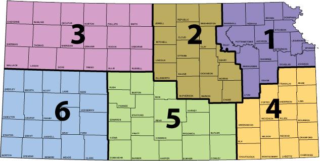
4 What are Districts? KDOT is organized into six districts: District One Northeast Kansas; District Two Northcentral Kansas; District Three Northwest Kansas; District Four Southeast Kansas; District Five Southcentral Kansas; District Six Southwest Kansas. These districts provide a clear regional organization that includes all 105 counties in Kansas. See which counties fall into which districts below. DISTRICT ONE DISTRICT TWO DISTRICT THREE DISTRICT FOUR DISTRICT FIVE DISTRICT SIX Atchison Brown Doniphan Douglas Jackson Jefferson Johnson Leavenworth Lyon Marshall Nemaha Osage Pottawatomie Riley Shawnee Wabaunsee Wyandotte Chase Clay Cloud Dickinson Ellsworth Geary Jewell Lincoln Marion McPherson Mitchell Morris Ottawa Republic Saline Washington Cheyenne Decatur Ellis Gove Graham Logan Norton Osborne Phillips Rawlins Rooks Russel Sheridan Sherman Smith Thomas Trego Wallace Allen Anderson Bourbon Chautauqua Cherokee Coffey Crawford Elk Franklin Greenwood Labette Linn Miami Montgomery Neosho Wilson Woodson Barber Barton Butler Comanche Cowley Edwards Harper Harvey Kingman Kiowa Pawnee Pratt Reno Rice Rush Sedgwick Stafford Sumner Clark Finney Ford Grant Gray Greely Hamilton Haskell Hodgeman Kearny Lane Meade Morton Ness Scott Seward Stanton Stevens Wichita Why examine fatalities by district as opposed to metropolitan planning organization (MPO) areas or by individual counties? Analysis can certainly be done at both the MPO area and county level. Examining crashes only at an MPO level, however, can exclude many rural counties which are not included in an MPO. In addition, with 105 counties in Kansas, county level analysis might be too specific and not give an adequate regional perspective. For the purposes and intended length of this report, district division allows for a regional perspective without producing 105 individual analyses. Strategic Highway Safety Plan July 1,
5 Definitions, Acronyms and Query Details Closed Out Crash data which is finalized by KDOT's Geometric and Accident Data Unit. Executive Safety Council (ESC) A newly constituted Kansas Executive Safety Council, or ESC, first met on May 14, It is comprised of administrators, engineers, planners, medical care providers, trainers/educators and law enforcement personnel. The council champions transportation safety on all public roads in Kansas by developing an SHSP that will drive the formulation and implementation of safetyrelated programs. Mike Floberg, of KDOT, and Jim Hanni, of the Automobile Association of America, are co-chairs. A complete list of agencies and representatives can be found in the Partners, Roles and Processes Chapter of the 2011 Kansas Strategic Highway Safety Plan, Fatality A fatality or fatal injury is any injury that results in death to a person within 30 days of a motor vehicle crash on any public road. Fatality Analysis Reporting System (FARS) The Fatality Analysis Reporting System (FARS) contains data derived from a census of fatal traffic crashes within the 50 States, the District of Columbia, and Puerto Rico. To be included in FARS, a crash must involve a motor vehicle traveling on a trafficway customarily open to the public and result in the death of a person (occupant of a vehicle or a non-motorist) within 30 days of the crash. FARS was conceived, designed, and developed by the National Center for Statistics and Analysis (NCSA) of the National Highway Traffic Safety Administration (NHTSA) in 1975 to provide an overall measure of highway safety, to help identify traffic safety problems, to suggest solutions, and to help provide an objective basis to evaluate the effectiveness of motor vehicle safety standards and highway safety programs. To read more about FARS, go to: To view FARS data, go to: Highway Safety Unit The Highway Safety Unit is a unit within the Bureau of Traffic Safety and Technology at KDOT. The Highway Safety Unit's primary function is to develop, maintain, and implement a statewide Strategic Highway Safety Plan (SHSP) for the state of Kansas and coordinate activities of stakeholders thru an Executive Safety Council and related sub-committees. Horizontal Curves Curves or more precisely horizontal curves are defined by the FHWA as those that change the alignment or direction of the road (as opposed to vertical curves, which change the slope). A fatality will be listed in the Dashboard Report as on a "Curve" if the responding law enforcement reported the roadway characteristic as "Curved & level", "Curved on grade/slope", or "Curved on hillcrest" on the Motor Vehicle Accident Report. July 1, Strategic Highway Safety Plan
6 Impaired Impaired driving, for the purpose of this report and the Kansas Strategic Highway Safety Plan, is defined as at least one driver reported as under the influence of alcohol or drugs. Alcohol and drug involvement can either be recorded on the Motor Vehicle Accident Report at the time of the crash by the reporting law enforcement officer or a Report can be amended or updated to reflect toxicology reports. Intersection Crash which occurred within an intersection or within an approach to an intersection (as defined by the FHWA an intersection is a planned point of conflict in the roadway system). For the purposes of this Report, this includes both signalized and unsignalized intersections. Crashes at driveway access points are not included as an "intersection crash". The figures presented in this Report as "Intersection" are fatalities where the Accident Location recorded on the fatal crash report was listed as "Intersection" or "Intersection-related". KDOT Kansas Department of Transportation Large Commercial Vehicle Large Commercial Vehicles include trucks using more than four tires with a gross vehicle rate (GVW) of 10,001 lbs. or more and intended for commercial use. Body types include: single trucks over four tires, truck and trailer(s), or tractor-trailer(s). A fatality will be listed in the Dashboard Report as "Involving a Commercial Motor Vehicle" if the vehicle type is recorded on the Motor Vehicle Accident Report as one of the above categories. Local Roadways Any public road which is not maintained by the state and not a part of the state highway system (i.e. not a US highway, Kansas state highway, Kansas Turnpike, or interstate). Motorcycle/Moped The motorcycle/moped category includes vehicle body types: Motorcycle and Motorscooter or Moped. Older Driver A fatality will be listed in the Dashboard Report as "Involving Older Driver" if a driver involved in a fatal crash is 65 years of age or over at the time of the crash. This does not mean that an older driver was fatally injured, only that they were a driver involving a fatality. Preliminary The total number of fatalities is typically accurate 30 days from the date of a crash; data contained in the official Motor Vehicle Accident Report, however, may not be available at the time of reporting. In general, KDOT crash data is closed out, or finalized by the summer of the following year. For example, 2011 crash data is officially closed out in the summer of Strategic Highway Safety Plan July 1,
7 Roadway Departure A roadway departure crash is defined by the FHWA as a non-intersection crash which occurs after a vehicle crosses an edge line or center line, or otherwise leaves the traveled-way. By this definition, lane departure and roadway departure are the same thing, and the departure can be both voluntary (such as to pass) or involuntary (such as inattention.) This includes the following crash types: head-on crash with another vehicle, side-swipe crash with opposing vehicle, sideswipe crash with vehicle in the same direction, overturned, and fixed object. Crash locations include non-intersection, interchange area, shoulder, roadside, and median. Rural Crash occurring on a roadway classified as a rural (city under 5,000, no urban area boundary (UAB)) functional classification. Such functional classifications include: rural interstates, rural other principle arterials, rural minor arterials, rural major collectors, rural minor collectors, and rural local roads. For more details go to: Seat Belt Use "Belt Use" means the proper utilization of child safety seat, booster seat, or seat belt. The seat belt use statistics presented exclude occupants in vehicle body types: motorcycle, moped, farm equipment, all-terrain vehicle, bus, train, emergency vehicle, other, and unknown. The seat belt use statistics also exclude airbag only, helmet, eye protection, and unknown restraint use. State Highway System All US highways, Kansas state highways, interstates, or Kansas Turnpike. Typically roadways maintained by the state of Kansas or Kansas Turnpike Authority (KTA). Strategic Highway Safety Plan (SHSP) As defined by the Federal Highway Administration (FHWA), a Strategic Highway Safety Plan (SHSP) developed by the State Department of Transportation (DOT) is a Federal requirement of SAFETEA-LU, 23 U.S.C. 148, and is a major part of the core Highway Safety Improvement Program (HSIP). An SHSP is a statewide-coordinated safety plan that provides a comprehensive framework for reducing highway fatalities and serious injuries on all public roads. The SHSP strategically establishes statewide goals, objectives, and key emphasis areas developed in consultation with Federal, State, local, and private sector safety stakeholders. To view more details about the FHWA's requirements, go to: To view the 2011 Kansas Strategic Highway Safety Plan, go to: Teen Driver As defined by the SHSP Teen Driver Emphasis Area Team, a teen or novice driver must be between the ages of 14 and 19 years old. A fatality will be listed in the Dashboard Report as "Involving Novice/Teen Driver" if a driver involved in a fatal crash is between the ages of 14 and 19 at the time of the crash. This does not mean that a teenager was fatally injured, only that they were a driver involving a fatality. July 1, Strategic Highway Safety Plan
8 Urban Crash occurring on a roadway classified as a urban (city over 5,000, with urban area boundary (UAB)) functional classification. Such functional classifications include: urban interstates, urban freeways and expressways, urban other principle arterials, urban minor arterials, urban collectors, and urban city streets. For more details go to: Strategic Highway Safety Plan July 1,
Purpose and Introduction
 Da s h b o a r d Re p o r t Wh i t e Pa p e r Purpose and Introduction This white paper was developed to accompany the quarterly and annual Kansas Strategic Highway Safety Plan (SHSP) Dashboard Reports,
2001 Kansas Traffic Accident Facts ACCIDENTS BY TYPE. Collision with Accidents % of All Deaths Injuries
 First Harmful Event 2001 Kansas Traffic Accident Facts ACCIDENTS BY TYPE Collision with Accidents % of All Deaths Injuries Other Motor Vehicle* 44,334 56.3% 220 19,413 Fixed Object 12,772 16.2% 147 5,646
Vital Statistics and Health. Vital Statistics and Health
 Vital Statistics and Health Vital Statistics and Health Kansas Statistical Abstract 2017 Institute for Policy & Social Research ipsr.ku.edu/ksdata/ksah/ September 2018 Registered Live Births, Deaths, Marriages,
DEER-VEHICLE CRASHES INCREASE IN FALL
 122 S.W. 7th Street Topeka, KS 66603 Mark A. Bruce, Superintendent Highway Patrol phone: 785-296-6800 fax: 785-296-5956 www.kansashighwaypatrol.org Sam Brownback, Governor NEWS RELEASE October 2, 2017
Kansas Vehicle Registration and Driver's Licence Fees, Calendar Year 2017
 Kansas Vehicle Registration and Driver's Licence Fees, Calendar Year 2017 Vehicle Registration Fees * Vehicle Registration Fees (cont.) * Automobiles Urban Buses: 8-30 passengers $35.00 0-3000 lbs $30.00
Kansas Vehicle Registration and Driver Licence Fees, Calendar Year 2012
 Kansas Vehicle Registration and Driver Licence Fees, Calendar Year 2012 Vehicle Registration Fees ** Vehicle Registration Fees (cont.) ** Automobiles Urban Buses: 8-30 passengers $15.00 0-3000 lbs $30.00
Kansas Vehicle Registration and Driver Licence Fees, Calendar Year 2015
 Kansas Vehicle Registration and Driver Licence Fees, Calendar Year 2015 Vehicle Registration Fees * Vehicle Registration Fees (cont.) * Automobiles Urban Buses: 8-30 passengers $35.00 0-3000 lbs $30.00
DIVISION OF PROPERTY VALUATION KANSAS REAL ESTATE RATIO STUDY 2016 PRELIMINARY RATIO STUDY
 DIVISION OF PROPERTY VALUATION KANSAS REAL ESTATE RATIO STUDY 2016 PRELIMINARY RATIO STUDY DAVID N. HARPER, DIRECTOR March 15, 2017 Abbreviations loci: Lower 95% Confidence Interval upci Upper95% Confidence
Transportation. Transportation
 Transportation Transportation Kansas Statistical Abstract 2017 Institute for Policy & Social Research ipsr.ku.edu/ksdata/ksah/ September 2018 Public Road Length by State, 2011-2016 State 2011 2012 2013
State of Kansas. Highway Safety Plan FFY Sam Brownback, Governor. Mike King, Secretary, Kansas Department of Transportation
 State of Kansas Highway Safety Plan FFY 2015 Sam Brownback, Governor Mike King, Secretary, Kansas Department of Transportation Chris Herrick, Director, KDOT Division of Planning and Development Mike Floberg,
LOADING AND UNLOADING SURVEY NATIONAL SCHOOL BUS. School Bus Safety.
 2013-2014 NATIONAL SCHOOL BUS LOADING AND UNLOADING SURVEY School Bus Safety www.ksde.org October 2014 The National School Bus Loading and Unloading Survey is a collection of fatality accident records
Table of Contents 2015 KANSAS TRAFFIC CRASH FACTS BOOK
 2015 KANSAS TRAFFIC CRASH FACTS BOOK Quick Facts Traffic 322 Fatal 13,002 Injury 47,149 Property-Damage-Only 60,473 All Persons Involved in Traffic 355 Fatally Injured 18,131 Non-Fatally Injured 119,004
KANSAS Occupant Protection Observational Survey Supplementary Analyses Summer Study
 KANSAS Occupant Protection Observational Survey Supplementary Analyses 2018 Summer Study Submitted To: Kansas Department of Transportation Bureau of Transportation Safety and Technology Prepared by: DCCCA
KANSAS SENTENCING COMMISSION FY 2013 ANNUAL REPORT
 KANSAS SENTENCING COMMISSION FY 2013 ANNUAL REPORT APRIL 2014 THE KANSAS SENTENCING COMMISSION Jayhawk Tower 700 S.W. Jackson, Suite 501 Topeka, KS 66603-3757 Phone: (785) 296-0923 Facsimile: (785) 296-0927
Highway Safety Update
 Highway Safety Update January 26, 2018 Karin Mongeon, Safety Division Bryon Fuchs, Local Government NDDOT Safety Division The Traffic Records Program Collect and analyze crash data to identify traffic
NATIONAL SCHOOL BUS LOADING & LOADING & UNLOADING UNLOADING SURV SUR EY VEY
 NATIONAL SCHOOL BUS LOADING & UNLOADING SURVEY -2005 School Year An Equal Employment/Educational Opportunity Agency The Kansas State Department of Education does not discriminate on the basis of race,
KANSAS STATE DEPARTMENT OF EDUCATION Average Principal Salaries Actual and Contracted
 Average Principal Salaries and 2013-14 Actual FTE Principal Avg Salary including Fringe Benefits FTE Principal Average Salaries Average Board Paid Fringe Benefits Average Salary & Fringe Benefits Percent
Understanding and Identifying Crashes on Curves for Safety Improvement Potential in Illinois
 Understanding and Identifying Crashes on Curves for Safety Improvement Potential in Illinois Priscilla Tobias, P.E. Mouyid Islam, Ph.D. Kim Kolody, P.E. Optional Agenda Image Title Background Workflow
Florida Strategic Highway Safety Planning Florida Strategic Highway Safety Plan (SHSP) Update and Performance Overview
 Update and Performance Overview") Session 1 Florida Strategic Highway Safety Planning Florida Strategic Highway Safety Plan (SHSP) Update and Performance Overview Joe Santos, PE, FDOT, State Safety Office October, 23, 2013 Florida Statistics
Session 1 Florida Strategic Highway Safety Planning Florida Strategic Highway Safety Plan (SHSP) Update and Performance Overview Joe Santos, PE, FDOT, State Safety Office October, 23, 2013 Florida Statistics
Where are the Increases in Motorcycle Rider Fatalities?
 Where are the Increases in Motorcycle Rider Fatalities? Umesh Shankar Mathematical Analysis Division (NPO-121) Office of Traffic Records and Analysis National Center for Statistics and Analysis National
2016 Community Report De Baca County
 6 De Baca County Produced for the New Mexico Department of Transportation, Traffic Safety Division, Traffic Records Bureau, Under Contract 58 by the University of New Mexico, Geospatial and Population
Missouri Seat Belt Usage Survey for 2017
 Missouri Seat Belt Usage Survey for 2017 Conducted for the Highway Safety & Traffic Division of the Missouri Department of Transportation by The Missouri Safety Center University of Central Missouri Final
2015 Community Report Grants
 5 Grants Produced for the New Mexico Department of Transportation, Traffic Safety Division, Traffic Records Bureau, Under Contract 58 by the University of New Mexico, Geospatial and Population Studies,
2016 Community Report New Mexico
 216 Produced for the Department of Transportation, Traffic Safety Division, Traffic Records Bureau, Under Contract 581 by the University of, Geospatial and Population Studies, Traffic Research Unit Distributed
2016 Community Report Los Alamos County
 6 Los Alamos County Produced for the New Mexico Department of Transportation, Traffic Safety Division, Traffic Records Bureau, Under Contract 58 by the University of New Mexico, Geospatial and Population
2015 Community Report White Rock
 5 White Rock Produced for the New Mexico Department of Transportation, Traffic Safety Division, Traffic Records Bureau, Under Contract 58 by the University of New Mexico, Geospatial and Population Studies,
2015 Community Report Los Lunas
 25 Los Lunas Produced for the New Mexico Department of Transportation, Traffic Safety Division, Traffic Records Bureau, Under Contract 58 by the University of New Mexico, Geospatial and Population Studies,
2014 Community Report Portales
 4 Portales Produced for the New Mexico Department of Transportation, Traffic Safety Division, Traffic Records Bureau, Under Contract 58 by the University of New Mexico, Geospatial and Population Studies,
2014 Community Report Los Lunas
 4 Los Lunas Produced for the New Mexico Department of Transportation, Traffic Safety Division, Traffic Records Bureau, Under Contract 58 by the University of New Mexico, Geospatial and Population Studies,
2014 Community Report Luna County
 4 Luna County Produced for the New Mexico Department of Transportation, Traffic Safety Division, Traffic Records Bureau, Under Contract 58 by the University of New Mexico, Geospatial and Population Studies,
2016 Community Report Torrance County
 6 Torrance County Produced for the New Mexico Department of Transportation, Traffic Safety Division, Traffic Records Bureau, Under Contract 58 by the University of New Mexico, Geospatial and Population
2015 Community Report Torrance County
 5 Torrance County Produced for the New Mexico Department of Transportation, Traffic Safety Division, Traffic Records Bureau, Under Contract 58 by the University of New Mexico, Geospatial and Population
2016 Community Report Portales
 6 Portales Produced for the New Mexico Department of Transportation, Traffic Safety Division, Traffic Records Bureau, Under Contract 58 by the University of New Mexico, Geospatial and Population Studies,
2015 Community Report Las Vegas
 5 Las Vegas Produced for the New Mexico Department of Transportation, Traffic Safety Division, Traffic Records Bureau, Under Contract 58 by the University of New Mexico, Geospatial and Population Studies,
2014 Community Report Las Vegas
 4 Las Vegas Produced for the New Mexico Department of Transportation, Traffic Safety Division, Traffic Records Bureau, Under Contract 58 by the University of New Mexico, Geospatial and Population Studies,
2014 Community Report Truth or Consequences
 4 Truth or Consequences Produced for the New Mexico Department of Transportation, Traffic Safety Division, Traffic Records Bureau, Under Contract 58 by the University of New Mexico, Geospatial and Population
2015 Community Report Tularosa
 5 Tularosa Produced for the New Mexico Department of Transportation, Traffic Safety Division, Traffic Records Bureau, Under Contract 58 by the University of New Mexico, Geospatial and Population Studies,
2014 Community Report Tularosa
 4 Tularosa Produced for the New Mexico Department of Transportation, Traffic Safety Division, Traffic Records Bureau, Under Contract 8 by the University of New Mexico, Geospatial and Population Studies,
2016 Community Report Santa Fe County
 26 Santa Fe County Produced for the New Mexico Department of Transportation, Traffic Safety Division, Traffic Records Bureau, Under Contract 58 by the University of New Mexico, Geospatial and Population
2015 Community Report Chaparral
 5 Chaparral Produced for the New Mexico Department of Transportation, Traffic Safety Division, Traffic Records Bureau, Under Contract 58 by the University of New Mexico, Geospatial and Population Studies,
2016 Community Report San Juan County
 26 San Juan County Produced for the New Mexico Department of Transportation, Traffic Safety Division, Traffic Records Bureau, Under Contract 58 by the University of New Mexico, Geospatial and Population
2015 Community Report San Juan County
 25 San Juan County Produced for the New Mexico Department of Transportation, Traffic Safety Division, Traffic Records Bureau, Under Contract 58 by the University of New Mexico, Geospatial and Population
2016 Community Report Aztec
 Aztec Produced for the New Mexico Department of Transportation, Traffic Safety Division, Traffic Records Bureau, Under Contract 58 by the University of New Mexico, Geospatial and Population Studies, Traffic
2015 Community Report Aztec
 25 Aztec Produced for the New Mexico Department of Transportation, Traffic Safety Division, Traffic Records Bureau, Under Contract 58 by the University of New Mexico, Geospatial and Population Studies,
2014 Community Report Aztec
 Aztec Produced for the New Mexico Department of Transportation, Traffic Safety Division, Traffic Records Bureau, Under Contract 58 by the University of New Mexico, Geospatial and Population Studies, Traffic
2015 Community Report Doña Ana County
 25 Doña Ana County Produced for the New Mexico Department of Transportation, Traffic Safety Division, Traffic Records Bureau, Under Contract 58 by the University of New Mexico, Geospatial and Population
Collect and analyze data on motorcycle crashes, injuries, and fatalities;
 November 2006 Highway Safety Program Guideline No. 3 Motorcycle Safety Each State, in cooperation with its political subdivisions and tribal governments and other parties as appropriate, should develop
September 06, Jerome T. Younger, P.E. Deputy Secretary and State Transportation Engineer Kansas Department of Transportation Topeka, KS 66603
 U.S. Department of Transportation Jerome T. Younger, P.E. Deputy Secretary and State Transportation Engineer Kansas Department of Transportation Topeka, KS 66603 Subject: FHWA/FTA Approval of an Amendment
2016 Kansas Traffic Crash Facts. Definitions
 Definitions SPECIAL NOTE: Prior to 2005, the minimum criteria for reporting motor vehicle crashes for statistical purposes in Kansas were a non-injury crash occurring on or from a public roadway with over
Collision Analysis Safety Tables
 Crash Severity Geography of Geography of Time and Date of Crash Conditions Features Features.. Queries Selected: Town(Hartford), Date(Year:All or //05 to 9/7/06), Severity(All), Route Class(Interstate),
Estimates of Poverty for 2016, Kansas School Districts, by County
 s of Poverty for 2016, Kansas School Districts, by County Children in Poverty ALLEN Chanute Public Schools 413 10,729 1,881 344 18.3 Crest 479 1,303 227 40 17.6 Humboldt 258 2,692 493 69 14.0 Iola 257
Regional Safety Study
 BOONSLICK REGIONAL PLANNING COMMISSION Regional Safety Study PART I: General Crash Data and Trends SPRING 2012 BRPC REGIONAL SAFETY STUDY: PART 1 ~ GENERAL CRASH DATA & TRENDS 1 TABLE OF CONTENTS REPORT
TRAFFIC SAFETY FACTS. Overview Data
 TRAFFIC SAFETY FACTS 2009 Data Overview Motor vehicle travel is the primary means of transportation in the United States, providing an unprecedented degree of mobility. Yet for all its advantages, injuries
Traffic Safety Facts Research Note
 Traffic Safety Facts Research Note DOT HS 810 947 May 2008 Fatalities to Occupants of 15-Passenger Vans, 1997-2006 Summary n In 2006, fatalities to occupants of 15-passenger vans reached the lowest level
DEPARTMENT OF TRANSPORTATION OVERVIEW OF SAFETY PROGRAMS
 DEPARTMENT OF TRANSPORTATION OVERVIEW OF SAFETY PROGRAMS SAFETY PROGRAMS Federal Motor Carrier Safety Administration (FMCSA) Commercial Vehicle Safety Federal Highway Administration (FHWA ) Highway Safety
Michigan State Police (MSP) Post 21 - Metro North
 Post 21 - Metro North") October 2017 2016 Reporting Criteria Please pay particular attention to the wording when interpreting the three levels of data gathered for this report. Crash The Crash Level analyzes data related to crash
October 2017 2016 Reporting Criteria Please pay particular attention to the wording when interpreting the three levels of data gathered for this report. Crash The Crash Level analyzes data related to crash
AGE AND GENDER OF OCCUPANTS KILLED OR INJURED IN MOTOR VEHICLE CRASHES
 AGE AND GENDER OF OCCUPANTS KILLED OR INJURED IN MOTOR VEHICLE CRASHES occupants killed 140 120 100 80 60 40 20 UNDER 1 YeaR OLD 1-3 4-10 11-15 16-20 21-24 25-34 35-44 45-54 55-64 65-74 75 and over Males
KANSAS SHSP 2015 STRATEGIC HIGHWAY EXECUTIVE SUMMARY SAFETY PLAN 2015
 KANSAS SHSP 2015 EXECUTIVE EXECUTIVE A strategic highway safety plan (SHSP) is a coordinated and informed approach to reducing highway fatalities and serious injuries on all public roads. By coordinated,
ODOT Transportation Safety. It All Starts With Crash Data
 ODOT Transportation Safety Programs It All Starts With Crash Data Robin Ness, Mgr. Crash Analysis & Reporting Unit Oregon Department of Transportation (ODOT) 17 th Annual Northwest Tribal Symposium Red
Analysis of Road Crash Statistics Western Australia 1990 to Report. December Project: Transport/21
 Analysis of Road Crash Statistics Western Australia 1990 to 1999 Report December 2000 Project: Transport/21 Analysis of Road Crash Statistics Western Australia 1990 to 1999 December 2000 Client: Transport
Traffic Accident Statistics
 2000 Missouri State Highway System Traffic Accident Statistics Missouri State Highway System Traffic Accident Statistics Table of Contents Subject Chapter 1: Statewide Traffic Accident Statistics, Introduction
DOT HS April 2013
 TRAFFIC SAFETY FACTS 2011 Data DOT HS 811 753 April 2013 Overview Motor vehicle travel is the primary means of transportation in the United States, providing an unprecedented degree of mobility. Yet for
TRAFFIC SAFETY CONFERENCE. John A. Barton, P.E. Deputy Executive Director
 TRAFFIC SAFETY CONFERENCE John A. Barton, P.E. Deputy Executive Director June 9, 2015 Introduction TxDOT Mission Work with others to provide safe and reliable transportation solutions for Texas 2 Fatalities
AASHTO Policy on Geometric Design of Highways and Streets
 AASHTO Policy on Geometric Design of Highways and Streets 2001 Highlights and Major Changes Since the 1994 Edition Jim Mills, P.E. Roadway Design Office 605 Suwannee Street MS-32 Tallahassee, FL 32399-0450
March 2, 2017 Integrating Transportation Planning, Project Development, and Project Programming
 COORDINATION WITH VDOT DISTRICTS TO DELIVER IMPLEMENTABLE IMPROVEMENT PROJECTS March 2, 2017 Integrating Transportation Planning, Project Development, and Project Programming PRESENTATION OUTLINE What
Michigan. Traffic. Profile
 June 2014 Revised 5/11/15 Michigan 2013 Traffic Crash Profile Reporting Criteria Please pay particular attention to the wording when interpreting the three levels of data gathered for this report. Crash
Delaware Information and Analysis Center
 Delaware Information and Analysis Center 2015 DELAWARE THERE WERE 684,731 LICENSED DRIVERS, 892,508 REGISTERED MOTOR VEHICLES, AND 9,761,000,000 VEHICLE MILES DRIVEN*. THERE WERE 24,066 TRAFFIC CRASHES
Traffic Safety Facts. School-Transportation-Related Crashes Data. Overview. Person Type. Key Findings
 Traffic Safety Facts 2006 2015 Data August 2017 DOT HS 812 366 School-Transportation-Related Crashes Key Findings From 2006 to 2015 there were 1,313 people of all ages killed in schooltransportation-related
NCDOT Report on Improving Safety on Secondary Roads
 April 8, 2016 NCDOT Report on Improving Safety on Secondary Roads Kevin Lacy, PE, State Traffic Engineer Overview Crash data and Safety Performance on Secondary Roads Driver Behavior Roadway Environment
Road fatalities in 2012
 Lithuania 1 Inhabitants Vehicles/1 000 inhabitants Road fatalities in 2012 Fatalities /100 000 inhabitants in 2012 2.98 million 751 301 10.1 1. Road safety data collection Definitions Road fatality: person
Michigan. Traffic. Profile
 June 2014 Revised 5/11/15 Michigan 2013 Traffic Crash Profile Reporting Criteria Please pay particular attention to the wording when interpreting the three levels of data gathered for this report. Crash
Quarterly Content Guide Driver Education/Traffic Safety Classroom (Course # )
") Adopted Instructional : Quarterly Content Guide Driver Education/Traffic Safety Classroom (Course #1900300) Pearson Drive Right (11 th Edition) Quarter 1 43 Days Quarter 2 47 Days Quarter 3 47 Days Quarter
Adopted Instructional : Quarterly Content Guide Driver Education/Traffic Safety Classroom (Course #1900300) Pearson Drive Right (11 th Edition) Quarter 1 43 Days Quarter 2 47 Days Quarter 3 47 Days Quarter
FHWA Motorcycle Crash Causation Study
 Office of Safety Research and Development FHWA Motorcycle Crash Causation Study Carol H. Tan, Ph.D Office of Safety Research & Development 2017 SMSA Sept 28, 2017 1 Presentation Overview Background Data
1999 Missouri State Highway System. Missouri Department of Transportation - Transportation Management Systems
 1999 Missouri State Highway System Traffic Accident Statistics - Transportation Management Systems Missouri State Highway System Traffic Accident Statistics Table of Contents Subject Chapter 1: Statewide
Michigan State Police (MSP) Post 21 - Metro North
 Post 21 - Metro North") June 2018 Revised 8/3/2018 2017 Reporting Criteria Please pay particular attention to the wording when interpreting the three levels of data gathered for this report. Crash The Crash Level analyzes data
June 2018 Revised 8/3/2018 2017 Reporting Criteria Please pay particular attention to the wording when interpreting the three levels of data gathered for this report. Crash The Crash Level analyzes data
Traffic Safety Network Huron Valley
 June 2018 Revised 8/3/2018 2017 Reporting Criteria Please pay particular attention to the wording when interpreting the three levels of data gathered for this report. Crash The Crash Level analyzes data
Washtenaw County Traffic Crash Data & Year Trends. Reporting Criteria
 June 2017 Revised 10/3/17 2016 Reporting Criteria Please pay particular attention to the wording when interpreting the three levels of data gathered for this report. Crash The Crash Level analyzes data
INDIANA TRAFFIC SAFETY QUICK FACTS
 1 INDIANA TRAFFIC SAFETY QUICK FACTS - 2014 205,532 traffic collisions resulting in injury or property damage occurred, a 6 percent increase from 2013. There were 702 fatal collisions in 2014 (resulting
Regional Safety Action Plan and Safety Investigation Program
 Regional Safety Action Plan and Safety Investigation Program Technical Advisory Committee Meeting #3 Insert image credit here (or delete) April 17, 2018 Number of Serious Injuries New York State Serious
2012 Kansas Crime Index by Agency/County
 Methodology The Kansas Bureau of Investigation (KBI) compiled the following 2012 1 statistical crime report based on data submitted by local and state law enforcement agencies prior to 5/1/2013. The data
NEW JERSEY LAW ENFORCEMENT LIAISON NEWSLETTER
 NEW JERSEY LAW ENFORCEMENT LIAISON NEWSLETTER JUNE 2018/21 WWW..ORG NJ DIVISION OF HIGHWAY TRAFFIC SAFETY DRIVE SOBER OR GET PULLED OVER 2018 MOBILIZATION The mission of the Division of The Drive Sober
Act 229 Evaluation Report
 R22-1 W21-19 W21-20 Act 229 Evaluation Report Prepared for Prepared by Table of Contents 1. Documentation Page 3 2. Executive Summary 4 2.1. Purpose 4 2.2. Evaluation Results 4 3. Background 4 4. Approach
Enhancing School Bus Safety and Pupil Transportation Safety
 For Release on August 26, 2002 (9:00 am EDST) Enhancing School Bus Safety and Pupil Transportation Safety School bus safety and pupil transportation safety involve two similar, but different, concepts.
IS THE U.S. ON THE PATH TO THE LOWEST MOTOR VEHICLE FATALITIES IN DECADES?
 UMTRI-2008-39 JULY 2008 IS THE U.S. ON THE PATH TO THE LOWEST MOTOR VEHICLE FATALITIES IN DECADES? MICHAEL SIVAK IS THE U.S. ON THE PATH TO THE LOWEST MOTOR VEHICLE FATALITIES IN DECADES? Michael Sivak
2010 Kansas Crime Index by Agency/County
 Methodology The Kansas Bureau of Investigation (KBI) compiled the following 2010 1 statistical crime report based on data submitted by local and state law enforcement agencies prior to 4/30/2011. The data
Crime Index Page 1 of 16
 Allen County 00100 Sheriff 4,463 12 87 19.5 11 2.5 0 1 0 10 76 17.0 34 35 7 13 Humboldt PD 3 1,922 9 5 2.6 1 0.5 0 0 0 1 4 2.1 1 3 0 0 Iola PD 9 5,590 12 207 37.0 13 2.3 0 3 0 10 194 34.7 30 157 7 3 Moran
Van Buren County Traffic Crash Data & Year Trends. Reporting Criteria
 May 2015 Revised 3/16/2016 2014 Reporting Criteria Please pay particular attention to the wording when interpreting the three levels of data gathered for this report. Crash The Crash Level analyzes data
Purpose and Need Report
 Purpose and Need Report State Highway (SH) 29 From Southwestern Boulevard to SH 95 Williamson County, Texas (CSJ: 0337-02-045) Prepared by Blanton & Associates, Inc. Date: November, 2015 The environmental
Crashworthiness for Transit Bus. Presentation by Jodi Godfrey Co author: Lisa Staes
 Crashworthiness for Transit Bus Presentation by Jodi Godfrey Co author: Lisa Staes Outline Needs Assessment Existing Standards Guidelines and Recommended Practices NTSB Recommendations Gap Analysis Findings
Washtenaw County Traffic Crash Data & Year Trends. Reporting Criteria
 June 2018 Revised 8/3/2018 2017 Reporting Criteria Please pay particular attention to the wording when interpreting the three levels of data gathered for this report. Crash The Crash Level analyzes data
Target Zero: Underutilized Strategies in Traffic Safety That Work
 Target Zero: Underutilized Strategies in Traffic Safety That Work James C. Fell National Opinion Research Center (NORC) at the University of Chicago, Bethesda, MD Office The Problem In 2015, 35,092 people
MPO Staff Report Technical Advisory Committee: July 12, 2017
 MPO Staff Report Technical Advisory Committee: July 12, 2017 RECOMMENDED ACTION: 2 nd TAC Meeting with Kimley-Horn/WSB in Updating the Street/Highway Element of 2045 Metropolitan Transportation Plan. Matter
TABLE OF CONTENTS CRASHES.. VI TRENDS. VII
 TABLE OF CONTENTS Introduction. I Letter from the Governor II Executive Summary of this Report. III-IV 1998 Nevada Quick Collision Facts V CRASHES.. VI a. Statewide Total Crashes by Severity... 1 b. Statewide
NTSB Recommendations to Reduce Speeding-Related Crashes
 NTSB Recommendations to Reduce Speeding-Related Crashes Nathan Doble and Ivan Cheung Lifesavers Conference Fast & Furious Won t Get Us to Zero Workshop Sunday, April 22, 2018 1 About the NTSB Independent
KENTUCKY TRANSPORTATION CENTER
 Research Report KTC-11-15/KSP2-11-1F KENTUCKY TRANSPORTATION CENTER ANALYSIS OF TRAFFIC CRASH DATA IN KENTUCKY (2006-2010) OUR MISSION We provide services to the transportation community through research,
Doña Ana County Report, 2001
 Doña Ana County Report, 1 Demographics In 1, there were 7,7 licensed drivers in Doña Ana County. Of these, there were 17,15 females and,115 males. The population in Doña Ana County was 87,1. The total
state, and federal levels, complete reconstruction and expansion of I35 in the near future is not likely.
 Project Summary Johnson County is an economic engine for the Kansas City metropolitan area and the State of Kansas. It s the fastest growing county in the state of Kansas and has the nation s third highest
Pupil Transportation Safety
 Highway Safety Program Guideline No. 3 March 2009 Highway Safety Program Guideline No. 17 Pupil Transportation Safety Each State, in cooperation with its political subdivisions and tribal governments,
Rio Arriba County Report, 2007
 Rio Arriba County Report, 7 Demographics In 7, there were 3,748 licensed drivers in Rio Arriba County. Of these, there were,68 females and,63 males. The population in Rio Arriba County was 4,87. The total
TRAFFIC CALMING PROGRAM
 TRAFFIC CALMING PROGRAM PROGRAM BASICS Mount Pleasant Transportation Department 100 Ann Edwards Lane Mt. Pleasant, SC 29465 Tel: 843-856-3080 www.tompsc.com The Town of Mount Pleasant has adopted a traffic