Wilsons Auctions PROPOSED VEHICLE STORAGE COMPOUND, QUEENSFERRY, FLINTSHIRE. Transport Assessment VN60593
|
|
|
- Paula Miles
- 6 years ago
- Views:
Transcription
1 Wilsons Auctions PROPOSED VEHICLE STORAGE COMPOUND, QUEENSFERRY, FLINTSHIRE Transport Assessment VN60593
2 REPORT CONTROL Document: Transport Assessment Project: Client: Job Number: File Origin: Proposed Vehicle Storage Compound, Queensferry, Flintshire Wilsons Auctions VN60593 N:\Vectos Job Data\2016\VN60593 Station Road, Queensferry\Docs\Reports\Station Road, Queensferry TA Document Checking: Primary Author Elliot Read Initialled: ER Contributor Initialled: - Review By Richard Whiting Initialled: RW Issue Date Status Checked for Issue First Draft FINAL 3 4
3 CONTENTS 1 INTRODUCTION Introduction Development Site and Location Proposed Development Scope of Assessment BASELINE CONDITIONS Introduction Surrounding Highway Network Collision Statistics ACCESSIBILITY BY SUSTAINABLE MODES OF TRAVEL Introduction Accessibility on Foot Accessibility by Bicycle Accessibility by Bus Accessibility by Rail EXISTING SITE OPERATION Introduction Existing Development Hours of Operation Deliveries Site Operation and Circulation Car Parking PROPOSED SITE OPERATION Introduction Proposed Development Hours of Operation Deliveries Site Operation and Circulation Car Parking Proposed Development Impact Upon Highway Safety CONCLUSIONS Introduction Transport Assessment Conclusions Transport Assessment N:\Vectos Job Data\2015\VN60593 Station Road, Queensferry\ Docs\ Reports\Station Road, Queensferry TA.docx i
4 PLANS Plan 1 Plan 2 Plan 3 Site Location Site Location (Local Context) Existing Vehicular Circulation Plan 4 Phasing Diagrams (Existing and Phase 1) Plan 5 Phasing Diagrams (Phase 2 and 3) Plan 6 AutoTRACK Assessment APPENDICES Appendix A Flintshire County Council s Highway Development Control Comments Appendix B Crashmap Data Transport Assessment N:\Vectos Job Data\2015\VN60593 Station Road, Queensferry\ Docs\ Reports\Station Road, Queensferry TA.docx ii
5 1 INTRODUCTION 1.1 Introduction Vectos have been commissioned by Wilsons Auctions to provide transport and highways advice to support a change of use planning application for the development of a hardstanding vehicle storage compound at their site in Queensferry. The site lies within the jurisdiction of Flintshire County Council (FCC). 1.2 Development Site and Location The location of the site is shown in Plan 1, with Plan 2 then illustrating the site in a more local context The site is located to the north east of Queensferry and is bound to the east by the B5441 Station Road, a vacant petrol filling station and a car dealership, to the north by the Wales Coast Path, and to the south by a railway line. The western boundary of the existing development is mostly formed by an area of agricultural land which is subject to the development proposals, and thereafter further agricultural land. 1.3 Proposed Development The planning application proposes the development of approximately 1.67 hectares of agricultural land to the west of the site to provide approximately 16,500 sqm of new hardstanding area which would be used by Wilsons Auctions as additional vehicle storage parking The additional vehicle storage will provide the flexibility to enable business growth and will enable additional areas within the site to be utilised as customer car parking on auction days. This will provide a major safety benefit by addressing existing on street parking practices in the vicinity of the site which we understand are of concern to the local highways authority and local police The proposals include the provision of a 36 feet width access route to the south and east of the hardstanding area which will allow farm vehicle access to the adjacent Old Hall Farm. Transport Assessment 1
6 1.4 Scope of Assessment This Transport Assessment has been prepared in accordance with the Welsh Assembly Government s Planning Policy Wales Technical Advice Note 18 (TAN18) The scope of the Transport Assessment has also been informed by comments prepared by Flintshire County Council s Highway Development Control Manager. A copy of this correspondence is provided in Appendix A Following this introduction this report provides the following information: Section 2 Provides a review of baseline site conditions, including the surrounding highway network and accident statistics; Section 3 Provides a review of the site s accessibility by sustainable modes of travel; Section 4 Provides a detailed description of the existing operation of Wilsons Auctions; Section 5 Provides a review of the development proposals and how these will change the existing operation of Wilsons Auctions; and Section 6 Provides the conclusions of the report. Transport Assessment 2
7 2 BASELINE CONDITIONS 2.1 Introduction Section 2 of this report reviews the baseline conditions in the vicinity of the site, providing a description of the existing highway network and a review of personal injury accident data for the local highway network. 2.2 Surrounding Highway Network The application site is located on the western side of the B5441 Station Road. This road provides the sole point of vehicular access to the site via a priority controlled junction which is utilised by both customer and delivery vehicles. Approximately opposite this access is a priority controlled access to an Army Reserve Centre In the vicinity of the site Station Road provides a circa 9 metre carriageway width, with a single traffic lane in each direction together with an on street cycle lane. On street car parking is unrestricted in the vicinity of the site To the north of the site access Station Road bridges the River Dee, with the bridge including a 15 9 height restriction. Thereafter the B5411 (now renamed Welsh Road) continues to the northeast before forming the western and northern arms of a four arm priority controlled junction with the A548 to the east, and an off slip road from the northbound carriageway of the A From this junction the northern B5411 arm provides vehicle access to industrial and employment areas before forming a western arm of a large grade separated roundabout junction with the A548 to the east and west, the A550 Welsh Road to the north, and on and off slips to the A494 to the south. Thereafter the northern A550 arms of the junction provide connections for vehicles entering the northbound carriageway, or exiting the southbound carriageway, of the A The A494 then connects with the M56 motorway. Transport Assessment 3
8 2.2.6 Approximately 250 metres east of the B5411/ A548 roundabout the A548 forms a further priority controlled roundabout with Sealand Road to the east, an on slip to the southbound carriageway of the A494 to the south and the A548 to the north. The northern A548 arm of the junction then provides vehicle access to the RAF Sealand Base before terminating as the eastern arm of the aforementioned grade separated junction with the A To the south of the site Station Road provides vehicle access to a number of commercial and industrial developments, before passing under a railway line. The bridge has a 15 0 height restriction. South of this bridge Station Road provides vehicle access to residential areas of Queensferry before forming the eastern arm of a four arm signal controlled junction with the B5129 Chester Road East to the north and south and access to an Asda Supermarket and ARC Car Wash to the west From this junction the northern B5129 arm provides vehicle access towards Shotton, Connah's Quay and Flint, while to the south the B5129 forms the northern arm of a grade separated roundabout junction with the A494 on and off slip roads and the A550 Gladstone Way. From this junction the A494 travels towards Mold, as well as connecting with the A55 which provides links to further areas of North Wales and Chester. 2.3 Collision Statistics Traffic collision data has been obtained from Crashmap for the latest five year period. The data has been examined for Station Road in the vicinity of the site access junction. The raw accident data is provided in Appendix B The data indicates that only a single incident has been recorded on Station Road in the vicinity of the site access junction during this period, although notably this incident did not occur at the access junction itself. The incident that occurred was classified as slight in severity, although it is noted that the incident involved a pedal cyclist On the basis of this information it is concluded that there are no highway safety issues in the vicinity of the site access, including with the operation of the site access junction with Station Road. However it is our understanding that existing on street parking practices in the vicinity of the site have been raised as a safety concern by local police. Transport Assessment 4
9 3 ACCESSIBILITY BY SUSTAINABLE MODES OF TRAVEL 3.1 Introduction TAN 18 seeks to achieve an integration between planning and transport at all levels so that the negative impacts of travel on the environment and to human health are reduced and more sustainable transport choices such as walking, cycling, and using public transport are encouraged Given the nature of the operation on the site it is expected that customer travel would be focused upon motorised forms of travel, however, the following paragraphs identify the opportunities for both staff and customers to undertake trips to the site by the following modes: Accessibility on foot; Accessibility by cycle; Accessibility by bus; and Accessibility by rail. 3.2 Accessibility on Foot Walking is the most important mode of travel at the local level, offering the greatest potential to replace short car trips. The North Wales Regional Transport Plan (2009) discusses the opportunity for journeys to be undertaken on foot by the workplace population in North Wales, stating that: In North Wales 21% of the Workplace population live within 2km of their employment site, however, only 10.4% travel to work on foot. Whilst the opportunity to walk and cycle is available to those living in close proximity to work, few choose these options as modes of transport The site is well located to encourage journeys on foot, being located within an extensive pedestrian network which includes continuous street lit footpaths along the both sides of Station Road in the vicinity of the site Pedestrian movements across Station Road are assisted by a dedicated pedestrian crossing facility which is located approximately 350 metres to the west of the site. This facility provides safe pedestrian connections between the site and residential areas on the southern side of Station Road. Further pedestrian crossing facilities (both signal and priority controlled) are also provided at the Station Road/ Chester Road East junction. Transport Assessment 5
10 3.2.4 The Wales Coast Path is located approximately 50 metres to the east of the site access and runs parallel to the River Dee in both a north and south direction. This path provides an alternative car free walking route to residential areas to the north and south of the site as well as to Shotton Railway Station The site is therefore well located to encourage both employee and customer based trips to be undertaken on foot. 3.3 Accessibility by Bicycle An alternative mode of travel to the site would be achieved by bicycle The North Wales Regional Transport Plan (2009) states that 16% (of the Workplace population) live within 5km (of their employment site) and yet only 1.8% of the total workplace population choose to cycle to work. Whilst the opportunity to walk and cycle is available to those living in close proximity to work, few choose these options as modes of transport The site is well located for access by bicycle with an on road cycle route including dedicated cycle lanes running in both directions along Station Road in the vicinity of the site. This route provides safe connections for cyclists between the site and the centre of Queensferry, and also links with a traffic free cycle route that runs along the B5129 Chester Road To the east of the site National Cycle Route 568 runs along the northern side of the River Dee providing a traffic free cycle towards Chester City Centre, while National Cycle Route 563 runs parallel to the B5441 connecting Connah's Quay to Ellesmere Port In addition cycling is permitted on the Wales Coast Path which provides cyclists with a convenient and largely off road route between the site and Shotton Railway Station The proposed development is therefore considered to be accessible by bicycle. 3.4 Accessibility by Bus The site is well located for travel by bus. There are both northbound and southbound bus stops located approximately 55 metres southwest of the site access junction. Both stops include a flagpost and timetable information. Transport Assessment 6
11 3.4.2 A summary of the frequency of bus services operating in the vicinity of the site is provided in Table 3.1. Service No. Route AM Peak Approximate Frequency (services per hour) Mon Fri PM Midday Peak Evening 8 Mold Sealand Manor Mold Asda /10A Goldtyn Chester Holywell Deeside Industrial Park Sat D1 Parkway Garden SP1 Mold Ellesmere Port SP2 Mold Ellesmere Port T1 Greenfield Chester Table 3.1: Bus Services Operating Within the Site s Vicinity Sun Table 3.1 demonstrates that the services operating in the vicinity of the site provide 7 services during the weekday morning peak and 8 services during the evening peaks, as well as frequent services on weekends. These services provide links to destinations including Chester, Mold and Ellesmere Port, together with local stops Bus services operating in the vicinity of the site offer an excellent opportunity for customers and employees to utilise this mode of travel and therefore the site is concluded to be highly accessible by this mode. 3.5 Accessibility by Rail The site is located approximately 1.8 kilometres from Shotton Railway Station, which as previously described is accessible from the site via a predominantly traffic free route along the Wales Coast Path. Rail service operated from Shotton Railway Station are summarised in Table 3.2. Transport Assessment 7
12 Destination Max. Frequency (Peak Periods) Monday to Friday Frequency Duration Bidston to Wrexham Central 1 hour 37 mins Llandudno Manchester 1 hour 1 hour 30 mins Piccadilly Table 3.2: Rail Services Operating from Shotton Railway Station Table 3.2 demonstrates that frequent rail services are operated from Shotton Railway Station to Manchester Piccadilly and Wrexham Central. Rails services also stop at more local destinations such as Neston, Hawarden and Buckley Rail services from Shotton Railway Station are operated by Arriva Trains Wales. The operator allows bicycles on their trains (although spaces are limited). The potential therefore exists for customers and staff to undertake linked rail/ cycle journeys when travelling to or from the site It is therefore considered that the site is accessible by rail for both customer and employment based trips. Transport Assessment 8
13 4 EXISTING SITE OPERATION 4.1 Introduction Having reviewed the accessibility of the site by sustainable modes of travel Section 4 of this report provides a summary of the existing operation of Wilsons Auctions. 4.2 Existing Development Wilsons Auctions is a family owned auction business which includes offices in England, Scotland, Wales, Northern Ireland and the Republic of Ireland. The Queensferry site currently employs 23 members of staff, 13 on a full time basis and 10 on a part time basis It is estimated that the site can currently accommodate approximately the following number of vehicles: Number of Vehicles Land in Ownership Leased Land Vehicles in Auction Area Vehicles in Storage Commercial and Plant 103 Total Table 4.1: Existing Site Capacity (Vehicles) Therefore it is estimated that in total the existing site can accommodate approximately 622 vehicles and items of plant. 4.3 Hours of Operation Wilsons Auctions is currently open for public viewings between 0900 and 1700 on Monday, Wednesday, Thursday and Friday, and from 0900 to 2100 on a Tuesday. The site is closed at weekends Table 4.2 below provides a summary of auctions held at the site. As this highlights a number of auctions are only held on a fortnightly or monthly basis and therefore the table below represents the single busiest week of any month. Transport Assessment 9
14 Day of the Week Auction Time Monday No Auctions N/A Tuesday Car Auction Wednesday No Auctions N/A Thursday Friday Plant Auction (first Thursday of every month) Commercial Sale (fortnightly) Car Auction Saturday Closed N/A Sunday Closed N/A Table 4.2: Weekly Auction Timetable (Busiest Week) Wilsons Auctions have advised that between 400 and 500 customers typically visit the site across the course of an auction day. Customer arrival and departure times are generally staggered with customers arriving to view vehicles before the auctions and then departing once their interested lot has finished On non auction days it is expected that between 25 and 50 customers will visit the site across the course of the day Due to the scheduled timing of the auctions the development has very little traffic impact during highway network peak hours, as customers typically arrive or depart the site outside of these. 4.4 Deliveries The site currently receives up to delivery movements per week (Monday to Sunday) which equates to 4 to 6 deliveries per day. The deliveries are currently received across the day between 0700 and 2200 daily, and therefore on average the existing development would be expected to receive a delivery every 3 to 4 hours Importantly there are no planning restrictions on the hours that the site can receive deliveries. Transport Assessment 10
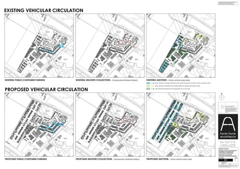
15 4.4.3 The largest delivery vehicles which require access to the site are 11/ 12 vehicle car transporters. Delivery vehicles enter the site via the Station Road access junction and then undertake a turning manoeuvre adjacent to the Hawarden Castle Hotel before vehicles are unloaded or loaded Existing delivery/ collection vehicle circulation movements are shown in Plan 3. This plan indicates that while sufficient space is provided to accommodate required vehicle movements, the area as a whole lacks formality Due to bridge height restrictions on the local highway network all delivery vehicles arrive and depart the site via Station Road to the north. 4.5 Site Operation and Circulation The operation of the site is divided into three main phases. Once transported to the site, vehicles are held in a storage area (shown in blue on the Existing Auction panel of Plan 3). Vehicles are then moved to the pre auction preparation area (highlighted in yellow), before being transferred to the sales area for the auctions (as shown in green) The Existing Layout panel on Plan 4 illustrates the current movement patterns of vehicles between the respective areas on the site. Upon delivery vehicles are moved to the storage area on the western side of the site via the central hard standing area. A secure gated access is used to separate the central hard standing area and storage area. Vehicles are then transferred in the reverse direction to the area to the rear of the Hawarden Castle Hotel where they are cleaned and prepared for auction Finally, having been prepared vehicles are transferred via the customer car park to the sales area surrounding the auction building. Vehicles can be transferred up to 20 minutes prior to an auction being held and therefore conflict can occur between vehicles being transferred to the sales area and customers parking within the site. This can cause delays to vehicles entering the site. 4.6 Car Parking The development currently provides 110 customer car parking spaces. These are predominantly located in a secure area immediately to the west of the site access junction, although a small number of spaces are also available in front of the Hawarden Castle Hotel Existing customer circulation around the car parking area is shown in Plan 3. Transport Assessment 11
16 4.6.3 It is our understanding that some on street car parking can occur on Station Road at peak auction times. While such practices are not in contravention of highway law it is our understanding that this is of safety concern to the local highways authority and local police, in particular because parked vehicles can obstruct the on street cycle lane. Transport Assessment 12
17 5 PROPOSED SITE OPERATION 5.1 Introduction Having reviewed the existing site operation Section 5 of this report provides a summary of the development proposals and how these will alter the operation of the site. 5.2 Proposed Development The application site forms a roughly rectangular area of circa 16,700sqm and is currently agricultural land The planning application proposes the development of this land as a hard standing area to be used for vehicle storage. The area will be surfaced in permeable free draining compacted hard core hardstanding material appropriate for vehicle circulation and car parking. There are no changes to the existing vehicle access to the site from Station Road proposed as part of the planning application It is not proposed to formally mark out parking bays across this new storage area, although the attached plans demonstrate an informal but orderly pattern in which it is expected vehicles would be arranged such that it would allow appropriate circulation for vehicles Although the planning application proposes the change of use of the entire 16,700sqm site area, it is not envisaged that this entire area would be converted for vehicle storage from the outset. Rather it is suggested that the implementation of this hard standing area be phased to coincide with the company s operational requirements. The attached plans provide an illustration of how this phasing could occur In addition some areas of land currently occupied by Wilsons Auctions are leased from other parties. These areas are shown on the accompanying plans. The development proposals therefore offer the opportunity to transfer vehicles stored in these areas to the new storage area as and when lease arrangements allow The development proposals will also allow the reconfiguration of the existing layout of the site to achieve a more efficient movement of vehicles around the site. This will be described in greater detail in the following paragraphs. Transport Assessment 13
18 5.2.7 Table 5.1 below provides an estimate of the approximate number of vehicles the site will be able to accommodate following the development proposals. As outlined above this information accounts for the proposed phased implementation of the new storage area, and also illustrates the potential for Wilsons Auctions to reduce their reliance on land under lease. Number of Vehicles Vehicles in Auction Area Vehicles in Storage Commercial and Plant Land in Ownership Phase 1 Phase 2 Phase 3 Leased Land Land in Ownership Leased Land Land in Ownership Leased Land Total Table 5.1: Existing Site Capacity (Vehicles) Therefore following the development proposals it is estimated that the site will have the potential to accommodate 1,054 vehicles and items of plant. As Table 5.1 highlights, while the proposals will allow a small increase in the number of vehicle held in the auction area and commercial and plant equipment, the vast majority of this increase in capacity on the site will relate to the storage of vehicles With regards employees Wilsons Auctions have advised that they anticipated the development proposals resulting in a small increase in employees, with the number of part time staff increasing from 10 to Hours of Operation It is not proposed to change public viewing hours as a result of the development proposals The development proposals will support a level of organic growth which Wilsons Auctions anticipate will be experienced in a variety of ways. However, as Table 5.1 indicates the number of vehicles held in the auction area (which includes the pre sales/ prep area and the sales area) does not materially change as a result of the development proposals. Transport Assessment 14
19 5.3.3 This suggests that the size of the auctions held is unlikely to materially differ from present as a result of the proposals. On this basis it is anticipated that the number of customers visiting the site on auction days, and therefore the developments traffic generation, is unlikely to materially increase As such it is anticipated that organic growth will be experienced in the following ways. Additional Auctions Firstly there is the potential for an additional auction to be held during the week, potentially either on a Monday or Wednesday. Should this occur then the auction would either be held at a similar time to the Tuesday or Friday auctions, meaning that customers would arrive and depart the site away from network peak hours as they do at present. Consequently should an additional auction be held it is not considered that this would have any material impact upon the local highway network or operation of the site access junction. Longer Auctions Secondly there is the potential for auctions durations to be slightly lengthened. Wilsons Auctions have confirmed that this would be achieved by starting the auctions earlier than they do at present. Given the existing schedule should auctions commence at an earlier time this would have no impact upon the local highway network peak hours, and therefore it is not considered that this proposal would have any material impact upon the operation of the local highway network Typically customers to an auction arrive and depart in a staggered manner, viewing cars pre auction and then departing once their interested lot(s) have finished. Therefore it is not considered that lengthening auctions would result in a surge in traffic movements at any one time compared to the existing situation, and therefore not considered that lengthening auctions would have any material impact upon the operation of the site access junction. Increased On Line Sales Finally Wilsons Auctions anticipate a material increase in on line sales. This would occur either as live bids submitted during an active auction, or dealer direct auctions which provide an on line timed auction (lots last 72 hours) which allow motor trade professionals to purchase stock on a daily basis. Clearly this form of organic growth will have no impact upon the traffic generation of the site. Transport Assessment 15
20 5.3.9 It is also anticipated that the site would experience an increase in customer viewings as a result of the development proposals. However, given the site currently experiences at most around 50 viewing per weekday between 0900 and 1700 (or 0900 and 2100 on a Tuesday) it is not anticipated that any increase in customer viewings would have a material impact upon the operation of the local highway network or site access junction. 5.4 Deliveries The additional storage area will result in an increase in the number of deliveries to the site, although there will be no increase in the size of vehicles beyond the 11/ 12 vehicle car transporters The increase in delivery vehicles is currently unknown and will ultimately be subject to demand. However, to provide the highways authority with a degree of comfort an assessment of the increase in delivery vehicle movements has been undertaken on the worst case assumption that deliveries increase in line with the increase in vehicle storage area (i.e. a 70% increase) On this highly robust basis the site would be expected to generate between 50 and 68 deliveries per week, which would equate to between 7 and 10 deliveries per day. This equates to an increase of between 3 and 4 deliveries per day, or approximately one delivery every two hours Such an increase in delivery vehicles will not alter the operation or safety of the local highway network, particularly given the number of developments in the vicinity of the site which already generate large vehicle movements, and the proximity of the site to the strategic highway network Following the development proposals it is still proposed that delivery vehicles undertake a turning manoeuvre and unloading to the west of the Hawarden Hotel building. However, the proposals, in particular the fence around the new overspill car park, will allow a more formalised space to be provided to assist vehicle turning movements and unloading Delivery vehicles will continue to arrive/ depart the site via Station Road to the north, and enter the site via the existing Station Road access junction The circulation of delivery vehicles is shown on Plan 3 with an AutoTRACK assessment demonstrating the turning movements of an 11/ 12 vehicle car transporter shown in Plan 6. To provide a robust analysis the track assessment has been undertaken assuming another 11/12 vehicle car transporter and a flatbed truck are already present on site. Transport Assessment 16
21 5.5 Site Operation and Circulation The post development division of the site into storage, vehicle preparation and sales areas is shown on the Proposed Auction pane on Plan This plan emphasizes that the development proposals will not materially change the number of spaces allocated to sales vehicles (and consequently the size/ duration of auctions), but does indicate the introduction of a new vehicle prep area, the implications of which are discussed below Vehicle circulation through the site following the development proposals is shown on Plan This plan indicates the proposals will allow a direct route to be provided from the vehicle unloading area to the new hardstanding storage area. This is preferable to the more convoluted route currently used. A gate will be used to provide secure vehicle access to the new storage area The proposals also include the introduction of a new pre sales area adjacent to the auction building. While some vehicles may still be prepared to the rear of the Hawarden Hotel building, the majority of vehicles will be prepared in this new area. This new pre sales area is conveniently located to allow vehicles once prepared to be moved directly into the sales area Therefore the proposals remove the requirement for the majority of pre sale vehicles to be taken through the customer car park, as is currently the case. This existing movement of vehicles has been known to cause operational difficulties both for vehicles within the customer car park, and at times for vehicles waiting to enter the site As such it is predicted that the proposals will provide an operational benefit for both the car park and site access junction (and therefore by association traffic flows on Station Road). 5.6 Car Parking The introduction of a new storage area will permit additional space within the site to be repurposed as customer overspill car parking. Transport Assessment 17
22 5.6.2 As indicated on Plan 3 it is proposed to introduce an additional area of overspill car parking on the west side of the current customer provision. This area will provide parking for around 51 vehicles, taking the total parking provision on site after Phase 1 of the development to 161 spaces. It is not proposed to formally mark out this overspill area with parking bays, however, attendants will be provided at times when the car park is in use to ensure vehicles park in an efficient manner In addition, once further hard standing storage areas are developed the opportunity will exist to relocate further storage vehicles to this area and thereby provide additional over spill parking at the centre of the site. This is indicatively shown on the Phase Three drawing on Plan 5, which shows how another circa 32 overspill parking spaces could be provided taking the total parking provision on site to 193 spaces The circulation of customer vehicles around the car parking areas is shown on Plan The provision of this additional car parking will help to address existing on street parking issues on Station Road in the vicinity of the site which have been a matter of concern for the local highways authority and local police. In particular the additional parking should help to address the existing problem of cars parking in the on street cycle lane. 5.7 Proposed Development Impact Upon Highway Safety It has been demonstrated that there are no existing accident blackspots on the highway network in the vicinity of the site access It has further been demonstrated that the proposals will not result in an increase in customer or delivery vehicle numbers which would be expected to materially alter the operation of the local highway network or site access junction with Station Road However, the proposals will result in more car parking being provided on site and therefore a reduction in on street car parking in the vicinity of the site, including in the on street cycle lane which will be to major benefit of cyclists. The only accident which has occurred on the highway network in the vicinity of the site in the last 5 years involved a cyclist so the proposals will help to address this safety issue. Transport Assessment 18
23 5.7.4 Furthermore the reduction in pre sales vehicles passing through the customer car park is likely to improve the operation of the car park, and thereby reduce the potential for queuing or delay at the site access It is therefore concluded that the proposals will be of safety benefit to the local highway network and vulnerable roads users. Transport Assessment 19
24 6 CONCLUSIONS 6.1 Introduction Vectos have been commissioned by Wilsons Auctions to provide transport and highways advice to support a change of use planning application for the development of a hardstanding vehicle storage compound at their site in Queensferry The planning application proposes the development of approximately 1.67 hectares of agricultural land to the west of the site to provide approximately 16,500 sqm of new hardstanding area which would be used by as additional vehicle storage parking The additional vehicle storage will provide the flexibility to enable business growth and will provide a major highway safety benefit of allowing additional areas within the site to be utilised as customer car parking on auction days Vehicle access to the site is to be retained from a priority controlled junction with the B5441 Station Road The following conclusions can be drawn from the report: The development is accessible by sustainable modes of travel including walking, cycling and public transport. A review of historical collision data has demonstrated that there are no existing accident blackspots in the vicinity of the site. By virtue of the increase in car parking provided on site, and the anticipated improved operation of the car park as a result of a new pre sales area, the proposals have been concluded to be of safety benefit to the local highway network, including for cyclists. The development proposals will result in an increase in vehicle storage of approximately 432 vehicles. However, it was demonstrated that the capacity of the vehicle sales area would not increase significantly. Transport Assessment 20
25 The proposals are intended to support the organic growth of Wilsons Auctions. It was demonstrated that this growth could occur in a number of forms, but that none of these would be expected to materially increase the traffic generation of the site, in particular during network peak hours, and therefore would not be expected to have a detrimental impact upon the operation of the local highway network or site access junction. The proposals would result in an increase in delivery vehicles. However, even assuming that delivery vehicle movements were to increase pro rata with the increase in vehicle storage, it has been demonstrated that the proposals would result in only between 3 and 4 additional deliveries per day. Such an increase would not have a material impact upon the operation of the local highway network or site access junction. The development would provide an additional 51 overspill car parking spaces, with the potential to increase the total provision on site to 193 customer spaces. This increase in provision would address existing on street car parking practices and improve safety for cyclists. The development would allow vehicle movements within the site to be undertaken in a more direct and efficient manner. In particular the reduction in sales vehicles passing through the customer car park would improve the operation of the car park and therefore the potential for queuing to occur at the site access junction. 6.2 Transport Assessment Conclusions The development site is in a highly sustainable location and the development proposals would not have a material detrimental impact upon either the operation or safety of the local highway network or site access junction Therefore based upon the findings of the Transport Assessment it is concluded that there are no material reasons why the development should not be granted planning consent on highways or transportation grounds. Transport Assessment 21
26 PLANS
27


28
29

30

31
32 PLAN 6 Ordnance Survey Crown copyright. All rights reserved. Licence No REV. DETAILS DRAWN CHECKED DATE Notes: DRAWN: CHECKED: DATE: SCALES: DRAWING NUMBER: REVISION:
33 APPENDICES
34 APPENDIX A


35
36 APPENDIX B

37
38 Crash Report including Vehicle and Casualty Information Crash Date: Friday, December 02, 2011 Time of Crash: 4:50:00 PM Crash Reference: M Highest Injury Severity: Slight Number of Vehicles: 2 Number of Casualties: 1 Highway Authority: Flintshire OS Grid Reference: Local Authority: Flintshire County Road Number: B5441 Road Type: Single carriageway Weather Description: Fine without high winds Road Surface Description: Dry Speed Limit: 30 Junction Control: Not Applicable Light Conditions: Carriageway Hazards: Junction Detail: Junction Pedestrian Crossing: Darkness: street lights present and lit None Not at or within 20 metres of junction No physical crossing facility within 50 metres Vehicles involved Vehicle Ref Vehicle Type Vehicle Age Driver Gender Driver Age Band Vehicle Maneouvre 1 Car (excluding private hire cars 2005 onwards) -1 Female Vehicle proceeding normally along the carriageway, not on a bend 2 Pedal cycle -1 Female Vehicle proceeding normally along the carriageway, not on a bend For more information about the data please visit: and 4/5/2016 1:38:40 PM Supporting the United Nations' Decade of Action for Road Safety Page 1 of 2


39 Crash Report including Vehicle and Casualty Information Casualties Vehicle Ref Casualty Ref Injury Severity Casualty Class Gender Age Band Pedestrian Location Pedestrian Movement 2 1 Slight Driver or rider Female Unknown or other Unknown or other For more information about the data please visit: and 4/5/2016 1:38:40 PM Supporting the United Nations' Decade of Action for Road Safety Page 2 of 2
54 Parkway Drive, Rosedale Proposed Residential / Commercial Development. Transportation Assessment Report. 30 April 2018
 54 Parkway Drive, Rosedale Proposed Residential / Commercial Development Transportation Assessment Report 30 April 2018 Project: Report title: Document reference: 54 Parkway Drive, Rosedale Transportation
Post Opening Project Evaluation. M6 Toll
 M6 Toll Five Post Years Opening After Study: Project Summary Evaluation Report Post Opening Project Evaluation M6 Toll Five Years After Study Summary Report October 2009 Document History JOB NUMBER: 5081587/905
PROPOSED TRAFFIC RESOLUTION
 Reference Number: TR 50-18 Location:, Brooklyn Bus Hub - Brooklyn Proposal: Information: To provide new bus stops to create a Bus hub location on Cleveland Street, Brooklyn, as part of Wellington s new
MERSEYSIDE ROUTE UTILISATION STRATEGY (RUS): CHESHIRE COUNTY COUNCIL S COMMENTS ON THE DRAFT FOR CONSULTATION SECTION 2: CHESHIRE SCHEMES AND ISSUES
: CHESHIRE COUNTY COUNCIL S COMMENTS ON THE DRAFT FOR CONSULTATION SECTION 2: CHESHIRE SCHEMES AND ISSUES") MERSEYSIDE ROUTE UTILISATION STRATEGY (RUS): CHESHIRE COUNTY COUNCIL S COMMENTS ON THE DRAFT FOR CONSULTATION 1.0 INTRODUCTION Cheshire County Council welcomes the opportunity extended to stakeholders
MERSEYSIDE ROUTE UTILISATION STRATEGY (RUS): CHESHIRE COUNTY COUNCIL S COMMENTS ON THE DRAFT FOR CONSULTATION 1.0 INTRODUCTION Cheshire County Council welcomes the opportunity extended to stakeholders
TRAFFIC SURVEY REPORT HARVINGTON PT1 (CREST HILL)
") TRAFFIC SURVEY REPORT HARVINGTON PT1 ( HILL) October 20-24th 2014 Conducted voluntarily by the residents of Harvington Village. This report has been prepared in light of the planning application W14/01788/OU
TRAFFIC SURVEY REPORT HARVINGTON PT1 ( HILL) October 20-24th 2014 Conducted voluntarily by the residents of Harvington Village. This report has been prepared in light of the planning application W14/01788/OU
TRANSPORTATION REVIEW
 TRANSPORTATION REVIEW - PROPOSED MIX OF LAND USES IS CONSISTENT WITH THE CITY S UNDER THE GRANVILLE BRIDGE POLICIES THAT AIM TO MEET NEIGHBOURING RESIDENTS SHOPPING NEEDS AND REDUCE RELIANCE ON AUTOMOBILE
Submission to Greater Cambridge City Deal
 What Transport for Cambridge? 2 1 Submission to Greater Cambridge City Deal By Professor Marcial Echenique OBE ScD RIBA RTPI and Jonathan Barker Introduction Cambridge Futures was founded in 1997 as a
TRAFFIC ENGINEERING ASSESSMENT MOUNT EDEN ROAD, MOUNT EDEN
 12 September 2017 Iain McManus Civitas Planning Consultants PO Box 47020 Ponsonby AUCKLAND 1144 Dear Iain, TRAFFIC ENGINEERING ASSESSMENT 43-45 45 MOUNT EDEN ROAD, MOUNT EDEN As requested, we have prepared
Construction Realty Co.
 MEMORANDUM TO: FROM : Jeff Pickus Construction Realty Co. Luay R. Aboona, PE Principal 9575 West Higgins Road, Suite 400 Rosemont, Illinois 60018 p: 847-518-9990 f: 847-518-9987 DATE: May 22, 2014 SUBJECT:
Clean Harbors Canada, Inc.
 Clean Harbors Canada, Inc. Proposed Lambton Landfill Expansion Environmental Assessment Terms of Reference Transportation Assessment St. Clair Township, Ontario September 2009 itrans Consulting Inc. 260
Project : A Prepared by: Jack Wellings / Andrew Hughes. Client: Wembdon Parish Council Approved by: Philip Weatherhead
 Technical Note 01 Project: Wembdon Neighbourhood Plan Office: Wellington Project : A108388 Prepared by: Jack Wellings / Andrew Hughes Client: Wembdon Parish Council Approved by: Philip Weatherhead Date:
WATFORD LOCAL PLAN PART 2. Review of Car Parking Policy and Standards. Evidence Base. February 2012
 WATFORD LOCAL PLAN PART 2 Review of Car Parking Policy and Standards Evidence Base February 2012 1.0 Background 1.1 The Watford District Plan 2000 contains various policies relating to the provision of
Residential Development Bearna Engineering Services Report
 Residential Development Bearna Engineering Services Report APPENDIX D Job No: B861G TRAFFIC REPORT TRAFFIC IMPACT ASSESSMENT RESIDENTIAL DEVELOPMENT, BEARNA, CO. GALWAY Burkeway Homes Project No. B861
PS 127 Abnormal / Indivisible Loads Policy
 PS 127 Abnormal / Indivisible Loads Policy June 2017 Version 1.5 Statement of legislative compliance This document has been drafted to comply with the general and specific duties in the Equality Act 2010;
Downtown Lee s Summit Parking Study
 Downtown Lee s Summit Parking Study As part of the Downtown Lee s Summit Master Plan, a downtown parking and traffic study was completed by TranSystems Corporation in November 2003. The parking analysis
BUS SERVICES IN CHAMBERLAYNE ROAD NW10
 INTRODUCTION BUS SERVICES IN CHAMBERLAYNE ROAD NW10 1 LONDON BUSES 1. This note reviews the issues in Chamberlayne Road, Kensal Rise. It covers the range of bus routes in the area, their characteristics
MILLERSVILLE PARK TRAFFIC IMPACT ANALYSIS ANNE ARUNDEL COUNTY, MARYLAND
 MILLERSVILLE PARK TRAFFIC IMPACT ANALYSIS ANNE ARUNDEL COUNTY, MARYLAND Prepared for: Department of Public Works Anne Arundel County Prepared by: URS Corporation 4 North Park Drive, Suite 3 Hunt Valley,
South Gloucestershire Challenge Fund and Cycle Ambition Fund
 South Gloucestershire Challenge Fund and Cycle Ambition Fund The Challenge Fund A4174 scheme is coordinated and delivered by South Gloucestershire Council who were awarded 14 million pounds from the Department
Baddow Road Bus Gate Frequently Asked Questions May 2018
 Baddow Road Bus Gate Frequently Asked Questions May 2018 Contents page Key Information: 1. What is the Bus Gate? 2. Why is it being proposed? 3. What alternatives have been considered? 4. What are the
BARRHAVEN FELLOWSHIP CRC 3058 JOCKVALE ROAD OTTAWA, ONTARIO TRANSPORTATION BRIEF. Prepared for:
 BARRHAVEN FELLOWSHIP CRC 3058 JOCKVALE ROAD OTTAWA, ONTARIO TRANSPORTATION BRIEF Prepared for: Barrhaven Fellowship CRC 3058 Jockvale Road Ottawa, ON K2J 2W7 December 7, 2016 116-649 Report_1.doc D. J.
TRAFFIC PARKING ANALYSIS
 TRAFFIC PARKING ANALYSIS NAPA FLEA MARKET COUNTY OF NAPA Prepared for: Tom Harding Napa-Vallejo Flea Market 33 Kelly Road American Canyon, CA 9453 Prepared by: 166 Olympic Boulevard, Suite 21 Walnut Creek,
Annex I. Transport Assessment
 Annex I Transport Assessment KEADBY DEVELOPMENTS LIMITED KEADBY II POWER STATION KEADBY, NORTH LINCOLNSHIRE TRANSPORT ASSESSMENT OCTOBER 2015 KEADBY DEVELOPMENTS LIMITED KEADBY II POWER STATION KEADBY,
TRAFFIC IMPACT STUDY. USD #497 Warehouse and Bus Site
 TRAFFIC IMPACT STUDY for USD #497 Warehouse and Bus Site Prepared by: Jason Hoskinson, PE, PTOE BG Project No. 16-12L July 8, 216 145 Wakarusa Drive Lawrence, Kansas 6649 T: 785.749.4474 F: 785.749.734
APPENDIX 7.1 Annex E. South Kyle Wind Farm Abnormal Load Traffic Management Plan VATTENFALL
 APPENDIX 7.1 Annex E South Kyle Wind Farm Abnormal Load Traffic Management Plan VATTENFALL Ref: 402-03640-00006 March 2013 VATTENFALL i Ref: 402.03640.00006 CONTENTS 1.0 INTRODUCTION... 2 1.1 Proposed
Table of Contents INTRODUCTION... 3 PROJECT STUDY AREA Figure 1 Vicinity Map Study Area... 4 EXISTING CONDITIONS... 5 TRAFFIC OPERATIONS...
 Crosshaven Drive Corridor Study City of Vestavia Hills, Alabama Table of Contents INTRODUCTION... 3 PROJECT STUDY AREA... 3 Figure 1 Vicinity Map Study Area... 4 EXISTING CONDITIONS... 5 TRAFFIC OPERATIONS...
TECHNICAL MEMORANDUM. Part A: Introduction
 TECHNICAL MEMORANDUM To: David J. Decker Decker Properties, Inc. 5950 Seminole Centre Ct. Suite 200 Madison, Wisconsin 53711 608-663-1218 Fax: 608-663-1226 www.klengineering.com From: Mike Scarmon, P.E.,
BOARD OF ZONING ADJUSTMENT STAFF REPORT Date: November 7, 2016
 # 2 HOLDOVER Revised ZON2016-01992 BOARD OF ZONING ADJUSTMENT STAFF REPORT Date: November 7, 2016 CASE NUMBER 6065 APPLICANT NAME LOCATION VARIANCE REQUEST ZONING ORDINANCE REQUIREMENT ZONING AREA OF PROPERTY
Controlled Parking Zones Commentary
 Controlled Parking Zones Commentary November 2012 Residents Association Controlled Parking Zones Commentary 244884 TPN ITQ 001 C http://localhost:3579/ahjycdovl0vvtkfqau1tl0rpq1vnru5uly9ilw FjdGlvbiUzYV9hX2FmaW5kaXRlbWluZm9hY3Rpb25fYWl0ZW1fY19hMT
Colston Budd Rogers & Kafes Pty Ltd as Trustee for C & B Unit Trust ABN
 as Trustee for C & B Unit Trust ABN 27 623 918 759 Our Ref: 20 July, 2017 TR/10419/jj Transport Planning Traffic Studies Parking Studies Frasers Property Australia PO Box 4148 SHELLHARBOUR NSW 2529 Attention:
Transport Assessment. December TTP Consulting
 Transport Assessment December 2016 TTP Consulting Contents 1 INTRODUCTION... 1 2 POLICY... 3 3 BASELINE CONDITIONS... 8 The Site... 8 The Surrounding Area... 9 Local Road Network... 9 Accessibility by
THE CORNERSTONE APARTMENTS TRAFFIC IMPACT STUDY R&M PROJECT NO
 THE CORNERSTONE APARTMENTS SITUATED AT N/E/C OF STAUDERMAN AVENUE AND FOREST AVENUE VILLAGE OF LYNBROOK NASSAU COUNTY, NEW YORK TRAFFIC IMPACT STUDY R&M PROJECT NO. 2018-089 September 2018 50 Elm Street,
EXECUTIVE SUMMARY. The following is an outline of the traffic analysis performed by Hales Engineering for the traffic conditions of this project.
 EXECUTIVE SUMMARY This study addresses the traffic impacts associated with the proposed Shopko redevelopment located in Sugarhouse, Utah. The Shopko redevelopment project is located between 1300 East and
committee report General Permitted Development Order SPT response to consultation
 committee report General Permitted Development Order SPT response to consultation Committee Strategy and Programmes Date of meeting 24 June 2011 Date of report 1 June 2011 Report by Assistant Chief Executive
Craigieburn Employment Precinct North and English Street
 Craigieburn Employment Precinct North and English Street METROPOLITAN PLANNING AUTHORITY Intersection Analyses 7 February 2014 Intersection Analyses Craigieburn Employment Precinct North and English Street
M6 TOLL TRAFFIC MONITORING STUDY
 ` M6 TOLL TRAFFIC MONITORING STUDY Traffic Impact Study Report POST OPENING PROJECT EVALUATION M6 TOLL TRAFFIC IMPACT STUDY REPORT JOB NUMBER: 4416515.1525.600 DOCUMENT REF: M6 Toll Traffic Impact Study
12 April Leakes Pty Ltd 211 Waverley Road EAST MALVERN VIC Attention: Joseph Nasr. Dear Joe,
 Our Ref: Contact: CG120569:VG Valentine Gnanakone Leakes Pty Ltd 211 Waverley Road EAST MALVERN VIC 3145 Attention: Joseph Nasr Dear Joe, 690 DERRIMUT ROAD PROPOSED RESIDENTIAL SUBDIVISION Further to our
Response to. Department for Transport Consultation Paper. Allowing Learner Drivers To Take Lessons on Motorways
 Response to Department for Transport Consultation Paper Allowing Learner Drivers To Take Lessons on Motorways 6 February 2017 Introduction This is RoSPA s response to the Department for Transport s consultation
Traffic Impact Analysis West Street Garden Plots Improvements and DuPage River Park Garden Plots Development Naperville, Illinois
 Traffic Impact Analysis West Street Garden Plots Improvements and DuPage River Park Garden Plots Development Naperville, Illinois Submitted by April 9, 2009 Introduction Kenig, Lindgren, O Hara, Aboona,
Traffic Management Plan and Queuing Analysis Lakehill Preparatory School Z Hillside Drive, Dallas, TX October 27, 2015
 Traffic Management Plan and Queuing Analysis Lakehill Preparatory School Z145-235 2720 Hillside Drive, Dallas, TX October 27, 2015 Introduction: The Lakehill Preparatory School is located on the northeast
Madison BRT Transit Corridor Study Proposed BRT Operations Plans
 Madison BRT Transit Corridor Study Proposed BRT Operations Plans This paper presents a description of the proposed BRT operations plan for use in the Madison BRT Transit Corridor Study. The objective is
Click to edit Master title style
 Nelson/Nygaard Consulting Associates SERVICE IMPROVEMENT STRATEGIES September 22, 2015 1 PROJECT OVERVIEW & WORK TO DATE 1. Extensive stakeholder involvement Throughout 2. System and market assessment
Traffic Impact Study Speedway Gas Station Redevelopment
 Traffic Impact Study Speedway Gas Station Redevelopment Warrenville, Illinois Prepared For: Prepared By: April 11, 2018 Table of Contents 1. Introduction... 1 2. Existing Conditions... 4 Site Location...
Chairperson and Committee Members REGULATORY MANAGEMENT COMMITTEE 3 SEPTEMBER 2015
 Chairperson and Committee Members REGULATORY MANAGEMENT COMMITTEE 3 SEPTEMBER 2015 SPEED LIMIT CHANGE ON KĀPITI ROAD PURPOSE OF REPORT Meeting Status: Public Purpose of Report: For Decision 1 The purpose
Craig Scheffler, P.E., PTOE HNTB North Carolina, P.C. HNTB Project File: Subject
 TECHNICAL MEMORANDUM To Kumar Neppalli Traffic Engineering Manager Town of Chapel Hill From Craig Scheffler, P.E., PTOE HNTB North Carolina, P.C. Cc HNTB Project File: 38435 Subject Obey Creek TIS 2022
RE: A Traffic Impact Statement for a proposed development on Quinpool Road
 James J. Copeland, P.Eng. GRIFFIN transportation group inc. 30 Bonny View Drive Fall River, NS B2T 1R2 May 31, 2018 Ellen O Hara, P.Eng. Project Engineer DesignPoint Engineering & Surveying Ltd. 200 Waterfront
Proposed Readymix Regional Distribution Centre at Rooty Hill Traffic Impact Study
 Proposed Readymix Regional Distribution Centre at Rooty Hill Traffic Impact Study 23rd June 2005 Irwinconsult Pty Ltd Suite 602, Level 6 504 Pacific Hwy St Leonards NSW 2065, Australia ABN 12 050 883 657
Appendix J Traffic Impact Study
 MRI May 2012 Appendix J Traffic Impact Study Level 2 Traffic Assessment Limited Impact Review Appendix J [This page was left blank intentionally.] www.sgm-inc.com Figure 1. Site Driveway and Trail Crossing
PROPOSED BROILER FARMS
 PROPOSED BROILER FARMS BARINGHUP WEST Traffic Engineering Assessment Prepared for PAVILION PARTNERS MARCH, 2014 OUR REFERENCE: 16853R9457 PROPOSED BROILER FARMS BARINGHUP WEST Traffic Engineering Assessment
4. Transportation Plan
 The sizes of the most suitable sites are indicated in Table 4.3.6.2. Table 4.3.6.2: Site Sizes and Potential Development Area Potential Development Site Site Size (m 2 ) Area m 2 (3 Floors) D1 29,000 87,000
Letter EL652 City of Mercer Island. Page 1. No comments n/a
 Letter EL652 City of Mercer Island Page 1 No comments n/a Page 2 Response to comment EL652 1 Section 4.5.3 of the Final EIS presents the range of potential impacts of the project. This project also lists
Draft Marrickville Car Share Policy 2014
 Draft Marrickville Car Share Policy 2014 1. Background 1.1. Marrickville Council has supported car sharing in the LGA since 2007 as part of a holistic approach to encouraging more sustainable modes of
2 MAJOR MACKENZIE DRIVE WEST JOG ELIMINATION AT HUNTINGTON ROAD CITY OF VAUGHAN
 2 MAJOR MACKENZIE DRIVE WEST JOG ELIMINATION AT HUNTINGTON ROAD CITY OF VAUGHAN The Transportation Services Committee recommends the adoption of the recommendations contained in the following report dated
THE CORPORATION OF THE TOWNSHIP OF MIDDLESEX CENTRE BY-LAW NUMBER
 THE CORPORATION OF THE TOWNSHIP OF MIDDLESEX CENTRE BY-LAW NUMBER 2006-052 BEING A BY-LAW TO REGULATE AND CONTROL PARKING WITHIN THE TOWNSHIP OF MIDDLESEX CENTRE WHEREAS the Municipal Act authorizes local
1. What are your experiences of parking on a footway or on a road next to a dropped kerb or double parking?
 The City of Edinburgh Council s Response to the Local Government and Regeneration Committee s call for evidence on the Footway Parking and Double Parking (Scotland) Bill Thank you for allowing The City
STH 60 Northern Reliever Route Feasibility Study Report
 #233087 v3 STH 60 Northern Reliever Route Feasibility Study Report Washington County Public Works Committee Meeting September 28, 2016 1 STH 60 Northern Reliever Route Feasibility Study Hartford Area Development
TRAFFIC IMPACT STUDY VICDOM BROCK ROAD PIT EXPANSION
 TRAFFIC IMPACT STUDY VICDOM BROCK ROAD PIT EXPANSION TOWNSHIP OF UXBRIDGE P/N 05-1993 June 2011 Revised -August 2011 Prepared by: Skelton, Brumwell & Associates Inc. 93 Bell Farm Road, Suite 107 Barrie,
BETHLEHEM MISSIONS TRUST CAMPUS
 BETHLEHEM MISSIONS TRUST CAMPUS Prepared For: Prepared By: Wasley Knell Consultants PO Box 5015, Mount Maunganui, 3150 BruceWRobinson@msn.com/(027) 4515685 Table of Contents Introduction... 3 Site Vicinity...
Pace Bus Depot Location Analysis
 Pace Bus Depot Location Analysis Key Notes 1. Options refer to conceptual sketches prepared by Kimley Horn. 2. The depot is assumed to accommodate Pace routes as they currently exist: 17 routes on the
Welcome. Hello and welcome to this information stall about our proposals for the expansion of the Orchard Centre.
 Welcome Hello and welcome to this information stall about our proposals for the expansion of the Orchard Centre. Our proposals for the expansion of the Orchard Centre are part of a multi-million pound
Welcome. Public Open House Schedule. Super 8 West Kelowna 1655 Westgate Rd, West Kelowna. West Kelowna. Wednesday, March 2, :00 p.m. 8:00 p.m.
 Welcome Thank you for attending this Community Engagement on improvements to the Boucherie Road and Westlake Road intersections on Highway 97 in the Central Okanagan. Public Open House Schedule Location
US 81 Bypass of Chickasha Environmental Assessment Public Meeting
 US 81 Bypass of Chickasha Environmental Assessment Public Meeting March 14, 2013 Introductions ODOT FHWA SAIC Meeting Purpose Present need for bypass Provide responses to 10/04/11 public meeting comments
CITY OF LONDON STRATEGIC MULTI-YEAR BUDGET ADDITIONAL INVESTMENTS BUSINESS CASE # 6
 2016 2019 CITY OF LONDON STRATEGIC MULTI-YEAR BUDGET ADDITIONAL INVESTMENTS BUSINESS CASE # 6 STRATEGIC AREA OF FOCUS: SUB-PRIORITY: STRATEGY: INITIATIVE: INITIATIVE LEAD(S): BUILDING A SUSTAINABLE CITY
Trip Generation Study: Provo Assisted Living Facility Land Use Code: 254
 Trip Generation Study: Provo Assisted Living Facility Land Use Code: 254 Introduction The Brigham Young University Institute of Transportation Engineers (BYU ITE) student chapter completed a trip generation
UNINTENDED CONSEQUENCE OF THE ELECTRIC VEHICLE REVOLUTION
 UNINTENDED CONSEQUENCE OF THE ELECTRIC VEHICLE REVOLUTION By Tom Grahamslaw and Paul Marsh THROUGH THE NEWS AND MEDIA, ROAD USERS ARE BECOMING MORE AWARE THAT WE ARE NOW SEEING A TRANSITION FROM THE TRADITIONAL
More persons in the cars? Status and potential for change in car occupancy rates in Norway
 Author(s): Liva Vågane Oslo 2009, 57 pages Norwegian language Summary: More persons in the cars? Status and potential for change in car occupancy rates in Norway Results from national travel surveys in
DUNMORE QUARRY. Transport Management Plan. Boral Resources (NSW) Pty Ltd 4/04/2016. Prepared for:
 Pty Ltd 4/04/2016. Prepared for:") DUNMORE QUARRY Transport Management Plan Prepared for: Boral Resources (NSW) Pty Ltd 4/04/2016 The Transport Planning Partnership Pty Ltd ACN: 607 079 005 1609_Dunmore TMP Final DUNMORE QUARRY Transport
DUNMORE QUARRY Transport Management Plan Prepared for: Boral Resources (NSW) Pty Ltd 4/04/2016 The Transport Planning Partnership Pty Ltd ACN: 607 079 005 1609_Dunmore TMP Final DUNMORE QUARRY Transport
TRAVEL DEMAND FORECASTS
 Jiangxi Ji an Sustainable Urban Transport Project (RRP PRC 45022) TRAVEL DEMAND FORECASTS A. Introduction 1. The purpose of the travel demand forecasts is to assess the impact of the project components
TORONTO TRANSIT COMMISSION REPORT NO.
 Form Revised: February 2005 TORONTO TRANSIT COMMISSION REPORT NO. MEETING DATE: October 24, 2012 SUBJECT: DOWNTOWN RAPID TRANSIT EXPANSION STUDY (DRTES) PHASE 1 STRATEGIC PLAN ACTION ITEM RECOMMENDATIONS
TRAFFIC IMPACT STUDY DERRY GREEN CORPORATE BUSINESS PARK MILTON SECONDARY PLAN MODIFICATION
 TRAFFIC IMPACT STUDY DERRY GREEN CORPORATE BUSINESS PARK MILTON SECONDARY PLAN MODIFICATION TRAFFIC IMPACT STUDY DERRY GREEN CORPORATE BUSINESS PARK MILTON SECONDARY PLAN MODIFICATION DECEMBER 24 UPDATED
TRAFFIC IMPACT ANALYSIS
 TRAFFIC IMPACT ANALYSIS Emerald Isle Commercial Development Prepared by SEPI Engineering & Construction Prepared for Ark Consulting Group, PLLC March 2016 I. Executive Summary A. Site Location The Emerald
MERIVALE PRIORITY SQUARE 2852 MERIVALE ROAD CITY OF OTTAWA TRANSPORTATION BRIEF. Prepared for: ONT Inc. 25 Winding Way Nepean, Ontario K2C 3H1
 MERIVALE PRIORITY SQUARE 2852 MERIVALE ROAD CITY OF OTTAWA TRANSPORTATION BRIEF Prepared for: 2190986ONT Inc. 25 Winding Way Nepean, Ontario K2C 3H1 October 6, 2010 110-502 Report_1.doc D. J. Halpenny
APPENDIX VMT Evaluation
 APPENDIX 2.7-2 VMT Evaluation MEMORANDUM To: From: Mr. Jonathan Frankel New Urban West, Incorporated Chris Mendiara LLG, Engineers Date: May 19, 2017 LLG Ref: 3-16-2614 Subject: Villages VMT Evaluation
Appendix I: Parking Assessments
 Portishead Branch Line (MetroWest Phase1) Environmental Impact Assessment Appendix I: Parking Assessments Prepared for West of England Councils September 217 1 The Square Temple Quay Bristol BS1 6DG United
Town of Londonderry, New Hampshire NH Route 28 Western Segment Traffic Impact Fee Methodology
 Town of Londonderry, New Hampshire NH Route 28 Western Segment Traffic Impact Fee Methodology Prepared by the Londonderry Community Development Department Planning & Economic Development Division Based
Code of Practice v1.8. For the use by buses and coaches of the University of Bath
 11 KINGSMEAD SQUARE BATH BA1 2AB T. 01225 444011 F. 01225 444550 E. bath@ima-tp.com Job Name: University of Bath Job N o. IMA-09-049 Date: 13 th October 2010 Reference: IMA Code of Practice v1.8 For the
BORAL CONCRETE GLENORIE
 BORAL CONCRETE GLENORIE > Glenorie Progress Association meeting 14 March 2018 Glenorie RSL Club Glenorie A recap of our last discussion (Oct 2017)... Who are we? Boral Concrete (NSW/ACT) is part of the
IV. ENVIRONMENTAL IMPACT ANALYSIS K.2. PARKING
 IV. ENVIRONMENTAL IMPACT ANALYSIS K.2. PARKING ENVIRONMENTAL SETTING The following analysis summarizes the findings and conclusions of the Traffic Analysis (Traffic Study), prepared by The Mobility Group,
Alpine Highway to North County Boulevard Connector Study
 Alpine Highway to North County Boulevard Connector Study prepared by Avenue Consultants March 16, 2017 North County Boulevard Connector Study March 16, 2017 Table of Contents 1 Summary of Findings... 1
Public Meeting: Metropolitan Washington Airports Authority (MWAA) TNC (Transportation Network Company) Lot on S. Eads Street
 TNC (Transportation Network Company) Lot on S. Eads Street") Public Meeting: Metropolitan Washington Airports Authority (MWAA) TNC (Transportation Network Company) Lot on S. Eads Street Department of Environmental Services, Transportation Division Sept. 27, 2018
Public Meeting: Metropolitan Washington Airports Authority (MWAA) TNC (Transportation Network Company) Lot on S. Eads Street Department of Environmental Services, Transportation Division Sept. 27, 2018
LAWRENCE TRANSIT CENTER LOCATION ANALYSIS 9 TH STREET & ROCKLEDGE ROAD / 21 ST STREET & IOWA STREET LAWRENCE, KANSAS
 LAWRENCE TRANSIT CENTER LOCATION ANALYSIS 9 TH STREET & ROCKLEDGE ROAD / 21 ST STREET & IOWA STREET LAWRENCE, KANSAS TRAFFIC IMPACT STUDY FEBRUARY 214 OA Project No. 213-542 TABLE OF CONTENTS 1. INTRODUCTION...
2.0 Development Driveways. Movin Out June 2017
 Movin Out June 2017 1.0 Introduction The proposed Movin Out development is a mixed use development in the northeast quadrant of the intersection of West Broadway and Fayette Avenue in the City of Madison.
I101 Motorsport Precinct
 I101. Motorsport I101.1. Precinct description The Motorsport Precinct applies to three of Auckland s motorsport parks: Colin Dale Park; Rosebank Road; and Waikaraka Park. The precinct does not include
TRAFFIC SIGNAL DESIGN REPORT KING OF PRUSSIA ROAD & RAIDER ROAD RADNOR TOWNSHIP PENNSYLVANIA
 TRAFFIC SIGNAL DESIGN REPORT KING OF PRUSSIA ROAD & RAIDER ROAD RADNOR TOWNSHIP PENNSYLVANIA PREPARED FOR: UNIVERSITY OF PENNSYLVANIA HEALTH SYSTEM 34 CIVIC CENTER BOULEVARD PHILADELPHIA, PA 1987 (61)
The Eastern Connector Study November, 2007 planning for the future
 The Eastern Connector Study November, 2007 planning for the future In late 2006, Albemarle County and the City of Charlottesville jointly initiated the Eastern Connector Corridor Study. The Project Team
The Engineering Department recommends Council receive this report for information.
 CORPORATE REPORT NO: R161 COUNCIL DATE: July 23, 2018 REGULAR COUNCIL TO: Mayor & Council DATE: July 19, 2018 FROM: General Manager, Engineering FILE: 8740-01 SUBJECT: Surrey Long-Range Rapid Transit Vision
TRAFFIC IMPACT ASSESSMENT PART OF AN ENVIRONMENTAL IMPACT ASSESSMENT FOR THE KEBRAFIELD ROODEPOORT COLLIERY IN THE PULLEN S HOPE AREA
 TRAFFIC IMPACT ASSESSMENT PART OF AN ENVIRONMENTAL IMPACT ASSESSMENT FOR THE KEBRAFIELD ROODEPOORT COLLIERY IN THE PULLEN S HOPE AREA 20 March 2014 Report prepared by: Corli Havenga Transportation Engineers
A9 Data Monitoring and Analysis Report. January Content. 1. Executive Summary. 2. Overview. 3. Purpose. 4. Baseline Data Sources
 A9 Data Monitoring and Analysis Report January 2016 Content 1. Executive Summary 2. Overview 3. Purpose 4. Baseline Data Sources 5. Casualty Analysis 6. Vehicle Speed Data 7. Incident Frequency & Impact
St George's Barracks, Edith Weston
 [Type text] [Type text] [Type text] St George's Barracks, Edith Weston County Council FINAL Project Number: 60554946 April 2018 Quality information Prepared by Checked by Approved by Henry Eyre Graduate
DOWNTOWN PARKING STUDY AND STRATEGIC PLAN
 INTRODUCTION This report includes a summary of several key components of the Rapid City Downtown Parking Study and Strategic Plan, including: Current Conditions Analysis (Inventory and Occupancy and Length
BARRABOOL HILLS SHOPPING CENTRE
 BARRABOOL HILLS SHOPPING CENTRE PROVINCE BOULEVARD, HIGHTON Traffic Engineering Assessment Prepared for LASCORP DEVELOPMENT GROUP (AUST) PTY LTD MARCH 2012 OUR REFERENCE: 12073R7221FINAL BARRABOOL HILLS
Traffic Engineering Study
 Traffic Engineering Study Bellaire Boulevard Prepared For: International Management District Technical Services, Inc. Texas Registered Engineering Firm F-3580 November 2009 Executive Summary has been requested
9. Downtown Transit Plan
 CORRADINO 9. Downtown Transit Plan KAT Transit Development Plan As part of the planning process for the TDP, an examination of downtown transit operations was conducted. The Downtown Transit Plan 1 is
STRATEGIC PRIORITIES AND POLICY COMMITTEE MAY 5, 2016
 STRATEGIC PRIORITIES AND POLICY COMMITTEE MAY 5, 2016 Shift Rapid Transit Initiative Largest infrastructure project in the city s history. Rapid Transit initiative will transform London s public transit
Pedestrians, Cars, Buses and Trains? Considerations for Rapid Transit Service at Western University
 Pedestrians, Cars, Buses and Trains? Considerations for Rapid Transit Service at Western University Shift: The City of London s Rapid Transit Proposal Shift: The City of London s Rapid Transit Proposal
Table Existing Traffic Conditions for Arterial Segments along Construction Access Route. Daily
 5.8 TRAFFIC, ACCESS, AND CIRCULATION This section describes existing traffic conditions in the project area; summarizes applicable regulations; and analyzes the potential traffic, access, and circulation
The following section summarises the present conditions related to transportation for the proposed development of the Matimba B Power Station:
 14. TRAFFIC AND TRANSPORT 14.1. Status Quo Conditions The following section summarises the present conditions related to transportation for the proposed development of the Matimba B Power Station: 14.1.1.
On June 11, 2012, the Park Board approved the installation of three electric vehicle charging stations along Beach Avenue.
 January 8, 2017 TO: Park Board Chair and Commissioners FROM: General Manager Vancouver Board of Parks and Recreation SUBJECT: Electric Vehicle Charging Stations New Park Board Locations RECOMMENDATION
TRAFFIC ENGINEERING SERVICES TRAFFIC IMPACT STATEMENT NATREF CLEAN FUELS II, SASOLBURG, FREE STATE. October 2013 Revised: 2.0
 TRAFFIC ENGINEERING SERVICES TRAFFIC IMPACT STATEMENT NATREF CLEAN FUELS II, SASOLBURG, FREE STATE October 2013 Revised: 2.0 Quality Management Issue/revision Issue 1 Issue 2 Remarks Draft Final Date 30
Lacey Gateway Residential Phase 1
 Lacey Gateway Residential Phase Transportation Impact Study April 23, 203 Prepared for: Gateway 850 LLC 5 Lake Bellevue Drive Suite 02 Bellevue, WA 98005 Prepared by: TENW Transportation Engineering West
Pupil Referral Unit (PRU), Land to the rear of Cockett House, Swansea.
, Land to the rear of Cockett House, Swansea.") Pupil Referral Unit (PRU), Land to the rear of Cockett House,. Transport Statement Education 26 th October 2017 Quality information Prepared by Checked by Approved by Spiro Panagi Principal Consultant
Pupil Referral Unit (PRU), Land to the rear of Cockett House,. Transport Statement Education 26 th October 2017 Quality information Prepared by Checked by Approved by Spiro Panagi Principal Consultant