Oklahoma Corporation Commission Oil & Gas Conservation Division Post Office Box Oklahoma City, Oklahoma Rule 165:
|
|
|
- Edgar Small
- 5 years ago
- Views:
Transcription
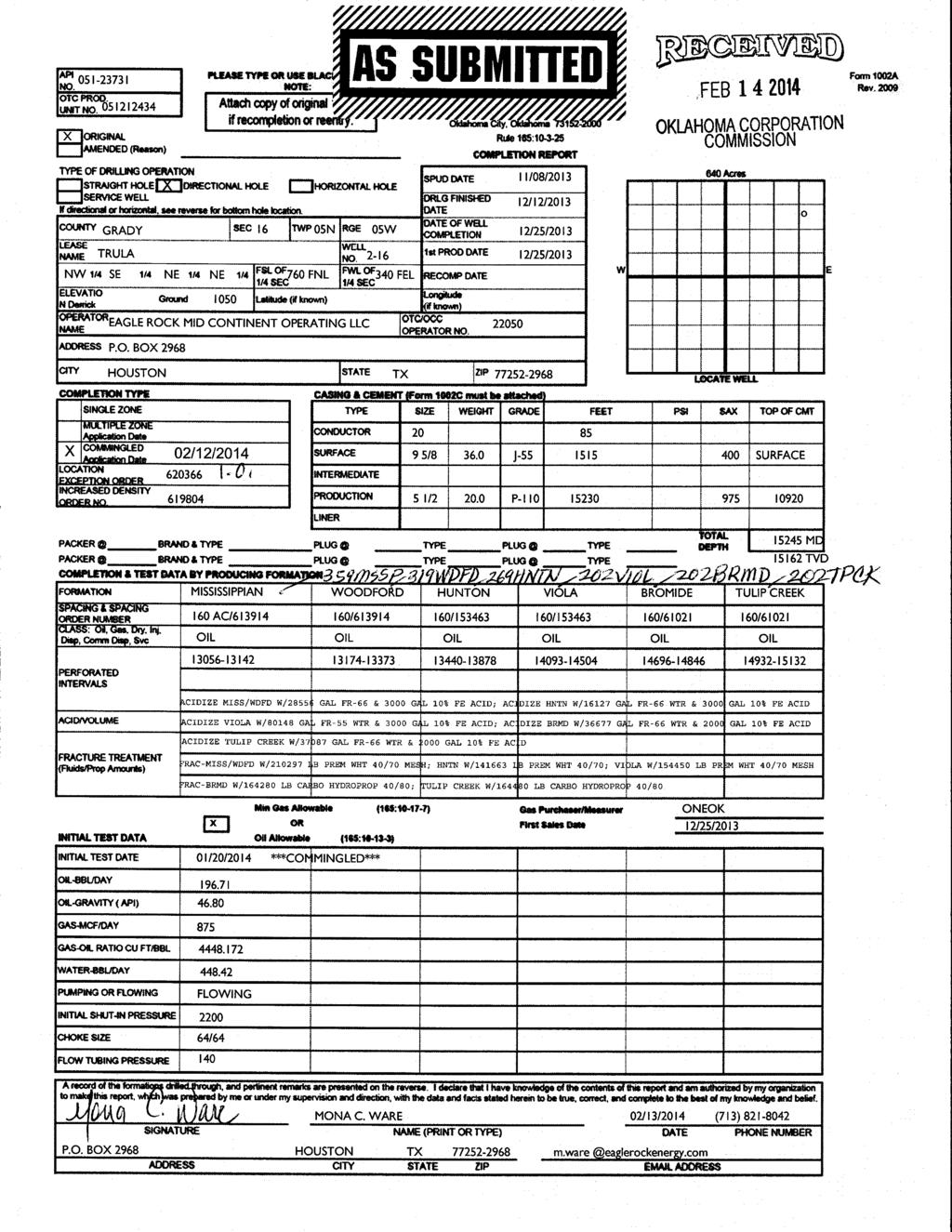
1 Oklahoma Corporation Commission Oil & Gas Conservation Division Post Office Box Oklahoma City, Oklahoma Rule 165: Form 1002A API No.: OTC Prod. Unit No.: Completion Report Spud Date: November 08, 2013 Drilling Finished Date: December 12, st Prod Date: December 25, 2013 Completion Date: December 25, 2013 Drill Type: DIRECTIONAL HOLE Min Gas Allowable: Yes Well Name: TRULA 2-16 Purchaser/Measurer: ONEOK Location: Operator: GRADY 16 5N 5W NW SE NE NE 760 FNL 340 FEL of 1/4 SEC Latitude: Longitude: Derrick Elevation: 0 Ground Elevation: 1050 EAGLE ROCK MID-CONTINENT OPERATING LLC PO BOX LOUISIANA ST STE 2700 HOUSTON, TX First Sales Date: 12/25/2013 Completion Type Single Zone Multiple Zone Location Exception Increased Density X Commingled Casing and Cement Type Size Weight Grade Feet PSI SAX p of CMT CONDUCTOR SURFACE SURFACE 9 5/ J SURFACE PRODUCTION 5 1/ P Liner Type Size Weight Grade Length PSI SAX p Depth Bottom Depth There are no Liner records to display. tal Depth: Packer Plug Depth Brand & Type Depth Plug Type There are no Packer records to display. There are no Plug records to display. Initial Test Data February 20, of 4
2 Test Date Formation Oil BBL/Day Oil-Gravity (API) Gas MCF/Day Gas-Oil Ratio Cu FT/BBL Water BBL/Day Pumpin or Flowing Initial Shut- In Pressure Choke Size Flow Tubing Pressure Jan 20, 2014 COMMINGLE ALL ZONES FLOWING / Completion and Test Data by Producing Formation Formation Name: MISSISSIPPIAN Code: 359MSSP Class: OIL ,556 GALLONS FR-66, 3,000 GALLONS 10% 210,297 POUNDS PREMIUM WHITE 40/70 MESH Formation Name: WOODFORD Code: 319WDFD Class: OIL ,556 GALLONS FR-66, 3,000 FALLONS 10% 210,297 POUNDS PREMIUM WHITE 40/70 MESH Formation Name: HUNTON Code: 269HNTN Class: OIL ,127 GALLONS FR-66 WATER, 3,000 GALLONS 10% 141,663 POUNDS PREMIUM WHITE 40/70 February 20, of 4
3 Formation Name: VIOLA Code: 202VIOL Class: OIL ,148 GALLONS FR-55 WATER, 3,000 GALLONS 10% 154,450 POUNDS PREMIUM WHITE 40/70 MESH Formation Name: BROMIDE Code: 202BRMD Class: OIL ,677 GALLONS FR-66 WATER, 2,000 GALLONS 10% 164,280 POUNDS CARBO HYDROPROP 40/80 Formation Name: TULIP CREEK Code: 202TPCK Class: OIL ,087 GALLONS FR-66 WATER, 2,000 GALLONS 10% 164,480 POUNDS CARBO HYDROPROP 40/80 Formation Name: COMMINGLE ALL ZONES Code: Class: OIL Were open hole logs run? Yes Date last log run: December 07, 2013 Were unusual drilling circumstances encountered? No Explanation: February 20, of 4
4 Formation p GIBSON HART OSBORN PRIMROSE BLACK MARKER CANEY SYCAMORE WOODFORD HUNTON SYLVAN VIOLA ST BROMIDE ND BROMIDE RD BROMIDE MCLISH Other Remarks IRREGULAR SECTION. OCC: FLE ORDER HAS NOT BEEN ISSUED. WE HAVE ACCEPTED OPERATORS DATA AS SUBMITTED. Bottom Holes Sec: 16 TWP: 5N RGE: 5W County: GRADY SE NW NE NE 450 FNL 950 FEL of 1/4 SEC Depth of Deviation: 0 Radius of Turn: 0 Direction: 0 tal Length: 0 Measured tal Depth: True Vertical Depth: End Pt. Location Release, Unit or Property Line: 450 FOR COMMISSION USE ONLY Status: Accepted February 20, of 4
5
6
Oklahoma Corporation Commission Oil & Gas Conservation Division Post Office Box Oklahoma City, Oklahoma Rule 165:
 Oklahoma Corporation Commission Oil & Gas Conservation Division Post Office Box 52000 Oklahoma City, Oklahoma 73152-2000 Rule 165: 10-3-25 Form 1002A API No.: 35017248570000 OTC Prod. Unit No.: 017-217813
RAILROAD COMMISSION OF TEXAS OIL WELL POTENTIAL TEST, COMPLETION OR RECOMPLETION REPORT, AND LOG
 RAILROAD COMMISSION OF TEXAS 1701 N. Congress P.O. Box 12967 Austin, Texas 78701-2967 Status: Form W-2 OIL WELL POTENTIAL TEST, COMPLETION OR RECOMPLETION REPORT, AND LOG Date: Tracking No.: Submitted
JTC ENERGY GROUP, LLC. Jarmon #1D
 JTC ENERGY GROUP, LLC Commercial Salt Water Disposal Permit Jarmon #1D (Re-entry of Existing Wellbore API# 177-31597) Summary JTC Energy Group, LLC is offering for sale the Permit for a Commercial Salt
TECHNICAL RESPONSE FOR M
 TECHNICAL RESPONSE FOR M IXHISIT! ~~.s.~. ~ DATE : CD NUMBER : APPLICANT : RELIEF SOUGHT : 5/18/200 9 20080326 3 CHESAPEAKE OPERATING C O WELL LOCATION EXCEPTION LOCATION : SEC 2 T 6 S R 13 E CHOCTAW C
APACHE CORPORATION. Daily Land - Orig Comp Report
 APACHE CORPORATION Page 1 of 2 Daily Land - Orig Comp Report WELL NAME UNIVERSITY 244 3HM DATE 12-19-214 Operator APACHE CORPORATION API GL 4238338873 2,649. TMD 15,918. PBTD RKB/RT 2,671. Working Int
EXAMINERS' REPORT AND PROPOSAL FOR DECISION STATEMENT OF THE CASE
 OIL AND GAS DOCKET NO. 06-0260999 THE APPLICATION OF SULPHUR RIVER EXPLORATION INC. TO INJECT FLUID INTO A RESERVOIR PRODUCTIVE OF OIL AND GAS, BRYAN, J.W. A LEASE WELL NO. 2, LATHAM B LEASE WELL NO.1
8/28/13: Luchini and Mertz Land Surveying Company staked location. DC: $3,250 TDC: $3,250
 DAKOTA RESOURCES, INC. UNIVERSITY KATELYN #3 467 FWL & 800 FNL SEC. 6, BLK. 30 CRANE CO., TX API #: 42-103-36244 Proposed TD: 9400 AFE: $1,704,475.00 PROP: 346-3 PERMIT #: 769425 8/28/13: Luchini and Mertz
APACHE CORPORATION. Daily Land - Orig Comp Report
 APACHE CORPORATION Page 1 of 2 Daily Land - Orig Comp Report WELL NAME UNIVERSITY 244 4HU DATE 1-2-215 Operator APACHE CORPORATION API 4238338892 GL TMD 15,622. PBTD RKB/RT 22. Working Int % 1. Report
RE: PRESSURE MAINTENANCE WATERFLOOD ORDER AMENDMENT #8 EAGLE WEST FIELD - BELLQY A POOL
 June 4, 2018 3445-6200-59240-09 Brittany Jorgensen, P.Eng. Exploitation Engineer Canadian Natural Resources Limited 2500, 855 2nd Street SW Calgary, AB T2P 4J8 Dear Mrs. Jorgensen: RE: PRESSURE MAINTENANCE
APPROACH OPERATING LLC. RIG: Latshaw rig #22 KB: 28
 MORNING DRILLING REPORT Date: 8/18/2013 Day: 1 Present Operation: waiting on daylight to finish rig move Depth: Footage: Rot. Hrs.: Cum Rot Hrs: 0 Daily ROP: ##### Brief Description Of Operations: move
Design Criteria Data
 OKLAHOMA CITY OK Latitude = 35.4 N WMO No. 72353 Longitude = 97.6 W Elevation = 133 feet Period of Record = 1973 to 1996 Average Pressure = 28.62 inches Hg Design Criteria Data Mean Coincident (Average)
Wyoming EORI 2nd Annual Wyoming CO2 Conference 5/29/08
 Wyoming EORI 2nd Annual Wyoming CO2 Conference 5/29/08 The Beaver Creek Madison CO2 Project Spring 2008 Chuck Peterson Sr. Reservoir Engineering Advisor Beaver Creek Madison CO 2 Flood Project Overview
Inspector's Initials: Tank Owner or Agent Signature: Title: Date:
 STATE OF TENNESSEE DEPARTMENT OF ENVIRONMENT AND CONSERVATION DIVISION OF UNDERGROUND STORAGE TANKS 4 TH Floor, L & C Tower 401 Church Street Nashville, TN 37243-1541 UST OPERATIONS INSPECTION Mo /Day
Re: Submission of Surveys for EXL Petroleum, UL Mustang 18 #283, in Martin County, Texas API #:
 MIDLAND OPERATIONS CENTER OFFICE: (432) 538-3195 P.O Box 8587 MIDLAND, TX 79708 Rail Road Commission of Texas Oil and Gas Division P.O. Box 12967 Capitol Station Austin, TX 78711 December 20, 2016 Attention:
EXAMINER'S REPORT AND RECOMMENDATION STATEMENT OF THE CASE
 THE APPLICATION OF LEGADO PERMIAN, LLC FOR AUTHORIZATION PURSUANT TO STATEWIDE RULE 36 TO INJECT FLUIDS CONTAINING HYDROGEN SULFIDE IN THE GOLDSMITH-LANDRETH SAN ANDRES UNIT, GOLDSMITH FIELD, ECTOR COUNTY,
Design Criteria Data
 MEDFORD/JACKSON CO. OR Latitude = 42.37 N WMO No. 72597 Longitude =122.8 W Elevation = 1329 feet Period of Record = 1973 to 1996 Average Pressure = 28.61 inches Hg Design Criteria Data Mean Coincident
Design Criteria Data
 DES MOINES IA Latitude = 41.53 N WMO No. 72546 Longitude = 93.65 W Elevation = 965 feet Period of Record = 1973 to 1996 Average Pressure = 28.96 inches Hg Design Criteria Data Mean Coincident (Average)
Design Criteria Data
 LAS VEGAS/MCCARRAN NV Latitude = 36.8 N WMO No. 72386 Longitude =115.1 W Elevation = 2179 feet Period of Record = 1973 to 1996 Average Pressure = 27.67 inches Hg Design Criteria Data Mean Coincident (Average)
Design Criteria Data
 PHOENIX/SKY HARBOR AZ Latitude = 33.43 N WMO No. 72278 Longitude =112. W Elevation = 116 feet Period of Record = 1973 to 1996 Average Pressure = 28.72 inches Hg Design Criteria Data Mean Coincident (Average)
Year to Date Summary. Average and Median Sale Prices
 A Publication of RMLS, The Source for Real Estate Statistics in Your Community Residential Review: Southwest Washington September 2018 Reporting Period September Residential Highlights Southwest Washington
OIL AND GAS DOCKET NO. 8A
 OIL AND GAS DOCKET NO. 8A-0277586 THE APPLICATION OF HUNT OIL COMPANY TO CONSOLIDATE VARIOUS STRAWN FIELDS AND TO ADOPT FIELD RULES FOR THE PROPOSED ANNE TANDY (STRAWN) FIELD, KING COUNTY, TEXAS HEARD
PROJECT TITLE: Ruhrpumpen Vertical Turbine Pumps Maintenance and Repair Services SOLE SOURCE/SOLE BRAND REQUEST
 Page 1 of 10 B~~WARD COUNTY FLORIDA DATE: November 01, 2016 TO: Brenda J. Billingsley, Director, Purchasing Division M THRU: Alan W. Garcia, P.E., Director, Water and Wastewater Service~ FROM: Mark Darmanin,
Form UST FP-290 Notification for Underground Storage Tanks Regulated Under 527 CMR 9.00
 Massachusetts Department of Environmental Protection Underground Storage Tank Program Form UST FP-290 Notification for Underground Storage Tanks Regulated Under 527 CMR 9.00 Forward completed form to:
5 (8383): Which of the following is the square root of (-1776)/(-2) - 632? A: 128. B: 256. C: 16.
: Which of the following is the square root of (-1776)/(-2) - 632? A: 128. B: 256. C: 16.") AMT1010 All 69 FAA Math questions. Name: Note: Answers are given on last page. 1 (8379): What power of 10 is equal to 1,000,000,000? A: 10 to the sixth power. B: 10 to the tenth power. C: 10 to the ninth
AMT1010 All 69 FAA Math questions. Name: Note: Answers are given on last page. 1 (8379): What power of 10 is equal to 1,000,000,000? A: 10 to the sixth power. B: 10 to the tenth power. C: 10 to the ninth
PAY-AS-YOU-THROW PROGRAM (A SUCCESS STORY!)
") PAY-AS-YOU-THROW PROGRAM (A SUCCESS STORY!) 1 ORGANIZATION Department of Public Services Parks Airport Public Works Public Utilities Electrical Services Streets Parking Traffic Control Equip. Maint. Central
PAY-AS-YOU-THROW PROGRAM (A SUCCESS STORY!) 1 ORGANIZATION Department of Public Services Parks Airport Public Works Public Utilities Electrical Services Streets Parking Traffic Control Equip. Maint. Central
1st Quarter Summary of Meteorological and Ambient Air Quality Data Kennecott Utah Copper Monitoring Stations
 1st Quarter 2014 Summary of Meteorological and Ambient Air Quality Data Kennecott Utah Copper Monitoring Stations Steven A. Root Digitally signed by Steven A. Root DN: cn=steven A. Root, o=weatherbank,
Drilling & Completion Summary
 API/UWI 42-003-41996-0000 Property Sub 927817-001 Operator PIONEER NATURAL RESRC USA, INC State TEXAS County ANDREWS Field Name Surface Legal Location SPRABERRY (TREND AREA) BREEDLOVE (STRAWN) 660' FNL,
Application for Permit to Install Underground Storage Tanks (Petroleum or Hazardous Substances) 1. Owner Information 2. Installation Site Information
 1. Owner Information 2. Installation Site Information") Papillion/La Vista Fire Marshal s Office Fuels Division FLST Section 146 rth Adams Street Papillion, NE 68046 (402) 829-1398 Application for Permit to Install Underground Storage Tanks (Petroleum or Hazardous
Papillion/La Vista Fire Marshal s Office Fuels Division FLST Section 146 rth Adams Street Papillion, NE 68046 (402) 829-1398 Application for Permit to Install Underground Storage Tanks (Petroleum or Hazardous
16 SERIES. 97% Customer Satisfaction Rating 98% Customer Loyalty Rating. #1 Selling Tractor in the World 5-year Powertrain Warranty DEMING PRIZE 2003
 16 SERIES #1 Selling Tractor in the World 5-year Powertrain Warranty 97% Customer Satisfaction Rating 98% Customer Loyalty Rating DEMING PRIZE 2003 JAPAN QUALITY MEDAL 2007 PREMIUM - 16 Series The Mahindra
Design Criteria Data
 MIDLAND TX Latitude = 31.95 N WMO No. 72265 Longitude =2. W Elevation = 2861 feet Period of Record = 1973 to 1996 Average Pressure = 27.3 inches Hg Design Criteria Data Mean Coincident (Average) Values
LOCAL CLIMATOLOGICAL DATA Monthly Summary April 2017
 Deg. Days Precip Ty Precip Wind Solar Hu- Adj. to Sea Level mid- ity Avg Res Res Peak 2 Minute 1 fog 2 hvy fog 3 thunder 4 ice plt 5 hail 6 glaze 7 duststm 8 smk, hz 9 blw snw 1 2 3 4A 4B 5 6 7 8 9 11
Design Criteria Data
 MINOT AFB ND Latitude = 48.42 N WMO No. 727675 Longitude =11.3 W Elevation = 1667 feet Period of Record = 1967 to 1996 Average Pressure = 28.16 inches Hg Design Criteria Data Mean Coincident (Average)
Engineering & Design Data
 PVC & CPVC Corrosion Resistant Industrial Pressure Pipe Engineering & Design Data Engineering & Design Data Hydraulic Shock Hydraulic shock is the term used to describe the momentary pressure rise in a
DAILY DRILLING REPORT
 General Information LEASE UNIVERSITY EAST COUNTY, STATE CROCKETT, TEXAS OPERATOR EP ENERGY OPERATOR REPRESENTATIVE PERRY EVANS Texas Railroad Commission TRRC JOB NUMBER DISPATCH TRRC CONTACT DATE 1/28/2014
LOCAL CLIMATOLOGICAL DATA Monthly Summary April 2012
 Deg. Days Precip Ty Precip Wind Solar Hu- Adj. to Sea Level mid- ity Avg Res Res Peak Minute 1 fog 2 hvy fog 3 thunder 4 ice plt 5 hail 6 glaze 7 duststm 8 smk, hz 9 blw snw 1 2 3 4A 4B 5 6 7 8 9 11 12
LOCAL CLIMATOLOGICAL DATA Monthly Summary April 2015
 Deg. Days Precip Ty Precip Wind Solar Hu- Adj. to Sea Level mid- ity Avg Res Res Peak 2 Minute 1 fog 2 hvy fog 3 thunder 4 ice plt 5 hail 6 glaze 7 duststm 8 smk, hz 9 blw snw 1 2 3 4A 4B 5 6 7 8 9 11
Otsego County Road Commission
 Otsego County Road Commission William T. Holewinski, Jr., Commissioner Troy W. Huff, Commissioner David C. Matelski, Commissioner Jason T. Melancon, Manager Thomas A. Deans, Engineer Rebecca L. Jerry,
OKLAHOMA CORPORATION COMMISSION REGULATED ELECTRIC UTILITIES 2018 RELIABILITY SCORECARD
 OKLAHOMA CORPORATION COMMISSION REGULATED ELECTRIC UTILITIES 2018 RELIABILITY SCORECARD June 1, 2018 Table of Contents 1.0 Introduction...3 2.0 Summary...3 3.0 Purpose...3 4.0 Definitions...4 5.0 Analysis...5
PECTEN MIDSTREAM LLC
 Transportation Sheet No. 17.5.0 (Cancels Transportation Sheet No. 17.4.0) PECTEN MIDSTREAM LLC THE RATES AND CHARGES NAMED IN THIS TRANSPORTATION SHEET ARE FOR THE TRANSPORTATION AND DELIVERY OF PETROLEUM
Drilling Productivity Report
 Independent Statistics & Analysis U.S. Energy Information Administration il 216 For key tight oil and shale gas regions Bakken Marcellus Utica Niobrara Permian Haynesville Eagle Ford The seven regions
CHANTE PEJUTA ACCESSORY DWELLING UNIT (ADU) Statement on Lighting Standards
 Statement on Lighting Standards") CHANTE PEJUTA ACCESSORY DWELLING UNIT (ADU) Statement on Lighting Standards The proposed ADU will be housed in the existing Storage Building at Chante Pejuta. The exterior lighting is in place and does
CHANTE PEJUTA ACCESSORY DWELLING UNIT (ADU) Statement on Lighting Standards The proposed ADU will be housed in the existing Storage Building at Chante Pejuta. The exterior lighting is in place and does
Ballistics on Tractor Conveyance. Brian Schwanitz- VP Welltec. MENAPS 2011, Abu Dhabi
 Ballistics on Tractor Conveyance Brian Schwanitz- VP Welltec MENAPS 2011, Abu Dhabi Outline Tractor Activity with Ballisticservices Tractor and Ballistic Safe Sub Operation Addressable Switches and Related
GREAT PLAINS / THE RIGHT PEOPLE / THE RIGHT TOOLS
 GREAT PLAINS / THE RIGHT PEOPLE / THE RIGHT TOOLS Table of Contents Drilling/Completion Blowout Preventers 2 Drill Collars 2 Drill Pipe 2 DSAs, Adaptor Spools, Drilling and Spacer Spools 2 Highline Unit
OKLAHOMA CORPORATION COMMISSION REGULATED ELECTRIC UTILITIES 2017 RELIABILITY SCORECARD
 OKLAHOMA CORPORATION COMMISSION REGULATED ELECTRIC UTILITIES 2017 RELIABILITY SCORECARD May 1, 2017 Table of Contents 1.0 Introduction...3 2.0 Summary...3 3.0 Purpose...3 4.0 Definitions...4 5.0 Analysis...5
NEW CONSTRUCTION GROUND DISTURBANCE PACKAGE REQUEST & DOCUMENTATION PACKAGE CHECKLIST
 REQUEST INFORMATION NEW CONSTRUCTION GROUND DISTURBANCE PACKAGE REQUEST & DOCUMENTATION PACKAGE CHECKLIST E-Mail: gdp@abacusdatagraphics.com Phone #: 1-403-346-7551 Project #: EWR #: Dig Location (LSD,
Timber Sale Appraisal Lost Hills Sale TL
 Timber Sale Appraisal Lost Hills Sale TL-341-2018-102- District: Tillamook Date: February 12, 2018 Cost Summary Conifer Hardwood Total Gross Timber Sale Value $481,882.53 $1,152,019.33 $1,633,901.86 Project
OIL AND GAS DOCKET NO
 OIL AND GAS DOCKET NO. 01-0266452 THE APPLICATION OF ANADARKO E&P COMPANY LP TO AMEND THE TEMPORARY FIELD RULES FOR THE BRISCOE RANCH (EAGLEFORD) FIELD, DIMMIT, MAVERICK, WEBB AND ZAVALA COUNTIES, TEXAS
WIF Categorization Exercise. Svein Inge Rafoss, Leading advisor well integrity completion and intervention, Statoil
 WIF Categorization Exercise Svein Inge Rafoss, Leading advisor well integrity completion and intervention, Statoil WIF Well Integrity Workshop, May 26, 2011 Category Principles & Colours Category Principle
FLC 503 and 504 Component Shaker System
 FLC and Component Shaker System Part of the Flo-Line Cleaner Series A Price Sensitive 7.0 G Linear Motion Shale Shaker Derrick uses only the highest quality materials in the manufacturing of the Flo-Line
SUNNDA CORPORATION. Pressure Control Equipment. Boost Your Bottom Line! Sunnda Corporation
 SUNNDA CORPORATION Boost Your Bottom Line! Pressure Control Equipment Sunnda Corporation 4543 Brittmoore Road, Houston, TX 77041 USA Phone: +1-713-849-5678 Fax: +1-713-849-5687 E-mail: sales@sunnda.com
To view this document 2-up:
 JANUARY Choose page display under the view menu, select Two Page View/Two-Up) and Show Cover Page in Two Page View/During Two-Up. Navigation: Choose the date opposite to go directly to the page or use
SHELL PIPELINE COMPANY LP ZYDECO PIPELINE COMPANY LLC
 F.E.R.C. No. S-162.3.0 Cancels F.E.R.C. No. S-162.2.0 SHELL PIPELINE COMPANY LP IN CONNECTION WITH ZYDECO PIPELINE COMPANY LLC JOINT TARIFF APPLYING ON THE TRANSPORTATION OF PETROLEUM ROUTE NO. 01 02 03
Design Criteria Data
 PIERRE SD Latitude = 44.38 N WMO No. 726686 Longitude =1.2 W Elevation = 1742 feet Period of Record = 1973 to 1996 Average Pressure = 28.1 inches Hg Design Criteria Data Mean Coincident (Average) Values
SECTION 1 - APPLICANT INFORMATION. 1) Legal Name: 2) Mailing Address: 3) Physical Address (if different from mailing address):
 Legal Name: 2) Mailing Address: 3) Physical Address (if different from mailing address):") 150 CSR 27 FORM 1 Application for CRTS Permit (PSC Use Only) January1, through December 31, PSC Permit No.: ProcessedBy: SECTION 1 - APPLICANT INFORMATION 1) Legal Name: 2) Mailing Address: 3) Physical
150 CSR 27 FORM 1 Application for CRTS Permit (PSC Use Only) January1, through December 31, PSC Permit No.: ProcessedBy: SECTION 1 - APPLICANT INFORMATION 1) Legal Name: 2) Mailing Address: 3) Physical
Design Criteria Data
 HONOLULU/OAHU HI Latitude = 21.35 N WMO No. 91182 Longitude =157.9 W Elevation = 16 feet Period of Record = 1967 to 1996 Average Pressure = 29.96 inches Hg Design Criteria Data Mean Coincident (Average)
Design Criteria Data
 BURLINGTON VT Latitude = 44.47 N WMO No. 72617 Longitude = 73.15 W Elevation = 341 feet Period of Record = 1973 to 1996 Average Pressure = 29.61 inches Hg Design Criteria Data Mean Coincident (Average)
Design Criteria Data
 MACON/LEWIS WILSON GA Latitude = 32.7 N WMO No. 72217 Longitude = 83.65 W Elevation = 361 feet Period of Record = 1973 to 1996 Average Pressure = 29.66 inches Hg Design Criteria Data Mean Coincident (Average)
APPENDIX A TOOLS AND RECORDS
 A-i APPENDIX A TOOLS AND RECORDS A - 1 A - 2 A - 3 A - 4 A - 5 A - 6 A - 7 A - 8 A - 9 A - 10 A - 11 A - 12 A - 13 A - 14 A - 15 A - 16 API pump Designations. API Sizes of Pumping Unit Designations. Pump
Design Criteria Data
 RAPID CITY SD Latitude = 44.5 N WMO No. 72662 Longitude =3. W Elevation = 3169 feet Period of Record = 1973 to 1996 Average Pressure = 26.67 inches Hg Design Criteria Data Mean Coincident (Average) Values
Design Criteria Data
 COLUMBIA SC Latitude = 33.95 N WMO No. 7231 Longitude = 81.12 W Elevation = 226 feet Period of Record = 1973 to 1996 Average Pressure = 29.8 inches Hg Design Criteria Data Mean Coincident (Average) Values
application of Robert Mosbacher asking that he be authorized to complete and produce the well hereinafter described in the Smackover
 BEFORE THE STATE OIL AND GAS BOARD OF THE STATE OF MISSISSIPPI RE: ROBERT MOSBACHER - MASONITE CORPORATION WELL NO. 9-13 WEST PAULDING FIELD JASPER COUNTY, MISSISSIPPI DOCKET NO. 124-71-309 ORDER NO. ORDER
Design Criteria Data
 PHILADELPHIA PA Latitude = 39.88 N WMO No. 7248 Longitude = 75.25 W Elevation = 3 feet Period of Record = 1973 to 1996 Average Pressure = 29.98 inches Hg Design Criteria Data Mean Coincident (Average)
Design Criteria Data
 JACKSONVILLE FL Latitude = 3.5 N WMO No. 7226 Longitude = 81.7 W Elevation = 3 feet Period of Record = 1973 to 1996 Average Pressure = 3.1 inches Hg Design Criteria Data Mean Coincident (Average) Values
Design Criteria Data
 INDIANAPOLIS IN Latitude = 39.73 N WMO No. 72438 Longitude = 86.27 W Elevation = 87 feet Period of Record = 1973 to 1996 Average Pressure = 29.15 inches Hg Design Criteria Data Mean Coincident (Average)
Design Criteria Data
 ANCHORAGE AK Latitude = 61.17 N WMO No. 7273 Longitude =15. W Elevation = 131 feet Period of Record = 1973 to 1996 Average Pressure = 29.6 inches Hg Design Criteria Data Mean Coincident (Average) Values
Design Criteria Data
 DENVER/STAPLETON CO Latitude = 39.75 N WMO No. 72469 Longitude =14.8 W Elevation = 5332 feet Period of Record = 1973 to 1995 Average Pressure = 24.66 inches Hg Design Criteria Data Mean Coincident (Average)
Design Criteria Data
 SPOKANE WA Latitude = 47.63 N WMO No. 72785 Longitude =117.5 W Elevation = 2366 feet Period of Record = 1973 to 1996 Average Pressure = 27.5 inches Hg Design Criteria Data Mean Coincident (Average) Values
CONE BOTTOM STORAGE TANKS
 CONE BOTTOM STORAGE TANKS PRODUCT CODE THC SERIES - PAGE 14 TANK (GAL) DIMENSIONS (DIAMETER X HEIGHT) STAND INCLUDED LID FITTING SPECIFIC GRAVITY TIE DOWN POINTS CONE SLOPE WARRANTY COLORS MANUFACTURED
BOP CONTROL TYPE 80TM SYSTEMS AXON TYPE 80 TM. is the legacy of PAUL KOOMEY S. industry-leading SURFACE + SUBSEA. drilling innovations
 TYPE 80TM BOP CONTROL SYSTEMS AXON TYPE 80 TM is the legacy of PAUL KOOMEY S industry-leading SURFACE + SUBSEA drilling innovations CORPORATE OVERVIEW AXON Energy Products is a global oilfield equipment
Design Criteria Data
 LOUISVILLE/STANDIFORD KY Latitude = 38.18 N WMO No. 72423 Longitude = 85.73 W Elevation = 489 feet Period of Record = 1973 to 1996 Average Pressure = 29.49 inches Hg Design Criteria Data Mean Coincident
Design Criteria Data
 SPRINGFLD MO Latitude = 37.23 N WMO No. 7244 Longitude = 93.38 W Elevation = 127 feet Period of Record = 1973 to 1996 Average Pressure = 28.66 inches Hg Design Criteria Data Mean Coincident (Average) Values
Design Criteria Data
 DAYTON/JAMES M COX OH Latitude = 39.9 N WMO No. 72429 Longitude = 84.2 W Elevation = 14 feet Period of Record = 1973 to 1996 Average Pressure = 28.95 inches Hg Design Criteria Data Mean Coincident (Average)
Design Criteria Data
 BIRMINGHAM AL Latitude = 33.57 N WMO No. 72228 Longitude = 86.75 W Elevation = 63 feet Period of Record = 1973 to 1996 Average Pressure = 29.36 inches Hg Design Criteria Data Mean Coincident (Average)
0.16 TABLE OF CONTENTS anel cut out. BEAMS...pdf page 7 WIDE FLANGE BEAMS...
 0.56 0.75 65.12 13.05.02.015 32.50 TABLE OF CONTENTS BEAMS...pdf page 7 WIDE FLANGE BEAMS...A1-A6 TUBING...pdf page 19 SQUARE TUBING...B1-B2 RECTANGULAR TUBING...B3-B7 PIPE...pdf page 30 WELDED AND SEAMLESS
3 rd Quarter Summary of Meteorological and Ambient Air Quality Data Kennecott Utah Copper Monitoring Stations. Prepared for:
 3 rd Quarter 2018 Summary of Meteorological and Ambient Air Quality Data Kennecott Utah Copper Monitoring Stations Prepared for: Prepared by: Mr. Bryce C. Bird Director Division of Air Quality 195 North
Design Criteria Data
 BOSTON/LOGAN MA Latitude = 42.37 N WMO No. 7259 Longitude = 71.3 W Elevation = 3 feet Period of Record = 1967 to 1996 Average Pressure = 29.95 inches Hg Design Criteria Data Mean Coincident (Average) Values
January 20, 2004 PUBLIC UTILITIES COMMISSION OF THE STATE OF CALIFORNIA ENERGY DIVISION
 Akbar Jazayeri Director of Revenue and Tariffs January 20, 2004 ADVICE 123-G (U 338-E) PUBLIC UTILITIES COMMISSION OF THE STATE OF CALIFORNIA ENERGY DIVISION SUBJECT: Increase in Santa Catalina Island
Design Criteria Data
 MINNEAPOLIS-ST PAUL MN Latitude = 44.88 N WMO No. 72658 Longitude = 93.22 W Elevation = 837 feet Period of Record = 1973 to 1996 Average Pressure = 29.7 inches Hg Design Criteria Data Mean Coincident (Average)
NOTICE TO MARINERS 17 th of May 2017 DUDGEON OFFSHORE WIND FARM CONSTRUCTION WORKS
 NOTICE TO MARINERS 17 th of May 2017 DUDGEON OFFSHORE WIND FARM CONSTRUCTION WORKS NOTICE IS HEREBY GIVEN that construction activities are in progress at the Dudgeon Offshore Wind Farm. Wind turbine generators
Design Criteria Data
 NEW YORK/JOHN F KENNEDY NY Latitude = 4.65 N WMO No. 74486 Longitude = 73.78 W Elevation = 23 feet Period of Record = 1973 to 1996 Average Pressure = 29.98 inches Hg Design Criteria Data Mean Coincident
Design Criteria Data
 WASHINGTON/DULLES VA Latitude = 38.95 N WMO No. 7243 Longitude = 77.45 W Elevation = 322 feet Period of Record = 1973 to 1996 Average Pressure = 29.68 inches Hg Design Criteria Data Mean Coincident (Average)
Design Criteria Data
 LANDER/HUNT WY Latitude = 42.82 N WMO No. 72576 Longitude =18.7 W Elevation = 5558 feet Period of Record = 1973 to 1996 Average Pressure = 24.44 inches Hg Design Criteria Data Mean Coincident (Average)
Comparative Analysis of Production Method with PCP Systems at Rubiales Oil Field (Colombia) SPE
 SPE") Comparative Analysis of Production Method with PCP Systems at Rubiales Oil Field (Colombia) SPE - 114191 C. A. Rubio P. A. Agudelo: Weatherford Colombia Limited J. E. Peñaloza: Meta Petroleum Limited Houston
Comparative Analysis of Production Method with PCP Systems at Rubiales Oil Field (Colombia) SPE - 114191 C. A. Rubio P. A. Agudelo: Weatherford Colombia Limited J. E. Peñaloza: Meta Petroleum Limited Houston
Design Criteria Data
 DULUTH MN Latitude = 46.83 N WMO No. 72745 Longitude = 92.18 W Elevation = 1417 feet Period of Record = 1973 to 1996 Average Pressure = 28.43 inches Hg Design Criteria Data Mean Coincident (Average) Values
Design Criteria Data
 ALBUQUERQUE NM Latitude = 35.5 N WMO No. 72365 Longitude =16.6 W Elevation = 5315 feet Period of Record = 1967 to 1996 Average Pressure = 24.72 inches Hg Design Criteria Data Mean Coincident (Average)
DATE. # OF JSA's RIG SAFETY DAYS G.P.S. COORDINATES NO 0 57 N W SAFETY MEETING TOPICS
 DATE RIG NO. BIFFLE WATER WELL SERVICE MORNING REPORT 2012-09-13 893 WELLNAME MUD OPS SAFETY TIME LOG ACCIDENTS OR NEAR MISSES: Time Mud Wt IN / OUT Funnel Vis PV YLD PT 10 S GEL 10 M GEL Fl. Loss Mud
Georgia Drycleaner Compliance Calendar
 2011 Georgia Drycleaner Compliance Calendar Georgia Small Business Environmental Assistance Program 4244 International Parkway Suite 120 Atlanta, Georgia 30354 (404) 362-4842 or toll free at 1-877-427-6255
CHEVRON PIPE LINE COMPANY
 F.E.R.C. I.C.A. OIL TARIFF (Cancels F.E.R.C. No. 1157.19.0) CHEVRON PIPE LINE COMPANY LOCAL TARIFF Applying on the Transportation of CRUDE PETROLEUM (As Defined Herein) BRETON SOUND SYSTEM Rates are filed
Design Criteria Data
 CHARLESTON/KANAWHA WV Latitude = 38.37 N WMO No. 72414 Longitude = 81.6 W Elevation = 981 feet Period of Record = 1973 to 1996 Average Pressure = 29. inches Hg Design Criteria Data Mean Coincident (Average)
9100 SERIES Flanged MERCER VALVE THINK...MERCER FIRST
 9100 SERIES Flanged MERCER VALVE THINK...MERCER FIRST 9100 Series Product Overview The Mercer Valve 9100 Series Pressure Relief Valve is State of the Art in soft seat, high flow rate, pressure relieving
4th Quarter Summary of Meteorological and Ambient Air Quality Data Kennecott Utah Copper Monitoring Stations
 4th Quarter 2013 Summary of Meteorological and Ambient Air Quality Data Kennecott Utah Copper Monitoring Stations Steven A. Root Digitally signed by Steven A. Root DN: cn=steven A. Root, o=weatherbank,
New Jersey Motor Vehicle Commission
 P.O. Box 170 Trenton, New Jersey 08666-0170 (609) 292-6500 ext. 5014 Chris Christie Governor Kim Guadagno Lt. Governor Raymond P. Martinez Chairman and Chief Administrator Announcement All Initial Business
MATERIAL HANDLING ABRASIVES. MULTIPURPOSE General Purpose Heavy Duty Push-on CHEMICAL TRANSFER. CLEANING EqUIPMENT. Transfer Washdown MARINE
 Air & ABRASIVES Bulk food Static Dissipating/ Temperature Static Thermo- Page Grade Clear Static Conductive Tube Range Wire plastic Rubber Artrac 106 Yes -40 F to 158 F Yes Arvac SW 105-40 F to 158 F Yes
02/01/2013: Surveying, Luchinni & Mertz, University Emilie #3R well to be drilled. DWC: $1, CTD: $1,500.00
 DAKOTA RESOURCES UNIVERSITY EMILIE #3R 560 FEL & 1680 FSL, SEC. 35, BLK. 4 ANDREWS CO., TX API 42-003-45115 TD: 11,200 AFE: 377 PROP: 000307 PERMIT: 756090 02/01/2013: Surveying, Luchinni & Mertz, University
Design Criteria Data
 CHICAGO/O HARE IL Latitude = 41.98 N WMO No. 7253 Longitude = 87.9 W Elevation = 673 feet Period of Record = 1967 to 1996 Average Pressure = 29.27 inches Hg Design Criteria Data Mean Coincident (Average)
Stainless Steel Water Well Screens and Accessories
 A brand of Aqseptence Group Stainless Steel Water Well Screens and Accessories Johnson Screens is one of the largest manufacturers of stainless steel water well screens in the world. With a high open area,
RIDERSHIP TRENDS. July 2018
 RIDERSHIP TRENDS July Prepared by the Division of Strategic Capital Planning September Table of Contents Executive Summary...1 Ridership...3 Estimated Passenger Trips by Line...3 Estimated Passenger Trips
Design Criteria Data
 MADISON/DANE CO. RGNL WI Latitude = 43.13 N WMO No. 72641 Longitude = 89.33 W Elevation = 866 feet Period of Record = 1973 to 1996 Average Pressure = 29.5 inches Hg Design Criteria Data Mean Coincident
9100 SERIES Model 20 MERCER VALVE THINK...MERCER FIRST
 9100 SERIES Model 20 MERCER VALVE THINK...MERCER FIRST 9100 Series Model 20 Product Overview The 9100 Series Model 20 is a high pressure safety relief valve designed for CNG and other high pressure applications.
Filters. HF4R Series. Service and Parts. Index. Inlet. Outlet. ø7 (ø177.8mm) Bolt Circle ø6.25 (ø158.8mm) ø0.44 (ø11.1mm) 4 Places Equally spaced
 Bolt Circle ø6.25 (ø158.8mm) ø0.44 (ø11.1mm) 4 Places Equally spaced") ø7 (ø177.8mm) Clearance Required for Element Removal HF4R-9 10 (254mm) HF4R-18 19 (487mm) HF4R-27 28 (711mm) 2.38 (60.4mm) 4.26 (108.1mm) Filters G 1/2 Indicator Port HF4R Series 1/8 NPT Indicator Port
ø7 (ø177.8mm) Clearance Required for Element Removal HF4R-9 10 (254mm) HF4R-18 19 (487mm) HF4R-27 28 (711mm) 2.38 (60.4mm) 4.26 (108.1mm) Filters G 1/2 Indicator Port HF4R Series 1/8 NPT Indicator Port