Safety Evaluation of Restricted Crossing U-Turn (RCUT or J-Turn) Projects in Louisiana
|
|
|
- Caren White
- 5 years ago
- Views:
Transcription

1 Safety Evaluation of Restricted Crossing U-Turn (RCUT or J-Turn) Projects in Louisiana Xiaoduan Sun University of Louisiana at Lafayette 2018 Louisiana Transportation Engineering Conference
2 Outline Project Background Crash characteristics before and after RCUT CMF and Benefit/Cost Discussion
 two vehicles in the major road to cross or turn left at intersection Gap acceptance decision must be made twice in case of divided Major highway Decision 2 road intersection Major road")
3 Problems with traffic on minor roadway to high speed or major highways Complicated decision Problems for minor road vehicle Number of conflicting points Difficulty in deciding the sufficient gap (32 between to 14) two vehicles in the major road to cross or turn left at intersection Gap acceptance decision must be made twice in case of divided Major highway Decision 2 road intersection Major road Decision 1 Minor road 3

4 Potential Benefit of RCUT Aimed to reduce leftturn and all angle crashes Reduce crash severity Increase intersection capacity 4
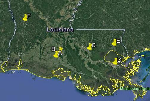
5 Type of RCUT Intersection in Louisiana RCUT Intersection J(6) Intersection (150 ft) JJ(2) JJJ(2) 5
6 Summary Location District Location setting and Type of Year of AADT Highway Type Traffic Control Construction before/after US 167 at LA Rural 4-lane divided 2-way stop ,100/19,133 LA 21 at Zinnia Road 62 Urban 4-lane divided 2-way stop ,900/24,200 Alexandria HY. at Kurthwood 8 Urban 4-lane divided 2-way stop ,067/9,367 LA 45 at 10 th street 2 Urban 4-lane divided 2-way stop ,233 /35,900 US 61 at LA Urban 4-lane divided Signal ,900 /41,900 US 90 at Morgan Ave. 3 Urban 6-lane divided Signal ,833/56,000 US 90 at Perimeter Road 3 Urban 6-lane divided One-way stop (T) 2012 US 90 at Kol Drive 3 Urban 6-lane divided One-way stop (T) 2012 US 90 at Park Centre Road 3 Urban 6-lane divided One-way stop (T) 2012 US 90 at Girouard Drive 3 Urban 6-lane divided One-way stop (T)
7 LA167 at 699 LA45 at 10 th St. US61 at LA42 LA 21 at Zinnia Dr. Alexandria Highway at Kurthwood Rd.
8 Location # of lanes on minor street Variation in Details # of LT lane on Main Highway Length (Mile) Signage on Minor Road U-Turn to Street or Driveway? Raised Island for LT? # of Driveways In between Speed Limit US 167 at LA 699 (rural) NO Both no No 0 55 LA 21 at Zinnia Rd NO One yes, one no No 4 35 Alexandria Hwy at Kurthwood Rd NO Both no, but... Yes LA 45 at 10 th Street 2 1 N/A NO 2 signalized int. No N/A 35 US 61 at LA 42 (signal) YES Both no Yes US 90 at Morgan Ave. (signal 6D) YES Both no, but No 6 55 Diagrammatic Signage 8
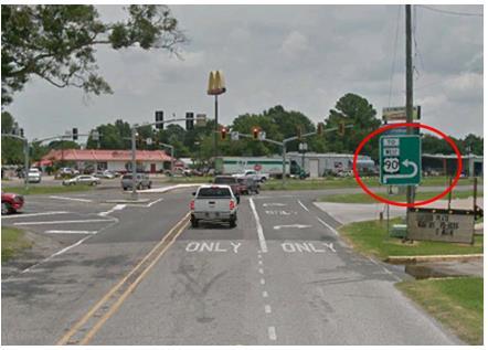


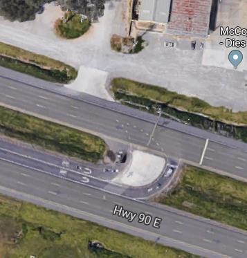
9 US 90 Alexandria Directional Signage


10 Pavement Markings Available on all Minor Approaches except One Kurthwood Rd. at Alexandria Hwy. US 90 at Girouard Rd. Lane separator marking, 250 feet 10
11 Change in Crashes (3 years before and after project year) RCUT Intersections Total Crashes Fatal Crashes Injury Crashes PDO Crashes Before After Before After Before After Before After US 167 at LA 699 (4ST) LA 21 at Zinnia Rd. (4ST) Alexandria Highway at Kurthwood Rd. (4ST) LA 45 at 10 th street, (4ST) US 61 at LA 42, (4SG) US 90 at Morgan Ave. (4SG) Total crashes Percent change in crashes 13% 100% 13% 13%
12 Crashes by manner of collisions RCUT Intersection Location Non-collision Rear end Right Angle Left turn Right Turn Sideswipe Before After Before After Before After Before After Before After Before After US 167 at LA 699 (4ST) LA 21 at Zinnia Rd. (4ST) Alexandria Highway at Kurthwood Rd. (4ST) LA 45 at 10 th street, (4ST) US 61 at LA 42, (SG) US 90 at Morgan Ave. (4SG) Total Percent change +147% 17% 61% 53% +47% +28% Location (type of traffic control)


")

13 US 167 at LA 699 (2-way stop with flash light) Before After 13
14 Crashes by Year Year AADT Total # crashes Fatal crash Injury crash PDO , , , , , , , By Manner of Collision Total Before Total After MANNER OF COLLISION BEFORE AFTER Non-collision 3 11 Rear end 2 9 Head-on 2 0 Right angle 10 5 Left turn 5 1 Right turn 0 1 Sideswipe 1 5 Total crashes 23 32


15 Before Change in Crashes at this intersection Collision Type Before After Rear-end 1 8 Before After 15
16 Rear-end collisions during the after years at the intersection only (1 to 8)
17 Sideswipe collisions during after years (1 to 5)
18 Non-Collisions after years (1 to 6)

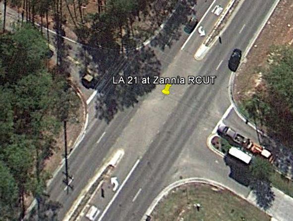
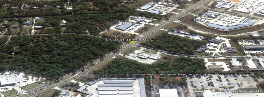

19 LA 21 at Zinnia Intersection Before Location Before After


20 Stop sign Stop sign This J turn has a loon on either u turns to accommodate the heavy vehicles. 4 The distance of 4 drive ways from intersection: 1=200ft 2=480ft 3=410ft 4=230ft Land use near the Intersection
21 Crashes by Year Year AADT Total Fatal Injury PDO , , , , , , , Before After Total Number of crashes decreased by 29%. Injury and PDO crashes decreased as well. So do most types of crashes. By Manner of Collision Manner of Collision Before After Non- collision 1 1 Rear end Right angle 11 3 Left turn 11 5 Right Turn 3 3 Sideswipe 3 4 Others 0 1 Total 49 35


22 Alexandria Highway at Kurthwood Road Before After Raised triangle island
23
24 Crashes by Year Year AADT Total Fatal Injury PDO , , , , , , , Before After By Manner of Collision Manner of Collision Before After Non- collision 2 4 Rear end 9 6 Right angle 5 2 Others 2 1 Total 18 13


25 LA 45 at 10 th Street Before After

.")
26 Only Stop sign post The 10 th street does not have pavement lane marking. No designated U-turn locations at both side of intersection U-turns can be made at two signalized intersections on each side with no U-turn signs Land use near intersection The intersection is near to several schools and institute. (pedestrians are expected). DEAF INSTITUTE
27 Crashes by Year Year AADT Total Acc Fatal Acc Injury Acc PDO Acc , , , , , , , Before years After years By Manner of Collision Manner of Collision Before After Non- collision 3 2 Rear end Head On 0 1 Right angle 19 2 Left turn 6 1 Right Turn 3 5 Sideswipe 9 5 Total 73 42


28 US 61 at LA 42 Before After


29 Loon/bay is provided for each U turns for accommodation of heavy vehicles. # of driveways=20 CVS Residential Area Land use near the intersection
30 Crashes by Year Year AADT Total Fatal Injury PDO , , , , , , , Before After By Manner of Collision Manner of Collision Before After Non- collision 6 11 Rear end Head On 4 6 Right angle 14 8 Left turn Right Turn 6 7 Sideswipe Total
31 Sideswipe at main intersection
32 More sideswipes 32

33 Driver s inattention Aggressive lane changing Driver s inattention

")

34 US 90 at Morgan Ave. (4SG) Before After 34
35 Crashes by Year Year AADT Total # crashes Fatal Injury crashes crashes PDO crashes , , , , , , TOTAL Before After By Manner of Collision MANNER OF COLLISION BEFORE AFTER Non-collision 2 13 Rear end Head-on 2 3 Right angle 15 9 Left turn 11 5 Right turn 5 11 Sideswipe 8 11 Total
36 Five Non-collision with J-turn 1. Driver 2 made an illegal U-turn at the J-turn intersection and in order to avoid vehicle 1 swerve off to strike the median island. 2. Large truck making left turn at the J-turn intersection, its back strike the traffic signal post. (Inattentiveness) 3. Unit 2 strike with the box panel dropped from unit 1 travelling ahead of it. 4. When making right to enter a parking lot, vehicle ran off the road to a ditch. 36
37 Right-Turn Collisions


38 LA167 at 699 LA45 at 10 th St. US61 at LA42 LA 21 at Zinnia Dr. Alexandria Highway at Kurthwood Rd.
39 RCUT Intersection Location Non-collision Rear end Right Angle Left turn Right Turn Sideswipe Before After Before After Before After Before After Before After Before After US 167 at LA 699 (4ST) LA 21 at Zinnia Rd. (4ST) Alexandria Highway at Kurthwood Rd. (4ST) LA 45 at 10 th street, (4ST) US 61 at LA 42, (SG) US 90 at Morgan Ave. (SG) Over all crashes Percent change in crashes +147% 17% 61% 53% +47% +28% Any correlations? Location # of lanes on minor street # of LT lane on Main Highway Length (Mile) Signage on Minor Road U-Turn to Street or Driveway? Raised Island for LT? # of Driveways In between US 167 at LA 699 (rural) NO Both no No 0 55 LA 21 at Zinnia Rd NO One yes, one no Yes 4 35/45 Alexandria at Kurthwood Rd NO Both no, but (UP) Yes LA 45 at 10 th Street 2 1 N/A NO Two signals No N/A 35 US 61 at LA YES Both no Yes US 90 at Morgan Ave YES Both no, but (DN) No 6 55 Speed Limit mph
40 CMF for RCUT by Improved Method RCUT Intersections θ σ(θ) θ 2σ(θ) θ + 2σ(θ) US 167 at LA 699 (J) LA 21 at Zinnia Rd. (J) Kurthwood Rd. at Alexandria Hwy. (J) LA 45 at 10 th Street (J) US 61 at LA 42 (J) Total
41 Cost and Benefit Analysis Source Cost Features Nicholas Fruge (District 3) $300,000 Bi-directional partial median opening with turn lanes DOTD Project (DOTD website) US 167 at LA 699 $3.5 million J turn+ resurfacing of 9.3 mile stretch LA 1 at Sugar Plantation $500,000 to 1million Proposed with bulb-out U turns US 90 in between Billeaud overpass and Wall Road US 171 at N. Perkins Ferry Road (In operation since 28 th December, 2016) $ 4.9 million Proposed Project $500,000 to 1million J turn along with Subgrade treatment, Class II base course laying 41
42 Louisiana Unit Cost per Crash by Severity Crash Severity Type Crash Report Injury Code Unit Cost Per crash Fatal A $1,710,561 Severe Injuries B $489,446 Moderate Injury C $173,578 Compliant Injuries D $50,636 PDO E $24,982 Source: _Safety_Analysis_Toolbox.aspx
43 Benefit Cost Ratio Complete Intersection Location Reduction in Crashes by Injury Type Fatal Severe Moderate Complaint PDO Total Safety Benefit Total Construction Cost US 167 at LA $2,563,919 $300,000 LA 21 at Zinnia Rd $1,343,940 $300,000 Kurthwood Rd. at Alexandria Hwy $1,687,547 $300,000 LA 45 at 10th street $1,256,540 $300,000 US 61 at LA $664,526 $300,000 US 90 at Morgan Ave $2,909,104 $300,000 Overall $12,109,270 $3,000,000 B/C ratio = 4.04 Cost per RCUT construction= $500,000, B/C= 2.42
44 Conclusion Improving roadway safety Economically justified Enhancing the intersection capacity The devil is in the detail
45 Thank you! Any Questions?
Evaluation Considerations and Geometric Nuances of Reduced Conflict U-Turn Intersections (RCUTs)
") Evaluation Considerations and Geometric Nuances of Reduced Conflict U-Turn Intersections (RCUTs) 26 th Annual Transportation Research Conference Saint Paul RiverCentre May 20, 2015 Presentation Outline
Evaluation Considerations and Geometric Nuances of Reduced Conflict U-Turn Intersections (RCUTs) 26 th Annual Transportation Research Conference Saint Paul RiverCentre May 20, 2015 Presentation Outline
Access Management: An R-CUT Above the Rest
 Access Management: An R-CUT Above the Rest Presented by Cristine Gowland LADOTD District 62 www.dotd.la.gov What is an R-CUT? Restricted Crossing U-Turn Non-traditional intersection design: Side street
2.0 Development Driveways. Movin Out June 2017
 Movin Out June 2017 1.0 Introduction The proposed Movin Out development is a mixed use development in the northeast quadrant of the intersection of West Broadway and Fayette Avenue in the City of Madison.
Rural Two-Lane Roadways in Louisiana
 Impact of Pavement Edge Line on Vehicular Lateral Position on Narrow Rural Two-Lane Roadways in Louisiana Xiaoduan Sun Jaehyun Park University of Louisiana at Lafayette Dean Tekell Nina Ludington Dean
EXCEPTION TO STANDARDS REPORT
 EXCEPTION TO STANDARDS REPORT PROJECT DESCRIPTION AND NEED The project is located in Section 6, Township 23 North, Range 9 East and Section 31 Township 24 North, Range 9 East, in the Town of Stockton,
Speed Limit and Safety Nexus Studies for Automated Enforcement Locations in the District of Columbia 3rd Street Tunnel at Massachusetts Avenue Exit
 Speed Limit and Safety Nexus Studies for Automated Enforcement Locations in the District of Columbia 3rd Street Tunnel at Massachusetts Avenue Exit Study Area and Location District PSA Ward ANC Phase Description
Restricted Crossing U-Turn (RCUT) Intersection Concept, Case Studies, and Design Guide ITE Midwest Annual Meeting June 30, 2015 Branson, MO
 Intersection Concept, Case Studies, and Design Guide ITE Midwest Annual Meeting June 30, 2015 Branson, MO") Restricted Crossing U-Turn (RCUT) Intersection Concept, Case Studies, and Design Guide 2015 ITE Midwest Annual Meeting June 30, 2015 Branson, MO Wei Zhang, Ph.D., P.E. Program Manager, Intersection Safety
Restricted Crossing U-Turn (RCUT) Intersection Concept, Case Studies, and Design Guide 2015 ITE Midwest Annual Meeting June 30, 2015 Branson, MO Wei Zhang, Ph.D., P.E. Program Manager, Intersection Safety
TRAFFIC IMPACT ANALYSIS
 TRAFFIC IMPACT ANALYSIS Emerald Isle Commercial Development Prepared by SEPI Engineering & Construction Prepared for Ark Consulting Group, PLLC March 2016 I. Executive Summary A. Site Location The Emerald
Figure 1 Map of intersection of SR 44 (Ravenna Rd) and Butternut Rd
 and Butternut Rd") Abbreviated Study District: 12 County: Geauga Route: SR 44 Section: 1.58 GEA 44 1.58 213 HSP # 47 (Rural Intersection) Prepared April 23, 215 By Bryan Emery Existing Conditions This study contains the
Abbreviated Study District: 12 County: Geauga Route: SR 44 Section: 1.58 GEA 44 1.58 213 HSP # 47 (Rural Intersection) Prepared April 23, 215 By Bryan Emery Existing Conditions This study contains the
SN01 STANDARD NOTES CITY OF SAMMAMISH 2018 INTERSECTION IMPROVEMENTS PROJECT NO. DATE BY APPR REVISION COSA0023 KING COUNTY WASHINGTON
 STANDARD NOTES SN01 2 OF 17 STANDARD NOTES SN02 3 OF 17 SITE PREP & T.E.S.C. NOTES GENERAL NOTES SITE PREP & T.E.S.C. PLAN SP01 4 OF 17 SITE PREP & T.E.S.C. NOTES GENERAL NOTES SITE PREP & T.E.S.C. PLAN
Purpose and Need Report
 Purpose and Need Report State Highway (SH) 29 From Southwestern Boulevard to SH 95 Williamson County, Texas (CSJ: 0337-02-045) Prepared by Blanton & Associates, Inc. Date: November, 2015 The environmental
2 Min. Min. Edge of. Edgeline See Note 3 PLAN VIEW. See Note 3. This distance may vary
 8" Physical gore ( ) ( ) 250 Varies 250 TYPICAL RUMBLE STRIP PLACEMENT AT EXIT AND ENTRANCE RAMPS This distance may vary This distance may vary ( ) 2 16" edge of R=12" Max ( ) Physical gore Texturing 1.
Support: The Crossbuck (R15-1) sign assigns right-of-way to rail traffic at a highway-rail grade crossing.
 sign assigns right-of-way to rail traffic at a highway-rail grade crossing.") TECHNICAL COMMITTEE: Railroad and Light Rail Transit Technical Committee DATE OF ACTION: June 25, 2004 TOPIC: Crossbuck with Yield or Stop Signs and Advance Signs. STATUS: Accepted by the National Committee
TECHNICAL COMMITTEE: Railroad and Light Rail Transit Technical Committee DATE OF ACTION: June 25, 2004 TOPIC: Crossbuck with Yield or Stop Signs and Advance Signs. STATUS: Accepted by the National Committee
Study Area and Location District PSA Ward ANC Phase Description C Existing 100 Block Michigan Avenue Northeast Westbound
 Speed Limit and Safety Nexus Studies for Automated Enforcement Locations in the District of Columbia 1 Block Michigan Avenue NE W/B Study Area and Location District PSA Ward ANC Phase Description 5 45
USE RESTRICTED 23 USC 409
 Created: 04/29/2016 by Randy Woods Study Map & Totals Legend Fatality Injury Property Damage Remarks: NONE Date Range: 01-01-2006 thru 12-31-2015 2006 2007 2008 Fat Incap Inj Non-Incap Inj Poss Inj PD
Study Area and Location District PSA Ward ANC Phase Description A Proposed Monroe Street Northeast Eastbound at Rhode Island Avenue
 Speed Limit and Safety Nexus Studies for Automated Enforcement Locations in the District of Columbia Monroe Street NE and Rhode Island Avenue NE Study Area and Location District PSA Ward ANC Phase Description
INTERSECTION CONTROL EVALUATION
 INTERSECTION CONTROL EVALUATION Trunk Highway 22 and CSAH 21 (E Hill Street/Shanaska Creek Road) Kasota, Le Sueur County, Minnesota November 2018 Trunk Highway 22 and Le Sueur CSAH 21 (E Hill Street/Shanaska
Workshop Agenda. Bransford Roundabout. Bedford Intersection/Roundabout. Section 3 Revisions (Left turn lanes) Roadway Section/Curb Type Discussion
 Roadway Section/Curb Type Discussion") Workshop Agenda Bransford Roundabout Bedford Intersection/Roundabout Section 3 Revisions (Left turn lanes) Roadway Section/Curb Type Discussion Project Phasing Summary of Recommendation Purpose: Provide
Workshop Agenda Bransford Roundabout Bedford Intersection/Roundabout Section 3 Revisions (Left turn lanes) Roadway Section/Curb Type Discussion Project Phasing Summary of Recommendation Purpose: Provide
800 Access Control, R/W Use Permits and Drive Design
 Table of Contents 801 Access Control... 8-1 801.1 Access Control Directives... 8-1 801.2 Access Control Policies... 8-1 801.2.1 Interstate Limited Access... 8-1 801.2.2 Limited Access... 8-1 801.2.3 Controlled
USE RESTRICTED 23 USC 409
 Created: 06/29/2018 by Lora Koetsier Study Map & Totals Legend Fatality Injury Property Damage Remarks: REQUEST FROM SHELBY TEMPLIN IN SAPM ON 29 JUNE 2018 Date Range: 10-03-2012 thru 10-02-2017 2012 2013
Speed Limit and Safety Nexus Studies for Automated Enforcement Locations in the District of Columbia 3600 Block Martin Luther King, Jr.
 Speed Limit and Safety Nexus Studies for Automated Enforcement Locations in the District of Columbia 36 Block Martin Luther King, Jr. Avenue SE Study Area and Location District PSA Ward ANC Phase Description
SN01 STANDARD NOTES CITY OF SAMMAMISH 2018 FLASHING YELLOW ARROW SIGNALS PROJECT NO. DATE BY APPR REVISION COSA0023 KING COUNTY WASHINGTON
 STANDARD NOTES SN01 2 OF 8 ROADWAY PLAN PL01 3 OF 8 ROADWAY PLAN PL02 4 OF 8 LANE 10 105 150 205 270 450 500 550 11 12 SHOULDER 115 125 MINIMUM LANE CLOSURE TAPER LENGTH = L 165 225 295 180 245 320 5 25
AusRAP assessment of Peak Downs Highway 2013
 AusRAP assessment of Peak Downs Highway 2013 SUMMARY The Royal Automobile Club of Queensland (RACQ) commissioned an AusRAP assessment of Peak Downs Highway based on the irap protocol. The purpose is to
Study Area and Location District PSA Ward ANC Phase Description B Existing 3700 Block Massachusetts Avenue Southeast Southeast-bound
 Speed Limit and Safety Nexus Studies for Automated Enforcement Locations in the District of Columbia 37 Block Massachusetts Avenue SE Study Area and Location District PSA Ward ANC Phase Description 6 65
HIGHWAY SAFETY RESEARCH GROUP. Safety Analysis Tools Used for Coalitions and Districtwide Safety Investment Plans
 Safety Analysis Tools Used for Coalitions and Districtwide Safety Investment Plans 3 Levels of Analysis SHSP Dashboards LOSS Dashboard GIS Tool SHSP Dashboards Strategic Highway Safety Plan The vision
Study Area and Location District PSA Ward ANC Phase Description C Planned Suitland Parkway Westbound at Stanton Road Southeast
 Speed Limit and Safety Nexus Studies for Automated Enforcement Locations in the District of Columbia Suitland Parkway at Stanton Road SE Study Area and Location District PSA Ward ANC Phase Description
Median Barriers in North Carolina -- Long Term Evaluation. Safety Evaluation Group Traffic Safety Systems Management Section
 Median Barriers in North Carolina -- Long Term Evaluation Safety Evaluation Group Traffic Safety Systems Management Section Background In 1998 North Carolina began a three pronged approach to prevent and
Factors Affecting Highway Safety in Louisiana
 Factors Affecting Highway Safety in Louisiana Conducted by the Louisiana Transportation Research Center for the Louisiana Department of Transportation and Development Results Fatality rates 1999 2004 3
COUNTY ROAD SPEED LIMITS. Policy 817 i
 Table of Contents COUNTY ROAD SPEED LIMITS Policy 817.1 PURPOSE... 2.2 APPLICABILITY... 2.3 DEFINITIONS... 2.4 STATE ENABLING LEGISLATION... 3.5 SPEED LIMITS ON COUNTY ROADS (CCC 11.04)... 3.6 ESTABLISHING
Construction Realty Co.
 MEMORANDUM TO: FROM : Jeff Pickus Construction Realty Co. Luay R. Aboona, PE Principal 9575 West Higgins Road, Suite 400 Rosemont, Illinois 60018 p: 847-518-9990 f: 847-518-9987 DATE: May 22, 2014 SUBJECT:
USE RESTRICTED 23 USC 409
 Study Map & Totals Legend Fatality Injury Property Damage Remarks: NONE Date Range: 01-01-2010 thru 12-31-2014 2010 2011 2012 Fat Incap Inj Non-Incap Inj Poss Inj PD Tot Fat Incap Inj Non-Incap Inj Poss
Traffic Impact Study Speedway Gas Station Redevelopment
 Traffic Impact Study Speedway Gas Station Redevelopment Warrenville, Illinois Prepared For: Prepared By: April 11, 2018 Table of Contents 1. Introduction... 1 2. Existing Conditions... 4 Site Location...
Clearlake Road (State Road 501) Project Development & Environment (PD&E) Study
 Project Development & Environment (PD&E) Study") Clearlake Road (State Road 501) Project Development & Environment (PD&E) Study FROM MICHIGAN AVENUE TO INDUSTRY ROAD BREVARD COUNTY, FLORIDA Financial Project ID No: 433605-1-22-01 Federal Aid Project
Clearlake Road (State Road 501) Project Development & Environment (PD&E) Study FROM MICHIGAN AVENUE TO INDUSTRY ROAD BREVARD COUNTY, FLORIDA Financial Project ID No: 433605-1-22-01 Federal Aid Project
Alcohol Related Accidents in Mahoning County:
 Alcohol Related Accidents in Mahoning County: 2013-2015 Alcohol Related Accidents in Mahoning County: 2013-2015 Each year the Eastgate Regional Council of Governments collects crash data from the Ohio
W District Department of Transportation 55 M Street, SE, Suite 400 Washington, DC 20003
 Speed Limit and Safety Nexus Studies for Automated Enforcement Locations in the District of Columbia 35 Block Martin Luther King, Jr. Avenue SE SW/B Study Area and Location District PSA Ward ANC Phase
POLICY FOR THE ESTABLISHMENT AND POSTING OF SPEED LIMITS ON COUNTY AND TOWNSHIP HIGHWAYS WITHIN MCHENRY COUNTY, ILLINOIS
 POLICY FOR THE ESTABLISHMENT AND POSTING OF SPEED LIMITS ON COUNTY AND TOWNSHIP HIGHWAYS WITHIN MCHENRY COUNTY, ILLINOIS MCHENRY COUNTY DIVISION OF TRANSPORTATION 16111 NELSON ROAD WOODSTOCK, IL 60098
Optimizing Cross Boarder Truck Safety. Cross Boarder Regional Truck Transportation Conference. John Woodrooffe
 Optimizing Cross Boarder Truck Safety Cross Boarder Regional Truck Transportation Conference John Woodrooffe June 15, 2005 Overview Examining the truck crash picture Focus on the more significant crash
US 70 Corridor Planning for the Future
 New Bern/James City Area - Work Session US 70 Corridor Planning for the Future Brinson Elementary School Thursday, January 31, 2008 Agenda Sign-in, in, View Maps, Talk to Project Team Public Q & A Session
Speed Limit and Safety Nexus Studies for Automated Enforcement Locations in the District of Columbia 400 Block 14th Street SW
 Speed Limit and Safety Nexus Studies for Automated Enforcement Locations in the District of Columbia 4 Block 4th Street SW Study Area and Location District PSA Ward ANC Phase Description 27 6 6D Existing
VIADUCT LOCATION STUDY. October 19, 2009
 VIADUCT LOCATION STUDY October 19, 2009 Background Information Traffic Study Alternative Evaluation Public Involvement Preferred Concept Next Steps Evaluate alternatives for the location of a viaduct to
TECHNICAL MEMORANDUM. Part A: Introduction
 TECHNICAL MEMORANDUM To: David J. Decker Decker Properties, Inc. 5950 Seminole Centre Ct. Suite 200 Madison, Wisconsin 53711 608-663-1218 Fax: 608-663-1226 www.klengineering.com From: Mike Scarmon, P.E.,
SPATIAL AND TEMPORAL PATTERNS OF FATIGUE RELATED CRASHES IN HAWAII
 SPATIAL AND TEMPORAL PATTERNS OF FATIGUE RELATED CRASHES IN HAWAII By Karl E. Kim Eric Y. Yamashita Hawaii CODES Project Traffic Records Forum July 29 - August 2, 2001 New Orleans, Louisiana Overview Background
2016 Congestion Report
 2016 Congestion Report Metropolitan Freeway System May 2017 2016 Congestion Report 1 Table of Contents Purpose and Need...3 Introduction...3 Methodology...4 2016 Results...5 Explanation of Percentage Miles
Collision Types of Motorcycle Accident and Countermeasures
 Proceedings of the 2 nd World Congress on Civil, Structural, and Environmental Engineering (CSEE 17) Barcelona, Spain April 2 4, 2017 Paper No. ICTE 115 ISSN: 2371-5294 DOI: 10.11159/icte17.115 Collision
The Highway Safety Manual: Will you use your new safety powers for good or evil? April 4, 2011
 The Highway Safety Manual: Will you use your new safety powers for good or evil? April 4, 2011 Introductions Russell Brownlee, M.A. Sc., FITE, P. Eng. Specialize in road user and rail safety Transportation
CHAPTER 9: VEHICULAR ACCESS CONTROL Introduction and Goals Administration Standards
 9.00 Introduction and Goals 9.01 Administration 9.02 Standards 9.1 9.00 INTRODUCTION AND GOALS City streets serve two purposes that are often in conflict moving traffic and accessing property. The higher
HSIP FUNDING APPLICATION
 HSIP FUNDING APPLICATION Lucas County - Sylvania Ave at Centennial Rd DATE 10/6/2011 Project Information: COUNTY Lucas County LOCATION TYPE Intersection PROJECT SERVICE LIFE 20 years SEGMENT INFORMATION
Safety Assessment. Intersection of Route 29 (Seminole Trail) and Ashwood Blvd (Route 1670). Albemarle County
 and Ashwood Blvd (Route 1670). Albemarle County") Safety Assessment for Intersection of Route 29 (Seminole Trail) and Ashwood Blvd (Route 1670). Albemarle County Prepared by: VIRGINIA DEPARTMENT OF TRANSPORTATION Northwestern Regional Operations - Traffic
Safety Assessment for Intersection of Route 29 (Seminole Trail) and Ashwood Blvd (Route 1670). Albemarle County Prepared by: VIRGINIA DEPARTMENT OF TRANSPORTATION Northwestern Regional Operations - Traffic
Roundabout Feasibility Study SR 44 at Grand Avenue TABLE OF CONTENTS
 Roundabout Feasibility Study SR 44 at Grand Avenue TABLE OF CONTENTS Introduction and Executive Summary... 1 Existing Conditions... 3 Intersection Volume Conditions... 5 Intersection Operations... 9 Safety
Study Area and Location District PSA Ward ANC Phase Description C Proposed 2600 Block Lincoln Road Northeast Northbound
 Speed Limit and Safety Nexus Studies for Automated Enforcement Locations in the District of Columbia 2600 Block Lincoln Road NE Study Area and Location District PSA Ward ANC Phase Description 5 502 5 5C
Traffic Impact Analysis West Street Garden Plots Improvements and DuPage River Park Garden Plots Development Naperville, Illinois
 Traffic Impact Analysis West Street Garden Plots Improvements and DuPage River Park Garden Plots Development Naperville, Illinois Submitted by April 9, 2009 Introduction Kenig, Lindgren, O Hara, Aboona,
TRAFFIC DEPARTMENT 404 EAST WASHINGTON BROWNSVILLE, TEXAS City of Brownsville Speed Hump Installation Policy
 A. GENERAL Speed humps are an effective and appropriate device for safely reducing vehicle speeds on certain types of streets when installed accordance with the provisions of this policy. In order for
COUNTY ROAD SPEED LIMITS. Policy 817 i
 Table of Contents COUNTY ROAD SPEED LIMITS Policy 817.1 PURPOSE... 1.2 APPLICABILITY... 1.3 DEFINITIONS... 1.4 STATE ENABLING LEGISLATION... 2.5 SPEED LIMITS ON COUNTY ROADS (CCC 11.04)... 2.6 ESTABLISHING
LaDOTD s s New Traffic Control Details
 LaDOTD s s New Traffic Control Details Louisiana Pavement Conference Baton Rouge, Louisiana October 7, 2004 Charles Adams, P.E., PTOE Objectives Traffic Background Information What Drove the Department
Benefit-Cost Analysis of Curve Safety Treatments. Bryan Wilson, Brad Brimley Texas A&M Transportation Institute
 Benefit-Cost Analysis of Curve Safety Treatments Bryan Wilson, Brad Brimley Texas A&M Transportation Institute B/C Analysis B/C analysis encouraged by TxDOT HSIP HSIP calls the ratio a Safety Improvement
Design and Application of Mini- Roundabout in the U.S.
 Design and Application of Mini- Roundabout in the U.S. ITE MID-COLONIAL DISTRICT & MID-ATLANTIC SECTION 2014 ANNUAL MEETING Session 2B: Roundabouts Not Another YORK in the Road 10:45 to 12:00, May 19,
Metropolitan Freeway System 2013 Congestion Report
 Metropolitan Freeway System 2013 Congestion Report Metro District Office of Operations and Maintenance Regional Transportation Management Center May 2014 Table of Contents PURPOSE AND NEED... 1 INTRODUCTION...
Speed measurements were taken at the following three locations on October 13 and 14, 2016 (See Location Map in Exhibit 1):
:") 2709 McGraw Drive Bloomington, Illinois 61704 p 309.663.8435 f 309.663.1571 www.f-w.com www.greennavigation.com November 4, 2016 Mr. Kevin Kothe, PE City Engineer City of Bloomington Public Works Department
2709 McGraw Drive Bloomington, Illinois 61704 p 309.663.8435 f 309.663.1571 www.f-w.com www.greennavigation.com November 4, 2016 Mr. Kevin Kothe, PE City Engineer City of Bloomington Public Works Department
Evaluation of the Rolling Wheel Deflectometer (RWD) in Louisiana. John Ashley Horne Dr. Mostafa A Elseifi
 in Louisiana. John Ashley Horne Dr. Mostafa A Elseifi") Evaluation of the Rolling Wheel Deflectometer (RWD) in Louisiana John Ashley Horne Dr. Mostafa A Elseifi Introduction Louisiana uses the Falling-Weight Deflectometer (FWD) for project level testing Limitations
Evaluation of the Rolling Wheel Deflectometer (RWD) in Louisiana John Ashley Horne Dr. Mostafa A Elseifi Introduction Louisiana uses the Falling-Weight Deflectometer (FWD) for project level testing Limitations
Access Management Standards
 Access Management Standards This section replaces Access Control Standards on Page number 300-4 of the Engineering Standards passed February 11, 2002 and is an abridged version of the Access Management
VDOT 2008 Road and Bridge Standards Section Transition Curves
 õíßáßáwúkÿîßá VDOT 2008 Road and Bridge s Page Title TC-5.01 & 5.04 802.01 802.02 802.03 802.04 802.05 802.06 Explanation of Tables and Instructions for Use General Conditions Transition Curves for Rural
Study Area and Location District PSA Ward ANC Phase Description B Existing 2200 Block South Dakota Avenue Northeast Southeast bound
 Speed Limit and Safety Nexus Studies for Automated Enforcement Locations in the District of Columbia 22 Block South Dakota Avenue NE Study Area and Location District PSA Ward ANC Phase Description 5 53
Memorandum. To: Sue Polka, City Engineer, City of Arden Hills. From: Sean Delmore, PE, PTOE. Date: June 21, 2017
 Memorandum engineering planning environmental construction 701 Xenia Avenue South Suite 300 Minneapolis, MN 55416 Tel: 763-541-4800 Fax: 763-541-1700 To: Sue Polka, City Engineer, City of Arden Hills From:
Engineering Dept. Highways & Transportation Engineering
 The University College of Applied Sciences UCAS Engineering Dept. Highways & Transportation Engineering (BENG 4326) Instructors: Dr. Y. R. Sarraj Chapter 4 Traffic Engineering Studies Reference: Traffic
Study Area and Location District PSA Ward ANC Phase Description B Existing 600 Block New York Avenue Northeast Westbound
 Speed Limit and Safety Nexus Studies for Automated Enforcement Locations in the District of Columbia 6 Block New York Avenue NE Study Area and Location District PSA Ward ANC Phase Description 5 55 5 5B
RTE. 1 at RTE. 637 & RTE. 639
 INTERSECTION SAFETY STUDY Prepared for: Virginia Department of Transportation Central Region Operations Traffic Engineering (UPC #81378, TO 12-092) DAVENPORT Project Number: 13-368 / /2014 RTE. 1 at RTE.
March 2, 2017 Integrating Transportation Planning, Project Development, and Project Programming
 COORDINATION WITH VDOT DISTRICTS TO DELIVER IMPLEMENTABLE IMPROVEMENT PROJECTS March 2, 2017 Integrating Transportation Planning, Project Development, and Project Programming PRESENTATION OUTLINE What
Alberta Transportation Rumble Strips - C-TEP Lunch and Learn
 Alberta Transportation Rumble Strips - C-TEP Lunch and Learn Bill Kenny P.Eng, Director: Design, Project Management and Training, Technical Standards Branch. - July 2011 What are Rumble Strips? A preventative
City of Pacific Grove
 Regional Study Utilizing Caltrans Intersection Evaluation Section 7: City of Pacific Grove s: FIRST STREET AT CENTRAL AVENUE Transportation Agency for Monterey County Prepared by Transportation Agency
ACCIDENT MODIFICATION FACTORS FOR MEDIAN WIDTH
 APPENDIX G ACCIDENT MODIFICATION FACTORS FOR MEDIAN WIDTH INTRODUCTION Studies on the effect of median width have shown that increasing width reduces crossmedian crashes, but the amount of reduction varies
Corridor Sketch Summary
 Corridor Sketch Summary SR 241: I-82 Jct (Sunnyside) to SR 24 Jct Corridor Highway No. 241 Mileposts: 7.53 to 25.21 Length: 17.65 miles Corridor Description The seventeen and one-half mile corridor begins
Harlem Avenue between 63 rd and 65 th
 Harlem Avenue between 63 rd and 65 th Community Advisory Group Meeting #3 December 1, 2017 Bedford Park Public Library 1 Meeting Agenda 1. Welcome/Introductions (3 mins) 2. Project Overview and Re-Cap
April 7, Mr. Blake Shutler Compass Homes Development LLC Summit Homes Construction, LLC PO Box 6539 Dillon, CO 80435
 Compass Homes Development LLC Summit Homes Construction, LLC PO Box 6539 Dillon, CO 80435 Re: Trip Generation Comparison West Hills Townhomes Keystone, Colorado FHU Reference No. 116388-01 Dear Mr. Shutler:
LAWRENCE TRANSIT CENTER LOCATION ANALYSIS 9 TH STREET & ROCKLEDGE ROAD / 21 ST STREET & IOWA STREET LAWRENCE, KANSAS
 LAWRENCE TRANSIT CENTER LOCATION ANALYSIS 9 TH STREET & ROCKLEDGE ROAD / 21 ST STREET & IOWA STREET LAWRENCE, KANSAS TRAFFIC IMPACT STUDY FEBRUARY 214 OA Project No. 213-542 TABLE OF CONTENTS 1. INTRODUCTION...
Highway 18 BNSF Railroad Overpass Feasibility Study Craighead County. Executive Summary
 Highway 18 BNSF Railroad Overpass Feasibility Study Craighead County Executive Summary October 2014 Highway 18 BNSF Railroad Overpass Feasibility Study Craighead County Executive Summary October 2014 Prepared
Table Existing Traffic Conditions for Arterial Segments along Construction Access Route. Daily
 5.8 TRAFFIC, ACCESS, AND CIRCULATION This section describes existing traffic conditions in the project area; summarizes applicable regulations; and analyzes the potential traffic, access, and circulation
Speed Limit Study: Traffic Engineering Report
 Speed Limit Study: Traffic Engineering Report This report documents the engineering and traffic investigation required by Vermont Statutes Annotated Title 23, Chapter 13 1007 for a municipal legislative
MEMO VIA . Ms. Amy Roth DPS Director, City of Three Rivers. To:
 MEMO To: Ms. Amy Roth DPS Director, City of Three Rivers VIA EMAIL From: Michael J. Labadie, PE Julie M. Kroll, PE, PTOE Brandon Hayes, PE, P.Eng. Fleis & VandenBrink Date: January 5, 2017 Re: Proposed
IMPROVEMENT CONCEPTS
 IMPROVEMENT CONCEPTS for the South Novato Transit Hub Study Prepared by: January 11, 2010 DKS Associates With Wilbur Smith Associates IMPROVEMENT CONCEPTS Chapter 1: Introduction 1. INTRODUCTION The strategic
Effectiveness of Median Cable Barriers and Rumble Strips
 Effectiveness of Median Cable Barriers and Rumble Strips Chris Poole, Iowa Department of Transportation Peter Savolainen, Iowa State University Mid-Continent Transportation Research Symposium August 16,
City of Marina. Regional Roundabout Study Utilizing Caltrans Intersection Control Evaluation Section 4: Transportation Agency for Monterey County
 Regional Roundabout Study Utilizing Caltrans Intersection Control Evaluation Section 4: City of Marina Study Intersections: RESERVATION ROAD AT BEACH ROAD RESERVATION ROAD AT DEFOREST ROAD CARDOZA AVENUE
Intersection Design: Switch Point
 Intersection Design: Switch Point W. R. BELLIS Director, Division of Research and Evaluation, New Jersey State Highway Department 'AN intersection of two crossroads in which vehicles do not stop or deviate
Act 229 Evaluation Report
 R22-1 W21-19 W21-20 Act 229 Evaluation Report Prepared for Prepared by Table of Contents 1. Documentation Page 3 2. Executive Summary 4 2.1. Purpose 4 2.2. Evaluation Results 4 3. Background 4 4. Approach
Traffic Accident Statistics
 2000 Missouri State Highway System Traffic Accident Statistics Missouri State Highway System Traffic Accident Statistics Table of Contents Subject Chapter 1: Statewide Traffic Accident Statistics, Introduction
Review of Milled Rumble Strips on Alberta Roads
 Review of Milled Rumble Strips on Alberta Roads Tamara Soltykevych, E.I.T., Alberta Transportation Muzaffar Ahmad, P.Eng, Alberta Transportation Bill Kenny, P.Eng, Alberta Transportation Paper prepared
Louisiana s s Work Zone Task Force Work Zone Improvements
 Louisiana s s Work Zone Task Force Work Zone Improvements Louisiana Asphalt Technology Conference Shreveport, Louisiana February 24, 2005 Charles Adams, P.E., PTOE Why Improve Work Zones? Number of Work
Final Series of Public Meetings
 Final Series of Public Meetings Public Meeting Locations City Date Jasper Monday, September 26 Livingston Tuesday, September 27 Huntsville Wednesday, September 28 Bryan Thursday, September 29 Eldorado
Sight Distance. A fundamental principle of good design is that
 Session 9 Jack Broz, PE, HR Green May 5-7, 2010 Sight Distance A fundamental principle of good design is that the alignment and cross section should provide adequate sight lines for drivers operating their
1999 Missouri State Highway System. Missouri Department of Transportation - Transportation Management Systems
 1999 Missouri State Highway System Traffic Accident Statistics - Transportation Management Systems Missouri State Highway System Traffic Accident Statistics Table of Contents Subject Chapter 1: Statewide
ACCIDENT REVIEW FORM
 ACCIDENT REVIEW FORM American Trucking Associations, Inc. Safety Management Council 950 N. Glebe Road, Suite 210, Arlington, VA 22203-4181 Fax: 703-838-1965 E-Mail: JPierce@trucking.org Members of the
Traffic, Transportation & Civil Engineering Ali R. Khorasani, P.E. P.O. Box 804, Spencer, MA 01562, Tel: (508)
") Associates Traffic, Transportation & Civil Engineering Ali R. Khorasani, P.E. P.O. Box 804, Spencer, MA 01562, Tel: (508) 885-5121 Ms. Teri Ford, Associate 800 Boylston Street, Suite 1570 Boston, MA July
Associates Traffic, Transportation & Civil Engineering Ali R. Khorasani, P.E. P.O. Box 804, Spencer, MA 01562, Tel: (508) 885-5121 Ms. Teri Ford, Associate 800 Boylston Street, Suite 1570 Boston, MA July
Understanding and Identifying Crashes on Curves for Safety Improvement Potential in Illinois
 Understanding and Identifying Crashes on Curves for Safety Improvement Potential in Illinois Priscilla Tobias, P.E. Mouyid Islam, Ph.D. Kim Kolody, P.E. Optional Agenda Image Title Background Workflow
Citizens Committee for Facilities
 Citizens Committee for Facilities AGENDA Thursday, December 11, 2014 City Council Chambers 305 3 rd Avenue East -Twin Falls, Idaho 11:30 A.M. AGENDA ITEMS Purpose By 1. Discussion and possible action on
Slow Down! Why speed is important in realizing your Vision Zero goals and how to achieve the speeds you need
 Slow Down! Why speed is important in realizing your Vision Zero goals and how to achieve the speeds you need Lake McTighe, METRO Joel McCarroll, ODOT Jenna Marmon, ODOT Matt Ferris-Smith, PBOT Oregon Active
CITY OF PORTSMOUTH DEPARTMENT OF PUBLIC WORKS (DPW) DRIVEWAY RULES AND PROCEDURES
 DRIVEWAY RULES AND PROCEDURES") CITY OF PORTSMOUTH DEPARTMENT OF PUBLIC WORKS (DPW) DRIVEWAY RULES AND PROCEDURES The purpose of a driveway permit is to secure access from a private property to the public right-of-way. It is required
CITY OF PORTSMOUTH DEPARTMENT OF PUBLIC WORKS (DPW) DRIVEWAY RULES AND PROCEDURES The purpose of a driveway permit is to secure access from a private property to the public right-of-way. It is required
Plainfield, Indiana Speed Limit Study
 March 21 st, 2017 Prepared on behalf of: Town of Plainfield Building and Engineering Department 206 W. Main Street Plainfield, IN 46168 (317) 839-2561 Prepared by: Thomas S. Vandenberg, PE, PTOE Matthew
STOPPING SIGHT DISTANCE AS A MINIMUM CRITERION FOR APPROACH SPACING
 STOPPING SIGHT DISTANCE AS A MINIMUM CRITERION prepared for Oregon Department of Transportation Salem, Oregon by the Transportation Research Institute Oregon State University Corvallis, Oregon 97331-4304
Traffic Engineering Study
 Traffic Engineering Study Bellaire Boulevard Prepared For: International Management District Technical Services, Inc. Texas Registered Engineering Firm F-3580 November 2009 Executive Summary has been requested
Speed Zoning. District Traffic Engineer ISHC, Seymour, Indiana
 Speed Zoning D e l m a r L. K lo eker District Traffic Engineer ISHC, Seymour, Indiana IN T R O D U C T IO N One of the concerns of the Indiana State Highway Commission and citizens throughout the state
Final Report for. Reedsport. Pedestrian Safety Study. Prepared for. Prepared by. in association with
 Final Report for Reedsport Pedestrian Safety Study Prepared for Prepared by in association with February 2015 ACKNOWLEDGEMENTS This report was prepared through the collective effort of the following people: